 |
Caribbean Hurricane Network
- 2 0 1 7 Season - |
|
|
|
2017 Atlantic Hurricane Season |
|
| Arlene | Bret | Cindy | Don | Emily | Franklin | Gert | Harvey | Irma | Jose | Katia | Lee | Maria | Nate | Ophelia | Philippe | Rina | |
I will write a little recap soon...
 |  |
- - - Left: Irma over the Virgin Islands, right: over St.Maarten/St.Martin. Original source: Navy/NRL Monterey - - - |
Following is an archive of all weather discussions Dave and I posted. They are in reverse chronological order, with the most recent storm discussion on top. If you want more background in formation on specific storms, I have found the 2017 Atlantic Hurricane Season section in the Wikipedia a great resource. Also, visit the Hurricane Research Division of NOAA's Atlantic Oceanographic and Meteorological Lab for 'best track' data of all 2017 storms. The track map below is from that website as well.
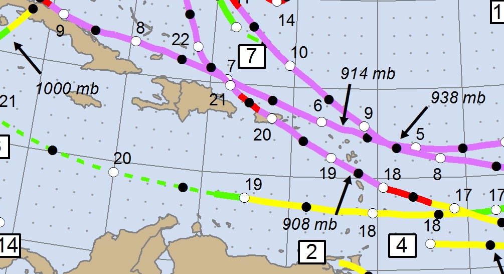
- - 2017 Hurricane Tracks - -
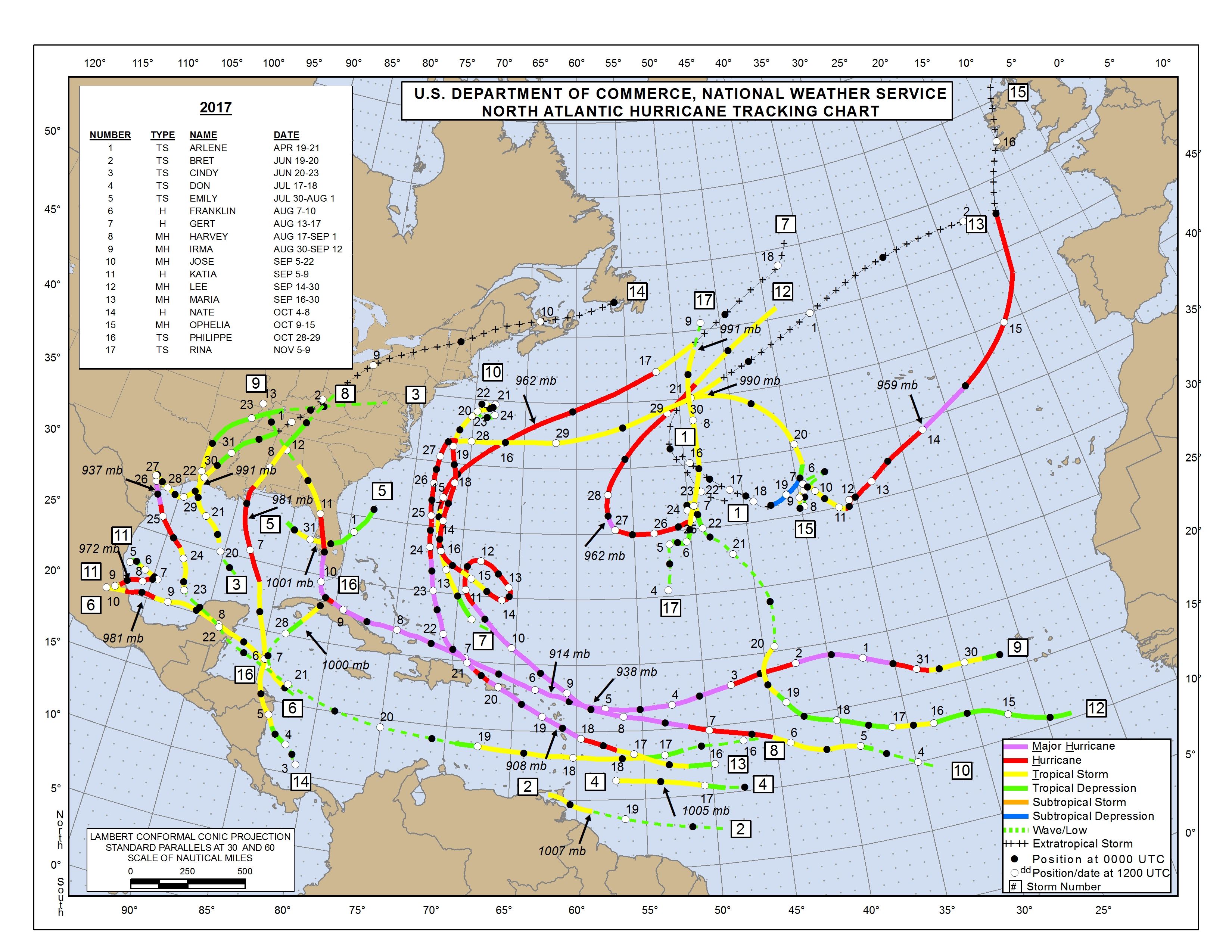
- - Source: NOAA/AOML Hurricane Research Division (click on image for larger size) - -
Weather discussions by Gert & Dave during the 2017 Atlantic Hurricane Season. The homepage with the links to local reports from the islands, latest satellite image, current weather outlook can be found here.
Thursday, November 30, 2017 11:57AM PST - The Atlantic hurricane season from hell is finally over
- Brian McNoldy couldn't say it better in today's 'Capital Weather Gang' posting in the Washington Post. Irma and Maria were devastating for most of the northeastern islands. Judging from the reports submitted by the hurricane correspondents, things are getting better, but still a lot of progress needs to be made... -Gert
Thursday, November 23, 2017 10:22AM EST
- Thanks
-
Good morning!
Happy Thanksgiving to all who celebrate this mainly American Holiday but also thanks to all who have endured, survived and assisted in the rebuilding efforts of all of our Caribbean family. As a village we all get stronger and persevere!
Dave
Monday, November 6, 2017 12:57PM EST
- Possibilities
-
Good afternoon,
I hope all is going as well as possibly can with the rebuild, recovery and restoration efforts in the NE Caribbean as we head into the last three weeks of official hurricane season. Progress is slow, greed among the airlines charging enormous dollars while restricting flights (a lot of people want to get away but can't even for a few days) is ridiculous (I can fly to Honolulu for $1251 but to fly to upstate NY it was $2441 from here in VI for the exact same dates!), and many landlords are worse, charging rent for inhospitable living quarters and threatening unlawful evictions. However, bright spots are showing progress being made in the form of power restoration, quality food products returning to shelves and gas/diesel in good supply. A ginormous thank you to the linemen and line women who have come from their own homes to way less than ideal conditions to assist with the power restoration as it is a humongous undertaking. The roads, well, it needs to stop raining for one thing and the road contractors need to have working equipment.
Ok, on to what to look forward to possibly in the next few weeks. Two of the current models, one fairly consistent and one usually out on Venus, predict possible tropical formation in the Western Caribbean with a Wrong Way Lennyesque track implication. As most of us know who have lived in the Caribbean for many years, Lenny formed on November 13th in 1999 and primarily went the exact opposite of the direction hurricanes traditionally travel. Backwards from west to east. Hence the Wrong way moniker. I remember it well as I had to spend my birthday under curfew. Hurricane Omar tried in Oct 2008, but only traveled from the SW to the NE, which is still rare because of it's southerly formation. Both of these systems impacted the NE Caribbean causing widespread damage and fatalities. So, something to watch out for as it's not over until it's over. As if to reinforce that, we now have TD#19, soon to be TS Rina.
Soon to be TS Rina is no threat to us here in the Caribbean while looking like she wants a date with Scotland, first brushing the north of Ireland at this point as a strong North Atlantic storm but with much less intensity than Hurricane Ophelia back on Oct 16th. Soon to be Rina is not likely to become a minimal hurricane before the cold waters of the Atlantic shut her down but in the season, nothing is impossible.
Keep vigilant!
Dave
Wednesday, October 25, 2017 21:54PM EDT
- 93L and East
-
Good evening,
93L I will chat about first underneath my flashlight. While interacting with the land masses of Central America and the Western Caribbean, 93L does not stand a chance of further development other than it's flashy convection and disorganized activity. However, if it decides to travel a bit more east and get away from the land areas, then it has a chance to become something. What that may become is the big question. A TD, a TS, a hurricane per chance? Or a dud killed off by a strong cold front and wind shear basically relegating 93L to just that: a non formally named entity who has the potential though to dump copious amounts of rain on Cuba, maybe the Caymans, mid to south Florida and the Bahamas through Sunday. For these areas, we shall see soon what will become of 93L. Very warm SST's and moderate wind shear are the positives for development. Negatives are closeness to land, lack of spin, and an increasing severe wind shear threat from an early winter season cold front. In any event, rainfall along this track will be heavy and probably intense meaning 5-6 inches of rain in South Florida, Cuba and some Bahama Islands. Further up/down the road, it could intensify into an early season Nor'easter affecting the outer banks of the Carolinas and run up into New England as a powerful low pressure system which has managed to drop 30-40 millibars in pressure from Florida to NE. Your lucky up in NE if this verifies as 3-4 feet of snow would fall if temps were cold enough. As it is, 4-5 inches of rain are possible. Again, this is a few days out but very possible given the circumstances. Its good to keep an eye closely on these storms in the Western Gulf though as some bad systems have arisen from this area over the years including big hurricanes spinning up out of seeming nowhere. Be vigilant.
Off to our east we have an approaching tropical wave which, if it wasn't for fierce wind shear, we would probably be experiencing a Cat 2 or 3 hurricane approaching. Weak, discombobulated, elongated but nevertheless approaching inexorably slow, this tropical wave will dump decent rains where they do not need to be dumped this weekend. Behind this one, not much else is a threat. There is a small area of favorable wind shear just south of St. Croix which might enhance this waves rainfall a bit but that's about it.
Hope all are well and as good as can possibly be right now. Still, preparedness is a good thing and helping your neighbors, elderly friends and even a few strangers who are appreciative of your generosity and good will goes a long way to our regions recovery.
Good night, Dave
Tuesday, October 17, 2017 08:55AM EDT
- Quiet
-
Good morning,
It's quick update time.
Well, it's been a long time since the tropical weather update stated "Tropical cyclone formation is not expected for the next 5 days". Good as we needed the break!
92L dumped copious amounts of unwanted, unneeded rain on the NE Caribbean this weekend and now has a date with Bermuda as possibly a weak TS, a TD, or just as the invest it is. Regardless, they will experience some squally weather but not much else.
Off to the east, there are several waves as to be expected but development is not expected due to hostile wind shear. Still, periods of rain will cross the islands from time to time.
Dave
Friday, October 13, 2017 16:45PM EDT
- 92L
-
Good afternoon,
With the concentration of most weather experts watching the ever growing legacy of Hurricane Ophelia, soon to have a date with the southern Azores and eventually Ireland, our attention is focused on our neck of the woods, aka the Caribbean. And yes, the NHC finally designated the tropical wave in close proximity off to our east an Invest, 92L, which I had mentioned it should have yesterday due to it's potential plus the fact many nerves are frayed and stress is at an all time level after the passing of our twin Cat 5's last month. There is much edginess with the unknown.
92L is currently an elongated tropical wave which, down the road a few days, has the potential to become TS Philippe as it treks to the WNW about 15 mph with a more NNW component soon to be evident. This trek puts 92L over and around the NE Caribbean with gusty winds, heavy downpours, and rough seas but no real development as a named entity with a closed center of circulation due to high wind shear. This wind shear is expected to keep development at bay for at least the next 4-5 days. The NE Caribbean, including the BVI's, USVI and Puerto Rico plus Antigua, Anguilla, Barbuda and St. Maarten/St. Martin should expect this unwanted visitor late this weekend with Bermuda a possible pit stop on it's way to the North Atlantic graveyard.. Again, development is not expected until after passing north of the islands but at this point, there is not much difference in the weather conditions of a strong, active tropical wave and a tropical depression. Heavy rains, squally gusty winds and rough seas will only serve to exacerbate the NE Caribbean Islands issues on the way to recovering from Irma and Maria.
Be prepared as you can be and vigilant. With the way this season is going, I believe a few more surprises may be in store.
Dave
Thursday, October 12, 2017 19:04PM EDT
- Lurking
-
Good evening,
The cleanup, restoration, human suffering, continued government incompetence, and incessant rains continue as the NE Caribbean struggles to recover from twin Category 5 hurricanes. Puerto Rico appears to be suffering the worst, especially in the human arena. I don't talk politricks, (that is not a misspelling by the way) but I really think it's disgraceful containers of supplies sit at the port while hundreds of thousands are drinking contaminated water, have little to no food, no other basic necessities, no relief from the rains that have been virtually non stop since Maria, and not much hope, especially evident in the rural areas.
Right now the Caribbean as a whole is pretty quiet. Off the coast of Africa we have a wave about to emerge but not looking like a player at this time. What we do have off to our more immediate east is a large, elongated tropical wave which has flared up some good convection today and looks pretty ominous on satellite.
What's interesting is there is much more talk about hurricane Ophelia being the tenth consecutive hurricane in a row (matched by only three other years, all before 1900 and well before satellite eyes in the sky) than there is about this wave. It's obvious the NHC does not think this has any potential to develop and there is little model support for it to at this time. Reasoning seems to come from the upper level wind shear which is apparent on infrared satellite imagery that is pounding this wave in the face. Regardless though, we have seen systems develop and intensify in the face of strong wind shear and this is no ordinary year as it is. SST's are plenty warm enough, humidity is reasonable and there is no Saharan Dust around. So, that leaves the wind shear from a weakening surface trough to the north of the VI and PR. This wave has raised enough convection throughout the day that it should be labeled an Invest in my opinion. If it does develop, little warning will be afforded the islands in the path. If it doesn't develop, still expect squally weather and potentially heavy rains. Again.
Last on hurricane Ophelia. Expected to brush the SE Azores with squally weather and big waves, she is then expected to have a fresh Guinness when it reaches Western Ireland as a strong extra tropical system matching Cat 1 criteria.
Dave
Saturday, October 7, 2017 10:09AM EDT
- Quiet here for now
-
Good morning,
After a pretty intense month, the atmosphere is quiet around the eastern and central Caribbean with a few tropical waves making their way across the MDR (Main Development Region) but showing no clear signs of development mainly due to wind shear. However, with 7 weeks left in the official hurricane season and a second historical peak of these seasons coming up this month, it's way too early to call this season over and take your guard down. Any storm of any magnitude would just enhance the misery of many countries trying to recover from hurricanes Irma and Maria.
The western Caribbean and the Gulf of Mexico start coming into more historical play as we go into the last third of the season and hurricane Nate is probably the vanguard of a few storms to form before all is said and done come end of November. Hurricane Nate is about to kiss the central Gulf Coast between NOLA and Mobile, Al. Now a higher end Cat 1, I still think he can make Cat 2 status right before landfall as an eye wall appears to be trying to form via satellite imagery. Hurricane Hunters will be continuously flying into Nate who is not very impressive looking at this moment but it looks like they did find some 90 mph winds but those are confined to the asymmetrical north and east side while on the western side, some areas are only reaching tropical storm force. This suggests anyone on the south and western sides of land falling Nate will be spared the major wrath while points from NOLA east to Pensacola will be in a more dire predicament with the maximum winds, higher wind gusts, dangerous storm surge (especially Miss and Al), flooding rains and tornado possibilities. There are two bright spots from a meteorological standpoint: Nate is a mover and a shaker speeding along pretty quickly at about 23 mph so he won't be lingering too long thereby minimizing the amounts of rainfall and his strengthening possibilities.
91L is looking pretty healthy south of the Azores and could make it to TS Ophelia but is no threat only to the fishes. An area needs to be watched around the southern Bahamas as well over the next week as a sneaky TS Philippe could make an appearance. That looks like the end of the 9 hurricanes in a row run since 1893 but you never know.
Be safe, smart and prepared!
Dave
Wednesday, October 4, 2017 16:39PM EDT
- I'm back!
-
Good afternoon all,
Thank you for all the inquiries as to how I fared during our two Category 5 visits, first from Hurricane Irma and then Maria a short 12 days later. Needless to say, although I have been through many including the infamous Category 3 Hurricane Marilyn on Skyline Drive in 1995, I do not want to ever experience twin 5's again. One every 20 years is enough. For the USVI, Irma didn't do as much roof destruction as Marilyn did but she destroyed almost everything else. Maria just finished what Irma left and then drowned us as an afterthought.
All of our islands in the NE Caribbean including Puerto Rico are suffering badly but we are resilient and will rebound but all of our islands need assistance. Everything has to be flown in, imported and then the government still wants to charge customs and excise taxes. I know they need to make money as well but people just don't have much in the way of cash flow now to pay for the stuff that comes in as relief for them, especially if you have no job, no roof, maybe no transportation, and no support network. It's not pretty folks.
So, not dwelling on these as they have made their impacts and we all know what we are up against. So, turning to the SW Caribbean, it looks like Honduras, Nicaragua, Mexico and to a lesser extent Costa Rica will soon be dealing with tropical storm Nate, aka TD#16 now. A possible hurricane in a few days as a Cat 1 and maybe a high end Cat 2 if it does an RI (rapid intensification) which is entirely possible, the future track is from Louisiana to western Florida. Anyone from the Texas/LA border to Tampa needs to pay attention to this potentially and surprisingly dangerous system. We have been surprised a lot this year so this should not be a surprise. If wind shear stays fairly strong, it will go along way in suppression keeping it to a TS or low end Cat 1. If not, and it hits a few of those warm water "loop eddys" they call them, it could spell deep trouble for the gulf coast.
Off to our Caribbean east the Atlantic is quiet except for a few tropical waves. Hostile wind shear are keeping these at bay so we will see some rains and breezy winds over the next few days. No storms but still not good for those with tarps, no tarps, and no roofs or windows period. Try to stay dry and safe!
Dave
Monday, September 25, 2017 09:00AM PDT - Time for recovery
- Maria has finally left us, Lee is still around but not posing a threat. Nothing else on the horizon, just a tropical wave a long way away and another one just rolled off Africa. No indication that they will develop into anything yet. So a little peace and quiet. Time to focus on recovery...
Many islands in the Caribbean are hard hit, let us not forget that! Dominica, St.Croix, Puerto Rico, Barbuda, St.Maarten/St.Martin, Anguilla, St.Barts, Tortola, Virgin Gorda, St.John, St.Thomas, Vieques, Culebra, ... am I forgetting any? This is of course unprecedented. Just looking at the pictures I included with my earlier postings is gut wrenching. The high season tourist season is a bust for these islands, which means a loss of their main source of income...
Let's hope for a not too frustrating recovery. I will push to have my special hurricane correspondents to keep posting on this website. Although I still haven't heard from many with communications still a problem. E-mail apparently not the best means of communication after storms like these. Recovery won't be easy, but we have to try our best. -Gert
Friday, September 22, 2017 09:42AM PDT - Maria is leaving
- Maria is finally moving away from the Turks & Caicos. It passed a bit closer to Grand Turk than I expected, only 30 miles, not 50 miles. Maximum sustained winds are at 125 mph (still a Category 3 (major) hurricane). Hurricane force winds extend outwards up to 70 miles, so they were within that range. It is slowly moving at 8 mph towards the northwest. There is a tropical storm warning for the Central Bahamas but Maria should stay a safe distance.
Still not many reports coming in from my hurricane correspondents on Puerto Rico, St.Croix or Dominica. I had just received a text from Isabel, a long time correspondent on St.Croix. She seems fine, but also wrote "We don't have phone service but can occasionally send text messages. No internet.". I also do have contact with our Dave on St.Thomas. He is in good spirits, but looking forward to a hot shower. Hopefully Maria was the final one for this year, we are too tired for a third big one! -Gert
Thursday, September 21, 2017 09:59AM PDT - Still a Cat 3
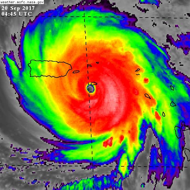
- Finally some time to post again... The situation in Dominica does not seem that good reading CDEMA's first assessment (posted here). I still haven't heard from my hurricane correspondents on the island, due to the poor communications. Hopefully we will hear soon. First reports from St.Croix are not too bad, relatively spoken. Although I don't have a good handle on how the west/south side fared. The same for Puerto Rico, where there apparently is no power on the whole island... And as can be seen on the image above, the rain has not stopped for Puerto Rico, causing flooding and dangerous mudslides in the mountains...
Maria is not done yet, while going over Puerto Rico it weakened a bit, but it is still a Category 3 (major) hurricane with 115 mph winds. Currently it is about 90 miles from Puerta Plata (north coast Dominican Republic), but is slowly at 9 mph moving away from it. The north coast should be just outside hurricane force winds that extend outward up to 60 miles, but within tropical storm winds (extending outward up to 150 mph).
Next target for Maria is the Turks & Caicos Islands, which were hard hit by Irma two weeks ago (175 mph winds..., see Irma and Maria below, two major hurricanes within 2 weeks). The large eye should stay clear of the islands, although the Closest Point of Approach with Grand Turk is only 50 miles... The storm might also strengthen a bit more, now it is back over open water. For the low lying TCI the storm surge will pose a significant risk as well. -Gert
 |  |
- - - Two major hurricanes: Maria (115 mph, left) and Irma (173 mph, right) near Turks & Caicos, 2 weeks apart. Original source: Navy/NRL Monterey - - - |
Wednesday, September 20, 2017 06:37AM PDT - Dominica + St.Croix
- I have just created Pleas for Help forums for Dominica where people can post or communicate with each other about missing persons, property, other news sources, Ross University School of Medicine, etc. There is also another website: CEWN.org (Caribbean Emergency and Weather Network, run by HAM radio operators) where people can register. Their website is overloaded right now though...
I have also created a similar forum for St.Croix, find it here en Vieques here. Hope it helps.
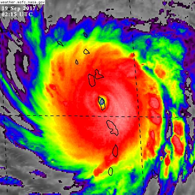
The situation regarding Maria... After skirting by St.Croix it weakened a bit but still passed as a strong Category 4 storm by Vieques who just got the eyewall, and then made landfall near Yabucoa, Puerto Rico at around 6AM this morning. Right now the center is near the northern coast, just 30 miles east of San Juan. It is then expected to pass near the north coast of the Dominican Republic and just to the east of the Turks & Caicos in 36 hours. -Gert
Tuesday, September 19, 2017 22:20PM PDT - Just
- Looks like the eye wall is just reaching St.Croix, see picture below. It could have been worse, but south shore (where the airport is as well) and west side is getting hammered... -Gert
 |
- - - Maria passing by St.Croix - - - |
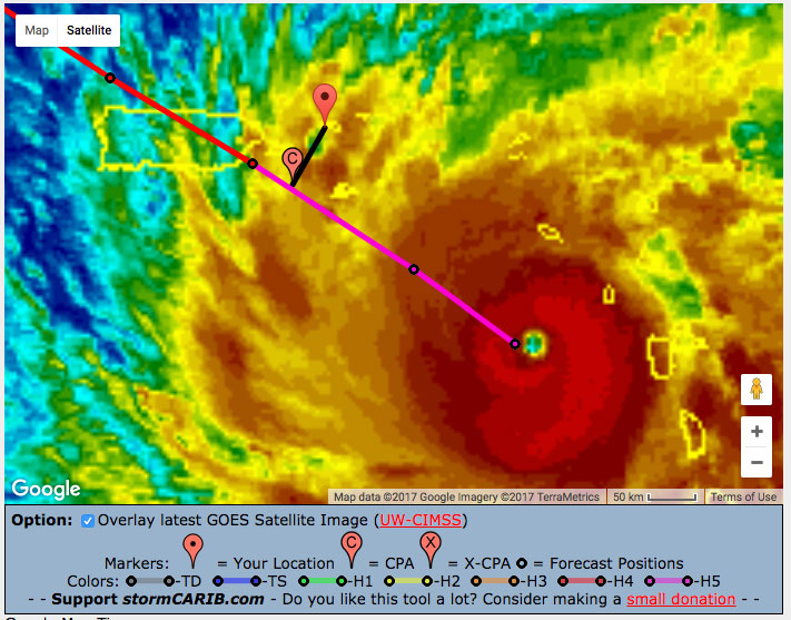
Tuesday, September 19, 2017 19:44PM PDT - 909 mb
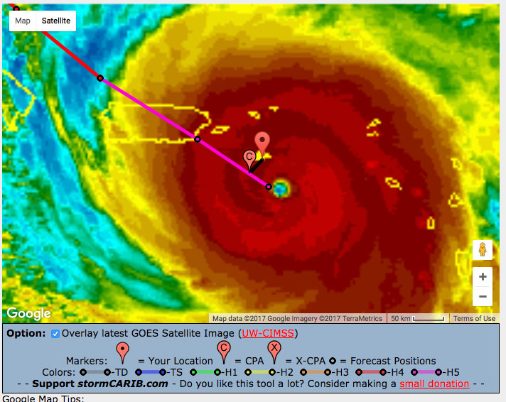
- Currently the center of Maria is only about 30 miles from St.Croix. The Closest Point of Approach (CPA) is only 19 miles to the south. The eye is only 3 hours away from the island. Looking at the satellite image (see below) I think it is actually moving a bit north of the track, so this is basically a direct hit. The central pressure in the eye (measure of strength) has dropped to 909 mb, by comparison Irma's lowest pressure was 914 mb when it was over St.Maarten. This is the 10th lowest minimum pressure ever recorded in the Atlantic. Not a record you want to set just before landfall. Maximum sustained winds are 175 mph (compared to Irma's 185 mph). I am afraid that St.Croix might do worse than St.Thomas and St.John (the other two United States Virgin Islands) did with Irma...
The range of hurricane force winds have also unfortunately increased to 60 miles from the center, with the northeastern quadrant being the strongest (top-right). This means that St.Thomas, with a CPA of 50 miles, and St.John (CPA 59 miles) are just within reach of hurricane force winds. Just to mention this again, these were islands that were hard hit by Irma just two weeks ago. They won't get the same kind of winds, but many homes have leaky or no roofs. I am not sure if a tarp will hold to fend of the rain...
After St.Croix Maria will pass just south of Vieques (21 miles) and then make landfall on the southeastern coast of Puerto Rico tomorrow. At that time Maria is still expected to be a Category 5 storm... Since this is a slow moving storm, there will be flooding and dangerous mudslides in the mountains...., not to mention the storm surge. The only positive thing I see is that now at least it will stay a bit east of the Turks & Caicos (where Irma made landfall as well). Hopefully they will stay clear of hurricane force winds.
Unfortunately I have not heard from my hurricane correspondents on Dominica. I received some HAM Radio relays, which did not sound positive (see island reports on the right). For those who missed it, yesterday I posted a movie made by someone in Dominica, on how to make a safe lamp from simple household materials for when the power goes out. That's it for now. I hate this hurricane season! -Gert
 |
- - - Maria Closest Point of Approach with St.Croix - - - |
Tuesday, September 19, 2017 07:50AM PDT - Dominica
- As I wrote yesterday the eye of Category 5 Hurricane Maria went over Dominica. It will probably a while before I get first hand reports from my special hurricane correspondents on the island... I have at least heard from Guadeloupe and it looks like they came out ok.
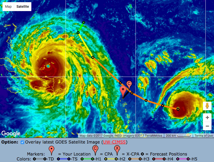
Maria was downgraded to a Category 4, but is now up to Category 5 strength again, with 160 mph sustained winds (with higher gusts). It is heading for St.Croix now, where it might be a direct hit as a Category 5 storm in 18 hours. The Closest Point of Approach (CPA) is only 15 miles to the south. That means that just one wobble of the eye could bring it over the island... Luckily, the eye, with the strongest wind around it, is relatively small. Hurricane force winds (74+ mph) extend outward to 35 miles, so a little wobble or a few miles north or south can make a huge difference. Tropical force winds (39+ mph) extend outward up to 140 miles...
Also sorry to report that St.Thomas, St.John, Tortola and Virgin Gorda, will feel the effects of the storm. These were islands hard hit by Irma just two weeks ago. The CPA for St.Thomas is only 45 miles and for St.John 55 miles. Below satellite image with the track relative to St.Thomas, so show the size of the storm relative to the island... At least Maria will stay relatively far from St.Barts, St.Maarten/St.Martin and Anguilla.
After St.Croix it will be Puerto Rico, with the eye passing only 30 miles to the east of Ponce. Puerto Rico's sister islands' Vieques and Culebra, that were spared during Irma, are now much closer to the storm. The CPA for Vieques is only 17 miles...
As always, although I keep mentioning the track and closest point of approach of the center of the storm, keep in mind that a hurricane is not a point. Hazardous conditions can happen far from the eye. Also, forecasting is not an exact science, so these CPAs can get a lot closer (or further). Listen to the local authorities, and at least, check if you are in the 'cone of uncertainty', see link above. Stay safe everybody, I wish I had better news to report.... -Gert
 |
- - - Maria Closest Point of Approach with St.Thomas - - - |
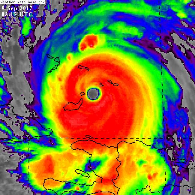
Monday, September 18, 2017 20:01PM PDT - Category 5
- With a heavy heart I am writing that the eye of Maria is currently over Dominica. Maria was upgraded earlier tonight to a Category 5 hurricane. That happened just before it made landfall on Dominica.... Sustained winds are currently 160 mph... The eye is relatively small (compared to Irma) and hurricane force winds extend outward 'only' 30 miles, tropical storm force winds up to 125 miles. There are already reports from HAM radio operators that there is significant damage to structures on Dominica. In addition the storm is moving relatively slow at 9 mph. This is not a good situation for the mountainous island of Dominica.
Further down the road, looking at the latest track the storm is expected to pass really close by St.Croix, on the southside, in 24 hours as a Category 5 storm. With the uncertainty in the track, St.Croix might actually get the eye wall... Things are also looking more dire for St.Thomas and St.John. Closest point of approach for them is only 40 and 50 miles, resp. With so many houses damaged by Irma and a lot of debris everywhere that will not be a good situation either.
After St.Croix it will be Puerto Rico. It is expected to hit the southeastern side near Humacao as 'just' a Category 4 storm, since the forecast shows a weakening, but who knows! In order to assist the people on Puerto Rico, I have added Ponce and Fajardo (the ferry terminal to Culebra/Vieques/USVI/BVI) to the Closest Point of Approach tool.
Finally, with the expected power outages, I received from Negilla on St.Lucia a neat video, showing how to make a safe lantern from a jar, an old t-shirt, and cooking oil. View it here. Below image of Maria over Dominica as I write this... -Gert
 |
- - - Maria over Dominica - - - |
Monday, September 18, 2017 16:29PM EDT
- Maria, Maria
-
Good afternoon,
You would think one Category 5 hurricane for the season was more than enough when, right on Irma's heels, comes another hurricane with her eyes on the Category 5 prize: Maria. Let me say now: Maria means business. This is a dangerous storm with the potential to reach Cat 5 status in the next 12-24 hours meaning devastation rivaling Irmas for all in her path and right now, the bulls eye is on Dominica followed by Guadeloupe.
Dominica should see landfall within the next few hours with Maria probably arriving as a Category 4 and growing system. Satellite and radar presentations suggest her inner eyewall is consolidating strength in the heavy thunderstorm arena. Fortunately, if there is a fortunately, her eye diameter is only 15 miles wide so peak winds are in a small piece of Maria. Still, where they land, it will be catastrophic. This damage will be enhanced by the slower forward motion of 10 mph. Torrential rains, mudslides and flash flooding will also be experienced. Guadeloupe could also feel the eyewall of Maria. The surrounding islands will feel many of the same effects except for the eyewall itself as TS force winds stretch out up to 125 miles. Hence the numerous warnings in place.
Further down the road, it looks like all of the Virgin Islands and Puerto Rico will feel her full fury with St. Croix looking to have a close encounter and Puerto Rico will have an unwanted house guest. The Governor has instituted a curfew for tomorrow at 10 am for the US Virgin Islands from my understanding of his conversation earlier so all preparations need to get done tonight. And curfew starts back up at 6 pm. With wobbles a frequent occurrence, a wobble more northward will place all the Virgin Islands in Maria's cross hairs. So prepare for the worst is the mantra for all.
I'll try to have more tomorrow if I can get out early enough as service is mostly non existent at home on the east end of St. Thomas. Stay safe!!!!
Dave
Monday, September 18, 2017 07:57AM PDT - Hurricane Maria
- Maria has strengthened into a Category 3 hurricane with 120 mph winds. It is expected to become a Category 4 in just 12 hours... Maria is now about 60 miles east of Martinique and on a track to make landfall in Dominica later today as probably a Category 4 hurricane. Again that proves how hard it is to forecast hurricane intensity since just a few days ago it only looked like this was at most going to be 'just' a Category 1 hurricane.
Reports from the islands (see list on the right) show conditions are ok so far. Many hurricane and tropical storm watches and warnings are posted. See the advisories for more info, even some of the islands hard hit by Irma and had a brush of Jose... Hurricane force winds extend outward only 15 miles, and tropical storm force 125 miles, but that range will expand over time of course...
After Dominica Maria will be en route to Puerto Rico where a direct hit is expected in 2 days as a Category 4 with 150 mph winds (ie. borderline Category 5)... The storm's center will stay about 100-120 miles south of St.Maarten/St.Martin, St.Barts and Anguilla, islands devastated by Irma, so within tropical storm force winds range, but not hurricane force winds. St.Croix, that was spared during Irma will now feel the force of Maria. As of now it will just pass about 30 miles south of the island Wednesday early morning. Luckily St.Thomas, St.John, Tortola and Virgin Gorda will be a bit further removed from Maria (60-80 miles), however with the uncertainties of the forecast the advisories give St.Thomas a 94% chance of enduring tropical storm winds and 45% chance of hurricane force winds...
With a lot of debris still laying around and many people with leaking or no roofs this is not going to be fun... And as always, a hurricane is not a point, don't focus on the eye/track alone. Use the tools above to see if you are in the Cone of Uncertainty and take measures as needed. Stay safe, don't do stupid things. -Gert
Sunday, September 17, 2017 14:23PM EDT
- Hurricane Wow
-
Good afternoon all,
First I would like to thank everyone for their concerns, cares and support through the wrath of Hurricane Irma. It hasn't been pretty by any stretch of the imagination and many in our Northeastern Caribbean Islands have been devastated already. I will not dwell on Irma as she is past but never to be forgotten. Irma made Marilyn feel like a newborn. Marilyn's lessons from 1995 were evident as many more roofs and windows survived but the infrastructure of poles, lines and landscape did not. People rally. People help. People pray. People support and give even when they have lost. Then there are the usual suspects: robbers, burglars, looters, greedy merchants, price gougers and the ones who are impatient because they think they are more important then others. Sad fact of society but the good people far outway the bad and that is heartwarming to say the least.
Now, on to Maria. Dominica and Guadeloupe will get Maria first up close and personal as a probable Cat 1. Other islands will feel TS force effects north and south of these islands as Maria is a sprawling system with impacts far from the center. St. Croix, you should be ready for a high end Cat 2 or mid Cat 3 almost direct hit. As it stands now, you are looking at a center 17 miles to your south. St. Thomas, St. John, and the BVI should feel TS winds with hurricane gusts. This is how it stands right now and is subject to Mother Natures changes. I guess she decided St.Croix did not get their fair share.
Right now there is some dry air entraining into Maria. Once this is flushed out, she should strengthen quite rapidly. Her pressure is at 985 mb according to recon with 64kt NW eye winds. She will be a hurricane soon.
What was once TS Lee has left the building. Hurricane Jose, drunk on his own Cuervo, is still staggering around the Atlantic and will be for a while menacing the east coast.There is a wave at 20W to watch and more bowling balls on the African continent. And we just past midpoint in the historical season. Seems like the ladies have the floor!
More as I get better internet and sustained service. Please be prepared for Maria. She will be evil. Not as bad as Irma but she will finish what Irma didn't.
Dave
Sunday, September 17, 2017 09:01AM PDT - Maria
- I know you are all anxious to hear from us about the latest on Maria. Dave will be texting me an update soon. Stay tuned... -Gert
Saturday, September 16, 2017 08:18AM PDT - Fifteen
- This morning 96L was upgraded to Tropical Depression 15. It might become Tropical Storm Maria later today. Right now it looks it will cross the islands near Guadeloupe in about 3 days. By that time it is expected to be a Category 1 Hurricane. Tropical storm watches have actually been issued for St.Lucia, Martinique, Guadeloupe and Dominica.
Keep in mind that there is a lot of uncertainty in both track and the strengthening phase. The spread in the models is quite large. However, they all show that this storm will strengthen, they don't all agree on how fast or how much.
For the islands hard hit by Irma: right now the center of the storm is expected to pass about 70 miles south of Barbuda, 55 miles south of St.Martin and about 30 miles from the USVI (4 days from now)... Quite close, but this is not expected to become a Category 5. The advisories still keep it at a Category 1, even in 5 days. Regardless, all is a bit in flux right now, hope the models will trend south and that it doesn't get too strong. You can use the Closest Point of Approach tool (see above) to check how close it can get to you. Stay tuned. -Gert
Friday, September 15, 2017 16:51PM PDT - 96L
- First of all it is great to see the first hand reports trickling in from the special hurricane correspondents on the islands hard hit by Irma. See the island list on the right. It is pretty amazing to read their accounts... Help is obviously needed, see the Relief Efforts and Where to Donate section or on the individual island pages.
It looks like Tropical Depression 14 is going to lose its battle with wind shear, it might become a tropical storm, but not more than that. Plus it should pass well north of the islands.
Invest 96L on the other hand is not behaving as well. It will most likely become a tropical depression by Sunday. It will be pretty close to the islands by then. Conditions at that time will be favorable for more strengthening. Too early to tell by how much, but it might become a hurricane. Where will it go...? The spaghetti plots above show that it can go basically anywhere. Below image (from Univ. Albany/Tang) shows fewer models. The European model (orange, ECMF) shows a more northernly track than the American one (green, AVNO), crossing the islands in about 3.5 days... Remember that is is still quite far away (and not even a Tropical Depression yet), so these model tracks might be far off. Regardless, 96L definitely poses a potential threat. Let's hope it stays away from those islands affected by Irma. -Gert
Thursday, September 14, 2017 20:34PM PDT - Two Cape Verde storms?
- Right now we have two areas of interest in the far eastern Atlantic. The one most to the east (furthest away) has just been upgraded to Tropical Depression 14 (future Lee?). I don't think we have to worry much about this one. It might strengthen a bit the next day or so, but by five days it is back to just a 45 mph tropical storm. Also, looking at the model tracks it is probably going north of us anyway.
The other area of interest, Invest 96L, might pose a bigger threat. It looks like it will take a more southernly track. Looking at the European Model forecast maps I cannot really find it though. I see a small low pressure system over the islands next Thursday, but it doesn't look like a hurricane or something. It is still a long time away. I really don't want to see another big one this season, we've had more than enough. Right now I don't think either of these two will cause much trouble. Nevertheless, we will have to follow them on their journey west...
And we still have Jose still on our satellite picture! Now a tropical storm, but might become a hurricane again. This one is the most annoying storm ever! However, it should not post a threat to the northern Bahamas. Even the eastern US coast and Bermuda should be fine. Please, disappear dude... Enough already. -Gert
Sunday, September 10, 2017 11:40AM PDT - The Cone of Silence
- John Lawson, reporting from Provo, Turks & Caicos, said it very aptly: "The Cone of Silence". It might be awhile if we hear from our special hurricane correspondents on the islands affected by Irma. Their first priority is trying to get 'their house' in order, and with no power/internet, running out of gas for generators, etc., the last thing on their mind is writing up a report and send it to us... However, you will find a lot of pictures and little blurbs posted in Facebook. I have been corresponding with some people on the islands through Facebook, not email. Amazing.
Hopefully the islands won't be forgotten. This website will stay. The Pleas for Help enables people to communicate with each other during the long, frustrating and stressful aftermath.
Meanwhile, annoying Jose doesn't seem to be leaving us alone. The latest 5-day forecast shows it looping around back to the Bahamas... It is still a long time out (5+ days), but we have to keep monitoring this storm...
Just to remind the people how hard hit the islands were, below two close-up images of Irma when it went over St.Maarten/St.Martin and through the Virgin Islands... They look so tiny compared to the eye... Winds were 185 mph, those winds have twice the storm force as the 130 mph winds blasting Florida right now... -Gert
| |
- - - Left: Irma over the Virgin Islands, right: over St.Maarten/St.Martin. Original source: Navy/NRL Monterey - - - |
Saturday, September 9, 2017 10:48AM PDT - Jose is passing
- It looks like the worst is almost over for the islands with regards to Hurricane Jose. Right now it is passing to northeast of the islands. Currently it is 81 miles from Barbuda, 88 miles from Anguilla, and 95 miles from St.Maarten/St.Martin. It might still come a little closer, but the worst winds were on the northern side. Maximum winds are still 145 mph though, however hurricane force winds (74 mph) extend outward only up to 35 miles (55 km) from the center and tropical storm force winds (39+ mph) extend outward up to 140 miles (220 km). Normally the islands will do fine with a storm like this. But now it is different of course...
Irma is still battering the northern coast of Cuba. Although it has weakened significantly (now 125 mph, a Category 3), it is moving at only 9 mph. Irma will cross the Gulf Stream soon, being over warm and open waters it is expected to strengthen again. How much exactly is hard to predict, it will take about 12 hours for the eye to cross the Gulf Stream, we have crazy things seen happen with storms over warm water... Hopefully all the people have now left the Keys. Property can be replaced, you only have one live. -Gert
PS. I just heard from Dave's Mom that Dave is OK! Dave told her that there was no power and no water and that Irma made Hugo and Marilyn look like a rainstorm... Wishing him the best!
Friday, September 8, 2017 14:31PM PDT - Latest on Jose
- The 5PM advisories didn't change the situation much. Jose is still a Category 4 storm packing 150 mph winds. It is not expected to strengthen much more, but will still be a Category 4 storm when it passes the islands. The eye will not make landfall, but will get close to some. I updated the table below based on the new advisories. The numbers have gone down a bit, yeah! Timing of when the eye is closest is still tomorrow night. At that time tropical storm winds extend outward up to 140 miles and hurricane force winds 25 miles. The northern side of the hurricane is the strongest.
Some specific island info (CPA = Closest Point of Approach in miles, TS-winds = change of tropical storm force winds (39+ mph), H-winds = chance of hurricane force winds (74+ mph)):
     Island   CPA  TS-winds  H-winds
     Antigua      71 m    70%        6%
     Barbuda      41 m    94%       37%
     St.Barts     65 m
     St.Maarten   67 m    81%       17%
     Anguilla     57 m
     St.Kitts     91 m    48%        3%
     St.Thomas   125 m    34%        2%
Meanwhile, Irma is still battering the TCI, north coast of Cuba, and southern Bahamas. It has weakened a bit to 155 mph winds and is now 'just' a Category 4 storm. Sorry to be not more descriptive with this storm, I can only handle that much... -Gert
Friday, September 8, 2017 08:26AM PDT - Jose
- A lot of people are freaking out about Hurricane Jose. It is now a Category 4 storm packing 150mph winds. However, it will not directly hit any of the islands as it looks right now. But it will get close to some. Recon data showed that the center of Jose was a bit more south than previously thought, therefore the storm gets a bit closer than expected. The overall track is still the same, just shifted a bit, so it is not trending west. A Hurricane Watch is in effect for Antigua, Barbuda, and Anguilla, Sint Maarten/St. Martin, St. Barthelemy. As of now hurricane force winds extend outward up to 35 miles (55 km) from the center and tropical storm force winds extend outward up to 115 miles (185 km). It is not expected to strengthen much. Some specific island info (CPA = Closest Point of Approach in miles, TS-winds = change of tropical storm force winds (39+ mph), H-winds = chance of hurricane force winds (74+ mph)):
     Island        CPA  TS-winds  H-winds
     Antigua      62 m    81%       14%
     Barbuda      39 m    95%       47%
     St.Barts     60 m
     St.Maarten   62 m    84%       27%
     Anguilla     52 m
     St.Kitts     87 m    60%        5%
     St.Thomas   121 m    41%        4%
Irma was 185 mph when it hit the islands, the storm force of 185 mph winds is 6 times that of 75 mph winds. As I wrote yesterday, normally a storm like this would be fine for the islands, but with so much loose debris laying around and many houses with damaged (or no) roofs, it is not going to be fun. -Gert
Thursday, September 7, 2017 23:17PM PDT - How to Donate?
- I am getting many email messages from people who want to give money to local relief organizations on the islands. There are some GoFundMe pages going, but I have no clue how legit they are. If someone can help me with instructions on how to donate directly to for example local chapters of the Red Cross, please email me at gert@gobeach.com. Unfortunately I don't have to time to do the research on this... Thanks! -Gert
Thursday, September 7, 2017 20:45PM PDT - Irma/Jose
- Are you sick of me yet? I do hate these island hopper hurricanes! And what I hate more is a second one threatening to do it all over again! The eye of Irma is now just passing just about 35 miles south of Provo, Turks & Caicos, see picture below, Provo is the little triangle, the islands to the south are Little and Great Inagua (Bahamas), click on the 'image' link in the tools section above to see the latest one. Irma is still packing 165 mph winds (Cat 5). Hurricane force winds (74+ mph) extend outward up to 75 miles of the center. Not only the wind, but the storm surge can be very dangerous for the low lying Turks & Caicos... Let's hope for the best. The storm is expected to pass about 160 miles from Nassau, so outside hurricane force winds reach... But other islands in the Bahamas will get closer. Use the Closest Point of Approach-tool to calculate it for your location.
And then we have Hurricane Jose, now a Category 3 hurricane. Hurricane watches have been posted for Antigua, Barbuda, Anguilla, Sint Maarten/St. Martin. Ironically enough all islands hit hard by Irma. But things look a bit better than earlier today. It looks like the track is no longer trending closer, but now further away! Closest Point of Approach with Barbuda is now 64 miles (was 43 miles), for Antigua 90 miles (was 71 miles), for Anguilla 90 miles (was 63 miles) and St.Maarten 99 miles (was 73 miles). Hurricane force winds extend outward up to 35 miles. Jose might strengthen a bit more, but is no longer expected to be a Category 4 storm! Normally a storm like this would be fine for the islands, but with so much loose debris laying around and many houses with damaged (or no) roofs, it is not going to be fun. Very unfortunate, to say it mildly. Also below, showing Jose's track, with Antigua's CPA and Irma to the west, not a pretty picture...
Finally, I want to make people aware of irmatracker.com. If you are looking for a loved one (and looking in my inbox I know that there are many) you can post it there. I think it is a Google initiative, but I am not sure. It might get more exposure than my Pleas for Help forums. Speaking from experience, this is the most difficult time for people 'abroad'. The not knowing. Communications are still very difficult with many of the islands. Although some casualties have been reported, I can assure you that your loved ones are ok, but just unable to contact you... Stay strong everybody! It is not easy. -Gert
 |
- - - Irma passing between Provo and Inagua - - - |
 |
- - - Jose track relative to Antigua and Irma to the left [CPA-tool] - - - |
Thursday, September 7, 2017 07:48AM PDT - Another punch?
- Well, what can I say... this is a very tough time right now. We know many of the islands have been hit hard by this unprecedented hurricane. We are very worried about loved ones. But because communications are down we don't hear from them, and fear the worst... I will tell you, it will be ok, be patient, be strong. This is a very frustrating time, esp. watching the news, I totally agree with Dave regarding coverage in the US. They don't even mention St.Thomas or St.John, I guess the US in USVI doesn't stand for much.
As you can imagine I am getting a lot of email. Unfortunately I don't know the answers to many of your questions... All the news I get I post on this website. I opened the Pleas for Help boards so people can ask specific questions and communicate with each other who are in the same boat.
I do hate to bring this up, but we might have to get ready for another hurricane by Saturday morning. Hurricane watches have been issued for Antigua and Barbuda, tropical storm watches for other islands (that will be upgraded later, see complete advisories). How cruel is that? Unbelievable. Jose, now a Category 1 hurricane, is about 715 miles east of the islands. The Closest Point of Approach for Antigua is only about 71 miles (in 2 days), for Barbuda only 43 miles (!), Anguilla 63 miles and St.Maarten 73 miles. The same islands that got badly hit by Irma. The USVI and BVI are 100+ miles away from the center. It is expected to be a Category 3 hurricane by the time it is closest to the island. It does not look that this hurricane will surprise us and become a Category 5 storm. It is actually already expected to weaken a bit after 36 hours... The strongest winds are on the northern side. Hurricane force winds at the peak intensity (in 36 hours) extend outward up to 35 miles to the northwest and 17 miles to the southwest of the center. Tropical storm force winds (40+ mph) 70-100 miles to the west of the center. This is the side closest to the islands.
Regarding Irma, it is now aiming for the Turks and Caicos. Although Irma has weakened a bit, it is still packing 175mph winds, still devastating. Another significant hazard for the low lying TCI is that the advisories indicate a dangerous storm surge of 15-20 feet above normal tide levels for the TCI..., so look for higher ground if possible. The Bahamas should not underestimate this storm either, esp. since models are trending to the east, so the storm might get closer than you think when Irma turns north. Stay safe everybody! -Gert
Wednesday, September 6, 2017 08:56AM PDT - Irma
- Irma's 185mph wind is only 5 mph shy of the record in the Atlantic (Allen, 1980). More troubling, it was a direct hit for Barbuda, St.Barts, St.Maarten/St.Martin and Anguilla earlier this morning. Not good. The eye is now very close to Tortola, St.Thomas, St.John, Virgin Gorda and surrounding islands. Many hurricane watches have been posted (see advisories). You can use the Closest Point of Approach tool to calculate how close the eye and when can get to you. Find updates from the islands by our special hurricane correspondents on the right.
I have opened up island specific Pleas for Help bulletin boards for Barbuda, St.Barts, St.Maarten/St.Martin and Anguilla. In the past they have (sometimes) worked very well, and it is comforting to know that we are all in this together. You can ask about other people, properties, post news, etc.
Not sure if I dare bring it up, but there is another storm behind Irma: Jose. It is now close to hurricane strength, and might become a Category 2. So far it is expected to pass about 150 miles north of the islands in about 3 days (see Closest Point of Approach-tool for Jose. A safe distance, but still pretty close and models are trending south..., so we have to keep a close eye on this one too...
See below image of Irma's eye over St.Maarten/St.Martin (Anguilla is just to the north, St.Barts just to the south-east, the USVI and BVI are to the left...). If you are in the path of this storm, you know what to do. Stay safe everybody and help each other out.
And finally, a huge THANK YOU to my web host pair Networks. Although this website is hosted on 2 dedicated servers, they were getting overloaded since they are older machines. Pair Networks just swapped the hardware of the main server with minimal downtime! Kudos to them! -Gert
Tuesday, September 5, 2017 22:15PM EDT
- Irma the War Goddess
-
Good evening,
Wow. As this is a family post, I cannot say or exert what I am thinking on a personal side. But, as I shared a few days ago, we ultimately did manifest an annular, circular, evil 185 mph hour high end Cat 5 buzzsaw of a very upset German War Goddess named Irma. (Irmas name germination no pun). I would have rather eaten a cold dish of crow that have been right on this and I will be in the middle of this tomorrow. Ouch.
Hurricane Irma, in 48 hours, has become the second most powerful storm in the Atlantic, at the moment, going from 115 mph 48 hours ago to a 185 mph high end hurricane now. Wow!! Props given!! Now, turn north please!! But until maybeeeeee Florida, not happening.
However, sadly that is not going to happen. In the near term, most of the NE Leeward Islands are screwed, aka Antigua, Anguilla, Barbuda, St. Barths, Statia, St. Maarten/Martin, plus Guadeloupe and Dominica in the short term with Antigua and Barbuda up first. My friends in St. Maarten I just communicated with, please be safe!! You have been through these before, not just as strong. Long term, as in the next few days, our very own US Virgin Islands (which the Weather Channel still cursory mentions) will be ravaged as well. St. Croix will be the unwelcome recipient of hurricane force winds on the northern coast while the islands of St. Thomas and St. John will be beat up with sustained hurricane winds of 95-130 mph. Storm surge is looking at 5-10 feet with offshore seas a wow factor of 20-40ft!! Local folks, this is ugly. You who decide to ride it out on your boats, the ME office already has your cadaver carriers, aka body bags ready which they picked up from our warehouse around noon. A spade is a spade. You are worse than stupid to stay on a boat, even in the mangroves, with a hurricane approaching with winds at 185, accompanying storm surge and a wobbler. Please write your name and SS# on your arm with a sharpie so they may identify you to your next of kin if found.
Hurricane force winds are out about 60 miles. Interesting as they go from 185 mph to 74 mph in just 60 miles, So, we are expected to be only 20 miles from the southern eye about 6:30 tomorrow night here in St. Thomas. Realistically, unless a sharp turn aka hurricane Luis wise happens which does not appear likely the northern islands will be under serious assault from 2-10 pm tomorrow afternoon/night. I'd have almost rathered it made a beeline due west yesterday, minimizing damage and destruction instead of its slowwwwwwwww move WNW.
Bottom line: The islands to our east, your under the gun in just a few hours with apocalyptic almost biblical devastation. Here in the US and BVI's tomorrow, we will see a lesser amount of devastation unless Irma wobbles to the south but huge catastrophe none the less.
I am not discussing the future of Irma as she has many options nearing Florida. What I will say is Puerto Rico, the DR, Turks and Caicos, Bahamas and the Keys are in the crosshairs. Mandatory evacuations for the Keys have been implemented. Irma might go up Fl east coast. She might split hairs and go right up the middle of the peninsula. Or she might enter the Gulf of Mexico, do a "right turn Clyde" and sadly give Tampa what it has been missing all these years. I hope not as I love that area.
Either way, it's gonna suck for the next few days here for all of us in the NE Caribbean. I'm looking at 190-195 soon tying or surpassing hurricane Allen. Blessings, prayers and wisdom to all. If your thinking about staying on a boat during this, please see paragraph 3. I will have a new post tomorrow early as I have no idea when power and internet will cease.
Be safe as you can possibly bee!
Dave
Tuesday, September 5, 2017 07:00AM PDT - Category 5
- Irma has become an extremely dangerous Category 5 hurricane, just before it will hit the islands. Sustained winds are expected to top 180mph! Hurricane warnings are in effect for: A Hurricane Warning is in effect for: Antigua, Barbuda, Anguilla, Montserrat, St. Kitts, Nevis, Saba, St. Eustatius, and Sint Maarten/Saint Martin, Saint Barthelemy, British Virgin Islands, U.S. Virgin Islands, Puerto Rico, Vieques, and Culebra. Other watches and warnings can be found in the advisories.
I guess it is best at this point to list the hazards affecting lands as stated in the advisories. If you needed more reason to get ready for this storm here the are:
     HAZARDS AFFECTING LAND
     ----------------------
     STORM SURGE:  The combination of a dangerous storm surge and large
     breaking waves will raise water levels by as much as 7 to 11 feet
     above normal tide levels along the coasts of the extreme northern
     Leeward Islands within the hurricane warning area near and to the
     north of the center of Irma.  Near the coast, the surge will be
     accompanied by large and destructive waves.

     The combination of a dangerous storm surge and the tide will cause
     normally dry areas near the coast to be flooded by rising waters
     moving inland from the shoreline.  The water is expected to reach
     the following heights above ground if the peak surge occurs at the
     time of high tide...

     British and U.S. Virgin Islands except St. Croix...7 to 11 ft
     Northern coast of Puerto Rico...2 to 4 ft
     Southern coast of Puerto Rico and St. Croix...1 to 2 ft

     The deepest water will occur along the immediate coast in areas of
     onshore winds, where the surge will be accompanied by large and
     destructive waves.  Surge-related flooding depends on the relative
     timing of the surge and the tidal cycle, and can vary greatly over
     short distances.  For information specific to your area, please see
     products issued by your local National Weather Service forecast
     office.

     WIND:  Hurricane conditions are expected within the hurricane
     warning area in the Leeward Islands by tonight, with tropical storm
     conditions beginning later today. Tropical storm conditions are
     expected within the tropical storm warning area where hurricane
     conditions are also possible. Hurricane conditions are expected
     to begin within the hurricane warning area in the British and U.S.
     Virgin Islands and Puerto Rico on Wednesday, with tropical storm
     conditions beginning tonight. Hurricane and tropical storm
     conditions are possible within the watch area in the Dominican
     Republic by early Thursday.

     RAINFALL:  Irma is expected to produce total rainfall accumulations
     of 4 to 8 inches with isolated maximum amounts of 12 inches across
     the northern Leeward Islands, the British and U.S. Virgin Islands,
     and Puerto Rico.  These rainfall amounts may cause life-threatening
     flash floods and mudslides.

     SURF:  Swells generated by Irma will affect the northern Leeward
     Islands, Puerto Rico, and the U.S. and British Virgin Islands
     during the next several days.  These swells are likely to cause
     life-threatening surf and rip current conditions. Please consult
     products from your local weather office.
Please stay safe everybody, don't do stupid things! -Gert
Monday, September 4, 2017 21:02PM EDT
- Who else: Cat 4 Irma
-
Good evening all,
I preface my post tonight with disappointment with TWC (The Weather Channel) for it's lack of acknowledgment of the Caribbean as a whole and the US Virgin Islands specifically. We are a territory of the United States but don't appear to be big enough or important enough to warrant more than passing attention. It is one of the main reasons why I wanted to write for this website because we were always being ignored and to a point still are, not to mention I love the Caribbean. I challenge them to send Jim Cantore, or Mike Seidel, both respected and awesome meteorologists, to come here and stand on Sapphire Beach when the storm comes in. Dr. Knabb come on down too. However, I suspect the real reason they don't come here is they cannot evacuate when it hits the fan as the airport will be closed as well as the airspace.
Ok now on to reality. Florida, the Bahamas, Turks and Caicos (which TWC ignores as well), the DR, Haiti to a point, PR and the Florida Keys all are in the Cat 4 Irma mixing bowl right now. However, we focus on the NE Caribbean mixture, added first into the bowl, where the US and British Virgin Islands, Antigua, Anguilla, Barbuda, St. Maarten/Martin, St. Barths, the butterfly island of Guadeloupe plus Dominica are soon to be experiencing the first effects of Category 4 Hurricane Irma.
As of the 8 pm advisory, Irma is trekking off on a more westerly oceanic highway finally after her serious dumpster dive from above 18.2N to 16.7N. In addition, dropping 18 millibars from 961 to 943 in pressure, she has raised her wind speed from 115 to a serious 140 miles an hour while still consolidating her eyewall. This is gonna raise the havoc bar immensely, especially on the eastern and northern facing coast of all the affected areas. Seas will be rocking on those northern coasts at around 20-26 feet, storm surge will be running 6-10 ft and rainfall amounts are looking between 6-18 inches. Definitely not Houston like flooding but bad nonetheless.
We will see what tomorrow brings across the islands under hurricane warnings right now and it will not be pretty. No, Dorothy it will not look like Kansas anymore. It will not look like Munchkin Land either. The NE Caribbean will be bashed and battered physically with those people who took all of the warnings lightly not emerging very sprightly.
Locally, here in the US Virgin Islands, the center is expected, on current forecast track, to be about 42 miles NE of St. Thomas on Wednesday at 8 pm with winds about 80-100 mph. That is not petty wind speed my island friends. Wind gusts could reach 120. In addition the higher up you live, the higher the wind speed. So, Hurricane Marilyn was 115 mph at sea level 22 years ago. At that same time, I was on Skyline Drive. Her wind speed was 170 before my friends anemometer broke. Wind speed increase with elevation. There will be a quiz on this later.
As such, Irmas hurricane force winds stretch out approx. 40 miles so here in St. Thomas/St. John we can expect hurricane force winds on the eastern, northern and west end facing sides while the southern side may be spared 10-25 mph due to the mountainous spines that we have plus the fact Irma will be pulling away. That's IF, she turns to the WNW in time. ALL bets are off if she doesn't.
Sleep is good as the next few days do not show a propensity for much of it. Be safe, be prepared, check your neighbors and please take care of your furballs!!! They are family too!
Dave
Monday, September 4, 2017 15:08PM EDT
- Quicky
-
Good afternoon,
I will have a more in depth post later tonight after recon gets to input model data plus the NHC does some analysis along with newer model runs but the immediate fact remains, we here in the NE Caribbean are in for an ugly ride, especially if now Cat 4 Irma doesn't turn on cue. All hopes are banking on the turn to the W then WNW with no clear cut turning point emerging other than what is forecast.
NOAA aircraft have been sounding Irma all day and found much lower pressures than forecast which means a stronger storm. Winds will take a bit to catch up to these drops and 125-130 mph at the 5 pm or 8 pm advisory are not out of the question, especially since Irma just underwent another eyewall replacement cycle which actually made the outer eyewall stronger thereby increasing the eye diameter and the distance hurricane force winds are from the center.
Hurricane watches and warnings are up (see the latest advisories above) from Dominica to Puerto Rico. Here in the USVI we are under a hurricane watch with the port under Condition Xray, which will be upgraded to Condition Yankee around 8 am tomorrow, effectively shutting down the port by the US Coast Guard.
As I shared above, I will post more in depth tonight talking about wind field distances not always cut in stone as part of the conversation. Those of us on the north and east ocean facing coasts will have a much harder go than those on the south if Irma stays on track. If direct, it really doesn't matter.
St. Maarten/Martin, Barbuda, St. Barths, Antigua and Anguilla batten your hatches asap.
Dave
Monday, September 4, 2017 10:46AM PDT - Get ready now!
- Hurricane warnings have been issued for Antigua, Barbuda, Anguilla, Montserrat, St. Kitts, Nevis, Saba, St. Eustatius, Sint Maarten/Saint Martin and Saint Barthelemy. A hurricane warning means that hurricane conditions are expected, and that the first occurrence of tropical storm winds is 36 hours away. Hurricane watches have been posted for Guadeloupe, British Virgin Islands, U.S. Virgin Islands, Puerto Rico, Vieques, and Culebra. Some of these will undoubtedly change into hurricane warnings.
We don't really have to check the Closest Point of Approach for these islands anymore (other than maybe the timing of when the eye is closest to you). You should prepare as if it is going to be a direct hit by a Category 4 storm. The NHC forecast still trending a bit to the south (the storm is actually still moving south, check the loop in the Irma tools section above). The storm is now at 16.7N, the NE islands are at around 18N... Also just a little wobble (which happens often) can make local conditions much worse for you. Keep in mind that twice the wind speed is not double the wind force, but four times! So everyone under a hurricane warning or watch should take this Category 4 storm (forecasted to top 145 mph winds!) very seriously. Don't think the forecasted track takes the eye just north of us, so we should be fine, because, no, the storm is not a point. This is a huge Category 4 Hurricane! Just take a look at the satellite image above! -Gert
Sunday, September 3, 2017 21:23PM EDT
- Incoming
-
Good evening,
This is a little late as I was working like many today getting ready for the potential impact of hurricane Irma while getting my brain frazzled by the numerous computer model/spaghetti projections plus comments of others needing guidance which is part of the tropical system learning curve.
Tonight, all eyes are on Hurricane Irma. Another "I" storm I believe will be retired among the ones I mentioned previously, she is at minimal Cat 3 status at 115 mph with coordinates 55 minutes ago at 17.4N 50.3W. A NOAA hurricane hunter plane is in Irma right now spanning her space and analyzing her structure, speed, internal dynamics, and track. Cat 4 status is imminent and hurricane watches are up for many of the NE Caribbean Islands and you should be rushing your preparations to completion as you have heard before, no matter how close as a little wobble can take you from 45 mph TS to 130 mph Hurricane.
Honestly, what sucks for us here in the NE Caribbean is the unusual and rare dive to the WSW since most storms of Irmas starting point recurve out to sea but the strong Bermuda High has eliminated that option. Hence, we are facing a system that is still driving WSW. Hopefully it will turn as forecast but the effects on the outliers of the NE Caribbean will be tremendous, especially the wave action on the north facing coasts not withstanding the wind gusts and rain. Best case will be we all just experience the SW side of Irma. No NE quadrant action. Beat up we will be but not beat down.
More tomorrow as things will come into more accurate focus due to the Hurricane Hunters analysis which I understand will have three flights into Irma. Now just a minimal Cat 3, Irma is expected to be a Cat 4 soon as she shakes off some cooler waters and a pulse of dry air. While we can prepare, we can only watch the this dangerous storm trod to our homes. Be prepared and not frivolous. This is not a drill. The VI where I live is expected (for now) up to 50 mph winds and evil seas with 3-4 inches of rain. Our sister islands to the east are expecting worse but no direct hits. Still the damage potential remains enormous.
Down the road, the Bahamas, Turks and Caicos, along with the northern coastlines of Puerto Rico and the Dominican Republic will experience various fury from Irma. The T&C and Bahamas will likely face catastrophic damage on many of their numerous islands. After that it's game on. Where, when and impacts are too early to tell due to too many factors. Be prepared and safe regardless from the GOM to Nova Scotia.
The BOC ( Bay of Capeche), the breeding ground of many GOM systems has one in the belly but unlikely at this time to flourish while, in the Atlantic, behind Irma, potential Jose is a lurker of extraordinary means. Will Irma and maybe Jose be a copycat of Luis and Marilyn from 1995? History does repeat itself eventually. Be vigilant!
Dave
Dave
Sunday, September 3, 2017 12:47PM PDT - Getting close... - Hurricane Watches Posted
- Unfortunately the forecasted track is a bit more south again, bringing Irma very close to the northern Leeward Islands. Closest Point of Approach for Anguilla is just 34 miles (yesterday it was 138 miles), for St. Maarten 44 miles (yesterday 148 miles) and just 71 miles for Antigua (was 162 miles). This is as of now not a very big storm in size, but it is very powerful; it is expected to be a Category 4 storm by the time is reaches the islands and will grow in size as well. Tropical storm winds at that time extend outward to the south up to 100-150 miles, so well within reach.
See below the model spaghetti plots. The well respected European model ECMWF (in orange) has trended a bit south as well (compare to my post from yesterday), as has GFS (AVNO, dark green). So the official forecast (OFCL, in black) is more south as well. Hopefully this trend does not continue, but, if you haven't already, take this storm very serious, incl. people in the Turks and Cake's and Bahamas. -Gert
5:00PM AST Update: Hurricane watches posted for Antigua, Barbuda, Anguilla, Montserrat, St. Kitts, and Nevis, Saba, St. Eustatius, Sint Maarten/Saint Martin and Saint Barthelemy. New advisories show Closest Point of Approach for Anguilla 49 miles, St.Maarten 60 miles and Antigua 91 miles. Calculate your own here.
Saturday, September 2, 2017 17:12PM EDT
- Way too close for comfort
-
Good afternoon,
I know your all wondering about Hurricane Irma and with such a large spread in the models 5-10 days down the road, the whole east coast including Canada is really confused. What's not confusing and downright alarming is what is going to happen in the next 5 days to those of us from Guadeloupe up to Puerto Rico.
Hurricane Irma is expected to be a minimal Category 4 hurricane when she brushes by the NE Caribbean Tuesday night through Wednesday night and where exactly she hits or misses will be determined by how far south her dumpster diving self goes before making the widely expected and much anticipated turn to the WNW. Right now, she is expected to go as far as 16.8N from her current 18.5N before turning. This pushes her about 50 miles closer to the NE Caribbean than anticipated earlier. Even though she is a small storm now, Irma is expected to grow in size over the next few days. Hurricane force winds shoot out to only approx. 25 miles with TS force winds approx. 70 miles but these numbers will go up as she gains more heft. Everyone, regardless needs to be ready in case she doesn't turn or turn in time.
So, now we turn to intensity possibilities. Right now, Irma is a satellite derived 110 mph hurricane. Hurricane Hunters will be flying into Irma as soon as she crosses over the 55W mark and we will definitely have a better handle on what's going on but the general consensus is for slow development from the 110 mph she is now to a Cat 4 at 130 mph. This is due to moving over very ripe warmer waters which is a hurricanes fuel source, a better moisture envelope surrounding her and very weak wind shear. It is not out of the realm of possibilities to see a very angry, annular, but short lived Cat 5 buzzsaw come out of this eventually.
If the forecast track verifies, then after her too close for comfort port of call to the Caribbean, Irma might very well have a dangerous date with the Bahamas and those uber warm shallow waters. Bahamians take serious note. The, this is where the forecast gets tricky and I will not surmise at this time due to the number of scenarios. Many things have to happen to avoid a collision somewhere on the east coast from Florida to Canada. Heck, the trough could miss and it go GOM. Far fetched but not dismissive yet. The biggest thing will be where an eastward moving trough sets up when Irma gets close. More on that in later postings.
On a side note, but potentially a big and bad note, the rumblings of Jose are down and to the left of Irma. I suggest we do not discount this even though all eyes are on Irma. With luck, Irma's outflow will shear potential Jose to staying just that; potential.
Stay safe, be prepared and look out for your neighbors!
Dave
Saturday, September 2, 2017 10:24AM PDT -
- Irma is a Category 2 hurricane now, but still expected to be a Category 4 storm by the time it reaches the islands. The official NHC track takes it still north of the islands. From the Closes Point of Approach-tool: Anguilla 138 miles, St. Maarten 148 miles, Antigua 162 miles. And since this is a relatively small storm, this is outside hurricane force winds, but just within tropical storm winds. However, this doesn't mean that you can take your guard down. A potentially Category 4 hurricane passing within 200 miles should be taken very seriously. Also, although models kind of agree, for us it matters a lot if the track is just 100 or 50 miles off. The storm is still 3-4 days away, and it is hard to forecast the 'exact' track that far in the future! The ECMWF model track is still well south of the official forecast (not included in above model spaghetti plots unfortunately). See image below (U. of Albany). ECMWF is the orange line. The official NHC forecast (OFCL) is black, and GFS (AVNO) is dark green. And although it is nice to look at a track, a hurricane is not a point! According to the National Hurricane Center tropical storm winds are likely to arrive by Tuesday night (see Experimental Arrival Time of Tropical-Storm-Force Winds. So in conclusion, it seems like the threat for the more southernly islands is diminishing, but people in the northern Caribbean should keep a very close eye on this storm. It could be a miss, but the storm only has to nudge south a bit and you have a Category 4 storm in your backyard! -Gert
Friday, September 1, 2017 14:20PM PDT - Irma
- The official NHC forecast still seem to take Irma a bit north of the islands. However, now GFS is trending southward, more in agreement with the ECMWF model. So we are by far not out of the woods yet. Esecially since the latest advisories show that Irma is expected to be a Category 4 storm by the time it reaches the islands. Below output from the Closest Point of Approach-tool (see above) for Anguilla. Extrapolated the center of Irma can pass at around 100 miles, way to close for comfort (and I say it again, a hurricane is not a point). -Gert
Friday, September 1, 2017 08:40AM PDT - Irma
- In just 12 hours Irma went from a tropical storm to a Category 3 (major) hurricane. There is some good news though, esp. for the more southernly islands, the forecasted track is trending north. The ECMWF model track (which unfortunately is not included in the spaghetti model plots above) has shifted north. It look still like a direct hit to the northern Leeward Islands as of now (Guadeloupe northward), but hopefully the trend continues. It all depends on how strong the high pressure system is going to be in the Northern Atlantic. If it is stronger (ECMWF version, see below, adapted from tropicaltidbits.com) it will keep/push Irma more south, if it is weaker, Irma will go more north (GFS). Dave can explain it better than me :-). In any case, the storm is still far out, a lot can change, a hurricane is not a point, etc., etc., people in the Caribbean should keep a very close eye on this very dangerous storm! The Closest Point of Approach-tool does take the center now about 60 miles north of the Islands (Anguilla), but models might be trending south again later, who knows... -Gert
 |
- - - ECMWF (left) and GFS (right) model Wednesday night (00:00 UTC Thu Sep 7) - - -
(adapted from tropicaltidbits.com) |
Thursday, August 31, 2017 10:04AM PDT - Irma
- Just to illustrate Dave's post below... The model spaghetti plots show that Irma might turn to the north before it reaches the islands (see Irma tools above). But there is some spread. Below two model scenarios (from Brian McNoldy's blogpost on the Washington Post who got it from tropicaltidbits.com (although I couldn't find it there)). On the left is the ECMWF forecast for Wednesday evening, on the right the one from GFS. Let's hope the GFS model is more accurate, although ECMWF has a very good track record (pun intended). It is still far out..., but we have to be prepared because you never know, esp. since it is expected to be a major hurricane by the time it reaches the islands... The closest point of approach tool might be a bit misleading now, esp. the extraplated one, since it doesn't show the turn to the north, if it happens. -Gert
 |
- - - Click on Image for Full Size - - - |
Thursday, August 31, 2017 10:26AM EDT
- Dangerous Hurricane Irma
-
Good morning,
Just a quick update.
TS Irma has undergone rapid intensification (RI) in the MDR and is now a mid Category 1 hurricane with winds approx. 85 mph and a noticeable eye. Approx location is 16.7N and 33.4W and has only slightly wobbled north from 16.4 so pretty much slightly just north of a due west track. Irma is still expected to take an unusual dip to the SW which, if she does and stays on a SW dip for a few days, will make a landfalling impact in the mid to northern Leeward Islands an almost certainty with a forecast intensity of a Cat 3 or 4. There is little to slow down this intensification as waters are warmer closer to the islands, wind shear is low and so is the dry air/Saharan Dust levels. Computer models are not super accurate these many days out but when they cluster together, it's a fairly accurate position. Plus, if you have been through one of these like I have, you get a real uneasy feeling.
This is not meant to cry wolf. This is meant to inform and raise awareness. Hurricane Irma has the potential to be a devastating hurricane and all possibilities are still on the table as in the Caribbean, the Bahamas, Turks and Caicos, Puerto Rico with the GOM and the east coast thrown in for good measure. Basically, everyone needs to be vigilant here.
Behind Irma is another very healthy wave which has just splashed off the African coast much lower around 10N. This also will need to be watched but wind shear will be problematic for this one. Still....
Dave
Wednesday, August 30, 2017 09:15AM EDT
- We have TS Irma
-
Good morning,
First, thoughts and prayers to the people affected by Harvey. There is more to come along the Gulf Coast, especially if the system in the Bay of Campeche verifies and manifests itself.
PTC #10 is speeding away from the east coast and will become a powerful extra-tropical cyclone menacing the North Atlantic shipping lanes, fisherman and eventually the UK. Wind shear from the outflow of Harvey effectively killed it's chances of strengthening.
Skipping TD status, 93L will be christened TS Irma by the NHC by the 11 am advisory with potential land impacts from the Caribbean, GOM and the East Coast too early to tell. However, unless it recurves to a fish storm, someone is going to get a big hit from this one. Positioned approx. 16.4N 29.8W TS Irma is already a well formed system. Wind shear is expected to be low the next few days, SST's are warm enough to support development, and there is a large moisture envelope surrounding the system meaning Saharan Dust/Dry Air, our protector all season, is not going to be the knight in shining armor this time around.
What has the attention and concern of many is the potential track of Irma, according to early model projection, is almost due west with a dip to the SW midway. This is indicative of a strong high pressure system in the central Atlantic getting a bit stronger forcing the SW dip. While it is a rarity to see a storm that has a COC (center of circulation) above 15N speed almost due westward and impact the Northern Leewards, it is not unprecedented. The "Bermuda High", common in the summer months will be the major steering force, potentially impacting the Leewards, Bahamas, Turks and Caicos, the east coast with the GOM not out of the picture at this early point.
Regardless people, this one, again unless it curves out to sea, looks to become another bad "I" storm like Ike, Ivan, Isabel and Ivan. it's too early to tell for sure as 7 day track guidance can have a 500 mile margin of error. The warning shot has been fired across the bow. Hopefully that's all that will be fired. be safe and prepared.
Dave
As a PS to Dave's update above, if you want to help with the Houston relief effort, a friend of mine in Houston recommended the following 4 organizations. She wrote: "The first three organizations listed here have long track records of success in our community and low admin/overhead costs. The fourth one is brand new. [...] It is locally run and set up by the mayor of Houston".
- Houston Food Bank
- United Way of Greater Houston
- Baker Ripley (formerly Neighborhood Centers)
- Hurricane Harevy Relief Fund
My friend also wrote: "Many individuals and groups will no doubt want to help by sending supplies. While we greatly appreciate the generous spirit, please spread the word that Houston is overflowing with locally donated clothes, food, toys, and goods to meet the emergency needs of survivors and evacuees. Their short-term needs will be met by people here, and excess supplies can be a hindrance because they take up lots of space and volunteer time. Long-term needs are extreme and the best way to assist will be by donating money so that local charities can direct resources where they are needed most." Thank you for donating! -Gert
Sunday, August 27, 2017 13:01PM PDT - Harvey
- Harvey made landfall as a Category 4 Hurricane, near/at Rockport, TX. The biggest threat now is the extreme flooding. The forecasts, incl. rainfall estimates, have actually been very accurate, so no-one should have been caught off guard. However, it is hard to fathom what 20-40" of rain in your neighborhood would look like. FEMA said that "Harvey is probably the worst disaster in Texas history". There is widespread flooding in Houston, and the forecast is not looking good. The storm might dip south, go over water for some time, and then move over Houston..., so a lot more rain on the way... (see Closest Point of Approach tool). And it is not only Houston, areas north of Houston got a tremendous amount of rain as well. And further east, even New Orleans can see catastrophic flooding, esp. since their drainage pump system is not in great shape (inexcusable in my opinion, 12 years after Katrina...).
The NHC advisories has in capital letters the following statement regarding Hazards affection land: DO NOT ATTEMPT TO TRAVEL IN THE AFFECTED AREA IF YOU ARE IN A SAFE PLACE. DO NOT DRIVE INTO FLOODED ROADWAYS. Please take heed, don't do stupid things! A lot of news on the Houston Chronicle website, and the Washington Post has temporarily removed the limit on the number of articals that can be read without a subscripton. -Gert
Saturday, August 26, 2017 10:30AM EDT
- Harvey and the rest
-
Good morning,
As the sun rises above the Texas coast, Hurricane Harvey, still a Cat 1 system down from a landfalling minimal Cat 4, continues to wind pummel and rain down torrentially on an already beleaguered 12 million residents with tornadic possibilities, historic flooding, and ongoing to this minute storm surge. There are many news organizations covering this in detail so I will not go into it in depth as we cover the Caribbean as Gert shared previously. I did share in my previous post of Friday the 18th the potential for Harvey to deliver a knockout punch if it reached the GOM and sadly that has been manifested. The only good thing I see with this calamity is Harvey came ashore in a relatively unpopulated area east of Corpus Christi as opposed to a direct hit on Corpus Christi or Galveston. Regardless, the name Harvey will be retired with a legacy of death, destruction and flooding of epic proportions. I have not heard of any confirmed fatalities yet but that is inevitable given the people who did not evacuate when mandatorily ordered in addition to those who drive into floodwaters.
The remnants of 92L are still on the radar as well as a system that will not go away after it's labored trek across the Atlantic. Lingering around the Florida peninsula while dropping copious amounts of rain across South Florida, it is expected to merge with that slow moving front and gradually exit stage right into the Atlantic. While development is not really expected, it does stand a brief chance of spinning up but if it does it will not be a threat to the mainland with the northern Bahamas and maybe even Bermuda getting some gusty winds and rain squalls.
Off to the east, we see a small, compact low pressure system accompanying a tropical wave about 15N 47W with seemingly no potential according to the models although the waters are ripe, shear is moderate and the dust is noticeably absent around it. his is the wave I mentioned a few day ago that might be interesting down the road. We shall see.
Even farther east just about to splash down due east of the Cabo Verde Islands is another fairly vigorous wave while behind that is a blob that is already humongous and should splash down in the Atlantic with an attitude and an agenda. Once again, time will tell. We are just about to enter the hot month of hurricane season. Look and learn from the lessons of Harvey and those prior. Preparation, diligence, and common sense with a bit of luck thrown in will go along way to how you will fare during and in the aftermath if anything occurs. Just saying....
Dave
Friday, August 25, 2017 16:19PM PDT - Category 4 Harvey
- Just in: The National Hurricane Center said Hurricane Harvey was continuing to strengthen, with top winds at 130 mph, making it a Category 4 storm. The storm was positioned just 45 miles southeast of Corpus Christi, Texas. And with a storm surge of locally up to 12 ft, and rain estimates of up to 40 inch (= 1 meter = 1000 mm!) this can not turn out good. Above all, stay safe, don't do stupid things! Below the latest satellite image from NRL edited by me... -Gert
Wednesday, August 23, 2017 15:49PM EDT
- From West to East
-
Good afternoon,
Regenerated TD Harvey, soon to be regenerated TS Harvey, is in the western GOM and is now menacing the Texas coast with landfall forecast for Friday as a strong tropical storm or Cat 1 hurricane. Harvey has had a long trek from the Atlantic through the Caribbean on it's date with the GOM with major flooding the real concern along the gulf coast from Texas through Louisiana where flooding is always a problem in Houston and New Orleans. It's my understanding many pumps are out of action in NO with officials scrambling and some residents preparing to evacuate. Regardless of what Harvey's final designation is, it will be the torrential tropical rains that will be the cause of the majority of the damage.
Off the coast of Florida, the little system that refuses to die, 92L is about to do just that unless a brief regeneration of it's own occurs as it slides off to the NE. Whether that happens or not, South and eastern Florida re in for heavy rains the next few days as well as the northern Bahamas.
The eastern Atlantic is dry and quiet until you get about two thirds of the way across and run into a very large, disorganized tropical wave with copious amounts of moisture and south of the dry Saharan air that has killed off many chances so far this year. This will be interesting in a few days.
Dave
Wednesday, August 23, 2017 09:18AM PDT - Harvey
- After crossing the Yucatan, Harvey is once again getting more organized. Now a tropical depression, but might become a tropical storm before making landfall just east of Port Aransas, TX on Friday. But this is one of those storms where we shouldn't focus on 'the eye'. Usually I don't focus too much on the USA (since there are many other great sources available), but this might be a storm that will be greatly underestimated. This is going to be a extraordinary rain maker, mostly because it is very slow moving. Its closest point of approach for Houston is about 10 miles, but two days after making landfall in Texas! Rainfall amounts of 10-15 inches, and locally 20 inches are possible between Corpus Christi and New Orleans, so including Houston. See the graphic below from the NOAA-National Weather Service website showing the 5 day rain totals. People in the affected area, please watch your local news, don't drive through flooded roads, etc. As with many tropical systems, the wind is not the deadliest factor, but the associated rainfall is... You can use the closest point of approach-tool above to see how close Harvey can get to you, but keep what I wrote here in mind! -Gert
Friday, August 18, 2017 19:45PM EDT
- Still out there but going????
-
Good evening from Atlanta,
Cat 2 Hurricane Gert has pulled an Elvis and left the building heading for a date with possibly the UK as a strong extra tropical gale. The former artist known as 99L, while given several times no chance of survival, rose to the occasion while managing to avoid all land areas.
meanwhile, TS Harvey has made his entrance and now exit from the southern Windward Islands causing some wind damage with heavy rains and flooding the major issues. This area has seen more tropical activity this year already than it has in probably the last 5! (I'm traveling so research at a minimum). These islands as well as the ABC Islands just don't see this much action. Fortunately, they have been avoiding the devastating blows, like a weaving boxer. However, down the road, TS Harvey might land a knockout somewhere, especially if he takes a more northerly approach later in the fight pulling the GOM ring card. We will see later next week. Right now though, TS Harvey is holding his own against wind shear and dry air intrusion; much like they all have so far this season.
92L has been utilizing it's own survival techniques against shear and dry air while starting to take a path eerily similar to another system no one would thing would survive: Andrew. The Bahamas, Turks and Caicos, and Florida should pay closer attention to 92L. Most models do not predict anything formidable hurricane wise at the moment but they under estimated Andrew and Katrina who also followed a similar path. History does repeat itself and if 92L keeps it's act together long enough to get into the GOM, then all bets are off. Just saying...
Further east another system has potential but will probably be a fish storm moving up to the northeast while several potent bowling balls are about to fall off the African coast. It's game on folks!
Be prepared!
Dave
Thursday, August 17, 2017 15:57PM PDT - Harvey
- Today 91L became Tropical Storm Harvey. The system is currently about 250 miles east of Barbados. Tropical storm winds are expected within 12 hours from the latest advisories, or about 5AM AST ('local time') tomorrow morning. Luckily it is not expected that Harvey will strengthen too much in the next day or so. Harvey is expected to move over Barbados and then cross the island chain near or over St.Vincent... So this storm is pretty far south! It should move about 125 miles north of Aruba/Curacao though, well outside the range of tropical storm winds. I don't think there will be major problems as long as it keeps moving at its current forward speed of 18mph. Then it won't have too much time to locally dump great amounts of rain... Please use the tools above (like the closest point of approach calculator) to assess your risk. -Gert
Tuesday, August 15, 2017 15:25PM EDT
- Happy Birthday Gert!
-
I forgot to mention which I am rectifying now, that today is Gert's Birthday!! No, not the storm, but the founder and moderator of this site so please join me in wishing him a Happy Birthday!!
Dave
Tuesday, August 15, 2017 15:14PM EDT
- Triplets
-
Good afternoon,
With Hurricane Gert spinning his way to a date with the open Atlantic, the pied pipers have started to open up the playground that we know as the MDR (Main Development Region) with 91L and 92L splashing their way west while 93L is a mere formality just waiting for an Atlantic splashdown.
Dry air intrusion and increasing wind shear will initiate the demise of Hurricane Gert Wednesday night into Thursday but not before his efforts to reach minimal Cat 2 status might be rewarded; he just needs to do it sooner than later. The former 99L has a history of fighting, staggering and winning his way across the MDR eventually becoming a hurricane when he was all but written off for dead. So, I doubt he's ready to give up now. The main threats from Gert will continue to be high surf, rip currents and threats to shipping.
91L and 92L are playing follow the leader with 92L about 700 miles behind 91L. Both have potential but are not in any hurry to realize that potential. For the moment, I believe 92L has the better chance of development but if 91L were to do it first, 92L would probably falter as it is close enough to be affected by the outflow wind shear from 91L. Time will tell. Down the road we should see these bring squally weather to the mid and northeastern Caribbean Islands at minimum.
Soon to be designated 93L has grabbed a lot of attention already from the NHC and longer range computer models and could very well become a threat to the islands, possibly even the mainland US. Once again, a slower developing system will tend to a more westerly track while a quicker one usually will take the recurve track aka fish storm.
Pretty much, they all have to be monitored from now on.
Dave
Sunday, August 13, 2017 15:52PM PDT - Gert
- It took a while, but finally 99L became a tropical storm, Gert. It looks like it is just as well behaved as me: moving nicely north of the Bahamas, curving to the east, in between the US coast and Bermuda. Not causing any trouble, that's how we like it. -Gert
Thursday, August 10, 2017 13:57PM PDT - Active season ahead?
- Franklin, our first hurricane of the season is moving over Mexico as I write this. So far reports are pretty good, with damage less than expected in the Yucatan, but it can still dump a lot of rain, causing dangerous mud slides and flash flooding.
NOAA just updated their hurricane season forecast. They think it is more likely to have a more active, above-normal season. NOAA now predicts 14-19 named storms (predicted in May: 11-17), 5-9 hurricanes (unchanged) and 2-5 major hurricanes (was 2-4). They 'blame' it on conducive wind and air patterns and warmer than expected sea surface temperatures.
Last week Klotzbach and Bell at Colorado State also issued their update. They also increased the number of storms expected (15, was 14 in June and 11 in April), 8 hurricanes (was 6 and 4, resp.) and 7 major ones (was 5 and 4). Likelihood of one major hurricane tracking through the Caribbean region: 51% (normal is 42%). They are however not too certain about their forecast because of some contradicting factors. For example, on one hand the tropical and subtropical Atlantic is warmer than normal, but the North Atlantic is cooler and there is stronger wind shear in the Caribbean right now. Below is a copy of a table they include with probability of hurricanes tracking within 100 miles of the listed Caribbean regions (number between () is long term mean, more islands available here):
Island/Landmass           Hurricane within    Major Hurricane
                             100 Miles        within 100 Miles
The Bahamas                  61% (51%)           37% (30%)
Cuba                         62% (52%)           35% (28%)
Haiti                        34% (27%)           17% (13%)
Jamaica                      31% (25%)           14% (11%)
Mexico (East Coast)          67% (57%)           29% (23%)
Puerto Rico                  36% (29%)           17% (13%)
Turks and Caicos             30% (24%)           12% (9%)
US Virgin Islands            37% (30%)           16% (12%)
Anyway, as I like to remember everyone, it only takes one to spoil your season! Be prepared, or get on with it if you aren't yet! -Gert
Wednesday, August 9, 2017 10:34AM EDT
- Hurricane Franklin?
-
Good morning,
Very strong TS Franklin is churning towards the Mexican coastline as he transits the Bay of Campeche with 70 mph winds. With about 14 more hours to go before impact, Franklin looks to become the first hurricane of the Atlantic season and quite possibly reach Cat 2 status before his demise. This is also close to RI (Rapid Intensification) status as well. The only thing keeping Franklin down is a dry air intrusion. Fortunately, he will be landing in sparsely populated areas of Mexico and the government has already issued hurricane warnings. The other good thing is Franklin is running out of time. If he had another day or two running amok in the Gulf of Mexico the potential effects would have been devastating.
99L is something of an anomaly as the little wave that could. That is, survive the intrusion of dry air all the way across it's slow journey through the Atlantic basin to retain a chance of becoming a menace to the Bahamas and SE coast of the US. Wind shear has also played a part in 99L inability to organize but that will diminish over the next few days. If 99L can manage a better moisture envelope around it as insulation from the Saharan dust then it stands a good chance of making the jump to TS Gert. Most of the computer models have been flip flopping on potential intensity and track with no great consensus so we will just have to watch, wait and be prepared.
Speaking of the Bahamas, with all the attention being given to Franklin and even 99L, a system has quietly and sneakily flared up just to the west of the sprawling island chain. Over juicy warm waters, little dry air and low wind shear, a spin up is entirely possible and if it does, there will not be much in the way of warning time for the SE coastline. Right now it looks like a more northerly than westerly track for this.
Off to the east, the bowling alley is open and they just keep rolling off the African coast. Nothing imminent at this time but the busiest two months of the season, Aug 15th-Oct 15th, is rapidly approaching.
Dave
Monday, August 7, 2017 09:44AM PDT - Franklin
- And here we have Franklin. Now a tropical storm about to make landfall in the Yucatan peninsula. It is expected to cross about 160 miles south of Cancun, 115 miles south of Belize and 80 miles north of Ambergris Caye. Franklin is actually almost taking the same path as Ernesto did in 2012, also around this time of the year. Hurricane and tropical storm watches/warnings are posted for much of the coast of the Yucatan. The rain, wind and storm surge are expected to be the biggest trouble makers.
After crossing the peninsula Franklin will re-emerge over open waters of the Bay of Campeche. It will be able to strengthen somewhat, but hopefully not too much before it makes landfall in Mexico again, similar to Ernesto in 2012...
The other system we are watching, 99L, has weakened somewhat. It now might not even reach Tropical Storm status, so my namesake might have to wait a bit longer... -Gert
Sunday, August 6, 2017 14:59PM EDT
- Tick Tick Tick
-
Good afternoon!
Looking at the tropical Atlantic, you would think there would be great balls of fire going on with a major wave splashdown just off the African coast, another good looking wave just west of that, next, 99L less impressive than ever, and a wind shear warrior just to the east of the windward islands.
The truth be told, at this moment anyway, nada, nothing, and maybe a poof (for 99L that is) until well after 65W. First, the wave currently closest to the Windward & Leeward Islands is being beat up and shoved around by very hostile wind shear as it approaches so rain and some wind gusts will be expected tomorrow afternoon into Tuesday as a TUTT low sinks into the region adding to the enhancement of said showers and gusty winds. No development here with this one but it is the vanguard of a wet week ahead. As I write, it is pouring out.
Slow moving 99L is looking like Little Orphan Annie with no one to play with but Saharan Dust which is not a friendly playmate as 99L has been downgraded by the NHC from 80% to 50% development status in the next 5 days due to that interaction plus increasing wind shear down the road. Look for 99L to remain discombobulated until it passes around 65W late this week. If some of those ingredients come together after that, then the SE coast will need to pay attention which was brought up several days ago. Never disregard a CV seedling that continues to hang on.
The two waves behind will have much moister environments in their path and may take advantage but at the moment are not really on anyone's radar at the moment. Why? 90L and it's proximity to the US of course!
90L has survived the graveyard of tropical systems in the SE Caribbean and is now starting to flex it's muscles as it heads towards the low lying Yucatan Peninsula where favorable wind shear and juicy water temperatures await. Tropical storm formation is very likely before it reaches the Yucatan and the relative flatness of the peninsula will do little to inhibit it's structure before it lands in the Bay of Campeche where it's very likely a Cat 1 hurricane will quickly form. Belize, Honduras, Mexico and even SW Texas should be prepared.
Looks like 90L will win the dubious race to Franklin.
Dave
Thursday, August 3, 2017 14:45PM EDT
- Franklin soon, maybe Gert too
-
Good afternoon all,
From so quiet you could hear a pin drop to the roar of tropical engines coming to life, it is clear our "sea of tranquility" is no longer a passive animal; now more an awaking beast.
The most impressive and vigorous tropical wave of the season, designated 99L by the NHC, has flipped on the real "open for business" sign in the Atlantic after 5 earlier soft openings, the last being TS Emily. SSW by over 300 miles of the Cabo Verde Islands, it is moving off to the W/WNW at about 12 mph with an already closed low level, yet elongated circulation according to satellite information and 25 mph winds. It's proximity to the equator and large size will slow it's development since it cannot take full advantage of the earths rotation to consolidate but the other factors are all on the positive side. Those being low wind shear, warm enough SST's plus moisture to work with since the Saharan Dust layer is too far north to inhibit growth.
Down the road virtually all the models forecast development while none are in full agreement of where it will go. Several show a path through the central Lesser Antilles while others to the northern Lesser Antilles. One of the better ones, the GFS, shows it going a few hundred miles to the north of the Lesser Antilles and making a beeline for the GA/SC border. It's way too early to forecast accurately plus it depends on the speed at which 99L develops. Slower development means a southern track while faster development would mean a more northern track. I'm leaning towards the northern one now.
Meanwhile, a weak wave far to the south in the SE Caribbean Sea north of the ABC Islands has blossomed today and is now designated 90L by the NHC. Usually the graveyard of tropical storms, this area isn't so ripe yet as pressure still hasn't started to fall there yet, but has some serious potential down the road as well. In this case, a slower developing system will put Mexico in danger plus possibly Texas while a faster developing system puts the whole GOM at risk. With the GOM very ripe for the picking as I've mentioned previously, rapid intensification could then possibly be in play and not in a fun way.
So, with this said, we could still have them both start to intensify and then die out. The possibility does exist, especially for 99L if it moves farther north without intensifying as it will run into stable, dry and dusty air. I doubt this scenario but I have to mention all the possibilities. I do see two TS's probable at minimum with a problematic hurricane on the horizon.
The race is on to see which one makes Franklin first. Once consolidated and named, we will have a better idea of path and potential intensity. The race should also be on for those of you who have not made any preparations to do so.
Dave
Tuesday, August 1, 2017 13:17PM EDT
- Another Quickie?
-
Good afternoon!
As I shared in my previous post, the Gulf of Mexico was ripe for the picking and seemingly right on cue, along came TS Emily. Ramping up from a sagging front while taking advantage of that soup of ingredients, Emily landed on the west coast of Florida just south of Tampa a mere 8 hours after coming together. Dropping torrential rains and spawning tornado warnings across the mainly southern half of the peninsula plus the Keys, Emily is now off the east coast of Florida as a depression. She might briefly regain TS strength but I doubt it as she is being absorbed by the same front she was spawned from so quickly the hurricane hunters didn't even have a chance to investigate her. Two good things however, are evident after her crossing: Wildfires are mostly out and Florida's drought conditions from a few months ago are over.
Now, the question is, will we see another quickie pop up in the Gulf? There has been a flareup of activity at the tail end of this same front with SST's still steamy and wind shear lower than with Emily. Once again, if something does rise out of this area, there will not be much time before land interaction and that will be a good thing. Storm surge and wind speed will not have abundant time to rise to destructive levels but the flooding and tornadoes that usually accompany these systems will be destructive enough.
Off to our east, dry Saharan dust is all about that is standing in the way of the 2017 Atlantic season springing to life which many say will happen soon. One wave shows current interest, around 10N, 35W but I believe most of the NHC's attention will be on the GOM.
Don't get complacent because it will be our turn soon.
Dave
Saturday, July 29, 2017 12:57PM EDT
- Almost Over!
-
Good afternoon all,
The Atlantic hurricane season's last two weeks of July annual swoon is about to come to an end and maybe even rudely in the Gulf of Mexico. More on that in a bit.
With three tropical waves in the Atlantic MDR you would think there would be more action, especially after the early season saw 4 named, albeit short lived, storms of little consequence. All three are suffering from sinking air, medium wind shear and Saharan dust intrusion. Hence, only one of them has a colored "X" from the NHC depicting any current interest although we did have another short lived area of interest named 97L.
With rising air moving in from the Pacific region, moisture in the atmosphere will improve as well as air lift. This, coinciding with a positive MJO (Madden Julian Oscillation which circles the globe every 60-90 days), heat fueled SST's, lower wind shear and the withdrawal of the Saharan dust layer to the north all the ingredients will, or should, come together and then it's game on. I might add it's entirely possible, with anything that Mother Nature controls, we could see a dearth of activity flying in the face of the forecast. I doubt that will be the case.
The Gulf of Mexico has been ripe for the picking for quite some time while needing some prodding to spin up some anticipated, but not welcome by any means, tropical action. That prodding has been lacking but we could see some action very soon and ramp up quickly. All it takes is a stalled out or very slow moving trough hanging it's rear end over those very warm Gulf waters with favorable winds and whoops, there it is!
There is a front sagging unusually far south for this time of year which looks to do just that in the next few days and the other ingredients are there just waiting to get stirred together. Already saturated in that southern belt from copious amounts of rain and with little warning, flooding would be a humongous issue.
Be prepared!
Dave
Tuesday, July 25, 2017 10:17AM EDT
- Atlantic Nap but.....
-
Good morning!
What a picture of tranquility the last 5 days or so have been for the Atlantic side of hurricane season while in sharp contrast, the Pacific theater (East Pacific in particular) has been anything but tranquil. Currently, with two hurricanes, a tropical storm, an invest and the remnants of Fernanda inhabit the East Pacific while a typhoon and two tropical storms are jump starting a very slow Northwest Pacific. While the East Pac's storms are not expected to impact land directly, it will be interesting to see if any of that significant moisture will be able to reach and stream into SoCal thereby helping to contain some of those fierce wildfires.
Back to our side of the hemisphere, our MDR is quietly biding it's time while percolating along, slinging tropical wave after tropical wave off the African coast where currently, hostile wind shear but diminishing in intensity, Saharan Dust, still wreaks havoc on them. That will probably not be the case as we get into August. Right now, a blobbette is close to Barbados and will bring stormy conditions shortly as the wave passes.
CSU has upgraded their forecast (thank you Roddy) to 15 named storms this season and we have been through 4 of them, all short lived systems but still, 4 of them. With 11 to go, they say 8 hurricanes and three Cat 3 or higher. With diminishing wind shear, plenty of warm water fuel, Saharan dust retreating north, and lower atmospheric pressures, this forecast does not bode well.
While the Atlantic is taking a nap, now is a great time to stock up on hurricane supplies, get that generator tuned up, and revisit your hurricane plans both home and at work. Don't let complacency be your own worst enemy.
Dave
Wednesday, July 19, 2017 14:31PM EDT
- Whose next?
-
Good afternoon!
With the demise of short-lived, less than 24 hours, TS Don and 96L not expected to do anything as it navigates towards the dry, hazy Saharan Dust Layer to it's north, the Atlantic basin will now go take a nap. After getting everyone's attention so early in the season, TS Bret and TS Don will become the vanguard footnotes to quite possibly a very active season coming into August and September.
Ex TS Don is going to give the ABC Islands some much needed rains plus some high surf but not much else after dousing Trinidad and Tobago with flooding rains they did not need. There is little confidence there will be any regeneration from ex TS Don down the road as it continues it's westerly trek.
96L isn't really being called 96L anymore as there is little continued interest by the NHC in it's potential to survive it's encounter with our early season dust shield. I have to say if we did not have the dust in place, we probably would have had 4 named storms by now and one serious hurricane. Still, 96L hasn't gone away as some shower and thunderstorm activity has increased lately despite that dust presence and we all know weird climatological things have transpired bucking forecast trends and models.
Off to the far east Atlantic the next pretender/contender has splashed down off the African coast into a very moist environment with another one riding it's coattails. This scenario will be akin to groundhog day for the foreseeable seasons future.
Dave
Monday, July 17, 2017 17:25PM EDT
- TS Don
-
Good afternoon again,
Yes we now have TS Don, christened in roughly the same area as TS Bret was east of the southern Windward Islands. This is mainly due to a hurricane hunter recon investigation finding a low level closed circulation this afternoon. A small system, it is headed mainly west with a little NW component. Model consensus is between Barbados and Trinidad & Tobago. A narrow track indeed but almost 100% agreement is hard to disagree with. Unusual for one storm much less two affecting these southern Windwards. With 2/3 of the official Atlantic season still left and the traditionally historic 6 weeks of prime activity left, what else is in store? Appears to me, a busy and probably destructive period until Nov 30.
Be prepared, aware, and safe.
Dave
Sent from my iPhone
Monday, July 17, 2017 14:18PM EDT
- Tropics heating up again!
-
Good afternoon!
After a lull in the early season action, both the Pacific and Atlantic MDR's have come alive with actual and potential tropical entities. While the Pacific has a major hurricane still in the form of Fernanda with a couple trailing suitors, the Atlantic has a few more early birds with eyes on a name for themselves.
We will take the farthest one out in the Atlantic first, which is about 900 miles WSW of the Cabo Verde Islands. Moving off to west at about 12-17 mph it probably will be designated 96L sometime later today or overnight as it is being given a 30% chance over the next 5 days to develop at this moment. Current modeling indicates it will turn more west northwest and not be any threat to the Caribbean or any other land masses. It also will run into plenty of Saharan Dust, the early on, knight in shining armor protectorate. Still needs monitoring though if it's path doesn't follow instructions.
Closer to home we have 95L struggling to build on it's current condition of an open wave while satellite located around 11.5N 54W or about 525 miles ESE of Barbados. Moving a bit north of due west at about 16 mph, it has shown some convective improvement in the last few hours and a hurricane hunter recon mission has just reached it's first NW entry point. We will know much more during and after this flight.
Track wise, almost all of the models are in good agreement, regardless of development or not, this system will pass somewhere between the Grenadines and Martinique. A weaker storm will pass more southerly while a building storm will tend to take a more northern trek but not expected to be abrupt either scenario.
I'll have more later
Dave
Saturday, July 8, 2017 10:27AM EDT
- Remnant/Next?
-
Good morning!
So much for an early season pretender as the Saharan Dust Layer has crushed the hopes of TD#4 receiving any recognition as a July named storm. What was once expected to be knighted TS Don by many models is now just a pawn of the Atlantic as it continues on a WNW trek, passing by the northern Leeward Islands later this weekend. We might receive a few showers and a wind gust or two but that looks to be the extent of it. Down the road, the Bahamas might take a closer look as the main culprit of non development, the dust, will not be so prevalent in that area and SST's will be a bit warmer. Remotely, there is a chance to get to the Fla Straits. That would not be a good thing.
Off the African coast, some talk of a long trek Cabo Verde storm is already sprouting the possibilities of a hurricane in July with Matthew like similarities born from the latest tropical wave splashdown. Obviously though, we are a long way from any actuality but the conjecture is there.
This wave has one advantage that ex-TD#4 didn't have: it is expected to take a more westerly trip across the Atlantic and avoid, for the most part, the detrimental effects of the SAL while staying closer to the ITCZ. However, it does share the disadvantage in the early going, much like ex-TD#4, of being so close to the equator it will not be able to leverage the earths rotation and therefore spin up quickly.
Nothing is in stone so right now it is something to ponder and watch.
Dave
Tuesday, July 4, 2017 17:23PM EDT
- Soon to be TS Don?
-
Good afternoon and Happy 4th of July to America!
First I have to say it's raining here now with more to come later in the USVI, bringing us some much needed precipitation as our islands are looking a musty old green/brown lately. Cisterns are starting to sprout smiles while our water haulers will start to frown if this continues for any relevant length of time this afternoon. Hopefully though by 9 pm, it will die off long enough to get the fireworks in off St. John signaling the end, not only of the 4th of July, but St. John Carnival as well.
So, while the eastern Pacific is percolating right along with several entities catching Mexico's west coast attention, our very own east central Atlantic, a/k/a the MDR or main Development Region, has it's personal attention getter for the time being in the form of 94L, soon to become TS Don according to virtually all model guidance and conditions.
As an Invest or "area of interest", future tracks are not always reliable. Current track thinking brings probably still TS Don near or north of the NE Leeward Islands but uncertainty is a given until a solid low level circulation develops. While most models call for 94L to become TS Don tomorrow, every hour it does not develop a closed circulation means the probability of a closer encounter with Caribbean land areas. Those include St. Maarten, Anguilla, Antigua/Barbuda, The British and US Virgin Islands and even Puerto Rico.
A strong ridge will guide this tropical system mainly along a W to WNW route, especially once it breaks free of the ITCZ and consolidates it's strength into a center. Then, we will be able to get a better handle on future track. Intensity wise, computer models as I mentioned previously, are bringing 94L to TS status by end of tomorrow. Most are not forecasting a hurricane at this time to develop, mainly due to the concentration of Saharan Dust that it must inevitably overcome.
Right now, it is something to be aware of as we head closer to the weekend. Wind shear is lessening, the SST's (sea surface temperatures) are favorable, thunderstorms have been persistent, and dry air has not been able to really entrain itself into the core.
Tune in tomorrow!
Dave
Monday, July 3, 2017 21:06PM EDT
- 94L North?
-
Good evening,
Just a quick note on 94L, still nearly stationary but slowly building convection while trying to shield itself against the Saharan Dust along it's northern boundary.
Most models, at this time, have 94L traversing north of the NE Lesser Antilles come this weekend. It could be a depression by then, a weak tropical storm, or a wind sheared strong open wave. All cards are on the table at this moment due to it's current weakness, the dust layer to the north and low latitude position. The computer models have their differences as well.
With a lot of territory to cover, it will depend on just how developed 94L gets. The faster it develops, the quicker it will exploit a weakness in the ridge to the north and turn NW and pass north of the islands and maybe menace Bermuda. The slower it develops, 94L will take a more southerly track before turning NW and visit the NE Lesser Antilles late this weekend at some point. This track would be similar to a few storms of yesteryear, hurricane Bertha coming to mind from 1996 about this same time.
Either way, nothing is in stone yet but something to keep an eye on as we head to the weekend here in the Caribbean. More tomorrow.
Be prepared!
Dave
Tuesday, June 20, 2017 13:38PM EDT
- Bret, soon Cindy
-
Good afternoon!
It looks like our close to home system, 92L, won the name race, and, as TS Bret, is still speeding along over 20mph through the southernmost Windward islands of Trinidad & Tobago, Grenada, and Margarita Island, Venezuela along with numerous little cays and spits. Flooding has been reported, mostly in Trinidad so far and sporadically elsewhere but not all reports are in yet. TS Bret will continue to motor away from it's entrance into the Eastern Caribbean and make a beeline for the ABC islands of Aruba, Bonaire and Curacao as a forecasted diminishing storm but making history along the way.
Bret is also forecast to fall apart and become an open wave by Thursday but surprises are everywhere this early season thus far, so it's not out of the question the east central Caribbean graveyard of early season storms might not yet claim another victim.
Back off to the east, the coast of Africa continues to emit an early season onslaught of tropical waves with a couple catching a few peeks from the models and the NHC. Interesting, when June is active, it seems July goes into a swoon. As long as we get rain periodically, that is not a bad thing!
It's looking like 93L, whose designation has now been replaced and upgraded by the new PTC 3 classification, is already dumping copious amounts of rain along the gulf coast with flooding, rip currents, closed beaches and businesses, sandbags, and local warnings in place. Recon is in the middle and regardless if it gets the name TS Cindy, which I expect shortly, the effects will be the same, name or no name as they have mentioned numerous times. Many tropical storms, especially slow movers, are more devastating than a fast moving hurricane as some areas might receive 12-18" of rainfall and many of these gulf coast areas are prone to flood from 3-5 inches of rainfall; Houston immediately coming to mind. However it appears from the Texas border to the Big Bend of Florida will receive the brunt at this time anyway.
Dave
Sunday, June 18, 2017 08:44AM EDT
- Who wins the race?
-
Good morning,
Happy Fathers Day to all you Dad's out there!
The race is on to see who gets assigned the name Bret between our system in the NW Caribbean, a/k/a 93L and our system in the south central Atlantic, a/k/a 92L. Both are headed towards development with a 90% chance over 5 days for 93L and only a 50% chance for 92L.
93L experienced a blow up of convection overnight although this blob of thunderstorms and heavy rains was located off to the east of the low pressure system and not over it. This could be due to the lows proximity to land at this time but also the upper level winds influence. The models have now trended towards a more northerly component and possible formation in the central Gulf of Mexico as opposed to the western Gulf due to the approach and effects of a trough digging down from the north. This scenario appears to take Mexico out of the direct impact area and puts the Panhandle of Florida to Houston, Texas in tropical crosshairs. While a minimal hurricane is not out of the question as we have seen these things rapidly intensify previously, it is not expected. But, heavy flooding rains and gusty winds are, lasting for several days. Since there is no closed center of circulation yet and the system is very spread out, it will take some time to get organized and it could still curve west, impacting western Texas and Mexico directly but at the moment that seems unlikely.
92L, on the other hand, is chugging along at a robust 20 mph clip towards Venezuela and the southernmost Windward Islands of Grenada, St. Lucia, Barbados and Trinidad and Tobago. It still has a few days in which to reach depression and/or tropical storm status and just might beat 93L for the next name as it is more organized and compact. However, it's forward speed is not allowing it to consolidate its convection. In about 60 hours, it is expected to be several hundred miles south of Puerto Rico and the Virgin Islands in the eastern Caribbean, known at this time of year as the graveyard of tropical cyclones due to the dire effects of the upper level wind structure.
The wave train rolling off Africa is pretty impressive for this time of year and the wave that is right behind 92L is much more robust and should be around mid next week with the NHC already taking peeks at it while dealing with 92 and 93L.
Dave
Thursday, June 15, 2017 08:02AM EDT
- Early double trouble potential
-
Good morning,
The two early season possibilities I shared on Monday have started to slowly manifest themselves many thousands of miles apart; one in the western Gulf of Mexico off the Yucatan Peninsula and a very low latitude tropical wave SSW of the Republic of Cabo Verde aka the Cape Verde Islands, west of the African nation of Senegal.
Currently located approx. 5N 29W stretching up to about 11N, our area of interest has a 1012 mb low imbedded and is moving towards the west approx. 15-20 mph. The factors playing in it's favor for slow development are SST's (sea surface temperatures) definitely warm enough to foster development, light wind shear (at least until it reaches about 45W), favorable MJO timing in the Atlantic ( which is a weather oscillation that circles the globe every 30-60 days enhancing or decreasing potential development depending on it's location) and it's position in a moisture laden atmosphere well south of the dry Saharan dust layer. Factors working against significant development are it's forward speed, it's proximity to the equator which keeps it from taking advantage of the earths rotation to spin up, and the aforementioned wind shear up ahead.
Track wise and timing show not much of a NNW track so current forecast has it plowing into the southern Windward islands as maybe a depression fighting wind shear with heavy rains for those areas and the coast of South America. Some rains and windy conditions would also affect the central and northern Antilles.This track is not cut in stone however, as it's early in the forecast period but all interest in the Lesser Antilles should pay attention.
Yes it's early and very rare for Atlantic development in June but it has happened a handful of times since the 1850's. What's rarer is to have another area of potential at the same time in June.
This would be the western Gulf of Mexico where a potential system of depression or TS strength could affect the Mexican coast and Texas within a week. If the system can avoid intense interaction with land, the other factors for development are definitely in it's favor. Pay attention Texas!
Dave
Monday, June 12, 2017 14:21PM EDT
- Possibilities
-
Good afternoon!
Seems like it was just Christmas right? Well, the year is flying by and we are already into our second week of the 2017 Atlantic Hurricane Season! The Pacific 2017 season, which started May 15th, already has seen three systems, with TD 3-E still lingering off the southern coast of Mexico dumping copious amounts of rain.
Here in the Caribbean and Atlantic there has been nothing noteworthy other than the omnipresence of that pesky Saharan Dust and a lack of real good rainfall in the NE Caribbean. The water trucks have been enjoying the lack of rain while vegetation and our cisterns continue to wilt down.
However, two areas of interest have manifested themselves; one with model consistency and the other not so much. The first potential area is the western Gulf of Mexico where models have been agreeing the last few days that some tropical trouble is possible at the end of this week and into next. Still too early to accurately forecast but several path scenarios bring it into Mexico and Texas. Something to pay attention to if you live around the GOM.
The second possibility is off to our east as a lineup of tropical waves has started to roll off the African coast, mostly at low latitudes. While this vanguard of waves is not in development mode, they are enhancing the path for those that follow. One of those followers has drawn a little interest. Timetable for this one is potential development early next week.
So, as we've said time and time again, it's never too early and it only takes one. Preparation saves lives and property!
Dave
Thursday, June 1, 2017 09:28AM PDT - 2017 Hurricane Season
- And here we go again... although we already had one named storm, today is the official start of Atlantic Hurricane Season. Forecasters expect it to be an average to a bit above average season. Klotzbach et al at Colorado State have slightly increased their forecast, since chances of an El Nino this season seem to be lower than earlier thought. They expect 14 storms, of which 6 will be come a hurricane, and 2 of those will reach Category 3 status (normal is 12, 6.5 and 3.9 resp.). The probability of a named storm tracking through the whole Caribbean (10-20N, 60-88W) is 84%, and for a hurricane 78%. The chance of a major hurricane tracking through the Caribbean is 44% (42% is normal). Read more on tropical.colostate.edu. Brian McNoldy also has a very nice write up on the upcoming season, incl. what is new with the NHC forecast. Read it on Washington Post.
The list of names for this year (incl. pronunciation):
     Name           Pronunciation    Name            Pronunciation
     -------------------------------------------------------------
     Arlene         ar-LEEN          Lee             lee
     Bret           bret             Maria           ma-REE-ah
     Cindy          SIN-dee          Nate            nait
     Don            dahn             Ophelia         o-FEEL-ya
     Emily          EH-mih-lee       Philippe        fee-LEEP
     Franklin       FRANK-lin        Rina            REE-nuh
     Gert           gert             Sean            shawn
     Harvey         HAR-vee          Tammy           TAM-ee
     Irma           ER-mah           Vince           vinss
     Jose           ho-ZAY           Whitney         WHIT-nee
     Katia          KAH-tyah
Let us all hope for a quiet season, but nevertheless we have to be prepared. It only takes one... Stay tuned! -Gert
Thursday, May 25, 2017 20:19PM PDT - Above normal hurricane season?
- NOAA's Climate Prediction Center issued its hurricane forecast for the season. They say that it is most likely to be an above-normal season. However, when I look at their plots (see the media release) I don't see it that way. It shows that there is only a 45% chance of an above-normal season but a 55% chance of a near-normal or below-normal season. They also predict that there is a 70% chance of 11 to 17 named storms, of which 5-9 could become a hurricane and 2-4 a major hurricane. Since 12, 6, 3, resp. is normal, that would indeed indicate an above normal season. A bit confusing...
It will depend if (and how strong) an El Nino will be forming. El Nino conditions means below normal seasons. Also, NOAA indicates above average sea surface temperatures in the Atlantic, while the people at Colorado State noted below average in April. Currently it is actually a bit above normal (see for example here). In any case, like we always say, we will have to be prepared regardless, it only takes one! -Gert
Thursday, April 20, 2017 18:57PM EDT
- Arlene
-
Good evening!
I hope all has been well since the end of last hurricane season which seems a mere few months ago.
It's been a quick fall, winter, now spring and soon, it will be the official start of the 2017 Atlantic hurricane season on June 1st. However, an early season upstart, TS Arlene, has decided to jump start 2017 and realizes "early bird gets the worm attention".
Approx. 815 miles west of the Azores and moving quickly to the WNW at approx. 25 mph, TS Arlene is no threat to land and expected to dissipate tomorrow as it gets absorbed by another extra-tropical storm system.
It is noted by the NHC that TS Arlene is only the second TS storm to be observed during the satellite era in the month of April. It is also noted TS Arlene would have never been noticed by anyone but ship traffic if satellites did not exist.
Early, yes. Hurricane season looking less active than normal, yes. Chances of you getting a direct hit, small by statistical standards. However, only one strike could cause chaos, misery, loss of power, destruction, injuries and possible fatalities? YES. It may be early but it should be in the back of all of our minds that hurricane season is rapidly approaching and the time is now to be re-assessing disaster plans.
It's never too early as TS Arlene has demonstrated.
Dave
Wednesday, April 19, 2017 08:41AM PDT - First one?
- It is officially not hurricane season yet, but far out in the Atlantic the first (sub)tropical depression of the season already developed. It is no threat to land (or island), and it is expected to be short lived and would probably not reach (sub)tropical storm status. So no Arlene yet.
I notice that not everything is working this year yet on the website, hope to be able to fix it soon! Stay safe. -Gert
Friday, April 7, 2017 10:05AM PDT - Below normal hurricane season forecasted
- As a long time tradition the scientists at Colorado State have issued their Atlantic Hurricane Activity forecast. Philip Klotzbach and his team is calling for a slightly below average season. They expect 11 named storms (12 is normal), 4 hurricanes (6.5 is normal) of which 4 might become big ones (Cat-3+, 3.9 is normal).
The probability of at least one major hurricane traveling through the Caribbean is 34% (42% is normal). The main reasons for this is that the Atlantic is pretty cool at the moment due to a persistent positive phase of the North Atlantic Oscillation, also, it looks like there might be weak El Nino conditions developing in the summer, which is not conducive to hurricane formation either.
Three Caribbean locations have an above 10% change that a major hurricane will track within 50 miles some time during hurricane season: The Bahamas (29%), Cuba (19%) and Mexico (13%). Not sure how they calculate this, but it looks like size/area is a factor too... (see link to complete spreadsheet here).
In any case, even if chances are small, there is still a chance! Only one big hurricane hitting your island will spoil your whole season! So, regardless, be ready! The best thing is to prepare now. Check that all your shutters are ready, have some supply of water, food, batteries and other emergency supplies. You all should know the drill by now. It is a lot easier to prepare for things now then just a few days before a storm might hit, when everyone else is scrambling at the grocery and home improvement stores. As you can see I am not ready yet, I hope to have the website '2017-ed' soon! -Gert
Maintained & moderated by: Gert van Dijken (gert@gobeach.com).
Weather discussions also by Dave McDermott, St.Thomas, USVI.