 |
Caribbean Hurricane Network
- 2 0 1 9 Season - |
|
|
|
2019 Atlantic Hurricane Season |
| | Andrea | Barry | Chantal | Dorian | Erin | Fernand | Gabrielle | Humberto | Imelda | Jerry | Karen | Lorenzo | Melissa | Nestor | Olga | Pablo | Rebekah | Sebastien | |
I will write a little recap soon... Dorian was 'the big one', an unprecedented storm making landfal in Great Abaco with 185 mph (!!!) sustained winds and stalling above Grand Bahama.
Below links to local reports from the special hurricane correspondents on the islands:
Following is an archive of all weather discussions Dave and I posted. They are in reverse chronological order, with the most recent storm discussion on top. If you want more background in formation on specific storms, I have found the 2019 Atlantic Hurricane Season section in the Wikipedia a great resource. Also, visit the National Hurricane Center's website for 'best track' data of all 2019 storms. The track map below is from that website as well.
- - 2019 Hurricane Tracks - -
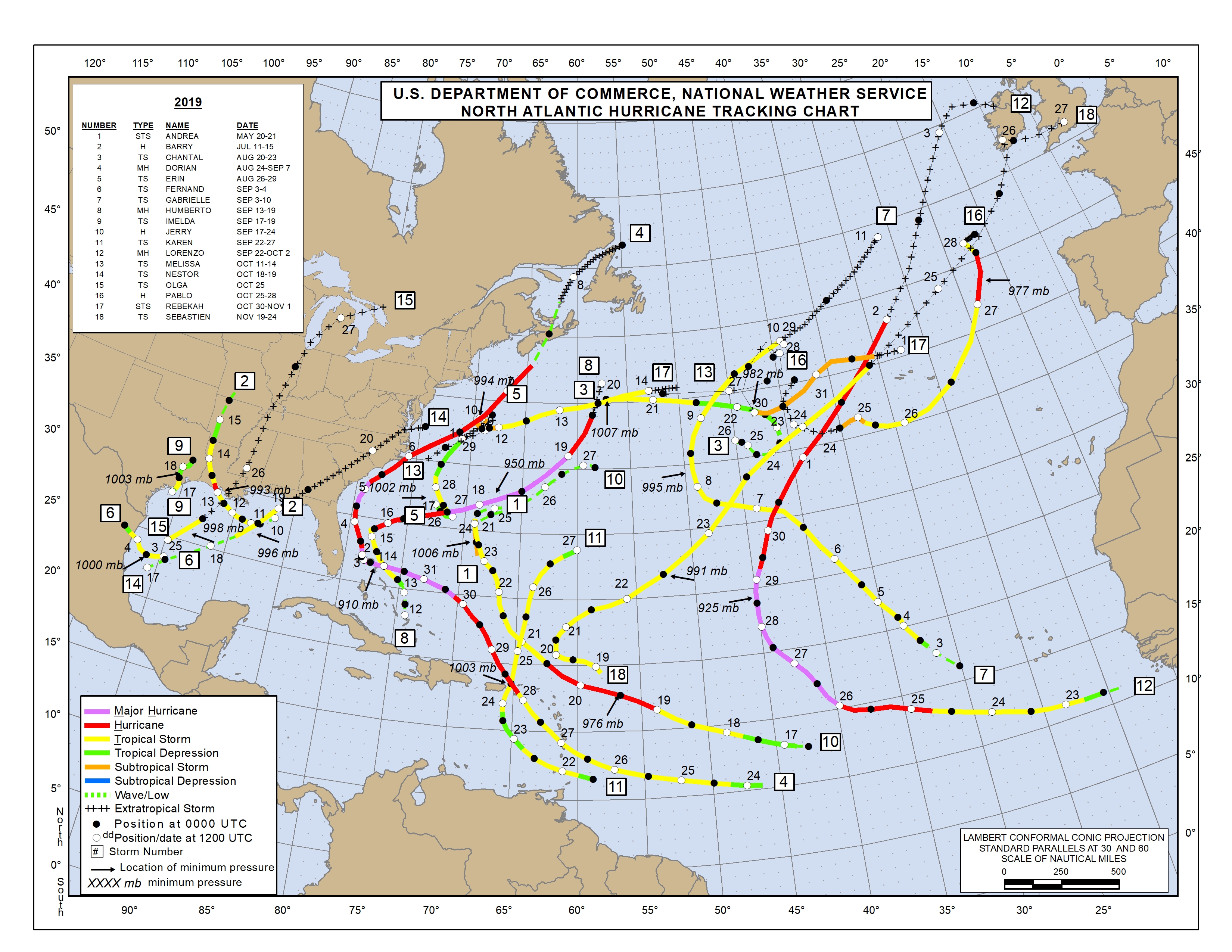
- - Source: National Hurricane Center (click on image for larger s
ize) - -
Weather discussions by Gert & Dave during the 2019 Atlantic Hurricane Season. The homepage with the links to local reports from the islands, latest satellite image, current weather outlook can be found here.
Sunday, March 8, 2020 09:04AM PDT - Surfers, get ready!?
- The following was forwarded to me by Ann Phelan, she was a long-time correspondent for Bonaire, about big waves coming to the Caribbean: Another Bomb Cyclone to Push Impactful Swells to the Caribbean (268weather/Dale C. S. Destin). Maybe post some cool pictures, but stay safe! -Gert
Tuesday, November 19, 2019 14:26PM PST - Earthquake Puerto Rico
- No storm in sight, but hurricane correspondents on Puerto Rico have been posting some updates, incl. pictures, on the recent earthquakes near Ponce. See here. -Gert
Tuesday, November 19, 2019 21:44PM EST
- #18 - 2019
-
Good night all,
It has been some season so far, this 2019 Atlantic Hurricane season, and as it draws to it's historical climax on November 30th after a prolonged period of weak, short lived systems, relative quiet, and the Azores taking the surprisng brunt of late season activity, Mother Nature says "It ain't over till I say it's over!". With that, TS Sebastien was declared from the seedling formerly known as 90L as of the 11am advisory, today November 19th.
Located about 300 miles NE of the Leeward Islands, Sebastien has been earmarked for potential development since Saturday. Asymmetrical in appearance due to strong westerly wind shear (20+ knots) shoving dry air into his tiny COC, Sebastien's convection is almost entirely on the eastern side of that COC.
Down the road, Sebastien is supposed to turn North then Northeast and be eventually absorbed by a cold front. Increasing in speed forward wise, he has the chance of increasing strength as well due to a lessening of wind shear, warm enough SST's, and baroclinic processes (which occurs in the form of wind energy from warm air rising and cold air sinking forming vorticity). Sebastien might reach 60-65 mph as an extra tropical storm before dying a rapid death in the North Atlantic. No land masses will be involved or impacted at this point.
Sebastien makes the total 18 named storms, 6 hurricanes with 3 intense hurricanes for this season so far. Above average activity yes. Will there be another one? Maybe. Sounds like alot but 8 or so of these storms were short lived with not much impact on land masses; only theÂname score.
Have a good night everyone!
DaveÂÂÂ
Tuesday, November 19, 2019 14:26PM PST - Sebastien
- One more named storm (hopefully) before the end of hurricane season. Sebastien, storm number 18 for this year. Although only about 275 miles from the Leeward Islands it is no threat to the islands. The system is currently moving north northwest, and might get a bit closer to us, but then it will veer off to the east. Hopefully the last storm until June 2020!!! -Gert
Monday, November 18, 2019 07:56AM PST - Possible something?
- Hurricane season is almost over, but we have an invest a few hundred miles east of the Leeward islands. There is a 50% chance that it could become tropical storm Sebastien. Luckily is is not moving towards the islands, but more north. Also, even if it becomes a tropical storm it will be (another) short lived storm. -Gert
Wednesday, October 30, 2019 14:30PM PDT - Another one!
- The season is not over yet. Another tropical storm named Rebekah. Similar to Pablo it is far out. And 38N, far north as well, about the same latitude as Lisbon, Portugal or Washington, DC... Rebekah is not expected to strengthen much, however it is moving towards the Azores, so might cause some squally weather over there. -Gert
Friday, October 25, 2019 16:17PM PDT - Two Storms!
- And this late in the season we all of a sudden have two tropical storms, Olga and Pablo! Olga formed in the Gulf of Mexico, but won't be long lived as it currently is merging with a cold front. It can still cause significant rainfall though along the Gulf Coast and more inland. Check your local forecasts if you live in the affected area. As for Pablo, it is also won't be threatening the Caribbean. It is far out in the Atlantic, moving 'the other way'. It might affect the Azores though. -Gert
Saturday, October 12, 2019 06:33AM PDT - Melissa
- And here we have (sub-)tropical storm Melissa. Sorry, I have not really been keeping track since I arrived on St.Maarten/St.Martin last week (more on that below). Melissa is not a threat to the Caribbean or Bermuda. There are 2 other areas that are being watched, in the southwestern Caribbean Sea and a wave that came off the African coast. Both are unlikely to become anything.
This is the first time I am on the island since Irma (2017). The stories people tell us who went through the storm (and aftermath) are pretty scary. But driving around the island I have been very pleasantly surprised how good the island looks now. There are still some areas where they haven't start rebuilding, like when you drive from Mullet Bay to Cupecoy (Ocean Club, next to Sapphire) and some places on the French side. Orient is now looking good as well, though some places still need a lot of work. Rebuilding on the French side is more difficult because of new rules set in place by the government. The vegetation looks very good. The island is very green. It's a bit warm here today, not much wind, the sea is looking very calm. Time to go swimming at Friar's. -Gert
Wednesday, October 2, 2019 09:57AM PDT - Europe
- With Lorenzo aiming for Ireland, I added a list of some cities in 'coastal' European countries to the closest point of approach tool. Never thought I had to do this. Closest approach with Dublin, Ireland is only 6 miles on Friday. Winds at that time are still expected to be tropical storm force! -Gert
Tuesday, October 1, 2019 18:54PM EDT
- Quiet, for now
-
Good evening all,
While hurricane Lorenzo races off to a quick date with the Azores (whose wind field is quite prodigious), then to raise havoc with the western coasts of Ireland and the UK, the Caribbean, GOM, and tropical Atlantic are pretty quiet considering the mayhem and chaos of the majority of September. However,.....
October historically, is home to the second "peak" of hurricane season and has been the home of many destructive storms throughout time. Currently, we have a few areas not quite of intense interest to receive an invest designation from the NHC but a % has been assigned showing potential, yet minimal. One is to the east of the Yucatan Peninsula and another is to the north of Hispaniola, both receiving only a 10% chance now through the next 5 days as of now. That can and will change but it's not certain yet which direction that change will entail.Â
Off to the east, we have a few weak waves but the ones that have caught some models attention are still over land that is the African continent. I shared previously the next three weeks could be quite interesting but hoped to be on the wrong side of interesting as in almost boring but with some rainfall. The waves that will be rolling off the African coast will really not get going, if they do, until they pass say 40-45 degrees west with a strong possibility of a mainly westward movement due to a strong ridge forecast to develop and block any thoughts of OTS treks aka fish storm movements.
Now is not the time to let your guard and vigilance down. We still have 8 weeks officially to go.
Be safe, vigilant and prepared!!
Dave
Thursday, September 26, 2019 21:08PM EDT
- Whats gonna happen next?
-
Good evening all,
Kinda quiet around the Caribbean for the time being with TS Karen wreaking some damage and flooding from Trinidad & Tobago to Puerto Rico and the Virgin Islands while looking nothing like the classic form of a tropical storm. Cat 4 Hurricane Lorenzo, on the other hand, is classically formed and fortunately, not a threat to land masses at this time.
Karen: Hmmm tough to figure out from the get go, still TS Karen has now left the hot Caribbean confines while still heading NNE towards Bermuda. But, there's a huge chance she won't have a date with Bermuda, the oldest British self-governing territory with it's first parliament held in 1620. Also, the brunt of many storms throughout the years due to numerous recurving tropical systems and it's location in the Atlantic, Bermuda is well prepared, a testament upheld by the recent landfall of hurricane Humberto.
TS Karen is forecast to stall and meander, do the loop de loop as a strong high pressure ridge blocks her NE escape route, lose intensity and head west towards the Bahamas and Florida as a possible TD, a remnant low or even a strong open wave. There is no mention of Karen being able to fight much longer against increasing wind shear and dry air intrusion. However, we have seen systems fight the battle and win the war. Karen needs to be watched until she poofs. If she does win the war there will be little warning time. This is not a crying wolf, just a possibility however remote.
Lorenzo: What a monster already, rare in the Central Atlantic. Again fortunately, expected to take his 700 mile wide in diameter self, aka akin to Hurricane Luis in 1995, away from any landmasses, he is taking advantage of a weakness between two high pressure ridges. That is the scenario at this time. That also is a lucky weather break for the Caribbean, GOM and the mainland. The Azores however, might have to contend with a semi rare visit from a recurving major hurricane downgraded to a Cat 1, dangerous nevertheless, especially with a huge wave and surf buildup on approach.
The GOM is quiet which might not be so in October while off to the east, the wave train still rumbles albeit a bit bereft of activity. A break was inevitable but the next 3 weeks harbor still to be realized possibilities.
Stay safe, vigilant and prepared!
Dave
Tuesday, September 24, 2019 20:37PM PDT - Karen+Jerry
- Karen is back to tropical storm strength. Though the rain is still the biggest factor. Currently the center of convection is over Puerto Rico where it is expected to dump 3-6 inches of rain, locally it can be even more. So that means that there is a great chance of flash floods and mudslides, esp. in the mountains.... Dave texted me (he has no power, so unfortunately he is no able to write his update) that on St.Thomas it is gusty, but little rainfall. There is no curfew but the seaports are closed. Big seas on the south side. Hopefully we will hear tomorrow how Puerto Rico has fared. Its path after it passes the islands is still kind of up in the air. Let's not get too concerned about it at this time.
Meanwhile, Jerry is still tracking slowly towards Bermuda. It is still a tropical storm but doesn't look like much anymore on satellite images. However, don't underestimate this storm too much, conditions will still be pretty gusty and locally there can be significant amounts of rainfall. Bermuda is under a tropical storm warning.
Lastly Lorenzo, the strongest storm of the three, and the one that might actually reach major (Category 3) status. Fortunately it is still forecasted to be a fish storm, staying over 1000 miles away from the islands. -Gert
Monday, September 23, 2019 20:55PM EDT
- TD Karen and others
-
Good night all,
As TD Karen approaches Puerto Rico and now, to a lesser extent, the US and British Virgin Islands, after flooding parts of Trinidad and Tobago, vigilance and preparedness guards should still be up. As Gert shared earlier, the winds will not be the issue, with the exception of those still sadly under blue tarps after 2 years past Irmaria. While the squally winds of a 35-39 mph tropical depression could do minimal damage, the heavy rains can. This includes flash flooding, mudslides, road washouts, power outages and potential death by drowning to those stupid enough to drive in flooded waters. Those people also put first responders in jeopardy of their lives for being selfish. Look up in Texas after Imelda.Â
Once a hot mess of a tropical storm, Karen is holding on for dear named life as she is being gut punched by relentless wind shear and the outflow channel wind shear assist from TS Jerry to her almost due north, resulting in her high top convection being blown away from the center and driving in dry air. This wind shear was expected to die down earlier resulting in a stronger Karen at this time but obviously that did not happen which is good news. As this area is known as the graveyard of the Caribbean for tropical systems due to constant wind shear, it's amazing she has held on. If the wind shear wasn't present folks, we would probably have a Cat 2 or 3 reminiscent of hurricane Marilyn circa 1995 on approach. Still, Karen could rejuvenate into TS status quickly if that wind shear takes a break.
That being said, the Governor of the US Virgin Islands has closed the Government and schools at noon today and all day tomorrow. Tomorrow night or Wednesday he will determine when they will reopen. Sandbags were distributed in a peaceful yet almost mile long traffic jam as mentioned by Jane Higgins which snarled Crown Bay traffic complicated by school and government being let out at the same time. 18,000 sandbags were distributed for Dorian. I wonder how many for Karen. The Governor did not institute a curfew as customary, rather take a wait and see how the people respond to his pleas to stay off the roads. From experience, many will not heed those pleas.Â
With Karen speeding up, it is hoped she does not dally long over Puerto Rico, still reeling for hurricane Maria. The last thing PR needs is a heavy rain event. All those conditions I mentioned above are probable so if your in PR, please take shelter, be safe, stay off the roads, and watch out for your neighbors.
I'll discuss Karens next move after her uninvited appearance through PR and all the Virgin Islands in my next post. A bit of last attention to TS Jerry who is going to visit Bermuda on a much lesser scale than his cousin Humberto did recently. TS storm warnings are up along with high surf advisories. Jerry should basically be a large nuisance to Bermuda but still, any TS is potentially dangerous.
TS Lorenzo is on the prowl heading almost due west with his expansive self and is headed quite likely to major Cat 3 status or higher. Most models have Lorenzo as a hurricane on Wednesday and recurving out to sea as a fish storm. However, each successive run keeps edging Lorenzo further to the west before recurving which is causing some skittish eyes along the east coast. If he gets under that high pressure ridge before recurving, things will get very interesting in 7 days.
One last bit, a swirl just north of the Yucatan Peninsula has a slight chance to develop in the Bay of Campeche. It should run out of time before affecting the Mexican coast as anything named or significant intensity wise.
Be safe and prepare!
Dave
Â
Monday, September 23, 2019 09:09AM PDT - J, K, L...
- Three named storms, luckily none a hurricane. Jerry is still hanging around after it passed the Leeward Islands on Friday. It doesn't look like much, and very a-symmetrical with almost all of its convection on the right (east) side of the center of circulation. Despite its sheared state Jerry is still a tropical storm and is expected to remain one for the next 5 days. The center is expected to pass about 60 miles west of Bermuda on Wednesday. With all the convection on the Bermuda side it will be a squally day. Having just cleaned up from Humberto, this one will make another mess, but it shouldn't be too bad. A tropical storm warning is in effect for Bermuda.
Then we have Karen, a bit of a surprise storm. I thought it would pass as a tropical wave over the islands, but was upgraded to a tropical storm. Not that it made a big difference since the rain, not wind, was the biggest problem, esp. on Trinidad. See the reports by the local hurricane correspondents on the islands on the right side of the page. As of now the forecast shows that it will pass over Puerto Rico tomorrow as a weak tropical storm. This storm doesn't look great either. The Hurricane Hunters who investigated this storm earlier today had a hard time finding a closed center of circulation. It might even fall apart in the 'hurricane graveyard' of the East Caribbean Sea before it reaches Puerto Rico. Here as well it doesn't really matter if it is a tropical storm or tropical wave, the heavy rainfall, which can cause flash floods and mudslides, not wind, will be the biggest problem. Tropical storm warnings are up for Puerto Rico, USVI and BVI. After it passes the islands it is not expected to curve out to the east, like traditional storms, but it might make a sharp turn to the west and even threaten the Bahamas. So stay tuned for this one!
Finally we have Lorenzo in the far eastern Atlantic, about 2500 miles (!) east of the islands. This one might actually become a hurricane in 2 days or so. Fortunately it still looks like Lorenzo will curve nicely north before reaching the islands. -Gert
Sunday, September 22, 2019 09:01AM EDT
- TS Karen
-
Good Sunday morning all,
Lurking far to the south while hurricane, now TS Jerry commanded the spotlight, 99L quietly crept across the Atlantic with not much to show for itself as an impending named storm until this early this morning. This very ragged mess was found to have a closed circulation and is now TS Karen, the 11th named storm of this busy tropical season.
TS Karen is now located just to the north of Tobago and is dumping heavy rains with major flash flooding ongoing at Scarborough, Tobago and other points on this small island while moving WNW at approx. 9 mph. Her TS force winds stretch out close to 125 miles but not in all directions as this is not the picture of a classic tropical storm. In fact it is quite the mess right now. See to the right of this screen and you can click on reports from our all volunteer network from all the islands being impacted now and down the road as TS Karen is expected to make a NW then NNW turn and make a beeline for Puerto Rico, the BVI's and the US Virgin Islands.
Once entering the southeastern Caribbean and making the expected turn due to a weakness left behind by Jerry, strong wind shear will continue to be Karen's kryptonite as she moves up the western side of the windward islands. While not strengthening quickly, her TS force winds and heavy rains will still reach many of the islands necessitating more tropical storm watches and warnings with watches expected to be posted for the northern Leewards tonight. This will also cause rip currents and beach erosion on the pristine and usually protected western facing beaches of these beautiful islands.
Forecast at this moment to still be a weak but slowly intensifying TS by the time it reaches the northern Leewards on Tuesday, I myself would prepare for a possible Cat 1 hurricane as the wind shear is forecast to weaken considerably plus an anti-cyclone (a large scale circulation of winds around a high pressure system) is forecast to form over Karen which would assist strengthening due to improved outflow or ventilation channels.Â
After Karen passes the islands, it's northward trek will be in danger; so will the US East Coast. A strong high pressure ridge is expected to drop down and force Karen to stall, the abruptly turn to the west which makes the Bahamas, Florida and the GOM entrants into Karen's plans. At what point she turns, if at all, and how intense she will get, remains to be seen. The T&C, Bahamas, SE coast and even the GOM should be wary of this one.Â
TS Jerry is still lumbering along but is expected to pass to the north of Bermuda late Tuesday. Jerry looks stronger on satellite imagery and I wouldn't be surprised if he regains minimal Cat 1 strength one more time before visiting the North Atlantic graveyard.
Off to the far east, 90L, just off the coast of Africa looks to be the 12th named storm of this season and that will be Lorenzo. Strengthening quickly, 90L should be either a TD or probably named Lorenzo by 5pm or 8 pm tonight. This system had strong model consensus for development while it was still several days over land. I doubt it will let them down. Forecast to become a hurricane and possible a major, it is fortunately supposed to become an OTS (out to sea) or "fish storm". Let's hope so. Right now the Cabo Verde Islands will receive it's rainy wrath.
Septembers not even over yet and we will have 12 named storms already with 69 more days to go officially in the 2019 Atlantic hurricane season. For now though, we watch Jerry and Karen with wary, vigilant and apprehensive eyes.
Be safe and prepared!
Dave
Friday, September 20, 2019 14:02PM PDT - Jerry and more
- Jerry looks a little better than earlier today, but it doesn't look like a 'nice' hurricane, which is good! See this loop (pop-up, same as above in the tool section) for example. Winds are 80 mph, so 'just' a Category 1 hurricane. Current location is about 120 miles from Anguilla, 136 miles from Barbuda and 130 miles from St.Maarten/St.Martin, near their closest point of approach. The islands should be well out of hurricane force winds, but might experience tropical storm force winds, so expect gusty conditions as the storm moves by tonight. Judging from the advection south of the storm (see satellite picture above), the rain might be the biggest problem with this storm. Right now it is moving forward at a nice clip of 18 mph, so it should be over soon for the Leeward Islands. Read the latest reports by our special hurricane correspondents by selecting one of the islands from the list on the right. Currently the forecasted track takes it really close to Bermuda, that is still cleaning up from Humberto's brush. Current closest point of approach is only 5 miles (!) on Wednesday... Hopefully the track will change a bit in the meantime. It is expected to be a weak hurricane by then, but you never know with these intensity forecasts.
Elsewhere, the blob near Hispaniola is still there. It doesn't look like it going to become a tropical cyclone, but it has been dumping rain for a few days now in the Dominican Republic and Haiti, which can not be good. But I haven't heard any worrying stories from that region, so maybe it is not too bad...
Then there is Invest 97L east of Barbados, that one is expected to move quickly over the Windward Islands (down south) this weekend as a tropical wave.
Finally, the NHC is mentioning potential development of a tropical wave that is still on the African continent, giving it a 70% chance to develop into something in the next 5 days... Pretty scary you'd think. However, both the GFS and ECMWF show it veer north well before it reaches the islands. Hope that holds true! -Gert
Thursday, September 19, 2019 19:02PM EDT
- The next few weeks +
-
Good evening,
While most of this year has sped along, the month of September has been dragging it seems as it's only September 19th. The tropical activity has been everywhere and looks to continue for the present and the immediate future to come.
Last thoughts on Imelda: In SE Texas, according to Chicken Little, the sky is falling, literally. Unconfirmed reports of up to 43 inches of rain has already fallen, the airport is inaccessible, tornadic activity is probable,Âflooding is rampant and now it's "rush hour" with people driving in the flood waters, and it looks on satellite and radar that a piece of the remnants of Imelda has broken off and is trying to get back out over the GOM. This isn't going away soon. Days ago, Imelda was almost a rainmaking afterthought and now, her name might even be retired and she wasn't even a name a whole day. So far one death has sadly been reported by electrocution. She is definitely taking it to the streets.
Last thoughts on Humberto: More damage than originally imagined was experienced by Bermuda with about 80% of the island without power but no injuries or fatalities at this point. See the Bermuda post to the right, click it and open the pictures sent. Humberto has a date with Europe so goodbye. More on Bermuda in a moment.
Hurricane Jerry has now made Cat 1 status but is reaching for more as strengthening appears to be continuing but with a short window. I believe he is a Cat 2 already. Hurricane Hunters have a flight scheduled later tonight and will have the details in the morning. More symmetrical now, Jerry's hurricane force winds stretch 25 miles outward and TS force winds stretch out about 80 miles. The center is currently located about 450 miles to the east of St. Eustatius, Jerry is moving about 17 mph to the WNW and is expected to continue this track with a slightly slower forward speed ahead. This bodes well for all the Leeward Islands meaning no land falling Jerry.ÂNevertheless, rough surf, rip tides, gusty winds, and squally rains will prevail especially in Antigua and Anguilla who will probably feel some TS force winds at some point.
I must state the obvious: This track, while well forecast and depicted by the models and forecasters, is not 100% stone. A few hours deviation to the west or even SW could change things dramatically, not only for the northern Leeward Islands, but down the road, the Bahamas since re curvature has been forecast to occur well before reaching them. Another possibility, albeit quite remote, is Jerry strengthens quicker and stronger, misses the re curve and goes GOM. While remote, the possibility is there. Bermuda, as you clean up after Humberto, keep a wary eye on Jerry.
Several others continue to be in the mix. The system that is just south of the DR and Haiti will continue to dump copious amounts of rain while moving generally to the WNW. Chances of development are minimal due to interaction with land and wind shear but flooding is a definite possibility.
Along 43W, we have a wave that should show some signs of development over the next few days but might just be aÂstrong wave or a TD as it arrives in theÂWindward Islands giving Barbados a two cheek kiss as it passes by.
The next two waves that will come off the African coast will bear some interest as conditions by then should improve on the development scale, not that they are bad now by any means. Until the end of October, really, anything that comes off AfricaÂbears watching.
That's it for this moment in time. Let's hopeÂthe remnants of Imelda stop trying to drown SE Texas, Jerry doesn't hit the Leeward islands and re curves without hitting anyone including Bermuda, and the rest of the waves stay just that: waves. Is that too much to ask for? Probably but we hope for the best and prepare for the worst.
Be safe, vigilant and prepared.
Dave
Thursday, September 19, 2019 08:00AM EDT
- Threats everywhere
-
Good morning,
Active continues to be the main adjective at this time with the Eastern Pacific getting in on the action along with our imposing Atlantic lineup. With more waves crossing Africa, as is customary at this time of year, active will continue to be ongoing.
Humberto the Humongous: Now this Cat 3Âis a huge system which has affected Bermuda as it raced by overnight. With hurricane force winds out to 90 miles and TS storm force winds stretching out an astounding 405 miles, it remains to be seen what damage was inflicted on this well prepared island nation. Fortunately, Humberto passed well off to the north and was spared the hurricane force winds but even TS storm force winds can and probably did inflict some damage. Hopefully all is as well as it can be there with no loss of life.
TS Jerry: Menacing the Eastern Caribbean, Jerry looks a bit ragged this morning but has continued to strengthen and reach hurricane status soon. Located about 525 miles from the northern Leeward Islands, this intensity should be held in check by rising wind shear allowing dry air intrusion thus not allowing Jerry to strengthen even though over more than warm enough waters. TS warnings are up for most of the northern Leewards and I expect hurricane watches to be posted once he is upgraded.
Jerry is not expected to make landfall in the Caribbean according to the models and forecasters who are in really good agreeance. Any deviation south or large wobble however, brings the possibility it would. While this right now is highly doubtful, until it passes, the chance remains so vigilance and preparation need to continue to be followed. Use the tools available to you under the map to get an idea of the closest point of approach to your position. This gives a great picture of, if Jerry continues on this path and speed, where he will be closest to you and how far away. Once past the Leewards, Jerry is expected to make a hard right turn and miss the Bahamas, who do not need any more storms, and menace Bermuda around Tuesday night into Wednesday on a more southerly track then Humberto. Lets hope Jerry turns on cue, misses the Bahamas, and flies under the Bermudian radar south.
What was short lived TS Imelda is dropping almost Harveyesque like rains on SE Texas and flooding continues as does the slow moving rain asÂa tropical system of this sort classically does.
We do have a few more waves out there. One, just to the SE of the Dominican Republic has waxed and waned and has limited potential due to the upper level winds but is expected to produce copious amounts of rain over the DR and Haiti. The other, about 1000 miles to the west of the Cabo Verde Islands does have potential down the road. Current thought is it will trek almost straight across and enter the Windward Islands as a TD or weak TS. AÂstrong ridge might develop a weakness several days from now which would allow this wave to gravitate NW, graze the northern Leewards and go out to see. Too early to tell though and per usual at this time of year, everything needs to be watched!
That's it for now. I'll have an up date sometimeÂlater today or tonight. Be safe and prepared!
Dave.Â
Wednesday, September 18, 2019 15:32PM PDT - Humberto and Jerry
- Hurricane Humberto is nearing its closest point of approach with Bermuda, about 90 miles. Humberto is a major (Category 3) hurricane, packing 120 mph winds. It has some spectacular outflow to the northeast (see image below, showing Humberto's closest approach relative to Bermuda). Hurricane force winds extend about 80 miles outward from the center, which seems just out of reach of the island, however, sustained winds of 75 mph (= hurricane force) have already been reported on the island, with higher gusts. Houses on Bermuda are very well built, so they should come out ok. I still am trying to get some reports from my correspondents on the island, so hopefully we'll have some first hand reports soon.
Then we have now Tropical Storm Jerry (was Tropical Depression 10). Right now it still looks like it will pass about 100 miles to the north of the Leeward islands on Friday. By that time Jerry is expected to be a Category 1 hurricane though. It is a bit hard to forecast the intensity of this storm, although the water is plenty warm and there is light wind shear, there is very dry air around the storm. In 2 days wind shear is expected to increase, so the storm might weaken again later.
Most models are in pretty good agreement that the center of Jerry will stay north of the islands. However, a little wobble south can make a big difference. Most likely the islands will be out of range of hurricane force winds, but with tropical storm force winds extending outward about 90 mph at time of passing, it is much more likely that the islands will feel at least tropical storm force winds (39mph and up). Indeed, tropical storm watches have already been issued for St.Maarten/St.Martin, St.Barths, Saba and Statia, with Anguilla probably soon to follow. Stay tuned... -Gert
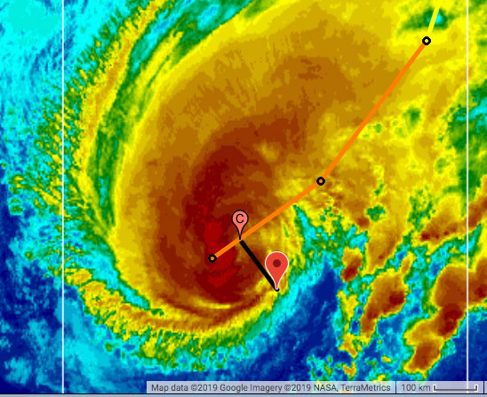 |
| Closest Point of Approach Relative to Bermuda |
Tuesday, September 17, 2019 18:06PM EDT
- The Terrible Threes
-
Good evening from Allentown Pa,
This is where I am as my girlfriend recovers from her latest burn surgery. She is doing well so that is awesome. Weather wise, here in Allentown, not a cloud in the sky, low humidity, and beautifully sunny. But we are not here to talk about Allentown. It is real pleasant though.
What is not pleasant is Bermuda is now under a hurricane warning courtesy Humberto the Humongous. From it's Hurricane force winds stick out 60 miles from the center with tropical storm force winds outwards of 175 miles. Humberto is forecast to actually reach Cat 3 status for a short lived, statistically added time. Bermuda is a well defended island from tropical systems. However, coming from the east presents a different set of issues. Regardless, they should "weather" Humberto's impacts with an experienced hand comparatively speaking.
TD 11, now very short lived TS Imelda, has pushed into Texas already with flooding already occurring around south Houston and other areas and this is expected to continue as Imelda slowly makes her way into the heart of Texas land with western Louisiana getting popped as well. A TD as of the 11am advisory, classified a TS as of a special advisory at 12:45 pm, and making landfall at 1:30 pm, Imelda made the most of a very short lifespan while traversing the GOM as a low from off the coast of Florida to the Mexican border. Most of the convection is on the east side hence the flooding raging through southern Texas and not the western portion of the system. The upgrade from TD to TS does not really affect the consequences as a 5 mph higher designation doesn't change much effects wise, only scientific designation statistical wise. This will be a bad time of flooding in the concrete city of Houston and surrounding areas.
TD 10, located about 1470 miles SE of the northern Lesser Antilles, has changed little in the way of organization today but will be entering an area very soon with higher SST's, low to moderate wind shear and a lack of significant dry air/dust. Expected to become a TS overnight tonight, soon to be Jerry will start picking up forward speed and be on the northern outskirts of the Leeward Islands by early Friday morning. Expected to keep on that NW track, Jerry should pass by with just some rains, gusty winds, rip currents, and some northern beach erosion.
More tomorrow on Humberto, Jerry and beyond. Bottom line is Humberto could make a direct hit on Bermuda and soon to be Jerry can sink just about 150 miles to the south and make a direct hit on the northern Leewards. This is models and forecasts talking with what they see is probable and possible. Margins of error exist so be vigilant as changes happen each run.Â
Dave
wind shear and lower dustÂ
Tuesday, September 17, 2019 14:16PM PDT - Three Storms
- All of a sudden we have three storms, one tropical depression, one tropical storm and a hurricane. Let's start with hurricane Humberto first, currently a Category 1, with 105 mph max. sustained winds. It has become a pretty large storm, with tropical storm winds extending outward up to 175 miles and hurricane force winds 60 miles. As it looks right now (and forecasts have been pretty consistent over the last day or so) the center will pass about 100 miles to the north of Bermuda in about a day. At that time it is expected to have strengthened into a major (Category 3) hurricane, so Bermuda might feel hurricane force winds. Most models are in pretty good agreement that it should stay north of the island, but still, it is a bit too close for comfort, so be prepared Bermuda! A hurricane warning has been issued for the Rock.
New tropical storm Imelda will be pretty short lived. It just made landfall near Freeport, Texas (not Bahamas!!!), which is near Houston. Imelda actually was upgraded to a tropical storm when it was over land, so after landfall... It will produce a lot of rainfall in the Houston area, although it is moving at about 7 mph and is not expected to stall. However, this region that does not always cope will with a lot of precipitation as we have seen in the past...
Finally, the tropical wave we have been watching for a while has been upgraded to Tropical Depression Ten. It will reach the islands in about three days. Earlier it looked like it would be nicely bending to the north, but now it looks a bit closer. However, it should still stay about 100 miles away from Anguilla for example, but in those three days time, forecasts might trend further south. But so far, squinting at the spaghetti model plots of then 'Jerry', it looks like that it should stay north of the islands. At the time it passes, this system might have strengthened into a hurricane ('just' a Category 1). So we have to keep a close eye on this one. I don't want to speculate too much on where it might go after that, but let's all just hope if will curve to the north well before it reaches the Bahamas... -Gert
Sunday, September 15, 2019 07:19AM EDT
- Slow down of sorts
-
Good Sunday morning,
TS Humberto is still lumbering along north of the Bahamas, east of FloridaÂwith his tail still lashing parts of the central Bahamas all the while looking like an angry parrot since he is having trouble closing off his SSW and SE side due to the relentless wind shear from the system in the eastern GOM. This however, is lessening and Humberto the Hurricane will be born soon. I wonder if the ugly duckling, pretty swan story will play here as Humberto is one ugly tropical storm. Â
Fortunately for the NW Bahamas, that wind shear has protected them from Humberto adding to the misery caused by cat 5 Dorian. The last thing they need is another tropical entity overhead. Now pulling away, he is headed for a possible interaction with Bermuda as a borderline Cat 3 but there is a lot of ocean to cross first.
The GOM possibility west of Florida is fizzling and the models are not bullish on tropical formation but heavy rains and gusty winds along the gulf coast will ensue, especially in Texas later this coming week.
96L is no more. A victim of his own speedy road runner actions plus a healthy dose of late season Saharan Dust, led to an early demise. He even collected the non invest that was just behind him but adding to his arsenal was a failure which is great news. Rains and gusty winds will be entertained by the Lesser Antilles and Windward Islands but that should be it's final act. The possibility of regeneration after entering the Eastern Caribbean is remote but not completely out of the question.
The next candidate is an elongated tropical wave which is so broad in nature, it would take a few days to get it's act together and that is what the models are suggesting. Possible 97L could make TD status in about three days but is forecast to become a fish storm, passing several hundred miles to the NW of the Lesser Antilles. Let's hope so. "I" storms are notoriously bad.
One new wave just splashed down and several are still marching across Africa. The next three weeks, especially at the end of the month, look to be quite active which is reasonable considering we still have 1/2 a hurricane season to go. Stay vigilant!
Dave
Saturday, September 14, 2019 13:45PM PDT - Humberto
- The center of now tropical storm Humberto is passing just to the north of Abaco now. Fortunately not over Abaco or Grand Bahama. Tropical storm winds could be felt on the islands, but the worst windwise should be over. There is quite a tail, and depending on the timing of the rotation and location of the islands, a lot more rain might be falling, or not much more... It could have been worse with this one for the Bahamas, but still no fun when you house structure is compromised already, or just don't have a roof, or worse, no house at all. Again, help is still needed. Check out the Bahamas reports page for places to donate!
Bermuda should pay attention to this storm as well. It might pass pretty close as a hurricane in 4 days or so...
Elsewhere.... we have a few waves in the Atlantic, of 96L being the most noteworthy, still far out, but it could become the next named storm. The GFS and ECMWF model shows that it will turn north enough to not affect the islands. Stay tuned... -Gert
Friday, September 13, 2019 21:08PM EDT
- Lots
-
Good evening from sultry Florida,
We have several short discussions to ponder tonight. The good part is none of them are angry, evil, well defined tropical systems at this time. The bad part is all 4 of them could develop and be impactful, nasty systems or none could develop at all. The latter is what we hope for. The former is probably not going to happen but it is September, peak hurricane month of the tropical season. Lets hope TD#9 is the only one out of those 4 that manifests it's destiny.
TD#9: Soon to be TS Humberto, it is menacing the Bahamas and threatens the same portions of the NW Bahamas as devastating, lumbering Cat 5 Dorian did just a short time ago. The last thing these islands and those surviving need is another direct hit. Some fresh rain would be good for some though. Good news is most of the convection is on the far eastern side of the poorly defined center of circulation. This would spare those most impacted by Dorian. An exhale of relief was also heard by the east coast of Florida as the center was found by the hurricane hunters to have formed more north and easterly than satellite fixes, thus moving the dreaded cone of uncertainty to the north and east. Let it be known though the cone has margin of errors and Florida is really not out of it yet. Down the road, Humberto is forecast to do a "Right turn Clyde" and make a beeline for Bermuda, a storm weary, well defended and prepared veteran of numerous storms, a concrete jungle on an island in the Atlantic.
96L: Started out with vigor and serious intentions but has now been seriously battered by the Saharan Dust dry air attack. SST's are 82-84 degrees still and wind shear is pretty moderate but it still has not taken advantage of it's position, not only due to the dust, but it fast forward movement. That's good news. Look for probably gusty winds and heavy rains on Sunday in the Lesser Antilles. Now this doesn't mean it can't get it's act together down the road and will still be something to watch as they all are right now.
Soon to be 97L has emerged from the African coast with the same intentions as 96L but appears to maybe becoming a fish storm in a few days. Fast moving and not too healthy, it is still on the radar.
A disturbance has emerged weakly in between these two systems and does have a small chance of energizing but with the chaos in front and behind, it is doubtful. Still, the NHC has recognized it so something to be monitored.
The western GOM is quiet but the eastern GOM is not as a blob of thunderstorms and tons of lightning has popped up west of Tampa. Popped up by an upper level low, the one shearing TD#9, it does not appear to be a threat at this time. Maybe in a day or two it might.
It's busy people. Lots of action and areas of concern. Lots of bad possibilities. Look at what Dorian did. Was gonna die pretty much after interacting with the mountainous terrain of the DR, but, after a reformation of it's COC north of St. Lucia's encounter, it proved sadly deadly, costly and historic. Acknowledge the possibilities. Be prepared.
DaveÂ
Friday, September 13, 2019 09:44AM PDT - Number Nine
- The 'potential tropical cyclone' Nine is looking pretty impressive for not even a 'depression' yet. It is located just north of the southern Bahamas/Turks & Caicos. Unfortunately it is forecast to move over Abaco and Grand Bahama tomorrow. The forecast is a bit unsure, since the center is kind of hard to pinpoint, and it looks like a big mess. Also, tt hasn't been moving much recently, but hopefully it is going to move on before it is strengthening too much, and of course we don't want another storm stall above Grand Bahama, dumping rain!
Conditions will deteriorate later today when it is forecast to move closer to Abaco. It is expected to be a tropical storm (named Humberto) by the time it reaches Grand Bahama. People are of course still quite on edge. But this will by far not be an event like Dorian. However, there will be tropical storm winds and 1-2 inch of rain. Not fun when your house is in shambles... The only positive I see is that all the salt will be washed away from the island, which will be good for the vegetation. Stay tuned... -Gert
Wednesday, September 11, 2019 20:15PM EDT
- Humberto soon?
-
Good evening,
While fluffy, non threatening snow delighting snow skiers has fallen in Utah and Montana, closer to home, we have 3 areas of interest in the Atlantic with more tropical characteristics and possible evil intentions in mind although it's too early to tell a hard forecast for all.
95L: Mixing and mashing the Turks & Caicos and Southern Bahamas who were spared Cat 5 Dorian's wrath, it does appear to be slowly getting it's act together with a possible center point in the Turks and Caicos trying to gel with heavy thunderstorm activity flaring up. The SST's are 82-84 degrees and the upwelling from Dorian has virtually disappeared over the gulf stream while wind shear is diminishing rapidly. Several paths are possible for the taking with 95L as it is steered by a large, strong high pressure system to it's NE. One path is directly over the peninsula which sabotages it's efforts to strengthen thus relegating it to a heavy wind and rainmaker in the southeast. Might cool it down a bit due to the heat wave but destructive along the coast again beach wise. Another path possibility takes it over the southern edge or even through the narrow Straits of Florida and the Keys. This path could be very bad exponentially with RI possibilities due to low wind shear and extremely warm GOM SST's. On the other hand, it might not develop and just scare everyone jumpy from the recent Dorian experience. Regardless, heavy rain and gusty winds will prevail all over the Florida peninsula this weekend and the NW Bahamas, reeling from a direct, almost biblical strike from Dorian, will certainly entertain some of these effects. Hurricane Hunters have a mission scheduled, if necessary tomorrow. A TD is likely shortly and the next name on the list is Humberto.Â
94L: Was on then off now on again. While not having Phoenix like status, 94L keeps hanging around and when systems linger around long enough, something bad usually happens. In this case though, sloth like 94L should dissolve into history, maybe even being over by Mr. in a hurry, soon to be designated 96L. This weekend, expect some rain and blustery winds from 94L but not much else. Wind shear will be the coroners cause of death.
Soon to be 96L: Looking disjointed early on, this system has the many models and the NHC attention. Rapidly moving to the west, it is likely to develop in the central Atlantic close to the Windward Islands. Saharan Dust has disappeared pretty much as if on cue late September, moisture levels in the mid levels is around 60%, wind shear is moderate, and the MJO, (Madden-Julian effect first discovered in 1971), which circles the globe every 30-60 days will be present further enhancing instability. This system is quite broad in nature and once consolidated, could pose a long term formidable issue down the road. Watch this one folks and the one behind it.Â
There is a discombobulated mess in the Western GOM that might have a chance of development but the window is closing rapidly and northeastern Mexico looks to be the recipient of heavy rains again.
It's on so be prepared, be safe, make wise decisions, and check on your neighbors AND your pets. They are family too!
Dave
Wednesday, September 11, 2019 09:09AM PDT -
Waves
- No active storms! But we have some tropical waves. None are expected to develop into something threatening for us. First there is the wave close to the Turks & Caicos (Invest 95L). It is expected to move over the Bahamas. Rain and breezy conditions expected, nothing more. But people in the northern Bahamas are of course quite sensitive to the weather right now, and with no roof over your head it is not good... On that note, please see the Bahamas reports page for information on how you can donate to Abaco and Grand Bahama. Help is really needed! If you know of other great (efficient) charities let me know.
The other invest (94L) we have been following for a long time. It is still struggling to become 'something', and it is losing its battle with wind shear and dry air. So luckily no threat either. The last area of interest is a wave that got just off the African coast. Formation chances are also quite low, but we will keep following it of course... -Gert
Monday, September 9, 2019 20:37PM EDT
- Bye Dorian! Keeping an eye on the rest
-
Good evening all,
TS Gabrielle is on her final legs as she continues her North Atlantic jaunt along with Dorians remnants headed toward the UK. Gabrielle will be remembered fondly for being only a fish storm, once declared dead then resurrected. On the other side of the eight ball, Dorian will remembered for an initial under the radar TS, morphing into a quick hitting unforeseen hurricane over the VI, a sloth like, utter human catastrophic, terroristic existence over the NW Bahamas, menacing and schooling the Florida and Georgia coastlines, teasing and flooding the SC coast, finally making landfall "officially" on the NC coast with great flooding effect, and finally terrorizing Halifax and the rest of far east Canada. Now, a name retired. Goodbye Dorian.
Our neck of the woods still has prospects sadly. However, two of them seem benign. 94L is looking pretty ragged as it continues a westward jog. While wind shear and SST's are very favorable, a dry surrounding environment is not. 94L still has a window of opportunity but does not have the support of the weather judges, aka the tropic models. A rain maker and trouble maker at best at this moment in time.Â
The disturbance NE of Puerto Rico has promise as well but it's long term. In the short term, wind shear will be it's kryptonite but as it passes over the Turks and Caicos plus the southern Bahamas, it stands a small chance of development, like a TD, close to the Fl coast. It also has the possibility of getting into the GOM which poses a new set of issues too far in advance to ponder. Needless to say, a very wet weekend is in store for the Florida peninsula.
Now, to the candidate which might possibly rear it's ugly head in a week or so. The next wave in the seasonal train will exit the African coast shortly and with it comes some interesting, long term and dangerous possibilities down the road. Development in the MDR (Main Development Region), is very possible once it reaches the Central Atlantic. Long term models are hinting at bad interactions along the Lesser Antilles chain (from PR south to Trinidad and Tobago) and up to the mainland. Obviously too early to accurately forecast and pinpoint but we have been doing this a long time so I'm sure you understand the obvious at this point.
Bottom line. The race is on to see who becomes 95L and 96L shortly. Really doesn't matter if you are in the way. 94L might fall apart and might surprise so do not let your guard down as Dorian was a prime example. We have just over 1/2 of the official hurricane season to go and who knows what the other half has in store for us. Be prepared. Be vigilant. Do not be complacent or pompous. It's not worth your family's life or your own.
Dave
Â
Saturday, September 7, 2019 10:10AM EDT
- Goodbye Dorian Hello The Phoenix & Others
-
Good morning all,
I was going to write a post last night but our lovely utility, WAPA , aka What Another Power Anomaly among others I can't write here, was out for about 9 hours on my part of the island so by the time it came back, I was too sleepy to post. Now bright eyed and bushy tailed, here I go!
Long lived, terrifyingly destructive and deadly hurricane Dorian is finally moving to it's third country interaction, Canada, with Halifax looking to take a direct hit or close to it from Dorian's final days as one which will go down in infamy, especially in the Northern Bahamas where the final death toll may never be finite. It's legacy is destined to be enshrined in the halls of destruction accompanying Irma, Maria, Marilyn, Joaquin, Ivan and other Caribbean storms of the past. Now, on it's way to Nova Scotia and Newfoundland, Dorian is about to have a double date with Europe as a partner is re-emerging on the stormy North Atlantic set. Gabrielle.
Like the fictional, mythological Phoenix, Gabrielle was pronounced "dead" a few days ago only to rise again hours later and is now projected to be a hurricane, as was shared a few days ago, sometime on Monday. Late Tuesday, Gabrielle's double date to Europe partner, Dorian, will be in nautical shouting distance and looking to tag team the British Isles while menacing North Atlantic shipping lanes. Obviously, things can change in the next few days but this is pretty much in agreement.
94L. With the headliner of the last 10 days or so Dorian exiting the stage, 94LÂ has already made her entrance but looking a bit discombobulated as it treks across the Eastern Atlantic a few hundred miles west of the Cabo Verde Islands around 30W. Moving at about 15 mph with a 1011mb low attached, 94L will remain disheveled for the next two days or so due to dry air intrusion and lower SST's although it does have some flareup activity going on. Once in the Central Atlantic, conditions will ripen a bit with 82-84 degree SST's and low to moderate wind shear. The problem at the moment appears to be a dry environment which, even with the above positive conditions, will mitigate 94L's chances of developing sooner than later. That is good news as a slow developing system cannot take advantage of the earths rotation, aka Coriolis Effect enabling it to spin. When they spin, they tend to climb in latitude due to the earths rotation.
Models don't do well with forecasts this far out and definitely not with any that do not have any organization so we will have to keep an eye on this one and the one behind it. Right now they pretty much have 94L flat lined to the west for the next 5 days. Might get interesting after that. Also last few days of September, first week of October as well.Â
Be safe and prepared!
Dave
Wednesday, September 4, 2019 20:30PM EDT
- Conga line time
-
Good evening,
First, in a long time due to Dorian's extended life span of destruction, we will discuss what we really do here: Discuss the Caribbean. I will have some comments on Dorian at the end which will should regain Cat 3 status briefly tonight.Â
TS Fernand not to be confused with Ferdinand. Inland on the NE Mexican coast south of Brownsville, TX, Fernand is now a TD with winds max at 35 mph. Winds will not be the real issue with Fernand. Torrential rains on the mountainous terrain will result in serious flooding and mudslides. Fortunately, this area is not heavily populated. It's proximity to South Texas means 1-3 inches of rainfall, isolated to 6 inches with a random tornado possible in far Southern Texas. It will be an ex tropical shortly.
TS Gabrielle. located about 760 miles WNW of the Cabo Verde Islands, is traveling NW into the Central Atlantic as a moniker named "fish storm" only a threat to shipping lanes and the unlucky yacht or two. Forecast to actually attain minimal hurricane status on Monday, Gabrielle's only threat to landmasses will be in the North Atlantic with no Caribbean effects.
92L. Spinning about 220 miles to the NE of Bermuda will also not be a threat to the Caribbean and has basically a short lived 50-50 chance at TD status, less for TS status while it's claim to fame might wind up being a date with Newfoundland after Dorian visits, possibly with hurricane force winds still as an extra tropical powerful storm.
Farther east, just off the African coast, as if on cue, is our next system in the recent spurt of conga line entrants into the Atlantic. While the NHC has lowered their 5 day possibilities of morphing into something tropical from 70% to 50%, do not let that fool you into some sort of complacency. Soon to be 94L has a much moister environment across the MDR (Main Development Region), courtesy of Dorian which was shared as a possibility in a previous post, wind shear which will be low to moderate, and a lack of that protective Saharan Dust shroud. Upper level dynamics will be also favorable so it's very probable we will have a system which will pose a threat to the Caribbean in about 10 days then mainland or Bermuda. Too early to tell of course but the fine print is there. The next name is Humberto but TS Gabrielle might beat him to the punch name wise.Â
Now Dorian. Just a few more comments as the mainland media has overwhelming coverage. Dorian is just a mile or two shy from regaining Cat 3 status and the wind field is growing. Located about 124 miles south of Charleston SC, Dorian once again hasn't really listened and not turned NNE yet. This means increasing life threating danger, floods, tornadoes and storm surge to the SC and NC coasts. I think landfall is a very good possibility at the northern end of SC before it reaches Cape Fear as it hasn't started it's turn yet. Regaining Cat 3 is almost certain but really there is no difference between a high end Cat 2 and a minimal Cat 3.Â
Gert has established several tools and help forums for those in the Bahamas devastated by Dorian. Please help if you can. 65,000 people have nothing. 13K-14K homes obliterated. Much like PR after Maria in 2017, they will be resilient and rebuild but it will be a herculean task and last years.Â
Dave
Wednesday, September 4, 2019 09:54AM PDT - Bahamas
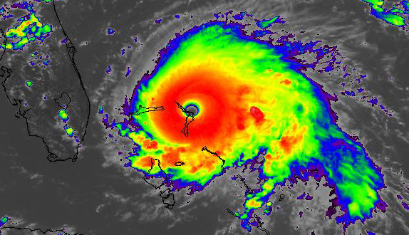
- It is very saddening to hear the stories and see the pictures and movies of the destruction in the Abacos and Grand Bahama. The death toll right now stands at 7, but I think will most likely go up now that can get a bit around on the islands. It was a nightmare scenario, first Dorian making landfall in the Abacos with unprecedented 185 miles per hour wind, and then stalling over Grand Bahama as a Category 5 for over a day... Unimaginable. People most be totally exhausted...
I am not getting that many reports from the Bahamas, with communications out, and people having better things to do. There is a Dorian People Search website set up, if you are looking for the status of your loved ones. They also have a list of local relief organizations where you could donate money to. I have set up island-specific Please for Help forums at help.stormcarib.com so people can communicate at a centralized location if need be. They do need our help!
So with Dorian finally gone from Grand Bahama, let's focus back on what is going on elsewhere... Three named storms, one invest, and one wave coming off the African coast. This must be peak hurricane season! Fernand just made landfall as a tropical storm just north of La Pesca, Mexico. Wind is not the problem here, but it will cause a lot of rainfall, possibly resulting in flash floods and mudslides. The advisories are indicating local rainfall totals as much as 18 inch! At least this storm is moving along well, and is predicted to dissipate in 24 hours or so. Still the rainfall in esp. the mountainous areas will remain a threat.
Then we have tropical storm Gabrielle, far out in the Atlantic. This one is not expected to become a hurricane. It is also moving northwestward and will pose no threat to us. Invest 92L is located just east of Bermuda, and moving away from there, so no threat either.
Finally, there is a tropical wave coming off the African coast. Dave mentioned it earlier already. This one also might become a tropical storm. Right now it is too early to tell if it will ever reach the islands. The Tropical Weather Outlook (see below) indicates that it will move westward to west-northwestward. Let's hope for a more northernly path so that it will bypass us. Stay tuned for more... -Gert
Monday, September 2, 2019 20:48PM EDT
- Of Course Dorian and others
-
Good evening all,
This might be a shorter report due to intermittent internet tonight as well as sporadic power fluctuations. Why, I do not know as it's calm, hot and muggy here in the USVI. But then again, it is where we live.
Now Cat 4 Dorian is a squatter, languishing over Grand Bahama while continuing to lash the whole NW Bahama chain of islands but moving zilch. That means stationary. Catastrophic damage has occurred and continues to happen. Officially 5 people are fatalities but I have heard from different sources at least 50 are feared dead and some will never be recovered. Very, very sad situation. The airport is totally consumed by surge which might reach the southern resort areas. Freeport has been battered all day and is now only 25 miles from the center. The only good news here is Dorian is expected to start a movement to the WNW, NW, the North then NE overnight and into Tuesday. Meanwhile, Marsh Harbour still is receiving squally weather, Abaco is virtually destroyed, who knows about the smaller cays and Nassau has experienced strong TS winds and an island wide power outage 100 miles to the south. Small cays and sandbars have disappeared as I shared earlier was possible. The geography of these beautiful islands have changed with a high price paid. When your islands have a top height of about 40 feet above sea level, and your storm surge is 18-25 feet in the lowest places, that doesn't leave much room for survival.
Stationary as Dorian is, the system is weakening. Down to 140 mph from 185 mph and pressure up 27 mb from 915 mb to 942 mb at the moment of this post, this is great news for everyone in the crosshairs. Sadly, that is too late for our Bahamian friends. The destruction and death toll will be evident soon. Gert has started 2 pleas for help forums for the Bahamas. There is also some private agencies ready to assist but conditions are too dangerous still to rush in. Dorian needs to vacate the premises and quickly.
Florida and the east coast to NC: Hurricane warnings, watches, storm surge warning and watches, tropical storm watches and warnings, coastal flood warnings and watches, severe beach erosion warnings and watches. That's the menu through Thursday. By Friday it might still be a hurricane affecting Nova Scotia, Canada. Weaker and forecast to slowly weaken more and do that turn everything has been pointing at, it appears it will stay off the coast of Florida a bit more than 12 hours ago. Still, even Orlando International Airport will shut down ops at 2am tomorrow in anticipation of TS force winds. Wow. As Dorian rakes the coast, winds will be an issue but it's the surge and flooding that will assume top billing. Please follow all directives from your local emergency management authorities. I've stressed this mucho the last few days. Your life is not worth your material life.
Correction from last night: 91L is not on the GOM heading towards Mexico but 93L is. Sorry about the fast fingers. 93L does have a chance for development but it will be short lived with heavy rains, flooding and gusty winds prevailing along with storm surge along the Mexican coast.
92L: SSE several hundred miles of Bermuda, it is not expected to develop. It might interact with hurricane Dorian which to this point, has not been discussed by the NHC or TWC. Regardless, appears not a threat.
The real 91L: several hundred miles west of the Cabo Verde Islands, it is forecast to at least reach TD status and might make a Fernand. Moving to the WNW then NW, it will fizzle as a fish storm unless other unforeseen dynamic forces occur.
The interesting one is behind 91L ready for splashdown off the African coast. An area of interest, soon to be probably designated 94L, this wave could be a business shaker down the road. Way too early to tell at this time.
More tomorrow. Florida, you have had a week to prepare. No excuses. Georgia, SC and NC finish them up. Mandatory evacs have been initiated in GA and SC while NC is taking a cautious stance as Dorian hasn't really followed any directions except one: it stalled finally. No one is out of the threat yet so stay vigilant and use common sense. More tomorrow.
Dave
Monday, September 2, 2019 14:43PM PDT - Grand Bahama still...
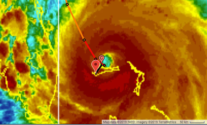
- Not much to say... Dorian is still pummeling Grand Bahama. It has barely moved since last night. Keep in mind that normally hurricanes travel forward at about 10-15mph. So the poor people on the island have been enduring hurricane conditions for almost 24 hours, which is unprecedented. And of course worrying as well is the storm surge. The highest point on the island is only 40 feet... In Abaco the situation is dire as well, where Dorian hit with 185mph winds. The Washington Post reported 5 fatalities, but didn't specify the island. Hopefully there will be no more fatalities.
     Freeport's distance to center Dorian by Advisory time (EDT):
          Sun  5PM 87 miles
          Sun 11PM 50 miles
          Mon  5AM 31 miles
          Mon 11AM 30 miles
          Mon  5PM 25 miles
          Mon 11PM 27 miles
          Tue  5AM 30 miles
          Tue 11AM 38 miles
          Tue  5PM 79 miles (yay!)
|
| Closest Point of Approach Relative to Freeport (Sep.2 5:50PM) |
Sunday, September 1, 2019 21:02PM EDT
- Agonizingly slow, devastating, unpredictable Dorian +
-
Good evening,
First the top story Dorian.
The NHC finally upgraded Dorian to Cat 5 status as of 8 am this morning despite findings last night late that it had reached this status already. Without a lengthy discussion, 2 out of 3 of their criteria did not match, hence the no call. As I shared previously, the upgrade at that time would not have meant much difference. However, overnight and through today, Dorian has rocketed from 150mph to 185 with 200 mph gusts. This is one very evil storm. RI did occur as was discussed earlier as well as the achievement of Cat 5 status. What wasn't expected was a rocket to 185 mph. I believe, after this is over, 190mph will be the final analysis. The difference of 5 mph will set a record but be of little consolation to those devastated.
Currently, the Northwestern Bahamas are experiencing tragic, catastrophic damage which will continue long term due to a 5 mph forward motion. Already having trashed Marsh Harbour and Elbow Cay, Freeport is the next largest populated area to be in Dorians path. While a beautiful area, most of the population of 25,000-30,000 are poor and their living quarters will be severely tested being bashed for hours as will the rest of Grand Bahama. Abaco is experiencing the eye now and will for a few more hours. Irma did the same thing here in the VI in Sept. 2017 and I experienced that 180 mph pounding for hours. Not something I want to go through again. I sympathize immensely. Prayers all Bahamians and stuck visitors survive. We can replace materials. We cannot replace life.
I stand by my reflection on my previous post re: Florida. Has not turned yet. You are not out of serious danger. Evacuate if mandatorily told too. Your life and maybe your families will depend on it especially due to the unknowns ahead. The closer it gets to Florida, the damage impacts will be greatly enhanced and will have far reaching effects inland. The turn closer to the coast will rake the entire east coast of Florida aka Matthew but worse, damage Georgia which is semi protected by its "innie" status along the coast, possibly make a direct hit close to Charleston, SC and ravage the rest of SC to the OBX from then on. Until it turns, when it turns, is anyone's guess as it was supposed to start turning about 10:30 am this morning. The weakness in the ridge did not arrive for it's date. It is now still moving just south of west at 270 degrees. Freeport is only about 70 miles from West Palm Beach. Hurricane force winds stretch out 45 miles from the center and TS force winds stretch out 140 miles so a good raking is in the making. The higher climb in latitude, the wider the wind field usually. Lots of impacts are expected far inland for some states. The most serious part still remains though, a direct hit cannot be ruled out for Florida.Â
Ok back to Caribbean observations and GOM.Â
91L in the south central Gulf of Mexico has some possibilities but doesn't appear to become Fernand, the next name on the hit list. We have another area of non designated interest a few hundred miles SSE of Bermuda but also is a blip at the moment with little chance of a Fernand name gain. About 120 miles SSW of the Cabo Verde islands is a disturbance which has the best potential of reaching the next name Fernand. At this time, a heavy rain maker for the southern Cabo Verde Islands according to the 8 pm discussion, the possibilities of it reaching TD status in 5 days is very good. Should be 92L soon and also forecast to be a fish storm. The one behind it will be very interesting I believe at this moment.
Use common sense people. Prepare if you haven't taken it seriously. Dorian has not been a good student of the weather technology we have as tools. It has exceeded expectations like an AP student with a normal C average. Have a plan A and a Plan B. Check on your neighbors who aren't as healthy, ambulatory, or are otherwise impaired. Pets should not be disregarded either. They are a part of our family. Take care of them.
More tomorrow. Good luck to all tonight and in the coming days. Prayers for those in the path.Â
Dave
Sunday, September 1, 2019 11:03AM PDT - Catastrophic Hurricane Dorian
- I hate writing these updates... Dorian just made landfall in Great Abaco Island as a Category 5 storm, packing 185 mph winds... For comparison Irma and Maria were packing 180 and 175 mph winds at their peak. Further worsening the situation is that Dorian is moving slow and expected to further slow down. Normally hurricanes travel at around 10-15 mph, Dorian's forward speed will only be about 3 mph over the next 2 days! You can only imagine what the continued battering of the winds will do to buildings, plus continued rainfall and more importantly the buildup of the storm surge. Quoting the latest advisory: "A life-threatening storm surge will raise water levels by as much as 18 to 23 feet above normal tide levels in areas of onshore winds on the Abaco Islands and Grand Bahama Island. Near the coast, the surge will be accompanied by large and destructive waves."
Below I made a table to show the progress of the storm over the Bahamas in numbers. I list the closest point of approach of the eye with Marsh Harbour (Abaco) and Freeport (Grand Bahama) over time, the distance the storm has traveled between the positions (d) and the forward speed. Right now the forward speed is 7mph, but will slow down to 3mph. Monday morning the storm will be closest to Freeport, but as you can see below 12 hours after the storm is closest it is still very close. Important note Although I give numbers relative to the eye, the hurricane is not a point. Don't focus on the eye alone or assume the forecasted track is right. Hurricanes tend to 'wobble' a bit, eye replacements occur as well. This is not an exact science.
                                      CPA
                                     MH  FP   d speed
      NOW  Sun  2PM  185 MPH  CAT-5   4  99     7 mph
      12H  Sun  8PM  175 MPH  CAT-5  34  62  38 6 mph
      24H  Mon  8AM  165 MPH  CAT-5  85  21  51 4 mph
      36H  Mon  8PM  155 MPH  CAT-4 119  36  34 3 mph
      48H  Tue  8AM  140 MPH  CAT-4 151  73  37 3 mph
      72H  Wed  8AM  115 MPH  CAT-3 286 235 166 7 mph
-Gert
|
Dorian September 1, 2019 14:10EDT
View the latest storm centered image and loop |
Saturday, August 31, 2019 23:06PM EDT
- Update
-
Good night,

Seems the NHC is being very conservative at this moment in calling
Dorian a Cat 5 even though numerous instruments from NOAA and HH
aircraft appear otherwise. Thatâs really not important. The
difference as I noted before is really negligible. 150 mph or 160 mph
is still going to rock your world. Whatâs important is nothings
changed for now substantially from an hour ago.

Be safe and ready.

Dave

Sent from my iPhone
Saturday, August 31, 2019 22:17PM EDT
- Just plain BAD and non conforming Dorian
-
Good evening all,
First things first as we are the Caribbean Hurricane Network. We have a wave just splashed off the African coast which has potential evil intentions to the Caribbean about 8-10 days from now. There is also the next two waves of the same caliber behind it. Please watch and get ready for a potential September rodeo. In the GOM, we have a low off the west coast of Cuba which could be a TS in a few days. The western coastal areas of the GOM should be wary of this potential development.Â
The NW Bahamas and Dorian. The Nassau radar is just now showing the appearance of high end Cat 4, will be Cat 5, Dorian's eye as it approaches Grand Abaco, Little Abaco Island, pop 17,000, Marsh Harbour and the rest of Grand Bahama Island including Freeport. This is about 175 ENE of Nassau. The new radar installed at Marsh Harbour probably won't survive this event sadly. HH data shows several readings now above Cat 5 strength and these are confirmed. It should be designated Cat 5 Dorian, with 160 mph winds as of 11pm advisory tonight which Gert and I have shared previously it ultimately would be. This is catastrophic. Right now, it looks like an EWRC (Eye Wall Replacement Cycle) is about to start which will keep it's intensity a bit lower later but enlarge the wind field. Once out of that cycle, the monster will ramble on. But where will it ramble?
Well now hasn't that been the million dollar or in this case billions of dollars question the last 3 days? That turn to the north before Freeport? That weakness in the ridge allowing it to turn north pretty sharply before? I'm not a fan of this scenario. I believe it will not turn as fast as is forecast now and will move further west as of the 11pm advisory. If it doesn't turn before Freeport, then Florida, trouble will be at your less than 100 mile doorstep. Your complacency from yesterday should be re-replaced with real concern. Those preparations you made and thought were for naught just might be a saving grace.
Bottom line, Florida your in it no matter what. I shared before, Dorian has not behaved well so why would you believe it will now? I hope I am wrong about this as I hoped I was wrong about Irma. A direct hit from Dorian is still on the table and then a turn to the north affecting Georgia, SC and NC as a hurricane into the end of next week. Even wobbles will change the track dynamics.
I'm not going to speculate yet on the next few days until tomorrow is over. Too many variables but as a veteran of riding out every storm in the VI for the last 30 years except for Cat 1 Dorian, I can tell you this: Ignoring the potential of Dorian can be a deadly possibility among many states. A true formidable buzzsaw of a hurricane.Â
Keep vigilant, safe, and check on those who are elderly and neighbors who don't have the means. Preparation is key. Evacuate if you are told to. Don't be one of those.
Dave
Saturday, August 31, 2019 11:30AM EDT
- Dangerous Dorian
-
Good morning,
I will have a longer detailed update tonight but wanted to say our prayers are with the people of the NW Bahamas as Dorian takes her Cat 4 self for a very unwanted visit and quite possibly will be a Cat 5 as I alluded to previously a few days ago. There will not be much difference between a high end Cat 4 and a Cat 5 though. This will be a many hour event traversing the whole hurricane for these people and the dangers cannot be dismissed or ignored. Dorian is not going to go away. Fluctuations will happen and we can only hope an eye wall replacement cycle happens at the same time of impact lessening, but not by much, Dorians strength.
For those of you who think your safe now, think again. Yes, the "cone" has shifted as well as many of the models to the east but since when has Dorian paid attention to the models and forecast tracks since it formed? It really hasn't listened and Mother Nature makes her own rules. We try our best to interpret them. So, Florida, it's still possible to defy these forecast and hit the coast and then turn north. It's all about when it feels the weakness in the ridge and that will come when it wants, not when we want it to. Georgia, SC and NC you need to be prepared as well.Â
There are some in Florida who are upset at the government because they feel they were misled into spending alot of money preparing for possible disaster. I think that money was well spent. If the government wasn't proactive in trying to warn you about life threatening situations, and you were impacted, then you would be outraged and maybe even dead. Think about that.
So, no one is out of the woods yet and certainly the NW Bahamas probably won't have any woods left so please say a prayer for them as Dorian approaches. Then pray for the east coast.
Dave
Friday, August 30, 2019 15:37PM PDT - Bahamas
- Dorian has become much better organized and is now a Category 3 hurricane. It is currently about 400 miles from Abaco (Bahamas). The NHC forecasted track shifted a bit more to the north. Also, the ECMWF model is now in more agreement with the NHC one, and is not showing the dip to the south anymore (see my post from yesterday). So now it looks like that Dorian will cross Abaco as a Category 4 storm packing 140mph sustained winds within 2 days. The center might actually just skirt north of it, but that is basically irrelevant with a storm of this magnitude. The closest point of approach with Marsh Harbour, Abaco is only 20 miles in about 2 days (see image below). For Grand Bahama it is unfortunately basically the same story, it will be very close. For Nassau it looks a bit better (CPA 125 miles), unless the forecast takes it more south again...
After the Bahamas its next target is Florida. Right now the landfall seems to be near Fort Pierce, north of West Palm Beach. Models are not in strong agreement when Dorian will start turning north. It might even start before making landfall in Florida, which might make the storm surge a lot worse for people up north. The ECMWF model actually shows Dorian almost stalling above the Bahamas for almost a day before making a turn to the north.
So there are quite a lot of uncertainties of when and where. This has the potential of becoming a Category 5 storm when it crosses the warm Gulf Stream. Intensity has never been a strong suit of the numerical models, they do better in forecasting where it goes. People in the northern Bahamas really need to prepare for the landfall of a Category 4 (or more) storm, but also people more south need to keep close attention. Dorian has surprised us before with a little jog to the north. A little jog to the south now would make a huge difference depending on where you live, so you better be prepared regardless. -Gert
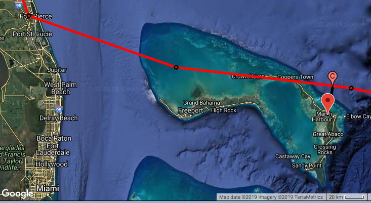
|
| 5PM Advisories showing track and CPA with Abaco, red = Category 4 [note the scale bar] |
Thursday, August 29, 2019 21:42PM PDT - ECMWF Model
- Not to diss the NHC forecast, but I just want to point to the model runs of the well respected ECMWF model. These show that Dorian will go a bit south of the official NHC forecast. For people in the Bahamas this can make a huge difference. Look at the tracks below, showing the forecast for the upcoming days. Or play with it yourself on the ECMWF website. It is still too bad that these model runs are not included in the spaghetti plots above in the tools section. See also Dave's discussion below. -Gert
~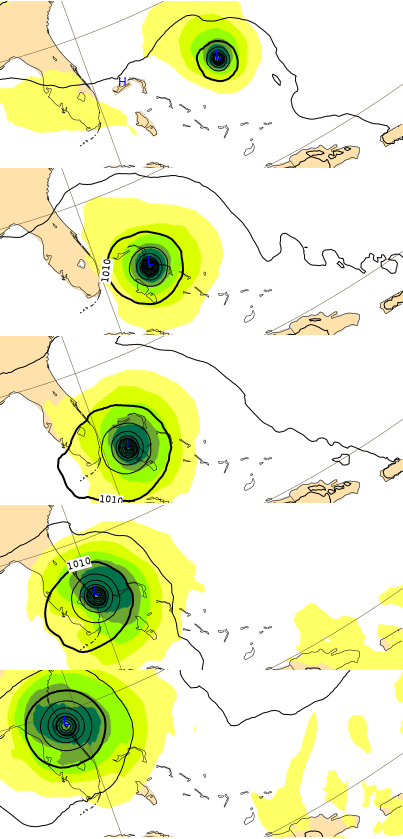
|
| - - - ECMWF Model Runs Saturday - Thursday - - - |
Thursday, August 29, 2019 18:55PM EDT
- Dorian the Destroyer
-
Good evening all,
Previous TS Dorian pulled a Houdini on most of us by reforming his center to the north of St. Lucia and heading straight on a NW trek for the USVI's and BVI's, sparing Puerto Rico and the DR, which was the original destination consensus of models and forecasters. Then, he has the audacity to further throw the models and forecasters into a tizzy by becoming a Cat 1 hurricane right on top of St. Thomas way earlier than expected. Now, the scorpion sting of his tail (seems like all these storms have a lashing tail), is dumping flooding rains on Puerto Rico which is receiving more rain now than yesterday when Dorian was morphing into a hurricane. A flood watch was up again for St. Thomas. St. John took a lashing yesterday as well while St. Croix, who was the brunt taker initially, took a somewhat lesser hit although any beating is a bad thing, especially only two years after Maria.
What else is out there? Off to the east we have a wave ready for splashdown which is a cause for concern but likely a fish storm as Dorian paved the way helping to moisturize the environment while the wave behind that I believe has evil intentions. Time will tell on these. There also is a possibility a low in the western Atlantic moves into the GOM and reaches TS status next week or sooner.
So, the Bahamas, as Gert shared earlier, will be the next, unwilling recipient of a growing, dangerous, life threatening, rapidly intensified Dorian, who, at Cat 3 or Cat 4 status, will be a destructive force on an island chain not much over sea level. The storm surge could be so great, small sand bars and cays could disappear while new ones are made! Projections are for Dorian to slow down which creates more destruction from wind and surge.
Right now, Dorians EWRC (Eye Wall Replacement Cycle) is just about done so the strengthening will begin shortly while it appears to be shedding it's tail, now that it has no use for it anymore. SST's are running 84-86 degrees, wind shear will be low, cirrus outflow has improved dramatically which is positive for rapid intensification and no land masses are ahead for friction disruption.
Ahead are many variables on track and intensity and we should know a lot more tomorrow morning. As a storm gains latitude it usually gains in size and the windfield increases. If Dorian slows down, it has a small chance of turning before Florida but unlikely. It most likely will turn north somewhere around the middle to west side of Florida or even enter the Gulf then north for a third landfall after coming ashore around West Palm Beach. This of course, is based on what we know now. On another note, I feel bad for all the sea turtle nests along the Florida coast which will be destroyed by Dorians pounding waves and storm surge. Sad.
What we don't know is: Where exactly will it strike the Bahamas and the east coast? Too early to tell. Can it reach Cat 5 status? Yes I think it has a decent shot. When will it turn north? Again, too early to tell. Is Miami in danger? Yes I wouldn't rule it out.
Prepare people. Be prepared to evacuate. Don't stay if asked to leave. You put your lives and those who you call for help later in jeopardy. Now is not the time for selfishness and just plain stupid. Common sense and prudence needs to be followed. More tomorrow. Be safe.
Dave
Thursday, August 29, 2019 08:42AM PDT - Bahamas next
- Wow, that little jog to the north (meaning a more eastward track for us) caught us a little by surprise. Although, by now we should expect the unexpected, and therefore should have over prepared. So... right now Dorian is still a Cat-1 hurricane, but on the latest satellite loop (see tools section above) it seems that an eye is starting to form. Indeed, Dorian is expected to strengthen into a major Category 3 hurricane within 24 hours, and might become a Category 4 (!) hurricane in 72 hours... The storm will cross the very warm waters of the Gulf Stream, acting as fuel for the hurricane, so we should not be surprised if the storm suddenly strengthens even more before making landfall in the US.
Right now the center of the storm is expected to move just to the north of the Bahamas. Its closest point of approach with Nassau is about 140 miles, but the CPA is only 35 miles for Marsh Harbour, Abaco and 50 miles for Freeport, Grand Bahama in about 3 days. At that time the official forecast predicts Dorian to be a Category 4 storm! Also, I have noticed that the 5-day forecasts have been trending south a bit, the well respected ECMWF model is also showing a track more south than the official NHC forecast, so that this into account. As always, don't focus just on the track! This is going to be a major storm, entering very warm waters!
For the US, right now it looks that Dorian will make landfall around Vero Beach and pass just south of Orlando. Not good at all. I have listed coordinates of many cities in Florida in the closest point of approach-tool. Although we are the 'Caribbean' Hurricane Network, I have noticed many people in other locations using the very popular CPA tool. So people in the Bahamas and Florida, keep very close eyes on this storm. Over prepare and expect the unexpected! -Gert
Wednesday, August 28, 2019 09:18AM EDT
- Dorian arrives in the VI
-
Good morning,
After rushing by Barbados with limited damage, making a direct hit on the island of St. Lucia with minimal damage, TS Dorian has made a beeline for the US and British Virgin Islands and Puerto Rico. Was this forecast to happen?
In the beginning it was a possibility but remote as the models were in good agreement it was going to visit the Mona Passage, eastern DR and western PR. However, the direct interaction and subsequent disruption with St. Lucia caused the center to reform miles north of St. Lucia as opposed to the west which was not forecast to occur. This unforeseen and unlikely scenario of center reformation to the north is one big reason Dorian is visiting the Virgin Islands and much of PR. The other reason is the weakness in the ridge developed earlier than expected hence the turn to the NW earlier. These two reasons are the main ones we have an un welcomed visitor today.
Dorian is down to 1002 mb with estimated 65 mph winds gusting to 80 is spots. Located approx. 45 miles SE of St. Croix moving 13 mph towards the NW, Dorian is expected to attain Cat 1 status shortly. There is not much difference between a strong TS and a low end Cat 1 hurricane so don't be misled.
Dorian is already dumping copious amounts of rain on St. Croix which will feel the stronger forces of Dorian than the BVI and St. Thomas/St. John. Evacuation shelters are open territory wide and the Governor has issued a curfew effective at noon today until 6 am tomorrow.. Flash flood watches are up as well as marine warnings. Waterspouts are possible and one was spotted yesterday off St. Thomas. Most buildings will be ok but still damaged ones from hurricanes Irma and Maria will certainly suffer as will those many who still have blue tarps as roofs. Flooding will occur as will landslides. Sandbags are being distributed at numerous places on St. Croix and the Dept of Public Works on STT and STJ up to 10 per household. WAPA, our favorite utility, will almost certainly go out but fortunately, we still have a good number of lineman on the islands who can help restore power quickly. I hope the improvements after Irmaria with respect to the lines, poles, depth and location of those poles holds up.
At this speed and track Dorian will have left the VI and PR by tomorrow afternoon. After some weakening due to land interaction and some time experiencing a bit of higher wind shear, Dorian should start on a strengthening regimen which will be bad news for someone down the road on the mainland. The Turks and Caicos and Bahamas will be first. Then its a tossup depending when Dorian turns more to the west. SST's will be very warm as in around 84 degrees, with some gulf stream heat added, low wind shear and a much moister environment which favors not only intensification but Rapid Intensification. Anywhere between Florida and South Carolina is a potential victim 5-6 days down the road as forecasts so far in advance are prone to as much as 200 miles of error.Â
What's not probable is Dorian taking a easterly turn and becoming a fish storm going out to sea. What is probable is a Cat 2 or 3 striking the east coast from Florida to South Carolina. Right now, I'm thinking Cat 3 if Florida and Bahamas.Â
Looking over our shoulder out to the east are two waves marching across the Atlantic. Having paved the way, Dorian is the vanguard of the busy season. I'm most concerned about the second of these waves but for now, all eyes and concern are on Dorian.
Finish preparations, hurricane plans and stay safe!!
DaveÂ
Tuesday, August 27, 2019 10:31AM PDT - Next for Dorian?
- Dorian passed St.Lucia, and the latest reports indicate that it was kind of a non-event. Great! The future of Dorian is still a bit uncertain. Now it looks like it won't become a hurricane but still remain a tropical storm while it passes through the 'hurricane graveyard'. For a neat analysis check out Brian McNoldy's excellent blog here. He has some great graphics of satellite loops and model forecast tracks. Stay tuned... -Gert
Monday, August 26, 2019 21:29PM EDT
- Dorian and friend
-
Good evening,
The friend, 98L, has morphed into TD#6 and is on a race for a date with the Canadian Maritimes on Friday as a minimal TS whose name will be Erin. Paralleling the US East Coast and no threat to direct US land interests, Erin will be a blip on the books of 2019 as a named storm.
On the other hand, here comes TS Dorian. Unsure of his week's intentions after his collision with Barbados as I write, St. Lucia appears to be in for a weak or strong TS basedÂon the hurricane hunters flight data who are in Dorian now sampling but finding a weaker storm at the moment. Regardless, the effects will essentially be the same: heavy squally rain, blustery gusty storm force winds, power outages and flooding. Barbados, at this moment, is getting direct effects as Dorian passes over on it's way to St. Lucia. We shall see some reports tomorrow on the aftermath.
After Barbados, St. Lucia appears to be in a direct line of fire from Dorian under a hurricane watch. Might be downgraded at 11 pm tonight depending again on recon data. Exiting St. Lucia and entering the Eastern Caribbean, Dorian may or not be a hurricane by the time it reaches the Mona Passage area between the DR and PR. This would put the harshest part of the storm, the NE quadrant, right over western PR. Not good for storm challenged PR.
Many variables are playing into the Dorian event and so much cannot be concluded at this time with intensity the biggest. The track is fairly conclusive among a consensus of the models and if Dorian survives the storm graveyard of the Atlantic named the Eastern Caribbean, the T&C, Bahamas, Florida andÂeventually the GOM could be an unwelcome Dorian host.Â
Note on intensity. Small storms can fluctuate quickly, up or down. Dry air in-gestation continues to be Dorian's kryptonite as the factors of favorability; low wind shear and warm oceanic content along withÂgood structure at the low and high levelsÂis very, very good.
Tomorrow morning, we shall see and review hurricane hunter and NOAA data and have a better take on Dorian. Dorian has Rapid Intensification possibilities down the roadÂif survival of a DR mountainous encounter is achieved.ÂA few miles either way can make a big difference by the weekend.
The VI is so far, not under the gun at this time although the US Coast Guard COPT has closed all St. Croix ports to all shipping traffic effective 8 pm tonight until safe to reopen. Rain squalls and gusty winds will be our norm for a short bit.
Dave
Monday, August 26, 2019 09:45AM PDT - Still a tropical storm
- Not much has changed since yesterday. Dorian is still 'just' a tropical storm with 60mph winds, and has some problems getting more organized. The center is about 135 miles from Barbados. The outer bands are nearing Barbados, and the center of the storm will move very close to the island. Then, still as a tropical storm, the center of Dorian will move just south of St.Lucia. Many warnings and watches have been posted for the islands, see the latest advisories.
What happens next to Dorian is still a big question mark. Some models suggest that Dorian will strengthen into a hurricane while others indicate that it might dissipate in the Caribbean Sea... The track of this system is a bit more east again compared to yesterday. So Puerto Rico, you are not out of the woods yet. Right now the closest point of approach for Ponce, Puerto Rico is only 45 miles. The official forecast puts Dorian at a category 1 hurricane, packing 80mph winds... Stay tuned, in the meantime use the above tools to assess the situation for your location. -Gert
Sunday, August 25, 2019 11:57AM PDT - Dorian going more south (and west)
- The latest advisories show that Dorian is going more south than earlier forecasted. It is now expected to pass Tuesday just south of Barbados, instead of north. Also, it is expected to now pass in between St.Lucia and St.Vincent. It should still be 'just' a tropical storm by then. Indeed, tropical storm warnings and watches have been posted for these islands. As reported earlier wind-wise this is a relatively small storm, however, that doesn't mean we don't have to worry about this storm. The rain and swell will be the biggest factor. Just look at the image below of the scale of the storm relative to the closest point of approach with Barbados.
After it passes the island chain it looks like it is going to bypass Puerto Rico, and instead is aiming for Hispaniola. The intensity forecast is a bit uncertain, and although Dorian is expected to become a Category-1 hurricane, by the time it reaches the Dominican Republic it is forecasted to have weakened to a tropical storm again. Hope the storm will not veer more west and go over Haiti. They unfortunately don't cope well with wet storms...
Use the tools above to check out the threat of the storm to you, and stay tuned... -Gert
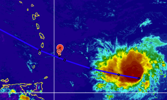
|
| - - - Dorian relative to Barbados [line=track, blue=tropical storm strength) - - - |
Saturday, August 24, 2019 22:56PM EDT
- Dorian and others
-
Good afternoon,
Thank you Gert for stepping in. I had written this earlier but it failed to send from upstate NY so I am modifying it for the present conditions.
I leave the islands for a week for my well Dave checkup during a relative period of calm knowing that the Atlantic was tipping the hourglass over to initiate tropical activity for and what happens? Hour glass overheat with the formations Chantal, 90L, 98L and now TS Dorian.Â
Chantal. Now deceased. A short lived, far north forming fish storm with a name headed towards Europe menacing shipping along the way. And the fish.
90L. Threatening the Gulf Coast along Texas and Louisiana, 90L was flaring up with TD possibilities but they are no longer as it has moved inland unless it moves back over open water. This will be a prolific rainmaker and flooding event as where this rain falls will be over areas saturated previous to, and exacerbated by, Hurricane Barry.
98L. Looking ominous off the coast of Florida, 98L looks to become a named storm while staying off the east coast on it's trek north and east. The Bahamas and the southern east coast look to pick up copious rainfall amounts but it is unlikely to make a US landfall while the Canadian Maritimes are landfalling possibility.Â
TS Dorian:Â Surviving a hostile trip, this CV seedling is now become Dorian hours earlier than expected. A small compact storm such as Dorian can fluctuate in intensity up or down quickly and change it's track quickly as well. So, right now the models are in pretty decent agreement on the track which brings it just south of St. Lucia as a strong TS but most likely as a Cat 1 hurricane. The models will have something concrete to work on and each successive run should be more accurate as to intensity and track. The early track shows it eventually interacting with the mountainous Greater Antilles which would tear a small system apart but if subsequent tracks are adjusted northward, then PR and the VI will have a very uninvited Cat 1 guest, maybe Cat 2, only two years after twin Cat 5 sisters Irma and Maria made their unforgettable, catastrophicly destructive visit. Due to the warmer waters and lowering wind shear, and if it seals off the dry air ahead, the potential for rapid intensification is in the playing deck as well. Down the road, if it survives the mountainous interaction, or avoids it somehow, the east coast, Florida, Bahamas, and T&C could be in for a major ride.
It's early yet as I shared. Please get prepared if you haven't already. This is the key.
I'll have more tomorrow morning.
Dave
Saturday, August 24, 2019 11:38AM PDT - Number Five
- The tropical wave I mentioned earlier in the week was able to get more organized, and has now been upgraded to Tropical Depression Five, the first Cape Verde of the season. It is expected to become a tropical storm (named Dorian) in about 24 hours. It might even strengthen into a Category 1 hurricane in 4 days or so, but that's still pretty far away in the forecast.
The good news is that it is a pretty small storm, so the high winds will be constrained to a relatively small area. The storm is also pretty far south, at only 10.4N. It is moving westward now, but expected to curve a bit to the north before it reaches the islands.
Right now looking at the closest point of approach, the storm will pass Barbados at only about 40 miles to the north on Tuesday, still as a tropical storm, and is expected to cross the island chain between St.Lucia and Martinique, also on Tuesday. Further down the road, it looks like it will pass just south of Puerto Rico, but that is still pretty uncertain, and depends on how much of a turn to the north it will make. So stay tuned and in the meantime check to tools above to get more info on this storm.
-Gert
Tuesday, August 20, 2019 19:38PM PDT - Chantal
- After a dry spell of over a month (Hurricane Barry made landfall in Louisiana on July 13) we have our third tropical storm, Chantal. It is pretty far north (40.2N). Bermuda by comparison is at 32N. In fact Chantal is currently already about 700 miles to the north-east of Bermuda and moving away. The storm is not expected to strengthen much either and is no threat to the islands or any other land. A fish storm as we like to call them.
Also not much else going on in the Atlantic. I see a tropical wave coming off the African coast but there seems to be a lot of wind shear, so that probably won't develop into something for awhile. Traditionally we have like a 2 peaked hurricane season for the eastern Caribbean, one about now and one early-mid September (see this page, which I really have to update someday...). So don't call this a slow season yet! -Gert
Saturday, August 3, 2019 20:07PM EDT
- The fizzling 96L
-
Good Saturday evening,
The imposter, 96L, is still lurking off to the east of the Eastern Caribbean Islands but the earlier menacing gestures of an early season named system generated from the Cabo Verde Islands area have diminished significantly in the last few days. The upper level shearing low, aka TUTT, located just north of the NE Caribbean Islands, with a dash of Saharan Dust drying out the atmosphere, has contributed to the gradual reduction of percentages of development from the NHC. The models concur. But.....
Large, elongated and discombobulated, 96L still does have a small chance of at least reaching TD status, according to about 50% of the model ensembles, if it can get it's act together but the window is closing rapidly. If it does reach that status, it will be short lived. Still, Tuesday into Thursday widespread showers, thunderstorms, rough seas and gusty winds will be the menu much like 95L before it.
Meanwhile, the wave train continues behind 96L so a wetter pattern will continue the next few weeks with cyclogenesis conditions not expected to manifest themselves until the last week of August. Will it be a quiet season this year or will the season suddenly explode with activity and possible calamity? It will be interesting and problematic at the same time. Interesting to see how it all pans out. Problematic if just one storm is the calamity. After all, it does, only take one.
Be safe. Be prepared.Â
Have a good weekend everyone!
Dave
Friday, August 2, 2019 14:29PM PDT - 96L
- Dave forecasted the initiation of Invest 96L last Tuesday. Things are looking a bit better now. That is, less threatening. It is still a few days away, and it could still become Tropical Storm Chantal before it reaches the islands in 3-4 days or so, but it is not likely to reach hurricane strength in the near future. Below a snippet from the Tropical Weather Discussion regarding 96L:
Looking ahead, this wave will
continue to generate limited showers and thunderstorms. Some
slow development is possible, and a tropical depression could
form well east of the Leeward Islands by early next week. Upper-
level winds are forecast to become less conducive for development
as the system approaches the Leeward Islands Tuesday into Wed.
Check also the track forecast from ral.ucar.edu and accompanying intensity guidance above for the latest developments. Regardless what I say here, we still need to track this one, because you never know... -Gert
Tuesday, July 30, 2019 21:08PM EDT
- 96L soon
-
Good evening all,
It has been a while and I hope you are well, and ready.
While the tropical Pacific is getting all the attention at the moment, which is usually the case at this time of the year, the tropical Atlantic and GOM is starting to wake up from it's spring slumber, post Hurricane Barry. Hurricanes Erick and Flossie will menace Hawaii with Erick the more formidable of the two and the vanguard of both with most models forecasting him to stay to the south and basically bashing the southern coasts with high surf and erosion. Flossie, hundreds of miles behind on his coattails, is expected to weaken upon approach as most do from this direction but also forecast to become the closer encounter of the two systems. I expect Flossie to surprise: either a dramatic re-curve close to Hawaii or, at a minimum, a good TS lashing directly. Time will tell. Now to our arena of the tropics where time will tell as well on our two waves of interest with a non performer in the middle.Â
95L. Quite the nuisance especially in eastern Puerto Rico with flooding, is broad in scope with no closed circulation at any level and about to tangle with the Dominican Republics mountainous eastern flank. While dropping some needed rainfall on the Virgin Islands, it has soaked east and southern parts of Puerto Rico with almost 8 inches of precipitation and there is more on the way. Once it makes it's way to the Florida Straits and southern Bahamas, it will have a narrow window for development before being carried off by an approaching front. In the meantime, rains and squalls will affect the DR, Turks and Caicos, Bahamas and make Florida's weekend from Friday through Monday wet and rough, especially on the east coast with high surf and rip currents. Hopefully, the turtle nests which have been laid already are far enough out of the surfs range as this is looking to be a record breaking turtle nesting season from Florida to NC.Â
The non performer in the middle. Almost hidden behind 95L, this one will just contribute to the current shower and thunderstorm activity while enhancing the flooding potential in Puerto Rico along with some rough seas and surf.Â
96L. An early, for season, potential Cabo Verde storm looking to make a name for itself, 96L will be lurking for the next few days fighting the SAL to the north and relatively cool, under 80 degrees F waters ahead of it while chugging ahead at a steady 15 mph clip. By Friday to Saturday, the dry air intrusion will lessen (less dust), wind shear will be more friendly, and sea surface temperatures, aka SST's, will be above the heat engine's 80 degree threshold which is considered the minimum for cyclogenesis although it has happened below that metric a few times in the past.Â
It's too early at the moment to obviously make concrete predictions on where, how big, what and will occur. However, this might turn in to a wake up call for the Eastern Caribbean if conditions pull themselves together in a few days. A TD, TS or another surprise is not off the table so just get prepared if you haven't as season is heating up for real. Preparation is the key to it all. I'll have more as the week moves on. Be safe!
Dave
Monday, July 22, 2019 14:51PM PDT - Tropical Depression Three
- Tropical depression #3 formed near the Bahamas. It is moving northwestward, and since it is also not expected to strengthen much (it might not even reach tropical storm 'named' status), it is not a threat. You can use the tools above to evaluate the possible threat to you. -Gert
Wednesday, July 10, 2019 09:25AM EDT
- 92L and a bit more
-
Good morning,
Things have been quiet since the beginning of June as they usually are but 92L has jump started July with dreaded anticipation along the Gulf Coast. Hurricane Hunters are scheduled to investigate 92L later this afternoon and might find a surprise or two. Unusual but not unprecedented for it's formative trek through the Midwest diving southeast towards the GOM, 92L is now poised to become the next named storm in the young season, Barry.
Regardless of whether it reaches named status, which it probably will, the real threat at this moment is more flooding along the Mississippi River. While forecast to crest just 1 foot above the levees in New Orleans, areas to the west of New Orleans could actually use some good rain due to moderate drought. Problem is, if this plays out, there will be much more rain than bargained for.
Until a COC is formed, forecasting the track and intensity will be difficult. If it stays close to the coast, it's intensity will be stalled due to land interaction even though most land along the coast is pretty flat which limits friction. The farther south then west it moves, then it's over extremely warm water, like 86-90 degrees, which is prime fuel for intensification. Normally thisÂcan leadÂto RI (Rapid Intensification) but wind shear should limit that possibility.
Landfall is now forecast to occur in western LA/TX border. While population levels are far less, the eastern and northern sides will would receive the bulk of the rain and wind where the more populous areas reside. It is not out of the realm of possibility, at the moment, that Houston could be in the crosshairs as well as a Cat 1 hurricane.
Preparations should be well underway regardless as it will land with heavy rains, flooding and possibly strong winds. In the Atlantic, it's quiet with copious amounts of Sahara Dust doing it's normal, seasonal protective duty suppressing formation and rain activity as a whole. We in the NE Caribbean could use some regular rain as it's been droughty since December.
Dave
Monday, July 8, 2019 16:14PM PDT - Sargassum...
- For some islands it has become a big (smelly) nuisance... Sargassum on beautiful beaches. Recently Wang et al published an article on it in Science, calling it the biggest bloom. Since 2011 Sargassum has become much more prevalent in the Atlantic Ocean and Caribbean Sea. In the last couple of years it has been so bad that you can see on satellite images a large belt of Sargassum extending from West Africa and northern South America to the Caribbean Sea.
The authors think that the increase has to do with higher nutrient (nitrate and/or phosphate, similar to what is in fertilizer) input to the ocean. They see correlations with increased upwelling off West Africa (bringing nutrient rich deep ocean water to the surface) and increased nutrient load of the Amazon River, due to deforestation and increased fertilizer use in Brazil.. Also, if a lot of Sargassum survives the previous winter, it will also make it a bad Sargassum year. Unfortunately they don't think it is going to get much better in the future. They also propose a method to predict how bad "the Sargassum season" (it peaks in July) is going to be a few months ahead. Read the full article here, it is pretty easy to follow, not too "sciency".
In hurricane news... There is an area of disturbed weather in the southeastern US (Georgia/Alabama) that is moving south. It might become something one it enters the Gulf of Mexico. The Caribbean islands are not threatened. -Gert
 |
| - - - Sargassum distribution July 2018 - - - |
Saturday, June 1, 2019 09:08AM EDT
- New season starts with #2
-
Good morning,
And, so it begins. The official start of the 2019 Atlantic Hurricane Season. While today is considered the official start, we have already had our first named storm, sub tropical storm Andrea which was close to Bermuda on May 20th.ÂPicked up by a cold front, Andrea was only a threat to shipping and fishing, and rode off into history soon after.
Right on cue, June 1st, we now have a second opportunity for a named storm which for now is labeled Invest 91L. This system is now located over the Yucatan Peninsula of Mexico and is expected to shortly enter the very warm Bay of Campeche where the NHC gives it, as of now, a 50% chance of development. The next storm name would be Barry but a short lived one at that if 91L intensifies into a TS. With only a few days to form, it likely will just make TD status but stranger things have happened, especially over the last few years.
Major effectsÂfor Mexico will be blustery winds, torrential rain, flooding and mudslides. There will also be potentially heavy rainÂaffecting Texas and the flood ravaged central Midwest with Oklahoma, Missouri, etc. as this moistureÂis drawn up from Mexico next week, further exacerbating an already devastating situation.
Looking elsewhere it appears pretty tranquil with heavy rains affecting areas of the NE Caribbean which are in severe drought. The MDR (Main Development Region) is quiet with a fewÂlow latitude tropical waves meandering across the Atlantic. This area already is showing warmer SST's whish is fuel for tropical storms but increased wind shear, courtesy of El Nino, is expected to counteract this rise. However, we have seen recently several storms survive and intensify in the face of moderate wind shear. So that by itself is not necessarily comforting. Saharan Dust levels are moderate as well which has been one of our protectors, especially into August.
This seasonÂhas many different predictions and it hard to read with the prime suspect, El Nino,Âlawyering up, not giving any answers as to whether it will continue a strong presence
inhibiting storm formation all through the season or will it fade in August/September, thus ushering in an open door policy for storm formation with major implications.
As usual, time will tell but that time moves fast so please start thinking about updating your hurricane evacuation plans and supplies. For those of us who went through Irma and Maria, you know not to downplay the possibilities.
DaveÂ
The list of names for 2019 is as follows:

Name           Pronunciation    Name            Pronunciation
-------------------------------------------------------------
Andrea         AN-dree-uh       Lorenzo         loh-REN-zoh
Barry          BAIR-ree         Melissa         meh-LIH-suh
Chantal        shahn-TAHL       Nestor          NES-tor
Dorian         DOR-ee-an        Olga            OAL-guh
Erin           AIR-rin          Pablo           PAHB-lo
Fernand        fair-NAHN        Rebekah         reh-BEH-kuh
Gabrielle      ga-bree-ELL      Sebastien       suh-BASH-chuhn
Humberto       oom-BAIR-toh     Tanya           TAHN-yuh
Imelda         ee-MEHL-dah      Van             van
Jerry          JEHR-ee          Wendy           WEN-dee
Karen          KAIR-ren
Wednesday, May 29, 2019 09:16AM PDT - NOAA predicts near normal hurricane season
- Not that it really means much, since one hurricane can spoil your whole season, it is still interesting to look at the different long-term forecasts. NOAA just came out with their's and they predict that there is a 40% chance of a near-normal season, 30% chance of above-normal and 30% below normal... They expect 9-15 named storms (12 is average), 4-8 hurricanes (6 is average), of which 2-4 could become major hurricanes (3 is average), the ones we fear most.
They do note that even though an El Nino is going on which normally suppresses hurricane activity, the above normal sea surface temperatures in the tropical Atlantic and Caribbean plus an enhanced west African monsoon kind of cancels out the 'negative' impact of the El Nino.
With the better satellites up in space hurricane forecast models should become better. NOAA's GFS weather model has gotten a major upgrade as well. Models have been getting very good at predicting the path of the storm. Intensity is another story. We have seen many times in the last couple of years that seemingly tame hurricanes all of a sudden became Cat-5 monsters. Last but not least, NOAA's National Hurricane Center and weather office in San Juan will this year also issue coastal storm surge watches for Puerto Rico and the US Virgin Islands. I am actually surprised that they hadn't so far...
So, only a few days left for the official start, we already had one storm, now is a good time to start your preparations.... You know what to do, you have been through it before! Just don't wait for the last moment. -Gert
Monday, May 20, 2019 19:42PM PDT - Andrea
- Guess I was just in time with updating my website, or maybe I jinxed it? In any case, we have our first (sub) tropical storm on our hands, Maria. It is currently about 300 miles southwest of Bermuda, and expected to move south of it (see the Closest Point of Approach-tool). It actually might not get close to the Rock at all, since Andrea is expected to dissipate in about 2 days and merge with a cold front. Storms like this we like! One (almost) down! -Gert
Sunday, May 19, 2019 15:46PM PDT - 2019 Season
- An annual ritual, making my website ready for the new season... New names are posted above. The names repeat every six years, so this is the same list as 2013. Sometimes names of 'big ones' get retired. The only new name on this list is Imelda, which replaced Ingrid. Ingrid was retired becaue it created a lot of damage in Mexico, which with hurricane Manuel attacking from the Pacific side, struck Mexico within a 24 hour period. Manuel was retired as well.
This is my 24th year of doing this! I started in 1996, 2 years before Google started, and when 'blogging' was not even a word. Maybe for its 25th anniversary I will change the look of this website and give it more 'modern' feel :-). Making the website ready for a new year involves moving a lot of files around, updating some scripts that download/process images, advisories, and making sure that my special tools will keep working. Hopefully I didn't break anything :-). In any case, welcome again to a new season. Hope that it will be a boring one! Also, don't forget that in order for me to keep the website running I am dependent on donations from you... -Gert
Tuesday, May 14, 2019 18:23PM EDT
- New Season
-
Good afternoon!
After a "winter" and a spring, the new 2019 hurricane season is at our doorstep officially in 18 days. This June 1, 2019. I hope everyone has at least thought of it's impending approach and also had those storm preparation plans somewhere in their thoughts as well.
Currently all is calm on the Eastern front with a few waves starting their migration off the coast of Africa but as is customary at this time of year, far south along the monsoon trough close to the inter tropical convergence zone. This, along with early season cool surface water temperatures aka SST's, wind shear and that always present Saharan Dust Layer aka SAL, usually mean none will develop or get close to developing this early. So far so good.
Here in the Virgin Islands, a drought has ensued. The island is dry, brown, getting bereft of foliage and brings back visions of everything stripped after a hurricane. Water trucks are running rampant, farmers are suffering immense troubles with crops and livestock, with no respite in short sight. Hopefully, in a few weeks, the drought should break but Âhopefully not all at once. A deluge will be harmful as well with flooding, runoff, and erosion.
Yes it's that time again. Preparation time, emergency kit time, evacuation if necessary planning time, check your generator time, hey you know the drill!
Plan for the worst. Hope for the best. We have been there done that Caribbean. Let's do it again!
Dave
Friday, May 3, 2019 13:55PM PDT - Cyclone Fani in India
- Fani made landfall in India just below Category 5 strength. One hundred million people are apparently in its path and more than a million have been evacuated. Hopefully it won't be as bad as in 1999 when more than 10,000 people died. The path takes it also close to Bangladesh. A lot of people live in river delta areas which are just above sea level, so even a minor storm surge could give a lot of problems... Read more on Google News. -Gert
Friday, April 5, 2019 09:51AM PDT - Normal season ahead?
- It is that time of the year again that Klotzbach et al., researchers at Colorado State issue their forecast of Atlantic Hurricane activity. They expect this season to be slightly below normal, with 13 named storms (12.1 is normal), 5 hurricanes (6.4 is normal) of which 2 become major (Category 3 or higher, 2.7 is normal). The probability for at least one major hurricane tracking through the Caribbean (a large area) is 39% (42% is normal).
The big question mark is as usually if El Nino conditions occur this Summer, which suppresses hurricane formation and strengthening. Right now we are in an El Nino, and although models are all over the place, most predict that the El Nino will still be there later this year. Good for us! Also, sea surface temperatures in the tropical Atlantic are a bit below normal, which is good as well.
They also issued an Excel spreadsheet with landfall probabilities for the Caribbean and Central America region. Below is the top 7 of the chance that at least one tropical storm (TS), hurricane (H) or major hurricane (MH) will track within 50 miles. I sorted the list by hurricane.
  Region               TS     H    MH
  Bahamas, The         68%   41%   22%
  Cuba                 66%   40%   20%
  Mexico               74%   40%   14%
  Dominican Republic   40%   24%    8%
  Haiti                35%   19%    9%
  Antigua and Barbuda  32%   19%    7%
  Cayman Islands       32%   19%    7%
As always, take these forecasts not too serious. They are not set in stone for sure, esp. the April forecast has modest skill. Nevertheless, it is nice to hear that it will probably be an about normal season, better than a forecast that predicts a highly active season. In any case, keep in mind that just one hurricane in your backyard will spoil your whole season! We still have to prepare as best as we can. A good time to start checking your hurricane shutters, possible flying/falling hazards around your house, emergency supplies, etc., is now. -Gert
Maintained & moderated by: Gert van Dijken (gert@gobeach.com).
Weather discussions also by Dave McDermott, St.Thomas, USVI.