|
|
|
- Chilly weather
|
- By Lisette Stevens <jaco.lass at gmail.com>
- Date: Wed, 11 Mar 2020 07:49:41 -0400
|
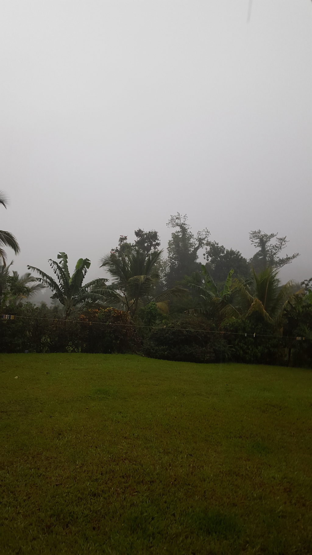
We need our Caribbean sunshine and warmth! Here in the valley it has been consistently chilly in the mornings and evenings, we have had quite a lot of rain as well.
The worrisome thing is that hurricane season will soon be upon us. We also are going to have to contend with the corona virus in the Caribbean! Unfortunately this is just a matter of time for all the islands. As we know it is already on some Caribbean islands. It is inevitable as we are having cruise ships visiting the islands and basically it will be here too. It is truly scary in my humble opinion.
How very depressing, the world wide economy will be affected. It is a catastrophe and extremely worrying especially on the islands. I do not think the weather is going to be such an issue for the time being.
I think any hurricane this year should be named HURRICANE CORONA????
What do the other correspondents feel? |
|
- RIP Miss Mermaid
|
- By Lisette Stevens <jaco.lass at gmail.com>
- Date: Wed, 12 Feb 2020 07:36:10 -0400
|
It is with a very heavy heart that we read the post this morning that Miss Mermaid has left this mortal earth. What an amzing woman. We were introduced to Miss Mermaid when we first started writing for stormcarib for Dominica in March 2007.
What a sense of humour! Her stories of everyday life in Tortolla had us creased up. Her sense of adventure and love of the Caribbean was awesome.
Dear Miss Mermaid may you rest in peace and keep everyone smiling in heaven. |
|
- Christmas Weather...
|
- By "dtkcomp2002 at yahoo.com" <dtkcomp2002 at yahoo.com>
- Date: Wed, 25 Dec 2019 00:06:00 +0000 (UTC)
|
The last few Days have blessed us with absolutely Gorgeous weather here in the Nature Isle of the Caribbean, Dominica. Of course, this has been a welcomed relief from the almost non-stop rainy weather which affected us from the day of General elections. It was quite a symbolic omen given the nature of the election campaign which occured, that left much to be desired from Government and elected officials in particular... Today, on Christmas eve the lovely extended sunny weather continued though we may get a stray shower or two as was the case last night. Of course, our last couple of Sundays too; the day from which Dominica gets its name in Latin & (the day of the Lord: Rev 1:10) were definitely gloriously bright in an almost unprecedented fashion.
On the other hand, apparently some of the other sister windward islands were not as fortunate particularly over the last couple of weeks according to their airport observations... Hopefully no serious active weather will be on the cards for the windwards as we head from Christmas into New Year's.
However, of even greater concern to us locally weather aside- is the major socio-political fall-out since the last General elections. With ongoing Political tensions in the Land albeit much subsisded all patriotic Dominicans are hoping & praying for the very best. |
|
- More Tropical activity still...
|
- By Micheal Colaire <nichs2002 at yahoo.com>
- Date: Tue, 19 Nov 2019 16:24:30 +0000 (UTC)
|
|
November is definitely Not All Over... And As was anticipated & predicted Tropical storm Sebastien has formed.Fortunately its not a strong storm and is expected to keep moving north of the islands. However, its proximity is influencing atmospheric stability over and near the islands. Some adverse weather is possible into the weekend. Keep safe and Vigilant everyone.
|
|
- Intensification...
|
- By Micheal Colaire <nichs2002 at yahoo.com>
- Date: Tue, 19 Nov 2019 05:22:26 +0000 (UTC)
|
|
The disturbance (90L) located just east of the Lesser Antilles seems to be increasingly deepening & consolidating its circulation and has more than surpassed that critical percentage number of 30% for the two day (48hrs) formation probability & has now infact attained 70%. Cyclogenesis is likely very much imminent and we could soon have Sebastien.
A depression or subtropical depression at the very least is highly likely to form very soon in any case if 90L is not immediately designated as a tropical storm. Hopefully, this system will not cause any impacts other than surf to the northern Lesser Antilles as it moves further north into the Atlantic. Stay vigilant and prepared everyone...
|
|
- Slight possibility of a Topical threat...
|
- By Micheal Colaire <nichs2002 at yahoo.com>
- Date: Tue, 12 Nov 2019 06:29:48 +0000 (UTC)
|
|
A Storm System May Form near the Leeward islands or northern windwards by next week according to some of the future weather model projections. Hopefully nothing major will result, but Let's not forget dangerously deadly Hurricane Lenny which formed on November 13th, 1999 causing extensive to extreme damage in some of the islands. If anything this 2019 season has definitely taught us to remain vigilant... Again Tropical Development is a Very Slight Possibility Near the Northern Lesser Antilles Late This Weekend Or Early Next Week. In the meantime We continue to enjoy the great weather mixed in with the occasional sprinkle from the heavens.
Be Blessed and Keep alert and prepared folks.
|
|
- St. Kitts -tropical Trough Tornado...
|
- By Micheal Colaire <nichs2002 at yahoo.com>
- Date: Mon, 4 Nov 2019 05:05:45 +0000 (UTC)
|
|
Apparently, a weak tornado has affected Conaree in St. Kitts. We are in prayer for the people of St. Kitts and Nevis... Hopefully there are no injuries/ fatalities there.
It seems like a trough system along with an old frontal boundary combined with atmospheric instability near the St. Kitts area has been generating cloudiness, showers and possible isolated thunderstorms which could have been the cause of the tornado on Sunday. Stay vigilant everyone.
|
|
- Gorgeous Independence Weather...
|
- By Micheal Colaire <nichs2002 at yahoo.com>
- Date: Mon, 4 Nov 2019 04:08:25 +0000 (UTC)
|
Today (November 3rd) we celebrated 41 yrs of Nationhood... & we had Absolutely Glorious weather all day. To God Be the Glory! The National parade took place at the Windsor park stadium to the usual delight of onlookers.
Fortunately, some quick and light showers held off until late this evening with most festivities already concluded incident- free in the Capital city- Roseau.
However, if the radar can be trusted some showers seem to be coming our way for tomorrow (Monday) God's Willing, which will also be a Holiday since Independence day fell on a Sunday (The Lord's Day of Resurrection). Dominica gets its name from Columbus having sighted this Nature Island on this 'New Day' of the Lord Jesus & 1st day of the week. Dominica our dear 'Waitukubuli' is a truly Very Special & Blessed island. Of course, our resilience two years on from Irma and Hurricane Maria etc. was celebrated and reflected upon nation-wide -Giving God All of the Praise, Thanks and Glory having come So far and so Well as a Nation.
Yet, while we were in Independence and Creole celebratory mode including the feast of La Toussaint - we were quite saddened to hear about the flooding in our Sister isle Martinique which is just to our South and of late in the Leeward islands like St. Kitts & Nevis, St. Baths etc. In fact, that could have easily been the reality in any of the other windward islands too given our vulnerabilities. As the hurricane season and heat season begins to wane & wrap up -the tropical low level Trough season begins. We all need to remain alert and prepared. Hopefully, November will not spring any further tropical trouble or notable hurricanes. However, its never over till... Keep vigilant everyone.
|
|
- WET, WET, WET
|
- By Lisette Stevens <jaco.lass at gmail.com>
- Date: Wed, 30 Oct 2019 08:03:16 -0400
|
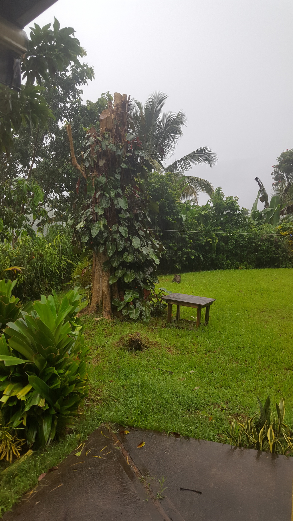
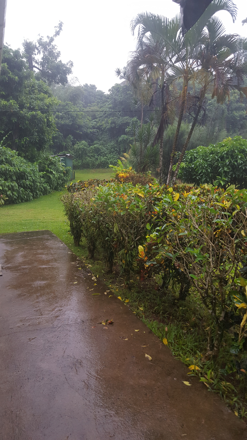
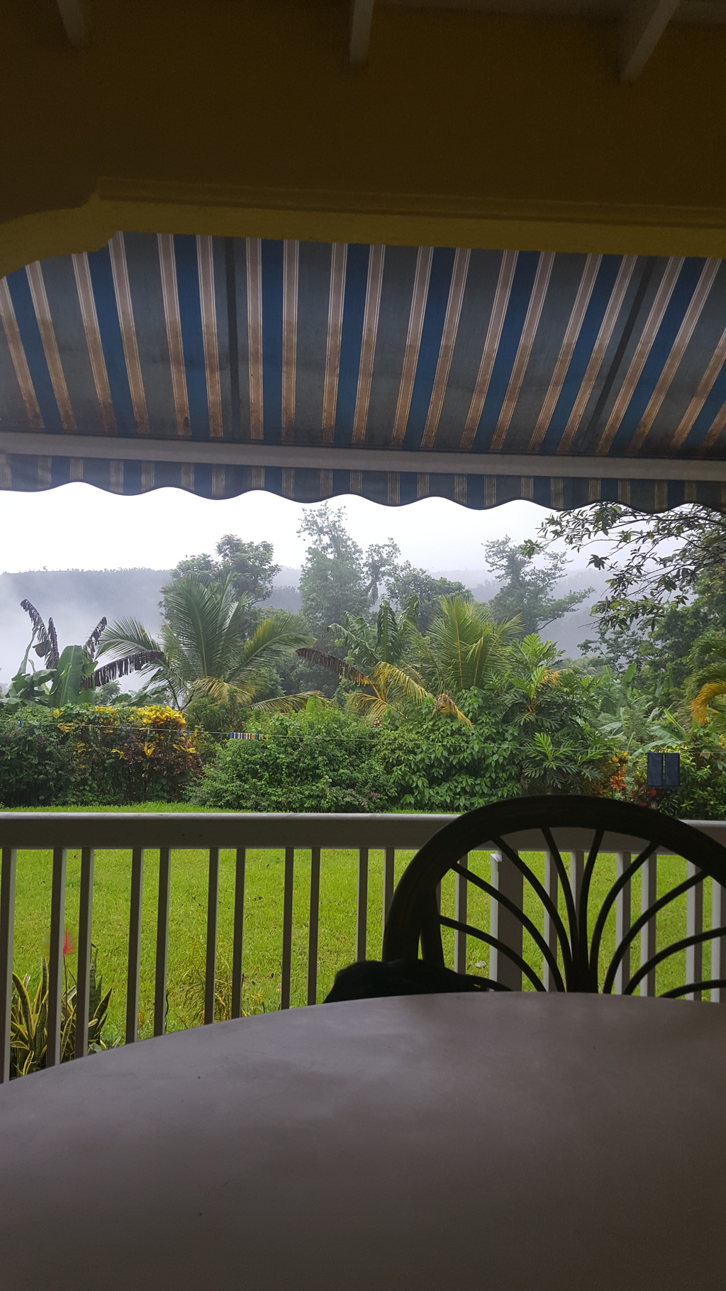
Some photos from our deck. Clouds coming off the Layou river below. Very eerie.
|
|
- Nasty Weather
|
- By Lisette Stevens <jaco.lass at gmail.com>
- Date: Wed, 30 Oct 2019 07:50:41 -0400
|
Wow, where has this weather come from! No name! We have woken up to a very dark morning with a great deal of grey skies and rain. Looking at the satelite picture weather maybe with us all day.
The river where we live was very full yesterday so I would imagine there will be flooding in areas that are prone to it and possible landslides.
If you do not need to go out today, it seems to be a day for being at home and staying dry and safe. |
|
- Hurricane Pablo- Reality of still favourable Probability
|
- By Micheal Colaire <nichs2002 at yahoo.com>
- Date: Sun, 27 Oct 2019 21:29:57 +0000 (UTC)
|
|
Well once again we have more solid proof that October is definitely NOT all over where Tropical development is concerned. The formation of storms -Olga and Pablo were a confirmation of this reality. The probability of Tropical storm formation remains a strong possibility well into November this season due to late season favourability. And this conclusive evidence has been even further solidified by the strengthening of Pablo to a Hurricane. And if the NHC is right the current intensity set at 80mph may even be modest despite it being at such a high latitude.
On the Local scene the Independence celebrations Continue in Grand style with night 3 of the World Creole Music Festival kicking off tonight. Buju and others rocked last night into the early morning... Amazing! The balance of Independence Week and Weekend ahead looks like it will be a fairly good one weather wise for the Nature Island. Although there is a tropical wave approaching the southern windwards which will need to have an eye kept on it... Nonetheless, thank God for His tremendous Mercies so far this Hurricane Season in the Windwards. & Let's continue to Keep safe & alert during the balance of this hurricane season everyone. |
|
- October Not All Over...
|
- By Micheal Colaire <nichs2002 at yahoo.com>
- Date: Sat, 19 Oct 2019 06:31:34 +0000 (UTC)
|
We had some rain overnight -early Friday morning, but that was pretty uneventful, thank God! Unfortunately, though based on radar estimates Guadeloupe to our north appeared to receive much more impacts from the rainfall which resulted in inundating low lying areas during the passage of 'ex 95L'. Gusty thundershowers also seemed to have affected the Antigua area as well... Some showers are still spreading across the island chain as the 'tail' of ex 95L pushes through into Saturday.Again The "Lesser antilles rule" definitely gave a boost to the convection of the system, and a sort of meso- centre (multi vortex core) circulation of low pressure was definitely showing up for some time on the Martinique radar to the West of the St. Lucia/ St. Vincent area.
Further, there was some under-estimation of this active disturbance especially as it initially seemed to become disorganised before reaching the islands. Its sad to hear about the damage caused by the southern axis of 'ex 95L' in south and Central Trinidad & Tobago. Hopefully, the impacts also felt in Northern Venezuela and Guyana were not too significant there. It just goes to show that much damaging impacts can still result from un-named (no name) tropical systems. Keep safe folks... & stay vigilant everyone. |
|
- Cyclogenesis possibility...
|
- By Micheal Colaire <nichs2002 at yahoo.com>
- Date: Thu, 17 Oct 2019 21:04:55 +0000 (UTC)
|
|
It looks like Fedaw and others including myself were really onto something... Apparently, a closed low level centre of circulation is trying to form right in the vicinity of St. Lucia. It is clearly visibly organising on the Martinique radar and its centre is very visible yet again on earth nullschool.net. Vigilance is required in the windwards this evening. Perhaps those potential tropical cyclone warnings may still be needed for the windward isles afterall... Also, to those in the gulf states please be on the alert as well.
|
|
- 95L
|
- By Lisette Stevens <jaco.lass at gmail.com>
- Date: Thu, 17 Oct 2019 14:23:36 -0400
|
How strange 95L is! Today in Dominica) is fabulous. The temperature is very tolerable, the rain on and off, really perfect conditions. 95L is rather weird in its progression. We will keep watching and see what happens.
Our Creole festival is around the corner and Dominica especially in Roseau very colourful. A lot of folks in Creole dress.
Guyana is not anywhere near the islands so is not affected by 95L. The rum punch here is very strong.
We will keep you posted. |
|
- Precaution...
|
- By Conan Shillingford <nichs at hotmail.com>
- Date: Thu, 17 Oct 2019 06:01:27 +0000
|
95L (or what's left) seems set to deliver some amount of weather to the windwards within the next 12-24hrs or so. Hopefully, the resultant hazards will not be too bad for the islands...
Currently, in Dominica we are getting into the thick of our Independence season with vibrant celebrations, and splendid heritage festivities in the truly gorgeous Nature Island of the Caribbean. Also, our Internationally acclaimed world Creole music festival
will be held at the end of October. Its a World Class 3-day exquisite celebration of Caribbean Creole culture; music, food and dance -not to missed, which takes place in the very heart of Roseau, Dominica. Book your calendars & Be there!
Weather-wise for the next day or so we expect that most of the rainy weather and thunderstorm activity will stay to our south. Re: 95L -The southern half of the axis of former 95L
may also need to be monitored which is probably likely to be the bearer of inclement weather when it approaches the Northern Guyana/ TnT area. Of course, accurately forecasting aspects of weak and small systems can be really problematic. However, if this (95L)
system can get aided by the 'Lesser Antilles rule' as it nears or crosses the island chain then the likely impacts such as flash flooding and storm force wind gusts from an enhanced, strengthening system could be pretty significant yet again for the islands
further south like Barbados, Grenada, Tobago, St. Lucia, & St. Vincent & the Grenadines etc.
Further future cyclonic threats also seem possible for the windwards in the coming week(s) according to some model projections as the 2019 hurricane season wraps up.
Keep safe and prepared everyone.
Sent from my Samsung device
|
|
- Eyes turned Eastward...
|
- By Micheal Colaire <nichs2002 at yahoo.com>
- Date: Fri, 4 Oct 2019 03:26:47 +0000 (UTC)
|
The system to our east seems to be trying to organise a bit, and the "Lesser Antilles rule" seems to be having some of its usual enhanced effect coupled with Dmax. We should get some of the showers showing up on radar by the early morning hours. This will be one tropical wave like so many prior to keep eyes on further down the road especially in the Caribbean sea. Let's pray and hope that this system does not go into any rapid intensification or organisation phase before approaching any land masses.
Keep safe everyone during this latter balance of the hurricane season...
|
|
- Heads up indeed...
|
- By Micheal Colaire <nichs2002 at yahoo.com>
- Date: Thu, 3 Oct 2019 04:23:16 +0000 (UTC)
|
It looks like there's definitely going to be some "weather" coming our way. If the GFS weather model solution holds sway some wet & possibly gusty conditions will affect the southern windwards and further north as the active wave which is approaching may have a split in its wave axis. Again only time will tell...
Hopefully, the "Lesser Antilles rule" does not lead to any significant strengthening and or convergence & increased organisation with this approaching wave. Sadly, the potential is there at this time of the year, and we certainly saw this play out with the Cyclogenesis of Tropical storm Karen.
Of course, Under-forecasted storms can be very problematic as they tend to be "under the radar" in respect of necessary prediction/ preparation, alertedness of authorities, and general risk reduction, and disaster management scope in the event of possible development of such systems- near or over the Lesser Antilles. Karen was the latest case in point, but will not be the last... Let's hope that this system & the one likely to emerge off the West African coast do not take too much advantage of the "Lesser Antilles rule" in the near future, potentially giving us any unwelcomed and unexpected surprises.
Let's all keep vigilant & prepared this season.
|
|
- Karen intent on keeling ...
|
- By Micheal Colaire <nichs2002 at yahoo.com>
- Date: Sun, 22 Sep 2019 11:20:20 +0000 (UTC)
|
Karen is flexing its strength with gusts of almost 50mph recorded in Barbados, which was greater than what was measured there at the airport during the passage of Dorian. Also, the system appears to want to imitate the unforecasted path taken by Dorian and move up the chain of islands towards the Puerto Rico/ V.I. region. Everyone in the Leewards, & V.I. needs to be vigilant especially if this storm rapidly intensifies. |
|
- We have Karen...
|
- By Micheal Colaire <nichs2002 at yahoo.com>
- Date: Sun, 22 Sep 2019 10:05:48 +0000 (UTC)
|
|
Well the following snippet below from the latest advisory on Tropical storm Karen pretty much sums it up... (We should expect a pretty long day ahead weatherwise into Monday). Let's pray and hope that its not too bad when all is said and done. :'At 500 AM AST (0900 UTC), the center of newly formed Tropical Storm
Karen was located near latitude 11.9 North, longitude 60.2 West.
Karen is moving toward the west-northwest near 9 mph (15 km/h) and
this general motion is expected to continue today. A turn toward
the northwest is forecast to occur on Monday, followed by a turn
toward the north on Tuesday. On the forecast track, Karen will move
across the Windward Islands this afternoon and tonight, and emerge
over the southeastern Caribbean Sea Monday morning. On Tuesday,
Karen is expected to approach Puerto Rico and the Virgin Islands...'
Let's also hope that this one does not do a 'Dorian' to the V.I. -as that system did strengthening just before landfall. Be on guard everyone.
|
|
- 99L's Rainy and Blustery periphery bands...
|
- By Micheal Colaire <nichs2002 at yahoo.com>
- Date: Sun, 22 Sep 2019 07:58:20 +0000 (UTC)
|
Well 99L has given the usual weekend party crowds a 'run for it' tonight as the heavens opened from early Saturday evening followed by some decent squalls. Fortunately, they were not too long lasting. However, if this is a sign of things to
come- from what may already be tropical depression 12 (T.D. 12), or worse as a named storm then we should take some serious precautions. I think its worth noting that judging from the most recent post from Trinidad and even Barbados earlier that
this is a particularly potent system already which is strengthening. Winds are still occasionally gusting to tropical storm force at the Grantley Adams airport in Barbados. We have already gotten a bit of our share here... with more to come.
Please stay safe no matter what, and everyone be prepared in the windward isles especially, and of course in the islands further north.
This potential Tropical Cyclone is expected to come up the Lesser Antilles chain by early Monday... Remain Vigilant.
|
|
- Monitoring...
|
- By Micheal Colaire <nichs2002 at yahoo.com>
- Date: Sat, 21 Sep 2019 06:41:56 +0000 (UTC)
|
|
The windward isles certainly need to keep an eye out for the possible development of 99L. This system could definitely affect all of the windward islands if further development occurs late this weekend according to the forecast. As with all systems that develop close to the islands ("The Lesser Antilles rule") resultant intensification is usually the case. Hopefully, if it does develop it will not be too strong of a system... An unexpected landfalling hurricane in the windwards would be last thing we need. However, given the current forecasts 99L has the possibility for some significant enough intensification though. Unfortunately, the weekend is a time when most persons tend to be less concerned about potential tropical threats. Praying and trusting that readiness and preparedness will be the watch words and
mantras of all in the islands as the tropical Atlantic continues to be active through September.
We'll see what Sunday into Monday brings. Keep safe and alert this weekend, & folks please be mindful that sometimes the biggest threat even from un-named systems remains their rainfall totals and the life threatening flooding damage which can occur as a result. |
|
- Providential...
|
- By Conan Shillingford <nichs at hotmail.com>
- Date: Sat, 21 Sep 2019 06:26:23 +0000
|
|
Thankfully it appears that the Northern Leewards caught a Luck break & escaped with no significant impacts thus far from weakened Jerry's close shave -apart from perhaps some swell activity. To God be the Glory, thank You Lord Jesus! Things could have certainly
been worse there. And this would have been the last thing particularly the V.I. would have needed especially since their suprise visit from Hurricane Dorian in August.
The so called "tail end" of Jerry could still produce some excessive rainfall though. However, whether that bears itself out remains to be seen over time.
Of course, we should probably keep a close enough eye on 99L as well. In fact, the weather models seem to show it affecting the windwards by Sunday.
It's not really over till 'the fat lady sings'... and there is still much of the hurricane season left to go. Let us continue to be prepared and as readied as possible- ever mindful that Precaution is always better than cure.
Let us remain vigilant and in preparedness mode especially given what is at stake in our vulnerable region, may we not take anything for granted.
& May God continue to Richly Bless our beautiful Caribbean region.
Sent from my Samsung device
|
|
- Closest Approach...
|
- By Micheal Colaire <nichs2002 at yahoo.com>
- Date: Fri, 20 Sep 2019 09:29:31 +0000 (UTC)
|
Category two hurricane Jerry will have its closest point of approach with the Leewards islands today. I think much of the Leewards should be on the look out for some inclement weather and elevated seas at least from the periphery bands of Hurricane Jerry as it passes to the north of the Leewards today. Hopefully not much worse will be experienced though its a distinct possibility... I quite agree that this fact makes the removal of the watch for Anguilla truly baffling. As always time will tell. We may even get some decent showers in Dominica once day-time heating and added convergence gets going with Jerry spinning so nearby. Perhaps the B.V.I Should be on alert as well given the proximity and projected path of the storm -given the fact that the Hurricane is not a point on a map or just its core.However, from earlier posts it seems like the U.S.V.I -STT in particular are taking some precautions which is laudable. Its Always better to be safe than sorry.
N.B. Hurricane Jerry Advisory Number 12 NWS National Hurricane Center Miami FL AL102019 500 AM AST Fri Sep 20 2019 ...JERRY EXPECTED TO PRODUCE HEAVY RAINS OVER THE NORTHERN LEEWARD ISLANDS AS IT PASSES TO THE NORTH OF THAT AREA LATER TODAY...
Keep safe everyone, & deepest condolences to all the families who have lost Loved ones so far this hurricane season especially in the Bahamas, and sympathies to SVG on the passing of our coreespondent from there. R.I.P. |
|
- Prudence & Precaution Always...
|
- By Conan Shillingford <nichs at hotmail.com>
- Date: Fri, 20 Sep 2019 08:44:03 +0000
|
|
Well, the Anniversary of super destructive Hurricane Maria has come and gone without too much fanfare or political diatribe- given the spur of the moment holiday decision on Thursday by the Government, which rubbed some employers wrongly. Of course, in
light of a looming general election- the usual political antics etc. are on full display. Notwithstanding, the Hurricane Maria anniversary Praise concert was pretty well received... We thank God for the remarkable recovery which has been made in the Nature
Island of the Caribbean, Dominica thus far. Truly amazing, yet May we never forget the lives of the many souls which perished in that catastrophic storm. & May their souls truly Rest in the Peace of Christ Jesus.
Nearer the home front, indeed, the 'Lesser Antilles rule' has certainly given some added strengthening to Hurricane Jerry which is now a strong Category two hurricane, and appears to definitely still be undergoing some amount of rapid organisation and intensification.
Further strengthening of this hurricane is definitely not out of the question particulary down the road in the forecast. Alarmingly however, the NHC (Thurs 8p.m.) mentioned that {The government of Antigua and Barbuda has discontinued the Tropical Storm Watch
for Barbuda and Anguilla.}...? Really SMH...
This appears to me to be a very premature & imprudent decision overall especially given the precedent set by this year's storms including the recent 'surprise impacts' by Hurricane Humberto in Bermuda, (Imelda in the gulf etc.).
Whatever models 'they' are following at the Antigua and Barbuda Met Office- they would do well to not subscribe to an over-reliance on model indicators; tracks & cones of uncertainty, and should err instead on the very sober side of caution. Especially if Jerry
should make any unexpected wobble or dip towards Barbuda and or Anguilla- it would have been in retrospect a very foolish & wreckless decision indeed given the circumstances. The Latest public advisory does state that tropical storm conditions will be felt
over areas of the Leeward islands by Friday as Hurricane Jerry makes its closest approach.
Further, this is truly a laughable irony with St. Maarten/ St. Martin currently under a tropical storm advisory and Anguilla the more Northerly neighbouring island being removed from even a storm watch. However, I trust that the people of Barbuda and Anguilla
will be prepared nevertheless for any potential storm eventualities. Irrespective of the resultant incompetence or imprudence of their met office, & or national authorities- Please Keep safe out there- we should all know better in the islands particularly
based on past experiences!
Lest we ever forget that various individual model runs are just one possible outcome from a myriad of potential ensembles & predictions. Weather does NOT always follow what is predicted on a whole or even what may be forecast for any specific area. Therefore,
Beware of limited or absolute model runs being insisted upon... There is always some measure of uncertainty for any potential track and intensity of any system that remains active. Thus, Weather forecasting remains with a healthy element of unpredictability...
bearing in mind that this is not an absolute science, which is just a fact.
Stay vigilant everyone. Thoughts and prayers continue to be with those affected in the Bahamas, in the Gulf states, and in Bermuda.
God Bless!
Sent from my Samsung device
|
|
- Anomalous Storms...
|
- By Micheal Colaire <nichs2002 at yahoo.com>
- Date: Thu, 19 Sep 2019 10:09:53 +0000 (UTC)
|
|
This year will certainly be one for thr record books. The major storms this year have been highly unusual to say the least- amd Bermuda's "brush" with Hurricane Humberto from all available accounts was way more than a brush and more damaging than was originally forecast. Again this is all highly consistent with Global warming predictions that storms and hurricanes will get more intense and have far more adverse effects when affecting land areas due to increased strength of hazards affecting land such as storm surge, flooding and associated wind damage. All of that coupled with baroclinic forcing aided by the upper levels (A strong midlatitude jet stream served to energize the storm) helped to give Humberto an added boost in strength as it went by storm seasoned Bermuda. And apparently according to the Bermuda Gazette so far a serious enough thrashing was given by the monstrously huge storm to the island which is connected by causeways.
Anomalous storms indeed- this was also recently epitomised by then post tropical Hurricane Dorian's devastating impact on Halifax Nova Scotia, which was supposed to have been weakening as it transitioned into an extra-tropical storm. Now this phenomena has again been incredibly portrayed by what appears to have been the "mother of baroclinic forcing" with Hurricane Humberto's brush on Bermuda, which resulted in a much more destructive blow to the island... Sadly this may be a growing trend with more northern lattitude Atlantic hurricanes. In fact Hurricanes Matthew & Nicole of 2016 were other cases in point which had devastating consequences on the North Atlantic region.
Also, Jerry is now almost a hurricane... Of course keeping a weary eye on this storm in the central isles. More on it a bit later. |
|
- Storm Projections...
|
- By Micheal Colaire <nichs2002 at yahoo.com>
- Date: Wed, 18 Sep 2019 05:01:58 +0000 (UTC)
|
All eyes should continue to be trained to the East of our Lovely isles especially with recently classified tropical depression 10 being on the verge of becoming Tropical Storm Jerry. & notably there are no guarantees in track or forecast for these types of systems unfortunately.
However, in keeping with a few of the projected tracks from the models so far- the expected track of *Pre- Jerry looks somewhat similar to that of Hurricane Jose of 2017. Jose of 2017 also had some rapid intensification occuring as it neared the Lesser Antilles. As of yet -I don't have a good feel about Jerry... Time will surely tell. Folks Please be prepared especially in the Leeward islands in case of any changes in its track. We have had some tragic surprises with storms before. This year let there be no avoidable loss of lives or even livestock in the event of any landfall and potential storm impacts.
On Tuesday some inclement Conditions continued during the morning hours but only very briefly. Monday's squally weather gave a lot more rainfall, though this was still not quite as much as the weekend's total. Therefore, of course, All of our rivers are running at peak volume and discharge (Non- flood stage), and our cascades and shimmering waterfalls are in their majestic glory.
This Wednesday is the immensely tragic anniversary of 'Super Hurricane Maria' which hit Dominica from the evening of the 18th of September, 2017- 19th September, 2017.
This anniversary falls within our Independence season celebrations, and consequently a Praise Concert has been planned on the 19th of September at the Roseau Windsor Park Stadium. Also, a public holiday has been declared in the observance of this special day of remembrance and thanksgiving for God's Mercies, Providence, Intervention and Remarkable overall recovery of this Nature Island of the Caribbean, The Commonwealth of Dominica. Perhaps this will prove even more providential as a collective holiday time to prepare accordingly- should what will be 'Jerry' give any significant effects to our island weather, or by any other system following on its heels. God Bless Dominica, & God Bless its beautiful & resilient people!
Let us also remember to keep the people of Bermuda in our thoughts and prayers as Hurricane Humberto makes it closest approach there... Stay safe and Prepared everyone.
|
|
- Talk about RI...
|
- By Micheal Colaire <nichs2002 at yahoo.com>
- Date: Tue, 17 Sep 2019 21:31:27 +0000 (UTC)
|
|
What is Now Tropical Storm Imelda went from having just about a 30 percent chance of development to a 50% chance, to being declared as Tropical depression eleven, and eventually to becoming the notorious "I" named storm in just a few hours this morning. This typifies Rapid Intensification (RI) indeed.
This simply re-inforces the need and rationale of keeping vigilant of potential tropical threats especially during the peak of the hurricane season. Much closer to home- Tropical depression 10 seems poised to become Tropical storm Jerry as soon as tomorrow morning at the latest. However, with its continued westward direction it seems almost guaranteed to affect the Northern Leewards unfortunately, and possibly all of the Leeward islands. Let's hope RI does not occur here as with Tropical storm Imelda. Of course, Hurricanes Irma and Maria of 2017 at a similar location were absolutely record breaking in their show of RI out in the Atlantic.
Let us All keep vigilant and Prepared this Hurricane Season... |
|
- Heads up Indeed...
|
- By Micheal Colaire <nichs2002 at yahoo.com>
- Date: Tue, 17 Sep 2019 15:38:34 +0000 (UTC)
|
|
Tropical Depression ten has formed well East of the Lesser Antilles... This is most likely 'Pre-Imelda' at this point. Given the forward track and the possibility that the cone of uncertainty may shift- all of the Leeward islands need to be on the lookout. Also, many more healthy tropical waves are lined up on the African continent so vigilance needs to be maintained in all of the Lesser Antilles during this second half of the hurricane season. I'll provide some added insights shortly Re: Dorian's Infamy in the island chain and the latest invests which already made the crossing into the Caribbean sea. |
|
- Stormy weather
|
- By Lisette Stevens <jaco.lass at gmail.com>
- Date: Mon, 16 Sep 2019 11:03:54 -0400
|
What to say about the weather! Over the last week it has been incredibly hot even here in our valley!! There has not been a whisper of wind either which has been very unusual! The night before last everything changed! The heavens opened, the rain fell and the thunder and lightning was explosive. The thunder was totally deafening! We had about three of these storms through the night and quite a lot of rain!
Last night we experienced rain and today we are having a lot of rain, on and off ghusty winds and thunder and not so much lightning. We have been told and also looking at the satelite picture that this weather could be in for the rest of the day.
At least it is a lot cooler. Hopefully there will be no flooding or landslides either and everyone will stay safe. |
|
- Watching Ex 96L and 97L (Pre Imelda?)
|
- By Micheal Colaire <nichs2002 at yahoo.com>
- Date: Mon, 16 Sep 2019 11:02:42 +0000 (UTC)
|
Well the 'Lesser Antilles rule' has hardly ever failed to materialise, & it has had a significant effect on tropical disturbances arriving in the Lesser Antilles. Ex 94L was no exception as it plowed over the central Lesser Antilles on Saturday Evening. The heavens opened and a spectacular Lightning display followed. It was enough to keep most of the weekend socialites indoors for the most part, & utilities experienced some minor surges & glitches as the system did its best to flex right over the central islands. Fortunately, there was no significant further development of that system.
This Morning Ex 96L is poised to do the very same as the work week kicks off. Already frequent showers have been occuring and everyone has had no choice but to join the 'Umbrella brigade.'
One always has to keep a weary eye on these tropical systens with potential for development especially around the peak of the Atlantic Hurricane season which spans from September into mid October. At the moment the African Continent is certainly churning out tropical disturbances with high frequency. & All eyes should be trained to the East of our Lovely isles especially on recently designated 97L. There are no guarantees in track or forecast for these types of systems.
Notably, the dreaded "I" storm is next. 'I' named storms tend to be historically notorious so it remains to be seen where Imelda will form and its eventual impact. - Ex 96 L looks to be mainly a rain- maker & hopefully nothing worse for the islands into Monday night. Although already its satellite appearance and overall convection as seen on the Martinique radar has been building somewhat. The Lesser Antilles rule certainly continues to favourably affect the strengthening & or enhancement of these systems particularly as they get past the 50W line. I have no doubt that the same will be true for 97L.Time will tell as to the potential for futher strengthening and impact of Ex 96L and 97L systems down the road especially as in the case of the former- it begins to enter the warm & somewhat favourable Waters of the Caribbean sea for this time of the year.
Stay alert and be prepared as we go through this peak of hurricane activity.
& Our heartfelt thoughts and Prayers continue to be with the people of the Northwestern Bahamas. Grateful to God that what is now Hurricane Humberto did not make landfall over your area. & God's speed on your continued recovery... We've been there, & in time You shall recover in Jesus' Name! Only have Faith & Persevere. With God nothing is Impossible; We are Caribbean Strong!
|
|
- Early Warning, Heads up...
|
- By Conan Shillingford <nichs at hotmail.com>
- Date: Sat, 14 Sep 2019 07:23:54 +0000
|
|
This is definitely the peak of the Hurricane season as there are several systems being tracked at this time...
Firstly, 96L still bears watching particularly as it begins nearing the islands by Sunday into Monday. The usual 'Lesser Antilles Rule' will kick in, which is normative in aiding intensification and overall development of these systems. The potential for
a tropical depression forming or worse is still significant. On the heels of 96L are two other disturbances being monitored for tropical development in the Eastern Atlantic. Soon to be designated 97L is expected to approach the Lesser Antilles as potential
cyclone by the next weekend. & a more southerly area of disturbed weather has formed which may head in a more westerly direction towards the windward islands unlike the other threats. Again as these systems near the Lesser Antilles chain their chances of further
development are expected to be significantly increased.
Based on the most reliable predictions for the path of these systems persons in the Northern Windwards & Leewards & persons with interests in the Northern Caribbean should monitor these systems closely in the coming week for tropical cyclone formation over
the next 5 days.
Keep safe & Vigilant Everyone...
Sent from my Samsung device
|
|
- Vigilance
|
- By Micheal Colaire <nichs2002 at yahoo.com>
- Date: Thu, 12 Sep 2019 07:03:33 +0000 (UTC)
|
|
With 95 & 96L as invests in the offing it appears that unfortunately both the Bahamas and the Lesser Antilles may have to be on alert for tropical development over the next few days into next week. Time will tell as per usual, however we are at the Climatological peak of the season when conditions are typically more favourable... Seas surface temperatures are higher, shear is not as abundant and the upper atmosphere is not as dry. The entire chain of islands from Trinidad northward need to be vigilant at this time & for the duration of this season.
Keep safe & stay prepared everyone |
|
- Good Riddance to Dreadfully Dangerous & Deadly Dorian...
|
- By Micheal Colaire <nichs2002 at yahoo.com>
- Date: Tue, 10 Sep 2019 21:04:11 +0000 (UTC)
|
With the winds of what was once Super Category 5 Dorian now finally silent over the North Atlantic tropical graveyard it is really imperative that a few things be penned in that regard...
In what was undeniably a record breaking Destructively Decimating, & historic Hurricane especially for the Bahamas to date -even now absolutely harrowing tales of the storm's wrath continue to emerge from survivors... On the ground particularly in Treasure Cay etc. And Great Abaco island etc. Sweeping voluntary evacuations of remaining residents are in the works- Post Hurricane Dorian. It is eerily reminiscent of the scenes in the Leeward islands with evacuees impacted by Monster hurricanes Irma & Maria back in 2017.
Dorian's impacts still graphically displayed on social media have been simply Breathtakingly chilling, and portend an immensely ominous warning and a highly disturbing omen of what could become a new normal, God forbid, universally, but in particular within the wider Caribbean region. With Dorian tying as the strongest ever landfalling hurricane in modern history along with the great Labour day hurricane of 1935 -sadly, unsurprisingly shocking & hugely catastrophic devastation has resulted across the north western Bahamas. Indeed, the onslaught of Hurricane Dorian over the last few days particularly in the Northern Bahamas has been unreal to say the least. Its truly incredulously mindblowing and an unthinkable disaster in scale. In fact, Josh Mongerman of icyclone has stated that Dorian was potentially the most violent cyclone he has ever documented. Its ferocity being unmatched except by perhaps only Super Typhoon Haiyan/ Yolanda in (2013) in the Phillipines.
Now a post storm human catastrophe continues to unfold. More help cannot get to the completely devastated shores of the Bahamas quickly enough. This is truly a disaster of historic & massively epic proportions. The Bahamian Prime minister was right in saying that this storm has created 'generational devastation'. Some 'guestimates' from locals taking into account the extent of the extreme impacts from unabated storm surge; unfathomable flooding and destructive winds have put the estimated death toll into the hundreds at the very least, if not thousands. Only time will tell regarding the actual death toll , however, there are many apparently credible eye witness accounts which detail that countless scores of bodies may have been washed out to sea. & Reports have emerged of persons who swam for their dear lives through estimated hundreds of floating bodies scattered among the expansive debris field during the eye, and in particular during the immediate aftermath of the hurricane. Consequently, the numbers of the missing are expected to be just as staggering as the bodies that are eventually tallied.
Certainly, our thoughts and prayers are with the people of the Bahamas -especially the North Western Bahamas, We are Caribbean strong! Sincerest & heartfelt condolences and sympathies go out to all those affected in the North Western Bahamas. Hurricane Dorian has been a truly mind-blowing, heart-wrenching & absolutely unbelievably apocalyptic experience in the Northwestern Bahamas. And ongoing psychological services will be required for children as well as adults especially for those who remain in denial. Even for the mere distant observer like myself there is still an element of Shock & awe regarding the magnitude and duration of the impact and resulting catastrophic devastation experienced there especially in Abaco island.
Having had the all too bitter experience of category 5 hurricane Maria almost two years ago- our devastation spanning a total period of over 8hrs pales in comparison to the 22+ hours of hurricane force wind/ surge impact by then Category 5 hurricane Dorian. The sheer length of time of impact is mind-boggling to say the least. Only Category 5 Hurricane Mitch's impact on the Honduran coast in 1998 comes close to Dorian's, and even then Mitch did not remain entirely stationary over any one point during that period. Also, Grand Cayman's impact from Category five Hurricane Ivan in 2004 was mercifully for a much shorter period of time.
Thus, for most residents of the North Western Bahamas It has simply been a nightmarish, deadly & Terrifying tale of relentless destruction during Dorian's landfall... insane.
This is just totally unprecedented meteorologically in modern recorded history- & upon review of the season for analysis at year's end- the intensity of the great Labour Day hurricane (1935) could yet be surpassed by catastrophically Devastating Hurricane Dorian.
Keep safe & Prepared for the balance of this Hurricane season Everyone. |
|
- Anniversary 24 years ago.
|
- By Lisette Stevens <jaco.lass at gmail.com>
- Date: Thu, 5 Sep 2019 15:04:05 -0400
|
24 years ago 1995 hurricane LUIS hit Antigua. Category 4 hurricane. Sustained winds 140 mph gusting at 200 miles an hour.
We were in our home in Hodges Bay from 6.30 pm Monday night until 9.36 am Wednesday morning. We got out for an hour mid day Tuesday when the eye went over us.
LUIS was terrifying. Worst to us than Maria as it went on for so long just like Dorian in the Bahamas.
We are thinking sincerely of the Bahamas now. We pray there are no more bad hurricanes this year.
God bless everyone in the Bahamas and around the world. |
|
- Hurrican Dorian Cat 5
|
- By Lisette Stevens <jaco.lass at gmail.com>
- Date: Mon, 2 Sep 2019 07:25:20 -0400
|
I did not sleep well last night. Jaco Ladd and I were in Antigua when Hurricane Luis visited in 1995. Luis was a very slow moving hurricane Catagory 4. He was with us from 6.30 p.m. Monday night and left at 9.36 a.m. Wednesday morning! It was horrific. The fact that Dorian is a Catagory 5 with 185 mile winds is totally unthinkable for us! Dorian is travelling very slowly and it is reported could be in the Bahamas for 30 hours.
We are very frightened for the islands in the Bahamas, we dread to think of the devastation and the outcome of this very tragic hurricane Dorian.
It appears to be pot luck where Dorian will head after her visit to the Bahamas.
We are praying for everyone. |
|
- Praying
|
- By Lisette Stevens <jaco.lass at gmail.com>
- Date: Sun, 1 Sep 2019 14:30:42 -0400
|
|
We are so upset for the Bahamas and anyone in Dorian's path. Hurricane Maria was terrifying. We cannot imagine what everyone is going through. Our hearts go out to everyone. Really sad.
|
|
- Dorian Gone
|
- By Lisette Stevens <jaco.lass at gmail.com>
- Date: Wed, 28 Aug 2019 09:14:34 -0400
|
It rained hard a lot of the day yesterday. We stayed home and relaxed. We lost electricity and wifi at 9.0 am and the eletricity and wifi came back around 4.15 p.m.
I heard of a landslide at Morne Prosper in the Roseau valley but not much else which is good.
We hear that Martinique had a bad time with rain and flooding. This is very sad.
Today it is overcast ad quite chilly, there are claps of thunder. We are beginning to see blue sky and white puffy clouds.
Hopefully Dorian does not do too much damage on her way to the other islands. |
|
- Dorian
|
- By Lisette Stevens <jaco.lass at gmail.com>
- Date: Tue, 27 Aug 2019 16:19:23 -0400
|
4 years ago to the day we had Tropical Storm Erika rain on Dominica! Today since 8.30 am Dominica has had very heavy rain, especially here in the Layou Valley. It has been truly horrible. Dorian has dumped a lot of water on us! Rain, rain and more rain. As I write this at 4.06 pm it is still grey and raining!
Nobody here thought we would have a bad time with Dorian, he was headed over Barbados, St. Vincent and St. Lucia, maybe Martinique!!
Everyone went to work!! Well after 1.30 pm people were told to go home from work and stay safe.
Our electricity went off at 9.0 am! Domlec the electric company have been amazing and we just have electricity back at 4.0 p.m. We now have internet.
We have not heard of damage to the island yet, but no doubt the rivers are full and there may have been some landslides.
I will report tomorrow.
Our dogs have been snuggled up all day, sleeping like babies!!
We hope everyone is safe here in Dominica and the other islands. |
|
- Dorian
|
- By Lisette Stevens <jaco.lass at gmail.com>
- Date: Tue, 27 Aug 2019 07:16:23 -0400
|
We all hunkered down for the night. Our three dogs were particularly quiet. We took the precautions of shutting our shutters. It was a very peaceful quiet night. A couple of heavy showers that is all.
We got up at 6.15 am to a very grey cloudy morning, it is raining quite hard at the moment. We have been told to expect heavy showers and wind through out the day.
It is a weird reminder of this day 4 years ago when we had Tropical storm Erika.
We so hope that Dominica does not get a great deal of rain today! People must still take precautions.
We have not heard any news from any other islands we hope everyone is OK.
It is pouring rain now and very, very dark. I will keep posting if I can throughout today.
Stay safe everyone, |
|
- Approach...
|
- By Micheal Colaire <nichs2002 at yahoo.com>
- Date: Tue, 27 Aug 2019 03:43:26 +0000 (UTC)
|
As Dorian makes his approach through the windwards its expected to get more blustery, but hopefully not much more will be experienced in Dominica. So far from the appearance on radar it looks like Dorian has given some stormy conditions to most of Barbados...At the moment its getting a bit breezy as the first periphery or outlier band of rain comes through. However, its pretty light and we're thankful, and hopeful that it will stay that way into Tomorrow in the Nature Isle of the Caribbean. Keep safe everyone & God Bless! |
|
- Dominica
|
- By Lisette Stevens <jaco.lass at gmail.com>
- Date: Mon, 26 Aug 2019 14:33:46 -0400
|
Everyone here is being warned big time to stay home. To be safe in case the storm becomes like Erika which was in Dominica 4 years ago tomorrow! Every one is really being very careful.
We are all taking this very seriously.
The weather in the world now is so unpredictable. Precaution is a must.
Here in the valley it is very hot and still. Not a good sign.
We pray for all the islands affected by Dorian. We hope everyone stays safe. |
|
- Dorian
|
- By Lisette Stevens <jaco.lass at gmail.com>
- Date: Mon, 26 Aug 2019 09:04:09 -0400
|
Dorian is going to visit Barbados! We hope that things will not be too bad for them. Also continuing onto St. Vincent and will maybe touch St. Lucia. Here in Dominica we will probably get rain and wind but it looks like we are lucky not to have Dorian heading our way for a visit on the nose!
We are all here in Dominica being warned about Dorian and everyone is being told to make sure they are safe over the next two days.
We chose to do a shop yesterday, it was such a pleasure there was no one on the roads and the shopping was easy. The parking too. What a lesson we learned.
Everyone keep safe especially our other friends on the islands that will be affected directly by Dorian. |
|
- On Alert...
|
- By Micheal Colaire <nichs2002 at yahoo.com>
- Date: Mon, 26 Aug 2019 09:42:29 +0000 (UTC)
|
|
Well we remain under a tropical storm watch from last night. Its a wait and see situation at this point... Hopefully, conditions won't be too bad here. If things do get more intense weather-wise I'll report accordingly. We're expecting the usual squalls, however, every storm is unique and a compact system like Dorian which is strengthening could have some surprises. Again the 'Lesser Antilles rule' is into full effect- beware to all who are in the path of Dorian including those likely to be affected by its periphery and feeder band activity further south. The system is still maintaining a westward motion for now. Precaution is alwayd better than cure indeed.
God Bless our island people! |
|
- Tropical Storm Dorian
|
- By Lisette Stevens <jaco.lass at gmail.com>
- Date: Sun, 25 Aug 2019 08:09:49 -0400
|
Watching the progress of Tropical storm Dorian we notice that he is staying south and could hit Barbados before moving to the other islands. St. Lucia could be in line but hopefully Dominica and Martinique will be side swiped and not too badly hit!! There is still time for Dorian to change track, however, at the moment it looks like Dominica may not be too much in his path! Fingers crossed.
We still have to make sure we have everything in hurrican cupboards. Food, batteries, fuel for the generator, full tank of gas in the vehicles. Take all necessary precautions.
Tuesday through to Wednesday looks to be the time scale for the islands to be hit. |
|
- All eyes to the East...
|
- By Micheal Colaire <nichs2002 at yahoo.com>
- Date: Sun, 25 Aug 2019 05:44:49 +0000 (UTC)
|
Well, as anticipated and feared Tropical Storm Dorian has formed... According to most of the weather models the consensus is for a strengthening Dorian to pass to our south by about 50 miles.. But that is way too close for any comfort and any slight wobble or jog by the centre could put it directly over us.Historically, there are certain letters which have a bad hurricane season precedent overall for the islands, and the letter D is definitely one of them. For Dominica in particular- before the unprecedented damage caused by Hurricane Maria (2017); it was hurricane David that was our worst hurricane back in 1979. Also, hurricane Dean though not anywhere as bad as David was damaging enough to the central windward islands back in 2007. Hopefully & prayerfully Dorian will not be a hurricane when it crosses the island chain in a couple of days. All efforts at preparedness and readiness should be in high gear across the island chain.
Keep safe & vigilant everyone. God Bless! |
|
- Weather watching
|
- By Lisette Stevens <jaco.lass at gmail.com>
- Date: Sat, 24 Aug 2019 15:54:32 -0400
|
We have been lucky so far this hurricane season. 99L is approaching and we are all being very watchful. This system could become a tropical storm in the next couple of days.
We here in Dominica have to be very wary and make plans to stay safe. Make sure we have everything necessary in place.
We have been enjoying good weather so far this hurricane season. Rain at night mostly, good temperatures.
We will keep a watchful eye and report over the next few days. |
|
- Heating up...
|
- By Micheal Colaire <nichs2002 at yahoo.com>
- Date: Sat, 24 Aug 2019 14:39:38 +0000 (UTC)
|
Things are definitely beginning to heat up across the tropical Atlantic basin... Let Us be thankful though for the prolonged break in tropical activity thus far. However, this Tropical disturbance low (invest 99L) needs to be closely monitored indeed. This system could strengthen quite quickly enough if the wind shear lessens and more favourable conditions kick in with the dreaded 'Lesser Antilles rule.'Let us not take anything for granted, because we certainly do not need any repeats similar to that of Category 5 Hurricane Maria's rapid intensification back in 2017. May our Lord & Saviour Jesus Christ grant protection and deliverance to the Nature Isle of the Caribbean & our sister isles.
|
|
- Cool
|
- By Lisette Stevens <jaco.lass at gmail.com>
- Date: Thu, 8 Aug 2019 15:11:08 -0400
|
Dominica has been spared from any bad rain. It has been cool and sweet to us. Long may it last.
Just hope the season is cool. No hurricanes, enough rain.
Let's hope we have a great weekend weatherwise. |
|
- Wet...
|
- By Micheal Colaire <nichs2002 at yahoo.com>
- Date: Thu, 8 Aug 2019 04:04:06 +0000 (UTC)
|
We had some rain showers which will probably continue with a lesser intensity into the early morning as was forecast along with some rumbles... All seems to be well in my area thank God. Praying and trusting that all is well on the other islands being affected as well. So far so good for this year's hurricane season.
May God Bless our Lovely islands. |
|
- Lovely evening
|
- By Lisette Stevens <jaco.lass at gmail.com>
- Date: Wed, 7 Aug 2019 18:20:46 -0400
|
No rain for over 2 hours, lovely and calm.
It would be great if the Tropical wave misses us.
Is this the lull before the storm, hopefully not.
Dogs and me chilling on the deck, frogs singing so sweetly. All is quiet. Long may it last.
Every one just stay safe and just maybe we will be spared.
|
|
- Tropical Wave
|
- By Lisette Stevens <jaco.lass at gmail.com>
- Date: Wed, 7 Aug 2019 16:18:36 -0400
|
Looking at the satellite just now it looks like we are in for some wet hours to come.
We hope that there is not too much rainfall as the ground here is already very sodden.
Today has been very dry and bright. The sun has gone now, the temperature has dropped and it is hazy in the valley.
I am also warning people not to come up from Hillsborough bridge to Ponte Casse. The road just below us is very bad indeed. You can only come up it with four wheel drive.
Take care everyone over the next 24 hours.
It is just starting to rain heavily it is 4.18 pm
|
|
- Glorious Sunshine...
|
- By Micheal Colaire <nichs2002 at yahoo.com>
- Date: Mon, 5 Aug 2019 13:48:33 +0000 (UTC)
|
|
The sun has been able to finally peep through and conditions are settling nicely as the day moves along. Today is our National Emancipation day observance in Dominica so the weather should cooperate sufficiently for all of the planned activities. A Very Happy Emancipation day Holiday to All in the Nature Isle!
& May God richly Bless us All!
|
|
- Till the Fat Lady...
|
- By Micheal Colaire <nichs2002 at yahoo.com>
- Date: Mon, 5 Aug 2019 09:36:42 +0000 (UTC)
|
|
Well, we've had mostly moderate showers with the passage of 96L thus far. Its a Blessing that there has not been anything worse weather-wise since there was a lot of potential for 96L to be quite potent upon its passage through the islands.
However, based solely on the radar imagery it appears like it may still want to make an attempt at intensification. (Its not over till the Fat Lady ...) In fact, Perhaps cyclogenesis may be occuring now, or it may also happen in the near future on its trek through the Caribbean sea if conditions are more conducive than they are at present.
Keep safe & Vigilant Everyone. |
|
- Precaution better than Cure...
|
- By Micheal Colaire <nichs2002 at yahoo.com>
- Date: Sun, 4 Aug 2019 21:17:27 +0000 (UTC)
|
|
We had some on and off showers yesterday, however, it appears that as the new week begins we may have much more inclement weather associated with the passage of what is likely to be Pre- Chantal.... Hopefully it won't be too rough. Nevertheless, it seems that 96L has definitely been strengthening of late, and more intense convection is wrapping nicely around its centre of circulation...
Organisation has certainly been improving as the 'Lesser Antilles rule' becomes more apparent. Its satellite appearance is a lot more symmetrical now compared to its less than impressive imagery a few hours ago. At the moment 96L is definitely showing increased vorticity, and as its spin becomes more evident- its closed low level center of circulation is also becoming fully establised. Extra vigilance, and consideration of early issuance of Potential tropical Cyclone advisories should be considered at this point.
Interestingly, the forecast models seem to have a better handle on the track of 96L now, which most closely matches their earliest track projections. Again its well worth noting when sites like Windguru give a solid indication of severe tropical weather way in advance. Its likely to materialise...
Unfortunately, this tendency by the NHC et al to pre-maturely & imprudently downgrade the percentage of likely development of a threatening tropical system -although its climatologically favoured to develop just east of the islands still exists, & this needs to stop. Were it not for the downward phase of the convectively coupled Kelvin wave (CCKW), which is suppressed- over the Caribbean region this disturbance may have been a named system already. Thank God we have been spared this time, however, things are expected to get much more active by mid August.
In fact, an abundance of cases in point exist that refutes this rationale... And one need not reference the hellish year of 2017 with the rapid intensifications of Irma & Maria all too fresh in our memories. Additional notable examples though of under-forecasted tropical cyclone development include Cindy (1993), Debby (1994), & Tomas (2010), which were all missed for their potential and evolving cyclogenesis in favour of a meteorological bias & dependency on the weather models. Flare ups with 96L are still likely and it looks likea new center of circulation has re-formed north east of Barbados nearer Martinique. Time will tell... development may still be possible down the road either Let's All stay ready and Prepared come what may.
|
|
- The Tricky yet Indomitable 'Lesser Antilles Rule'...
|
- By Micheal Colaire <nichs2002 at yahoo.com>
- Date: Sat, 3 Aug 2019 10:19:16 +0000 (UTC)
|
Despite problematic predictions from the weather models of late, the likely outcome for 96L is almost certain as it nears our chain of islands. As with 95L, it is almost guaranteed that 96L will steadily build in its convection, organization and vorticity just as its already doing as it slowly advances towards the Lesser Antilles... And one can definitely look for an increase in the system's intensity as occured with 95L's passage.
As has been well documented with the following examples of near island Tropical system development-i.e. Helene & Rafael in 2012, Gonzalo- 2014, (Erika- 2015), Matthew- 2016, Bret & Maria- 2017 etc.
The 'Lesser Antilles rule' generally kicks into effect once tropical disturbances arrive at the 50W-55W Line of longitude which generally results in greater convergence- at times resulting in rapid intensification; enhanced outflow & subsequent cyclogenesis. The case with 96L appears to be no different.
Let's see whether greater meteorological prudence & proactivity in the interest of life and property in the islands will prevail by the activation of the Potential tropical cyclone advisories. This should be done sooner rather than later in my view. Time will surely tell...
Let us all continue remain vigilant & Prepared this Hurricane season.
& May God Bless all of our islands! |
|
- Grey
|
- By Lisette Stevens <jaco.lass at gmail.com>
- Date: Fri, 2 Aug 2019 17:22:46 -0400
|
The rain has stopped and it is fairly bright but lovely and cool.
The satellite picture shows the system over us but it seems very gentle. Let's hope it continues to stay this way. It is 5.21 pm. |
|
- RAIN
|
- By Lisette Stevens <jaco.lass at gmail.com>
- Date: Fri, 2 Aug 2019 16:35:35 -0400
|
Here in Dominica we are experiencing heavy rain. We see the Tropical wave on the satellite.
To be honest we were surprised.
Everyone stay safe, it could be a rainy night. |
|
- Fair Weather being enjoyed... Activity brewing
|
- By Micheal Colaire <nichs2002 at yahoo.com>
- Date: Thu, 1 Aug 2019 01:32:20 +0000 (UTC)
|
|
Thankfully, we are back to sunny skies and fair weather conditions in the Nature Isle. What was a really soggy Sunday courtesy 95L gave way to gloriously fair weather thus far this week. Its really unfortunate though that 95L has caused so many impacts in the Guadeloupe & St. Martin/ St. Martin area as well as in the Virgin islands/ Puerto Rico region. However, apparently, this may tragically be a sort of precursor to potentially severe weather which may arise from what is now 96L and is likely to become the third named system of the Season so far (Chantal).
Busy Tropical Weather seems to be ahead as we enter in the climatological peak of the hurricane season. As the tropics heat up, let us All continue to be prepared and vigilant come what may...
May God Bless our beautiful islands.
|
|
- Tropical Wave
|
- By Lisette Stevens <jaco.lass at gmail.com>
- Date: Sun, 28 Jul 2019 17:24:33 -0400
|
I am writing this at 5.15 p.m. The weather all day has seen heavy showers. Now it is pouring rain so bad we can hardly see across the garden.
We are now worried about flooding and landslides especially if this weather continues through tonight.
We suggest anyone who is living anywhere near a river or anywhere prone to landslides. Moves now.
The Tropical wave looks like it could be in for the night.
Please everyone stay safe.
|
|
- Tropical Wave
|
- By Lisette Stevens <jaco.lass at gmail.com>
- Date: Sun, 28 Jul 2019 08:27:14 -0400
|
Sitting on our deck at 8.0 a.m. It is very grey and raining heavily. We also are hearing a lot of thunder. Our dogs a curled up in their beds asleep. It looks like it is in for the day.
Hopefully, everyone will be careful today.
It is cold too, unusual. The garden will enjoy the rain.
We hope everyone stays safe and dry. Some folks still have no roofs only tarpaulins since Maria. Very sad.
So far the weather here is not too bad. In Europe and the UK. They have been sweltering, it seems climate change is a reality.
|
|
- Small earthquake
|
- By Lisette Stevens <jaco.lass at gmail.com>
- Date: Thu, 25 Jul 2019 08:51:01 -0400
|
We were woken up with a jolt and hearing our plates rattling in the cupboards. It did not last very long at all but it was enough to wake us up at 6.20 a.m. Apparently it was 5.2 on the richter scale!
We also are experiencing a Tropical wave, so it is cloudy and a good temperature. It rained quite alot in the night. At the moment it is quite pleasant.
We are watching the very high temperatures in Europe and England. We in the Caribbean are used to high temperatures. It seems like the weather has changed a bit and we are a bit cooler.
Hopefully today will not be too bad but we should all be watchful and take care. |
|
- Blow me away
|
- By Lisette Stevens <jaco.lass at gmail.com>
- Date: Mon, 15 Jul 2019 11:35:26 -0400
|
What a very fresh day! The wind is totally amazing! The sun is shinning. Our dogs are loving the weather, they are lying in the sun which normally they would never do because of the heat! With the wind so ghusty the temperature is perfect for lying in the sun with a fur coat on!! LOL
We went to the river yesterday, we love going, to soak in the river, we like to go at different times in the day! Yesterday, it was apparent that the tropical wave had affected us as there were a lot of logs on the river bank and a very large one in the river itself. The one thing we love about the river is that it is alive. The river alters a little everyday. When there is a storm or weather the rocks have changed places rather like a slow dance. Sitting watching the wild life! We see parrots, egrets, hawks and many other birds plus the odd Aguti!! It is truely awesome! Dominica is so beautiful, she is slowly recovering from hurricane Maria.
We have a lot of avocados on our tree outside our home, it is the first real crop since hurricane Maria! We hope the wind does not bring them down!!
We have noticed this last year that we are experiencing alot more wind and in many ways it is good for the temperature.
We are keeping watch and hope for the best this season with few storms or hurricanes and little damage!!
This is an Aguti, they are lovely and live wild here in our valley.
My painting of a baby Jaco parrot. 

|
|
- Gentle
|
- By Lisette Stevens <jaco.lass at gmail.com>
- Date: Sat, 13 Jul 2019 14:37:56 -0400
|
The tropical wave has been very gentle in the Layou valley. The night and early morning was heavy rain. Since then grey sky's cool day. Very pleasant.
Having checked the satellite photo, we could get a bit more rain tonight but it looks like it is clearing.
So happy. The rain is good. Life is good.
|
|
- Tropical Wave
|
- By Lisette Stevens <jaco.lass at gmail.com>
- Date: Sat, 13 Jul 2019 08:37:08 -0400
|
We have woken up to a very grey dreary day. It has been raining a lot in the night and this morning is very dull and there is a lot of moisture around. Looking at the satelite it looks like this is in for the day big time!
Today is a day to stay home and stay safe. I think we will watch Wimbledon.
We are now stocking up big time our hurricane cupboard and remind everyone to do the same. When hurricane Maria hit we could not get out from our home for 15 days and luckily we had enough supplies to be fine until we were able to leave the valley.
With those memories still fresh in my head I sincerely hope that we do not have any bad hurricanes in the Caribbean. I am not sure how any of us would cope again. It took over 3 months to get any fresh vegetables or any real suppliies.
Everyone take care today and if you live near any rivers or anywhere that are prone to landslides be very wary and maybe move to a safer location. |
|
- Keeping a wary eye on Systems...
|
- By Micheal Colaire <nichs2002 at yahoo.com>
- Date: Fri, 12 Jul 2019 10:39:30 +0000 (UTC)
|
The forecast for 93L is a classical one for this time of year, and given that we are in a sort of weak el nino year as well... It will be interesting to see what happens development- wise over the weekend. Models have been largely conservative in their development of the system, but again time will tell. According to the latest forecast guidance (TT Weather center) "93L is caught up in a strong flow of easterly trade winds, and will continue to the west at 15 – 20 mph for the next five days or so. This will bring the disturbance into the Lesser Antilles Islands by Monday evening, and will also act to impede development, since fast-moving tropical waves have more difficultly aligning themselves vertically and getting organized."
However, history, & our personal experience in these islands have taught us quite well that these systems do have a mind of their own... In fact, rather surprising development or rapid intensification can occur inspite of dry air, saharan dust and even wind shear/ forward speed etc. Ideally, increased organisation of these systems is usually likely by 55W. I have noticed that Most systems tend to slow forward speed somewhat by that location, and this phenomenon allows for more vertical stacking, increased organisation & enhanced vorticity. This typically results in a more defined Low level circulation & a stronger system nearer the islands whether or not its a named system by then. So we shall see what really unfolds over the next couple of days.
Tropical wave 19 is currently pushing across the southern windwards is already causing significant convection activity in the area. We'll have to wait & see if any further development happens once it gets into the usually hostile Caribbean sea area down the road.
Continue to Keep safe everyone & God Bless!
|
|
- 'Lesser Antilles rule' Potentials
|
- By Micheal Colaire <nichs2002 at yahoo.com>
- Date: Thu, 11 Jul 2019 05:05:25 +0000 (UTC)
|
|
Wishing all the best to those in the Gulf states who may be facing the fury of PTC2 (Potential Tropical Cyclone 2) or Pre- T.S. Barry.
Hopefully it will not be a very destructive system. I think we in the Lesser Antilles Islands may have a real enough threat of our own not too far down the road with two potentially threatening tropical systems in the Atlantic. They may not seem like much now, but as Always once they near the islands, slow forward speed and get a chance to enhance their spin; convergence, low level circulation & overall intensification with more favourable water temperatures -cyclogenesis usually follows.
So far gorgeous weather & Lovely sunny skies to be enjoyed here in the Nature Island of Caribbean; Dominica. Let Pray & hope that we are all prepared by this point in the 2019 hurricane season. Possibly the impacts from potential July systems may not be so damaging...
Be pro-active always & Keep safe this hurricane season everyone. & May God Bless our Caribbean Region! |
|
- Tropical Wave
|
- By Lisette Stevens <jaco.lass at gmail.com>
- Date: Thu, 20 Jun 2019 07:42:04 -0400
|
Dominica on the whole over the last few days has had pretty good weather! The temperature is very tolerable for this time of year! Usually when we go to Roseau which is two or three times a week it is really hot but for this week it has been very comfortable in fact a bit overcast. Going to Roseau during the summer months can be very uncomfortable heat wise and one tends to want to get in and out as quickly as possible!
This week here in the valley has been really lovely rain, sun and a lot of wind keeping us very cool. The garden is loving the moisture.
One of the things that is particularly wonderful to us is that we are hearing and seeing a lot of parrots. It is so wonderful to have them back. After hurricane Maria we never thought that the parrots would survive, it was tragic and yet the other day we had a family in a tree close to our home a Mum and Dad and two babies!
Yesterday we had rain come in around four and it has been raining on and off but all good.
The only thing that we notice and in a way find strange that most days at some time we get a great deal of wind, really gusty, I wonder if any of the other islands notice that it is pretty windy at some point in the day. Maybe it is just because Dominica is so mountainous. We have noticed it more over the last year and a half.
We so hope that the hurricane season is very mild and very kind to all of us in the Caribbean. |
|
- Earthquakes
|
- By Lisette Stevens <jaco.lass at gmail.com>
- Date: Sat, 15 Jun 2019 15:36:21 -0400
|
Hi there! Dominica since 10.00 p.m. last night has as far as we know had about five earth tremors! It is 3.27 p.m. we have just been told that there has been one just now!
Here by us we have been lucky, we have felt nothing.
Our dogs woke us up 4 times in the night. They were howling more than barking so maybe they felt the tremors.
We are all hoping they stop.
It is Father's day tomorrow! Maybe there is a message somewhere! LOL.
We have had a lot of rain today. It has been very pleasant temperature wise. The dogs are loving it. So are we.
Dominica is beautiful. We have so many parrots living by us it is awesome.
Happy Father's day tomorrow all you Daddies. X |
|
- Thunder and Lightning
|
- By Lisette Stevens <jaco.lass at gmail.com>
- Date: Sat, 8 Jun 2019 10:31:54 -0400
|
Well, I woke up to a flash of lightning at 4.20 am!! I literally leaped out of bed, took all the plugs out of the wall, switched the electricity off. One thing that we learned by experience is that if the lightning strikes the house and the computer or anything is still plugged into the electricity you completely damage the computer. We learned the hard way!
The weather now is really great, the sky is grey and it is really cool. The dogs are all asleep and comfy.
This weekend is a bank holiday and we are planning a easy weekend.
Dominica is looking green and a lot of the trees are looking so much better. We have a lot of parrots around now too. We also have tree frogs, which sing to us when it rains and in the night!
We are incredibly lucky where we live in the country. We are growing strawberry's which are delicious. We are surrounded by green, our dogs are all asleep at the moment, life is good.
|
|
- Hurricane season cometh!
|
- By Lisette Stevens <jaco.lass at gmail.com>
- Date: Sun, 2 Jun 2019 08:47:02 -0400
|
What a day yesterday was! 1st June, the electricity goes off around 6.0 am! We get up and I turn on my phone and there is no internet on my smartphone! (not so smartphone!!)
What a way to start the hurricane season, no electricity and no contact with the outside world!
The next thing that happened was the grey clouds decided to collect together and then the heavens opened still no electricity or internet! Luckily we did have quite a cheerful day as we had 3 young friends for lunch so I was kept busy cooking and then having fun eating, drinking and chatting. (still no electricity or internet)
To be honest yesterday was literally a washout day! It showed us just how vulnerable we are when the electricity goes off. We live in the country and we get our internet through the ariels around the island! The ariels are dependant on electricity!! This shows our vulnerability.
Hurricane Maria, was dreadful for so many in the Caribbean. One of the things we learned is that folks living in the world who never have weather disasters do not understand why we do not have the internet. This was at the time for a lot of months we did not have mains electricity 8 to be exact and 18 months to get the internet into the house! We actually have a router with a sim card and we still and probably never will have a landline telephone!!
What is my point! I think that we all who live in the islands have to be resilient!
I have been busy buying the necessary for the hurricane season. Hopefully we will here in the Caribbean have a very fair easy season. This is our hope of hopes. We would have posted yesterday had things been different. |
|
- Hurricane Seaon cometh
|
- By Lisette Stevens <jaco.lass at gmail.com>
- Date: Sat, 25 May 2019 08:45:32 -0400
|
Hello there! Yes I know I have been a stranger! I have not posted for a few months.
Since hurricane Maria hit Dominica in 2017 I have felt like hibernating and pretending that there is no hurricane season. Oh wouldn't that be wonderful.
Dominica is truly a beautiful island and a lot of the greenery is back, which is fantastic, although there are still a lot of dead trees especially going through the center of the island. I am hoping that the forestry division have a plan to plant trees big time as this is a concern. Dominica needs her forests big time. So I hope that there is a good sound plan for this to happen.
The rivers are beautiful still especially the Layou river, luckily it is untouched no dredging. I am a bit concerned about the dredging, we do not know that much about the consequences but some of the dredging here is very ugly and very drastic. Some say it is good but a lot are very sceptical, I am sure time will tell.
It is that time of the year when we have to get prepared for the hurricane season, stocking up our cupboards, making sure we have plenty of everything, Jaco Lad and I are practised at this.
The forecast for the hurricane season is good and we truly hope that it is correct and that the season will be kind to us.
It is good to be back, we will be reporting regularly. Everyone have a wonderful weekend.
I am posting photo's of my strawberry plants so happy to have them!! 
|
|
