|
|
- Updates from the Islands -- - St.Croix (USVI) - - |
|
|
| - Nov. 30 - Time to Say Goodbye |
|
|
Dear faithful daily followers of my updates on www.stormcarib.com. With this last update I will sign off after 183 updates with an average of 519 photos, most of which were original, that is, taken on the same day as the update. God willing I shall sign in next June unless something noteworthy happens before then. I must say I enjoyed every moment and I’m grateful for the positive feedback I have been receiving. If you feel inclined to write to me, I promise to reply. I thank Gert for this website and for requesting people from each island to become correspondents for their specific island; to report the before, during, and aftermath of a storm; to be ready and willing to assist someone far away to locate a family member on the island, or other helpful reason. I was able to do that at least twice. I read everyone’s update of the day and I applaud them for keeping us well informed. Have a very happy Christmas season or whatever you celebrate, a perfect 2020 vision for the New Year, enjoy good health and happiness. Thank you all very much and may God bless us all. Isabel |
| - Nov. 29 - Is it Over..? |
|
|
I was studying a system in the Tropical Atlantic. It could mean a lot of rain, or nothing, but it’s a broad system. Not of concern to the NHC. So, no need to worry. Time is running out for the season and it doesn’t look as if anything will pop up in this area, but don’t take my word for it. We are all getting ready for the Christmas Season now and it takes a lot of energy to get everything done. One thing I don’t enjoy doing in shopping for things. I have to go to the Supermarket for food and it can even be fun, but things? Naw! I am trying to buy needed items online instead of hitting the stores. Just got word from my son in NY that Tropical Cyclone KAMMURI IS THREATENING his wife’s family in the Philippines. The beat goes on. Hope everyone will be safe there. Closer to home Mega Winter Storm EZEKIEL is going to give the Northeast coast it’s first significant snow of the season. It has been causing chaos from quite a distance. My concern is for my granddaughter who is returning to the U in Boston just when the storm is arriving in the Northeast. Travel is going to be very hazardous. Many people are returning after their Thanksgiving Day visits to family. Not fun. We got caught in a blizzard once. The plow almost buried us! Well, it’s time to turn in. Still have another chore to do before I retire for the night.I wish you all a good night. 💤 Sleep some for me, I need all I can get. Be well, Be happy and may God bless us all. Isabel, |
| - Nov. 28 - A Thanksgiving Day to Remember |
|
|
Thanksgiving Day is really every day without the turkey, but on this particular Thanksgiving once a year our hearts expand to include everyone. Somehow people are more open to sharing and making others less fortunate spend a while relishing the attention. And each year it’s different. We cannot say that last year’s. was the same. That in itself is a reason to be thankful, because not all Thanksgiving Days are happy ones. However, there’s always something nice to remember and cherish. As for instance: Today, my daughter and I spent a very happy culinary experience through Face Time with my son and granddaughter who is with him in NY for the holiday from Boston. We were guiding them through their first experience at cooking. My granddaughter needed help with a Mac n Cheese recipe, and my son had a thawed out turkey in the refrigerator with no clue what to do with it. A misunderstanding led him to purchase the turkey and there it was. So, I told him to take it out and get it ready and surprise the rest of the family which was coming later. So step by step, with much laughter, we helped them, as we prepared to sit down to our own meal. The instructions continued throughout our meal, until my grandson Face Timed us from Spain with another dilemma. He and his friends were planning a Thanksgiving dinner for Saturday and they were having trouble getting all the ingredients together. A turkey was out of the question, so they opted for Rotisserie Chicken. And so it went until the Tinto de Verano (Burgundy with Sprite on ice) was getting to me and I was falling asleep. That was it. I napped until 6 p.m. I was surprised it was so dark outside. What a day to remember One of the most thankful things today was that my niece in Arkansas, who is paralyzed on the right side since her brain aneurism, which left her life on a balance, started to move her right hand. Praise the Lord! Thanks again to all the followers of this website and in particular to all who have been reading my updates. May God Bless you and us all. Isabel  |
| - LTE WiFi |
|
|
I cannot send the photos without proper WiFi service. So I shall try again tomorrow. Isabel
|
| - Nov. 27 - Almost There |
|
|
It has been a frenzied day. Lots to do. Tomorrow we deliver the prepared food, turkey and trimmings to be distributed among the homeless, the shut-ins, and anyone in need of a meal. That done we can relax a bit. The weather has been really nice. I’m sure the visitors are having a great time. I wish you all a very Happy Thanksgiving Day in whichever way you celebrate it. I thank you, Gert, for this website. I thank all the people who have been reading my updates; I thank you for dropping an email now and then. There are many reasons to give thanks to God, and one of the most important reasons is that this hurricane season did not produce a lot of land falling monsters. Thank you! Be well, enjoy life one day at a time, and may God bless us all. Isabel The Roseway had it’s share of welcomes today. (Late afternoon  |
| - Nov. 26 - Beautiful Quiet Weather |
|
|
While we are having great weather here, the mainland is having its woes of storms from coast to coast. Everything in the Weather Book is being thrown at them. I hope the reader of this update is not having a bad time of it. Denver airport, I read, is closed. I remember when we were stranded at Miami airport because of a missed connecting flight, but others were stranded because their destination was snowed in. No airport traffic there. So my husband and I, who were booked on an early flight to St. Croix via Puerto Rico the next morning, got a couple of cots and blankets and shared a large auditorium on the 4th floor with about two hundred other people. Quite an experience! Waking up during the night one could hear a concert of different snoring tones. Amazing! There’s nothing in the Tropical Atlantic of concern. No rain in our forecast until next Tuesday. That’s good, because the grass and weeds won’t grow so fast, bad, because we need water in our cisterns and tanks. What’s great is that according to the National Weather Center: “NO NEW TROPICAL CYCLONES EXPECTED DURING THE NEXT FIVE DAYS” So, that brings us pass the end of the official hurricane season on Saturday 11/30 without any disturbance in the Atlantic that could possibly affect us. Great news! To everyone out there traveling on Wednesday, have a safe trip to your destination. It’s the biggest travel day of the year. May God bless you and us all. Isabel |
| - Nov. 25 - Day 178 of the 2019 Hurricane Season |
|
|
The blob I was watching in the Tropical Atlantic has moved further south, so there’s no immediate concern for us. There’s rain in the forecast for tomorrow, It has not rained for a while. This is the perfect time to get away from Winter and come down for a little e while. The Roseway returned early this morning after visiting in the vicinity for a week. I was able to get a photo of it at the wharf. On Wednesday there will be an official welcome for the crew at the new center on the pier. That should be spectacular. The Corwith Cramer left in the early afternoon just as were having siesta so we missed the departure. And soon the big celebration for everyone who celebrate Thanksgiving Day will be here with all the work it entails but also the joy of being able to feed the hungry out there. May God bless us all. Isabel |
| - Nov. 24 - Is it Really the End...? |
|
|
This morning after the Supplication Prayer the Pastor announced that the hurricane season will end soon, in one week, most people applauded. They think the hurricanes know that they are not to annoy us after the 30th. I didn’t applaud as much as I would not like to see another name out there, but I’m currently watching a system which has a lot of convection moving west. Perhaps it will follow the route of SEBASTIEN, perhaps not, that is to be seen. If the NHC terms it an Invest, then we know that the system has potential. We shall wait and see. The Corwith Cramer was testing it’s sails, at least one of them. I wish I had taken a photo because chances are I’m going to be out when it leaves tomorrow. It may not have the sails up, though, as we have a reef which requires careful maneuvering. Seeing the tall ship all these days inspired us to see the movie MUTINY ON THE BOUNTY with Marlon Brando. We reminisced on how the ship sank during Superstorm SANDY off the northeast coast. They thought it best to ride out the storm instead of remaining in port which would have been the complete demise of the ship. What they didn’t expect is that the waves were over 40 ft. high. I do not recall if it was lifted off the sea floor since then. It was a beautiful ship as it was obvious from the movie. See it if you will. May God bless us all. Isabel |
| - Nov. 23 - A. Suspicious Cluster... |
|
|
Every day/night before I write the update I check to see what’s going on weather-wise, especially in our vicinity. Today I noticed a large cluster in the middle of the Tropical Atlantic. That’s how Tropical Storm SEBASTIEN looked before it became an Invest, then a storm. I had been studying that one before it even left Africa. This new one looks suspicious to me. I hope it will not be a trouble maker in the near future. Let’s hope it dissipates. Our weather continues to be bright and very warm. Many visitors including the “Snowbirds” are and will be arriving during this month. It’s always nice to see new faces. I’m sure they will have enough to entertain themselves if that’s what they want. Right now some are having a blast at Brian’s Bar and Restaurant. I can hear the live music as it floats this way. Be well, be happy, and may God bless us all. Isabel I baked the Pumpkin Cookies today; I should’ve taken a photo. I could not find Spice Cake Mix, so I opted for Carrot cake mix and I added a teaspoon of Pumpkin Pie Spice; then I separated the batter into three bowls adding chocolate chips to one, walnuts to the other, and Craisins to the next. They turned out quite good, but remember it is cake, not your regular cookie texture. |
| - Nov. 22 - We are Cool ! |
|
|
The windiness we have been getting from the north can only be from TS SEBASTIEN, which is churning in the Atlantic at the strength of 65 mph. It could become a hurricane for a short while before it dies out. The refreshing breeze keeps us cool, even so the temp is still 80 degrees. Hard to believe. Soon we can stop thinking about the H season and begin to fully prepare Thanksgiving Day, for the Christmas season, and New Year’s celebrations. There’s a lot ahead of us, but I recommend to take it one day at a time. You never know. Definitely we have to be prepared at all times for any disaster. May God bless us all. Isabel The while Hibiscus bush is so happy with the daily watering that it had more flowers today than ever. |
| - Nov. 21 - TS SEBASTIEN - Who would have thought? |
|
|
Good question! Who would have thought that we would have an “S” storm. We may even have a “T” storm if this keeps up. Not unheard of at all. I recall my elderly father saying that there has been a hurricane in December in the past. We shall not have any of it. With so much shopping going on as we get ready for the biggest feast of the year, I’m going to shop for an experiment. Ingredients for Pumpkin Chocolate Chip cookies, -just 4 ingredients and you can even eliminate one. I’m going to try these on my hairdresser this weekend. My hairdresser is actually a barber. She has been coming to the house to trim my husband’s hair and I asked her to do mine as she was sporting a great cut which she did herself. Whenever we call her I make sure I bake something to share. It is as easy as the 3 ingredient Peanut Butter cookies. So, if you’re interested in this recipe, here it is: 1 box of Spice Cake Mix, 1 can 15oz of pure pumpkin, and one large egg. Beat it in your mixer until well blended, then add Chocolate Chips, if not, you can add nuts, maybe even raisins. At this point you can go wild and allow the 4th ingredient to be whatever you prefer. Easy, isn’t it? Spoon out and drop on baking sheet, pop into the 350 degree oven and bake for 18-20 mins. Enjoy! I got that from a YouTube tutorial. Fun to watch too! You can look it up if you wish. It just started to rain. That’s excellent, because I planted a row of “candle” plants , for lack of the real name, in the lower garden today and they could use some more water. I’ll send a photo of a blooming plant one day to see if anyone is familiar with it. Be well, be happy and may God bless us all. Isabel |
| - Nov. 20 - A Very Windy Day |
|
|
Tropical Storm SEBASTIEN was fanning us with a very stiff breeze most of the day. Hadn’t heard those Danish chimes for a long time. The wind was coming from the location of the storm. It was quite refreshing. There is a good chance of rain for tomorrow and Friday, but I’m not sure if that has anything to do with it. I counted 19 storms last night because I included the letter “Q” which is not used. I really think the NHC should ask the public to send in names for those difficult letters. So, there were only 18, but since I said 19 last night, wouldn’t that be something if we still have a 19th storm? Let’s hope not, we still have to get through all the preparation for the Thanksgiving Feast. I wish those of you traveling somewhere to have a safe trip and enjoy the holiday. Be well, be happy, and may God bless us all. Isabel |
| - Nov. 19 - What’s the Buzz..? Tropical Storm SEBASTIEN ! |
|
|
SEBASTIEN is the 19th storm of the 2019 Hurricane Season. Thankfully it’s going away from the islands. This goes to show that the sea is still warm enough to fuel these systems. What next? There are two weeks to go, more or less, of the official season. Anything can happen. It pays to be vigilant. Today parts of our island was showered upon. we managed to get some of it. our plants are thriving, but so are the weeds, and the grass. We have to trim more frequently. It’s a delight to see the beauty of land and sea. At the moment everyone is getting jittery for various reasons, no time to smell the roses. We have lots to do and not enough hours in the day to do them all, but I make sure I take time to “smell the roses” even though I don’t have any. Be well, be happy, and like the little bird, take a sip and raise your head to heaven. May God bless us all. Isabel |
| - Nov. 18 - The Suspect to Our East is now Invest 90 L |
|
|
Yes, Gert has posted the information. It’s trying for name status, which it probably will get to live out it’s short life. We are truly fortunate that it has not turned west. Here, the weather has been very pleasant. The Tall ship Corwith Cramer arrived today at the pier. It visits every November, but this time it arrived earlier. That could be because of the early cold weather on the mainland. You can study a Semester on board. If you are interested in knowing more about it go to the Internet.Be well. May God bless us all. Isabel |
| - Nov. 17 - Winding down..? |
|
|
We’ve been having frequent showers. Fortunately, the big one to our east is steering up and out to sea. By midweek it should have a 50% chance of developing, but if the forecast holds true, it will be affected by a frontal system that would prevent it from developing any farther. Looks like we were spared a big disturbance with potential. Things could have turned pretty nasty for us. We cannot afford that, not with Thanksgiving Day coming up and so many families and friends getting together to celebrate. We shall be cooking for the Church's distribution of food. After that I’m ready to put my feet up. For now, I wish you all a good night. Be well, be happy, and may God bless us all. Isabel |
| - Nov. 16 - A Yellow X to Our East |
|
|
The suspicious blob I have been watching for quite a while now, has finally declared itself a contender during the remainder of this hurricane season. However, the National Hurricane Center has discarded that as it will eventually be merging with a frontal system with no chance of developing any further. It’s not over until it’s over. We still have some more hurricane season time and perhaps even beyond November. I recently read that the hurricane season will be longer, not sure if it was this year inclusive or future seasons. Whatever the case, we must always be prepared for disasters; they don’t have a time nor a season, they happen, sometimes so suddenly that there is not much time to run to the store. Tornados definitely are in that category. The bottom line is that we should always have emergency supplies on hand. You never know. The “snowbirds” will soon be flocking to the islands looking for warmth. We have our own set. It seems that people adopt an island and they spend their winter months there until the weather on the mainland becomes friendlier. It’s like the migration of birds from north to south. Sorry for those folks who cannot “migrate.” We also had a rain blessing tonight. Everything is thriving. Have a good night, and may God bless us all. Isabel |
| - Nov. 15 - Twentieth Anniversary of Hurricane LENNY |
|
|
Today I cannot help but reminisce about this hurricane which came ¨Fast and Furious¨ towards us from the east Nov.14 - 21, 1999, until it was all over. I was all alone when I had to face that monster by myself, with a big, swollen arm from a bee sting at that. How I survived that chaos can only be by the grace of God. My first grandchild was born on the 15th in Spain. It was heart wrenching for everyone to see St. Croix being slowly engulfed and know that I was in that 140mph hurricane with no one there to help. I must say I was proud to have been so brave.! Today my grandson celebrated his 20th birthday. If you are interested in knowing more about LENNY, check out some footage on Youtube, for in depth information go to the Internet. Fortunately, this November has been quiet so far. We had a big celebration at the pier today as phase one of the future mini cruise ship port was opened with a lot of hoopla. We hope it means business for sure. The entire project would include a stretch of boardwalk that would connect to the one at the wharf. This has been in the works for many years but finally now more serious steps are being taken. It´s pretty much like our much needed bypass which took about 30 years. The freighters would be using another port near the Lime Tree Refinery, formerly Hovensa, when the construction begins. I hope we get to see it´s completion, but that might be asking a bit much. Be well, be happy and may God bless us all. Isabel End of day photo |
| - Nov. 14. End of day photo |
|
|
I hit the send arrow of my update too soon before attaching the photos, but I wanted to make sure that this one at least west out. Isabel |
| - Nov. 14 Rain today! |
|
|
That was quite a heavy rain today! It even surprised me and I thought I was on top of the weather. According to the info I have we should not expect rain for another week. We shall see, even they can be wrong. It is getting busier as the month progresses. I just hope we do not have multiple outages when we are trying to roast that turkey and bake all the other trimmings, pies, etc..I have an electric oven. It would be annoying to say the least. The Low Pressure System that I am watching is only a monsoon trof. It must be a strong one. No idea where it is going. We still have to be attentive during this last month the hurricane season. Be well, be prepared. May God bless us all. Isabel |
| - Nov. 13 - Love this Weather |
|
|
It is such a nice feeling to be warm when most of the mainland is freezing. Many escape and come to our islands to thaw out for a while. How can one resist the blue sky, the triple-blue Caribbean Sea? Of course there are other places in the world as well. We traveled far and wide and I must say I’m rather spoiled. If the sea is not clear I hesitate to go in for a swim. In Yugoslavia, the sea was a beautiful blue, but colder than Alaska. My husband braved it and had to come out right away. It was bone-breaking cold, and that was in August.! This gem of ours surrounded by the Caribbean Sea only, has had it’s share of woes especially with the past hurricanes, but some years are quiet, like this one. DORIAN passed us on it’s way to St. Thomas and beyond, that was really the only time we had some tropical weather, everything else was outside of our location. I noticed a Low 1008 mb getting ready to step off the coast of West Africa. When I see that large Red L indicating a Low Pressure System, I visualize trouble. Now if it gets caught up in the ITCZ (Intertropical Convergence Zone), it will not be heading up, rather down to Trinidad, Venezuela, etc.. So, I’ll be watching this one. Be well, be happy, and may God bless us all. Isabel, |
| - Nov. 12 - Day 165 of the Hurricane Season |
|
|
There are rumors out there that there’s a possibility of a system threatening the Northern Leewards this weekend or early next week. I only noticed one little Blip in the Atlantic. However, we know from past experience that a little blip can become a big blob. Let’s keep our antennas up and alert, our eyes focused, and be ready for whatever happens. This has been a very nice day for the ROSEWAY SCHOONER from Boston to arrive. They have been basking in the sun, away from the frigid air back home. Tonight they could be basking in the almost full moon light. Be careful out there. Be happy and May God bless us all. Isabel |
| - Nov. 11 - Veterans Remembered |
|
|
We had beautiful weather for our veterans today. The parade was in Frederiksted. It was quiet in Christiansted. Can’t have two parades on the same day. I like military marches especially to the music of John Philip Sousa. Actually, is there any other? Anyway, I was unable to go to Frederiksted. The parade is alternated each year. Overall, the island had very nice weather. We were reminded again today on Weather Underground that November is still hurricane season and went on to name the hurricanes formed during the past five years. They did well to remind us. I keep reminding people too, but right now Thanksgiving Dinner planning is on the forefront. I remember that two years ago, after Hurricane MARIA, many people were left without electricity well past Thanksgiving Dinner and beyond. Some people, including us, were fortunate to get it back a few days before Thanksgiving Day. It seems so long ago, but it’s only two years since MARIA ht in September 2017. I hope you all had as wonderful a day as we did. We are especially thankful for the many men and women who served our country, many losing their lives in wars in far away places. So good to see veterans well in their nineties who fought in those wars and survived. Let’s raise a glass to them, even if it’s only water. Let’s do so with a prayer. Be well, be happy, and may God bless us all. Isabel |
| - Nov. 10 - A Perfect Sunday |
|
|
It came and went That fast! A real nice day, hope your was too. Weather wise, I’m watching the Northeast coast more than here. It sounds and feels like February up there, by all the reports we are getting. Winter is arriving very early. We expect that the Rose Way Schooner from Boston will arrive soon, unless they are going to another island this year. We shall see, or not. Have a good night, and may all the Veterans have a wonderful, blessed day tomorrow. May God bless us all. Isabel |
| - Nov. 9 - Time is Running |
|
|
I am running of time. it’s almost midnight again. All I can say about today is that it was another perfect day. I’m monitoring the big “mess” in the central Atlantic. Be well, be happy, and may God bless us all. Isabel |
| - Nov. 8 - The End is Near! |
|
|
Sounds scary, but it’s good news! The end of November is almost here and no disturbances in sight as yet. I am a bit concerned about the huge “mess” in the central Atlantic; an enormous wave that extends quite a distance. NOAA does not seem concerned. At most, it should bring a lot of rain wherever it’s headed. Our brand new refurbished road can suffer if we have too much rain consistently. Just tonight around 11 p.m. we got a heavy downpour. The next rain in the forecast is for Sunday night. May the Veterans have a great weekend. A BIG Thank you to all the Veterans for your service and tremendous sacrifice, especially those who lost limbs in combat. God bless you, and God bless the United States of America, and all of us far and wide. Isabel |
| - Nov. 7 - Should We Bid Goodbye to the Season.? |
|
|
That´s what happened in 1999! Everyone thought that the Season was over and it was safe to end it prematurely. So, what happened_ ? Hurricane LENNY happened in mid November! Some of you already know the story, but for the sake of those who are not familiar with it. I was alone at home, and there was LENNY on the way to St. Croix! I will let you imagine the rest.! When I publish my book of adventures, that one will certainly be included.! After my husband published his book JOURNEYING TO PARADISE I have been urged to write a companion copy. I might just do that. Back to the current season, again a reminder that there are 15 recorded November hurricanes. So, just because it looks quiet, there is still that possibility that a hurricane can suddenly develop. The season is not over until it´s over, right? Be well, be happy, and may God bless us all. Isabel |
| - Nov. 6 - Quiet Weather Days |
|
|
Our weather continues to be very pleasant. The next rain is forecast for the weekend, but that can change. There are no threatening systems out there. This could be one of those quiet Novembers. It is time to start planning that Thanksgiving Dinner, so we do not need the distraction of a cyclone. Part 1. Of our Thanksgiving Dinner will be shared with the community to feed the homeless, the lonely, and the shut-Ins. If you are reading this locally, your help is needed for the success of this annual event. Part 2. Will be when our family comes together for Christmas. As for me, thanksgiving Day is every day. Just thinking of the wonderful people we know and the peaceful life we have. This year is particular, except for DORIAN has been exceptional. A great Hurricane Season. I want to thank the many people who read my updates regularly, those who take the time to write an email. Thank you. Be well, and may God bless us all. Isabel |
| - Nov. 5 - Our New Road |
|
|
This morning, on returning after grocery shopping, I was surprised we had a new graded and refurbished road.! My first thought was not Ÿippeë, it was, ¨Oh, no! If it rains now as it has been the last days, it´s all going to wash down.¨So, now. every cloud is regarded with fear of rain. However, there's no rain in the forecast for a while. That should give the surface material time to be smoothed out by the vehicle tires. So, we shall rest assured that it will be fine. Now I can go to bed and sleep! Have a good night, and may God bless us all. Isabel |
| - Nov. 4 - S U N N Y !! |
|
|
This was a sunnier day than expected. Whatever happened to the 40% chance of rain._? Well, as my daughter would say, there was a 60% chance it would not rain! Makes sense to me, however, I remember some time ago, there was a 30% chance of rain and we had a deluge. You never know. Have a good night and a good day tomorrow and may God bless us all. Isabel Night shot of Bobby and Ranger, two feral cats we know since kittenhood.
|
| - NOV. 3 - Another Day of Intense Showers |
|
|
Hope you had a wonderful day. We had a good bit of sunshine, but we also got a good bit of rain. It was a surprise, especially when the symbol for today was a bright, blazing sun. There was even a flood alert for some areas. And then the sun would shine. There is rain in the forecast for tonight and tomorrow. I hope and pray that the funeral of our longtime ¨Tax man¨and friend will be the sunny part of the day, there will be enough tears to make up for the moisture. Have a good night and may God bless us all. Isabel |
| - Nov. 2 - The Best Rain Day this Dry Rainy Season |
|
|
Well, finally, some good, soaking rain. We needed it, at least our hill did. I think the fruit will have a better chance to do their thing. There is more rain in the forecast for the next days. It could be that the rainy season is finally here. Several waves are out there, but nothing threatening for the next five days, according to NOAA. This is the last month of the official hurricane season We pray and hope it goes out quietly. Be well, have a good night, and may God bless us all. Isabel Rainy day |
| - Nov. 1 - The Suspicious Atlantic Tropical Wave Vanished |
|
|
I was so happy to see that the X marking that the TW out in the Atlantic had vanished. It means that it has no potential for developing. However, it can still reach us as a TW. Today we received the first good soaking in a long time. What a lovely sight, real rain! The plants and trees were singing and so was I. Be well, be happy, and may God bless us all. Isabel |
| - Oct. 31 - A Disturbance in the Central Atlantic |
|
|
This night can be disturbing, have a gppd and safe nght. And before we get nervous about the disturbance in the Central Atlantic, here is what the National Hurricane Center has to say about it, ¨DEVELOPMENT OF THIS DISTURBANCE, IF ANY, WILL OCCUR DURING THE NEXT DAY OR TWO WHILE IT MOVES GENERALLY WESTWARD ACROSS THE CENTRAL ATLANTIC. THEREAFTER, UPPER LEVEL WINDS ARE FORECAST TO BECOME UNFAVORABLE FOR FURTHER DEVELOPMENT.¨ I think this should help to keep us less nervous. However, we know that we should always monitor these systems. It is nit unheard of to have a hurricane in quiet November. My research recently unearthed 15 recorded hurricanes in November from way back when to the most recent in 2016 (Hurricane OTTO). So, it is best not to become complacent. Even the experts have to keep checking. Their forecasts are sometimes wrong. Let us do our own monitoring if we can, and always be prepared. May God bless us all. Isabel |
| - Oct. 30 - REBEKAH...!! |
|
|
That´s right! Sub-Tropical Storm REBEKAH formed way above us almost in the same location as Tropical Storm PABLO. Hmmm, somewhat suspicious. The Azores are attracting the storms now. But it´s not over until it´s over. So, it´s important to monitor anything, especially coming from Africa. I sent out a photo ¨postcard¨ this morning. It got very late tonight so, it´s already tomorrow. Unbelievable! Be well. May God bless us all. Isabel |
| - A Postcard Morning! |
|
|
Oct. 30 - Sunny, breezy..All is well in paradise. Greetings from Isabel  |
| - Oct. 29 - |
|
|
Our weather is quiet, though I must say the surf has been strong. Not safe with rip currents out there. That is the extent of our weather concerns regarding the weather and the effects on the sea. Now, on the mainland there is the forecast of a snowstorm in the midsection and heavy rain along the coast. The Arctic air will plunge quite low. When that happens we, at least the locals, begin to feel the ¨chill¨. It´s looking like a busy Winter ahead. Be careful out there ! I am still hoping it rains some more here. We got some banana slips and those need lots of water. We planted a second one in a container, The others will go in the ground. Be well, may God bless us all. Isabel |
| - Oct. 28 - Invest 99L Way up There ! |
|
|
I was not surprised to see another invest after what I posted about November. Oh nothing happens in November! Then I found out that there have been 15 hurricanes. We dońt know if 99L is going to affect any land, but this one is a sign that the season is still very active. It felt as if the Trade Winds or the Christmas Breezes kicked in this evening. The days continue sunny, with spotty showers, very pleasant. We are blessed. May God bless us all. Isabel |
| - Oct. 27 - The Hurricane Season is becoming longer.._! |
|
|
This is based on a report I read today on WU. They start earlier and end close to the end of November. That last month has had 15 hurricanes. The one I am most familiar with is LENNY in´99 because St. Croix was affected. That is why it is important to remain prepared at least until the end of the official season Nov.30th. Hope you had as wonderful a Sunday as we did. May God bless us all. Isabel This is also the south shore. |
| - Oct. 26 - Tropical Storm PABLO ! |
|
|
He was heading far away towards the Azores last night, but now there is a turn towards the Northeast. Definitely something to keep our eyes on. The Northeast is expecting a ¨major¨storm on Halloween. That could be more in the interior. Along the coast it seems like rain and more rain. However, the tip I received for boots for my granddaughter, sounds good, and I will surely pass it on. Our weather continues peaceful with the absence of storms. We are truly grateful. We still have to keep a watchful eye on the tropical Atlantic. The waves coming off of Africa keep coming. Be well, be happy. And may God bless us all. Isabel   Noontime view from Mermaid Beach towards Christiansted. Noontime view from Mermaid Beach towards Christiansted. |
| - Oct. 25 - Tropical Storm OLGA ! |
|
|
It managed to reach tropical storm status, only to be downgraded before long to post status. It carries with it a ton of worries in the form of very bad weather. And suddenly Tropical Storm PABLO surfaces heading to the Azores! A lot of activity. It´s quiet here. Every now and then we get a quick passing shower. Nothing continuous. We are happy with that, like a watering can over the plants. The daylight is getting shorter which is normal at this time of year. On the other hand, a major storm is in the forecast for the Northeast next week, around Halloween. I am urging my granddaughter in Boston to get her winter boots as soon as possible. You never know. This will be her first Winter. She was raised in the tropics. Hope all is well in your neighborhood. May God bless us all. Isabel Mystery figure |
| - Oct. 24 - All is Quiet in Our Neck of the Woods |
|
|
I am beginning to wonder if the hurricane season is over for us.. Not only has it been drier than usual, but the tropical waves coming through have been very sparse. In the last 24 hrs we have seen more rain of the rush by kind, nothing that lingers. There are several waves coming off the coast of Africa, so perhaps the season is not over as yet. The GOM is once more threatened by a disturbance. It already has a 70% chance of developing. NOAA, however, expects it to be a short lived Depression before it mixes with a Cold Front. It is going to be very stormy nonetheless. At all times be prepared! May God bless us all. Isabel |
| - Oct. 23 - Large Clouds, little Rain |
|
|
As we progress through the last part of this month we are not seeing the rain we would see during rainy season. Clouds come and clouds go and some of them leave a shower behind. Luckily our avocado tree gets the benefits of rain water from the tank. Unfortunately, the sugar apples, more than a dozen on the tree, are not developing as they should from lack of raiń and the leaves look a bit shriveled. I picked two anyway to see if they would ripen. I realize that the best way to grow plants and trees are in large containers. They can be watered and received more care than if they are left to the mercy of the weather, when rain is often not in the picture. And they bear fruit as I have seen in many tutorial on the Internet and YouTube. My cousin, an AA stewardess in Florida is doing that as well in her spare time. She loves plants as I do. It is a worthwhile hobby. Hope you enjoyed your day as much as I did mine. Be well and may God bless us all. Isabel |
| - Oct. 22 - X Marks the Spot ! |
|
|
There’s a new area of concern for the folks in the Gulf. The system is still in the western Caribbean will cross land into the Gulf. Over here, In the tropical Atlantic, the same large wave is making it’s way ever so slowly; hasn’t seemed to move. So far, just a wave. We finally got some rain this afternoon. Rain is in the forecast for the next days. We are happy for whatever drops we can get during this dry spell. Be well. Have a good night and may God bless us all. Isabel |
| - Oct. 21 - Day 143 0f the Hurricane Season |
|
|
We have another 6 weeks to fo go. Hurricane LENNY surprised us Nov.’99. Though it looks quiet, it can be be preparing another surprise. I certainly hope NESTOR was the last one. The tropical wave I mentioned yesterday in the center of tropical Atlantic seems larger today. It’s just a wave so nothing else is said other than location. It will definitely mean rain for some folks. Let’s enjoy the fine weather we’re having. If it’s clear during the night into tomorrow we may even get to see the meteorite show in the sky. Be well, and may God bless us all. Isabel |
| - Oct. 20 - Atlantic - A Clean Slate |
|
|
What a wonderful picture! To see NOAA’s map of the Atlantic, clear of any potential cyclones. No activity expected during the next five days. There is a wave crossing the Tropical Atlantic, but obviously it is harmless. However, after five days it can become a feature worthy of attention. We must keep an eye on it and hope that it brings us rain, nothing else. It’s been an amazing Sunday! My niece in Arkansas who suffered a severe “brain bleed” as it was termed last Tuesday, has baffled the doctors who said her medical outlook was not good. She’s breathing on her own, and today she was sitting up during an evaluation. It’s looking better every day. Praise the Lord! And we continue enjoying days of varied weather, still mostly sunny, but with breezes and on and off brief showers. Not bad at all. Today we also had the joy of speaking on FaceTime with my grandson in Spain, and our granddaughter in Boston simultaneously via WhatsApp. They are both looking forward to the warm weather in St. Croix when they come home for Christmas. It was a great day, hope yours was too. Be well, be happy, and may God bless us all. Isabel |
| - Oct. 19 - NESTOR on the move in the Southeast |
|
|
While NOAA still had NESTOR as a Tropical Storm a while ago when I checked, others had already downgraded it to a post tropical cyclone. The folks there probably are getting the effects of a storm anyway. I must say they were blessed that NESTOR was not a major storm. I’m sure our friend by that N name is happy as well. Let’s hope this is the last one of the season. Our day was lovely as always. I’m hoping it becomes less lovely with some rain clouds. There was a smattering of clouds throughout the day, but all they did was enhance the intrigue and beauty of the sky. This morning we went for a swim at Mermaid Beach and just as we were getting ready to plunge in it started to rain. Praise the Lord! One of my favorite things is being in the water with diamond-like drops splashing all around. It came and went and the sun took over again. We managed to squeeze out a good shower this afternoon. Of course, everything on the clothesline got soaked. They will have to go into the dryer after all. We try to save on electricity. Hope you all had a wonderful day. May God bless us all. Isabel |
| - Oct. 18 - Tropical Storm NESTOR ! |
|
|
Number 16 finally got it’s name. NESTOR! It’s close to land by this time, but NOAA has it crossing four states as a tropical storm before it goes out to sea. I hope our relatives, friends and everyone else are prepared. The wind was at 60 mph. The saving grace is that it’s moving fast. So, hopefully, it will not cause too much damage or chaos. Along the coast of the panhandle for a stretch, people need to pay close attention in the event that they are urged to leave. The surge is extremely dangerous with any land falling storm.This one should not be any different. Our weather here is still calm. The promised rain for today did not come, but we planted our potted avocado tree in a large container near the NY bench where it’s sure to get a lot of attention and care, and admiration hopefully from our guests who venture down to the “secret” garden, as a child once called it. We have a hose nearby coming from the tank quite a distance away, which collects water from the roof of the patio downstairs at the house. That’s quite a trek! We hope to see avocados, but if not, we hope others will. The rain forecast has been moved to tomorrow and then a few days next week. This has been a drier rainy season than most years. We are thankful for the sunshine that so many people crave in others lands where it is often dank and dreary. We do, however, need rain. May God bless us all. Isabel |
| - Oct. 17 - Potential Cyclone # 16 |
|
|
Perhaps #16 will remain the same. I saw this headline today: Hurricane in the Gulf! It sounded so dramatic and true, but not yet. Definitely a rainmaker! The tropical wave coming this way looks as if it too will become a suspect as well as two others. The days seem hotter than before. We were commenting on that today. We are ver thankful for the breeze on our hill. It makes one feel like having a hammock just for days like this. The rain is still in the forecast for tomorrow, as a matter of fact, it goes on until next Wednesday! That is, according to the Weather Puppy, and they can be cute. We shall see. Have a good night, be well, and may God bless us all. Isabel |
| - Oct. 16 - Invest 96 L in the GOM |
|
|
Hello folks along the Gulf of Mexico. Looks like trouble for that region in the form of a possible tropical system. It already has a 60% chance of developing into the next name storm. Be very prepared in case it does. Storms now can become big and strong in a hurry. We are just hoping for some rain over here. Perhaps the tropical wave to our east is going to produce that rain. Sometimes they fizzle. However, there’s rain in the forecast from Friday to Sunday. I must say this has been a long, quiet hurricane stretch for us. I hope I’m not talking too soon. We still have a way to go. November has produced some big ones. This grandma had to fight one by herself. We just have to remain vigilant. May God bless us all. Isabel |
| - Oct. 15 - Depression # 15 |
|
|
When I saw the the graphic picture of #15, I became immediately concerned that it was moving WNW. Is it going out to sea? Or is it going to the mainland? Having developed that far out it can continue to develope if it has no restrictions. 95 L should bring some good rain to the southern isles. Considering that this is our rainy season, it has not rained very much. We can use some. May God bless us and keep us safe throughtout the rest of the season. Isabel End of day photo
|
| - Oct. 14. - Invest 95 L is threatening the Southern Windwards |
|
|
It bears watching. I urge everyone along the way of this system to keep a close watch and follow the authorities if warnings are posted. These are meant for the safety of the general public to be affected. The good thing about it so far is that it is not developing quickly. It may not even become anything of major concern, but since the storms are behaving erratically of late, there’s no telling if 95 L will explode into something bigger. Better to be safe than sorry. We continue to have very pleasant weather. No rain in sight. The daylight is getting shorter with each day; darkness is descending by 6 p.m. and before long the curtain descends. For us it has been a day of blessings, for others a day of mourning. Life goes on, in good weather or bad. May God bless us all. Isabel |
| - Oct. 13 - Activity in the Atlantic |
|
|
Good night, all! Besides Tropical Storm MELISSA which is moving ENE away from land, there are the ones mentioned in the previous post, and a new one in the central tropical Atlantic, moving west at 15mph. This is to pass by the southern Lesser Antilles probably by the end of this week. There is rain in the forecast for Friday. This system is not expected to develope quickly. In 5 days it will only have a 20% chance. How close it will approach St. Croix will be seen once it crosses over to the Caribbean. We have to keep an eye on that one. Hope you are enjoying the weekend as much as we are. May God bless us all Isabel |
| - Oct. 12 - What a Beautiful Day! |
|
|
The Sun and a smile can do the same thing. They can brighten one’s life. Well, on a day like this, when the sun is shining, and someone smiles at another, it can make for a beautiful day. It does not take much. We have a lot of reason to smile right now because whatever is out there in the Atlantic is in no way , shape, or form going to affect us. We have the system coming off the coast of Africa with a northwest arrow attached to it; the other is in the southwest Caribbean. So, we have perfect weather this long Columbus Day weekend. Happy the folks who are taking the time to enjoy each day and smile at someone. Be well, be happy, enjoy life one day at a time, and may God bless us all. Isabel |
| - Oct. 11 - Sub-Tropical Storm MELISSA on Cue |
|
|
The second peak of the hurricane season has produced MELISSA and two other potential storms, one in the southwest Caribbean and one coming off the coast of Africa with a 30% chance in 5 days. That one is projected to move northwest, but directions can change. We need to maintain vigilance and be ready for anything. The V.I. / Puerto Rico Friendship Day celebration is in full swing and will continue through the weekend. The weather promises to be great all the way through. Come and enjoy the festivities. Be well, be happy. May God bless us all. Isabel |
| - Oct. 10 - The Second Peak of the Season |
|
|
Our weather has been overcast a good part of the day, breezy and very pleasant. I cannot remember it ever being this quiet in the Atlantic around the second peak of the season. This will further convince the public that the season is over. Not me, as far as I’m concerned the season is on officially on until Nov. 30. Certainly for the Pacific it is far from over. I can imagine and know from experience what they’re going through with super typhoon HAGIBIS. We just have to hope for the best that it remains quiet. Be well, be happy, and may God bless us all. Isabel |
| - Day 161 of the Hurricane Season |
|
|
Good night, all. We are enjoying some real nice weather these days and there’s no rain in sight for several days ahead in case you would like to visit. In the northeast they’re expecting a Nor’easter along the coast which will cause coastal flooding and strong wind, rain. This is a great time to get away. Sounds like a commercial, but it’s just the thought of sharing. It’s going to be a long holiday weekend; my name for it is still Columbus Day. That’s when my son was born a little over 5 decades ago. He’ll be celebrating in NY, we here with the V.I./Puerto Rico Friendship Day. There’s going to be a lot of music around and a parade, and food! The weather will be perfect for that. Let’s not forget that it’s still hurricane season and this fine weather is really a blessing. Be well, be happy, enjoy life one day at a time. May God bless us all. Isabel 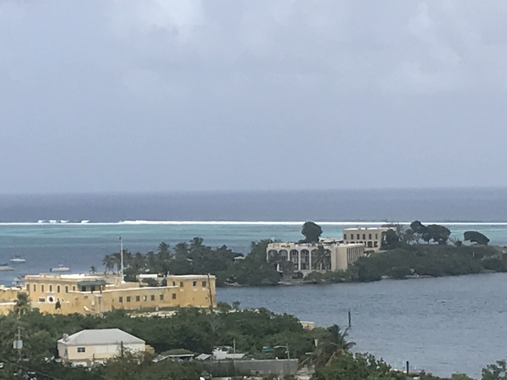 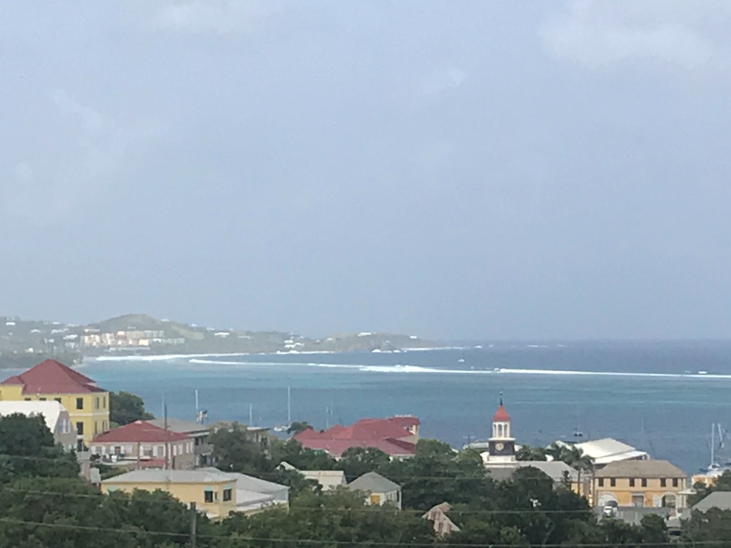   |
| - Oct. 8 - Don’t Think it’s Over |
|
|
Today I read a report on the Weather Underground by Chris Dolce: “ THE ATLANTIC IS QUIET RIGHT NOW, BUT THAT DOESN’T MEAN HURRICANE SEASON IS OVER “. It’s very interesting and should be read. As we all know, we cannot let our guard down until the hurricane season is officially over and we’re only watching snowstorms on TV. “In the last five years the final Atlantic storm of the season has ranged from as early as the last week in October to as late as the week of Thanksgiving. The name of that storm was OTTO. It formed in the Southwest Caribbean and made landfall in Nicaragua..” Chris Dolce is basically warning those who are convinced that we have seen the end of this season just because it’s quiet. In the report he gives us enough reasons why we should remain prepared. Read it if you will. Saharan dust showed up again, good and bad, it could mean that there are a lot of sand kicking ; storms which will eventually come our way. It has been very hazy, but a fresh breeze makes it feel very pleasant. We hope it remains quiet. Be well, be happy, and may God bless us all. Isabel  Rio is a good doggie. He wants to say hi to his friends in Indiana. |
| - Oct. 7 - Some Days Are Just too Beautiful for Words |
|
|
So, before I post the End of Day Special Photos, a reminder that we should keep those affected by Superstorm HAGIBIS in the Western Pacific in our thoughts and prayers. I believe that if LORENZO had not turned out to sea, it would’ve become a superstorm. We’re not out of the woods as yet and there are some interesting waves rolling off the coast of Africa. Currently, there is a system in the Atlantic above us that has a 50% chance to form. An orange X is marking that one and it is being investigated by the NHC. Two yellow Xs are over South Florida and along the southeast coast. Looks like they could eventually merge. Let’s be grateful that it’s not us, and pray that we can be spared any such horror. May God bless all. Isabel End of Day Photos |
| - Oct. 6 - Day 128 - Twelve Name Storms, so far... |
|
|
Good night, All ! I hope everyone had a wonderful Sunday. We did very well and got some much needed rest. I’m noticing a wave approaching, another one, this past weekend we were not affected on our spot on the hill will any rain. As a matter of fact, I can probably tell you more about severe weather on the mainland and the early projected snow for October than I can tell you about our weather, which has been absolutely beautiful. Visitors here must be having a great time. I know some that are sad to leave, but it’s time. Above us there is a system marked with that “X” and is being watched by the NHC for any development. For us, there’s no rain in sight for the entire week. However, that wave in the tropical Atlantic can change that pattern depending on how fast it’s moving, and if it gets here at all. So, let’s continue enjoying the fine weather we have while we have it. Be well, and may God bless us all. Isabel |
| - Oct. 5 ... End of turtle Watch Day Photo, see previous post. |
|
|
Sorry, the post was sent before these could be added .... Isabel |
| - October 5 ... Turtle Watch Day |
|
|
This watch which was postponed so many times, finally took place today. Two of the turtles refused to come out and being difficult to reach, they missed their opportunity to shine. The other four got their share of attention. The littlest one took off when he realized he was out of the compound. If it had been a race he would´ve been the winner. Our friends really enjoyed it, except for one of the girls, who is afraid of animals in general. Dark clouds loomed overhead and rained further away. That was good. There was even a rumble of thunder. The Turtle Watch was a success weatherwise and otherwise. We continue to keep an eye on those waves coming off the coast of Africa. A red blob in the middle of the Atlantic does not seem to bother the NHC. It cannot be a source of concern of concern. There´s a Low on the continent which bears watching. We have been most fortunate a have this quiet spell. Hope and pray it continues.Be well, be happy, and may God bless us and may God bless us all. Isabel |
| - Oct. 4. ... No Cyclone Activity for the next 48 hours.. |
|
|
It´s usually, ¨for the next 5 days¨¨. Is NOAA expecting Cyclone Activity after that? Let´s hope not. With the approaching tropical wave we should be having scattered showers over the weekend. There´s a system above us that´s being ¨watched¨. Perhaps that´s the one that will become something later on. Other than that there are several waves , like a train, that I´m sure are being monitored by the NHC and NOAA. I heard something today on the radio that makes me think the government is more concerned about earthquakes. I guess there has been enough quaking around here to warrant that. At the moment, all is quiet on the home front. May God bless us all. Isabel |
| - Oct. 3 ··· Winter Preparedness replacing the Tropics |
|
|
While the folks on the mainland are preparing for Winter, we´re not done with the hurricane season as yet. Not much is happening at the moment. NOAA had up to 17 storms in their increase for the hurricane season and they may well come. There are so many waves on the African Continent heading west, you never know. So, we´ll keep monitoring the Atlantic, and stay prepared. Both Dave and Gert will be sure to keep us informed. Be well, be happy, and may God bless us all. Isabel The Egg Fruit has seeds after all. It is a Canistel! |
| - Oct. 2 ·· It´s Not Over........ |
|
|
Until it´s over ! We must remain in hurricane mode at least until the season is over. In the meanwhile, we can enjoy sun and surf and the all the wonderful things life on our islands have to offer. Let´s not be shocked if all of a sudden an innocent, little wave that has been traversing the tropical Atlantic for a week and more, unnoticed by most, suddenly becomes a threat. It has happened. Currently, there´s an approaching wave, that is bound to ruin the final chance of a turtle watch with the Red Footed Tortoises on Saturday morning and our friends from Indiana. There´s a good percentage of rain in the forecast for both Saturday and Sunday. There are a series of waves getting ready to step out of Africa just on time for the second peak of the hurricane season. Be on guard... I want to thank all of the fine people out there who are responding to my various queries. It´s so interesting to read and learn from the information I´ve received. My friend Jane in St. Thomas, also a correspondent, loves to do flora research. I learned today from someone in Florida that the ¨spaghetti ¨ weed that´s an absolute pest is referred to as Devil Weed or Love Weed. In my book it will henceforth be Devil Weed. The Egg Fruit, I found out from another, that it could be from a Canistel. However, this fruit is like pudding all the way through. I gut a piece for my smoothie this morning and it´s delicious. I´m posting a picture of it to see how it looks on the inside. It does not have seeds like the Canistel. The egg friuit really looks like egg yoke on the inside. Be well. May God bless us all. Isabel    |
| - Oct. 1 Hot and Humid |
|
|
It felt as if something comin´.. Hard to believe it´s October already! We´re not out of the woods yet though. As Dave reminded us, there have been some big storms in October. We need to remain as vigilant as ever. November can be as bad and as my aged father said many years ago, there has even been a hurricane in December. My father was jobless and single when the 1928 hurricane hit and St. Croix was flattened. He came with others from Vieques to help with the cleanup. He met my mother here. How romantic, and that in the midst of chaos! The San Felipe hurricane, also known as ¨Okeechobee¨ was one of the deadliest in the recorded history of the North Atlantic Basin. Sept 6, 1928 to Sept. 20. It was the only major hurricane of that season with winds of up to 160 mph! HUGO was a carbon copy of the San Felipe hurricane. It took 60 years for him to make his appearance. The very name still instills fear in those who experienced it.We´re thankful that LORENZO did not come this way. We must remain vigilant for sure. Be safe, prepared, and may God bless us all. Isabel _
|
| - Sept. 30 - End of this Infamous Month |
|
|
Some of the most horrific hurricanes have been in September. Things have changed, however, and they can happen at any time, as we noticed this season. There are still another two months to go with November having surprised us in ‘99 with Cat 4 Hurricane LENNY moving from west to east right into our backyard; the EYE just 45 miles to our south. That was rough! Especially when you have to battle it all by yourself. LENNY was a very unusual hurricane. They called it “wrong way LENNY”. At the moment there’s a suspect in the western Caribbean, but it’s moving as they usually do, away from us, not towards us. The other suspect “X”ed is on the Atlantic side is above the Dominican Republic. That one could be going after Hurricane LORENZO, which is on it’s way to the UK..Hope they’re ready. I was with our family in Germany one summer, when the kids were little, when one of these systems went through the UK, and through Germany causing tremendous flooding when the dike was breached. Mercedez Bentzs’ floated away. We have to remain in hurricane mode with the second peak around the corner. The tropical wave in the Atlantic seems larger today than yesterday. That might become a suspect soon. Our next rain is for Friday night. I think that’s when that wave will reach us. Be safe, be happy, be prepared. May God bless us all. Isabel We were happy to learn that our dear friends in Santiago, Chile are fine after the 6. 7 strong earthquake in Constitucion and Santiago struck yesterday.    |
| - Sept. 29 - Day 121 - Hurricane LORENZO category 5 ! |
|
|
Are we ever thankful that that LORENZ Monster is moving away from us! Hopefully it will dissipate before it reaches any land. It would be devastating for them. As for us now, there is a relatively harmless wave crossing the tropical Atlantic, but some rather big ones are crossing the African continent. One is getting ready to step off, but so far it hasn’t been marked as anything to watch. “X” usually marks the wave in question. If you read my post yesterday, a hurricane preceded the terrible earthquake of 1867. As if one disaster is not enough, two can happen in a short space of time. Are we really ready for any kind disaster? Our weather has been very pleasant since Tropical Storm KAREN passed us. We have been getting just quick showers, the sun shines, visitors are able to enjoy their days without much disruption in the weather. Unless something pops up out of nowhere, this would be a good time to visit. The next wave, not yet a potential storm and may never be one, is still more than a week away. If you are really interested in visiting at this time, just check the weather sources and see how it looks around the time you wish to visit. For the rest of us locally, we have to do the same and keep in mind that we’re heading towards the second peak of the hurricane season and we have to make sure that everything is done that should be done. Be well, be safe, and may God bless us all. Isabel |
| - Sept. 28 - Hurricane SAN NARCISO and the Terrible Earthquake and Tsunami of 1867 |
|
|
“Greetings from your weather lady” is how I began the meassage to my Pastor concerning a developing, potential storm for us. He knew right what that greeting meant. It was not good news. It meant a storm was coming. However, I told him that it simply had to be monitored even if in the end it did not come near us. Well, now in the same way, I would like to draw your attention to another situation, by posing this question. Can hurricanes influence earthquakes.? The one in 1867 seemed to be the case. It happened on Nov. 18, —“20 days after experiencing the deadly SAN NARCISO hurricane..” If you are interested in the details of how our islands were affected go to The St. Croix Source, U S Virgin Islands —read all about it. THE TERRIBLE EARTHQUAKE AND TSUNAMI OF THE DANISH WEST INDIES ( that was us ) AND THE BRITISH VIRGIN ISLANDS. I would like to add that at 2:50 p.m. that day, “The seafloor fault ruptured and released energy at least the equivalent of more than a thousand times the explosion of the Nagasaki *nuclear bomb. Today it is estimated of having been between 7.2 and 7.5 on the Richter Scale”. *nuclear (or atomic-bomb) This all came to mind because of the uptick of earthquakes especially here in our neighborhood. Just recently as Puerto Rico was being threatened by Tropical Storm KAREN, the northern section experienced some earthquakes the strongest of which was a 6.0. I did not feel it but others here on St. Croix did, and it was frightening. Can it be that after 152 years the Anegada fault is getting ready to rupture again? We were warned in the recent past that we are overdue for one. That is why we have to be all the more ready for such a devastating event. That can happen suddenly, not like a storm that takes some time to get here. Are we ready? Read the article above from The St. Croix Source and find out how the survivors coped with one disaster after another. Let’s watch and pray. Be ready. Be safe, and may God bless us all. Isabel |
| - Sept. 27 - Hazardous Weather Outlook |
|
|
This was issued late this afternoon. Besides the risk of rip currents, there is a high heat index between 102-107 degrees across portions of St. Croix. “Everyone should take steps to prevent heat-related illnesses.... I must admit it was a very hot day, but the evening is quite pleasant. Saturday though Thursday : A tropical wave will push into the region this weekend enhancing shower and thunderstorm activity across the local islands Saturday into Sunday...1 to 2 inches of rainfall is forecast for St. Croix. Well, I haven’t noticed anything out there, so I’m curious as to where it could be coming from. We shall see if it comes to pass. We should be seeing the effects of LORENZO in the form of choppy seas and rip currents. Let’s enjoy the quiet while we have it. Would be nice if the season ends early. Watch and pray! Good thing there was no active system out there today to hold our attention. We spent a good part of the day fussing over a Frigidaire Washer, kept getting error signals. The hot water hose idoes not connect properly into the washer and so on. We. Have to call for help tomorrow. Anyone out there with a similar washer? Some useful tips could come in handy. May God bless us all. Isabel Busy, hot day! Goodbye, Sun |
| - Sept. 26 - A Quiet Spell |
|
|
Is it possible? Can it be? No other potential storms in sight at least not for the next five days. When we look at the massive size of Hurricane LORENZO, it’s frightening to think that we have had such monsters over our small islands. I hope it does not reach Europe, some of them do. I also hope and pray that we don’t have the likes anytime during the rest of this season. There are many waves coming off the coast of West Africa, but thankfully the Saharan dust is back to some extent and can hinder the formation of these systems. I noticed two unusual things about KAREN. In the past, the tropical systems which crossed the Windward islands into the Caribbean Sea. Would continue straight across. KAREN turned to the right and came up in our direction; the other thing I noticed is that it was being hindered from getting organized. We easily could have had a major hurricane considering how much warmer the Caribbean Sea is to the Atlantic. I should have mentioned earlier that KAREN also skipped a stage, it went from a strong tropical wave to a tropical storm, it was not a Depression. Later on it became a Depression and as it approached land it became a tropical storm again and still is. We did not get the amount of rain we thought we would get, but I think at least 1-3 inches. If anyone has this information please share it. I have two garden carts out there which have at least 3 inches. We don’t allow standing water to prevent the mosquitoes from breeding, We fill bottles for later use for the turtles and plants when it does not rain for a spell. The bananas need water, the more the better. While on the subject of fruit. I went Sugar Apple picking this afternoon and did not notice the bee hive. I got stung on my right thigh, on my left arm, and on the back of my left leg. I tend to swell. Tonight I plan to take Benadryl, an antihistamine, to try to keep it down. I cannot take it earlier as I still have several things to do and it will make me drowsy. Give me any tips that could help, please. I managed to get 4 Sugar Apples, but there are many more. My husband will spray the hive tomorrow. He has had to do that in other places. Be well, be happy, be safe, and may God bless us all. Isabel |
| - Sept. 25 - T. S. KAREN is gone! What’s Next? |
|
|
Thank God that Hurricane LORENZO is heading out to sea.!! What a huge storm! I was checking West Africa where these waves begin and and can even develop while still over land, like LORENZO. We hope we don’t have one of those, however, there are many waves lined up. It’s only a matter ofTime and we will have to face something. Puerto Rico got a double whammy with some earthquakes in addition to T.S KAREN. The strongest a 6.0 was felt hear by some. When I see a crooked picture or two on a wall, I know the ground was shaking. In addition, one of our cisterns is leaking water on the garage floor. That cistern was cleaned, treated for cracks, painted, etc. not too long ago, and now this leak; it can only be from those earthquakes. We’ll have the guys come back to check it. Let’s watch and pray, the season is not over. May God bless us all. Isabel |
| - Karen |
|
|
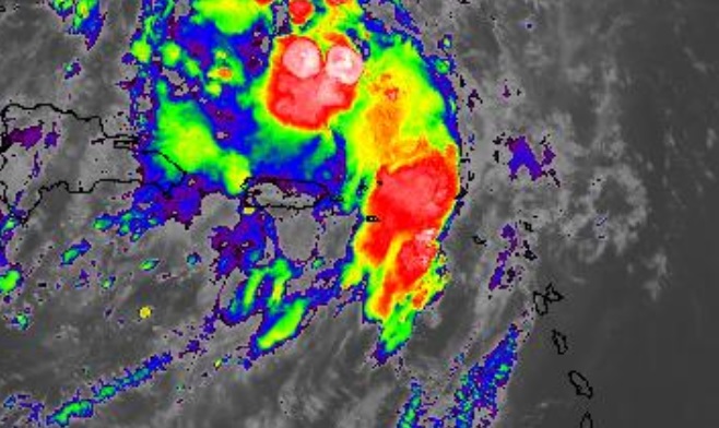
The last I posted, I was expecting more rain but before I turned in just before 10 pm last night our parking lot was dried already. I doubt we had much rain last night, it didn't look like it at 6 am. Right now the satellite shows rain dumping on us and NADA is actually happening. The sky is brighter and not a lot of clouds. The sky is a tad bit darker to the east which is the way the satellite shows it expanding but it's not raining at all and it's 7 am now.
|
| - Sept. 24 - Very Strong Gusts of Wind this Evening |
|
|
According to Gov. Bryan, our governor, late this afternoon, public schools are closed for tomorrow as well because heavy rain is expected. I must say TS KAREN is taking her “sweet time”. She should have been out in the Atlantic by now. Well, she is still going to deliver some impacts mostly by rain and flooding in PR and the USVI as she closes in on PR tomorrow. My daughter, who teaches at a private school, has to wait until the morning when the faculty will be notified. We thought that the worst had passed, but they’re even talking about possibly having to open shelters tomorrow because of the impending weather and the fact that storms are prone to shift and intensify. In other words, the government is ready “at a moment’s notice” in case of an adverse change. So, all we can do at this stage is hope that tomorrow morning there will be a change for the better, and everyone can go back to their normal schedules. Be safe. May God bless us all. Isabel End of day photo. Heavy rain, in one section, across from us.
|
| - Karen |
|
|
Just overcast. Clouds not moving much. And rain off and on. No more gusts. Rain is not heavy. It looks to be over.
|
| - Fwd: Valeria Rogers shared 1 video with you | ||||||||||||||
| ||||||||||||||
|
---------- Forwarded message --------- From: Valeria Rogers (via Google Photos) <noreply-9adf3d7e9a758941ee8d94155c9118a3 at google.com> Date: Tue, Sep 24, 2019 at 12:33 PM Subject: Valeria Rogers shared 1 video with you To: <riarogers52 at gmail.com>
| ||||||||||||||
| - Karen |
|
|
It's blustery and rainy now. And it's about the time stormcaribe tracker said it would be closest.
The top of the water has completely changed. I've attached a video of it really pushing offshore so it's coming up the the back or south now as Karen approaches. The water was coming in and the sudden switch caused some swirlies for a moment. Was watching for a couple of water spouts. Video will follow. |
| - Sept. 24 - (11:25 a.m.) - TS KAREN is Arriving! |
|
|
We had a break this morning, so I went out and even had to wear sunglasses. But we were “warned” that the bulk of the storm was on the way. Our grandson called from Spain (via WhatsApp ) to say that we were going to have lots of rain as of 1 p.m. KAREN has been crawling along, now at 8 mph. It is looking and feeling stormier and this is probably the prelude to the major rainfall in the forecast. Some zones on St. Croix are flood prone, so I’m sure they are in for major problems. Puerto Rico has many rivers, and high mountains, so they are in for even greater problems. I hope everyone affected by this system will use the proper precautions to get about, if they really need to go anywhere. The best thing is to stay put when there’s severe, hazardous weather. It’s not worth losing one’s life to go out for the newspaper. Be safe! May God bless us all. Isabel |
| - Fwd: Karen |
|
|
From: Valeria Rogers Date: Tue, Sep 24, 2019 at 4:30 AM Subject: Karen Hi. Just checking in from St. Croix, East side. We had a deluge of rain, not wind at 5 am. Radio news just said eye would be passing by St. Croix at 8 this am. Doesn't coincide with stormcarib's estimate of afternoon. It does look like we're going to get another wave of rain soon coming in from the east. The water looks like it's rippling from the NW though. We'll see. Just rain for now.
|
| - Closest Point of Approach |
|
|
Here we are! Time for me to retire for the day and it’s still high and dry. However, according to the CPA, in 2 hours and 28 mins, KAREN should be in our location. It has moved farther away to Puerto Rico since I last checked. I noticed that KAREN does not seem as disorganized as she did on her trek. PR is definitely going to be bombarded with heavy rain. I just hope it does not stall. I hope everyone there is being very cautious. How much rain we are going to get may not be a whole lot, but for people dependent solely on cisterns for water, every bit helps. May God bless us all. Isabel |
| - Sept. 23 - TS. KAREN is Now a DEPRESSION |
|
|
We have been getting bits and squirts on and off all day, but not the rainfall we thought would start at 2 pm. Public schools were dismissed at noon, supermarket workers, at least some were going to be dismissed at 4 pm; I’m sure all government workers were dismissed early; even WAPA closed shop at 11 a.m. My husband tried to pay a bill online and was told it was not possible then as they were doing “maintenance”. Everyone was hurrying and scurrying. One thing I must say, these storms keep us on our toes. For all we know, this could have been a drill for bigger things to come. Tropical Storm KAREN was downgraded to a DEPRESSION, probably at the 5 pm update. I took some sunny photos at 5 and when I went to feed the turtles I had to be fast, dark clouds were looming, and soon it broke, but not for long, that was just a lengthier squirt. I came back in like a wet chicken, but I think I can still go outside again; it’s fine once more. I will post again later if we don’t have a power outage, otherwise, I’ll write and have the post go out whenever it can. So be safe out there. I heard from my weather friend in Arizona that they’re even having rescues due to flooding from the remnants of TS LORENA. Keep in mind that those were remnants and a DEPRESSION is the prelude to a Tropical Storm It packs a lot of rain. We were alerted that we can still expect heavy rainfall and gusty winds. Just got a Flash Flood alert until 5 am. Until later. God bless us all. Isabel |
| - Sept. 22 - TS KAREN and Thirteen, or is it Twelve...? |
|
|
Good night all! Here we are preparing for the assault of TS KAREN. Hope it will not be too bad. I have checked the CPA three times and it continues to give the same, that the storm will pass us by a bit over 100 miles. I don’t trust the storms to stay on their track. My fear is of fear itself, but in reality, what about Rapid Intensification. So far, it shows no sign of that. According to Dave’s report it will stalll after it passes us. It can even become a CAT 1 storm. Tomorrow, Monday evening, the rain should begin. TS KAREN is expected to pass at its closet point to us (102.3 miles way) approximately by 7:06 a.m. on Tuesday morning with heavy rain and gusty winds. The rain shall continue through Wednesday, that is, according to the forecast. We are as ready as we can be. We are also watching TS Lorena, at least the remnants which can still be devastating on very dry land. Finally some rain! May everyone be safe, here as well, taking all the precautions necessary. Be well, be ready, and may God bless us all. Isabel P.S. Unfortunately we could not have the turtle watch, but we haven’t lost hope neither have the turtles. |
| - Sept. 21- Day 113 - Be Prepared for 99L !! |
|
|
Attention everyone in the eastern Caribbean. 99L is going to head this way. It has the potential to become the next name storm. The track takes it right through St. Croix, however, check the Closest Point of Approach on Stormcarib to see for yourselves and make the necessary arrangements. Be attentive because watches and warnings are going to be posted on Sunday. Without much ado, I shall share the following information with you. Be well, be safe, and may God bless us all. Isabel |
| - Sept. 20 - Is 97L a Phantom ? |
|
|
We are no longer concerned about Hurricane JERRY. The forecast for us is cloudy/partly cloudy for the weekend. That’s good for us and our tortoise watch. Unfortunately, we had a delivery of a washer to replace our old worn out one and all went well until the guys left. The van tore into the tortoise domain, breaking down part of the wall. The driver never even stopped to apologize. The problem now is to keep the tortoises inside. Already this afternoon one of them was strolling outside even though we tried to secure it as best as possible. I hope that we can still have the “watch” tomorrow afternoon. The weather should be fine. Our big rain will come with 97L on Monday through Thursday. It has a 40% of developing, but it is not listed. The one that is listed along with JERRY is 99L. It is only coming off the coast tomorrow, but it already has a 70% chance of developing into a cyclone. The good news is that the most reliable models veer it out to sea. Let’s hope this is not a tricky one. Be well, be ready. God bless us all. Isabel |
| - Sept. 19 - Hurricane JERRY is Around the Bend! |
|
|
We’re keeping a close eye on JERRY. He’s above our latitude now and is expected to pass on Saturday midnight by 242.9 miles from our location according to the Closest Point of Approach this evening. That’s a comfortable distance. We still hope to get some rain out of it, especially my niece next door. They just cleaned their cisterns and had them ready, but finally had to order water since JERRY did not look promising in that way. However, I notice that JERRY has quite a wide circulation that could possible spin some rain in this direction. I read somewhere that we can get up to 3 inches of rain this weekend. I still remember FLOYD and JOSE. They trailed flooding rain for days and up to a week. FLOYD was far to the west and it was still dumping rain, and JOSE was over 500 miles up near Bermuda and it was flooding us here. We could see the distinct trail from us to the center of the storm. Perhaps JERRY will do the same, for the sake of those who need water for their cisterns. That could be us too pretty soon. There’s a downside to a rainy Saturday, if it does. We are finally going to attempt the “Red-footed Tortoise Watch”, which we have had to postpone in the past. We are finally getting together for the event, but concerned that it might be rained out. I’m hoping that if it rains it does so after the event. There are two other systems that will be coming along, especially a very vigorous one coming off the coast on the weekend with the determination to make headlines. The following weekend looks like a washout also. This season though it may look busy would have to surpass the one where all the names were used, or another season when we had 19 name storms. So far, JERRY is only the 10th storm. In other words, we have a long way to go. I pity the plight of the Texans along the Gulf. Coast. Just imagine over 40 inches of rain!! Be well, be prepared, and may God bless us all, Isabel |
| - Sept. 18 - Tropical Storm JERRY |
|
|
Suspense is growing with T.S. JERRY in the wings. Is he coming closer than what the closest point of approach yesterday suggested? According to todays newspaper, it will pass by 100 miles, which brings it more than a hundred miles closer than the CPA I did yesterday. We are urged to be very vigilant because it can move even closer. According to Daniel Brown, an NHC forecaster, “ There are one or two credible models that have a track over the USVI and Puerto Rico, thus, everyone across the region should monitor the storm as we get closer and forecast models more closely agree on a solution.” Things can change rapidly as we already know from DORIAN. It was noticed at 5 p.m yesterday that it had wobbled a bit more west. That’s why we need to be vigilant. Let’s not be complacent that it is definitely going to pass to the north. Prepare as if it’s coming overhead.! On this 30th anniversary of HUGO, which began yesterday, I promised to share a very interesting piece of information on how the massive debris from Hurricane HUGO was managed. From the newspaper at that time, i gathered the following for my report: “On Nov. 5-6, 1989, over 200 million tons of it, 25 feet high, about the size of ten football fields, was scheduled to be burned. A controlled burn of this sort with that amount of debris would take 24-36 hours, otherwise, according to the authorities as stated in the St. Croix AVIS, “ It would would take about 4,000 days for the island’s two incinerators working around the clock to burn the debris.” Another option was of “shipping it to fuel-starved Haiti. But a government expert estimated that 10 barges would have to take daily excursions for more than four years to haul the trash to Haiti..” And if we think that that was all the debris, let us look again. The 200 million tons “represented only 20% of the storm-related trash that must be burned. Based on that percentage, the amount of HUGO debris on St. Croix totals an estimated 1.8 billion pounds. Although burning the debris was a good solution it became a serious health hazard. All was fine as long as the wind blew it away from populated, but eventually everyone was affected by the smoke, and so, the problem remained a problem. Keeping in mind that this is a small island (82 sq ft), how does one dispose of so much debris? With this amount of trash we are sure to run into it no matter where we turn, right? Wrong! It was all being transferred to specific areas out of the two towns, out of sight, but not out of mind. This excerpt was taken from my report on HUGO after my visit a month after the horrifying hurricane. Be well. May God bless us all. Isabel |
| - Sept. 17 - Tropical Depression # 10 |
|
|
Incredible amount of activity! Right behind, soon to be Jerry is another wave. The question is that NOAA mentioned one coming off the coast on Thursday, but no mention of the one behind “Jerry”. This current Depression should become a Tropical Storm tonight, according to the latest from Dave. I checked the CPA and it should pass us at 4:00 a.m. on Saturday morning some 200 miles to the north. BUT, is it going to STAY on that path? Or is it going to wobble! Regardless, we can expect gusty winds and rain, how much is to be seen. Today is the 30th anniversary of HUGO - the master destroyer of our island in 1989 and the master builder for future generations. A lot was learned about construction! In the past, houses were built rather loosely, partly dishonestly, partly to save on expenses, especially since there was no major impact on St.Croix since 1928. When HUGO impacted us, houses were flying along with entire trees and all the debris imaginable. The hurricane lasted well into the 18th so tomorrow I shall give a description of the massive debris and how it was managed. Be well, be prepared, and may God Bless us all. Isabel End of photo day. (I had to write a good part without a cursor, not easy) |
| - Sept. 16 - Keeping an Eye on 97 L |
|
|
Ever since DORIAN we cannot be complacent into thinking that a storm will go a definite route. For instance, 97L is is going to pass to our north, may not be the case. Some models has it pointing straight at Puerto Rico, that’s quite close to us. Crown Weather has issued a heads up for our islands. We have to keep an eye on this system until it has passed our area. It still has a way to go before it does that. Anything can change. So let’s be alert. We had a good dousing of rain most of the morning, and again tonight. The wave that brought it was mostly to the south of us. We have rain in the forecast for most of the week; sounds discouraging for anyone planning a trip. It very seldom rains continuously unless we have a full blown storm that trails rain for days after. So my recommendation for anyone wanting to visit now, is to monitor the Atlantic, check the weather sources for information and make your decision. For the ;peals, we know the routine. Preparedness is the key word during this season.Be well. May God bless us all. Isabel Rain is whipping the coast at Judith’s Fancy. |
| - Sept. 15 - Day 107 A Fish Storm...? |
|
|
Good night, folks, near and far. I was so happy to read on Dave’s blog that 97L, out in the Atlantic, is forecast to become a “fish storm”. It can still become a Depression and maybe even more, but nowhere near any land. It’s just going to annoy the fish in the vast Atlantic. The fish know how to protect themselves. Our weather turned out to be a prize winner, but the Power Authority gets a low grade for leaving us without electricity for four and a half hours this morning. This has become a major problem That’s why I have to turn on the circuit breaker for my wall oven when I need it and turn it off when it’s done. Power outages play havoc with the electronic boards of the oven. Very costly to repair. Rain is in the forecast from Monday to Thursday. Probablyly not steady rain. At the moment our lawn, etc. are so overgrown that we need some dry time to get it trimmed. We’re hoping to finally have our turtle watch on the 21st if it’s not raining. While Dave gladdened our hearts somewhat, he made it clear at the same time that another wave splashed down into the Atlantic and others are in line to do the same. NOAA predicted 10 -17 name storms when they increased the activity level. So far there have only been eight. Be well, be good, do your hurricane homework, check the list, above all pray, and may God bless us all. Isabel |
| - Sept. 14 - A Sigh of Relief |
|
|
At one point I counted five systems, including T.S. HUMBERTO, plus a sixth one coming off the coast of Africa. I’ve never seen the likes before. Woe to us on these small islands if we should have a repetition of 2017. Now this evening, we can breathe easier. The one remaining system, to our east, is showing signs of curving out to sea. We know it’s not over until it’s over, but for now, there’s nothing of major, or immediate concern. Our Sunday looked as if it would be a wash out with the heavy rain in the forecast, but now there’s only a slight chance of rain, which is great for our pot luck celebration of our parish. The next rain is forecast for Monday. We may still get some quick passing showers like the one this afternoon. Whatever the case, it certainly is far better than the ominous scenario earlier. Be well, be prepared, and may God bless us all. Isabel |
| - Sept. 13 - Tropical Storm HUMBERTO |
|
|
T.S. HUMBERTO formed today over the same battered area of the Bahamas. One can only imagine how it must be for victims and responders alike. This storm has behaved almost as erratically as DORIAN. It was stationary for a time. That is the worst thing that can happen. Such a scenario of heavy rain, gusty winds, and pounding surf all around can only augment the fear and pain of those who are already fearlful and suffering in varied ways. The near future, unfortunately, does not look too promising when we have three other systems in the tropical Atlantic trying to decide whether to move on individually or merge into one mega storm. They all seem to be pointing this way. Dave thinks that one of them will be a “fish storm”. The others really don’t have much to keep them back. Looking further to the east there is yet another tropical wave coming off the coast of Africa. NOAA was right when they increased the storms this year. It seemed like a mistake at first, with such a lack of activity. People were beginning to question the validity of a such a decision. Now, here we are facing the challlenges of multiple storms, which somehow like DORIAN’S track, in our direction. Today VITEMA sent out an alert for heavy rain on Sunday, Monday, and Tuesday. This type of rain causes flash flooding. Hardly will one system be gone when something else is arriving by the end of next week. We just have to hope and pray that none develop like DORIAN, nor become stationary over any land. We must monitor these systems and be prepared in case of a direct hit. Get that bottled water, the heat has been intense, get your non-perishable supplies. Be ready, and may God bless us all. Isabel |
| - Sept. 12 - |
|
|
It’s looking more and more as if we shall have tropical trouble next week. This is what Brian Donegan of WU wrote in today’s report. “Eastern Atlantic Disturbance May Become a Tropical Depression or Storm next week.” Acccording to NOAA’s graphics St. Croix is within the cone of uncertainty. “Conditions are expected to become more conducive for development in a couple of days..” He also added.”..those odds can increase or decrease in the days ahead as atmospheric conditions evolve along the systems’s path.” Rain is in the forecast for the next 4 days courtesy of 94L, which pretty much disintegrated and is just a regular tropical wave. I am looking forward to a cool down. It has been quite hot these past few days. Our neighbors on the island chain and us should pay attention to the next disturbance. In the meanwhile, the 9th Depression has formed in 95L heading for Florida. It might just swipe them as it moves along the coast; similar track as DORIAN. Stay safe everyone, be well, be prepared, and may God bless us all. Isabel |
| - Sept. 11 - High Heat Alert! |
|
|
This was the day that my favorite buildings came down taking so may lives with them. It happened 18 years ago on the clearest, bluest sky days in a while. We saw them from our 29th floor during those good old times in Manhattan; we took our visitors to see them and always went up to the very top. I liked to stand at the bottom on the plaza and look straight up to the top. Those buildings were amazing! It took seven years to build them, if I remember the info correctly, and it took two hours for them to collapse. I was so sad for their loss, sadder still for the many people who died with them. We were already living in St. Croix and saw it like millions, on TV. The weather was so beautiful that morning that some people took the day off. How can we ever forget that terrible day? Today we had an unusual alert. I guess the combination of humidity and heat set off the alert alarm. I did not find it any hotter than yesterday, which felt really hot. Things are heating up. The system 95L which I thought was the one off the coast of Africa, is the one heading towards Florida and the Gulf, unfortunately it has to pass over the Bahamas, dumping lots of rain on roofless, defenseless people. NOAA is giving this disturbance a 70% chance of formation in 5 days. It is expected to become the next name storm. Now, the one which came off the coast of Africa is orange. That means it has a 40 - 50% chance of formation in 5 days. I heard that it is Invest 96 L, but haven’t seen it anywhere as such. There doesn’t seem to be much in it’s path to keep it from developing into a cyclone. We have to watch this one for sure. It’s heading west but often curve up towards us. Let’s watch and pray! May God bless us all. Isabel  |
| - Sept. 10 - Day 102 - The Peak of the Hurricane Season |
|
|
We are at the top, the peak. From here on things can really go downhill, and I mean downhill. Some of the biggest storms have come around the middle of September. The good news about 94L is that it’s falling apart due to wind shear; it’s remnants, I understand, are going to be taken over by the one behind it which I assume is 95L. It has not been officially listed as an Invest as yet. That one should be in our area by Friday of next week, in whatever form. The next name on the list is Humberto. It has not revealed itself as yet, but it can very well be 95L . This is the time to be most vigilant. We should not let our guard down. We’re having some very nice days, rather hot, as we say, “hurricane weather”, because the ingredients are present. Scientists say that hurricanes need a depth of 200 ft of warm sea water to rev up the huge monster cyclones. I believe that it is that warm to have generated such a hurricane as DORIAN. We have yet a little more than half of the hurricane season to go. Are we prepared for what could come.? Today I was speaking with an acquaintance about DORIAN and the catastrophic destruction in the Bahamas. She is prepared yes, prepared to leave if such a monster is headed this way. Not too long after I met a friend who was shopping for her trip to Nassau where she has a brother. She was going to a wedding. In the midst of such terrible sadness, and she felt it, life must go on in the land of the living. May God bless us all. Isabel |
| - Sept. 9 - Lots of Activity out There |
|
|
The big potential menace that threatened to be the next hurricane has shriveled to a 30% chance of development. It is still to our south when it finally passes, however, the tropical wave that just came off the coast of Africa is looking to swallow 94L . At the moment, it’s getting it’s act together. As it treks across the tropical Atlantic we shall see when, where, and how it’s going to move. The Weather Channel folks seem to think that it will develop and come more in our direction. Is it ..?? Well, we know the rules, plan ahead and be ready. It’s quite possible we can have something to deal with in the near future. Today was a bright, shiny, beautiful day and tomorrow should be the same. Nice for everyone, especially for visitors, who pay to come here. However, according to the forecast for the week, it should be raining from Wednesday to Friday. As we know already, that is not always the case. As long as we’re within the hurricane season, we can expect turbulent weather every now and then. Be well, be prepared, and let’s think of the folks in the Bahamas and how we can help the survivors. I read today that the dead can be in the thousands! May they rest now in peace. Our diocese which consists of three islands is having a special collection this weekend. May God bless the Bahamians and us all. Isabel |
| - Sept. 8 - Day 100 - Watching Invest 94 L |
|
|
Good Sunday night to all. Hope it was a happy day, or at the very least, a good one. To those of you tracking invest 94L, I want to share what NOAA is saying as of my last check a few minutes ago. “Some slow development of this system is possible during the next few days while the low moves west-southwestward-to westward across the central tropical Atlantic Ocean. The key word here for us is westward. In other words, after moving southwestward it’s going to move west again. The good news is that “By Thursday. The upper-level winds are forecast to become less favorable for tropical cyclone formation.” It could easily be permanently disrupted, ripped apart. However, some of these systems are hardy and determined forces. They will get through anything; that’s what DORIAN did. So, we watch and pray and hope for the best. May God bless us all. Isabel |
| - Sept. 7 - The Bottom Line is This |
|
|
Some headlines really freak us out! With reason! After what we have been through in the past, especially with hurricanes IRMA and MARIA, we jump when something is looking to threaten us. That’s a good thing in a way, but it can cause a lot of undue stress especially if all the facts are not there as yet. Take for instance, the new Invest 94L way out there in the eastern Atlantic. It’s going to take “forever” to get to our neighborhood, but then again, it may never come this way. The last thing we should lose is hope; hope that it goes out to open sea and harm no one. Now the guy from Direct Weather irks me sometimes, like today. He said it seems to take a similar track to the Bahamas. Now, is that anything to say at this time when those poor folks are struggling with the shock of their new reality, that everything is gone, especially their loved ones? The bottom line is that as we are not weather experts, we should simply monitor the storms. Use the tools given us if we want to know. Some people couldn’t care less until the storm is on top of them. At the moment, i’m monitoring a sluggish 94L, half-stifled by Saharan dust, but holding it’s own. A bit farther on, conditions are better and it probably will seize the moment, hope not. It came off the coast of Africa as a vigorous wave; that being the case, then it’s similar to DORIAN, which could not be disrupted by anything. In the meanwhile, we continue to get abundant rain from passing rain clouds. Great for the cisterns, plants and fauna. Deer come down from the hills when there is an extended dry spell. They need those pools of water. Let’s keep an eye on 94L as we go on with our lives. Be well. May God bless us all. Isabel |
| - Sept. 6 - Out of Africa |
|
|
During this month our storms are coming mainly from Africa to our East. At the moment we are watching one which is still a baby as it moves westward across the tropical Atlantic. At this stage it only has a 10% chance of development. Perhaps that area is not as conducive for formation as the path ahead. As Dave said, DORIAN has moistened the path, prepared it so that any other system can get through without any hindrance from dust and apparently there is not enough of a wind shear problem as it gets closer to the islands. By that time, it will have a 70% chance and the sea is warmer, the fuel is ready. The H storm will be ready. Dear neighbors on the island chain, please monitor this system carefully and make sure to be as well prepared as possible. We have to do the same. By this time next week we will probably have a hurricane on our heads. This afternoon we had a torrential downpour! I must say that as a “weather lady” I was perplexed as to where it came from. There is a system passing close to our north, but the radar seem to be showing rain from the south. So, I just let it alone, and enjoyed the rain. We hadn’ seen such intense rain since DORIAN passed by as a Tropical Storm. I’m sure there’s more to come, after all, this is the rainy season. Be well, be ready, and may God bless us all. Isabel |
| - Sept. 5 - Potential Cyclone for the VI. ! |
|
|
The news we never want to hear at this time of year is that a tropical disturbance with potential to become a cyclone is coming in our direction. To be precise, this is what Steve Bullock wrote in the AVIS, our local paper, “SEVERAL OF THE RELIABLE GLOBAL FORECAST MODELS DEVELOP THIS SYSTEM AND TRACK NEAR OR OVER THE NORTHERN LEEWARDS ISLANDS AND THE VIRGIN ISLANDS IN ABOUT EIGHT DAYS ”. That would bring it to our doorsteps by the middle of next week, give or take a day or two. Is it following the same track as DORIAN ? Is it going to be as monstrous? And are we ready? To top it off, it will bear the H name. HUGO brought 15 tornadoes with it. They tend to leave clear, identifiable tracks. I’m assuming that the hurricane damage and total destruction of tornadoes differed. I saw it first hand when a month after HUGO I arrived in St. Croix about the Insurance for our rented Condo which was gutted. A friend of years give me a tour and I was able to see it all up close. This may not be as bad as HUGO, but then, it can be as bad as DORIAN. Let’s watch, pray, and prepare for the worse, while hoping for the best. Let us cooperate with Gert in assisting those who were left destitute in the Bahamas. See this site for information. May God bless them and us all. Isabel |
| - Sept. 4 - Day 96 The Peak of the Hurricane Season |
|
|
We are in it. Slowly climbing, and around the corner of the peak, are always some of the most vicious storms. That is perhaps, because during this month, the sea is at it’s warmest. That is fuel for the tropical waves that just require the right atmospheric ingredients to come together to create those monstrous storms. One cannot say this is happening now, because when we read the account of Alexander Hamilton in 1772 about his experience during a hurricane on St. Croix as a teen he could easily have been describing any of the same that we have experienced in recent memory. Between the San Felip Hurricane of 1928 and Hurricane Hugo of 1989 St. Croix had never been struck by a hurricane. They passed us by to the south and to the west. We got the fringes, some of the rain, a stiffer breeze. That is why St. Croix was so ill-prepared for HUGO. I suffered in New York as I saw that huge monster swallow my small island. My parents, siblings,and their families were there. It was torture. It took three weeks to find out if they were alive. I can imagine it must have been the same when the Bahama Islands were being eaten alive. How their relatives off island must have suffered. What a sad, sad, scenario. It was especially bad because it is so flat there, unlike St, Croix that has hills, mountains, and a landscape that floods in parts mostly by rain. We have never had the entire sea invade our land as it did in the Bahamas where you could not tell the land from the sea. It was all one in those areas targeted by Hurricane DORIAN. We are watching with intense concerned that next system that just came off the coast of Africa. It already has a 50% chance to develop. Unless it’s initial track changes, we can be seeing the next major storm in the near future. Where? That is too early to tell as they seem to have a mind of their own, but ever since our Master teacher, HUGO, houses are stronger, people rush to prepare whenever a storm is approaching, and take the precautions necessary. May God help us and bless us all throughout the rest of this season. Isabel |
| - Sept. 3 - Catastrophic Hurricane DORIAN |
|
|
We saw images of the catastrophic damage in the Bahamas. They took a pounding and a hammering as no one has so far. Most hurricanes move on, some stay overnight, and some don’t want to leave at all, like DORIAN. This will probably go down as the longest duration, the most powerful, and probably the deadliest. So far only five bodies have been recovered, but as was said, that number wiil surely rise. It’s amazing that anyone can survive the assault of such a monster. One thing for sure, we’re never going to see that name on the list of hurricanes in the future. It will be retired along with all those that have caused tremendous damage and deaths. At the moment, there’s a tropical wave coming off the coast of Africa with such vigor that it already has a 70% potential for development. It should be a Depression by the end of the week. The track it is forecast to take does not sound favorable for us. As Dave said, we have to wait and see. It is so far away. Technology, though, has advanced so much that these storms can be tracked before they arrive in the Atlantic, which is where they develop. All we can do is hope and pray that it goes out to the open sea. As long as we have everything in place and know what to do, we should be fine and ready. To our friends along the east coast know that we’re with you in spirit. May God bless the Bahamians, God bless you, and us all. Isabel |
| - Sept.2 - Day 94 - Hurricane D O R I A N |
|
|
Folks! Imagine being hammered for 24 hours by a monster like that! DORIAN is stationary over the Grand Bahama Island. It has to be beyond horrible for them. We cannot even begin to imagine what it’s like, unless we place all our past hurricane experiences into one—-DORIAN. Let’s please keep the Bahamians in our thoughts and prayers, and may those who have died, Rest In Peace. I heard that a ship was leaving Miami laden with supplies for the Bahamas. I hope they can get through safely. The first peak of the hurricane season is on Sept. 10th, famous for major hurricanes. Right now there are five systems in the Atlantic. The position of the 5th one is already there, but NOAA says that the tropical wave will only emerge in a few days. There in no “X” or other identification, just an orange area. The color orange indicates that it already has a 50% chance of developing even before it splashes into the Atlantic; a tropical depression could form late this week or over the weekend while the system moves westward to west-northwestward. This direction is worrisome as it could bring it to our neck of the woods as did DORiAN. I think this is the one that Dave was watching. Let’s pray that this is not going to be a copycat of DORIAN. Be prepared for the worse, while always hoping for the best. May God bless us all. Isabel |
| - Sept. 1 - Hurricane DORIAN is Westbound So far |
|
|
Floridians must watch this one as intensely as DORIAN is watching them. I heard that people in Tampa were standing in line at stores to return all the emergency supplies because they won’t be needing them. Ouch! That’s a BIG boo-boo, or blunder perhaps is best. One of the models took it up through Tampa. We have no idea where DORIAN is going. Just because forecasters say it’s going to turn away from Florida does not mean it’s going to turn away. So far it has fooled us all. It’s moving ever so slowly west now towards Florida at 5mph with wind speed sustained at 185! That’s beyond catastrophic! It hurts to think what the folks in the Bahamas, the affected areas, must be going through. The correspondent in Nassau said they were fine, but feared for their friends in Abacos. After all is done with DORIAN the truth of the damage will be quite visible. Hope lives were spared. All the islands around have been through hurricanes, but has there been any as frightful? To crawl at 5 mph is utter devastation; and I understand that it will become stationary at some point. HUGO went through St. Croix at 6 mph; the result: a scourged land, as with a bombing raid, so said some war veterans. Watch and pray, everyone. It could be anyone’s turn next. There are others coming from Africa. The season has just begun. What else is needed to start preparing? May God bless us all. Isabel |
| - Aug. 31 - MAJOR HURRICANE DORIAN ! |
|
|
Who would have thought that DORIAN would go contrary to all the forecasts. Don’t they always follow the forecast track? Actually, I think the forecast track is determined by the storm. I won’t be surprised if there are those who are betting on the track right now. DORIAN has defied all the forecasts, why not now. This most recent forecast track can suddenly change. One model in particular has it crossing Florida, then re-crossing to the east and so forth. DORIAN has a mind of his own, so let’s not be fooled again. Floridians! Prepare as if it is heading straight to you now. I pray that the folks in the Bahamas have not suffered too severe a blow. 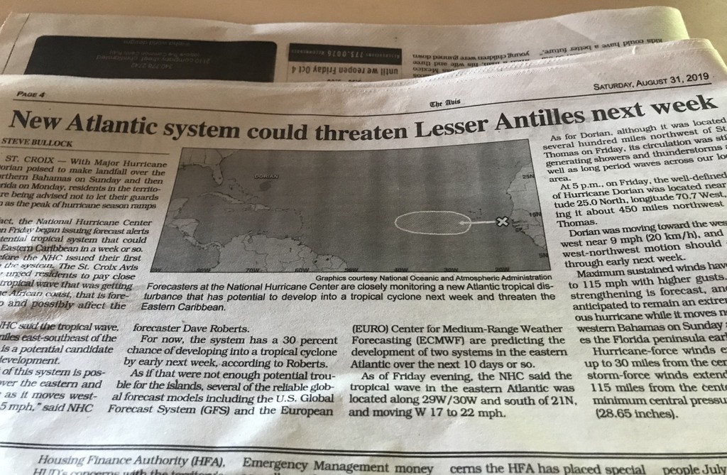 May God bless us all. Isabel |
| - Aug. 30 - HURRICANE DORIAN causing major PANIC |
|
|
UWhat a horrible thought of a Cat 4 or 5 slamming into a very populated area at a reduced speed, possibly bringing with it tornadoes, what devastation, what a copycat of HUGO! The difference was that St. Croix is an island. There are destroyed buildings which stand as a silent testimony to what happened when HUGO visited in 1989, with many tornadoes. It’s inforgetable: Here are some of the images that became etched permanently in the minds of those who heard and saw what they did: Of plywood boards crashing and being buried so deep into the ground that they have to be sawed off; of permanent ripple designs left on concrete walls by the crashing of corrugated galvanized sheets as they sliced through the air! Of goat heads and even tree bases being sliced cleanly off, perhaps by one of those flying blades; of some people being blown out of their apartments as of by an explosion, clinging terrified to the door posts the whole night long as their belongings in the form of broken glass-filled debris crashed passed their ears; of people cramped and cringing with fear and awe at HUGO, in closets and and cabinets; of people risking their lives outside in the midst of the storm to seek refuge in their cars after their roofs had blown off; of people crawling on their bellies to hide under a car; of crashing sounds all around from flying house beams, entire roofs, trees, and many varied items; of noise levels generated by the storm which were compared to the departure off a C-120 military cargo plane; and of the most horrifying evils sounds as if the air was virtually filled with demons..and so on, and so on, for each person another experience to tell. Alexander Hamilton experienced the same in St. Croix as a teenager. He wrote: “Hark! Ruin and confusion on every side. ‘Tis thy turn next: but one short moment—even now—Oh Lord help—Jesus be merciful! Thus did I reflect, and thus at every gust of wind did I conclude—till it pleased the Almighty to allay it.” We can well imagine the prayers that are going up to the Almighty in Florida right now. I have a lot of family and friends scattered throughout the peninsula and I am praying for them. I have experienced hurricanes; they are extremely frightful. The latest track is now Northwest, but that can be very deceptive as DORIAN has proven throughout. It is best to be vigilant and prepared and ready to evacuate if necessary. In the meanwhile, as Dave said, there are two waves out in the tropical Atlantic to our east. He thinks the first will be a fish storm, but the second could be trouble. In fact, it is already marked with an “X” and in five days it will already have a 30% chance of developing. Whew!! May God bless us all. Isabel |
| - Aug. 29 - Hurricane DORIAN., the Vanguard!? |
|
|
Is it possible that DORIAN opened the way to the next storms? That would make it the “forefront” of the increased activity during this hurricane season. Would be great if this is the only storm to deal with, but as Dave said there’s one of two waves crossing the Atlantic, which has him concerned. When he says something like that I’m sure it’s serious. That being the case we could be dealing with another storm perhaps by next week. Let’s hope that’s not the case. We’ve had a very nice day today, just a brief shower where we live. Our curfew was lifted last evening already, but the one for St. Thomas was extended. It’s possible they suffered serious damage. I’m sure Dave will fill us in. No one expected this turn of events. It was not suppose to go through the Virgin Islands, but it did. Along our south shore, there seem to have been trees down as a result. The information is very sketchy. The Buck Island we heard about with registered wind gusts of 111 could be the one in St. Thomas. We live and we learn. I did not know they have one also. Hurricane DORIAN has everyone worried in Florida and both east and west coasts, and the Gulf. I was horrified when I heard today that it can slow down to 5/6 mph when it reaches Florida, or wherever it makes landfall. It’s not set in stone that Florida will be visited by DORIAN as a CAT 4; that can change. We do and should pray for all the folks who will be impacted. I know a lot of people in Florida, relatives and friends. We are not going tp have a peaceful weekend with this on our minds. Be well, may God bless us all. Isabel 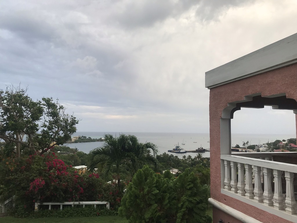   |
| - Aug. 28 - #3 post - Tropical Storm/Hurricane DORIAN |
|
|
What a day! TS DORIAN played a fast one on everyone! Who would have thought that DORIAN would choose St. Croix as his port of entry through the smaller islands back to the Atlantic?That’s what happened and as it moved through it increased in intensity. A wind gust of 111 mph was registered at St. Croix’s Buck Island National Park. In St.Thomas it became a Cat 1 hurricane 87mph wind, gusts of 111, but quite possibly that happened before it left St. Croix. We felt the wind too strong to be a tropical storm. We lost power during the course of the morning and regained it at 7:15 this evening. We had a nice, Caribbean farewell lunch, which i cooked early. I knew the power was going as soon as the storm got stronger, or even before. So, the girls were rebooked on an earlier flight tomorrow.and there’s renewed hope of meeting up with son/brother in Boston. He, on the other hand, was experiencing delays in New York with his shuttle flight to Boston. Travel woes everywhere. And that had nothing to do with TS ERIN which formed while everyone here had their eyes on DORIAN. I must say activity definitely increased. Who was it that said this would be the first time August has not seen a storm in 22 years? In 2013 the same names as this year were used. There were three in August: DORIAN, ERIN, and FERNAND..and then nothing until after our golden wedding celebration when GABRIELLE appeared on the scene. According to Dave, please read his post on Stormcarib home page, he is already glancing towards Africa and what did he see? Two waves, the second is worrisome, that could be GABRIELLE, unless both are developing, which would be FERNAND and GABRIELLE. THE middle names of the alphabet have often held devastating storms. For now, let’s stay focused on DORIAN and pray for those along his route that all may be safe. May God bless us all. Isabel |
| - Aug. 28 - DORIAN Was Here.....?. |
|
|
This is almost too funny for words! While we are here wondering when DORIAN will finally pass us, according to the CPA, it was at our location 6 miles away at 6:24 a.m. Other than heavier rain, and not excessively heavy either, now and then, this can almost be compared to a regular rainy day brought on by a tropical wave or a trough. In the meanwhile, a curfew has been imposed from 12 noon to 6 a.m. Thursday. People are out and about getting last minute items, especially sand bags and sand at designated locations, for those who need them. Torrential rain is expected. That’s yet to be seen; all indications show that DORIAN was already close to us. AS I WRITE SUDDENLY SOME ACTION HAS PICKED UP; GUSTY WINDS AND HEAVY RAIN! IT’S AKIN TO THOSE STORMS WHICH DROP THE RAIN AFTER THE FACT. HOWEVER, I HOPE THE CURFEW IS WARRANTED. THERE’S NOTHING PEOPLE LIKE LESS THAN BEING HELD HOSTAGE IN THEIR HOMES, ESPECIALLY IF IT CLEARS EARLIER. I will take a photo but there’s no guarantee that it can be attached, or when this post will go out. We’re having internet disruptions. Until later when I hope to post again. Be well. May God bless us all. Isabel Unable to attach photo
|
| - Dorian |
|
|
It's over. Just rainy, misty. Never really got any wind like STT. Our worst was this am late. There was that little popup in orange on the satellite map. It rolled and whirled in a donut against the NE coast of St. Croix. Seemed like 50-60 mph gusts, maybe 65 hurling rain straight from the N. Lasted 45 min to an hour and was gone. Would be interesting to look at the footage late am and see that orange donut spinning at us.
|
| - Dorian |
|
|
I've got nothing. TWC just reported 93 mph gusts in STT. I have my hurricane shutter pulled half way am looking out my screen door at the moment. It's not even raining.
|
| - Dorian |
|
|
Seems to be subsiding. Was blowing water so bad from off north shore of the island that we found out our sliders are bad. Gallery is 8ft across. Pulled one of the hurricane shutters. Sopped up some water on the other. Nothing substantial. And not bad out there now. My husband is on the gallery.
|
| - Dorian |
|
|
It's almost top of the hour 11 am and the wind gusts are strong. Blowing from north more. Still have my south kitchen window cracked. North facing slider bows a little with gusts. Radio is still playing via the generators. Nevertheless still have a signal. Hopefully this is the worst part and will be moving along.
|
| - Dorian |
|
|
I just lost what I typed. But at 10 am there isn't much rain and wind just gusts. But it is coming more from the north now than before so it has definitely shifted. I'm on east side of St. Croix facing north at Buck Island. HIlls to my south. Some of my neighbors just left for the store. And I have a hummingbird that showed up again about 20 minutes ago again. So far so good.
|
| - Fwd: Dorian |
|
|
I'm on East side of St. Croix at Coakley Bay condos. Nothing much yet at all. Some rain and wind picked up a little. Nothing bad yet and it's 8:45 am. I saw a fishing boat come in about an hour ago. And my hummingbird just showed up to eat from my feeder.
|
| - Aug 27- update #2. Tropical Storm DORIAN |
|
|
It’s still quiet, but we understand it’s going to start raining around 3:00 a.m. I checked the Closest Point of Approach (CPA) and here are the results: The storm itself will be at our location at 8:18 a.m. Hmmmm.... I wonder how exact that will be. School has not been called off as yet for my daughter who teaches at Good Hope Country Day School. When she saw the CPA, she said, “Yikes, that’s close!” Meanwhile, my cousin in Puerto Rico is sorry for us that we’re going to get it hard, but I don’t think she realizes that DORIAN is going through there. There’s a lot of confusion about this storm. Right now, Brian’s Bar is having there regular Tuesday night Kareoke. They don’t seem to have a care in the world. Just having a good time. Well, the way it looks they should be at home before DORIAN’s arrival. The storm has moved closer to us. The last time it was 96 miles, now 18 and it can get even closer.! It’s passing behind us to the south, so we did not close our shutters. We have double glass windows and don’t expect any flying debris. That is probably another misconception. Keep us in your prayers. I certainly appreciate the folks who have been keeping in touch, keeping an eye on DORIAN and us. Be well, be happy, and may God bless us all. Isabel
|
| - Aug 27 - |
|
|
Hello there! Thank you for all the kind concerns for us. So far we’re having a quiet evening. The weather should go “downhill” as we say, later. We have experienced a power outage already and we know for sure the power will be out for a longer duration. Unfortunately, our girls are unable to leave until they can get another flight. They not only miss their flight, they will miss meeting up with our grandson who is leaving for the American University in Madrid on Friday. (Just heard there are floods in Madrid.) So, T.S. DORIAN is causing a lot of travel headaches. I’m trying to rush this hoping it goes out. If possible i’ll try again later. May God bless us all. Isabel |
Older reports from St.Croix have been moved to another page.
| Back to top |