 |
Caribbean Hurricane Network
- 2 0 2 0 Season - |
|
|
|
2020 Atlantic Hurricane Season |
| | Arthur | Bertha | Cristobal | Dolly | Edouard | Fay | Gonzalo | Hanna | Isaias | Josephine | Kyle | Laura | Marco | Nana | Omar | Paulette | Rene | Sally | Teddy | Vicky | Wilfred | Alpha | Beta | Gamma | Delta | Epsilon | Zeta | Eta | Theta | Iota | |
Below links to local reports from the special hurricane correspondents on the islands:
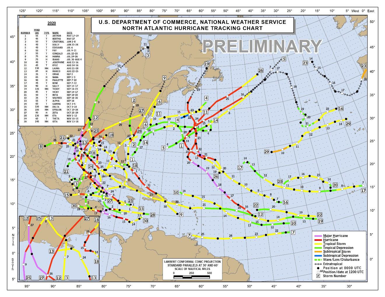
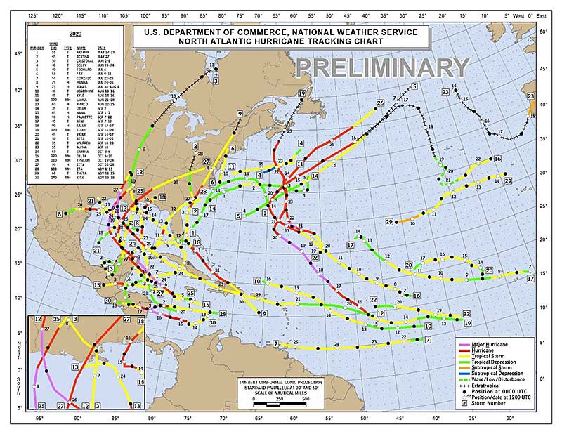
A record breaking season in many ways has finally come to an end! And there were many records, to name a few: most named storms (30, old record was 28 in 2005), earliest forming C-storm and earliest E-storm onwards, most storms formed in September (10, was 8), most major hurricanes after Oct.1 (4, was 2), etc. See a long list in Klotzbach et al summary of 2020 season. And on May 13, 2021, Zeta was reclassified (upgraded) to a Major Hurricane. This season now ties with 2005 for most major hurricanes...
For us however it has been pretty good. There were of course bad storms in the western Caribbean affecting Nicaragua, Honduras and the Yucaton, esp. Eta and Iota, the worst storms of the season. Then we had Isaias, that passed along the Bahamas (esp. in Grand Bahama and Abaco, hit badly last year by Dorian, it was tense). Also Bermuda seemed to be a magnet this year for hurricanes! But other than that for the islands it was pretty good. Indeed, hard to believe, but this season there was only one hurricane in the Atlantic between the islands and Africa, Teddy. See preliminary map below of Ethan Gibney (NOAA) copied from Klotzbach's summary.
Thank you to all our special hurricane correspondents who reported what happened around them. Without you this website would not exist! Esp. thank you to Isabel from St.Croix who posted every day and delighted us with her beautiful pictures of her garden, views and animals! Also thank you to all the people who donated and clicked on the ugly ads! Unfortunately donations were down a lot this year, probably because of COVID related economics, but we will see you next year nevertheless!!! -Gert
Following is an archive of all weather discussions Dave and I posted. They are in reverse chronological order, with the most recent storm discussion on top. If you want more background in formation on specific storms, I have found the 2020 Atlantic Hurricane Season section in the Wikipedia a great resource. Also, visit the National Hurricane Center's website for 'best track' data of all 2020 storms. The track map below is from that website as well.
 |
| - - - 2020 Storm Tracks - - - |
Weather discussions by Gert & Dave during the 2020 Atlantic Hurricane Season. The homepage with the links to local reports from the islands, latest satellite image, current weather outlook can be found here.
Friday, April 9, 2021 10:27AM PDT - La Sourfriere on St.Vincent erupting
- This morning La Soufriere on St.Vincent erupted, sending a 2 mile high cloud of ash up in the sky. Evacuation orders have been issued. I have asked my special hurricane correspondents on St.Vincent for some updates. Hope we get some local reports! Surrounding islands have offered to take in evacuees, of course, further complicated because of the COVID-19 pandemic. Previous eruptions were in 1979, 1902, 1812 and 1718, so it is not a common event. The ash of the eruption might affect some other islands as well... Wishing everyone well. -Gert
Thursday, April 8, 2021 17:11PM PDT - Above average 2021 hurricane season?
- It is that time of the year again that Klotzbach et al. at Colorado State issue their forecast for the season. Again, they are calling for an above normal season with 17 tropical storms (12.1 is normal), 8 hurricanes (6.4 is average) of which 4 reaching Category 3 or higher (2.7 is normal). The probability of at least one major hurricane tracking into the Caribbean is 58% (normal is 42%). Note that this is a large area, this is not the chance that your island will get hit.
The main reasons for a potential busy season are above average sea surface temperatures in the Atlantic and an absence of El Nino conditions, which normally suppresses hurricane activity. So nothing to surprising. What made me look though was the 'analogue years' they picked. These are years with similar atmospheric and oceanic conditions as the current year. They picked 1996, 2001, 2008 (Ike and Paloma), 2011 and last but not least, 2017 (Irma and Maria!!!). Hope it won't be similar to 2017! Number of storms doesn't say it all, you only need one to spoil your whole season, and last year we had 30 named storms with not much affect on us... In any case.., now is a good time to prepare, hurricane season starts in less than 2 months! -Gert
Saturday, March 20, 2021 10:35AM PDT - No more Alpha, Beta, ...
- The World Meteorological Organization (WMO) has deciced to stop using the Greek alphabet when we run out of names. We have only ran out of names twice so far. In 2005 we needed 6 Greek letters, and last year a record 9! However, it seems more likely that we will run out of names again in the future, mostly because of climate change.
Apparently using the Greek alphabet was too distracting and confusing. Some of the reasons listed here by the WMO is that there might be too much focus on the novelty of using Alpha, Beta, etc., which can take the focus off the actual impacts of the storm. Also apparently these names can be confusing when translated into other languages. The names also sounded quite similar, like Zeta, Eta and Theta, which can be confusing. Plus there was uncertainty how to deal with retiring Greek letters.
The new plan is to use a supplemental list of names, starting again with the letter A, and which can be retired (and replaced). I am not sure how that helps with the first reason listed, I think that it will be just as 'news worthy' to have to revert to the Supplemental List as the Greek Alphabet. There are still no plans to use names starting with the letters Q, U, X, Y or Z because there are not enough 'common' names to be used in the 6-year rotating lists of names. I hope this is all a moot point and that we never have to use the supplemental list though! -Gert
Saturday, January 2, 2021 12:31PM PST - Happy New Year
- Happy 2021 to all my Caribbean friends! Let's hope that things will go back to more normal without any bad (is)landfalling storms. Hoping for the best for people on St.Vincent and Martinique with their rumbling volcanoes! Stay safe everybody. -Gert
Tuesday, December 1, 2020 09:53AM PST - Finally!
- A record breaking season in many ways has finally come to an end! And there were many records, to name a few: most named storms (30, old record was 28 in 2005), earliest forming C-storm and earliest E-storm onwards, most storms formed in September (10, was 8), most major hurricanes after Oct.1 (4, was 2), etc. See a long list in Klotzbach et al summary of 2020 season.
For us however it has been pretty good. There were of course bad storms in the western Caribbean affecting Nicaragua, Honduras and the Yucaton, esp. Eta and Iota, the worst storms of the season. Then we had Isaias, that passed along the Bahamas (esp. in Grand Bahama and Abaco, hit badly last year by Dorian, it was tense). Also Bermuda seemed to be a magnet this year for hurricanes! But other than that for the islands it was pretty good. Indeed, hard to believe, but this season there was only one hurricane in the Atlantic between the islands and Africa, Teddy. See preliminary map below of Ethan Gibney (NOAA) copied from Klotzbach's summary.
Thank you to all our special hurricane correspondents who reported what happened around them. Without you this website would not exist! Esp. thank you to Isabel from St.Croix who posted every day and delighted us with her beautiful pictures of her garden, views and animals! Also thank you to all the people who donated and clicked on the ugly ads! Unfortunately donations were down a lot this year, probably because of COVID related economics, but we will see you next year nevertheless!!! (And isn't it 'Giving Tuesday', it is not too late to donate!) -Gert
 |
| - - - 2020 Storm Tracks (Ethan Gibney (NOAA)) - - - |
Wednesday, November 18, 2020 14:22PM PST - Deadly Iota
- Just wanted to refer you to Jeff Master's blog at Yale Climate Connections who did an excellent write up of the effects of Iota on Central America and Providencia Island. Not good. A good place to donate would be World Vision. -Gert
Tuesday, November 17, 2020 11:44AM PST - Iota
- Just 2 weeks ago Eta made landfall as a Category 4 in Nicaragua, now, just 15 miles south, Iota made landfall as a strong Category 4 storm after slightly weakening from Category 5 status! Unprecedented in many ways, of course it is totally unusual for 2 Cat-4 storms to strike the same location, unimaginable. Moreover Cat-4 storms are very rare this late in the season. Before this season only 4 Category 4+ hurricanes occurred in November or later (of which Lefty Lenny in 1999 was one) since 1951, so now we have 6...
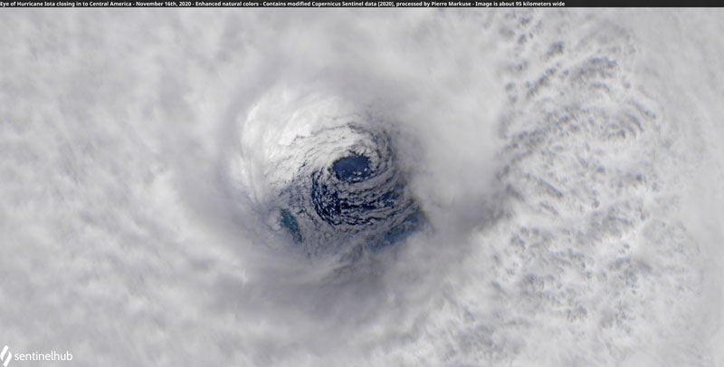
I sound like a broken record unfortunately, but this storm will dump a lot of rain in the same place as Eta did. According to the advisories, locally (though isolated we hope) up to 30 inch (75 cm)... This will result in deadly flooding, mudslides, ... Two weeks ago Eta didn't get much attention in the media while it was creating havoc in Central America because of all the brouhaha going on in the USA. Hopefully this time will be different. Help will for sure be needed! If you want to donate, Jeff Masters recommended World Vision in his excellent blog post of today. On his blog he also posted the image below by Pierre Markuse of the eye of Ioata just before it made landfall...
-Gert
Monday, November 16, 2020 10:11AM EST
- Deadly Iota
-
Good morning,
11/16 Update: Hurricane Iota did reach Category 5 hurricane status officially just a short while ago at 160 mph sustained with further potential before landfall. On top of Eta 2 weeks ago, this will be devastating. One of the worse things is many will not be informed Iota is coming due to the damage and lack of communications inflicted just 2 weeks ago by Cat 4 Eta. El Salvador and Guatemala will also be severely affected.
Sadly, this will be a large scale humanitarian disaster between Eta and Iota. Mother Nature is not happy this year.
Dave
Sunday, November 15, 2020 10:42AM EST
- Hurricane Iota
-
Good Sunday morning,
Wow. As Gert shared earlier Deja Vu is at hand and sadly Nicaragua and Honduras along to a lesser point Jamaica, Panama, Belize and Costa Rica are in the crosshairs of another potentially devastating major hurricane, Iota.
Going deeper into the Greek alphabet, Iota is the 13th hurricane this over achieving year, 6th major and a record setting 30th named storm. Currently moving about 9 mph towards the WNW, Iota is expected to make landfall late Monday night into very early Tuesday morning around the Honduran Nicaraguan border, very close to where deadly Cat 4 hurricane Eta landed a mere 2 weeks ago. Latest sustained wind speed is 90 mph with higher gusts and by landfall, Iota is forecast to become another Cat 4 deadly hurricane. Outflow in all quadrants has improved rapidly, wind shear is low and water temps are around 88-90 degrees supporting rapid intensification. 2 caveats could help lessen the impacts although minimally. The first is upwelling colder waters near the eastern Nicaraguan coast due to a shallow shelf and hurricane Eta's passing and the second, an EWR (Eye Wall Replacement) which cannot be forecast occurring close to the coastline. These factors might keep Iota below Cat 4 at landfall but still a dangerous and deadly major hurricane. As far as RI is involved, major status is not expected until around noon tomorrow but I expect, with the eye clearing out and the current conditions, we may have a major hurricane by tomorrow morning. Honestly, on landfall, as this situation is evolving, the possibility of a Cat 5 November landfalling hurricane cannot be ruled out. Wow.
With that said, Hurricane Hunters are enroute and a better idea of strengthening, development and potential will be available with their all important, on time data. Two weeks ago in almost the same exact area, Category 4 Hurricane Eta caused mudslides, landslides, flooding, flash flooding, wind damage and fatalities. Hurricane Iota is going to exacerbate and only add to Eta's destruction and death with added torrential rain and wind. Storm surge from 11-18 feet and damaging waves will only contribute to an already battered coast. This, everyone, is a potentially catastrophic situation as if Eta wasn't enough. The effects will be far reaching and lasting.
Dave
Friday, November 13, 2020 15:39PM PST - Iota: deja vu all over again
- And here we have the 30th storm of the season, Iota. And, yes, I used the headline before, deja vu all over again! Iota is expected to take a similar path as Eta just 12 days ago, forecast to again bring torrential rain to Central America, esp. in Honduras and northern Nicaragua. The Public Advisory is mentioning 20-30 inch locally in the already Eta soaked terrain. Not good indeed.
Right now Iota is expected to make landfall as a Category 3 hurricane in 3 days, yes indeed, a Cat-3! Another one of those storms that is doing the Rapid Intensification thing under the near ideal conditions ahead: warm waters, moist atmosphere and low wind shear. So, not good again!
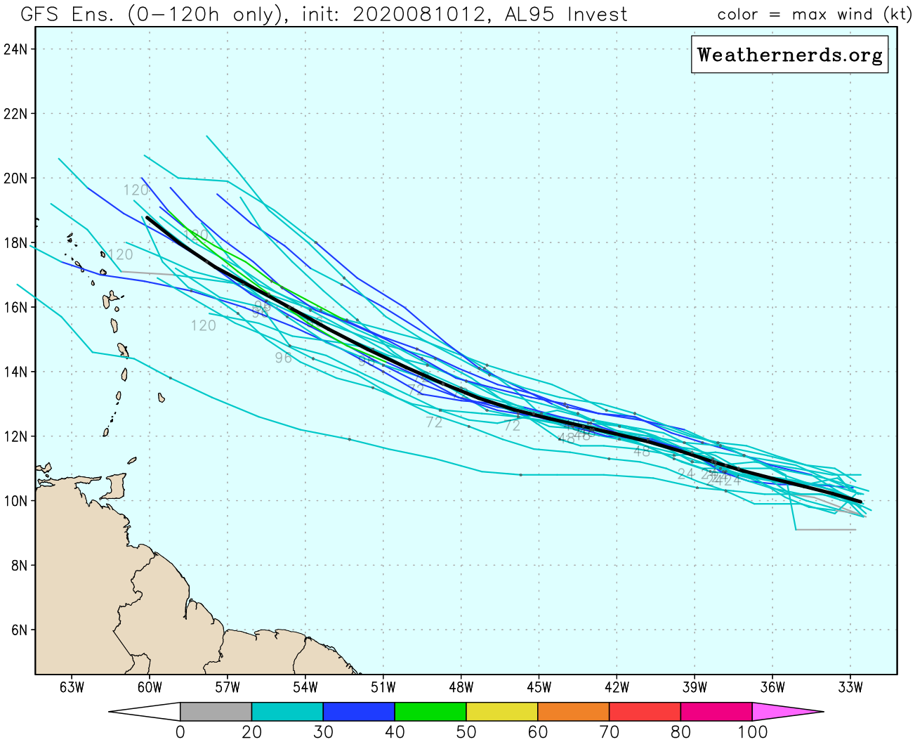
What is also a bit worrying is that some of the model runs (see the red lines in the GFS model run below) indicate that Iota might just stay north of Honduras while moving to the west, then rather than quickly weakening over land, it can stay more organized over water, staying stronger, while dumping even more rain in Honduras... Regardless, it is not a good situation to have two drencher storms in this vulnerable area... -Gert
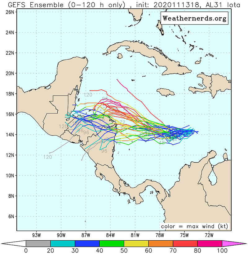 |
| - - - GFS Ensemble Run, hope the red lines are wrong - - - |
Thursday, November 12, 2020 06:00AM EST
- Still going!
-
Good morning!!
Well the 2020 year has continued to amaze, appall and antagonize with an Atlantic hurricane season that has not ceased. Like the little engine that kept saying "I think I can", this one thinks it can go on till Christmas! And just might.
Eta the energizer made landfall around Cedar Key Florida this morning around 4:20 am as a 50 mph sustained tropical storm, disheveled in appearance due to wind shear and dry air intrusion from the west but still a potent force. Now racing across the peninsula with most of her convection out in front, she should enter the east coast side into the Atlantic as a minimal tropical storm or depression. Storm surge and flooding with modest tropical storm force winds have been her calling cards while menacing Florida's west coast in sharp contrast to her killer devastating blow a mere 9 days ago to Central America, which sadly might have a Groundhog Day moment in another week.
Speaking on that possibility, 98L traversing the eastern and central Caribbean has a 90% of development over the next 5 days and will be christened Iota as Theta has already been taken by a now 65 mph tropical storm in the eastern Atlantic. Theta is a threat to fish and shipping at this time and will slowly die out without any real effects on land. 98L , soon to be TS Iota, however, will menace the same areas that Eta did in Central America, compounding the cleanup and recovery operations with more heavy rains, mudslides and flooding.
For now, 98L has been a soggy companion of the Windward Islands and the Lesser Antilles including Puerto Rico. While we do need the rain to stock up for the upcoming dry season, we don't need this much all at once.
Stay safe and prepared!
Dave
Tuesday, November 10, 2020 12:10PM PST - It's official: a record breaking season
- Last night the 29th named storm of the season formed, named Theta. So now it has surpassed the previous record in 2005 of 28 storms. Unbelievable. And the season is not even over yet, Invest 98L in the Caribbean Sea has a 70% chance of becoming the 31st storm!
First, (well second, I guess), I want to say that Eta luckily was not as catastrophic for Central America as I feared. I don't want to downplay it, because at least 130 people got killed by the storm and many are still missing. Buried in mudslides... But it could have been a lot worse. Right now Eta is sitting just off the coast of western Cuba, so more flooding there, as well as in Florida. Eventually Eta will start moving and is expected to make (another) landfall in the Florida panhandle, although models don't really agree on that yet.
Theta, our new storm, does not pose a threat to us. It is in the far Eastern Atlantic and moving east, so away from us. It is moving towards Portugal, didn't they have a storm earlier this year? Very unusual as well I am sure.
Invest 98L, future Iota maybe, is the mess you see in the satellite image above in the eastern Caribbean Sea. It is moving eastward and might pose another soaker threat to Central America... Depending on when it gets organized Jamaica and the Caymans should pay attention to this storm as well. -Gert
Saturday, November 7, 2020 09:17AM EST
- Eta again and again
-
Good morning all,
Hurricane Eta has already claimed over 150 lives due to flooding and mudslides in Guatemala, Honduras, Nicaragua, Panama, Costa Rica and Mexico. There are many more missing and feared dead plus many trapped on their roofs without food, water or shelter. The remote villages where mudslides occurred saw the inhabitants who perished buried in their own houses. Meanwhile, as Eta pulls away from the region as a TD, soon to become a TS again, she is battering and blowing up quickly over the Cayman Islands with heavy rains, strong gusty winds and a rare tornado on Grand Cayman, snapping power lines creating even more damage. A 52 mph wind gust was just reported with quickly dropping pressures and Eta should reclaim TS status very soon as hurricane hunters are in the middle of the mission area confirming and sampling the storm. Eta is officially not supposed to reach hurricane status as of what we know right now but it appears to me she will regain hurricane strength albeit not the Cat 4 monster she was previously. Dry air intrusion and increasing wind shear should stifle any attempt at large scale strengthening.
Cuba is next in line with the Florida Peninsula looking for possibly 2 landfalls, one in South Florida and the other on the west coast between Tampa and the Big Bend. Again, that's the now projections. Plus, with most of the strong convection on the east and northern sides, the Bahamas will feel TS effects too and TS warnings are up based on current path forecasts. Several even show after exiting Florida Eta will become an east coast rider. While not good for the east coast, the central Gulf Coast will breathe a big sigh of relief.
One other effect to mention is the wind field which will expand after interaction with Cuba so mainly the east and southern coast of Florida will take a pounding from the seas from Eta and the easterly wind flow already in place from the high pressure system to the north. TS force winds will be felt far up the coasts in addition to beach erosion, rip currents and a good sandblasting.
Long term in the next few weeks we might see some late season development in the Western Atlantic and/or SW Caribbean again. This record breaking season just does not want to quit.
Stay safe and prepared!
Dave
Tuesday, November 3, 2020 10:38AM PST - Eta about to make landfall
- Eta is very close to making landfall. Right now winds are 140mph (Cat.4!) after peaking at 150mph (close to Category 5!) before an eyewall replacement. It has slowed down already, now meandering at just 3mph, just about 20 miles south south east of Puerto Cabezas, Nicaragua. A bad scenario for storm surge (esp. north of the eye) and catastrophic wind damage near where the eye will make landfall. Although Eta is expected to weaken fast once it is over land, the threat by far is not over. On the contrary, it is just beginning as it moves slowly over Nicaragua, Honduras and Guatemala dumping lots and lots of rain (locally up to 35 inch!). Friday AM the center of the storm (or what is left of it) is still expected to be over Guatemala. This is by far not a good scenario, to which Dave and I alluded yesterday. Please Eta, move faster! -Gert
Monday, November 2, 2020 19:33PM EST
- Hurricane Eta and whereafter?
-
Good night all,
I see Gert caughtÂyou all up earlier while I was traveling today in which Hurricane Eta decided to RI (rapidly intensify) from a mere tropical storm of 40 mph to a Category 4, near symmetrical monster now within 60 miles of the Nicaragua/ Honduras border. Moving WSW at 9 mph, Eta is expected to slow to a crawl as she slams into the Central American coastline with up to 20 feet of storm surge.
As if that wasn't catastrophic in itself, the slow to negligible movement of Eta will produce DAYS of heavy rainfall over Honduras, Nicaragua, eastern Guatemala, and Belize with up to 2-3 feet falling creating mudslides, landslides, flash floods, serious wind damage and sadly, numerous fatalities. Hurricane Mitch, referenced by Gert earlier, killed over 10,000 people in 1998 in the same area. The mountainous terrain just wrings the moisture out of these systems and when you're at the bottom of those mountains, there is no mercy. Jamaica and SE Mexico could get 5-15 inches while Panama and Costa Rica in certain areas could get up to 2 feet, especially if Eta moves farther south than west before moving inland. A side note: With Eta maybe moving a bit more southerly while slowing down under veryÂweak windshear, it is possible she can reach Cat 5, intensifying upon landfall. Regardless, this is going to be a very bad event for Central America, Cat 4 or Cat 5.
What happens after Eta wreaks her havoc over Central America? Will she die out courtesy of the mountainous terrain, known for the destruction of tropical systems or will she emerge off the eastern Central American coast in about 5 days, back out into the western Caribbean and like a phoenix, resurrect herself to wreak more havoc over the Caymans, Jamaica, Cuba and eventually Florida or the consensus hurricane magnet of 2020, the north central Gulf of Mexico? The two top global models are in virtual agreement this will happen but where she goes once resurrected is not. All need to be ready for this major uncertainty. Hope for the best, she rapidly disintegrates in the mountains. If not, prepare for the worst as it is anyone's guess at the moment what happens if she does reappear. Bottom line for the time being is to pray for those about to feel Eta's fury.Â
Off to the east of the Windward Islands there are a few disturbances but none have the attention of the NHC. Saharan Dust has been more prevalent than usual the last few weeks for this time of year and wind shear is once again our friend. Rains will be moving in towards the end of this week and into next week as November is usually one of our wetter months.Â
I wonder if they will retire a Greek alphabet name. While there is no precedent for this, I believe it will be appropriate after the next 10 days.
Stay safe and prepared!
Dave
Monday, November 2, 2020 08:58AM PST - Hurricane Eta - It will be bad!
- Sorry for not reporting earlier, I was on a camping trip. While I was gone a lot of things have changed. We now have Hurricane Eta on track to make landfall in Nicaragua tomorrow. There are a couple things about this storm that worry me very much. First, Eta might strengthen to a major Category 4 hurricane before making landfall! Although the eye is quite small, catastrophic wind damage will occur where the eye makes landfall. Furthermore, a life-threatening storm surge as high as 12-18 feet (3.5-5.5 meter) is forecast north of the point of landfall.
What is more worrisome though is that Eta is expected to slow down after making landfall. This will lead to very high rainfall totals leading to flash-flooding, river flooding and mudslide in the mountainous areas. The advisory warns of unfathomable rainfall totals through Friday of locally up to 35 inches (89 cm!) in Nicaragua and Honduras. This storm reminds me of Hurricane Mitch in 1998, and that is not a good thing. That storm killed 7,000 people in Honduras and 3,800 in Nicaragua... Mitch was also a late storm, quoting from the Wikipedia page: "Due to the slow motion from October 29 to November 3, Hurricane Mitch dropped historic amounts of rainfall in Honduras, Guatemala, and Nicaragua, with unofficial reports of up to 75 inches (1,900 mm). Deaths due to catastrophic flooding made it the second deadliest Atlantic hurricane in history after the Great Hurricane of 1780". Let's all hope that Eta won't slow down too much so that it won't drop as much rain in its path. -Gert
Friday, October 30, 2020 11:14AM PDT - Eta?
- Looks like we have another storm forming in the Caribbean! This would tie the record for most storms with 2005, not break it as we all thought. Although officially the last storm in 2005 was Zeta, the NHC discovered one more storm in the post-season analysis that should have been named. So even though this year is the first time we get to Eta, it is still a tie...
Invest 96L did pass over the south Windward islands already causing some stormy weather in St.Vincent (see local report on the right). It is traveling westward, and as it looks right now moving well south of Jamaica making landfall in Nicaragua or Honduras next week as a possible hurricane. There is still some uncertainty about the track and forward speed, so we have to keep a close eye on this one! -Gert
Tuesday, October 27, 2020 20:09PM EDT
- Zeta and who knows?
-
Good evening!
Once Hurricane Zeta, now TS Zeta, soon to become once again Hurricane Zeta is currently churning off the NW Yucatan Peninsula coast moving to the NW around 14 mph with the expectations of a mid Gulf Coast strike tomorrow late afternoon through the evening, possibly delivering a late season direct hit on New Orleans which has so far played dodgeballÂwith the numerous tropical systems to strike Louisiana this crazy busy 2020 season. This will be the third hurricane to hit Louisiana plus a few tropical storms and so far, the Big Easy has been scared but not struck. Current track shows a close call but a few wobbles and a direct hit is very possible. And wobbles, do occur. Meanwhile, Zeta takes up about 2/3 of the GOM with TS force winds out about 140 miles. Weird note, a TS watch is up for Atlanta, far inland from landfall. 50-60 mph wind gusts are possible with power outages, some structure damage and numerous trees down all during rush hour.
While the central Gulf Coast has been the main tropical system magnet this season for tropical landfalls, the Yucatan Peninsula comes in second and has taken several good shots to the chin this season but so far has fared better than expected. Flooding and structural damage has occurred each time but their resilience and fortitude keep picking that area back up each time. Preparation in advance has been life saving.
Off to the east of the Windward Islands, an approaching tropical wave has garnered some attention but nothing the NHC has shouted about this late in the season. However, the bulk is expected to move to the north of the islands at this moment. Time will tell. The season still has 4.5 weeks left officially and I'm sure there is an ETA in the wings (no, not estimated time of arrival).Â
Stay safe and prepared!Â
Dave
ÂÂ
Sunday, October 25, 2020 14:58PM PDT - Deja vu all over again?
- And here we have the 27th tropical storm of the season, Zeta! Remember Delta earlier this month? Zeta is about to take the same path, aiming for Cozumel and Cancun in the Yucatan peninsula and then the Gulf coast. While Delta went from a tropical depression to a Category 4 storm in just 1.5 day (!), Zeta should behave better. Right now the official forecast has Zeta strengthening to a Category 1 hurricane just before making landfall in Mexico late Monday. However, the water is still quite warm and will not encounter much wind shear, I would not be surprised if it gets stronger than just a Category 1. So keep following the forecasts if you are in the affected area!
Meanwhile, Epsilon has moved on, but the remnants will affect Europe next week as a fall storm... -Gert
Saturday, October 24, 2020 12:28PM EDT
- Still Going!
-
Good afternoon!
The energizer that is the 2020 Atlantic Hurricane Season is still going with an official end in sight of November 30th but that us still 5 weeks off and ongoingly active. Currently we still have hurricane Epsilon in the North Atlantic while a soon to be born Zeta is fledging in the SW Caribbean potentially on a date with the tropical system magnet of the year, the Louisiana to Florida Panhandle corridor.
Hurricane Epsilon, once a short lived major hurricane (4th one this season!) as Gert pointed out, is now a threat to fishing, shipping and maybe even Iceland as it treks away from Bermuda at about 13 mph while expected to accelerate to over 40 mph towards the northeast. Still producing large swells and rip currents along the east coast of the US and Canada, Epsilon is expected to retain hurricane status into Sunday with hurricane force winds out 60 miles from the center and TS force winds extending over 400 miles, mainly to the north and northeast. While Epsilon will lose it's warm core tropical characteristics, it will transition into a beast of a post tropical system as it speeds through the far North Atlantic while eventually affecting the UK and Europe.
95L is percolating in the SW Caribbean, a prime breeder of late season tropical systems due to low shear and high oceanic heat content. This area has been watched closely for the last 6-10 days for activity to finally coalesce which should result in the formation of a depression and eventually, TS Zeta, a name last heard from in 2005.
Last movement was about 5 mph to the SW but an expected turn towards the north/northwest is expected shortly with depression status attained today or tomorrow. While still over the bath watersÂsouth of Cuba, it should attain TS status while continuing to move generally north. Where it goes depends on how strong it becomes but most models at this moment keep it below hurricane status. Nonetheless, it looks to have it's eyes set on the central northern Gulf Coast from Louisiana to Florida. Hard to say until it actually forms. Wind shear is high across the Gulf Coast while the waters are cooler due to cold fronts dropping down and the recent upwelling from the last few storms so RI in the Gulf is highly unlikely. At the most, a Cat 1 that I can see upon landfall. Where is a different story. A storm weary Gulf Coast needs to be on alert one more time.
With 5 weeks left in the official hurricane season this should not be taken as the grand finale. I think we have another one, maybe two left. After all, this is 2020.
Stay safe and prepared!!
DaveÂ
Thursday, October 22, 2020 09:26AM PDT - Epsilon <--> Bermuda
- Yesterday Epsilon did become the 4th major hurricane of the season (Cat-3, 115 mph winds). Now it has weakened to a Category 1 hurricane packing 90 mph winds. Currently it is located about 235 miles east southeast of The Rock and will pass to the east of the island later tonight and tomorrow as a Cat-1 hurricane. The closest point of approach is 175 miles Friday AM. Bermuda is under a tropical storm warning, but it might be just outside tropical storm force winds if the storm progresses as forecasted. However, the island will see large swells. Be careful on the nice pink beaches! -Gert
Wednesday, October 21, 2020 11:16AM PDT - Category 2!
- What a season..., last night the 8PM advisories still classified Epsilon as just a tropical storm. This morning it is a Category 2 Hurricane, and now with 110 mph winds a borderline Category 3 (major) Hurricane! Another case of rapid intensification this year and quite unusual this far north and late in the season with decreasing water temperatures. Epsilon is still expected to pass 150+ miles to the east of Bermuda, with a 40% chance of experiencing tropical storm winds. It is a big system, but hopefully all will be ok for Bermuda. See image below how big, the scale bar is 200km (125m)! Glad that Bermuda is on the west side of the storm. Things will start deteriorating Thursday with the closest point of approach Friday AM. Stay safe! -Gert
 |
| - - - Epsilon is huge, CPA with Bermuda - - - |
Tuesday, October 20, 2020 11:21AM PDT - Epsilon on the move
- Tropical storm Epsilon is now moving towards Bermuda at about 12 mph. Its closest point of approach has increased to about 200 miles early Friday. That sounds like a lot but Epsilon is a relatively big storm with tropical storm winds extending outward up to 300 miles, but mostly to the north though. It is still expected to strengthen into a Category 1 hurricane. So not surprisingly, Bermuda is under a tropical storm watch. I don't think it will be too bad, but we have to keep an eye on the track, things can change. -Gert
Monday, October 19, 2020 09:34AM PDT - Epsilon
- The 26th (!) storm of the season formed about 720 miles southeast of Bermuda. Right now it is kind of meandering but it is expected to pick up speed soon and move northwards towards Bermuda. Epsilon is expected to pass about 110 miles to east of the island on Friday, making it number 4 this year to get close! At this time it doesn't look like it will get much stronger than a Category 1 Hurricane, but as always things can change so we'll have to keep a close eye on this one... Hopefully this is the last one, but looking at the Tropical Weather Outlook below, there is another system in the southwestern Caribbean that might develop into something. The season is indeed still not over! Next letter in the Greek Alphabet is Zeta. -Gert
Sunday, October 18, 2020 07:45AM EDT
- Not over yet!
-
Good morning all,
Another welcomed lull in tropical action is about to end with one system, designated 94L with the most immediate potential while a tropicalÂwave movingÂthrough the Caribbean will stew later in the week but with more questions than answersÂfor now.
94L is currently about 475 nm ESE of Bermuda and really not going anywhere. Preferring to meander rather than have any sense of urgency to go anywhere in any definitive direction, 94L still has the possibility, high over the next few days, of becoming a depression or storm before finally moving off to the north. Bermuda might feel some effects down the road but no threat to any other landmass. Along the east coast, rip currents and coastal effectsÂwill be experienced but that's about it. The next name, if it does reach the threshold, will be Epsilon.
Well south of Jamaica along 79W is a westward moving wave which, for this time of the hurricane season, could well be another October story if all the ingredients come together. This will take a few days to manifest itself and if it does, projected paths will be movement to the north and northwest. Way too early to tell yet so it behooves any interests in Cuba, GOM and Florida/Bahamas to monitor closely this potential late season bloomer. October storms can be quiteÂvicious. PerfectÂexample was Hurricane Michael who was the firstÂCat 5 to make a mainland landfall since Hurricane Andrew in 1992. Michael was a 25 billion dollar storm which lasted from Oct. 7-Oct. 16, 2018 and was born in the SW Caribbean, a typical area to watch in October.
Elsewhere to the east of the islands, the wave train continues but we usually do not look for action to form until these waves get closer to the islands and the Caribbean aka "home grown storms". There are a few marching along but none catch anyone's eye yet. While the dust has finally settled over the Atlantic for the most part, wind shear and cooling SST's have tampered down that development region. That's not to say a late bloomer cannot happen though so still, monitoring is a necessity for now.
Be safe and stay prepared!!
Dave
Thursday, October 15, 2020 09:41AM PDT - Cape Verde Storms Article
- An impressive article came out on BBC Future on Cape Verde hurricanes by Celia Jones. She interviewed a few of the hurricane correspondents for the piece! See it here: The unlikely birthplace of the most destructive hurricanes. -Gert
Thursday, October 15, 2020 05:27AM EDT
- Epsilon and beyond?
-
Good morning!
As Gert shared, we have a very active yet very sheared tropical wave entering the island chain with almost all of it's convection well east of the "center". Chances of becoming a named storm in the next few days are slim but gusty winds and heavy rainfall are good probabilities the next few days. The next name is Epsilon.Â
Now, as we still have 6 weeks to go until the official end of hurricane season, the potential for more "home grown" storms grows while classic Cabo Verde born storms decreases. The NHC is watching three such areas but at the moment, they all have been given limited chances of development. Still, if the NHC is interested, we should be interested as well: our wave to our east, possibilities south of Bermuda and the ever present threat from the SW Caribbean. We also still have waves coming off the coast of Africa to pay attention to.Â
Dave
Tuesday, October 13, 2020 14:46PM PDT - The Wave
- We are watching Invest 93L, closing in on the islands. Although it might have 35mph winds, so could be classified as a tropical depression, it is too disorganized. The wave is struggling because of dry air and high wind shear. The Hurricane Center only gives it a low chance in the next 5 days to develop into something ("Epsilon" is next on the list). Regardless, be prepared for some gusty weather on the islands, with significant rainfall tomorrow and Thursday. Stay safe, -Gert
Friday, October 9, 2020 06:55AM EDT
- East and Delta
-
Good morning!Â
The historical second "peak" of any hurricane season is upon us and has not unfortunately let us down. Back on my October 1st post, I shared the long term models were looking at a west coast Florida hurricane around October 10th, in that second peak. Well, here we are with Hurricane Delta about to barrel into SW Louisiana around dinner time today as a minimal Cat 3 or strong Cat 2 hurricane, almost in the same spot as Cat 4 Laura did just about 6 weeks ago. Piled debris is everywhere creating instant deadly flying projectiles, power is still out in sporadic areas, and blue tarps are everywhere replacing roofs that were on before laura. reminds me of Hurricane Bertha in 1996, just months after Cat 3 Marilyn in Sept. 1995. Bertha was a Cat 1 on landfall here in the US Virgin Islands doing minimal damage to an already ravaged St. Thomas but the blue tarps covering many homes and businesses were not a match for even a Cat 1. What many had salvaged from Marilyn was soaked and ruined by Bertha. This will be the same sad case in SW Louisiana. Storm surge will be widespread as Delta has widened to about 800 miles in diameter and TS force winds are expected to reach Houston and New Orleans. Hurricane force winds will reach far inland as well due to Delta's size and forward speed and what weakened trees survived Laura will now fall causing newly re energized and rebuilt power lines to crash again while also endangering people in their homes.
Off to our east, the wave train has started it's mid October migration and we must watch as they get closer to the islands as again, the second peak is upon us. One, SW of the Cabo Verde Islands, has some potential over the next 5 days but as it gets closer, wind shear should keep it at bay. There are a few more waves behind it and all bear watching as it's not over yet. Don't be complacent.Â
Stay safe and prepared!!
Dave
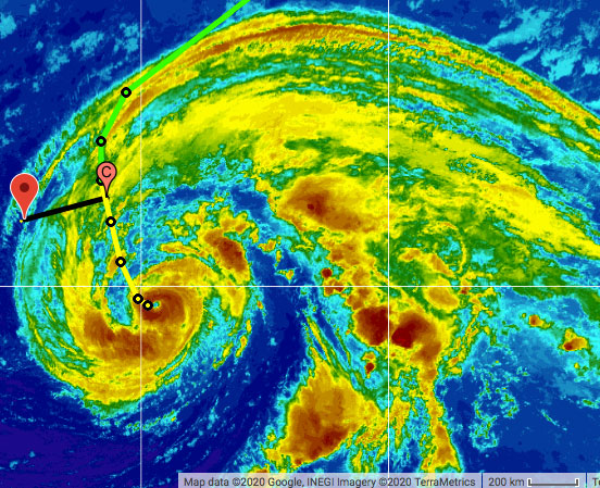
Thursday, October 8, 2020 11:26AM PDT - Delta heading for Louisiana (again...)
- I am happy to report that so far no deaths have been reported in the Yucatan Peninsula due to Hurricane Delta. The storm made landfall near Puerto Morelos, about 20 miles south of Cancun. While Delta was a Category 4 storm earlier it had weakened to 'just' a Category 2 storm with 110 mph. Also since the storm was quite small effects were not as bad as feared (by me). Of course, there was damage to buildings, downed trees, flooding and widespread power outages, it could have been a lot worse!
As it looks right now Delta will be the sixth storm aiming for Louisiana this year..., it might make landfall just 50 miles from where major Category 4 Hurricane Laura made landfall. It is hard to imagine how the people on the Gulf Coast feel this season when storm after storm is coming for them... See below a comparision of storm tracks in the Gulf of Mexico between the 2020 season and 2019 season... Color scale represents storm strength (blueish = non-hurricane, yellow to red = category 1 to category 5 hurricane, images adapted from Wikipedia.
Elsewhere (no, unfortunately the season is not over yet) there is another threat of a Cape Verde storm. It is nothing yet, but we will keep an eye on this wave while it is moving towards us. Stay safe everybody!
-Gert
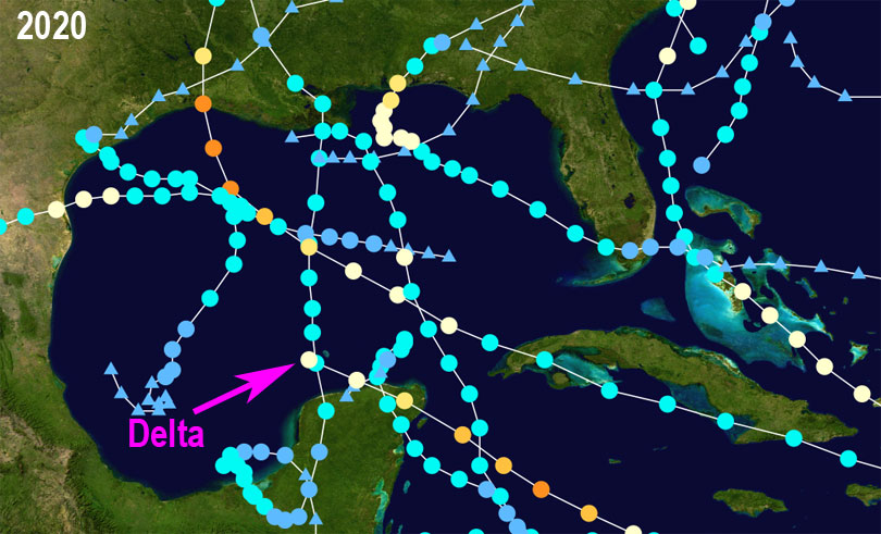 |
| - - - 2020 Gulf of Mexico Storm Tracks (so far, Wikipedia) - - - |
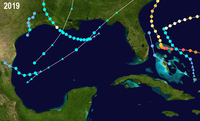 |
| - - - 2019 Gulf of Mexico Storm Tracks (Wikipedia) - - - |
Tuesday, October 6, 2020 13:25PM EDT
- Menacing Delta
-
Good afternoon,
Delta has continued her rapid intensification and is now that Cat 4 that I did say was possible but unlikely. Well, likely is here and it spells a direct hit and disastrous consequences for the northern Yucatan Peninsula, Cancun especially, with the western tip of Cuba taking a bashing as well, albeit not a direct hit or it's effects. A small, compact, well formed terror. Yesterday, a tropical ragged storm. This afternoon a dangerous, volatile Cat 4 hurricane with 130 mph winds, higher gusts and evil intentions. 140 mph sustained are within reach in short order.
Cat 4 Delta is about 125 miles SW of Grand Cayman moving along at a good clip to the WNW around 16 mph which is good as it would stew and probably become a Cat 5 if it slowed down over those ripe with energy waters and minimal wind shear aloft. TS Gamma did little to put any hindrances in Delta's way like cooler waters which would have slowed Delta's intensification a bit. Nonetheless, it is what it is. Impact time on the Yucatan is tomorrow morning and this will not have a happy ending for those residents and the tourists who did not evacuate. Cancun is especially vulnerable.
Weakening is not an option at this time unless it undergoes an eyewall replacement cycle which would temporarily weaken Delta. But that will be only temporary. Ramping back up after it's Yucatan unwelcome visit, Delta is expected to pick back up, reach Cat 4 again then wind down slowly still reaching the gulf coast as a minimal Cat 3 or strong Cat 2 which really, is not much difference. The flat terrain of the Yucatan will be of little detriment to the assault of Delta's winds As I shared before, the stronger Delta arrives in the Gulf, the stronger the attack will be on the central gulf coast and the more severe consequences endured.
If you are on the northern Yucatan, rush everything to completion as time is running out. If you can still evacuate, I urge you to do so. Preparation and saving lives. Evacuation is the only sure way of saving your life or those of your loved ones.
Good luck, be aware of your surroundings, prepare, and stay safe.
Dave
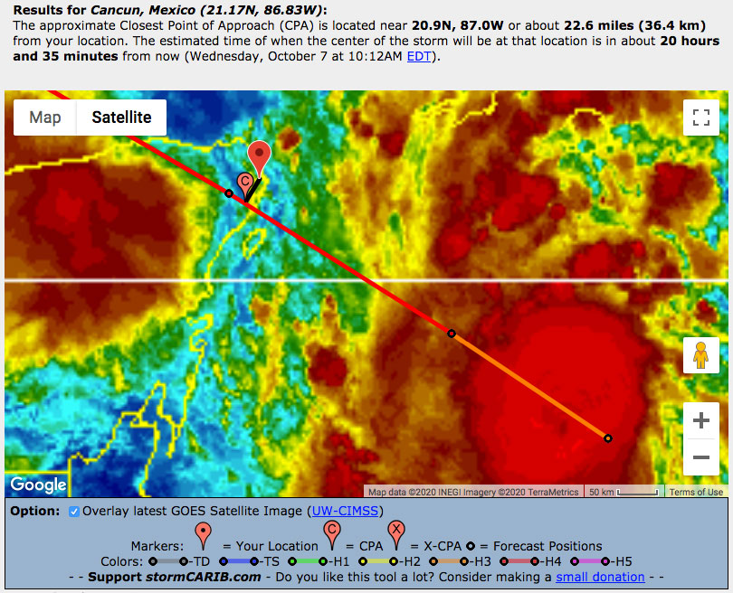 |
| - - - Closest Point of Approach Delta <-> Cancun (11AM advisories) - - - |
Monday, October 5, 2020 16:42PM EDT
- Gamma, Delta and who else?
-
Good afternoon!Â
Thank you again for all the well wishes but I think I have been letting Gert have all the fun or making more work for him and I can't let that happen! lol
Gamma the Pretender is spinning slowly down while moving even slower as it continues to drench the Yucatan Peninsula and the Mexican states of Campeche and Tabasco. Presently inching its way SW at a paltry 4 mph, Gamma will not be a threat to the US or anyone else but this slow movement will be agonizing to the residents of the NW Yucatan dumping copious amounts of rain causing flash flooding, mudslides and potential fatalities. Currently loitering offshore, Gamma is expected to make landfall tomorrow morning early afternoon and become an afterthought by Friday. Interestingly, there is a small chance that Delta will absorb Gamma if Gamma doesn't make landfall quick enough. Might slow Delta down for a bit.Â
Dangerous Delta. What does she have in store for Jamaica, the Caymans, Cuba, the Yucatan again, and the Gulf of Mexico? Obviously, her intentions are not good, especially where this year's hands down winner of the hurricane magnet award resides: the central Gulf Coast states of Louisiana, Mississippi, Alabama and the panhandle of Florida already battered and flooded by hurricanes Laura and Sally, so far.
Why dangerous already and only a tropical storm right now? Deltas potential down the road. That potential is called Rapid Intensification. Headed into an area of lower than 10 mph windshear, 86 degree waters, and a moist 70%ish atmosphere, TS Delta is going on a blind date with three characters whose combined effects or lack thereof, are ripe for RI. This poses issues for forecasting strength at landfall down the road. Now the waters in the GOM are not as ripe since several storms have already sucked up some energy off the sea surface while a cold front has pushed some cooler air across the northern Gulf. So, the faster Delta can strengthen taking advantageÂof her dates, the stronger she will be entering the Gulf where it will take longer for her to wind down a bit, especially since wind shear should rise and have a detrimental effect. While a Cat 4 is a distinct possibility butÂunlikely, Cat 3, a major, is very possible with weakening to a still volatile Cat 2 at landfall. Most events this year have been strengthening on approach so this will be a silver lining effect if this indeed occurs. Either way forward momentum will drive storm surge, coastal flooding, heavy rains and wind damage.
With that in mind, Delta still has to shoot the gap between Cuba and the Yucatan. Most of the models show Delta doing just that as any interaction with land would slow intensification. This would be good for the GOM states but not so much for the land it interacts with beforehand as an intensifying storm. Moving away from giving Jamaica a good soaking, the Caymans are next and are under a TS warning however that may change to a hurricane warning soon. The Western tip of Cuba is already under a hurricane warning as of this writing. Hurricane Hunters are already in the storm and will continue to be until close to landfall in the US.Â
This post is right before the 5 pm update so I'm sure some of this will change but that'sÂhow it is at this moment.Â
Take care, stay safe, and prepare!
Dave
The next official
Sunday, October 4, 2020 14:08PM PDT - Twenty-six
- Hmmmm, and here is number Twenty-Six, formerly known as Invest 92L. Looking at the satellite images (see above) you could be surprised to know that the center is currently located about 90 miles south of Kingston, Jamaica. The bulk of the storms seems to be more south of the Hispaniola. The National Hurricane Center is expecting this storm to become Tropical Storm Delta withing the next 24 hours. It is currently moving towards the Cayman Islands, with the closest point of approach with Grand Cayman of only 23 miles in about 38 hours! Indeed, a tropical storm warning has been issued for the Cayman Islands. There is also a hurricane watch for parts of Cuba as well. It is indeed expected to become a hurricane, however it is still unclear when (hopefully not too soon!) and how strong it could get. Major threats short term will be widespread heavy rainfall given the large size of this storm, so not only in nearby Jamaica and the Cayman Islands and later Cuba but also Hispaniola (Haiti and Dominican Republic). It is expected to enter the Gulf of Mexico and then make landfall as a possible major hurricane in the US. -Gert
Friday, October 2, 2020 09:22AM PDT - Twenty-five
- And here we have Tropical Depression Twenty-five! It is currently about 200 miles 200 miles south of Yucatan Peninsula. On its current path it is expected to pass over Cozumel in about 30 hours (and just west of Cancun, see closest point of approach-calculator). The outer rain bands are actually already moving over Cozumel. Sea surface temperatures are very warm (30C/86F) and wind shear is low so the depression is expected to become Tropical Storm Gamma soon. However, since it is so close to land already it probably won't have time to become a hurricane (though not impossible of course, we have seen stranger things!). The storm is not moving that fast so it will unfortunately produce a lot of rainfall, not only close to the center, but all the way from Cuba to the Bay Islands.
Meanwhile it is October already, so below the climatology of storm origins for this month. From 1944-2019 209 storms formed in October, so on average close to 3 a year. In September that number is 381, or about 5/year. So less storms form in October compared to the peak-month of September, but it is not over yet. Also the area of where storms form is still widespread, though like #25 most form in the western Caribbean, but also Cape Verde season is not over yet. Stay safe everybody! -Gert
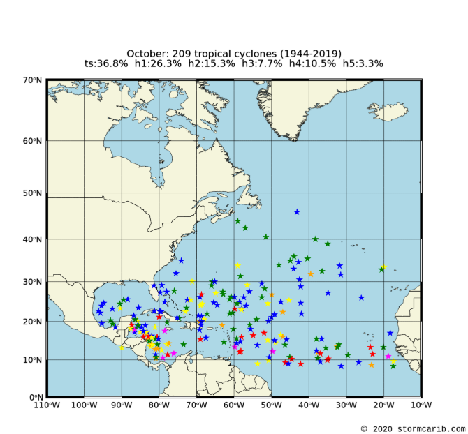 |
| - - - Tropical Storm Origins Climatology - - - |
Thursday, October 1, 2020 05:15AM EDT
- October
-
Good morning all,
Thank you for the congratulations and well wishes! Much appreciated!!!!
The lull in a frenetic 2020 season where we are already into the Greek alphabet is about to come to an end, quite possibly as soon as this weekend. A strong tropical wave is expected to develop into a depression and quite possibly more, close to the Cayman Islands and the Yucatan Peninsula. SST's are plenty warm enough to fuel the engine that could become our next named system, Gamma. Wind shear and Saharan dust will be limited as well. Where it tracks is still uncertain as well but it appears at the moment, it will go over the Yucatan and approach southern Mexico. Belize and the western end of Cuba are in the mix as well while heavy rain will affect South and Central Florida come late weekend as moisture from the Atlantic is drawn into the Caribbean and Gulf of Mexico.Â
Off just east of the Lesser Antilles island chain is a pretty vigorous wave as well producing quite the lightning show while bringing some much needed rain to some pretty dry islands. While it is not going to develop anytime in the next day or two, it is possible it will get it's act together in the central or western Caribbean down the road. Some models, 10 days down the road, are hinting at a west coast Florida hurricane. Keep your eyes on this one.
Keep your eyes also farther east as October is notoriously fickle and we have several tropical waves about to fall off the coast of Africa in the next few weeks with potential. The second peak of hurricane season is close at hand and your guard should still be on high alert.
That's it for the moment. Happy Thursday!
Dave
Tuesday, September 22, 2020 11:26AM PDT - Congratulations
- First, on behalf of the whole Caribbean Hurricane Network team, congratulations SuperDave and Melody on your wedding! We wish you a happy and fun life together, without any big storms!
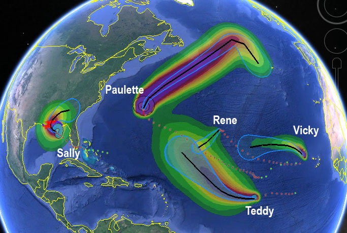
In spite of 3 active storms, indeed, as Dave wrote yesterday, things are quiet for us! Bermuda did well when Teddy passed by, Paulette (Bermuda's visitor from last week) reappeared south of the Azores is weakening right now. However, Beta is still drenching the Gulf Coast and Teddy is on its way to Nova Scotia where it will according to the advisories bring 'destructive waves, heavy rain and strong winds'. Hopefully this was 'it' for the season! -Gert
Monday, September 21, 2020 09:52AM EDT
- Slowing down a bit?
-
Good morning all!
The top story this morning is I got married to the most beautiful woman, the love of my life, Melody Beers on Saturday in South Waverly village, Sayre Pa. Thats why I've been MIA the last few days and Gert has posted regularly to keep you informed. Thank you Gert!! Now back to our regularly scheduled programming! lol
Things have quieted down from the last two weeks mayhem in the Atlantic and the Gulf of Mexico however, there are still menacing threats in each arena. The only real quiet area is the Caribbean itself, for now.
Hurricane Teddy: Still not playing nice but up till now was only a threat to the fishes and shipping. Now on a brush by course to Bermuda, which was already blasted by Hurricane Paulette, Teddy has been producing massive waves as a Cat 2 hurricane, down from a major hurricane just a short while ago. Teddy, on its blow by will produce tropical storm conditions but will be nothing like hurricane Paulette's bashing. Most in Bermuda have provisions left and have also left their properties boarded up so Teddy's island impacts should be minimal with the exception of the shoreline beating. The US east coast will also be impacted by Teddy trek north with swells and rip current risks from Nova Scotia to Florida. Speaking of Nova Scotia, TS warnings are up for them as Teddy is still forecast to be a 45mph TS upon arrival.
TS Beta: Yes we dipped into the Greek alphabet. How far is yet to be determined. Zeta in 2005 was the farthest previously. I feel we will go a bit farther this year. Small Beta is supposed to make landfall around 1 am this morning as a weakened TS somewhere btw Port O'Connor and Galveston as a 50mph storm. Making a right turn Clyde move, Beta's main threats will be storm surge and heavy rains in Texas and Louisiana as it slogs along slowly towards its demise in Mississippi on Friday. Sadly, this will also drop drenching rains on areas devastated by Hurricane Sally.
Wilfred: Has dissipated in the MDR (Main Development Region) and is not expected to regenerate.
Post tropical cyclone Paulette: The Phoenix may arise yet as Paulette, formerly a formidable hurricane which ravaged Bermuda, has done a loop de loop and is now heading east about 10-15 mph with a 60% chance of regeneration! Time will tell with potential tracks unsure depending upon its potential resurrection.
Tropical waves are still dropping off the coast of Africa and the way this year has been all around, be prepared for more activity as we head into October and November.
Be safe all and stay prepared!
Dave
Sunday, September 20, 2020 14:22PM PDT - Finally going north!
- It is great to have these excellent forecast models, otherwise we would have seen the monster storm Teddy going straight for Bermuda. And it was until just recently. After doing another little wobble to the west it is finally turning north. I know, the models told us so, but still, I have to actually see it before I believe it!
Teddy has weakened to a Category 2 storm, packing 105 mph winds, because it is following Paulette's path from last week, which has cooled the ocean. It doesn't look as scary any more as yesterday, however, it is a large storm. Even though the closest point of approach with Bermuda is about 110 miles, the island will still feel tropical storm winds, starting later tonight.
Elsewhere... Wilfred is doing what it is supposed to be doing... now barely a tropical depression. On the other hand Beta is still threatening the Gulf Coast. This slow moving storm is expected to dump a foot or more locally in Texas and Louisiana. Stay safe everybody! -Gert
Saturday, September 19, 2020 13:19PM PDT - Teddy <--> Bermuda
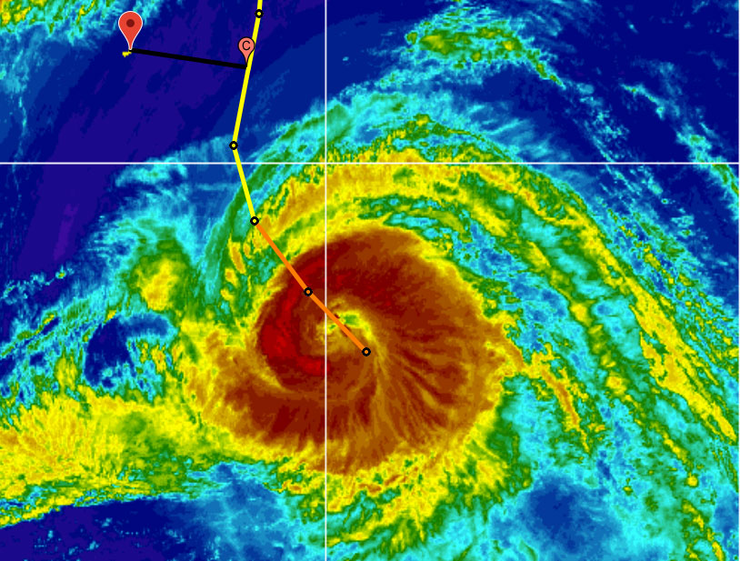
- There are currently four storms. Yesterday being a unbelievable day with three storms being named and thereby running out of names! Teddy is now a Category 3 storm. It is a formidable storm, as can be seen from the picture below, showing the closest point of approach with Bermuda. The CPA has increased again to 170 miles and will be reached Monday around 6AM. Although hurricane force winds extend outward up to 60 miles, tropical storm force extend outward up to 230 miles, so right now well within the 170 miles of the closest point of approach with Bermuda. The windfield also should increase more on Sunday, so Bermuda should expect tropical storm force winds for sure. They had Paulette just last week (it feels a lot longer ago), with the eye moving over the island. This one should stay further away. But still, be prepared! 13:45PM update: after writing this, a new advisory came out. Teddy's eye did a little jog to the west (=closer to Bermuda). The CPA is now 140 miles...
Other storms... the forecast track of Wilfred has changed, and it is now heading towards the islands after all. However, it should fall apart and become 'just' a wave about 800 miles before it even gets there. Beta is still in the Gulf, it is only 'moving' at 2 mph, so will produce dangerous storm surge and a lot of rain. Alpha is falling apart over Portugal. And finally, not listed above, the low that was Paulette, might become Paulette again! It is currently south of the Azores and moving east (so not towards us). It has a medium chance of becoming a tropical storm again. Not sure how they are going to name the advisories for it, since the advisory storm number (2) is currently taken by Beta (the NHC rotates the advisory numbers over 5 storms, for example the public advisory is named WTNT32, where the '2' denotes the storm number, and only the numbers 1-5 are used). Not my worry, they will figure it out. OK, stay safe everyone! -Gert
Friday, September 18, 2020 09:38AM PDT - Last one...
- Today we ran out of storm names, second time ever. Unfortunately this doesn't mean that nature thinks it is enough as well for this season. Now we are going to dip into the Greek alphabet, which might be later today... [actually as I write this, Alpha was just announced]
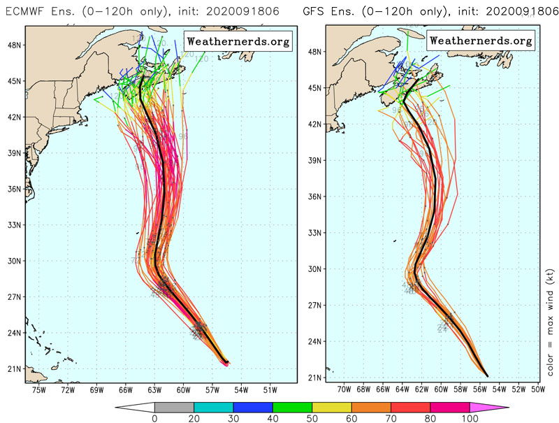
First our biggest threat, Teddy, now a Category Four Hurricane! It is still heading straight towards Bermuda. However, a turn is still expected before reaching The Rock. The forecasted track has trended a bit to the east again, with the closest point of approach now at 130 miles (yesterday it was 75 miles) early Monday. Indeed, looking at the European and American ensemble model output (see below, adapted from weathernerds.org), we can at least now see the little speck that is Bermuda outside the different model run tracks. However, the storm is still 2+ days away, so things can still change,it is still too close for comfort. Better be prepared than sorry when dealing with a major hurricane! Also, Teddy is producing large swells that can reach the islands. So it might be a good time to go boogie boarding, but be careful!
Elsewhere, the tropical wave we were following (98L) is now Wilfred, the last name on the official list. It still should move north of the islands, and even if it doesn't it looks like it will have weakened into a tropical wave before it even gets here.
Then we have Tropical Depression Twenty-Two in the Gulf of Mexico. That might become a hurricane, but the biggest threat will be the rain. It is a very slow mover, especially later in the forecast when it moves along the coast of Texas... Expect widespread flooding again...
Finally, about 3500 miles away we have Subtropical Storm Alpha, off the coast of Portugal (yes, that country in Europe!). It is expected to be short lived Looking at the storm tracks in my climatology-section, it seems not to be the first time that Portugal gets hit, but it is a rare occasion. Stay safe everybody! (and sssshhhhhtttt, tomorrow is going to be a special day for a special person). -Gert
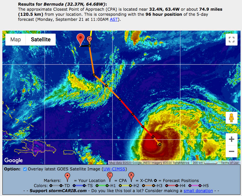
Thursday, September 17, 2020 09:54AM PDT - Teddy-Bermuda
- Ugh, that satellite picture above looks scary! Teddy is now a major Category 3 hurricane, packing 120 mph winds. It is expected to further strengthen... And right now it is moving straight towards Bermuda. However, a weather system coming off the United States in a few days should curve Teddy more to the north. The timing of that turn is crucial for Bermuda. Right now both the European ECMWF and American GFS model predict that Teddy will pass just east of Bermuda. See image below adapted from weathernerds.org, with the pink arrow pointing to the little speck that is "The Rock". Indeed, the closest point of approach is now 75 miles to the east on Monday (see below). Hope the trend continues driving Teddy more to the east... Regardless, people on Bermuda should get prepared for another hit, this one will be stronger than Paulette, but hopefully further away...
Elsewhere, Sally is still drenching the US but is rapidly weakening. Invest 98L looks to follow Teddy's path, so moving nicely north of the islands (hopefully not again towards Bermuda!). Stay safe everybody! -Gert
Wednesday, September 16, 2020 10:20AM EDT
- Sally and others
-
Good morning!Â
It's a busy morning again so let's get to it.
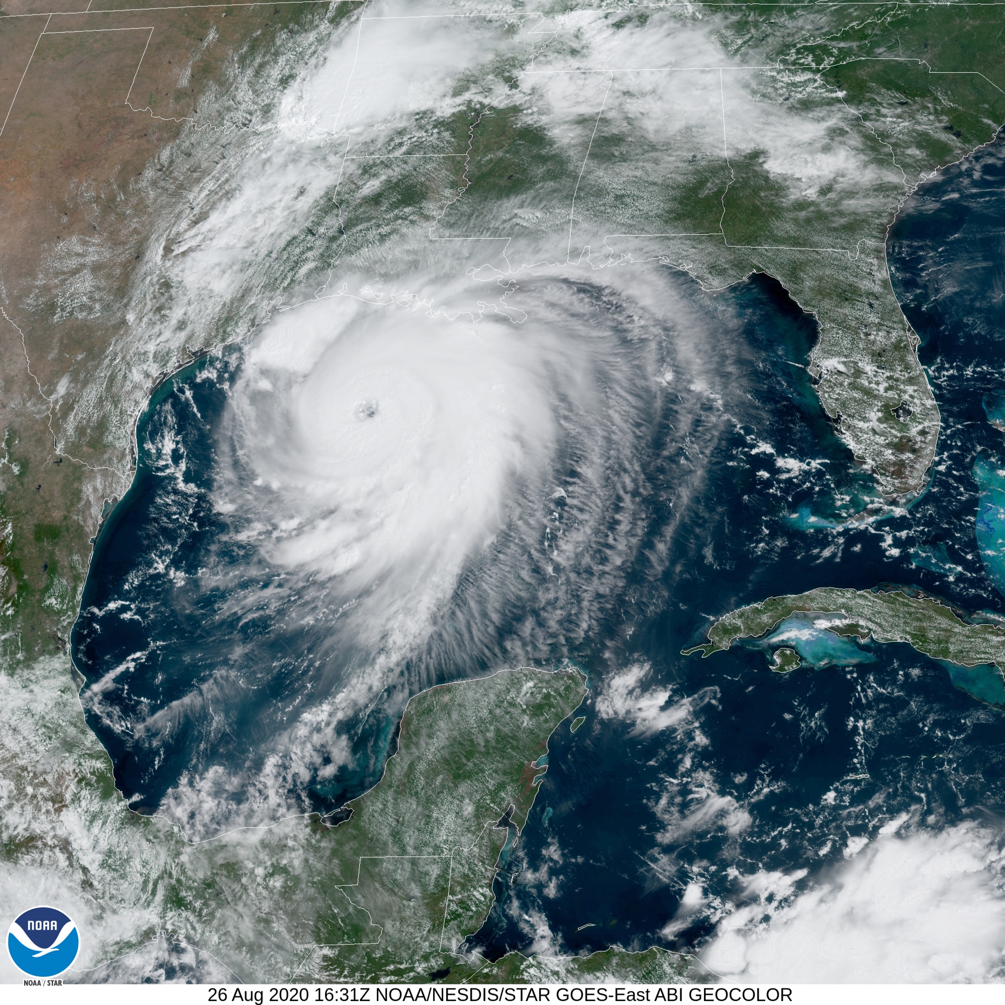
Hurricane Sally: Landfalling as I write. The northern eyewall has made landfall around Mobile Bay while Gulf Shores AL will become the official landfall. Gulf Shores and Pensacola FL are feeling the brunt of the eastern side with up to 30 inches of rain falling already with more to come while a dangerous storm surge still has a way to go, 5.5 ft in Pensacola so far. Hurricane force winds are already spreading inland. With 90 mph sustained winds gusting to 110 mph, Sally is expected to weaken rapidly while her forward motion is not so much at 3 mph. It means a prolonged pounding wind wise and rain wise and this will be, in the end, a catastrophicÂand historic event weather wise. She arrived as a strong Cat 2 and is now a strong Cat 1. Those who did not evacuate have made many distress calls but conditions are too dangerous for first responders. In their defense, which I usually do not defend people who do not evacuate when told to, this storm shifted east pretty quickly so close to the coastline that they really didn't have time to evacuate. Mother Nature threw a curve ballÂstarting towards southern LA and even potentially farther west, then curved in over the plate of Alabama instead. Sally will remain dangerous for the next few days. All that rain that falls to the north has to go somewhere. The surge and southerly winds are not allowing the rains that have already fell to drain into the sea so flooding will be a longer lasting damaging issue.
Hurricane Teddy: Looking ominous off to the east of the Antilles and Caribbean, Teddy is expected to become a beast of a bear; not the fluffy cuddly kind we are used to with a name like Teddy. Teddy is going to grow up rapidly and a Category 4 monster is expected within the next 36-48 hours due to low wind shear, no dust interference, and warm SST's. Fortunately, it should avoid the islands of the Antilles but due to a westward shift in the track courtesy of a stronger high pressure steering current, Bermuda, once again may be in the bullseye after being beat up by hurricane Paulette. Colder waters and increasing wind shear should knock Teddy down to a Cat 2 or Cat 1 by that time but still, 2 in a row.
Hurricane Paulette: After ravaging Bermuda, Paulette is now transitioning to a strong extra tropical storm with still potent 100 mph winds but a threat now to only the fish and shipping lanes. Even by Monday she is expected to still be at tropical storm force but no further threats expected.
TS Vicky: Located NW of the Cabo Varde Islands, packing 50 mph winds, she is affecting only the fish and shipping while expected to become a remnant low by or on Friday.Â
99L: Located a few hundred miles to the NE of the Azores, a non tropical system has a 20% of acquiringÂat least subtropical characteristics while moving south and east. No threat at this time nor projected to be.Â
There is an area of interest not assigned a number yet in the SW Gulf of Mexico that has an opportunityÂto become at least a TD during the next few days. Regardless, heavy rains will affect the Mexican coast.
98L: The one we in the Caribbean should be wary of for now. Moving west at 10-15 mph, conditions look good ahead for the formation of a tropical depression and with the strong steering high pressure system to the north, lack of dust and warm SST's this could be a problem in the Caribbean in 7-10 days. Time will tell.
Stay safe and prepared!!
Dave
Tuesday, September 15, 2020 14:24PM PDT - Teddy-Bermuda
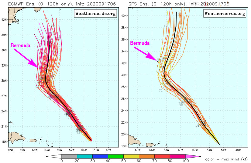
- Forgot to discuss Teddy's threat to Bermuda..., so looking at both the American GFS and European ECMWF model it looks like Teddy will turn more to the north in about 5 days, just before reaching Bermuda. So right now it looks like Teddy will bypass Bermuda. See this excellent excellent webpage showing the two model ensemble runs at weathernerds.org. Bermuda is the little speck at about 32.4N, 64.7W. Still awhile to go, but still, it is looking hopeful. -Gert
Tuesday, September 15, 2020 10:55AM PDT - Four storms, two invests
- Still busy out there, one less storm at least with Rene degenerating into a tropical wave. Sally is currently the headliner, moving slowly towards the Gulf Coast. This is never a good thing. At least it is not expected to strengthen much. It is encountering some wind shear and also it is stirring up the water column, bringing cooler water to the surface. Storm surge, esp. in Mobile Bay will be severe, esp. if the storm stays just to the left (west) of Mobile. And of course a slow moving storm has a lot of time to drop buckets and buckets of rain. The advisories call for locally 30 inches (76 cm!) of rain! So again, if you are under an evacuation order, then leave! No excuses. More lives are lost in a hurricane due to water than wind.
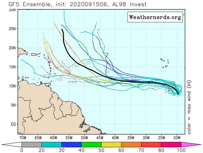
Teddy is behaving as it should, staying about 500 miles away from the islands. Which is a good thing since it is expected to become a major hurricane! The only feature currently of interest to us is the wave that came off Africa, invest 98L. It is still a long way away of course, but looking at the GFS ensemble forecast it will move west for awhile, before turning north, see image below adapted from weathernerds.org. Hope that holds true. However, there are some 'outliers' that take it very close to the islands, and also pay attention to the color of those lines, it might become a strong hurricane. Still a week away, and models have a hard time dealing with poorly defined storms, so a lot can/will change, as we saw with the previous one (now Teddy). Stay tuned and all the best to the people threatened by Sally! -Gert
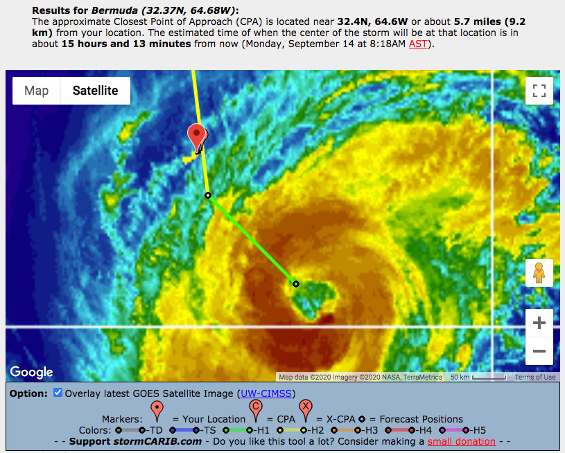
Monday, September 14, 2020 09:16AM PDT - Hurricane Paulette, Tropical Depression Rene, Hurricane Sally, Tropical Storm Teddy, Tropical Storm Vicky
- I thought my list from the other day was long..., but now we have 5 named storms. See graphic below. Unprecedented? It apparently happened one time before, in 1971... Paulette is moving away from Bermuda, but they are still in one of those strong feeder bands. In case you missed it, this from the 3AM AST advisory:
Hurricane Paulette Tropical Cyclone Update
NWS National Hurricane Center Miami FL       AL172020
600 AM AST Mon Sep 14 2020

...ALL OF BERMUDA STILL IN THE EYE OF PAULETTE...
...STRONG DAMAGING WINDS AND TORRENTIAL RAINS WILL SOON AFFECT
BERMUDA FROM THE SOUTHWEST...
At that time Paulette was a strong Category 1 hurricane, strengthening into a Category 2. I am trying to get some reports, but I can imagine that the power is out and people have something else to worry about. That something else might come next week... Right now it looks like Teddy (was Twenty) is aiming for Bermuda, and this time it might be a stronger storm than Paulette. It is still far away, so a lot can/will change, but maybe don't store away those hurricane shutters yet...
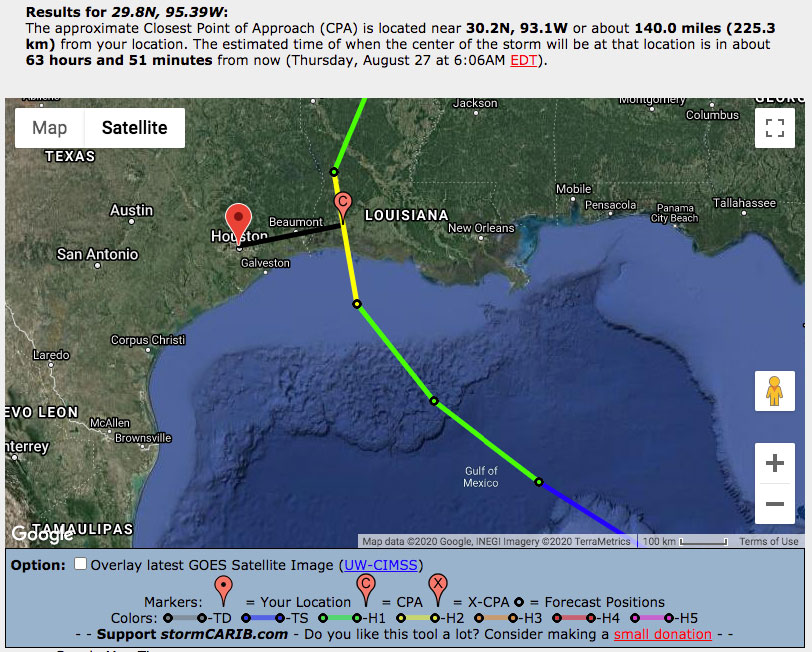
In the meantime, the Gulf Coast is getting ready for Sally's landfall, which is now officially a hurricane and it is still strengthening. It is close to the shore, but unfortunately moving relatively slowly at only 6 mph. So it still has some time to strengthen..., also, slow moving storms are notorious for widespread flooding. Also, as you can see from the second image below, it will continuously push water towards the coast, causing major storm surge. I marked the forecast positions with 1 day, 2 day, etc., so you can see long it will stay in the area... Please if you live in the affected area, read the advisories closely, esp. the Hazards Affecting Land section and get out of there!
The other two storms on the list don't pose a threat to us. Yay! Stay safe everybody! -Gert
 |
| - - - Sally battering the Gulf Coast [see CPA tool] - - - |
Sunday, September 13, 2020 06:34AM EDT
- Land and Sea
-
Good morning!
Running late writing some posts as my computer died and my new one not available for another week or so. But here I am and here we go:
Hurricane Paulette: On a beeline for Bermuda expecting to arrive early Monday as a strong Category 2 with a flirt at Cat 3 status. Slight dry air intrusions will slow that intensification but she will be able to fight them off while wind shear will drop to very low levels. Heavy seas, dangerous storm surge, strong winds, and heavy rainfall are expected. Swells from Paulette will affect the Greater Antilles, Leeward Islands, east coast of the US and the Bahamas inducing dangerous rip currents. On approach to Bermuda, Paulette is expected to slow down a bit but also still be on a strengthening trend which will enhance the impacts. Cat 3 is definitely a possibility actually after impact and passing. Bermuda is well fortified from these tropical attacks however not immune. Hurricane Hunters are expected to investigate later today.
TD Rene: Holding on for dear life in the central Atlantic. About 1160 miles ENE of the Lesser Antilles, Rene is expected to go poof Monday or Tuesday and become a remnant low pressure system while changingÂdirections from the NW to the WSW. A fish storm and no threat to land. Regeneration is not expected as well.
TD#20: Located about 1735 miles east of the Lesser Antilles while moving at a paltry 10 miles an hour to the WNW, TD#20 is expected to become a hurricane reaching Cat 1 on Tuesday and Cat 2 on Thursday. The good news is this soon to be a bear of a storm, Hurricane Teddy, will be hugging fishes and not landmasses. He will continue on a WNW track then turn more northward into the central Atlantic in reaction to a weakness in the ridge to the north.
Hurricane Sally: The majority of the models are in agreement on a strengthening, land falling Cat 2 hurricane around Grand Isle, La and the mouth of the Mississippi river on Tuesday morning. Slowing down on approach will enhance tremendous rainfall, flooding and very dangerous, life threatening storm surge. Northerly wind shear has affected the storm, now about 125 miles west of Port Charlotte, Fl and assisted in keeping intensification from ramping up but that is expected to lighten up. The chances of rapid intensification are possible but that depends on how strong Sally can consolidate over the next couple days. Waters are definitely warm enough. The Florida Keys took a wallop as Sally passed by as did the southwestern portion of Florida and were lucky that northerly shear was present. Depending on some ridging that has formed to the north, landfall farther to the west cannot be ruled out which will not be good for the area ravaged by Hurricane Laura.Â
97L: Giving the Cabo Verde Islands some rain and gusty winds, it is expected to head WNW to NW and another fish storm is imminent. No threat to the Caribbean.
There's more to come in the weeks ahead, so preparations should haveÂbeen done already and vigilance continued as we look warily to the east and it's rapid fire tropical wave production.
Stay safe and prepared!
Dave
Saturday, September 12, 2020 14:00PM PDT - Paulette, Rene, Sally, Twenty and 97L Invest
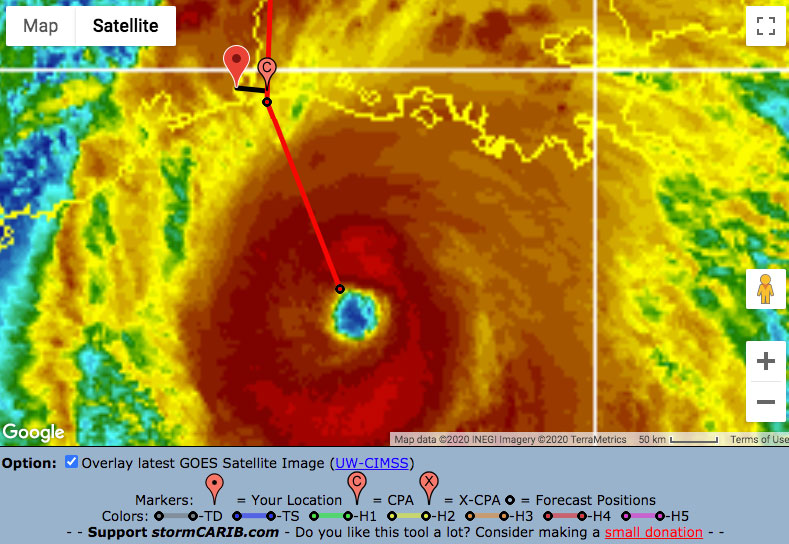
- Wow, a long list, four storms plus one invest, of which Paulette is our only worry. Paulette's official closest point of approach is only 1.2 miles, which is relative to the airport on the eastern side of the island, so basically we are looking at a direct hit Monday morning. At that time Paulette is still forecasted to be a category 2 hurricane with 100 mph winds... Bermuda is under a hurricane warning and things will start going downhill Sunday evening. Normally Bermuda is pretty well equipped to deal with storms, so let's hope that holds true this time around as well. On the right you can find the link to the Bermuda updates from our local hurricane correspondents.
Newly tropical depression 20 is what we had been calling future Sally, but tropical depression 19 currently near Florida beat it to it. TD 20 is expected to become Tropical Storm Teddy soon, and then we only have Vicky and Wilfred left before we start the Greek alphabet. Now it looks more and more likely that the storm won't reach us, but that it will curve north well before it reaches the islands. Below images shows the forecast tracks of all the storms, incl. Invest 97L. This is the 6 day time point of the European Ensemble model (adapted from weathernerds.org). So some good news! -Gert
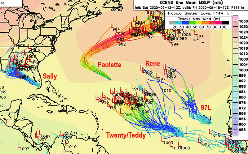 |
| ECMWF Ensemble Model Run (ECENS), valid next Friday [adapted from weathernerds.org] |
Friday, September 11, 2020 13:55PM PDT - Another day, another model run
- But first, Paulette... This storm is looking more and more threatening for Bermuda. Right now the closest point of approach is only 26 miles on Monday. At that time Paulette is expected to be a Category 2 hurricane, so indeed, something to prepare for. Right now the center is expected to pass to the west of the island (earlier it was to the east). This means that the strongest side will go over Bermuda... Check out the reports from the local hurricane correspondents on Bermuda as they come in.
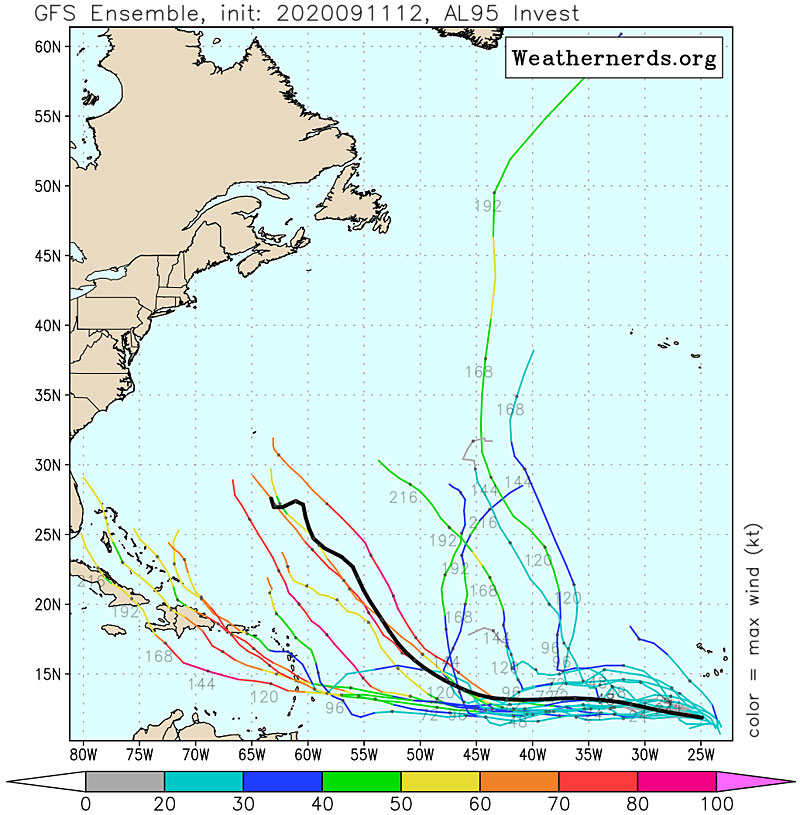
The wave we have been talking about for awhile now just below the Cape Verde's, has been 'upgraded' to Invest 95L. The new model runs paint a different picture compared to yesterday. Some good news, some bad news. The good thing is that it now seems more likely that it will curve north before reaching us. See the GFS Ensemble Run below (adapted from weathernerds.org). The European ECMWF model is showing a similar picture. However, you can see that some of the model runs in the ensemble have the storm move through the islands as a hurricane, so not a weak tropical storm as I wrote yesterday. It is still 4+ days out, but we will be closely watching this one!
The other invest you see in the tools section above, 96L will travel over Florida into the Gulf of Mexico, so of no direct concern to us. Right now it doesn't look like it will be a strong storm, but with the warm Gulf waters you never know... -Gert
Thursday, September 10, 2020 11:12AM PDT - Hurricane (?) Paulette aiming for Bermuda...
- I didn't expect to discuss Paulette again, but it might actually hit Bermuda as a hurricane! Although still a tropical storm, conditions are expected to become more favorable in a few days, less wind shear and plenty warm sea surface temperatures. Right now the closest point of approach with Bermuda is only 18 miles (see image below). It is still about 5 days away, so for sure a lot can change, but just a heads up! Also, Paulette might cause some nice swell for the islands. Get your boogie board out!
There has been a lot of talk already about the wave about to emerge from the African coast. Most like our future Sally. Indeed, models are still forecasting it to track a more westerly route than Paulette and Rene. For example the European ECMWF model takes it close to the islands next Wednesday (see second image below, edited from tropicaltidbits.com). However, it doesn't seem to become a 'big one'. The image below shows the Low at the 144 forecast hour (6 days) of Thursday's ECMWF model run. The central pressure shows 1008 mbar, which translates to a wind speed of about 40 mph, so barely a tropical storm. Six days is of course a long time to go, a lot will change, so be prepared but don't start panicking yet! -Gert
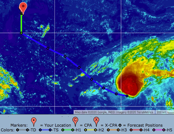 |
| - - - Paulette closest point of approach with Bermuda - - - |
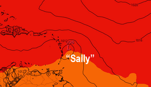 |
- - - "Sally" near the islands - - -
144 forecast hour ECMWF Model |
Wednesday, September 9, 2020 18:59PM EDT
- September
-
Good evening!
Talk about busy. But not catastrophic. TS Paulette and TS Rene , seemingly benign, will be nothing but a good date in the middle of the Atlantic ocean as "fish storms" destined to menace shipping lanes, fishing boats, and other oddities. But, no land masses at this moment.
That is not the case for 94L which should acquireÂthe name Sally and "ride" into the NC/SC border as a medium TS in the next 36-60 hours. If it does not acquireÂa name, the wave which hasn't even left land off the coast of Africa, will definitelyÂtake its place.Â
That one and the one behind it looks to be ominous and long term trakkers. Cape Verde classics. Not a good scenario. Tomorrow is the historical height date of the Atlantic hurricane season. We still have over 60% of the season to go and with that comes bad memories, Please be prepared if you haven't.Â
Dave
Tuesday, September 8, 2020 14:46PM PDT - Sally?
- Paulette and Rene are behaving as expected and are passing nicely north of us. If Paulette continues on as is, it might pose a threat to Bermuda, but still, it would be just a tropical storm. Easy peasy for Bermuda.
Just a heads up..., the next wave coming off the African coast, which is expected to become Sally, might not follow the same path as these storms. Looking at some model runs it does stay on a westerly course and might reach the islands next week. The same for the wave after it... This is all of course still very uncertain, so no need to board up yet :-), but we are in the peak of hurricane season and need to stay focused of what is ahead. -Gert
Monday, September 7, 2020 10:50AM PDT - 17+18
- And here we have number 17 and 18, with #17 already upgraded to Tropical Storm Paulette. Another record for the earliest 'P' storm, broken by 10 days nonetheless! Paulette located about 1300 miles to the east of us, is a slow mover, and struggling with some wind shear and dry air. As of now Paulette is not expected to become a hurricane, and even better, it should pass well north of the islands.
Number 18 formed east of the Cape Verde, yes, indeed, east, to the right! Between the African coast and the Cape Verde islands, so it was classified pretty quickly after it moved off the African coast. It is expected to become Tropical Storm Rene soon, indeed, tropical storm warnings have already been posted for the islands. This one is expected to become a hurricane in the next three days or so, but just like Paulette it should pass well north of us, if it ever reaches our longitude.
Elsewhere, not much going on that could affect us, except for another tropical wave expected to move off the African coast later this week. Enjoy your Monday! -Gert
Saturday, September 5, 2020 11:33AM PDT - Correction
- I mis-identified the 2nd storm in the image. That is not the wave expected to leave the African Coast on Sunday, but the one after that. The wave coming off soon is also expected to move north and will stay pretty weak, esp. compared to the one I am showing in the image. In any case, as it looks right now, none of these pose a threat to the islands. -Gert
Saturday, September 5, 2020 10:33AM PDT - 25 years ago
- Twenty five years ago Hurricane Luis hit the Leeward Islands. It was devastating for the islands, esp. Barbuda, St.Martin and Anguilla. The effects were amplified because the islands had not experienced a 'big one' since 1950. Luis was the storm that was the impetus for this website. The logo also depicts Luis. It was a very stressful time...
Meanwhile, a tropical wave in the far Atlantic will be the next candidate for the 'P' storm. Looking at the spaghetti plots of 92L above it is most likely that the storm will curve to the north before it reaches the islands.
Another tropical wave south of Puerto Rico is not expected to become anything. However, another wave still over Africa will be the next one to watch. Below a snapshot of the ECMWF Model Forecast for next Saturday 0:00UTC, indeed showing 92L passing north of the islands, and the wave currently over Africa pretty far south. However, as of now, the ECMWF model indicates that this wave will turn north as well. Hope this all holds true! Stay safe! -Gert
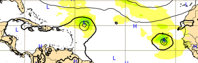 |
| - - - ECMWF Model Snapshot 9/12/20 0:00UTC - - - |
Wednesday, September 2, 2020 11:19AM EDT
- Nana, Omar and hmmmm
-
Good morning from Miami airport,
TS Nana is now making a beeline for Belize City while raking the northern coast of Honduras along the way. She will not be the nice grandmotherly type Nana we all love and know as she is making a bid for hurricane status which should happen later today due to her improved structure plus the appearance of a small CDO or eye like feature. The shape of the coastline heading into Belize may have assisted with that improvement as well as the very warm SST's and lack of significant wind shear. Belize, Guatemala, and southern Mexico are going to be in for heavy rains, flooding, mud and landslides, with storm surge also crashing into Belize and their beautiful reefs, While only a minimal hurricane at landfall, this will have devastating effects in those areas. Then after traversing that area of Central America, it's possible she could regenerate in the East Pacific!
TS Omar is nothing like his uncle was in the Caribbean and is due to fizzle out NE of Bermuda as a fish storm. It's hard to imagine why this system was designated a named storm in the first place but it met the minimum criteria at the time even though it was one of the raggiest TS's we've seen.Â
Off to the east of the islands, we have several waves of interest with the most interest being paid to one which just splashed down off the African coast and will be a player at some point down the road. Given a 60% chance of developing in the next 5 days, this could be a long track Cape Verde storm with evil intentions, especially due to the steering current by the high pressure to the north and lack of Saharan Dust in it's way.Â
91L in the middle of the MDR looks discombobulated and appears to be a fish storm in the end but the fat lady hasn't sung on that one just as yet. We have all been fooled before and any wave that comes off the coast of Africa from mid August to mid October needs vigilance.Â
Off to my flight. Be safe and prepared!!
Dave
Tuesday, September 1, 2020 10:59AM PDT - Nana
- Tropical depression 16 in the Caribbean Sea was upgraded to Tropical Storm Nana. It is currently about 110 miles south of Jamaica and 650 miles east of Belize City. On its almost due westward track, Nana is expected to pass about 180 miles south of Grand Cayman (closest point of approach reached tomorrow 9:30ish AM, see below). Currently it looks like the system is aiming for Belize. Tropical storm watches have been posted for Belize, northern Honduras, including Roatan and the Bay Islands. Indeed, right now it is expected to pass just 20 miles north of Roatan and Guanaja... Sea surface temperatures ahead are very warm, and it looks like Nana might develop into a hurricane before making landfall (Thursday), but not before reaching the Bay Islands... Hope that holds true..
Tropical depression 15 is moving away from the US coast, it might become Tropical Storm Omar, but is not threatening any (is)land.
Meanwhile it is September already (or just, looking at the number of storms we have had already). The month of the Cape Verde storms that we fear most. See below image taken from the climatology-section showing historical positions of storm origins (orange, red and purple stars became Cat 3, 4, or 5 storms resp.). Indeed, there is a wave coming off the African coast right now that has a good chance to develop into something... Stay safe everybody! -Gert
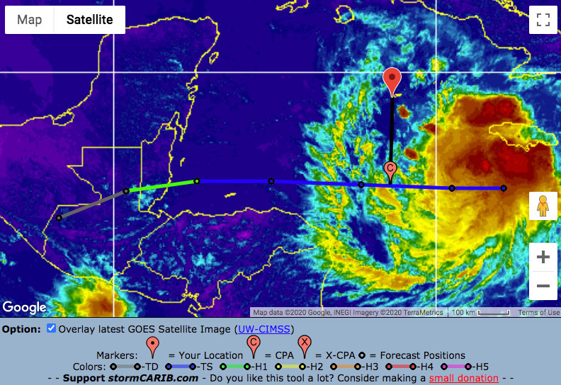 |
| - - - Nana's closest point of approach with Grand Cayman - - - |
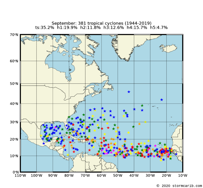 |
| - - - Storm Origins September - - - |
Monday, August 31, 2020 07:36AM EDT
- Heating up
-
Good morning all!
Hope you had a safe, well and fun weekend or at least relaxed while we had a short lull in the 2020 tropical season however, that is about to change this week so get ready for the next 6-8 week high activity ride. It's possible the Saharan Dust late season continuance might have a say in just how high though, in this September's activity.Â
Note: Good to see the normally arid Dutch Islands aka the ABC Islands received some much anticipated rain lately as they miss much of the year's tropical activity.
99L: Now located approx 15.5N 70.0W moving westward at a modest 15-20 mph, 99L is making a bid to become the next named storm which is Nana. Better organized on satellite review this morning, this system is forecast to continue it's westwardÂtrek through the Caribbean. Jamaica, the Caymans, Belize and the Yucatan Peninsula should all be on alert as well as Honduras and Guatemala.Â
90L: Off the coast of Florida, 90L has a chance to develop and also make a bid to beat 99L to the name Nana. If it doesn't, it will settle with the next name after, which is Omar. I remember hurricane Omar quite well in the US Virgin Islands in October 2008 which took a wrong way Lenny approach from the SW to the NE. Bermuda might be the only land interest in its development arena as it will be an OTS (out to sea) storm.Â
Waves: There are several of these in the MDR (Main development Region). One just about to fall off the African coast which has my attention and another SW of the Cabo Verde Islands which has development possibilities if it can escape the ITCZ and avoid interaction with our, friendly to us but not to tropical systems, that dry air Saharan Dust.Â
Be vigilant, stay safe and prepared!! Happy Monday!
Dave
Thursday, August 27, 2020 19:45PM EDT
- Next! And will we reach the Greek Alphabet?
-
Good evening!
This evening's post is more informational on the future, what to look forward to while being prepared for and not detailed as uncertainty rules the now.Â
While all eyes are now on TS Laura, who continues to bash the lower Mississippi Basin on her way to a right turn Clyde towards the east coast and a possible slight regeneration once off NY and PA to menace Boston and Newfoundland, activity in the MDR or Main Development Region of the Atlantic Basin is sneaking up on the Caribbean, east coast and Bermuda. Right on schedule.
A wave around 46W is moving towardsÂthe west around 15 mph and is expected to move through the central Windward islands; as what type of entity is unsure of at this time but development is obviouslyÂpossible. The wave behind it, located approximatelyÂ24W, is alsoÂmoving about 15 mph to the west. This one preliminarily is expected to pass north of the Leewards. North Carolina and Bermuda might want to watch this one. This one also has more model support for hurricane formation. Back on the African continent, the bowling alley is lined up to toss more wannabe named storms, one right after the other. This is going to be a busy next 6 weeks.
Saharan dust levels are still high to the north of these systems so there will be some disruption to slow any formation for now. However, these waves are paving a wet, moisture laden yellow brick road for the ones waiting in the wings. SST's are very sustainable for storm formation and wind shear is not as prevalent as it has been.Â
Nana is the next name and I believe she will not be the nice grandmotherly figure we all come to love and respect. There won't be many names left after that and then, we reach the Greek alphabet. It's happened before and we know history repeats itself.Â
So far the Eastern Caribbean has dodged a few early bullets but we all know luck will run out eventually. Stay safe, vigilant and prepared!
Dave
Wednesday, August 26, 2020 14:33PM PDT - Category 4
- Laura is now a Category 4. It's bands are starting to reach land. Below two images to reiterate the threat of the storm. The first one shows the Closest Point of Approach with Port Arthur, only 20 miles... The area to the east (right) will see the highest storm surge, which as I mentioned before will be 'unsurvivable'. The second image shows the area currently under a storm surge warning. Note that it goes about 40 miles inland! This is a Google Earth screenshot, using NHC's nhc.kmz feed. So again, if the local authorities tell you to get out, do it! Don't be foolish or stubborn. -Gert
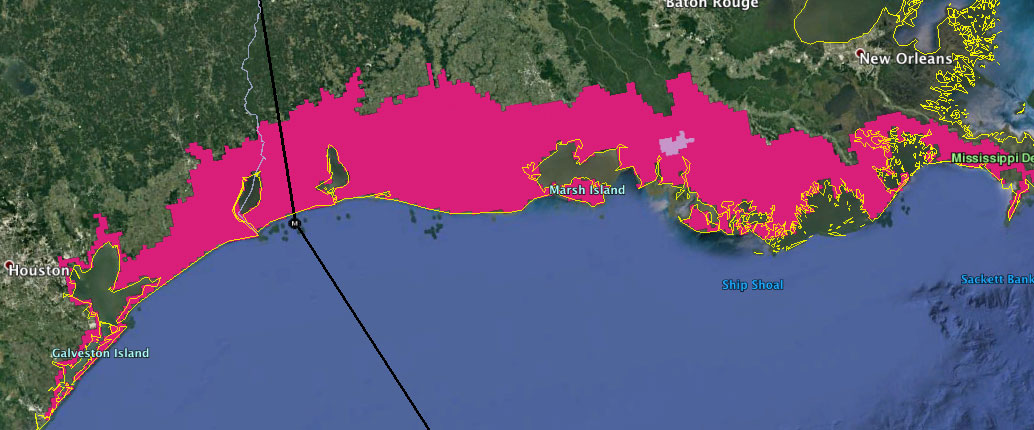 |
| - - - Area currenlty under Storm Surge Warning - - - |
Wednesday, August 26, 2020 09:29AM PDT - Category 3
- Laura is now a major hurricane and is expected to become a Category 4 later today. At landfall it hopefully has weakened to a Category 3 again due to wind shear. I will just reiterate the Key Messages from the NHC advisories:
     1. Unsurvivable storm surge with large and destructive waves will
     cause catastrophic damage from Sea Rim State Park, Texas, to
     Intracoastal City, Louisiana, including Calcasieu and Sabine Lakes.
     This surge could penetrate up to 30 miles inland from the immediate
     coastline. Only a few hours remain to protect life and property and
     all actions should be rushed to completion.

     2. Hurricane-force winds are expected tonight in portions of the
     hurricane warning area from San Luis Pass, Texas, to west of Morgan
     City, Louisiana, with catastrophic wind damage expected where
     Laura's eyewall makes landfall. Hurricane-force winds and
     widespread damaging wind gusts will spread well inland across
     portions of eastern Texas and western Louisiana early Thursday.

     3. Widespread flash flooding along small streams, urban areas, and
     roadways is expected to begin this afternoon into Thursday from far
     eastern Texas, across Louisiana and Arkansas.  This will also lead
     to minor to isolated moderate freshwater river flooding.  The heavy
     rainfall threat and localized flash and urban flooding potential
     will spread northeastward into the middle-Mississippi, lower Ohio
     and Tennessee Valleys Friday night and Saturday.
Below the latest satelllite image of Laura (modified from NOAA GOES Image Viewer), be safe everybody, don't do stupid things and don't think that you can outsmart this storm. Did you read the part about unsurvivable storm surge above? -Gert
 |
| - - - Laura approaching the Gulf Coast [click on image for full size] - - - |
Tuesday, August 25, 2020 08:43AM PDT - Houston (!?)
- Although we are the 'Caribbean' Hurricane Network, we still worry for everyone affected by hurricanes. The forecasted track is still trending westward, so what Dave and I have been trying to say for a while: Houston watch out. Also, Galveston, Port Arthur, Beaumont be prepared for a direct hit. And of course, cities further to the east, incl. New Orleans, you are not out of the woods yet. Read the advisories, check out the 'hazards affecting land', most people just think of the wind, which will be significant of course, esp. where the storm makes landfall, but many more people die of 'water' related causes. Storm surge will be severe, and Laura might make landfall at time of high tide. Rain, of course, don't focus on the eye, flooding will be widespread, and not only where the hurricane makes landfall. Use the tools above to assess the threat to you, including the Closest Point of Approach calculator, but again, a hurricane is not a point, there is an option to overlay it with the satellite image and then you will see! Below the most like arrival time of tropical storm force winds. Be prepared, and stay safe! -Gert
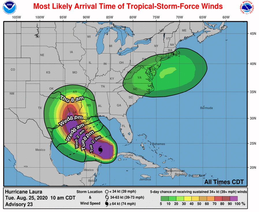 |
| - - - Laura Most likely arrival time (as of Tue 8/25 10AM) - - - |
Monday, August 24, 2020 18:15PM EDT
- Doomed Marco and Ruh Roh Laura
-
Good late afternoon!
High anxiety time in the Gulf of Mexico is the current state of affairs as we have 2 tropical systemsÂmaking a US landfall within a 3-4 day period, in almost the same area. TS Marco has pretty much left the building after brushing the Yucatan Peninsula of Mexico, then making a beeline for the mouth of the Mississippi Delta, and finally being ripped apart and exposed by wind shear leaving his center totallyÂexposed with all the convection to the north and northeast. This has spared Louisiana so far from severe impacts while the panhandle of Florida has taken the unexpected brunt of the storm.
Meanwhile, TS Laura has been quite the survivor, having impacted the northern Lesser Antilles islands, Puerto Rico, Hispaniola which includes the DR and Haiti,Jamaica, the Cayman Islands, now Cuba and eventually the northern central coast of the Gulf of Mexico later this week. Already deadly, Laura has not reached her full potential yet and will potentially become a fierce force of nature by Wednesday. Why?Â
After departing the Caribbean and entering the Gulf of Mexico, nirvana awaits this girl. A potential Cat 3 or even 4 intensifying on landfall, Laura is not a name synonymous with devastation but I believe she will be. Bath waters of up to 88 degrees in spots, limited wind shear which is departing the area after ravaging TS Marco, humidity moisturizing the mid levels, weak stirring currents and those warm bath waters reaching well below the surface are all coming together to potentially create a catastrophic, rapidly intensifying, landfalling major hurricane. The cone of uncertainty has a piece of Texas and almost all of Louisiana in its sights. I did share earlier, Houston, you have a problem. I am reiterating. Houston, you have a potential major problem. Especially with potential flooding, the port, the huge amount of petroleum assets and associated shipping located so close to the gulf along with your huge concrete jungle which cannot drain the humongous area of land to your north, east and west through your drainage canals in the megalopolis fast and efficiently enough.Â
Off to the east things are quiet for the moment. With the peak of season on the rise, it's no time for complacency. We haven't even reached that yet. Be prepared, always vigilant, and lookout for those less able to take care of themselves during a potential event. Prayers to those in the DR and Haiti who lost their family members. Sadly, I believe this is not the end of Laura's deadly affairs.
Stay safe, aware and prepared!!Â
Dave
Monday, August 24, 2020 11:06AM PDT - Laura
- The center of Laura is now just south of Cuba and about 140 miles north of Grand Cayman. It is causing a lot of rainfall in the area, including Jamaica. Laura is still 'just' a tropical storm, conditions are pretty good now for further strengthening if it wasn't so close to Cuba. Laura will cross western Cuba later today, and once it is in the Gulf of Mexico it is expected to become a hurricane. It is expected to make landfall late Wednesday/early Thursday somewhere between Houston and New Orleans. Although the official forecast calls for a Category 2 storm at that time, I would not be surprised if it strengthens into a major (Category 3 or higher) hurricane. So don't underestimate this storm. Also, Marco is going to travel over the same area today and tomorrow, so the ground will already be saturated by the rain..., expect widespread flooding... Heed the warnings of your local government, adhere to evacuation orders, etc. Everything is more complicated because of COVID-19, but everyone try to be safe! See below storm track and closest point of approach with Houston. -Gert
Sunday, August 23, 2020 10:21AM PDT - Haiti
- It looks like Laura is dealiing Haiti another devastating blow. Due to deforestation Haiti is very vulnerable to flooding, and indeed there are many reports of flooding already (see Haiti updates from the local hurricane correspondents). One death has been reported. Also, esp. worrying is that the Peligre Hydroelectric Dam reservoir (the tallest dam in Haiti) is full and might burst its banks. People downstream are urged to evacuate... As you can see from the screenshot below it is far from over..., although the center of Laura is moving away from Port au Prince. Hoping for the best. -Gert
 |
| - - - Closest point approach Laura - Port au Prince - - - |
Saturday, August 22, 2020 14:58PM PDT - Big change in Marco forecast
- For people in the path of Marco, be aware that the forecasted track has moved to the east significantly! It now shows Marco making landfall in Louisiana in two days. Very different from the plot I posted earlier this morning. Still lots of uncertainty, so everyone living near the coast in the Gulf states pay close attention to the progress of this storm. -Gert
Saturday, August 22, 2020 10:23AM PDT - Two storms
- And now we have Laura and Marco! It sounds like a broken record, but yes, these are the earliest L and M storms ever... The previous record was beaten by 11 days! Laura is getting a bit better organized as the center travels just south of Puerto Rico. But as you can see on the satellite image above they are getting a lot of rain. Laura's forecasted track is much more south than earlier thought, which is a good thing for Florida. Laura is forecast to move over Hispaniola (Dominican Republic and Haiti) which will prevent much further strengthening at least for now. Esp. in Haiti wet systems like these can cause a lot of problems though... Once it has crossed over Cuba it will have the space and warm water to strengthen into a hurricane. Right now it is expected to reach 'only' Category 1 status, but I wouldn't be surprised if it becomes a major one before making landfall.
More to the west we have Marco, luckily moving a bit more east then earlier forecasted. It is now passing about 75 miles to the east of Cancun, Mexico as a tropical storm. It will shortly move into the warm waters of the Gulf where it is also expected to strengthen, probably more quickly than Laura because of its smaller size. Right now NHC keeps it at a Category 1 as well, and even weakening to a tropical storm before making landfall because of increased wind shear.
So we will have 2 storms in the Gulf of Mexico starting Monday, see Google Earth image below. And they are expected to make landfall about one day apart. This means lots of precipitation in the Gulf states, probably causing much flooding... At least it looks like these storms are not going to stall but move out of the way at a normal pace. Stay safe everybody! -Gert
 |
| Laura and Marco converge |
Friday, August 21, 2020 09:02AM EDT
- TS Laura
-
Good morning all,Â
A quick update on my work break. TD#13 could and should be upgraded to TS Laura at the 11am NHC advisory as hurricane hunters have found a weak but closed circulation within the last hour. The center was fixed at 16.7N 59.51W or about 133 miles to the ENE of Guadeloupe at that time. Expect many watches to be upgraded as well to warnings. Not much change in impacts will be felt though. Squally winds and heavy rains with rough seas and probableÂflooding will occur. Fortunately, this system is still moving quickly which will mitigate it's effects as it passes close to the northern Lesser Antilles soÂno rapid intensification into a hurricane will occur inÂthis arena. Down the road, this story could change dramatically though as it moves towards the T&C and southern Bahamas. Florida should be very wary.
TD#14 has also been found to contain a weak circulation but is so large it still needs to stack and consolidate. The threat to the central GOM continues and Houston, you might have a problem come Tuesday/Wednesday.
More detail later. Stay safe and get prepared if you haven'tÂalready.
Dave
Thursday, August 20, 2020 17:52PM EDT
- The Waiting is Telling
-
Good afternoon all,
Hope all is well with you and your families. I hope also everyone along the GOM from Brownsville to the Big Bend of Florida are vigilant, prepared and ready for the punches that are incoming early next week in the form of 2 possible hurricanes at the same time. This twin event has not been seen in the satellite era and only once before in history recognized in 1933 with two tropical systems at the same time in the Gulf. Before that happens though, the northern Leeward Islands, Puerto Rico, Turks and Caicos, southern Bahamas, South Florida, the Yucatan of Mexico and Central America will feel the impacts of TD 13 and TD 14 respectively. I also think the Tampa shield may finally crack, especially wind wise and deadly storm surge. This is all dependent on timing, track and strength as we are almost about 5-6 days out so you have plenty of time to prepare if you haven't started already.Â
TD#13 should become a weak tropical storm within the next 24-36 hours. Tropical storm watches are up for the northern Leeward Islands. It will affect all of the northern Lesser Antilles and is expected to graze the Greater Antilles on it's way to Florida and beyond. Effects in the islands should be rough seas, gusty 55-60 mph winds, needed rainfall, flooding and landslides in some areas. The Turks and Caicos and Bahamas should experience a more potent storm while Florida and beyond could experience a hurricane, quite possibly a major.
This system is not easy to forecast but the possibility of rapid intensification and a major hurricane strike in South Florida is very possible if no significant land interaction is encountered by this system. The 28th anniversary of Hurricane Andrew land falling in South Florida is Monday the 24th. Ironic and history does repeat itself. Then it should cross and is forecast to move up the west coast of Florida. Storm surges will be epic especially in Tampa Bay if this verifies.
TD#14 is a huge over 600 mile wide system affecting Jamaica, the Caymans and Mexico. Expected to become a TS eventually and trek into the western GOM, tropical storm watches are up for Central America in Honduras but more are expected when and if it turns to the north. Forecast to cross the Yucatan as a weak TS exiting into the western GOM, it has no where to go but hit land. That landfall could include a rapidly intensifying hurricane between Brownsville and Southern Louisiana but Houston is looking right now in the models bullseye.Â
Bottom line is everyone from Central America to the Lesser Antilles should be vigilant and prepared. That's a huge swath of earth but under threat by twin threats. Behind that is the next tropical wave just off Africa with an Irma like track look when approaching the islands already.Â
Stay safe and prepared all. It's about to get rough for many and within a week. Don't be complacent.
Dave
Thursday, August 20, 2020 08:43AM PDT - Laura and Marco?
- We have currently 2 tropical depressions, one about 750 miles east of the northern Leeward islands, number Thirteen and one in the western Caribbean Sea off the coast of Honduras, number Fourteen.
Tropical Depression Thirteen is expected to become Tropical Storm Laura later today. It is moving pretty fast at 21 mph towards the islands. Indeed, tropical storm watches have already been posted for Antigua, Barbuda, St.Kitts, Nevis, Anguilla and the SSS islands (St.Maarten, Saba, Statia). Right now the center is supposed to pass about 80 miles north of the islands as a tropical storm tomorrow night/Saturday AM. Models are in pretty close agreement on that. The storm is slowly strengthening, but the forecast shows that it won't reach hurricane strength until four days from now. So all in all this should not be too bad for the Leewards, Puerto Rico and Hispaniola. Rain, and associated mudslides and flash flooding, will be the biggest problem. It might be a different story for the Bahamas and Florida, some reputable models predict a Category 3 or 4 storm to hit Florida Monday..., so stay alert!
Tropical storm watches have also been posted for Honduras, parts of Nicaragua and the Bay Islands. The Yucatan peninsula might follow later today. Right now this storm looks like a big mess. It is also moving quite fast, but is expected to slow down. Once that happens this storm might strengthen quickly in these warm waters. The NHC however keeps it as a tropical storm for the whole 5 day forecast period... I would not underestimate this storm however, people in the Yucatan and Belize should closely follow the progress of this storm over the next day or so.
Use the 'closest point' and other tools above to help you assess timing and risk for your island. Stay safe everybody! -Gert
Tuesday, August 18, 2020 18:53PM EDT
- 97L & 98L for the moment
-
Good evening all,
I hope all of you are safe and well as we continue to battle the worldwide pandemic partnering now with an increasingly active Atlantic hurricane season, which, by the way, still has over 80% of the season to go with the official peak 3 weeks away. With nothing in concrete or even close yet, this will be more possibilities than definite. However, what is definite with development of these systems, landfall will be inevitable, maybe with 2 systems meeting in the Gulf of Mexico, just taking a differentÂpath to get there.
97L: South of Puerto Rico and a much weaker discombobulated mess than this morning, 97L is heading rapidly about 20 mph towards the west through a traditional East Caribbean graveyard for weak systems. However, moving rapidly gets it out of trouble quickly. Then, forecast to slow down, it will have the chance to get it's affairs in order, take advantage of low wind shear, the basins warmest fueling waters, and decent humidity in the mid levels to get all of it's levels stacked and become a name. It will be a race between 97L and 98L as to who beats who to the next name but Laura is next and Marco, her date, will follow quickly. Jamaica and the Caymans should get beneficial rains from 97L and then, it all depends on formation. It could run head longÂinto Central America, right turn clyde into the Yucatan or curve earlier and enter the Gulf of Mexico where the real only exit is landfall. The GOM is over ripe with hot water (fuel) and rapid intensification would be a huge concern like a wounded caged animal with low to medium shear. Time will tell.
98L: About 1200 miles to the east of the Lesser Antilles, this is a large, elongated system with a couple vortices or swirls with no dominance by either. Close to and feeding moisture wise off the ITCZ (Inter TropicalÂConvergence Zone), 98L is moving towards the WNW about 15 mph. Expected to get it's act together as these vortices combine into one, a depression is likely to form within the next 24-36 hours. Ocean heat content here is around 82-83 degrees, wind shear is low, and dust levels low as well.The early tracks, at the moment, take it over or north of the northern Antilles but with no defined center as of yet, it's just model forecasting and nothing very definitive. Point is, even at this point, the models are in good agreement in the 5 day period. Should be at least a medium TS by the time it interacts with the northern islands. Regardless, this weekend will be windy, rough seas, flooding, and heavy rains breaking the drought. But too much all at once is not good. After that encounter, it is expected to continue on a potential date with 97L in the GOM. This is dependent on survival if it interacts with the mountainous regions of the DR, Haiti and Cuba first. If it does, then it could go POOF. If it doesn't then the Turks and Caicos and Bahamas will be struck again followed by a probableÂnon turn north thus following a path south or across Florida into the GOM. Once again, a very bad scenario.
Nothing here is cut in stone and as I said earlier, possibilities, not definitive ones as they are not even named yet. Good idea to be vigilant, prepared, and not wait till the last minute. Everyone in the CaribbeanÂand GOM should be sharing this good idea.Â
Last but not least, the next wave about to splashÂdownÂoff the coast of Africa already has the moisture trail paved ahead of it. Just saying.
Stay safe and prepared!!!
Dave
Monday, August 17, 2020 09:32AM PDT - ?
- What? There were two storms while I was gone for a couple of days? So we are at Laura already? Indeed! I read in Brian McNoldy's blog that the formation date of Kyle, the 'K' storm, shattered the previous record, which was Katrina in 2005 by 10 days! Climatologically we don't see the 11th storm until October 24 (yes, more than 2 months from now!). However, looking at actual 'accumulated cyclone energy', which is a measure of the summed wind energy ("wind speed squared") for all storms, this year ranks only in 21st place.
The earliest formation date for the 'L' storm is August 29. That was a most remarkable storm for me, Luis in 1995. Basically thanks to Luis we have this website! I was in Greece at that time and we were trying to find out what happened to my in-laws on St.Maarten, which was very hard (since the internet was not as we know it now, no Google yet). Nothing on the news, we only found a little paragraph in a Dutch newspaper, basically saying, St.Maarten was hit by a big hurricane, we don't know how many people survived! Not really reassuring! Better communication was needed, hence this website!
Anyway, we have one invest, a few hundred miles off the Windward islands. Looking at the satellite image above, it is already bringing rain to Barbados, St.Vincent, Grenada, etc... It is moving at a nice clip, which means it will have a hard time developing into something before it reaches the islands. Still of course, locally heavy rain and gusty winds will be expected. After that it is moving into the Caribbean Sea, normally a graveyard for systems like this, but we'll see...
There is also another tropical wave far east in the Atlantic, south of the Cape Verde's. That might become something as it is traveling towards the islands. It is not officially an invest yet. Stay tuned... -Gert
Saturday, August 15, 2020 08:48AM EDT
- Josephine and Kyle
-
Good morning! This will be short as my WIFI was knocked out by a lightning which I found out after returning to Fl last night about midnight. Hopefully today I can get it restored and will post a much better informed post. Right now, its iPhone type time. Gert couldn't post either because he is travelling somewhere in the boonies.
TS Josephine with winds of 45 mph is about 310 miles east of the Northern Leeward Islands headed towards the WNW at a decent 15 mph. Josephine will not affect the northern Leeward Islands, already at 18.9N and should just throw some well needed showers, rough surf, rip tides, and some wind gusts over 20 mph. Basically effects from a regular wave passing by. A date with a trough over the US colliding with killer wind shear and Josephine does not have a long life to live affecting really only Bermuda as a remnant low.
TS Kyle, having got his act together rather quickly off the northeast coast of the US is racing into the open North Atlantic at 21 mph and only a threat to shipping and the fishes. Kyle actually is expected to reach mid level TS status, about 60 mph before succumbing to colder waters.
Off the African coast a vigorous wave is close to splashdown while behind it the waves are lining up for what portends to be a very active next 8 weeks, especially starting the 6 weeks between Aug 23 and Sept 30. Lots of factors are lining up together to ready the environment for Mother Natures round of main events. The undercard, I believe, is over. If you look at the East Pacific right now, their main events are setting up right now.
Stay safe and prepared!!
Dave
Monday, August 10, 2020 20:28PM EDT
- 95L Plus
-
Good evening,
Currently, we have a break in the activity in the Atlantic Basin and Caribbean as we have had a breakneck open to the start of the 2020 Atlantic hurricane season. Already, the next name on the list is Josephine. Yes, a J letter. In August possibly. If it happens before Aug. 22, it will be the earliest J named tropical system. If I recall correctly, 2005 was the earliest when we reached the Greek alphabet, having run out of the season's English names for storms. I hope they come up with a Plan B set of say 5 names instead of resigning to the Greek alphabet as they do not change.
Ex 94L: Still a swirl and not going anywhere fast but on satellite, it's appearance is noted. This should not be of any consequence.
95L. Located approx 10N 33W, it has the attention of the NHC as the next candidate for development, vanguard of what lies ahead coming off the coast of Africa. Given a current 60% chance within the next 5 days, the northern Leewards could be in for a strong wave, a TD, or a TS. Hurricane chances are slim by the time it reaches or goes north of the islands as dry air courtesy of the Saharan Dust level making for low relative humidity levels and a bit of increased wind shear should forestall hurricane chances. However, after that it could be a different story.
The wave ahead of 95L will bring some stormy weather but it's potential to develop is negligible at this time. Looking behind 95L, there are some robust waves crossing the African continent and will continue to retain their robustness through mid October. 61% of the actual official hurricane season is still ahead. However, the next 8.5 weeks are the historically most active. With the several scientific prognosis outlooks, CSU, NOAA, and others having been released, it's noted all have raised the Atlantic and Caribbean stakes. This does not mean it will be that way, but it does mean they are basing these prognosises on history and the science at hand. SST's are warmer. a weak La Nina exists in the East Pacific, wind shear is unusually weak, the steering mechanism Bermuda high is farther west and south increasing the likelihood of Caribbean and Lower 48 impacts, a CCKW (convectively-connected Kelvin wave which has sinking air ahead and rising air behind) plus the MJO (Madden Julian Oscillation) which circles the globe every 30-60 days and will arrive in the Atlantic Basin in say 10-14 days, are all expected to lead to tropical mayhem in the months ahead.
History does repeat itself including Mother Nature. Been proven. Over and over. So, with that said, my advice repeats itself continues. It only takes one. The pandemic is rough. You get a landfalling tropical system and it will only add to the misery. Be prepared and be safe. Do not wait till you have to stand in a long 5 hour line for a tankful of gas, provisions, batteries, etc...
Dave
Monday, August 10, 2020 13:45PM PDT - 95L
- A tropical wave about 1900 miles east of the islands is showing a medium chance (60%) to become a tropical depression and maybe later tropical storm Josephine. Currently it is not that organized, but conditions further down are reasonably ok for slow development. Moving west/northwest at 15mph it is still 4-5 days from the islands. Most likely it will just cross north of the islands (see GFS ensemble image below from weathernerds.org or spaghetti plots above in the tools section). At that time it might have reached tropical storm strength, it is unlikely to become a hurricane before it reaches the islands. Still of course worth keeping an eye on. -Gert
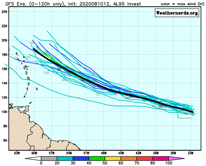 |
| - - - GFS Ensemble Forecast (August 10-15) - - - |
Thursday, August 6, 2020 11:37AM PDT - August
- Isaias is gone, and other than a tropical wave not much going on. It is already August, so let's see where we should look now for storm formation... The plot below taken from the climatology section shows storm origins over the last 76 years. It is color coded by how strong the storm became. Blue stars mean that it stayed 'just' a tropical storm, orange, red and pink stars became major hurricanes (Category 3, 4 and 5, resp.). We can clearly see that most storms are now forming in the Atlantic since it has warmed up sufficiently. Not good for us. It is "Cape Verde" season, with many storms forming just off the African coast. Of all storms forming this month, traditionally 44% are just tropical storms, and about 1 in 4 will become a major hurricane... So, if you haven't, now is a good time to check if you are prepared for the storm. Are your storm shutters in order? Do you have an emergency food supply? Batteries? Are your power banks (portable batteries to charge your phone) charged? Etc..., stay safe everyone and wear your masks if your government 'advises' you to do so.
Also, Klotzbach et al. of Colorado State just updated their hurricane forecast (see their website). Not surprisingly they upped their forecast. Things to blame: above normal sea surface temperatures in the Atlantic, below normal vertical wind shear, and a possible weak La Nina. Total storms expected: 24 (12 is normal, 15 more storms this season). Hurricanes: 12 (normal is 6.4, 10 more to go...). Major hurricanes: 5 (2.7 is normal, 5 more to go...). Chance of at least one major hurricane tracking through the Caribbean (a big area): 63% (42% is average). It we would reach 24 storms than it would be the second busiest season 'ever'. Leading the chart is 2005 with 28 named storms (a year where we ran out of names, and dipped in the Greek alphabet). That was the year of Katrina, but a year of relative calm for us. -Gert
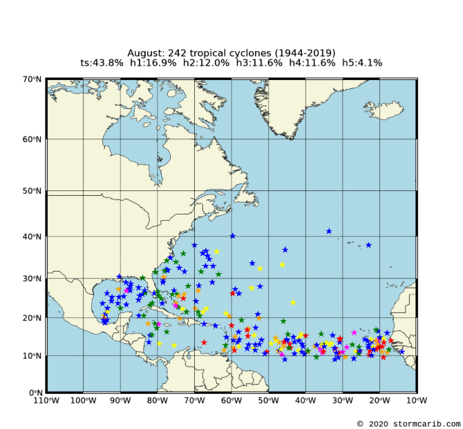 |
| - - - Storm Origins August 1944-2019 - - - |
Sunday, August 2, 2020 19:06PM EDT
- Isaias and the rest
-
Good night all,
Former hurricane Isaias, now TS Isaias, possibly rejuvenated hurricane Isaias soon, is slowly crawling up the Florida east coast at 9 mph with 70 mph winds, all offshore at this time fortunately yet tantalizingly close enough to the coastline akin to Dorian and a few others the last few years. It's amazing to see storms that can just parallel the coastline without touching, so close yet so far. This is probably the worst to forecast storm I have ever had to report on since I started back in 1997. What a system in constant flux, changing conditions, and fighting skills. It has done one good thing: Not a dry but a wet and scary run to test readiness, responsiveness, and the patience of all along with a pandemic crisis. However, the toll has been heavy, paid for by Puerto Rico again, eastern Dominican Republic, Turks and Caicos and the Bahamas.Â
TS Isaias has been sparking up lately and quite possibly will reup to hurricane status as shear has dropped slightly while over the very comforting warm waters of the gulf stream, dry air intrusion lacking and a non interaction/friction with land. This does not bode well with points above Florida, especially the Carolinas. Here just above Daytona Beach, it has been a weekend as usual except for preparations just in case as we all should do: prepare for the worst, hope for the best. Looking up the east coast, all my friends should be looking out for heavy rains, flooding, trees down, power outages and short lived tornadoes.
94L is striving to attain a name for herself, which would be Josephine, as it continues to trek to the NW several hundred miles off to the NE of Antigua. Swells, high surf, rip currents and small craft advisories will be the only effects to theÂupper Lesser Antilles from this wannabe as it churns towards fish storm history. But it does continue a pattern of early season activity.
It appears we will have a break for a week or two in the action but that will not last long so complacency should not overtake your vigilanceÂor preparedness. We have the historically busy 8 weeks ahead soon and if the early part of this season is a harbinger of things to come, no one will be immune or safe from the possibilities that are to come.
Be safe, be prepared and enjoy your Sunday evening!
Dave.
Saturday, August 1, 2020 08:26AM EDT
- Isaias and others
-
Good morning,
The Bahamas continue to take the brunt of discombobulated hurricane Isaias while Florida's east coast cringes and can only wait. 85 mph and moving to the NW at a much slower 12 mph, wind shear and dry air intrusion has been the twin factors in Isaias not becoming a Cat 3-4 hurricane. This is the good news. The bad news is Cat 1 hurricanes can still cause wind damage, power outages, spawn tornadoes, and cause severe flooding. Hurricane hunters are currently investigating the storm which is over very shallow and bathwater waters. We should have a better idea later today where landfall inÂFlorida, if it occurs, will happen. There is still much uncertainty. It does appear on satellite, despite the dry air intrusion and and wind shear interference, Isaias is trying to strengthen and wobbled a bit more west, bad news for the Fl coast.Â
Currently set to make landfall around West Palm Beach, a collection of pricey homes, mansion beachfront properties and high end shops, Isaias is expected after landfall to ride up the coast of Fla exiting just south of Daytona Beach back over open water as a strong TS. I am currentlyÂjust north of Daytona Beach and feel like a hurricane magnet! Regardless, this is what the latest model guidance suggests. A wobble to the west will be worse off for this coast while a wobble to the east could keep Isaias as a hurricane on a date with North and SouthÂCarolina then points all the way to Maine. Wobbles cannot be predicted and just a 20-40 mile wobble can mean the difference between severe damage and minimal damage. Hurricane Matthew is a very good example of this. Either way, not a good scenario for the whole east coast.
Ok off to the east of our Caribbean Islands we have two active areas. One, TD#10, had a small window of opportunity to get a name for itself but has now lost that opportunity. Located about 200 miles to the NE of the Cabo verde Islands just off the African coast, it is expected to turn west, weaken and dissipate. Maybe down the road it will regenerate. This season anything is possible.
Another area, basically a very weakÂtropical wave a few days ago, has moved into a more favorable area and appears to be taking advantage of it's opportunity. CurrentlyÂlocated about 600 miles to the east of Antigua, it's area of potential development is to the NW. Expected to turn to the NW then north, if it does develop, it will become a fish storm and no threat to the Caribbean.
The African Wave train continues to spew new potential trouble every few days and, as we enter August arriving into the peak months of hurricane season, it's even more important to prepare and be vigilant. There are 4 months left in the official season and we already have 9 named storms, a depression, and 2 hurricanes making landfall. A harbinger of things potentially on the horizon. This is not to scare anyone but to enlighten, educate and coax vigilance and preparedness.
Stay prepared and safe!
Dave.
Friday, July 31, 2020 08:11AM PDT - Isaias - Dorian
- I just wanted to add to Dave's post that we all feel with the people on Grand Bahama and Abaco who last year were terribly hit by Dorian. Having another hurricane coming at you, and hearing the sounds again, can be extremely stressful. While Isaias is by far not as strong as Dorian, it is still a hurricane, and it will move pretty close by Grand Bahama. Hope you can prepare your home for the storm, or have a safe place to go (complicated with COVID). -Gert
Friday, July 31, 2020 07:02AM EDT
- Hurricane Isaias + 93L
-
Good morning,Â
While some slept last night, TS Isaias was designated, an 80 mph hurricane around 11:40 pm last night, not long after the 11 pm advisory had been issued keeping it a TS. The difference is because hurricane hunter collected data had not reached the NHC yet in time for the 11am advisory. When it did, the storm was upgraded promptly instead of waiting for the intermediate 2am advisory in order to quickly update and warn the Turks & Caicos, Bahamas, and the east coast of the rising threat from this system. The pressure fell 9 Mb overnight indicating a strengthening storm system adding to the threat potential.
Isaias, the only 4 syllable hurricane with a mouthful to pronounce, replaced the infamousÂhurricane Ike, whose name was retired. Isaias is not expected to generate the same kind of damage and death toll Ike produced, but will have wide ranging and long lasting impacts. Unless something really changes, Isaias is expected to rake the Turks & Caicos, all of the Bahamas, and the entire east coast with winds, flooding rains, scattered power outages and storm surges. Hurricane warnings are up for the Bahamas where storm surge and wind damage will be prolific compounding the misery from hurricane Dorian last year and rebuilding efforts. Most of the stronger winds and rain are in the north and east quadrants with some dry air intrusion into the SW courtesy of Cuba and upper level wind shear.
Located about 350 SE of Nassau and having slowed forward speed to about 17 mph, Isaias will be moving over very warm waters and is forecast to slowly strengthen into a Cat 2 storm within 36 hours. Models have trended west overnight which puts Florida more in the crosshairs and I expect hurricane watches and warnings to start replacing the TS watch either as of 8 am or definitely the 11 am advisory as those models data plus new hurricane hunter flight data (they are in the storm now) is input into the forecast. If these trends continue, SE Florida could sustain a direct hit. As it stands now, Florida is on the weaker side of the storm with TS force winds, copious amountsÂof rain, and isolated tornadoes as main threats. Again, this is how it stands now. There are plenty of scenariosÂthough.
The uncertainty will soon become a certainty and that cone of uncertainty will certainly shrink over the next 24-36 hours. Whether you're in the cone or on the fringes, you can and will feel some impacts. This is a large storm with dangerous potential. As a TS, look what it did to Puerto Rico, an island devastated by Hurricane Maria in 2017 and still trying to recover.Â
As we watch Iasias try to join the ranks of the other 11 retired "I" storms and pray he doesn't, 93L is located about 250 miles SE of the Cabo Verde Islands with a half raised window of opportunity to become a TD but that will close quickly and 93L will become a fish storm and no threat to the Caribbean. Another wave located about 900 miles to the east of the Caribbean has very low potential at the moment and is expected to turn NW in a few days again, not a threat at this time to the Caribbean. There are a few vigorous waves crossing the African continent which will bear more vigilance and wariness in the coming weeks.
Be safe and prepare.
Dave.
Thursday, July 30, 2020 07:32AM EDT
- TS Isaias
-
Good morning,
Finally, as long expected, PTC #9, morphed into TS Isaias. Several reasons it took so long. The dry air to the north, it's broad, elongated structure stretching about 800 miles wide, lower humidityÂlevels in the low and mid levels, plus it's forward sprinters speed of 23 mph which didn't allow it to catch up with itself and take time to consolidate. However, it's ridden itself of most of these issues although it is still a large system and trucking along about 21mph to the NW as a 60 mph much better consolidated TS.
After lashing the lower Lesser Antilles yesterday and continuing to drought bust PR (multiple flash flood warnings are up) and all of the VI's with heavy rain bands, TS Isaias is expected to be north of Hispaniola by tonight and near the SE Bahamas tomorrow morning with the Turks and Caicos caught in the middle. TS warnings are up for most of the Greater Antilles, T&C, and the Bahamas.Â
Currently located about 60 miles to the WSW of Ponce PR, it's soon to be forecasted interaction with the mountains of the DR will determine alotÂof things, mainly future track and intensity. It's almost a given the mountains will disrupt the circulation if it does meet the mountains, and where that circulation reforms after that interaction is key much like Hurricane Dorians center was relocated to the north after interaction with the mountains in St. Lucia in 2019 and we know how that turned out. Farther to the east and it looks like the storm will track throughÂthe Bahamas and up the coast but sparing Florida a direct hit. Farther to the west, Florida is still in the crosshairs and even it's possible the GOM comes into play. It's a tricky forecast with Hurricane Hunters expected later this morning and this evening hoping to give more details as to structure, strength and speed.
Right now it actually looks like the center is gonna try to shoot the gap between PR and the DR aka the Mona Passage limiting interaction which would be a bad thing going forward. Then, a hurricane will be a definite.Â
Either way, with TS winds stretchingÂup to 415 miles from the center,, it's a sure bet almost everyone will be impacted direct hit or not. Flooding rains, gusty, even hurricane force winds, power outages and a surging ocean causing coastal flooding and erosion will occur. Please get your preparations done asap if you haven't already. This one isn't leaving much time.Â
Bottom line, a strong TS remains while a hurricane is probable. T&C, Bahamas and the entire SE coast of the US should be vigilant and ready.Â
Be safe and prepared.
Dave
Wednesday, July 29, 2020 07:45AM EDT
- The "I" storm
-
Good morning!
The sprawling systemÂthat has been designated Potential Tropical Storm or PTC 9 is still just that this morning, PTC 9. However, it is packing the same impacts as if it was a named storm at the moment with heavy rains, gusty 45-55 mph winds, flooding, and landslides.
Why isn't it named TS Isaias yet? No clear closed low level circulation. Hurricane Hunters have been unable to verify and close off the circulation hence it remains with high confidence, PTC 9. This designation allows the NHC to issue advisories ahead of what they say will become a named storm in order to make the public aware of the dangers and potential ahead. With TS warnings stretching from Martinique to the DR currently, the impacts will be as stated above. The rain is definitely needed as PTC 9 could be a drought buster for PR and the eastern islands but we don't need it all at once. Overnight, this system has strengthened a bit wind wise and tightened up so I do expect the name, Isaias today at some point.Â
Where it goes from the Eastern Caribbean is not so certain. The stronger it gets, the more of a northerly component it will take, possibly affecting the Bahamas, Turks and Caicos, east coast and Bermuda. The more southerly trek would take it south of the VI, PR, the mountains of the DR and possibly into the Gulf where there is no escape but landfall. That trackÂcould slow it down development wise as it would interact with the mountains of the DR, disrupting any circulation that exists. While short term confidence is high, long term is not so much so time will tell but until it forms that closed circulation, it's a coin flip. I see a potential track similar to TS Fay in 2008 with Cuba, Haiti, the Dr and Florida the most susceptible to PTC 9.Â
A bit of trivia. The "I" storm is the most retired letter among hurricane names with 11. The next three, A,C, and F have only had 7 each retired. And we all remember the last one, hurricane Irma in 2017.
Be safe and prepared. This season is just ramping up and it's not even August yet.
Dave
Tuesday, July 28, 2020 09:16AM PDT - Number Nine
- Invest 92L has been upgraded to Potential Tropical Cyclone Nine. It still looks quite disorganized, and I don't see much circulation on the satellite loop. Regardless, winds are already 40 mph, which is actually tropical storm strength. I guess the only thing missing is a center of circulation to call this 'tropical wave' a tropical storm or depression. The advisories show that it will a tropical storm within 24 hours. The next name on the list is Isaias.
Where will it go? Depends on what you mean by it... Since there is no real center yet, don't pay too much attention to the forecasted track. This storm for sure is not a line. Just look at the satellite image above, high winds and rain will be felt far from the 'center'. Indeed, tropical storm watches and warnings have been issued all the way from Martinique in the south to the Dominican Republic (if your island is not specifically included, but your neighboring islands on both sides are, then consider yourself being on a watch/warning as well, just to be safe...).
The NHC thinks this storm will only strengthen slowly. Although sea surface temperatures are warm enough, this storm is still too disorganized. I think that indeed the storm will not all of a sudden become a monster wind-wise, like we have unfortunately seen many times in the past. Below image shows earliest reasonable arrival time of tropical storm winds. So people in the northeastern Caribbean start preparing for tropical storm conditions starting tomorrow AM! As most of the times..., rain will be the biggest threat. Torrential rainfalls will cause flash flooding and mudslides... Stay safe! -Gert
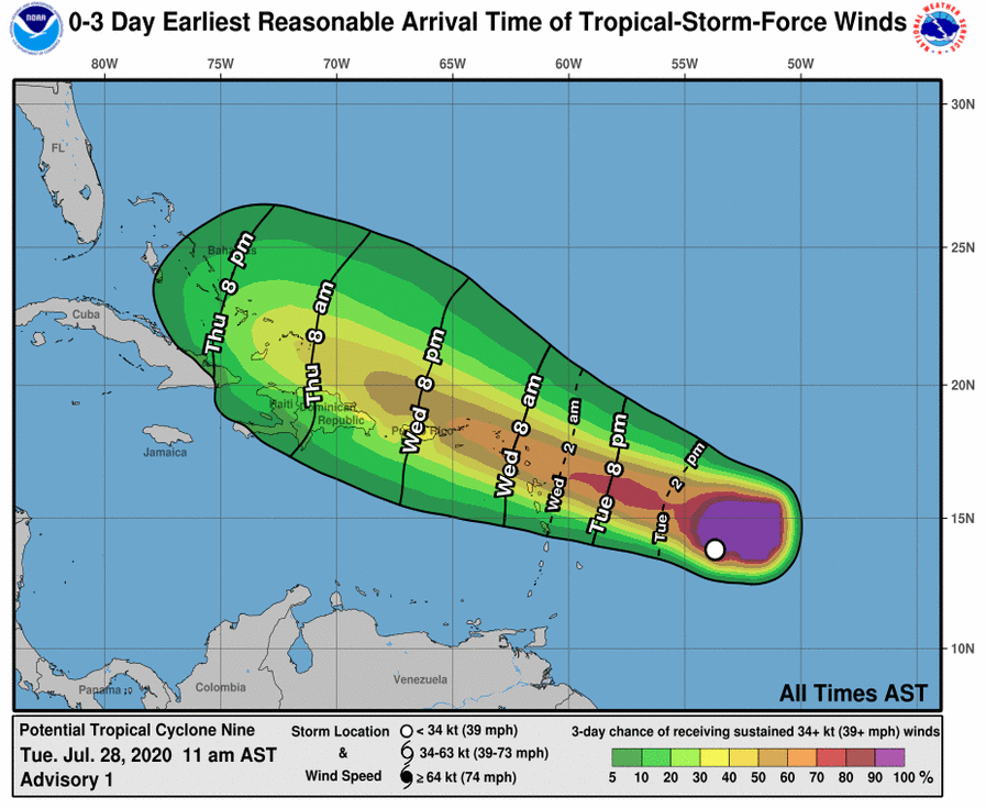 |
Expected Arrival of Tropical Storm Force Winds {Tue, Jul.28 11:00AM)
Latest image at NHC |
Monday, July 27, 2020 09:18AM PDT - Invest 92L
- Invest 92L, about 1000 miles to the east of us, doesn't look like much on satellite images, but slowly but surely it seems to get organized a bit. Sea surface temperatures are plenty warm ahead of the storm, even above normal... (see last image on the satellite page). Right now the NHC gives it a 80% change to become something within 2 days. It will arrive Wednesday, hopefully it will pass just north on the islands, but a lot of models have it just going over the northeastern islands (see link to spaghetti plot above and below ensemble plot of the GFS model (from Weathernerds.org, ECMWF and UKMET Ensemble plots available as well). How strong will it be when it arrives...? Here models vary as well, probably a tropical storm, but it might be a Category 1 hurricane (see intensity link above and ensemble plots). However, as I mentioned above, sea surface temperatures are quite high, which act as fuel for the storm, so we could be in for a surprise. Hopefully not of course. As of now 92L is still 'nothing', but we will have to follow it closely. -Gert
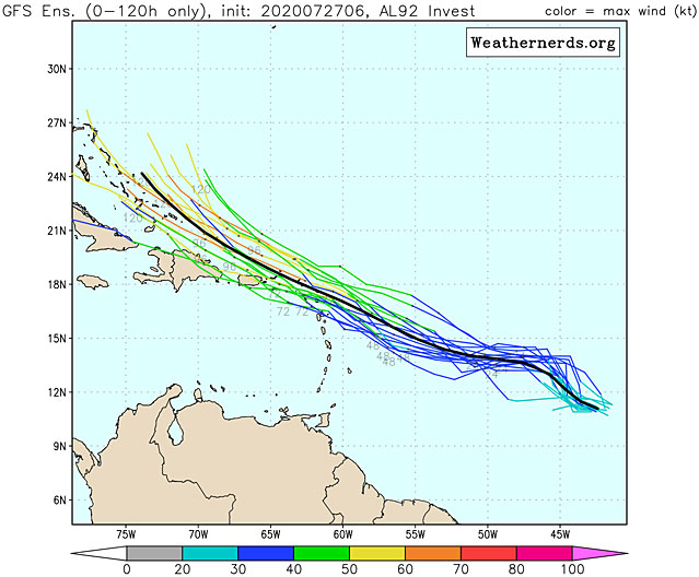 |
| - - - 5 Day GFS Ensemble - - - |
Saturday, July 25, 2020 09:47AM EDT
- Activity all over!
-
Good morning,
There's a saying that everything is bigger in Texas. Well, in this case, Hurricane Hanna is going to prove that statement. The 1st hurricane of the Atlantic season, Hanna, is about to plow into Texas with a large eye and large circulation as a Cat 1 forecasted storm south of Corpus Christi. I believe she also has a possibility of reaching Cat 2 still before landfall as this storm is strengthening on approach. Heavy flooding rains will be a big issue especially from the landfall area south although the whole Texas coast will receive generous amounts. Tornados are possible as well while storm surge could reach 5 feet in some areas. While Hanna is landfalling in an area with more cattle than people, life threats are real. Hanna should dissipate rather quickly after landfall and Mexico will see heavy flash flooding rains in it's mountainous areas upon Hanna's demise.
Gonzalo has been fighting an uphill battle for quite a while now and is no longer a threat to reach hurricane status, much less stay a tropical storm. The 5 day cone doesn't even exist for Gonzalo as all the models are in consensus agreement that Gonzalo will fall victim to the graveyard that is the Eastern Caribbean Sunday due to sinking air (subsidence), proximity to the South American coastline, and low humidity aka dry air. He has literally ran out the string on the moisture trail. However, before that happens, Gonzalo will dump copious amounts of rain on the southern Windwards. TS warnings are still up for Grenada and Tobago.
Gonzalo was the vanguard of the Cape Verde season storms which has obviously started early this year and paved the way for more dangerous things to come. One of them might be the newly anointedÂ92L.ÂÂ
92L at this point, is given a 60% chance to develop in the next 5 days. Early track models show no continuity as they show an impact somewhere along the eastern island chain, nowhere specific yet. Of course it's far too early to pinpoint impact sites. It's far too early to pinpoint intensity as well. The early models show a mid grade TS in 4-5 days. If the dust clears and wind shear remains low, we could have a hurricane on our doorstep in a week.Â
With this pickup in activity, and the pandemic still raging, it's more important than ever to be prepared and vigilant. Don't wait to prepare right before a storm strikes as you will be subjected to a shortness in supplies and long lines which are frustrating not to mention lack of social distancing and mask use.
Friday, July 24, 2020 08:57AM PDT - Gonzalo
- Gonzalo is still 'just' a tropical storm, and it looks pretty disorganized now. See the satellite image above, which I moved a bit to the south to see the storm better. As hinted at yesterday, right now it doesn't look like Gonzalo will reach hurricane strength. This doesn't mean that it is not a dangerous storm. It will still produce a lot of rainfall over the southern Windward Islands, which could lead to flash floods and worse. Rain, not the wind, will be Gonzalo's main threat!
The forecast track has changed as well. It is more to the north again and west ("earlier"). Right now the center is expected to move over the northern part of Grenada on Saturday night, with tropical storm winds arriving in the afternoon. However, don't pay too much attention to the exact path, since the rain will be the main threat it is going to affect a much larger area than just Grenada.
Lastly, a tropical wave just came off the African Coast, and while still early in the 'Cape Verde' season, the National Hurricane Center is giving it a 30% (low) change to develop into something. Right now it doesn't look like it is going to bend north before reaching the islands, so we'll have to keep an eye on it. Oh, and yes, we have Tropical Storm Hanna as well in the Gulf of Mexico, this one is expected to make landfall in about 30 hours just south of Corpus Christi, also with this storm, rain is the main threat... Stay safe everybody! -Gert
Thursday, July 23, 2020 08:55AM PDT - Gonzalo
- Gonzalo is still tropical storm. There is a lot of uncertainty if it will further strengthen into hurricane or not. Sea surface temperatures are plenty warm for Gonzalo to strengthen and there is not much wind shear ahead. However, Gonzalo will encounter some low humidity. The advisories note that since this is a small storm it is more sensitive to adverse conditions and can fall apart more easily. Indeed, some models see no further strengthening (even weakening) of Gonzalo, while other models expect Gonzalo to become a hurricane. Right now the official forecast has Gonzalo top out as a Category 1 hurricane with 80 mph winds.
Gonzalo is going a bit more south than earlier forecasted. That is good news for Barbados, it should stay about 100 miles to the south. The center is now expected to move just to the south of Grenada Sunday AM. Hurricane watches have been posted for Barbados and St.Vincent and the Grenadines and I expect Grenada to follow, as well as Trinidad and Tobago. Stay tuned! Use the tools to see how the storm might affect you. -Gert
Wednesday, July 22, 2020 07:46AM EDT
- Gonzalo and Hanna?
-
Good morning!
I hope everyone is staying safe and well during the turbulence of 2020.
Quick note on 91L. It is on the move into the GOM and is expected to become a TS before a beeline landfall along the south to mid Texas coast unless wind patterns change. Regardless of it's status, named or not, it will bring copious amounts of rain, sporadic power outages, and probable flooding in some areas. Other areas say Louisiana should watch as well in case those wind pattern shifts.Â
On toÂthe star for the next few days heading for a date with the Southern Windward Islands as a definite TS and a good potential Cat 1 hurricane: I present! Gonzalo. The island nations of St. Lucia, Grenada, Barbados, and Trinidad Tobago on the south side of the storm all must prepare for a potential Cat 1 hurricane although most models forecast a strong tropical storm. Well, there's not much difference between a 65 mph TS with higher gusts to hurricane strength and a 75 mph with higher gusts bare minimum Cat 1 hurricane. Flooding rains, wind damage, crop damage especially on Grenada, power outages, and potential loss of life are all aspects of these systems. It must be noted that small systems such as TD#7/Gonzalo are subject to quicker, more dramatic changes in intensity so nothing is certain at this time.
Currently, approx. 10.1N, 43.0W moving along just a hair north of west at about 12mph, TD#7 aka Gonzalo shortly consolidated his position and banding features have formed with outflow in all quadrants, quite possibly winning the best TD Look Award since 2004 not named yet by the NHC. Way uglier less organized storms have been named, most along the east coast. If named today, Gonzalo would be the earliest 7th named storm on record beating it by 1 day. I cannot fathom it would not be.
I would be remiss if I didn't warn that these are consensus model runs on it's trek however, there has been a slight shift northward in their latest runs so no matter where you are, all along the Lesser Antilles chain should be aware and prepared as it is still far out enough to pull a northward stunt. The issue if it does though is it will have to battle with more copious amounts of dust but a well formed system should be able to protect it's core from ingestion.This potential also takes the Eastern Caribbean graveyard out of the equation.
Behind soon to be anointed Gonzalo, the African continent has opened it's tropical wave bowling alley despite being ordered to quarantine. Alleys are opening every week and we are entering the ramp up in activity period. 3 Invests in 5 days is a portend of things to come. The Saharan Dust Layer aka SAL will only protect us so long as will wind shear, which has not been prevalent this year so far. Each waveÂfrom now until the end of October needs to be taken as a potential strike.
Be safe and prepared!
Dave
Tuesday, July 21, 2020 08:18AM EDT
- Tropics and GOM
-
Good morning all,
I do not have much time this morning so will post more detail later.
90L: Moved into La and Texas with heavy, possibly flooding rains. No development possible.
Soon to be 91L: Lashing Cuba, the Keys and South Florida with heavy rains and gusty winds. Moving eventually into the GOM with moderate shear and very warm waters for which development is probable and once in the Gulf, has no escape. Depends on where the low closes off dictates where potential landfall is along the gulf coast. However, it looks like Hanna will eventually form and could be nasty. Air Force reconnaissance is scheduled for later today if necessary but I bet definitely tomorrow.
99L: Looks to make TS Gonzalo soon. Already impressive on visible satellite, currentÂtrack takes 99L through the lower Windward Islands and into the eastern Caribbean graveyard and the current models forecast it to die there as so many before have. However, at the moment, not forecast to become a hurricane even though shear is low and the dust shield is down. Main reason as it's very low around 9 degrees N, 40 degrees W and has to escape the ITCZ which it will.
No matter what, it's starting to ramp up in all basins, even the East Pacific so preparation and knowledge are the keys. This is standard procedure for any hurricane season but then again this is 2020! I doubt this hurricane season will be standard. Stay safe and prepared!
Dave
Thursday, July 9, 2020 14:23PM PDT - Storm Number 6!
- Yikes, it is only July, and here we already have storm number Six, named Fay! This is the system that travelled from the Gulf of Mexico over land and reoganized over the Atlantic, just off North Carolina. It is probably going to be a short-lived storm, moving closely along the US East Coast, possibly going over New York City. Luckily it is not expected to strengthen much, although it is currently over the warm Gulf Stream, when it goes more north Fay will be over cooler waters. Again, this storm will form no threat to us in the Caribbean.
Since it is the month of July, the below image from the climatology-section shows the storm origins (and how strong they became) for the month of July. I count about a quarter of all July storms since 1944 forming east of the Caribbean in the Atlantic, our 'danger zone', though only 5% of those became major hurricanes. Still, we have to start looking east... -Gert
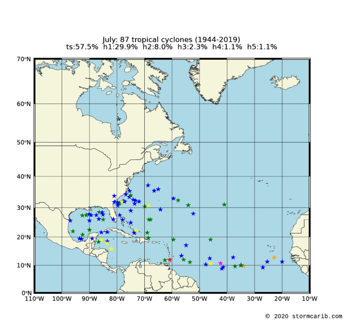 |
| - - - July Storm Origins - - - |
Monday, July 6, 2020 08:59AM PDT - Edouard
- Last night Tropical Depression Five was upgraded to Tropical Storm Edouard. It is currently well south of Newfoundland, yes, quite up north indeed. The storm is moving fast over the open Atlantic, and is no threat to land. It might cause some unsettling weather in Ireland or the UK later.
There are two other areas of interest, one near Florida (Gulf side) which we don't have to worry about in the Caribbean, however, it may reappear over water on the 'other side' in the Atlantic and become something. We also have a tropical wave approaching the islands down south. Although currently not forecast to develop into a depression or worth, it will bring some high winds and heavy downpours when it approaches Barbados and the islands beyond. See the satellite image above for its current location. -Gert
Saturday, July 4, 2020 10:23AM EDT
- TD#5
-
Quick update: Advisories to be issued on TD#5 as of 11am NHC advisory.
Dave
Saturday, July 4, 2020 10:16AM EDT
- Edouard maybe already?
-
Good morning and Happy July 4th America!
A happy 4th it will be weatherwise for the east coast of America as well concerningÂInvest 97L but maybe not so much for Bermuda. Trekking ENE about 15 mph, 97L has about a 60% chance of development into a depression at least, with earlyÂmodel guidance suggesting a peak mid tropical storm of 55-60 mph in about 3 days.The next name on the list will be Edouard in an already early active Atlantic season. Bermuda should start receiving impacts of thunderstorms, high surf, gusty winds, and rip currents tomorrow evening while east coast impacts will be minimal in the way of higher surf and increased rip currents. Then, he will move off to visit Europe to help cool off their heat wave.
The eastern Pacific has picked up as it usually does before the Atlantic and there are several potential areas to watch but none appear to be a threatÂland wise at the moment. A note in the far Western Pacific not reallyÂtropical even for Japan but deadly and wow, what a deluge. Credit to Sayaka Mori in Japan several hours ago: 381 mm of rain fell within 6 hours translating into 2.5 inches an hour aka 15 inches in southern Kyushu. TheÂKuma River has flooded, houses have collapsed and sadly, there is a death toll.
Meanwhile, the GOM and the Caribbean, both east and west, are pretty quiet. Most of the Caribbean, especially the Eastern, could use some rain. The USVI's and BVI's are dry as a bone pretty much. Why? Our two main protectors from storm formation, wind shear and that seemingly omnipresent, drying out the atmosphere Saharan Dust, have been very active so far but as we well know, these will falter as we approach the peak of season, mid August to mid October. With SST's very warm already (the fuel of the storm), wind shear falling, the Saharan Dust level diminishing, and the absence of El Nino in the Pacific, it still looks like an active season ahead. It also looks like some decent rains will start to arrive soon and so will the double edged sword.
Preparation and knowledge is the key to protection of life and property. The property can be replaced. You cannot. Remember, it only takes one. Not 15.
Dave
Monday, June 22, 2020 18:39PM PDT - Dust and TD#4
- We have a major Saharan dust event underway on the islands and it is the Talk of the Town. Check out the pictures posted by the special hurricane correspondents on the right. Also see the 'true-color' satellite image below, clearly showing dust over the islands. And it looks like more is on the way later this week! A good source to see images of the Saharan Air Layer is at http://tropic.ssec.wisc.edu/real-time/sal/ (the below image is cropped from the GOES-16 Natural Color one).
Dust is actually good for suppressing hurricanes. It is still a bit early for the Atlantic Cape Verde storms, so hopefully we get some more dust later. Although, dust is not good for people with allergies and/or respiratory illnesses, as Barabar on St.Maarten noted... Nevertheless, Tropical Depression Four just formed in the Atlantic, albeit well north of it, off Cape Cod. It might become a named storm, but it will be of no threat to (is)land (incl. Bermuda). -Gert
Saturday, June 6, 2020 16:59PM EDT
- Cristobal plus
-
Good afternoon all,
It's highly unusual to find a cone of uncertainty that stretchesÂfrom the GOM all the way well into Canada but that is what TS Cristobals is and continues to be. Heck, the 5 day cone shows Cristobal still a depression over the UP of Michigan! Again highly unlikely but wow how this guy will continue to ramble on well after landfall probably as a very strong system through Canada and the Great Lakes.
First things first though, the Atlantic and the Caribbean. East to NE of Bermuda, a low pressure system could form but it's chances are slim at this time. If it does, it would most likely move NW or WNW which could make things interesting for the NE or Canadian Maritimes. If it does reach named storm status, it would become Dolly. Will Dolly meet up with Cristobal if this scenario plays out? That would be a very interestingÂsituation. However, remote for now.
The rest of the Atlantic and Caribbean are pretty quiet. A few tropical waves are marching across the MDR or Main Development Region of the Atlantic but we don't usually look for much development in this area at this time of year. SST's are running warmer than usual and wind shear is moderate but Saharan Dust is ever present, stifling any early season attempt. The only wave that has any attention is the one that just splashed down off the African coast but that one's main hindrance is it's proximity to the ITCZ or Inter Tropical Convergence Zone. Until it escapes to over 10 degrees north, it has minimal chance of doing anything.
Cristobal is poised to become the second land falling named storm of this very early active season. TS Arthur did not make an actual landfall as it's COC or center of circulation did not touch the Outer Banks, coming within about 20 miles of. Cristobal will be dangerous whether a high end tropical storm or a Cat 1 hurricane, which is entirely possible. It has some work to do wants to achieve that rare event in June. It has to seal off the western side from dry air intrusion, slow down a bit in order to consolidate it COC and bring it's windfieldÂin closer to the core. Cristobal is massive so rapid strengthening is remote. Even when the pressures drop, it is so big the wind field might not have time to catch up.Â
That said, Cristobal has a chance for strengthening overnight before land fallÂon Sunday. Whether it does or not, storm surge, rip currents, heavy rain and flooding along with tornadoes are on his menu. It is not a polite menu either. This is not Sunday Brunch. Please evacuate if told too. The effects of this system will be felt over a very large area and will continue to be for days to come.
Preparation and common sense are keys to survival and the aftermath.
Dave
Tuesday, June 2, 2020 09:43AM PDT - Cristobal
- Tropical Depression 3 has been upgraded to Tropical Storm Cristobal. This is the first time ever (=since 1851) that 3 named storms have formed this early. 2016 was close, with the third storm forming June 5, and in 2012 the third storm formed on June 17. Don't be fooled, this is a very dangerous storm. Because it is hardly moving it will cause prolonged periods of torrential rainfall in Mexico and Central America. There already have been deaths reported due to flooding in Guatemala and El Salvador. It doesn't look like it will start moving out of the area until Friday... I have shifted the satellite image above a bit more to the west to get a better view at this storm. -Gert
Monday, June 1, 2020 21:07PM EDT
- TD#3/Cristobal
-
Good evening all,
I trust everyone is doing well, staying safe and healthy while riding out the pandemic that envelopes the world in different degrees and stages. Please be safe, stay aware, and prepare. BTW, looting and violence will not bring or realize justice. Looting a 50" TV will not assist getting justice; that's just taking greedy advantage of the situation. Back to the weather.
Gert, Thank you for 25 years of silver anniversary for providing a forum in which to enrich, enlighten, inform, sometimes chastise (on my part), and educate the Caribbean and others about the Atlantic Hurricane Season and it's contents which includes, watches, warnings, perils, preparation, devastation, relief and recovery, etc.... Thank you also for allowing me to participate on this site since 1997 I believe. I enjoy the weather while sharing what I know and observe with others with the hope it helps someone and saves lives. Yes, Hurricanes Irma, Maria, and Dorian in the last three years have been eye openers to say the least. Having personally went through Irma and Maria within 12 days tests your will, your mind, your resources, your beliefs and trust. Just saying, I love the weather but Mother Nature, please take all the next 20 years worth of storms OTS aka make them fish storms to talk about, not remember.Â
So, June 1st, the first official day of the 2020 Atlantic Hurricane season starts today but tropical activity, while minor, has been prolific and surprising already in the month of May. TS Arthur, makes a not so surprising appearance along the SE coast brushing the Outer Banks while TS Bertha, who would have never been recognized before the 1970's, rapidly sloshed into South Carolina. TS Bertha was basically a Sunday visit to the buffet: One hour from designation as a TS to landfall. Second shortest on record by 15 minutes.Â
Now, we have TD#3. Soon to be TS Cristobal, it will linger and lurk for the next few days around the Bay of Campeche. Heavy rains and flooding will be Central Americas issue no matter what. Future tracks are uncertain. West into Mexico. Or, Saturday a TS in the GOMEX.Then where? Beyond uncertain. So, anywhere along the GOM and Florida need to pay attention, heed, and prepare. This one has no zeroed in on point yet.
Bottom line prepare no matter what. La Nino is non existent. The Atlantic, unless wind shear and Saharan Dust are seriously prevalent, will be highly active. I have been saying way before TWC and others: It only takes one to land on your island or house. I find it funny they are now using that statement. However, it is true no matter who says it.Â
TS Cristobal which is almost inevitable, has some place to land with evil intentions. Central America's issues with this system will be morphed into a GOM problem of where, what as and when. Landfall is a certainty once in the GOM as there is no real exit lane unless any of them dipped south and exited the Straits of Florida into the Atlantic which I believe has ever happened yet.Â
Have a safe and healthy evening. Seems like it's time to strap on the tropical seat belt!
Dave
Â
Monday, June 1, 2020 2:11AM EDT - Silver Anniversary
- Update 5PM AST: Tropical depression 3 formed right where we would expect it from the plot below, down in the Bay of Campeche, off Mexco. It is expected to become a tropical storm soon (Cristobal). It is going to move pretty slowly, so the rain will be the biggest problem. The advisories indicate up to 20 inch locally!
A huge milestone, this is the 25th year for this website! I started it back in 1996, when I realized that the mainstream news coverage of hurricanes in the Caribbean is largely absent or too generalized to be worth anything. The 'internet' was very different back then, blogging was not a word and Google didn't even exist yet. We were using the Altavista search engine and Mosaic browsers... A lot has changed, and news is easier to get nowadays, including first hand reports through Facebook. But for now, this website still fills a need.
A special thanks to Dave McDermott who helps me with writing hopefully easy to understand updates. Thanks to all the special hurricane correspondents on the islands. Without all these volunteers this website would be pretty boring! Some have been with us for a very long time. And of course, since there are considerable costs associated with this high traffic website, thank you all who have donated money, esp. the ones who have given year after year! Thank you all!
Another thing that came through recently and which I have been trying to get for many, many years is the ownership of the domain name stormcaribe.com, since many people like to add an 'e' to stormcarib. No one was doing something useful with that domain, but somehow different registrars kept renewing it, and I was unable to steal it when the registration expired. At one point is was even a porn site! When you type in stormcaribe.com by mistake you will automatically be redirected to stormcarib.com.
OK, today marks the first day of hurricane season. We have already had two storms. Pretty unusual, it only happened 6 times before in the last 170 years (see my earlier post). Although it seems to become more common, since half of the cases happened in the last 10 years. Hmm, I wonder what the cause of this could be... Many of the forecasts predict an above normal season. Pretty soon Colorado State will come out with their updated one. A lot of it will depend on the ENSO status. El Nino is good (suppresses hurricanes), La Nina is bad. The latest ENSO forecast from 2 weeks ago predicts mostly neutral conditions through August (65% chance, with 25% chance of La Nina and 10% El Nino). In September chances for an La Nina are going up a bit (50% neutral, 40% La Nina, 10% El Nino). So not really optimal and this is probably the main reason for the above average hurricane activity season forecasts. At the time of the last forecast by Colorado State La Nina chances were a bit lower (45% neutral, 35% La Nina, 20% El Nino), so I suspect that the number of storms they forecast will go up a bit. Below the names of the storms and pronunciation used this season:
Name           Pronunciation    Name            Pronunciation
-------------------------------------------------------------
Arthur         AR-thur          Laura           LOOR-ruh
Bertha         BUR-thuh         Marco           MAR-koe
Cristobal      krees-TOH-bahl   Nana            NA-na
Dolly          DAH-lee          Omar            OH-mar
Edouard        ed-DWARD         Paulette        pawl-LET
Fay            fay              Rene            re-NAY
Gonzalo        gohn-SAH-loh     Sally           SAL-ee
Hanna          HAN-uh           Teddy           TEHD-ee
Isaias         ees-ah-EE-ahs    Vicky           VIH-kee
Josephine      JOH-seh-feen     Wilfred         WILL-fred
Kyle           KY-ull
 Finally, I have updated the climatology section. Last time I did it was in 2011 so it was about time. A lot more work than I thought, since my scripts weren't really working anymore and I wanted to make nicer maps. I analyzed almost 1900 storm tracks from 1951-2019 (see image on the right). The climatology section contains over 600 webpages and over 4500 images. There are different sections: maps of storms that passed by your island, peak of the season for your island, five year analyses (are we seeing more storms lately?), hurricane capital of the Caribbean, and more. Also included is an analyses of where storms form for each month. Below is the map for June. In the last 76 years (since 1944) we had 57 storms form in June, 75% of them became 'just' tropical storms, no Category 4 or 5 hurricanes. More importantly, for us in the Caribbean it looks pretty good. Hope it holds true!
OK, this turned out to be a much longer post than I anticipated, so much new news :-). Everybody good luck this season! Hopefully things will go back to more or less normal regarding COVID-19 soon, with tourists coming back to the islands! Stay safe and don't do stupid things! And if you are able to, consider making a donation to the website, so that it can continue for many years to come! -Gert
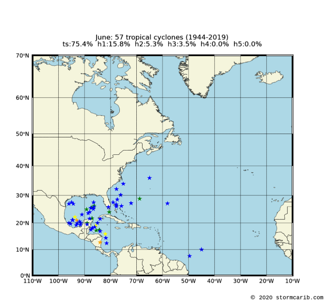 |
| Storm Origins for June |
Wednesday, May 27, 2020 11:55AM PDT - Bertha
- And surprise, surprise, here is storm number 2, Bertha! It formed this morning just before making landfall in South Carolina. Since it is over land already Bertha will not be long lived, although it will dump a lot of rain...
I am working on updating the climatology section (a lot more work than I expected, maybe that's why I hadn't updated it in the last 10 years or so...), so I have all the data to figure out how uncommon it is for two storms to form before the official start of the season. It is actually not that uncommon for storms to form before June 1, this is the 33rd time since 1851 (about every 5 years). However, this is only the 6th time that 2 storms have formed. The other years were 1887, 1908, 1951, 2012 and 2016. See the table below, showing date of formation, storm id, name, maximum wind (mph) and category. In 1908 two hurricanes formed before June 1 and in 2016 we did have a hurricane in January! In 1981 there were actually three systems before the start of the season, but the first 2 were tropical depressions (which I didn't count, I only include 'named' storms that formed between January 1 and May 31, so I didn't include storms that formed in December and persisted in January either). Five more days... -Gert
date      stormid  name   wnd cat
1887/5/15 AL011887 UNNAMED 69 TS
1887/5/17 AL021887 UNNAMED 58 TS

1908/3/6  AL011908 UNNAMED 98 H2
1908/5/24 AL021908 UNNAMED 75 H1

1951/1/2  AL011951 UNNAMED 63 TS
1951/5/16 AL021951 ABLE    92 H1

2012/5/19 AL012012 ALBERTO 58 TS
2012/5/25 AL022012 BERYL   69 TS

2016/1/7  AL012016 ALEX    86 H1
2016/5/27 AL022016 BONNIE  46 TS

2020/5/16 AL012020 ARTHUR  60 TS
2020/5/27 AL022020 BERTHA  50 TS
Saturday, May 23, 2020 20:46PM EDT
- A PSA & Season Approach
-
Good evening,
I trust and hope all is well and safe with all of you. The last 10-12 weeks have been life altering to most, mind boggling to some, a nuisance to many and eye openingÂto all whether you believe or not. Use common sense and follow guidelines, while they may be a nuisance and inconvenient, they do protect and save lives. The more vigilant we are now, the quicker the return to a near sense of normalcy although I believe the old normal will be relegated.
PSA. This is a weather site and we all know many of us have gone through many weather events personally, myself included especially 1995 and 2017. However, this afternoon, while weather related, was unexpected and a lesson for all.Â
I now split my time working between Florida and the US Virgin Islands, my former home for 30.5 years. Rip currents are no stranger to Puerto Rico and the Virgin Islands, especially the northern facing coasts. However, beaches are not prevalent on that side in the VI while more numerous in PR however, deaths and accidents due to these rip currentsÂare few and far between there. Florida coasts however are a far different story.
Readers Digest version: Today, while standing 20 feet farther into the ocean than my girlfriend Melody, say 40 feet into the water, enjoying the surf, sun and just being outside and in the 77 degree water, I said to her: "hey lets walk over to that sandbar."Â Low tide at 3 pm, the sandbar was a mere 75-100 feet away. She smiled and nodded. I watched her turn to walk that way. A wave broke over my head and then quickly another. When I came up out of those, MelodyÂwas 200 feetÂaway. I said a few curse words and then another wave broke over me. I came up and noticed her even farther away. I realized wow, I was in a rip current. Best guess was 6 mph. That's 1 mile per 10 minutes. I immediately started to swim parallel to the beach. Many waves broke over me for what seemed endless and holding breath in between those waves was a challenge as I was in the breaker zone but then I touched a sandbar, stepped up and a few steps later broke freeÂof the current. Standing upright and seeing my girl Melody and the rest of the people was a relieving sight. Note: The lifeguard was attending another emergency north of me so it wasn't his fault he didn't see me swept out. After recounting the events with Melody, we returned to the water, more aware and lesson learned. My point to all here is, yes they exist, no we don't think about them that much in the Caribbean but when warned, heed. They are potential sneaky killers. I was lucky. I also learned a lesson. Yes it was by chance I stepped in ones path with no idea it was there but the lesson is learned. Awareness of your surroundings and knowledge of what to do in case the unexpected happens, as in this case, can mean the difference. Tonight, upon reflection, it hits home to both of us much harder. What if? But, positive is how I live so moving along and not dwelling. But wow.Â
Now to the future season. El Nino is going to be almost non existent. Gulf of Mexico and Atlantic waters SST (sea surface temperatures) are above average. Wind shear, one of our best friends during hurricane season, looks to be on the down low. Saharan Dust, another mitigating factor, will always be present but will not be the almighty savior it has been over the preceding years. This season looms to be very active. Where and when are variables as are the weather conditions at that precise time of formation and trek. Our mission is to be empowered with knowledge, experience and to be prepared.Â
Eight days from now we will have the official start of the 2020 Atlantic Hurricane Season. TS Arthur has already been a premature nuisance and a few of the computer models have suggested some activity in the Western Caribbean and GOM in the next few weeks. This weekend, here in Fl which has been in a drought of all sorts, a tropical wave is expected to lift up from the south and provide anywhere from 1/2 inch to 8 inches over most of the peninsula. Drought buster in some areas while a drought wimp surely in others. Main day will be Memorial Day. We shall see.Â
Stay safe and well. Get and be prepared. Live each day as if tomorrow might not come. It's a tough world right now but with a positive attitude, awareness and perseverence, we will all overcome the obstacles in our collective way.Â
Dave
Thursday, May 21, 2020 12:16PM PDT - NOAA predicts busy hurricane season
- Some more hurricane news... NOAA's Climate Prediction Center just came out with their forecast. They say that there is a 60% chance that it will be an above-normal season (30% near-normal and 10% below normal). They are forecasting 13-19 named storms (12 is normal), 6-10 hurricanes (6 is normal) of which 3-6 will be Category 3 or higher (3 is normal). Factors driving this is the absence of El Nino conditions, above normal sea surface temperatures, reduced vertical wind shear and weaker trade winds and an enhanced west African monsoon. They will update their forecast in August, just before the peak. On June 4 Colorado State will issue their updated forecast. Back in April they predicted 16 named storms, 8 hurricanes and 4 major hurricanes, so also an above normal season. Read more on the NOAA website. -Gert
Wednesday, May 20, 2020 13:32PM PDT - Amphan and stronger storms
- Two pieces of hurricane news..., Cyclone Amphan made landfall in West Bengal, India, close to the Bangladesh border. Sustained winds were 100 mph, making it equivalent to a Category 2 "Atlantic" hurricane. One major problem is the flooding, because of the low-lying river deltas in this region... Another problem is that people are reluctant to go to emergency shelters because of COVID-19. This storm was once a "Category 5" storm, and underwent extremely rapid intensification: over 36 hours winds increased by 110 mph, from 50 to 160 mph!
That brings me to my second topic, a paper was just published in PNAS by NOAA scientist, noting that climate change ("global warming") is indeed causing stronger storms, esp. in the Atlantic. See also this article in the Washington Post. This is a big deal since storm force increases exponentially (not linearly) with windspeed. The little sidebar on the right shows that there is a big difference in storm force between the different category hurricanes, even though windspeeds differ only by about 15-25 mph. In the WP news article, meteorologist Elsner is quoted as: "Hurricane destruction in the United States, in terms of physical damage costs, has historically increased by 10 percent for every 5 mph increase in wind speed".
The PNAS study finds that the chances of a storm becoming Category 3 or higher is increasing about 8 percent per decade. Also, not only are storms stronger, and due to higher seawater temperature, wetter, they also seem to intensify much more quickly, like Amphan did, and as we have recently seen in the Caribbean, like Maria. So, unfortunately it looks like we will see more 'big ones' in the future... More the reason to be well prepared... -Gert
Sunday, May 17, 2020 10:52AM PDT - First storm
- Hurricane season hasn't even officially started yet and we already have the first storm of the season. Yesterday tropical depression One formed off the east coast of Florida and was upgraded to Tropical Storm Arthur a bit later that day. It is of no worries to us in the Caribbean, but it may pass close to North Carolina tomorrow. It is not expected to become a hurricane.
This is the 6th year in a row that a tropical storm has formed before the official start of hurricane season (June 1) according to Brian McNoldy. He also shows that there is indeed a trend that storms form earlier. However, no need (yet?) to change the official start of hurricane season, because it is still pretty seldom that a hurricane forms outside hurricane season (see the First Storm of the Season page, hmmm, I really have to update that with more recent data). -Gert
Wednesday, May 13, 2020 07:40AM EDT
- It's that time again!
-
Good morning!
Back in the saddle for another installment of the Atlantic Hurricane Season. I hope everyone is getting prepared for this season, forecast to be an unusually active period. On top of the Covid-19 virus which the world is rightly focused on, we cannot forget what possibilities loom ahead the next 6 months. Plus, it might start early with a subtropical system, given a high (70%) chance of forming somewhere around or north of the Bahamas this weekend. If it does develop, which would be more sub tropical than tropical characteristic wise with a cold core, then it's name would be Arthur. Note that these systems were not even named until about 2002 by the NHC or even tracked by the NHC until the 70's.
The major contributing ingredient for this possible development will not come from the south east or the east but rather from the far west initially. Florida, in a good deal of drought, could use a rainmaking system like this, but alas it looks like the Bahamas will be the beneficiary although South Florida could get some of these effects. Gusty winds, maybe some flooding and heavy rain is probable in the Bahamas as this system will move quickly towards the NE and away from the east coast of the US.
The official start of the season in the Atlantic is June 1 while the East Pacific season starts on May 15th. Currently, a soon to be typhoon named Vongfong, is about to cause wind damage and flooding in the central and northern islands of the Phillipines while potential development, brewing for over a week, is possible in the Bay of Bengal. As Gert shared, some of these names are eerily familiar. Bertha is one I know well as she visitedÂthe Virgin Islands a mere 10 months after Cat 3 Marilyn's destructive nighttime assault. While Bertha was only a Cat 1 at the time, the winds and rain only compounded the misery of rebuilding after Marilyn.Â
May is National Mental Health Awareness month and we all are dealing with the stress and fear of Covid -19 both mentally, physically and financially. Please prepare now if possible for this upcoming hurricane season as no one needs the worry of a double whammy of hurricanes and the virus. If your prepared, then your mental health anyway will be in a much better position to deal with the event if manifested.
Take care, be safe and well, and prepare.
Dave
Tuesday, May 12, 2020 15:11PM PDT - Almost time...
- It is kind of hard to focus on with COVID-19, but the official start of Atlantic Hurricane Season is only a few weeks away... I just made my website ready for the 2020 season, which always involves moving around lots of files, updating webpages and scripts, etc., etc... Hopefully all will still work... Now is a good time for you as well to start planning for the next season (if you are allowed to go to the store...).
The new names are posted above. The names repeat every six years. Remarkable storm names are retired, but since 2014 was a quiet season, none were taken of the list. Although some names, like Arthur, Berth, Dolly and Edouard sound eerily familiar from previous seasons...
-Gert
Monday, April 27, 2020 12:00PM PDT - Look, no shadow!
- Not hurricane related, but since most of us are sheltering in place something fun to observe! Chris Bolt (Hogan) on Grenada told me that it is that time of the year that the sun is directly above us, so it will not cast a shadow! The date and time (not exactly at noon) that it will happen depends on the island. For some it has already passed, but it should still be pretty close. Hogan made a list that Jurgen on Barbados posted yesterday.
The no shadow effect should make for some interesting pictures. See for example the Pringles can below with no shadow made by Hogan. Jurgen posted some on the Barbados page as well. Since we are all spending a lot of time at home now, maybe a fun thing to do is make a creative picture and post it (or send to me if you are not a correspondent)! Make sure that your object or whatever is on a level surface.
If your island is not listed you can follow Hogan's directions below to find the exact date/time for you:
Use the Heavens Above website: Select your Location
Click on 'Sun' and look at Maximum Altitude, then change the date until you see the figure in the altitude column get as close to 90 as possible.
This is also a good website if you want to see the International Space Station go over; on the main page click on Satellites - ISS. Lots of other useful info too.
Enjoy, looking forward to see some creative photos! -Gert
 |
| No Shadow! |
Thursday, April 2, 2020 11:50AM PDT - Above average season expected
- First of all, hope you are all doing well with regards to the COVID-19 global crisis. Social (or better physical) distancing is the keyword these days. This is of extreme importance in order to flatten the curve so that hospitals don't get overwhelmed. It might seem silly if you don't know anyone who has the virus, but models really show that it works. Don't do it just for yourself, but think of others. You could make other people sick just by going out and about.
In any case, just 2 more months before Atlantic Hurricane Season officially starts. Today the first of their quantitative hurricane forecasts was published online by Klotzback et al. from Colorado State University. It seems that we are in for an above average season... They expect a total of 16 named storms (12.1 is normal), 8 hurricanes (6.4 is normal) and 4 major hurricanes (2.7 is normal). The chance of at least one major hurricane tracking through the Caribbean (a big area) is 58%. Normal is 42%. The state of ENSO (El Nino vs. La Nina) is always important for us. El Nino conditions usually means a slow season, and La Nina will be more busy. Now it looks like ENSO conditions won't be either, or maybe a weak La Nina. The big driver this year seems to be the higher than normal sea surface temperatures in the tropical Atlantic.
Some recent analog years (years with similar ocean and atmospheric conditions) are 1996 and 2008. Looking through the archive I remember for 1996 Bertha and Hortense and for 2008 Gustav, Hanna, Ike and Paloma. This might of course be totally different from your perspective... In any case, as I always say, one hurricane in your backyard will spoil your whole season. Always try to be prepared as best as you can.... -Gert
Maintained & moderated by: Gert van Dijken (gert@gobeach.com).
Weather discussions also by Dave McDermott, St.Thomas, USVI.