- Updates from the Islands -

- - St.Vincent & Grenadines - -

| home | satellite | tools | pleas for help | guide | climatology | archive

- - - 2020 Hurricane Season - - -

- The NASA perspective
  • By Gert van Dijken <gert at vandijken.com>
  • Date: Wed, 21 Apr 2021 09:33:55 -0700

- Satellite images
  • By Gert van Dijken <gert at vandijken.com>
  • Date: Tue, 13 Apr 2021 16:17:42 -0700
Some very 'cool' images from space on this NASA webpage: https://earthobservatory.nasa.gov/images/148176/eruption-at-la-soufriere

--
Gert van Dijken
Caribbean Hurricane Network
https://stormcarib.com

- a scientific update from Monday, April 12, prior to the eruption of the 13th
  • By <cabana at vincysurf.com>
  • Date: Tue, 13 Apr 2021 11:54:15 -0400

La Soufriere SCIENTIFIC UPDATE - 12/04/21 6:00PM

1. The pattern of seismic activity changed again, with the end of

the episodes of high-amplitude tremor 2-8 hours apart.

2. Three episodes of tremor have been recorded since 6am, two of

them lower-amplitude and the third, at about 5pm, was high-

amplitude.

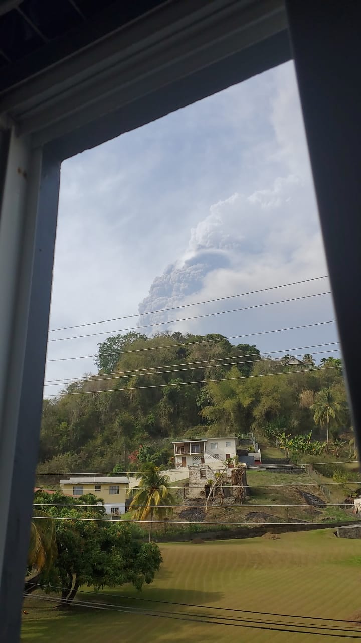
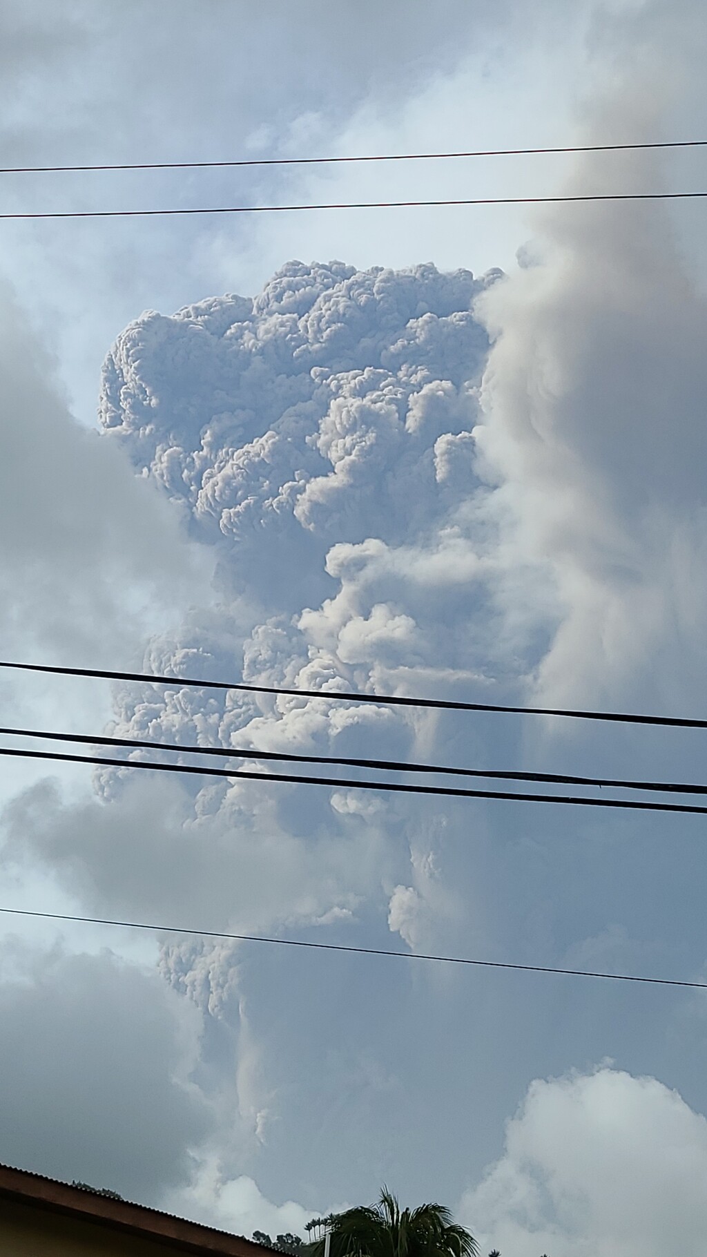
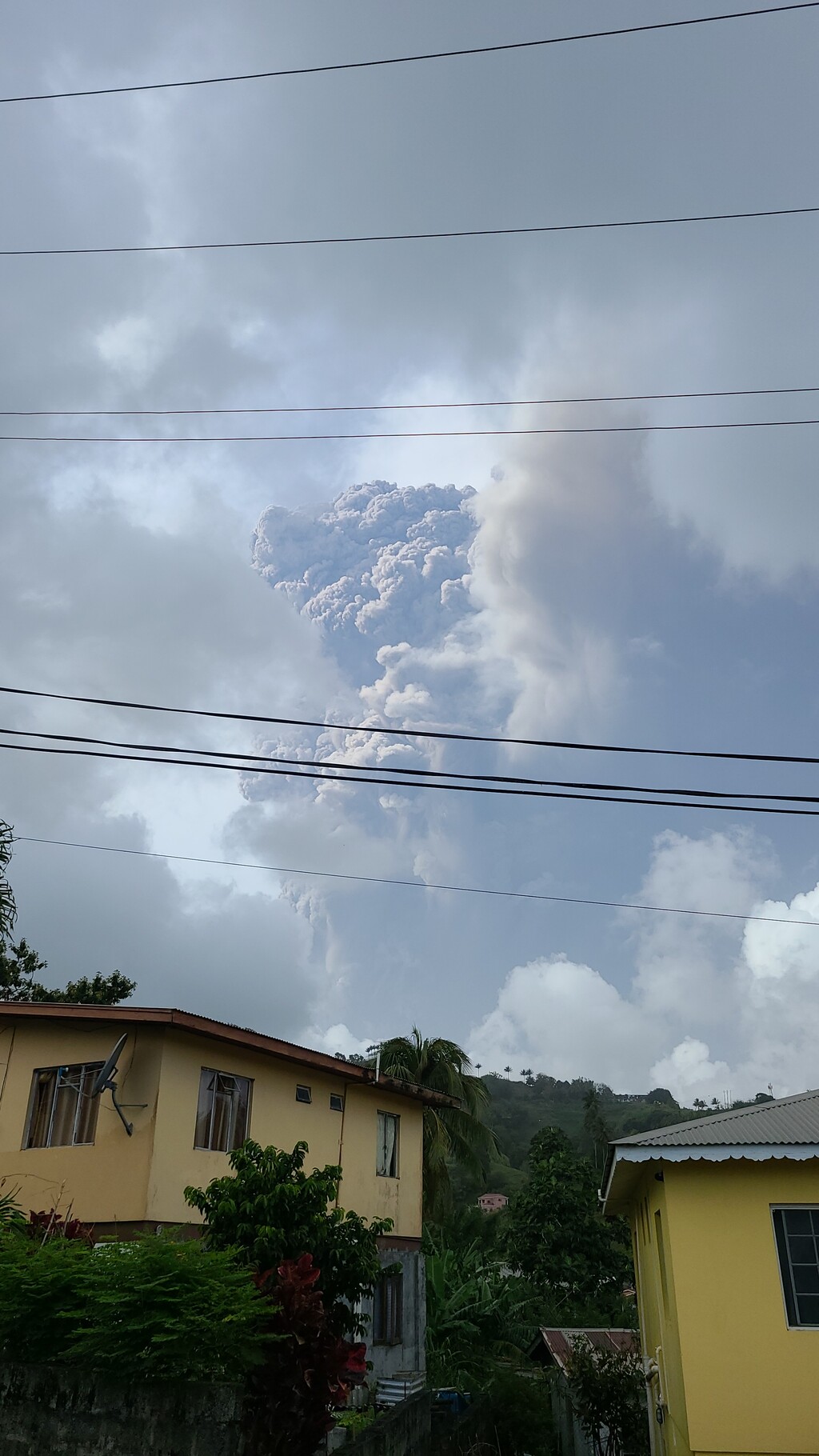
3. The episodes continue to coincide with periods of enhanced

venting or explosive activity

4. A reconnaissance of the entire north coast of St. Vincent from

Chateaubelair to Georgetown with assistance from the Coast

Guard.

5. Observations made indicate that pyroclastic density currents

(PDCs) had descended several valleys on the southern and

western flanks of the volcano and had reached the sea at Morne

Ronde, Larikai and Trois Loupes Bay.

6. Extensive damage to vegetation was noted in an area extending

from Larikai Bay to Turner Bay on the west coast.

7. No other areas along the coast had been affected by PDCs but

villages located on the eastern flank of the volcano had been

affected by heavy ashfall.

8. Explosions and accompanying ashfall, of similar or larger

magnitude, are likely to continue to occur over the next few days

with the chance of PDCs occurring.

9. Visit the International Volcanic Hazard Health Network for

volcanic ash information resources: www.ivhhn.org/information10


Virus-free. www.avast.com

- La Soufriere Volcano continues to erupt
  • By <cabana at vincysurf.com>
  • Date: Tue, 13 Apr 2021 11:47:56 -0400

Monday, there was a huge eruption in the early morning with pyroclastic flows of ash down through a several valleys, Larikai, Walliabou, and Rabacca, on the  lee side of St. Vincent.  A video was taken Monday morning of the ash flow reaching the sea at Larikai.  The pyroclastic flows bulldoze everything in their way, they move at 200 mph and the temperature is anywhere from 200 – 700 degrees.  Boaters are directed to stay well out to sea as the ash continues out across the water, it doesn’t just stop at the sea.


The old dome from 1979, and the newer dome that formed from the end of December and kept growing, are completely gone and there is a new vent in the top of the volcano.  Some people in the north have still not evacuated which was their choice but they are endangering the Coast Guard and fishermen who are trying to get out the ones who have decided they now want to leave.


There were 2 smaller eruptions through the day yesterday.  Another big eruption this morning, Tuesday around 6 am. 


Fresh water is a huge problem as the drinking water in St. Vincent comes from the rivers which are full of ash.  In Bequia where I live, many people just have small water tanks and they are in need of water as well.  People in Bequia can get water from the desalination plant in Paget Farm, up to 20 gallons per family per day.


Virus-free. www.avast.com

- Fwd:
  • By Gert van Dijken <gert at vandijken.com>
  • Date: Fri, 9 Apr 2021 15:20:06 -0700
I received the following pictures from Jr.
--
Gert van Dijken
Caribbean Hurricane Network
https://stormcarib.com  

JPEG image

JPEG image

JPEG image


- La Soufriere Volcano St Vincent, erupting
  • By "Cabana Bequia" <cabanabequia at gmail.com>
  • Date: Fri, 9 Apr 2021 12:43:06 -0400

About 8:40 this morning, Friday April 9th, La Soufriere erupted sending an ash cloud up 8km. 


La Soufriere has been rumbling since the end of December 2020, with a new dome forming on the side of the old dome that formed in 1979 inside the caldera, and it’s been growing steadily since then, so people have had lots of warning to be prepared to evacuate, with the volcano experts saying that they anticipated advance notice.  Yesterdays activity with the heavy steam and the reports of the magma rising inside and the earthquakes was that advance notice.


Due to the heavy venting yesterday, the area (red zone) closest to the volcano, at the north end of St Vincent was evacuated.  Today with the eruption, the Orange zone is being evacuated due to the ash fall which is like gritty sand in texture and contains small bits of stone.  The cloud plume of ash is going to the east, but there is ash fall on the mainland St. Vincent with reports of ash at the Argyle International Airport.


Currently the evacuated people are in government shelters or with family and friends.  Cruise ships have arrived to transport people that wish to go to Barbados, where they can shelter.  As well, Grenada, St. Lucia and Antigua have offered up shelters, and presumably the cruise ships would take people to those islands.


There are photos, videos and information available on the Facebook pages for I Witness News, The Searchlight, and NEMO St. Vincent and the Grenadines.


With the heavy steaming of the volcano yesterday, Thursday, April 8th, and the associated earthquakes, everybody started scrambling to disconnect their downspouts to their house water tanks, and sealing up houses in case of ash fall.  Today, with the active eruption, more scrambling to finish preparations.


My husband is working in Kingstown today and he says it’s a zoo over there with everybody scrambling to stock up on supplies.  I imagine Port Elizabeth is the same, though I haven’t been into the harbor yet so I don’t know for certain.


Challenging times with so few Vincentians being vaccinated, and not bothering to wear masks or take the Coronavirus seriously, so it’s going to be interesting to see where the numbers go for active cases in the coming weeks.


Virus-free. www.avast.com

- Stormlike Conditions experienced in some parts of St Vincent and the Grenadines Yesterday
  • By "Colvin \"Koolkidd\" Harry. " <colvinharry at yahoo.co.uk>
  • Date: Fri, 30 Oct 2020 14:19:25 +0000 (UTC)
Greetings All,


Just reporting on what transpired last evening here in SVG weather-wise. Thanks for what is now Invest 96L we had a generous amount of rain yesterday but after 6PM is when most of the effects were felt.Between 6PM yesterday and 6AM this morning over 3 inches of rain  was recorded by the met office at the Argyle International Airport.

The head of the meteorological Services in SVG Mr. Billy Jeffers called in on NBC Radio with information on rainfall and wind effect. According to him , the wind gusts were over 40 miles per hour.

NEMO or local disaster agency has reported damage in several communities including landslides and loss of roofs.A damage assessment team will meet this morning at 11:30am.


Here is the official information from them released late last night: 

Several house roofs have been damaged from strong winds in Hadleys Village, New Grounds, Adelphi, Akers, New Prospect/Simon, Peruvian Vale, Cedars and Spring-Biabou.
Several homes have also been damaged by fallen trees in New Prospect and Hopewell.
Many communities are experiencing gusty winds and St. Vincent and the Grenadines remain under a Flash Flood Warning.
 

Presently, it is cloudy in Kingstown with periodic moderate to heavy showers and a gentle breeze from time to time.

A Flood warning remains in place until 12 Noon today. I will provide another update later today if it is necessary.


Colvin " Koolkidd" Harry
Programme Manager
National Broadcasting Corporation of St Vincent and the Grenadines
Personal Mobile (Digicel): 784-530-9864 (WhatsApp Enabled)
Work Mobile (FLOW) : 784-494-7056
View my Weather Station at Green Hill for live Data at : http://www.svgweather.com/livedata 


Back to top | home | satellite | tools | pleas for help | QHWRN | guide | climatology | archive