 |
Caribbean Hurricane Network
- 2 0 2 2 Season - |
|
|
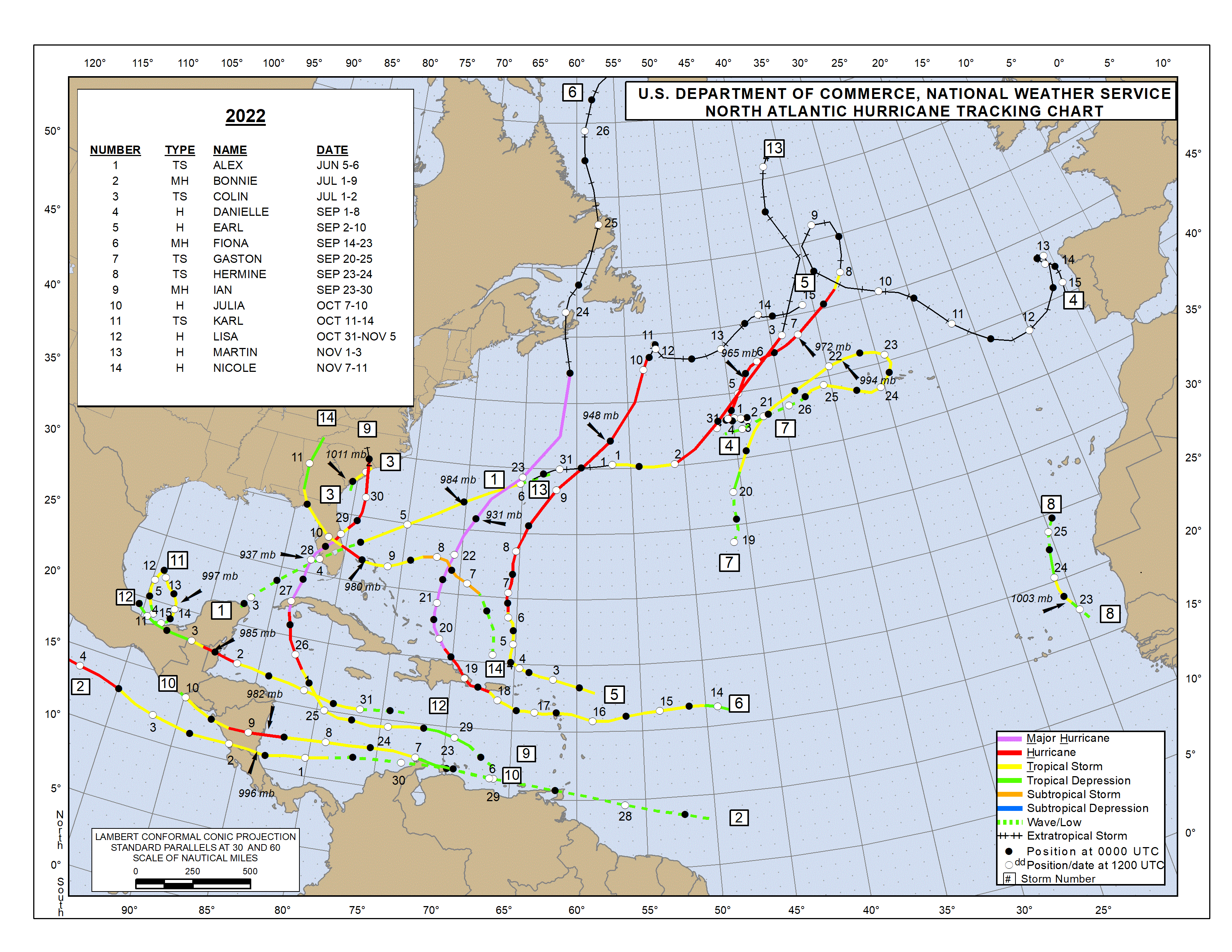
| 2022 Atlantic Hurricane Season |
| | Alex | Bonnie | Colin | Danielle | Earl | Fiona | Gaston | Hermine | Ian | Julia | Karl | Lisa | Martin | Nicole | Owen | Paula | Richard | Shary | Tobias | Virginie | Walter | |
Below links to local reports from the special hurricane correspondents on the islands:
Following is an archive of all weather discussions Dave and I posted. They are in reverse chronological order, with the most recent storm discussion on top. If you want more background in formation on specific storms, I have found the 2022 Atlantic Hurricane Season section in the Wikipedia a great resource. Also, visit the National Hurricane Center's website for 'best track' data of all 2022 storms. The track map below is from that website as well.
Weather discussions by Gert & Dave during the 2020 Atlantic Hurricane Season. The homepage with the links to local reports from the islands, latest satellite image, current weather outlook can be found here.
Sunday, December 25, 2022 08:54AM EST
- The season
-
Good morning all and Seasons Greetings!!
As we come to the end of 2022 we have much to be thankful for in our lives on this planet. I just wanted to take a moment and thank you all, our stormcarib family, for the participation, curiosity, interest and helpfulness that you all contribute. As an all volunteer network, Gert has brought together our weather community to hopefully inform, help, and protect our Caribbean.
May God or whoever you worship, look over and guide you as we enter 2023 shortly and enjoy with your family and friends this holiday season.
Merry Christmas!
Dave
Friday, December 2, 2022 20:17PM EST
- End 2022?
-
Good evening,
The end of the official 2022 hurricane season has come to a swift end as will the year in general shortly. Hurricane's Ian and Nicole decided to visit Mickey and Shamu (which included visiting myself on the east coast) in Florida while the Caribbean endured the wrath of Hurricane Fiona. Overall the tally was 14 named storms, 8 hurricanes of which 2 were majors; Ian and Fiona. Several systems visited Central America with Hurricane Julia being the wicked witch of the western Caribbean and Central America with Hurricane Lisa close behind. An average year, with way less activity than forecast, but nonetheless, destructive, damaging and deadly.
We might have one more spin up as we have seen in recent years in the mid Atlantic in a week or so but chances are slim but slim is not none. Regardless, if it does manifest itself, it will be the end and a fish storm unless the Azores get in the way.
Happy and safe holidays to everyone!
Dave
Sunday, November 6, 2022 11:26AM EST
- Nicole? Owen?
-
Good afternoon,
After a zero August, nasty Hurricane Ian in September, and evil Julia in October, November is trying to make up ground and pad the tropical system stats before the end comes. Two hurricanes at the same time in November, Lisa battering Belize and Martin, the farthest north hurricane ever in November made history. Now we have 2 more potentials to discuss. One, a fish storm 97L, east of the Bahamas will menace only the fish, shipping and eventually the UK and Europe bringing some good welcome rains to that parched continent. The other is 98L, poised to consolidate it's broadness into a potential TS down the road with the SE coast of the US in it's long range sights with a right turn Clyde possibility. The race is on to see who gets the next name, Nicole. Owen is after that.
98L, whose potential I shared at the end of my post last Tuesday, has dumped more than 5 inches of rain on the Virgin Islands between Friday and Saturday night with isolated amounts higher in Puerto Rico. Flood advisories have been up since Thursday as our grounds and PR's were already saturated. The tropical low was located earlier this morning right over the USVI on it's way northbound but had rained itself out before it's overhead arrival. Now about 130 miles to the north of Puerto Rico, it is trying to consolidate on it's way to visit the northern Dominican Republic, Turks and Caicos, the Bahamas and eventually the SE coast of Florida and maybe Georgia. It will take some time for this to happen due to it's broadness and the deep dip in the jetstream will not allow rapid intensification. However, light wind shear and bathwater SST's should allow for some intensification. Just how much remains to be seen. It is possible it doesn't intensify and plows into Florida a large, wet blob of moisture, unusual for a usually dry November there. Then, on the other side of the scale, we could be looking at a mid grade TS landing anywhere along the east coast, crossing the peninsula, and then, right turning, strike the west coast, cross the peninsula again, and head up the east coast towards NE.
Either way, the northern Caribbean and SE coast of the US will be the recipients of copious amounts of rainfall, coastal erosion, bad rip currents, and gusty winds. Parts of the central Florida east coast still have major erosion from Ian's exit plus the St. Johns river, still in flood stage from Ian will rise again if this holds true. Not pretty.
It's not over till it's over! Stay safe and prepared.
Dave.
Tuesday, November 1, 2022 19:13PM EDT
- Soon Hurricane Lisa
-
Good evening all.
A quick note as my time is limited at the moment.
Bottom line on soon to be Hurricane Lisa is she will be bashing the Bay Islands of Honduras tomorrow afternoon as a strengthening hurricane while approaching the entire coast of Belize as a probable Cat 2 with an attitude due to no wind shear and beautiful warm fueled waters. A Cat 3 at landfall is not out of the question as well. Belize City and southern cities are basically at sea level so storm surge will be monumentous flood wise however the sea walls and the world famous reef of Belize may protect them to a point. Sadly that same reef will suffer tremendous damage in doing so. Guatemala, the northern coast of Honduras, and parts of the Yucatan will experience heavy rains and possible flooding as well. Jamaica and the Caymans will experience sea swells as she speeds by. Even at 15 mph, she will still cause flash floods, land/mudslides, copious rainfall, and probable fatalities.
However, even though expected to slow down a bit, the longer time she spends over water headed into Belize without land interaction from Honduras, allows for that possibility of strengthening to Cat 2 maybe even Cat 3 minimal at landfall. Bad scenario nonetheless on an incoming, strengthening landfalling hurricane.
Once landfall is made, an opportunity, albeit small, will remain for this system to reinvent herself curving northeast into the Bay of Campeche and then from there, alive in the Gulf of Mexico, who knows. Not out of the realm of possibility but still possible. Then again, she could just die out or rejuvenate in the eastern Pacific. Too early to tell at this moment but all cards are on the table.
Sea level Belize coastline and cities, Lisa is not something to dismiss. Take heed. Evacuate to higher storm surge proof ground. The reef will protect to a point but your major coast cities are at sea level. 4-6 ft storm surge will be devastating and fatalistic. If she is incoming as a strengthening Cat 2 or more, then it will be worse for wear. But you will have hopefully evacuated.
TS Martin, newly found in the northern Atlantic all alone with no land masses to menace, is expected to reach Cat 1 hurricane status briefly before transforming into a strong extra tropical force headed to the UK and Ireland. A fish storm extraordinaire far north in 82 degree waters, Martin is making the best of what he can be short lived as he will be name wise. Headed to Europe eventually, he might have enough energy left to dump some copious rains on a parched European continent after menacing the UK.
Elsewhere, the MDR is ravaged by hostile wind shear with limited activity tropical wave wise. The possibility does exist in 5-8 days that a cut off low from the jet stream will drop down by the northern Caribbean above PR and the Virgin Islands with a copious rainfall intent for a few wandering days. Then, maybe, transforming into something tropical as it reverses course back towards the mainland. Time will tell.
Stay safe and prepared. Belize get ready.
Dave
Tuesday, November 1, 2022 11:04AM PDT - Two storms
- Maybe I did jinx it yesterday... A new storm has formed in the Atlantic, Martin, now located over 500 miles to the east-northeast of Bermuda. It is not expected to be any threat to land. It is quite unusual though to have 2 tropical storms at the same time in November. Phil Klotzbach (Colorado State) tweeted that this is only the third time that it happened (in the satellite era, so it might have happened before but didn't noticed it...). Other years were 2001 and 2020 (2x even).
Meanwhile Lisa is still going west towards Belize. The track has unchanged, but it is expected to become a hurricane sooner than earlier forecasted. Sea water temperature is high enough for speedier development, but the presence of dry air is inhibiting strengthening. Hope that holds true! Stay safe. -Gert
Monday, October 31, 2022 09:47AM PDT - Lisa
- The Invest Dave was talking about on Saturday has been upgraded to Tropical Storm Lisa. It developed just south of Jamaica and tropical storm watches have been issued for that island. Tropical storm watches have been discontinued for the Caymans. Lisa doesn't look like much on the satellite image and it is not expected to get much stronger. It is traveling west, and is expected to make landfall in Belize Wednesday. Right now it might be just minimal hurricane strength by that time, but a lot can change in direction and development before that...
Lisa is 'only' the twelfth tropical storm of the year. According to Brian McNoldy This season is only 73% of average so far (in terms of total 'energy'). Much better than the above average season forecasted in June. (Hope I don't jinx it now...). There is also a very good Lisa discussion by Jeff Masters at Yale Climate Connections. -Gert
Saturday, October 29, 2022 13:48PM EDT
- 95L
-
Good afternoon,
North of South America but close enough to affect the ABC Islands, Venezuela and a few islands belonging to Columbia, 95L is also spewing moisture northwards to PR and the Virgin Islands while continuing a West to WNW trek across the Eastern into the Central Caribbean. For a change, courtesy of the lingering front the last few days, PR and the VI's don't need any more rainfall. In fact, flooding has occurred in the northern Antilles from this deluge of non tropical storm formation. PR especially, does not need any more water.
The deal with this Juilaesque system, aka 95L, is latitude. The farther south it stays, the better chance of reaching strong tropical storm status and maybe a hurricane before plowing into Central America like Julia. The farther north it treks, closer to Jamaica down the road, wind shear will deal it a severe blow and we might not have a hurricane or even strong tropical storm, rather a strong gusty rain producing open wave. It's rather large, spread out size is also a hindrance to development although thunderstorms have tried to consolidate around the low pressure center. Right now, not impressive by any means but Jamaica and the Caymans should be on alert as well as Honduras, Guatemala, and Mexico. Late season storm so could slide under the steering current to the north too. Just a possibility.
Elsewhere a slight, short possibility in the Atlantic a few hundred miles WNW of Bermuda which should not develop as it will encounter a front plus hostile wind shear. In the MDR, wind shear is just too nasty for anything to develop in the short term.
Things appear to be winding down but a few late spin ups of the homegrown variety are likely the next 33 day of the official season. No time to be complacent, just stay informed and vigilant.
Stay safe and prepared!
Dave
Thursday, October 6, 2022 22:31PM EDT
- Bye Bye 12, Hello Julia
-
Good evening,
TD #12 is still lingering in the east central Atlantic heading WNW with an expected turn to the west, falling apart by tonight as ferocious wind shear has taken its toll. Maybe it survives till the morning as #12 but I doubt it. Down the line, in a few days, slight potential exists of regeneration. This season is weird enough already and this scenario would fit in perfectly. Time will tell.
TD #13, on the other hand, is quickly making a beeline for Central America, steered by a very strong high pressure ridge. This low rider of a hot mess of a storm has been doing battle with its close proximity to land but within 12 hours, maybe sooner, TS Julia may be hatched as she finally pulls far enough away from South America, the ABC Islands, and several other smaller islands. Normally dry, the ABC Islands are expecting several inches of very welcome but possibly flooding rains and windy conditions which they are unaccustomed to at their low latitude late this weekend into Monday. Down the road as a hurricane, Julia will not be judicious as she will pummel Nicaragua, Panama, Costa Rica, Honduras and those along her way with flash flooding, heavy rains, mudslides, and the omnipresent storm surge. Mexico will also feel her diminishing but expanding dissipitating wrath. Hurricane hunters are investigating to see if her consolidation is reaching TD or TS status.
Forecast to be a strong Cat 1 at landfall, I believe, with the warmer waters that stretch deeply that hurricane Ian missed since he recurved before inhaling that energy that remains and low wind shear with a moist atmosphere, future Julia could strengthen to a Cat 2 and even a Cat 3 if she slows down since forward speed is now 17 mph due west. This would increase the threats and potential devastation ahead.
Recurvature and regeneration after a Mexican encounter has been floated but that is not probable, just possible. Time will tell with that depending on a trough expected to come down from Canada. Timing and location is everything when Mother Nature's global effects collide.
Off the African continent will be a few potent low rider tropical waves over the next week splashing down but ahead of them is quite a late season blob of Saharan Dust whose tentacles stretch below 10N. This, if it maintains, will prohibit any short term development but we still have 2 months of official season to deal with, the dust could lift north and the low rider season continues.
Stay safe, prepared and Central America, get ready as even if this system can't clear land fast enough and arrives as a strong TS, a weak Cat 1, or even an open strong discombobulated wave mess, the effects will be widespread and potentially disastrous..
Dave
Wednesday, October 5, 2022 05:35AM EDT
- Lowrider season continues
-
Good morning,
Quick note before work this morning. Hope all is well as can be after Fiona and Ian jolted an otherwise very quiet season with Puerto Rico, the DR, Turks & Caicos and Florida getting hammered while the southern Windward Islands and the ABC Islands received unwelcome rare attention as well. In the next few days, the ABC's and southern Windwards look to get another heavy dose of rare attention from 91L which is following the low rider route trending this season.
TD#12 is an ugly tropical depression out in the Eastern Atlantic but should not affect any land masses as it moves NW into the central Atlantic. Expected to be short lived and dissipate by Friday due to cooler sea surface temperatures and much higher wind shear, this system has a small chance of regeneration after 5-7 days while moving towards the sub tropical Atlantic, again not expected to be a land mass threat.
91L will menace the Windward Islands, ABC Islands, and the northern coast of South America on it's way to what possibly could be a bad encounter with Nicaragua, Honduras and Belize. Not expected to recurve like Ian did due to strong high pressure steering, squally weather with heavy rainfall is expected over a wide area. If it can avoid too much land interaction, 91L is likely to become a depression and intensify into our next hurricane. Hurricane Hunters are expected to investigate very shortly.
More later. Stay safe and prepared.
Dave
Monday, October 3, 2022 20:04PM PDT - Wave way south
- A tropical wave is approaching the Lesser Antilles. Now named Invest 91L is not expected to become anything before it crossses the islands late Wednesday, but it will bring some 'squally' weather. So stay alert!
Another tropical wave further to the east, Invest 92L, might actually become something. The NHC gives it a 70% chance to become a depression within 48 hours. However, it should veer well to the north before reaching the islands. Stay safe everybody! -Gert
Thursday, September 29, 2022 13:51PM PDT - Ian
- I am back home again from vacation and family visit in Europe, so ready to report again! Thanks to Dave for holding the fort with his excellent contributions! They are the best! A lot has happened in the 3 weeks I was gone: when I left we were dealing with Earl, there has been a few storms since. Glad that Ian passed safely around the Caymans, but sad to see the destruction in Florida where it made landfall as a Category 4 close to Ft.Myers (and poised to make another landfall near Charleston, South Carolina).
Elsewhere in the Caribbean I see this big blob in the eastern Caribbean Sea, but that's not expected to become anything. Tropical Depression 11 that is 'way out' there is basically gone. However, a new tropical wave has departed the African Coast and may develop into something, but it looks like that it will veer off to the north before it reaches us!
Finally, thanks for all the donations I have received so far. I am still in the process of thanking you personally (I am 'a bit' behind on email). Also I wanted to note that I added another payment option, Stripe, for people who can't or won't use Paypal. Stay safe everybody! -Gert
Monday, September 26, 2022 13:12PM EDT
- Ian and the 3 Ex's
-
Good afternoon, time for a lunchtime update.
After a huge burst of tropical activity which saw Hurricane Fiona whose name should be retired after the death, damage and destruction she caused from Guadeloupe all the way north through Atlantic Canada even affecting Greenland, TS Gaston, a survivor of sorts, and TS Hermine, a rare short lived bird to say the least due to her rarer appearance so close and north to the west coast of Africa, there now remain only two. The above are now Ex's while 99L survives and Hurricane Ian is thriving and driving.
99L is still meandering in the central Atlantic, should reach TS named status and might even become a minimal short lived hurricane while remaining a wanderer with no land mass to menace. Most bets say Julia, the next name on the list, will be a fish storm of mid to strong TS status moving mostly northeast and fizzling out over the open waters.
Unfortunately, there is no fizzling expected of Ian anytime soon and while he's driving towards the western tip of Cuba, he is thriving quite nicely in the bath waters west of the Caymans which to this point is "weathering" Cat 1 Ian handily. Some dry slotted air has been ingested by Ian into his central core unexpectedly which is slowing that thriving but that appears now to be close to walled off so it's on for more rapid intensification. High surf generating rip currents and coastal flooding/surge will propagate to the Yucatan Peninsula, Honduras and Belize and eventually the Florida coastline and Keys. Crashing into Cuba's hilly, not mountainous western end, which Ian will not loiter over for very long as a probable Cat 3, he will then start to menace the western coast of Florida having already started his shenanigans with the Florida Keys. Due to the girth of this system, beginning effects will be felt in the Keys and SW Florida tomorrow morning with tropical storm force winds stretching out 115 miles while being on the "dirty" side of the storm.
From then on, uncertainty remains as to where the direct impact will take place but most takes are between the Anclote River and Englewood at this moment. This is not cut in stone as wobbles east, north and west will occur since no storm goes in a direct straight line for extended times. A little wobble east means worse conditions while west would lessen. Regardless this is going to be a surge of massive proportions if 15-20 ft of water are pushed up into Tampa Bay and the others along the coast. Even McDill AFB could be affected by flooding. This is just at the coastline. Heavy rain and flooding is lurking for the central and northern regions of the state until he pulls away.
Clarity will manifest itself in regards to landfall and potential impacts after Ian's interaction with Cuba but for now, the west coast of Florida, especially the central part, should be thinking evacuations from the coastal areas and flood zones. Ian is large, who will affect most of the peninsula, in charge, and bound to make a destructive statement, not only wind wise, but also for flooding and rainfall. There's a slight chance too that the trough actually misses Ian's bus stop leaving him to stall a few days at Disney while dumping 20+ inches of heavy rainfall. Slight but possible.
Georgia, the Carolinas and all up the east coast should feel his remnants down the road but that's for another future discussion. Hopefully he jogs a bit more west and his proximity to the coast will somewhat lessen his destructive drive but right now, that's not promising.
Stay safe and prepared! Evacuate voluntarily while you can and definitely if mandatorily issued. Don't put yourselves and first responders lives in danger by being selfish and/or stubborn. Mother Nature says Yes, it can happen to you.
Dave.
Friday, September 23, 2022 20:55PM EDT
- Ruh Roh! The Dreaded "I"
-
Good evening,
This is much later than I wanted to post but I had to make some preliminary hurricane preparations on the domestic front. Instead of preparing for a US Virgin Islands storm, I'm planning on a Florida not so sunny visit next Tues/Wednesday. At least I have no towel brigade to deploy for this one as no leaks in the premises here. Thank you to my neighbors for their help as well.
First, Fiona, still rampaging across the Atlantic, on a potentially historic damaging visit to Atlantic Canada aka Labrador, Newfoundland and Nova Scotia. Having reemerged as a Cat 4 briefly north of Bermuda and now trucking along at 46 mph as a Cat 3, Fiona will slow down and pack a monstrous punch as a Cat 2 or more probable Cat 1 with huge waves, storm surge, and heavy rainfall. The amount of water she will be pushing is enormous. Surely, Fiona looks to join the retired name list after her, at the end of the day, several weeks long shenanigans. Bermuda was very lucky by the way as she made an unexpected long hard right just north of the island. If that had been 1/2 day before, Cat 4 would have been up close and too personal.
TS Gaston has also done something unexpected as in visiting the western and central Azores, something he was supposed to avoid and turn NW beforehand. After this unwelcome deviance from what was expected, Gaston will head back west and get torn apart in about a day and a half. Supposedly. I guess Gaston can no longer be thought of as a "fish storm".
99L is still hanging out in the mid central MDR and expected to truck to the NW potentially reaching named status and appears to be a true fish storm in the end. This season has not been normal so we shall see what the end result will be with this system.
The disturbance between the African coast and the Cabo Verde islands has beaten former 98L to the name game and taken Hermine for its own. A strong rain threat to the Canary Islands, Hermine will not live long but will be known as the usurper who took the H before the dreaded I. My personal "I" was Irma in the USVI, 2017. No "I" storm compares in my book/experience.
Now the "I" is the most retired letter of all named storms since 1953 with 11. The last nine are since 2001. Our next one is Ian and I believe he might join that list. Still TD#9, soon to be Ians center is still lagging behind the ball of convection ahead of it due to wind shear from hurricane Fiona way up in the North Atlantic but that is expected to be left behind as Fiona continues to pull away and TD#9 trucks WNW then W. Once the shear lessens and this system hits ultra warm bathwater in the central/western Caribbean, rapid intensification is not just expected, its explicitly expected by the NHC. Explicitly is rarely used and shows the confidence in the models plus the lessons learned over the last decade or 2. This bodes evil going forward. Jamaica is first up with the south and western ends expected to get the worst of a rapidly strengthening tropical storm. The Cayman Islands will then feel a strengthening Cat 1-2 hurricane with the Isle of Man and the flat western end of Cuba next. I mention flat as there are no mountains there to tamp down future Ians wrath. Entering the Gulf of Mexico as a probable still Cat 2 visiting closely Key West, further bathwater and low shear should enhance Ian's structure into a formidable Cat 3 approaching Florida's west coast.
Too soon to tell exactly where US landfall occurs and where is the big question at the moment. Keys to the Panhandle should be on alert. It all depends on the high pressure over the gulf moving westward and the trough coming down from the north as to where potential Ian will curve. He might even jog further west in the Caribbean before turning. Lots of variables are still in play and nothing is certain so preparations and diligence should be in play regardless of the path and the cone is not always the true path.
Up the road another landfall is possible as some models are long casting through NC and due north after that. Time will tell for sure as that's far out for now.
Stay safe and prepared. This might be a rough ride, more expected than Fiona's and potentially more deadly and dangerous once said and done.
Dave.
Wednesday, September 21, 2022 12:39PM EDT
- Menacing September
-
Good afternoon for the lunch update,
The current Diva" of the tropics, Cat 4 Hurricane Fiona, is muddling along at a paltry 8 mph clip northward, on a date to pass by Bermuda late Thursday into Friday, pick up some good forward speed and slam into Atlantic Canada as a historically ferocious, non winter and transitioned, non tropical monster.
Likely to retain her Cat 4 status for the next say 60 hours, eyewall replacement cycles will probably inhibit her attempts at a short lived Cat 5 life plus some wind shear is still pestering her all along her path until the trough picks her up. Her effects on Bermuda will be some tropical storm force winds, high seas and surf, coastal erosion, sporadic loss of power and isolated flooding from storm surge and those rough seas. This is contingent of Fiona following directions and staying the course. Any wobble to the east upon approach to Bermuda will antagonize these effects higher. Her effect on the east coast of the US will be rough surf and seas plus an increase in deadly rip current risk. Her effects on Atlantic Canada could be of historic damaging proportions.
Fiona is also having an effect on another system far down by Trinidad/Tobago in the southern Windward Islands but second up, we have TS Gaston, a current ship and fish storm moving to the NE at 16 mph with 65 mph winds. A small, compact storm, he might make minimal hurricane status but that will be short lived at best. Expected to keep more east then do a left turn Clyde, Gaston will remain in the open Northern Atlantic and pose no land threat. The western Azores could see high surf and rougher seas around but that should be the extent of it.
Now, Fiona's far reaching effect on 98L is in the form of northerly wind shear from her outflow. This is helping to keep 98L from getting anything going more rapidly and stronger although the low level circulation seems to be thriving. Winds are estimated at 35 mph but a closed circulation has not been verified as of yet. Heavy rainfall, rough seas and gusty, squally winds are already taking place and while not looking pretty on satellite at this time, it is expected to consolidate soon and become a TD then a TS shortly thereafter. Hurricane Hunters are expected to fly into 98L with an early evening mission and then another early tomorrow morning. Fiona's outflow will have dissipated and will no longer be a threat to 98L and this should allow TD status to be achieved. So, will 98L become Hermine or will one of the 2 waves behind it make it to Hermine first, thus making 98L the potential "I" name, the most disastrous and feared letter in hurricane name history? It will be Ian if so.
While too early to tell after 5 days where 98L and it's future namesake will go, although all points to a panhandle/west coast of Florida landfall (Tampa shield watch out), the next five days will be a slow developing system to TS status through a historical graveyard of the tropics on the way to visiting Jamaica, the Caymans, Cuba, and maybe the Yucatan before making a recurve to a potential tropical bomb in the Gulf of Mexico. Yes, it is very possible. What will slow 98L right now is recovery from Fiona's outflow, and it's continued close interaction with the South American coast which will have an effect on it's future track as well, more south and west. We shall see but this has bad potential juju once past 70W.
WSW of the Cabo Verde Islands is the next low riding contender dealing with some dry air but overall expected to slowly develop as well while moving WNW then shoved west by the dominant high in the Atlantic. Another one to watch warily. This one will probably make 99L first but if not, the one splashing down off the coast of Africa tomorrow at some point will. That one will be only a pain to the Cabo Verde Islands and Western Africa in an area few develop anything due to the pervasive saharan dust flow.
So, Fiona will still cause havoc on her way poleward, Gaston will continue to catch fish, and 98L, even in it's infancy, is drawing widespread attention already and the potential havoc and devastation it could cause. A literal reign of terror amok in the Gulf. Let's pray this or any other terror from 98L does not manifest itself. Guadeloupe, Puerto Rico, the DR and the Turks/Caicos, we have seen enough already.
Stay safe and prepared!
Dave
Monday, September 19, 2022 14:11PM EDT
- Maria's niece, Fiona
-
Good afternoon,
Category 1 Hurricane Fiona is now back over water north of the Dominican Republic on her way to a close encounter with Grand Turk and the rest of the Turks and Caicos while also expected to menace the easternmost southern Bahamas. The T&C are very low lying so storm surge and coastal flooding could become problematic. This does not mean the misery is over yet for the DR nor Puerto Rico which took the brunt of Fiona's quickly galvanized fury, not so much wind wise although there was significant damage in some areas, but the scope of torrential rainfall, flooding and mudslides. This scope rivaled and continues to exceed her Aunt Maria's rainfall totals almost 5 years ago to the day, even taking out a newly constructed bridge first taken by Maria's floodwaters, plus, like Maria, the whole island was out of power at one point. After today, hopefully after the tail flashes by with a final bang, cleanup can begin in earnest and power more quickly restored than with Maria. Maria claimed over 3000 lives that were verified and many more unaccounted for. Fiona has been kinder in that area. For the DR, the flooding is not as extensive but homes and hotels have been damaged, the power grid is damaged and fluctuating, cell service spotty all while Fiona is still pounding away at the Samana Peninsula as she pulls away from the E and NE part of the country where tourist areas abound. Sadly another fatality has been reported.
After moving farther west than anticipated, putting the T&C too close for comfort to Fiona's wrath, Fiona is expected to ramp up to the seasons first major upon approach to Bermuda as wind shear, while moderate, is expected to align up with the rotation and not against it while going over untapped very warm waters. A Cat 4 is possible but a high end Cat 3 is more like it. After a close fly by with the strongest side of the storm doing the interaction with Bermuda, or, even a direct hit at this point, Fiona will get picked up by a trough and speed on her way to a potentially damaging encounter with Newfoundland, East Labrador, Prince Edward Island and even east Quebec maybe. Too early to tell but she should still be a hurricane on approach to Canada.
While all eyes are on Fiona, we do have a few sleeper waves to mention, one which could impact Barbados, the southern Windwards, the Central Caribbean, the Yucatan and eventually emerge into the GOMEX. The year of the low rider continues. 97L, an exception to the low riders, is loitering around the central Atlantic and has a small window of opportunity to make a Gastonite of himself. That window will close quickly though and his remnants might affect the Azores down the road. Shipping and fish will most likely be his legacy.
One wave of interest is now on the western coast of Africa with good potential and low now but is expected to be drawn up north after splashdown, maybe get a quick spin up, then just as quickly die out as it moves towards the Iberian Peninsula.
The sneaky wave is now located close to 50W and 10N. The NHC just posted it as an area to watch although not an invest yet. The long term models are actually in modest agreement already that this might be a major player down the road through the east and central Caribbean. This does not bode well for Jamaica, The Yucatan, Cuba, the Caymans and eventually the Gulf of Mexico. Texas to Florida by the end of the month might be staring down a monster running amok in the gulf with nowhere to go but land. Again, this is a long term look at things but it is that time of year and there is a large reservoir of untapped hot water just waiting to fuel a willing, organized storm. Lake Charles has been a storm magnet as of late while the Tampa shield has been a force. Something to be aware of in the coming weeks. Significant organization and strengthening is not expected until it reaches 70-75W where wind shear values will plummet. For now, the outflow from Fiona should limit any quick development as it heads towards Barbados and the lower Windwards.
Speaking of Barbados, thank you to Jurgen on Barbados for his knowledgeable report contributions and his kind comments to me. I really appreciate it. All correspondents need a pat on the back once in a while so my pats go out to all of you! Thank you.
Stay safe and prepared. Looks like the back end of this hurricane season will not go quietly into the night. I think Fiona has paved the way for the ruckus to finally begin.
Dave
Sunday, September 18, 2022 13:50PM EDT
- Finally Fierce Fiona
-
Good afternoon,
Imitating uncle hurricane Earls footsteps, sloth like and meandering, now upgraded hurricane Fiona has finally managed to take advantage of weakening, though still evident windshear, and very warm SST's, the fuel for the hurricane engine. Able to stack up vertically at all levels, Fiona is a force to be reckoned with seriously. As a tropical storm, she has already dealt serious damage, injuries and fatalities to Guadeloupe plus a storm related death on Culebra at a storm shelter per one of our awesome storm volunteer correspondents which we are all willing volunteers on this site. Less damage but well needed rainfall was felt on the inbound by other Leeward Islands and the USVI as well but as usual, power outages abound with St. Croix receiving the brunt of it all due to proximity to the COC.
On a correction note from my last post, in my haste to post before late Saturday night dinner, I quoted my 270 and 280 degrees interpretation incorrectly and was advised of it. Thank you Jan B. I'm human and do make mistakes, boo. Appreciate the heads up!
Currently Fiona is at approx. 17.5N, 66.63W, 987 millibars pressure and moving WNW at 285 degrees back down to a slothy 8 mph which is about 50 miles SSW of Ponce PR on their southern coast and approx 123 miles SSW of San Juan. Eye Diameter revealed by the hurricane hunter mission 11 shows an eye 39 miles in diameter. Large but will shrink during intensification. Heavy rainfall and numerous power outages, about 700,000 according to LUMA and our correspondent in PR are occurring presently and previously with rainfall amounts in isolated mountainous areas expected to accumulate to 20+ inches. The flooding, land and mudslide potential is and will be enormous plus a 103 mph wind gust was very recently reported on the south side of PR by Ponce. The southern and western coasts of PR and east coast of the DR are in for a rough 24 hours with an intensifying Fiona on the rise. Fiona might just be a Cat 2 entering or in the Mona Passage.
Behind 200 miles to the east is a segment of Hurricane Fiona, the formidable tail so to speak but more like a ball this time, which will continue to lash the islands long after the center has exited the Eastern Caribbean. These lasting effects of Fiona will be for the next 36 hours or so in terms of heavy rain, rough surf, gusty winds, etc....
Looking past her trashing of southern and western Puerto Rico, Fiona's interaction with the eastern coast of the DR will be rainy and gusty but minimal compared to what she does to western Puerto Rico shooting the gap through the Mona Passage UNLESS she wobbles more westward which storms have a tendency to do: wobble in general not just westward. However, this will still not be the interaction with the mountainous terrain hoped for which would have disrupted Fiona's magnitude. The Turks and Caicos appear, on current track, to get a close brush while the southern Bahamas get a good breeze with high surf and way outerband rainfall. If the forecast holds true and Fiona does not make a leftward slip towards the east coast, then Bermuda, you could be in for a close encounter with the first major of the season, a Cat 3 or more probable 4 Fiona. Newfoundland, you could be next after Bermuda in about 6-7 days from now as a fierce Fiona slowly downgrades to a very strong extra tropical North Atlantic gale storm. We have seen far north unlikely systems already in the North Atlantic aka Danielle and even in the North Pacific which could affect Fiona down the road.
Prayers for those in the path and currently enduring an intensifying Fiona and hope all are prepared as best as they should be. For those who are not prepared, even more prayers. Some are still not recovered in PR from hurricane Maria 5 years ago.
Dave.
Friday, September 16, 2022 18:57PM EDT
- TS Fiona Looming
-
Good Friday evening,
This update will focus on the immediate trauma about to affect the Leeward Islands with the tail of Fiona affecting some of the Windward Islands as well since most of the convection of Fiona is to the east and south. We all know what the tail can bring, that lasting sting as it pulls away. I'll touch on the future after.
Currently, on the forecast track, Fiona is about to have an intimate interaction with northern Guadeloupe, only 235 miles ESE of St. Croix. Earlier, she was traveling at 270 degrees, south of due west, but now is moving 280 degrees or due west at 15 mph being guided by the strong high pressure in the Central Atlantic. So the little southerly shove is over and west then eventually WNW is expected to occur. Shear has lessened slightly, pressure has dropped a millibar, and the atmosphere has moistened a bit so it appears Fiona will strengthen slightly as she traverses the island chain with limited land interruption until she reaches the eastern coast of the DR Sunday night into Monday. At 50 mph with higher gusts plus TS winds stretching 140 miles outward to the north and east, TS warnings are up all over the northern islands and Puerto Rico with watches mainly south of Dominica and ahead to the west.
Main effects will be a drought busting, flood inducing, landslide creating in some areas, potentially dangerous rainfall, particularly east/south PR and the eastern DR. If she slows down a bit as predicted, that rainfall will be exacerbated. If she strengthens a bit as the hurricane hunters might find on their next mission, then winds might become exacerbated as well along with heavier rainfall. Guadeloupe's mountains might disrupt Fiona a tad depending on the finite track. After leaving there, passing south of St. Croix by about 35 miles late Saturday afternoon, she will drench eastern and southern Puerto Rico but not traverse the mountainous areas thereby keeping Fiona's strength up to par.
Down the road most models have Fiona turning across the less mountainous areas of the DR and approaching the Turks and Caicos plus southern Bahamas as a Cat 1 hurricane then potentially Bermuda comes into play. Well, a former typhoon in the northern Pacific might have a say in that as it could pull Fiona more northerly due to interaction with the jetstream. However, it's timing and as always, location, location, location. While most forecasts say NW, N, then NE after the T&C, Bahamas and Bermuda, Fiona could still slip under and move west to affect the east coast and/or the Gulf if not picked up by said trough or it breaks away from the ridge's steering. Then all bets are off. Yes, it's possible and slim but you have to be aware of all possibilities. These systems are subject to all sorts of dynamics and sometimes, do not conform to normalcy. Too early to predict at this time. Too bad TWC only goes to PR during these things. Never to the USVI. I know why but it's a moot point.
Stay safe, prepared and as dry as you can. Tonight and tomorrow are gonna be wet and rough Leewards.
Dave.
Thursday, September 15, 2022 12:50PM EDT
- TS Fiona
-
Good afternoon,
A lunch update on TS Fiona chugging rather haphazardly towards the Northern Leeward Islands where TS warnings are up for Antigua, Barbuda, St. Kitts, Nevis, Montserrat, Anguilla, Saba, St. Eustatius and St. Maarten. TS watches up for St. Martin (weird as they share the same large island but different governments), the butterfly island of Guadeloupe, and St. Barthelemy.
Moving just south of due west at 14 mph (16.6N 54.3W at 11 am) with a decrease in forward speed expected, Fiona is approx. 465 miles from the outermost Northern Leewards. Wind speeds are estimated at 50 mph with higher gusts but I suspect they are higher. Hurricane hunters will investigate this afternoon for the latest updated information as for now, it's satellite estimates and observations.
Fiona's low level circulation is far outrunning the large blob of convection behind it, preventing stacking the levels, as moderate wind shear is still inhibiting organization and strengthening. Plus a slug of dry air is leading the way and Fiona is ingesting some of that as well. Good thing or we would probably have a Cat 3 or higher headed our way. For now, those factors should keep Fiona from becoming a hurricane before passage through the islands but we've seen this scenario before. Fiona has been fighting dry air and shear and still plods on slowly consolidating. Wouldn't be surprised if she pulls a meteorological sleight of hand and fools all by making herself a hurricane. Slim odds yes. But......
All the usual effects of tropical storms are to be expected with Fiona. For the USVI, Port Condition X Ray has been implemented by the COTP, Sector San Juan, with Port Condition Zulu, effectively closing the seaports to all vessel traffic expected within 24 hours. 60 mph winds with higher gusts, heavy torrential rains, landslides, flooding, flying debris, power outages, high surf and coastal erosion are all anticipated. The drought will be over but this is not how we wanted it to happen.
After initial entry into the Caribbean there are a few different scenarios. If the ridge holds strong, Fiona will be steered more west, especially if a weak system still and will potentially menace Florida and even the gulf coast. First up though will be Hispaniola, Haiti, Turks and Caicos and the Bahamas. It could take a turn northwest if she gets stronger and a weakness in the ridge is exploited. It also could be pushed into the east coast courtesy of a trough pushing down from the mainland. Too early to tell at this moment. For now we are staring it down ourselves.
More later. Stay safe and prepare!
Dave
Tuesday, September 13, 2022 19:55PM EDT
- Slo Mo 96L
-
Good night all,
Just a quick update on the system about 900 miles to our east, 96L which must be related to the former hurricane known as Earl as it is doing its best sloth moving imitation making its way west at a paltry 6 mph.
Located approx. 15N 45W, 96L is surrounded on three sides by saharan dust and mid level dry air which is tamping down its efforts to consolidate and strengthen. Forecast originally to follow a path more closer to Earls, the models are showing a stronger mid Atlantic ridge forming which is going to force this weak system on a more westerly course. This puts it on a direct collision course, regardless of what it will arrive entity wise, with the mid to northern Leewards Friday into Saturday. This is subject to change as we all know but this is the scenario at the moment. Whether a strong open wave, a tropical depression or a mid level tropical storm, the main effects will be the same except a stronger storm means the more intense those effects. Those will be heavy rain with flooding potential and slides, especially due to the drought conditions of the past 8 months, high seas and surf, rip currents, sporadic power outages, and some wind damage if stronger with flying debris.
After passing through the Lesser Antilles over the weekend, Puerto Rico and the DR/Haiti aka Hispaniola will probably experience heavy rains and flooding due to the mountainous terrain and in Haiti's case, deforestation. If anything remains, it's anyone's guess as it could curve north or ramble into the Gulf of Mexico, not out of the realm of possibility. Too early to tell with its slow movement and non development at this time but definitely something to be wary of.
To the east, the wave by the Cabo Verde Islands appears to have lost its chance of development while several low riders, future eye brow raisers, are making their way to splashdown off the African coast. 1/2 of the season is over. The other 1/2 is on deck.
Stay safe and prepared!!
Dave
Thursday, September 8, 2022 22:16PM EDT
- Still going
-
Good evening,
Hurricane Earl, who took seemingly forever to cross the MDR and consolidate into something, is now poised to make a run at Bermuda while becoming the first major hurricane of this rather ping pong of a season. Hurricane watches and TS warnings are up for the well prepared and often in the crosshairs island. Earl is a Cat 2 while forecast to reach Cat 3 status but now not reach Cat 4 as dry air has unexpectedly entrained itself into the eye thereby disrupting what was once a quickly intensifying event. This results in an expanding windfield which puts Bermuda in a much closer encounter with Earl than wanted. At the moment, Earl is expected to pass about 75-100 miles to the ENE however as we all know a wobble here or there and hurricane force winds could just make landfall. Hence, the watch. The east coast of the US will receive large swells and the rip current risk will be elevated as well.
Our first hurricane of the season, Danielle, is now post tropical and eventually will swing into Portugal, Spain and France which could use her beneficial leftover rains to put a damper on fires and help with their drought, much like our desert SW which will benefit from Hurricane Kay, still climbing the Baja Peninsula.
95L has a slight chance to reach named status as it heads WNW into the doldrums of the Central Atlantic but a better chance at just reaching a depression. Regardless, 95L is expected to recurve and become a fish storm. The same is expected at the moment of soon to be 96L, just off the coast of Africa. Headed WNW, it is forecast to follow essentially the same path as 95L.
Several waves behind still on the continent are potential low riders and could pose a more significant threat to the Caribbean and the mainland in the next few weeks. In a week, we shall reach the "midpoint" of historical activity. That means we still have a long way to go and no time for complacency.
Stay safe and prepared!
Dave
Off to the east, the wave
Saturday, September 3, 2022 10:16AM EDT
- From none to run
-
Good morning,
After about a 2 month lull in a previously forecasted to be very active tropical season, it appears we have crossed the starting line headed either to a crammed active next few months playing catchup to the forecast or a bust akin to the 2013 season. Personally, while I love active weather, I'll take the bust when it comes to potential hurricane disaster. Been there. Done that. T-shirt not necessary. Experiences and memories do that.
What was once 91L, a long lived, slow moving discombobulation of 2 separate entities, has now finally congealed into TS Earl. Taking advantage of slightly diminished wind shear and warmer waters while breaking away from the monsoon trough, Earl is still not your classic system yet while moving WNW at about 13 mph. The COC or center of circulation, is west of the main action so consolidation is still an ongoing effort. Hurricane Hunter aircraft will be investigating this afternoon to see what, if any, further development has occurred. On satellite imagery at the moment, it does appear Earl is trying hard to get better dressed.
TS Earl's forecast path keeps him away from any direct land mass interactions at this time however any southward wobble which these entities have a habit of doing, especially in a weak state, can intensify the northern Leeward Islands felt effects. Currently, there are no watches or warnings issued and none expected if Earl stays on his projected path. TS force winds, 40 mph with slightly higher gusts at the moment, are mainly on the northern and eastern sides of the system hence the lack of said watches and warnings although they do stretch out 175 miles on those sides. Again though, a southward shift and/or better, quicker consolidation could change that. Ask Irma. For the time being, look for periods of heavy rain in squally action with gusty winds. Flash flooding is possible especially since the northern islands have been in a drought for quite some time this year. While rain is a definite necessity, too much of a good thing all at once can be a bad thing. Northern facing coastlines will also experience some minor erosion, rip currents, and high surf.
Down the road, TS Earl is expected to undergo moderately slow intensification while turning more to the north then north easterly. This could put Bermuda on the playing field depending. A small chance does exist though, Earl does not feel the effects of the high steering current and trough coming off the mainland, slides under it and makes a beeline for the SE coast. Wouldn't be the first time a weak tropical system has done that and it won't be the last. Weaker many times in the past has meant more westerly while stronger gets picked up and steered away. Something to keep a wary eye on as always on the SE coast mainland wise.
TS Danielle, which beat TS Earl to the punch at jump starting the name game again after the lull, was a hurricane briefly, the first of the season. Back to a 70mph TS, she probably will regain hurricane strength on Sunday or Monday but that again will be brief. Virtually stationary at the moment, moving a sloth like 1 mph to the west, which is expected to continue for the next 48 hrs or so, Danielle is no threat to land but might monkey with the Azores down the road as it eventually will be picked up and hurled to the northeast.
Off to the east, the wave train continues but no one wave has real eyes on it as of now. The Saharan Dust Level has been slowly waning as it usually does climatologically this time of year, the seas are plenty warm enough to provide the fuel and the atmosphere has been moistened by dust withdrawal and a few decent waves forming the vanguard of the rest of the season. Shear and sinking dry air which has been abnormally high for a La Nina year contributing mightily to the dearth of activity has diminished as well. For all intents and purposes, that should mean the next couple months would be a rat race of activity. But this is not a normal year. For anything.
Sat safe and prepared!!
Dave.
Sunday, August 28, 2022 09:08AM EDT
- Waking up!
-
Good morning,
After quickly getting off the mark with three named albeit underperforming storms earlier in the season and a 7-8 week "layoff", the Atlantic is coming alive again but not with the vigor originally projected and so far, that is a good thing. First, the maybes.
A low rider wave that has so far managed weakly to get through the death zone of formation, aka the Eastern Caribbean, still has chances of putting something together in the Western Caribbean but they are limited at best at the moment. Jamaica is receiving some rains from the northern end of the wave while the rest of it is devoid of any organization and tstorm activity. However, there still is a low level circulation and it is about to enter a lower wind shear environment and juicy waters conducive to quick spin ups. If it does produce anything, it will probably be in the Bay of Campeche like 98L and 99L.
The other maybe is 92L, percolating without much perc about 600 miles east of Bermuda. If it manages to get going at all, it won't last long as wind shear and dry air will stifle anything over minimal TS status. Maybe a depression but fishy.
Off the coast of Africa, the next contender in the African Wave train is much higher up than most but has a decent chance if it can fend off the SAL. Current projection would have a fish storm path but still time to watch with a wary eye as are the others that are currently on the African continent but much lower and more conducive for development down the road with several healthy ones already on the radar.
Now we come to 91L. Once pretty much ignored as a monsoon trough embedded but eye catching system, it has now been engaging the wave to its NE that has been catching up with it while also protecting it from the SAL above. Now expected to slowly develop into a TD and then probably a mid level TS by the time it reaches the Northern Antilles, we are lucky that dry, stable air with a dust path ahead of this SW to NE elongated system is present. Otherwise we could have a Cat 3 or above looming on deck with the 5 year anniversary and destructive memories of Irma/Maria still fresh in our collective BVI and USVI minds; Maria just 12 days later the storm nightmares are made of in Puerto Rico.
Regardless of where 91L goes, development is expected to be slow unless something explosive happens which is not expected. Whether it is a strong wave, a TD or mid level TS named Danielle (next on list), the effects will be the same although magnified the stronger it gets. Heavy rains and flash flooding will occur, especially since we have been in a drought and the ground soil, already limited in depth and hard, will not be able to absorb much. Mudslides and rockslides are possible too. Beach erosion, rip currents and coastal flooding will occur and, of course, sporadic power outages will be expected. Wind damage should be minimal.
I'll have an update as the days progress. Anything can and has happened so please be prepared and if you haven't already I suggest now might be a good time. Stay safe and prepared!!!
Dave.
Saturday, August 20, 2022 11:25AM EDT
- Slowly Percolating
-
Good morning,
99L, now PTC4, and possibly a depression or extremely short lived tropical storm before nightfall/landfall will follow somewhat in the footsteps of Ex 98L as it lumbers into the gulf side, northern Mexican coastline. Forecast to bend slowly towards the north, regardless of what it is called (hate to waste a name on a 6 hour shelf life weak storm but it's happened before) this system will bring copious amounts of beneficial rains to a parched Mexican north country and a very thirsty Texas. Along the front that drapes across Texas, this moisture will be conveyor belted into Louisiana which is definitely not as thirsty.
Ex 98L helped Texas out in this area previously and at this moment, is still an ongoing entity over by the Gulf of California, refusing to quit adding to the monsoonal season of the desert SW which a good/bad thing. Good as far as helping to somewhat bring drought stricken relief and bad as too much of a good thing all at once. PTC4 has the potential to do the same things to mid and northern Texas into La. Flash flooding, if the forecast amounts verify, will be a big problem. Even the Galveston area could see several inches in a short period of time. The silver lining is in the time spent over water with these 2 systems. Another day or 2 over the gulf waters and these probably would have been 2 hurricanes and not just as is.
Off to the east on the African continent, a wave is making waves at the NHC with its potential already being recognized before even touching water while the wave ahead of it, already splashed down, is showing some signs of life as well. This one is expected to trek more WNW but too early for any land interaction possibilities.
The next few weeks should show activity and quite possibly multiples, especially in the MDR and the Caribbean. Wind shear will lessen, the Saharan dust layer is waning, SST's are warming up and the stability of the atmosphere, so unusual in a La Nina year, will start destabilizing. The Gulf of Mexico is a witches brew of shallow water with built up heat content and a storm there has nowhere to go but make landfall. This adds up to plenty of activity in the weeks to come.
Stay safe and prepared!!
Dave
Thursday, August 11, 2022 19:31PM EDT
- Quiet for how long?
-
Good evening,
The lull continues thankfully in the Atlantic, Caribbean and the GOMEX for now but when will that end? Or will it be a quiet season as we all would wishcast for? With La Nina expected to continue in force throughout the fall, among other atmospheric factors, I expect the lull to end sooner than later as well as the end of the "quiet before the storm."
Currently, ex 97L is meandering discombobulated and deflated around 43W moving about 5 degrees west per day and should start to move a bit more to the NW as it feels a slight weakness in the usually strong Bermuda ridge and takes advantage of that notch. With that said, the Caribbean should be out of the cone zone but remaining bereft of much needed rainfall. Running into higher wind shear and more Saharan dust (very dry air) this open wave stands little chance of organizing into anything for days to come. However, it stands a meager chance as it gets between that Bermuda High and a trough coming off the US but again, meager. Never discount totally any wave that makes it that far though.
Behind, on the African continent, the pretenders are lining up and their chances of becoming contenders are increasing daily as atmospheric conditions, along with La Nina's assistance, are about to align for the last few weeks of August into September. While SST's (sea surface temperatures) are a tad lower than usual for this time of season and the SAL (Saharan Dust Layer) remains persistent and thick, the relentless wave train will eventually spawn potential disaster. This lull is in the weather. It should not be a lull in your awareness or preparedness.
In the SW Caribbean, potential is there but nothing concrete while in the GOMEX (Gulf of Mexico), another end of a trough is hanging out south of Louisiana. Again, nothing concrete. If anything a quick spinup possible before saying a very welcome "hello I'm here to help you with your drought" Texas. Off the middle Atlantic states, another "potential" in a few days but that will be short lived at best.
Basically, for those who have prepared and are ready, awesome! For those who are complacent and not prepared, I suggest Mother Nature has given you a bit more time to do so.
Stay safe and prepared!
Dave
Friday, August 5, 2022 20:46PM EDT
- Low rider season continues
-
Good evening all,
Gert has shared already the updates the experts have forecast for the remainder of the 2022 Atlantic hurricane season. Not much change but a tad downward. Not enough though to make a big difference and it's still above average as well as the strike probabilities in most areas. Again not much change. An early jumpstart to the season saw three named storms, one which formed over land and died over land 24 hours later aka Colin, but nothing but dust since. That jumpstart had many thinking wow we are in for a jamming season. The lull in activity obviously surprised many but also raised concern among many as what will the remainder of the season hold. Bust or boom?
There are several areas to chat about but not much in the way of "promise" except the one ready to splash down off the coast of Africa and this one might not live up to the "promise" but still pave the way for those behind.
The wave about to dump heavy possibly flash flooding rains on Costa Rica and Nicaragua had potential with lowering shear and atmospheric pressures but limited time to pull it together. Still, while undeveloped, a menace to those countries regardless.
The system that left the Louisiana coast and dipped south then NW had possibilities but again, ran out of time. With most of Texas is in a moderate to severe drought situation, including flood prone Houston, it should bring some welcoming rains to alleviate some of the drought but also flash flooding on the concrete jungle of the city as well as the drought hardened ground.
The surface trough now between the Bahamas and Bermuda which previously gave Bermuda some much blessed rain had moved SW after it's Bermuda visit and showed some signs of tropical life. However, this evening, it appears to be poofing under the strong westerly influence of the Bermuda high to its east. You never know so something maybe to watch the next few days.
There are several waves, limited in activity, crossing the Atlantic MDR and they are all, at the moment, lowriders. This means moving close and parallel to the ITCZ also below the Saharan Dust Layer above. None are forecast to break through and become a named storm. There is one though, splashing down as I write this, with potential. There are also a few lined up already behind it so expect the activity to ramp up, maybe not this week coming, but in the next weeks after. With the West African monsoon upticking, the waves will become more prolific and the MDR bowling alley will be open for business.
Ok there is just an overview of the situation at hand. Lowriders pose a more considerable concern for several reasons. They tend to hide under the Saharan Dust Layer, just ride along the top of the ITCZ while not raising much concern, and are much less inclined to turn into "fish storms". Once they escape the draft of the ITCZ and start to turn with the earth's spin aka the Coriolis effect which only changes direction, not speed, these lowriders, if they haven't turned before 50W, are prone to become very dangerous tropical systems.
On a historical note, this August 16th marks the 30 year anniversary of Hurricane Andrew's demure start and devastating road trip through the Bahamas, Florida and Louisiana which officially ended August 29th, 1992. For many who survived his tragic impacts, it seems like yesterday. Lessons have been learned but some have been ignored to this day sadly.
Stay prepared and safe.
Dave
Friday, August 5, 2022 09:58AM PDT - Still above average season expected
- We have not had any hurricanes yet this season, but updated forecasts out this week still calls for an above average season. The researchers at Colorado State has lowered the number of storm a bit, but stll expects 15 more named storms (18 total, was 20, 14.4 is normal), 8 hurricanes (was 10, 7.2 is normal) of which 4 are expected to reach Category 3 or higher (major hurricanes, was 5, 3.2 is normal). The probability for at least one 'big one' to travel throught the Caribbean (a big area) is 57% (was 64%, normal is 42%). Main reasons for this are the below normal subtropical sea surface temperatures, on the other hand, La Nina conditions will like persist through the season (which normally increases activity). NOAA also decreased their numbers a bit (see here), but still expects above normal season.
In the table below I summarized the chance of a major hurricane moving within 50 miles of a specific Caribbean island/country compared to the long term average (1880-2020) (taken from: https://tropical.colostate.edu/TC_impact.html).
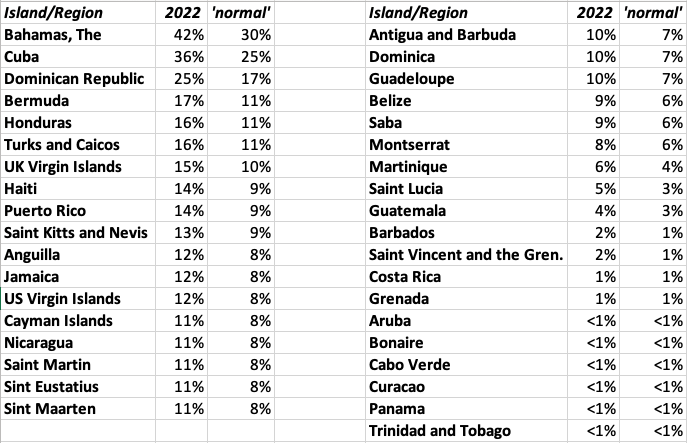 |
| Probability of a major hurricane traveling within 50 miles |
One last note regarding a late start of the season... I read on The Eye of the Storm blog: “If we make it until August 13 with no named storm formations (fairly likely), it’ll be the first time since 1999 that we went from July 4 to August 13 with no named storm formations,” said CSU’s Philip Klotzbach in a Twitter direct message. He added: “Of course, 1999 ended up a hyperactive season, so there’s that!”. That was the year of Floyd and Lenny... Whatever happens happens, the only thing we can do is prepare, prepare, prepare! Stay safe! -Gert
Thursday, July 21, 2022 20:17PM EDT
- Atlantic ramp up soon
-
Good evening all from CLT airport,
Just a quick drop in between the early season eye opening and the impending Atlantic ramp up that is almost certain to manifest itself as we transition from weeks of sudden calm with copious amounts of Saharan dust to a more active pattern starting around the 7-10 day mark into the first few weeks of August. This is not based on my concrete definity but a prognosis based upon experience and the potential atmospheric components coming together as they rotate around the earth. It's their time to be in the Atlantic as they have had the eastern Pacific all to their own the last few weeks.
The SAL, aka Saharan Dust Layer is quite prolific and stretches thousands of miles and in between the rains we received today in the northern islands, extremely welcomed ones by the way, and the next tropical wave that has exited the African coast is a large swath of it. This swath will result in very hazy, hot and dry days for the next almost week. This wave looks impressive upon splashdown but has little chance of development. However, it will sacrifice itself and help pave the way for future waves by moistening the atmosphere ahead of the followers. The wave that exits to the north will have a slightly better chance at initial development but will eventually fall prey to the dust mantis as well.
Look for the first few weeks of August to show tropical life in the Caribbean, maybe the GOMEX and the eastern Atlantic MDR (Main Development Region). If you haven't prepared yet, you still have time but time waits for no man or storm so take advantage of this lull in the action and finalize your preparations.If you have ever been through a Marilyn. Ivan, Irma, Maria and others, you already should know better. Teach and lead the others who do not know or maybe don't want to know. Their lives might depend on it. Not a scare but a truth.
Stay safe and prepared!
Dave
Thursday, June 30, 2022 20:23PM EDT
- IF
-
Good evening all,
IF is a 2 letter word used throughout history but, especially now that the world is in such upheaval and flux both politically and culturally. This word also is applicable to our overall climate and more importantly to us in the Caribbean, particularly hurricane season where the climate and weather is magnified.
IF: Ex 94L n/k/a (Now Known As) PTC2, (Potential Tropical Cyclone 2), was not traveling at a tropical speed of sound of 18-23 mph for much of the last 10 days while staying just a hundred or so more miles away from the South American coastline to the north, we could be watching a Category 3-4 June into July monster of a hurricane approaching the Nicaraguan/Costa Rican Caribbean coastlines. Conditions for this time of year were in rare form for this once in ages potential early season catastrophe. Mother Nature pulled the "IF" clause and said move along PTC2, nothing to see here. So far, it has however given rare doses of heavy rains and gusty winds to the ABC islands which are pretty arid otherwise along with Trinidad/Tobago, northern Venezuela only 7 miles from Trinidad, and northern Columbia.
Further along, PTC2 has pulled away, slowed its forward westward beeline, and is expected to finally morph into Bonnie by tonight into tomorrow. Reaching possibly Cat 1 status by the time it reaches a narrow crossing of land in Central America dumping copious amounts of rain on Nicaragua and Costa Rica. Even while making a swift entry and exit, flooding, mudslides and coastal damage with injuries and fatalities are sadly probable. After traversing this narrow strip and avoiding mountainous terrain, it is expected to enter the eastern Pacific still as Bonnie and eventually make hurricane status on that side. If so, it will be only the second time an Atlantic named storm has retained its name crossing into the Pacific since, I believe 1950 according to historical records.
IF: The wave behind PTC2 hadn't been so close behind, another potential name could have been anointed. Too much interaction with 2's outflow which tailwise is quite a long appendage plus attending wind shear and an influx of Saharan Dust, also dry, have stifled its ambitions at this time. Still, you never know and it still retains chances as it moves WNW. Still, it will give some of the islands some much needed rain as drought conditions exist in several of the Leeward Islands especially the mid to northern ones into Puerto Rico. Still, something to watch.
IF: 95L, not upgraded to this point and might not be, had had another day or 2 over the juicy waters of the western Gulf of Mexico, a serious tropical storm probably would have developed. However, hanging too close to land in the first place with an ingestion of dry air and light wind shear have all contributed to a drought easing, albeit holiday drenching weekend ahead for Galveston, Houston and points NNE into Louisiana with Lake Charles filling up its "Lake". Some beach erosion will occur and minor wind damage as well but the biggest threat here will be too much at one time rains causing flooding in an area prone, even while in drought.
So, activity galore and a wakeup call early in the season. It's only the end of June folks. 5 more months ahead so get your preparations done asap. This part of my post is not an IF. It's a WHEN and WHERE.
Stay safe and prepare!
Dave
Monday, June 27, 2022 18:46PM EDT
- Too active, too early
-
Good afternoon,
Normally this time of year we pay little attention to hurricane alley off to the east of the Windward and Leeward Islands stretching all the way to the Cabo Verde islands close to the African coast. May and June are usually reserved historically for the homegrown variety in the GOMEX, off the east coast and in the SW Caribbean. This year, is an anomaly and a very rare one at that. We do however have a homegrown possibility in addition to these rare potentials off to the east. Wow, it's only June!
PTC2, potential tropical cyclone 2, has been found to contain TS force winds of 40 mph on it's northern side which has necessitated the issuance of tropical storm warnings for Trinidad and Tobago plus Grenada and it's dependencies. The PTC designation now allows the issuance of watches and warnings before a storm is named giving more time for residents to prepare and be aware. A closed surface circulation was not found however and it remains PTC2 but is expected to become TS Bonnie overnight into tomorrow. 3-7 inches of torrential rain is expected from the NE coast of Venezuela all the way up to St. Lucia with lesser amounts flung haphazardly farther north. Barbados will feel the initial impacts and they are expected to receive close to the same spread. However, moving at a relatively speedy 18mph whatever it's designation, flooding rains, gusty winds, rough seas, beach erosion and rip currents with the heavy rain and flooding the biggest threat.
The Bermuda high is expected to force a mostly westward track for this system giving the fairly arid ABC islands of Aruba, Bonaire and Curacao a rare deluge of rain and ts force winds. Flooding here is a real concern even with no mountains to speak of. Further on scraping Colombia, it is expected to reach Cat 1 status before lumbering into Nicaragua as a diminishing storm where flooding will be quite devastating to this very mountainous, steep terrained country. We have sadly seen this before. I do not rule out reaching Cat 2 status though as wind shear is relatively weak and the waters are high octane in that region.
There is an off chance it curves up into the Gulf of Mexico and if it does then that will be another evil kind of animal with nowhere to escape except over land. For now we do not know as way too early to tell. If it does crash into Nicaragua and survive the mountains and fairly short traversing of the country, then it retains a chance at reformation in the East Pacific. For now, we watch, wait and prepare.
Behind former 94L, now PTC2, is another system being assisted by the trailblazing that PTC2 is providing. This one is expected to move on a bit of a more WNW track headed for Guadeloupe, Dominica and points further WNW eventually maybe winding up around the VI's, Puerto Rico, the Turks and Caicos, Bahamas. and maybe even the east coast. Once again too early to tell intensity when it arrives at these locations as cooler water, higher wind shear and more Saharan Dust awaits but it doesn't matter. Get yourselves ready! Hope for the best and prepare for the worst. I've said for many many years it only takes one. I should have copyrighted that saying. More on both these systems in the days ahead as they seem to want to hang on for at least a week or so.
In the GOMEX aka the Gulf of Mexico, the tail end of a front is lingering off the Louisiana coast and the longer it lingers over those juicy waters the more potential for it to react negatively to the Texas coastline from the Mexican border northward as it's forecast track is a bit backwards towards the west (for a Gulf system). Regardless, once again, of it's designation of anything but a Cat 2 and above hurricane, the major impacts will be the deluge of rain and subsequent flooding and we all know how that works out, especially around Houston and Galveston. Let's hope if it does become something, it moves quickly. Again, time will tell.
It's the end of June and it's active already. A harbinger of things to come? Probably yes. If conditions are ripe now, what will they be like in August, September and October?
Stay safe and prepared!
Dave
Thursday, June 23, 2022 08:35AM EDT
- CV Early Interest
-
Good day,
Historically we look closer to the mainland, Gulf of Mexico, and the SW Caribbean for early season troublemakers tropical wise however, we now have an AOI or area of interest not yet dubbed 94L, but probably will be soon just off the coast of Africa near the Cabo Verde Islands.
Forecast to trot across the Atlantic's MDR aka Main Development Region at a modest 15mph, it's development, if any, will be slow to occur due to still relatively cool water temperatures and it's proximity to the ITCZ or the Inter Tropical Convergence Zone that straddles the equator about 10 degrees on either side. It is far enough south though to avoid serious entanglement with the storm protection system we call Saharan Dust which is not very thick at the moment anyway. A wave out in front as Isabel pointed out last night will help pave the way ahead, moisturizing the atmosphere helping to create a protective cocoon for this potential early season systems development. Again, this will be a slow process.
Looking ahead by mid next week, if our early season contender manages to escape the ITCZ and take advantage of the earth's spin, we could have a modest tropical system to contend with. It's path, long term projection wise, would take it through the southern Windward Islands, into the central Caribbean and finally ending up Central America visiting Guatemala, Honduras and Belize. Due to it's far south probability, even islands not used to a plethora of tropical activity like Trinidad/Tobago, Grenada, and even the ABC islands will need to pay closer attention than is customary for them especially since rotating around the globe atmospheric conditions at that time, will be in a favorable spot to enhance any development.
The other scenario is if it manages to spin up much quicker how far more northerly would it go? There it would have to contend with cooler water temperatures, hostile wind shear and our saharan dust shield.
Time will tell but this is an early season heads up of the season to come. If a seedling so far east was to form this early in the season, it does not really bode well for the rest of the season. So, with that in mind, and we are in season already, it's time for preparation if you haven't started. Replace outdated supplies you already have from last year. Check your evac plans. Review that checklist and make sure everyone in your household knows what to do. Yes, seems mundane and yes it takes some time out of our hectic lives to do so but it will save a lot in the long run and quite possibly yours or someone else's life.
Stay safe and prepared!
Dave
Sunday, June 5, 2022 11:03AM PDT - Alex
- This morning the tropical depression was finally upgraded to Tropical Storm Alex. Right now winds are 60mph, with a bit more strengthening possible. However, it is not likely to become a hurricane. On the other hand, it is forecasted to pass pretty close by Bermuda tomorrow, with a closest point of approach of the center of only 75 miles in 24 hours. It will pass north of the island. Strongest winds are on the east and northeast side, so will be felt on the island before the center passes. Tropical storm warnings are in effect already. Bermuda can handle this easily, but still, be prepared, weird things can and will happen. -Gert
Friday, June 3, 2022 19:49PM EDT
- Still PTC 1 but Alex eventually
-
Good evening all,
PTC 1 is continuing to drench SW Florida and the western end to mid parts of Cuba while trekking slowly towards the NE at a paltry 7 mph with top winds at 40 mph and virtually all of the convection to the east of the pseudo center. There is an elongated area considered the center but not totally closed off so hence, no TD, TS or name designation. It really doesn't matter as what you see coming on radar into South Florida south of Orlando. The tropical diet for the next say 36 hours south of I-4 includes: gusty winds, flash flooding, Tstorms with associated heavy rains, isolated tornadoes possible of the EF0/EF1 variety, and sporadic power outages. Maybe an EF2 as well. Wind shear is the saving grace for all as it is preventing consolidation and intensification. This will continue after the system crosses Florida, hounds an already saturated Northern Bahamas, and might even roll the dice with Bermuda if it can hold itself together. Thats not to say areas north of I-4 will not get in on some of the action but it will be limited unless there is a more drastic change in course.
92L is going poof and will pass quietly as wind shear will pick up to inopportune levels thereby sounding the death knell of this wannabe WSW of Bermuda. Maybe later in the season both of these systems would have had major impacts but fortunately that is not the case. However, they may be a harbinger of things to come. Soon to be Alex is a good reminder of the season ahead and that reminder should be heeded.
Off to the east of the Caribbean, waters are warming and temps are rising. The omnipresent Saharan Dust Layer will continue to be the annual early season protector but even then, a system can slip though if low enough or a generous envelope of moisture surrounds and cocoons it from the dust. Tropical waves have started and with a wetter environment over the Sahel, one is bound to slip through eventually.
Stay safe, prepared and have a good weekend. SF, turn around, don't drown.
Dave
Wednesday, June 1, 2022 22:06PM EDT
- Alex in the making?
-
Good evening all,
Well, as if on cue, an early season storm possibility has arisen on June 1st, the official start of the Atlantic hurricane season. The lack of tropical activity in May has been a damper on most people's radar regarding tropical activity and its possible effects hence a serious lack of preparation with a side of complacency. Not good.
The remnants of Cat 2 Pacific Hurricane Agatha has crossed the Mexican coast into the Western Caribbean leaving a trail of early season death and destruction across Mexico's Oaxaca State. Merging with a low pressure system, these remnants, soon to be renamed Alex at some point, are at this moment designated 91L. Hurricane hunters are expected to investigate tomorrow afternoon for a preliminary look at this seemingly benign early season system. However, interests in Cuba, Florida and the western Bahamas should be wary. Why you ask?
While wind shear is expected to remain high at 20-30 knots which usually would destroy any storm systems' evil intents to intensify, the nice warm waters of the GOMEX is 82+ degrees. Yummy for a fledgling storm. Heat, the engine that fuels these storms, and coupled with a generously moist atmosphere around 75-85% humidity, the potential for the first named storm of the Atlantic hurricane season is almost a given regardless of the wind shear. Not to say the possibility exists it won't occur but yes, very probable. Now, where will it go?
Preliminary models show a moderate NE trek with the Yucatan Peninsula of Mexico getting doused first as just a major rain event. Then slow to moderate strengthening over those juicy waters of the GOMEX while dumping heavy rains across the western end of Cuba and maybe the Caymans are next. Upon arrival on Florida's SW coast, it's a toss up at this moment in time. Will it be a TD or a low grade TS? Or will Alex exceed expectations and maybe a hurricane? Too early to tell at this point but if 91L develops and the wind shear is not as strong as forecast, could we see a Tampa Bay hurricane landfall? Hmmmm Hopefully the TB shield will hold. Needless to say South Florida is in for a drought buster and wildfire put out event.
After visiting Disney and Universal, the Bahamas need to be on guard as we will have a lot of uncertainty at that point. Be prepared and stay safe.
Dave
Saturday, May 28, 2022 00:20AM PDT - Ready for the new season
- A ritual I do every year around this time..., making the website ready for the new year. Above the list with new names. The names are re-used every six years, however, especially notable (destructive) storms are retired and replaced with new ones. New for this year are Martin and Owen, that replaced the 2016 storms Matthew and Otto, who hit Haiti and Panama and Costa Rica, resp.
As Dave and I mentioned below before, it is expected to be another above-normal season..., a new normal? The main reason are the high chances of La Nina conditions this summer. El Nino normally surpresses hurricane activity due to higher wind shear. Jeff Masters on the Eye on the Storm blog gives a 'nice' summary of all the different forecasts out there, if you need further convincing.
Just a few more days before the official start. For a change no early storm this year. But they will come. Best to get ready now. Check out your storm shutters, batteries, power packs for keeping your phones charge, emergency food/water, you guys know the drill! Stay safe everybody this yeer! Greetings from Hawai'i, where I am getting ready to embark on a research cruise! -Gert
Sunday, May 1, 2022 18:06PM EDT
- It's almost that official time
-
Good afternoon and Happy May Day also known as International Labor Day in many countries where the rank and file are still the bedrock of most economies but often forgotten/neglected.
31 days until the official start of the 2022 Atlantic Hurricane season and preliminary forecast's reflect another above average tropical system season with a major hurricane impact's chances somewhere in the Caribbean, GOM and the CONUS likely. Where, obviously way too early to gauge, but nowhere and no one should be unprepared if you live in these areas. Recent history, ongoing cleanup and restoration in some places and recalled memories are all the reminders needed of what can take place during and after the deed is done. Less than 5 years after catastrophic Cat 5 twins Irma and Maria roared through the NE Caribbean and Puerto Rico 12 days apart, life in many areas affected has still not reached a sense of normalcy, especially in Puerto Rico. Recovery of lives and economics, of course, was thoroughly disrupted even further by the advent of Covid 19 and ongoing subsequent variants to this day. Now, we have other risks in other areas of the world and in Washington whose effects are compounding further progress.
Yes folks, it's almost that official time, June 1st. We in the Caribbean look at that date like we Americans look at April 15th (Tax D-Day). However, the same can be said for both dates. We can prepare for both. We know the seasons are coming as time always marches on. So with that said it's time to start preparing for the upcoming tropical season. Check your old supplies and replace them with fresh ones. Have an evacuation plan. Have an emergency plan as help will not be coming during the storm and unlikely right after if you are hurt. Water, canned food, a manual can opener, medication supplies are among necessities that should be on hand. Don't forget your pets as they are family too. Preparation may not save all of your property but if it saves your life and your loved ones, then property lost doesn't mean much. That can be replaced eventually.
Will May kick off the start of the season with a few weak disturbances, maybe a couple early names, even a minor hurricane? Stay tuned and we will find out the answer shortly. The Saharan Dust Layer (SAL), usually our annual early season protector in the Caribbean, is in place and quite robust off the coast of Africa which means it will meander it's way westward soon. But then, so will those tropical waves. For the time being though we look for homegrown storms close to the east coast and the SW Atlantic.
Stay safe and prepared!
Dave
Sunday, April 10, 2022 15:06PM PDT - Above average season?
- On April 7 Colorado State University came out with a new forecast for the upcoming hurricane season. Researchers Klotzbach and Bell expect an above average season with 19 named storms, 9 hurricanes of which 4 major ones. Last 30 year average is 14.4, 7.2 and 3.2, resp.
The main reason for the above average season is the unlikelihood that there will be El Nino conditions this summer, which would suppress hurricane formation. Also, current SST patterns seem typical for more busy years... Analogue years (years with similar atmospheric/ocean conditions as this year) are 2021 (last year!), 2012, 2008, 2001, 2000 and 1996. Of these, 2008 stands out for me, with Ike, Omar and Paloma... If it is like last year, not too bad!
The chance for at least one major storm to travel through the Caribbean (a large area) is 60% (42% is normal). See below a table with the probably of a major hurricane moving within 50 miles of a specific Caribbean island/country compared to the long term average (1880-2020) (taken from: https://tropical.colostate.edu/TC_impact.html)..
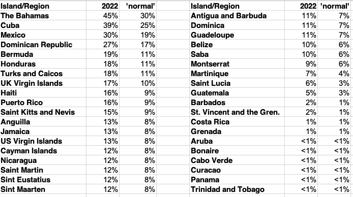 |
| Probability of a major hurricane traveling within 50 miles |
With all this being said, the April forecast is traditionally not that accurate. So we should not take the above too serious. The next one in June will have more skill. Regardless, it is good to think about the upcoming season so that we can slowly mentally prepare for it... Stay safe! -Gert
Maintained & moderated by: Gert van Dijken (gert@gobeach.com).
Weather discussions also by Dave McDermott, St.Thomas, USVI.