|
|
- - - 2022 Hurricane Season - - -
|
- A hell of a Rein
|
- By Jurgen Starck <weather at turtle48.de>
- Date: Sun, 23 Apr 2023 14:47:53 -0400
|
|
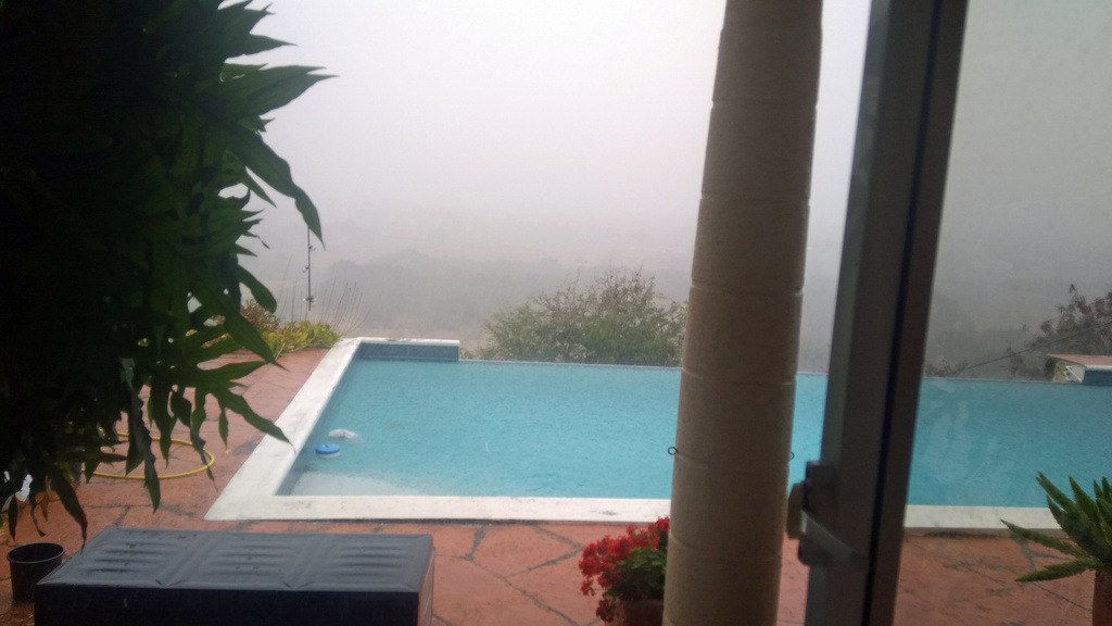
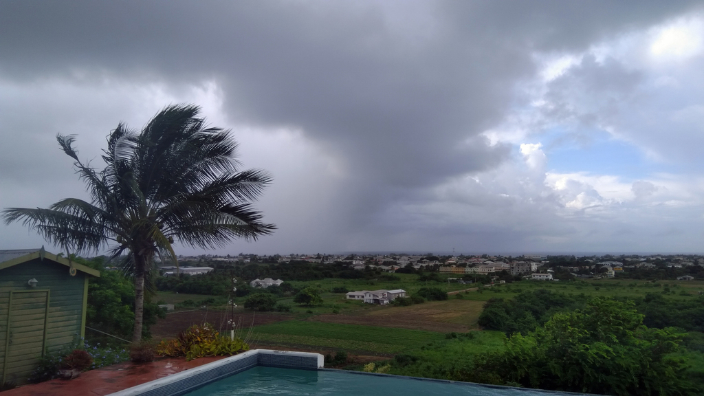
Good afternoon everyone,
at about 13:45 AST a hell of rain broke loose and smashed at
least the southern part of Barbados with a horrendous amount of
water. Good for the Garden but no good for people on the road. The
strong rain lasted for about half an hour, now as I type, its just
drizzling. This weather is expected to last into Wednesday. A long
before announced large Trough is pulling through the area, mostly
affecting the southern Windward Islands. Flash-Flood Warning is in
effect since this morning.
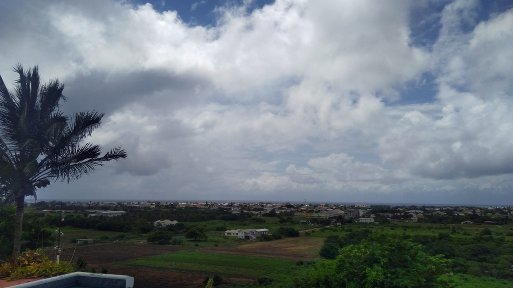
The rain on the ground.

As Zoom is seeing it. The colours are
indicating the precipitation.

Barbados Weather Service radar image.
That was a little taste of what is to came later.
Best regards. Be prepared and stay safe
and dry!
Jurgen, from Barbados, South, near airport (BGI)
|
|
- Sargassum seaweed
|
- By Jurgen Starck <weather at turtle48.de>
- Date: Thu, 13 Apr 2023 10:21:11 -0400
|
|
Good morning everyone,
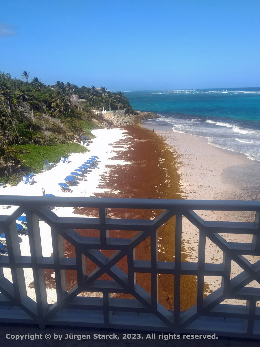
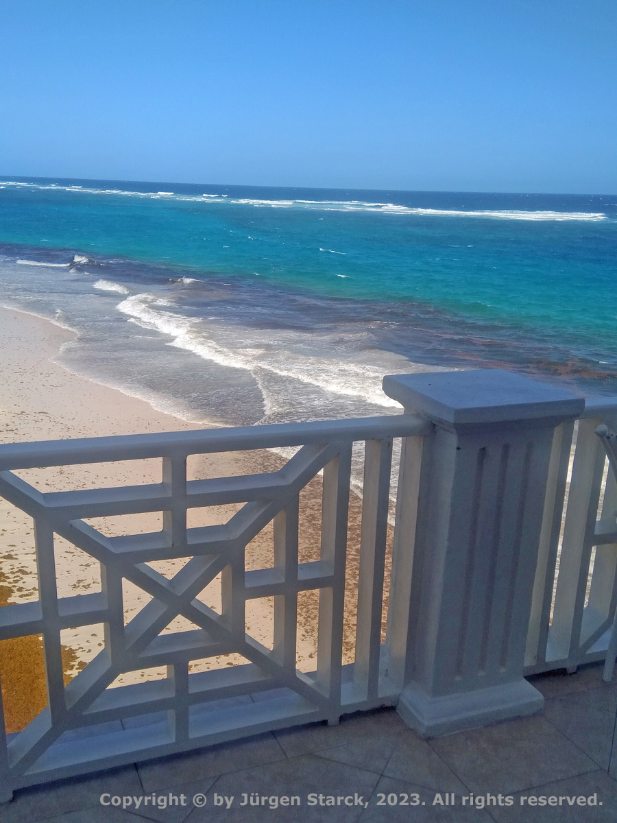
This is an article about the seaweed in Barbados on our local TV
website. The first two pictures could be seen in a local TV report
last night. This plage is massive this year, like never seen
before. It is forecast to go on that bad until into July or so. It
is real problem to remove it from the beaches. Very bad for
tourism!
https://www.cbc.bb/cbctest/?s=Sargassum
Have a great day.
--
Best regards. Be prepared and stay safe and dry!
Jurgen, from Barbados, South, near airport (BGI)
|
|
- Drought forecast for the region
|
- By Jurgen Starck <weather at turtle48.de>
- Date: Wed, 29 Mar 2023 09:56:53 -0400
|
|
Good morning everyone,
the following article appeared in today's edition of a local
newspaper.
<a
href=""https://www.nationnews.com/2023/03/28/drought-forecast-region/"
target="_blank">Drought forecast for the region</a>
Have a nice day.
--
Best regards. Be prepared and stay safe and dry!
Jurgen, from Barbados, South, near airport (BGI)
|
|
- Sargassum Seaweed, hands off!
|
- By Jurgen Starck <weather at turtle48.de>
- Date: Thu, 23 Mar 2023 15:10:29 -0400
|
|
Good day everyone,
I have read a number of reports from other special hurricane
correspondents about the Sargassum Seaweed (Sargassum). My thanks
to Jane Higgins (St.Thomas) and "Hogan" (Grenada).
Since this yearly re-occurring "pest" seems to be the new
seasonal normal since about 2015, I also wanted to make a
contribution to the subject.
I have seen it for the first time in Barbados in 2015, see link
below "Best Caribbean Beach".
On February 12th, this year, I took two more photos of the said
"Beat Caribbean Beach":
Left: The seaweed on the beach. Right: There is more coming.
Not so much the "Best Caribbean Beach" any more.
Particularly not for the "High Season"!
However, how unbelievably it may sound, I saw a few guests
walking through it and took a plunge into the Atlantic.
The Problem with that type of seaweed are,
1) when it dries up it starts to rot and develops a very
unpleasant odour! Nothing that you want have in your nose while
sunbathing near it.
2) In some years it came in such masses onto our shores, so that
it brought the fishing industry pretty much down fore some weeks.
Some farmers came up with the idea to make fertilizer for plants
out of it. Even worse, some chefs made dishes with it!
BOTH BAD IDEAS!
Soon after that, our government brought these types of use to a
stop, after a lab has found that this seaweed contains quit a bit
of heavy metals, which are bad for human health!
Related links:
Location of photos:
google-maps
Best Caribbean Beach:
https://www.nationnews.com/2015/02/04/crane-voted-best-caribbean-beach/
Sargassum Bay (Fishery Problems):
https://www.nationnews.com/2015/05/11/sargassum-bay/
Wikipedia about Sargassum:
https://en.wikipedia.org/wiki/Sargassum
Well, that's it for today. Be safe everyone.
--
Best regards. Be prepared and stay safe and dry!
Jurgen, from Barbados, South, near airport (BGI)
|
|
- Flash-Flood Warning
|
- By Jurgen Starck <weather at turtle48.de>
- Date: Fri, 28 Oct 2022 09:07:09 -0400
|
|
Good morning everyone,
As of 7:00 am Barbados is under Flash-Flood Warning. So far it
will expire at 6:00 pm today, if not updated.
Barbados weather radar

--
Best regards. Be prepared and stay safe and dry!
Jurgen, from Barbados, South, near airport (BGI)
|
|
- Heavy Rain !
|
- By Jurgen Starck <weather at turtle48.de>
- Date: Mon, 10 Oct 2022 09:56:43 -0400
|
|
Good morning to all,
since about an hour Barbados is getting
pounded with heavy rain! A Flash-Flood Warning has been issued
by the Barbados Meteorological Service. The fields below us are
partially covered with water because the ground was already
saturated.
Here it comes, about an hour ago, looking
South-West.

20221010_083940_Rain_coming_DSC_3911.jpg
Looking South.

20221010_083950_Rain_coming_DSC_3912.jpg
Looking East.

20221010_083950_Rain_coming_DSC_3912.jpg
Here it is.

20221010_085357_There_it_is_DSC_3931.jpg
OK, I done writing, the rain done raining. That was a lot of
rain!
Have a good day, everyone.
--
Best regards. Be prepared and stay safe and dry!
Jurgen, from Barbados, South, near airport (BGI)
|
|
- To St. Lucia
|
- By Jurgen Starck <weather at turtle48.de>
- Date: Mon, 10 Oct 2022 07:36:18 -0400
|
|
Hi, Nada Sonia in St. Lucia,
I would say, this "loop swirly feature" are the remnants of
former Tropical Depression #12, which is drifting North-West and
now getting ripped apart by wind-sheer or something like that.
Have a nice day.
--
Best regards. Be prepared and stay safe and dry!
Jurgen, from Barbados, South, near airport (BGI)
|
|
- Nicaragua - TAKE COVER!
|
- By Jurgen Starck <weather at turtle48.de>
- Date: Sat, 8 Oct 2022 18:11:12 -0400
|
|
Good evening everyone,
I wished the people in Nicaragua would be able read this, even
though I have my doubts they could.
The poor people over there are actually getting another brunt of
nature, as if they wouldn't have had enough during the past few
years. I really feel sorry for them and how they could possibly
prepare for more to come in the future when climate change is
making everything much worse for the entire globe.

Current status: TS JULIA affecting Nicaragua already with its
wind and rain field.
I actually don't know what else to say.
--
Best regards. Be prepared and stay safe and dry!
Jurgen, from Barbados, South, near airport (BGI)
|
|
- INVEST 91L - For Ian and all of T&T
|
- By Jurgen Starck <weather at turtle48.de>
- Date: Thu, 6 Oct 2022 09:10:51 -0400
|
|
Hello Trinidad,
NOTE: The following
information does NOT claim to be exact, there it is entirely
without any warranty whatsoever. Don't rely on this
information if you may have to make serious decisions for your
survival!
Barbados weather radar at 08:10 AST.

20221006_081000_INVEST_91L_BWS_Radar.jpg
How much longer may it last?
In order to answer that question I played a little bit around
with zoom.earth, see partial screenshot below.
Below the words "TRINIDAD & TOBAGO" in the partial screenshot
below you see a label saying "147 km". This label partially covers
a slanted white line that peeps out to the left (in the middle of
Trinidad) and to the right (at the south-eastern edge of INVEST
91L). Those 147 km represent the length of that slanted line.
Below that you can see another label saying "30 km/h". That is the
wind speed. And the wind is coming from ESE.
Let's assume the wind speed is near the speed of the system's
forward speed. For easier calculation let's round up 147 -> 150
km.
Hence, we get 150 km / 30 km/h = 5h. It may take 5 hours,
starting at 8:30, for the system to have left Trinidad. That would
be 13:30 (1:30pm) today.
As I said above, this might not be
exact! Don't rely on it in critical situations! It is more
like an educated guess!
Take these 5 hours as the MINIMUM period of time until it
might over.
Partial screenshot of Trinidad and Tobago

20221006_083000_INVEST_91L_TT_Details.jpg
Good luck to everyone!
--
Best regards. Be prepared and stay safe and dry!
Jurgen, from Barbados, South, near airport (BGI)
|
|
- Thank you Ian from T&T !
|
- By Jurgen Starck <weather at turtle48.de>
- Date: Thu, 6 Oct 2022 08:11:34 -0400
|
|
Dear Ian,
I thank you very much Ian for your kind words! I appreciate it
very much. It's good to know that one's work may have helped
someone else in some way, no matter how little or how much.
Take care, Ian and all your fellow countrymen and women and who
else may be over there.
--
Best regards. Be prepared and stay safe and dry!
Jurgen, from Barbados, South, near airport (BGI)
|
|
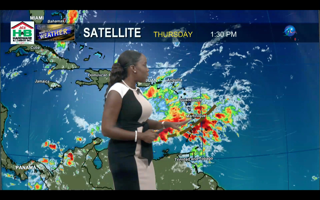
- INVEST 91L - let the pictures talk
|
- By Jurgen Starck <weather at turtle48.de>
- Date: Wed, 5 Oct 2022 12:48:38 -0400
|
|
Good afternoon to all,
Below the images are the filenames, the begin with to numbers,
indicating date and time in AST (UTC-4).
NHC Tropical Weather Outlook

20221005_080000_INVEST_91L_NHC_Tropical_Weather_Outlook.jpg
Radar imagery from Barbados

20221005_120500_INVEST_91L_BMS_Radar.jpg
Air Force reconnaissance mission

20221005_121544_INVEST_91L_USAF_Hurricane_Hunter.jpg
Visible Satellite

20221005_121500_INVEST_91L_Satellite_visible.jpg
See yuh.
--
Best regards. Be prepared and stay safe and dry!
Jurgen, from Barbados, South, near airport (BGI)
|
|
- INVEST 91L - final statement by BMS
|
- By Jurgen Starck <weather at turtle48.de>
- Date: Wed, 5 Oct 2022 09:45:23 -0400
|
|
Good morning everyone,
https://www.nationnews.com/2022/10/05/tropical-wave-passes/
Nothing to add to this.
Have a great day.
--
Best regards. Be prepared and stay safe and dry!
Jurgen, from Barbados, South, near airport (BGI)
|
|
- INVEST 91L - first winds coming
|
- By Jurgen Starck <weather at turtle48.de>
- Date: Tue, 4 Oct 2022 23:09:32 -0400
|
|
From Barbados again,
a little earlier than 23:00 hours the first smooth and fresh
(chilling) winds were coming in. The latest CAP-Warning just came
in and is not stating any significant changes. Neither in wind
speeds nor in downfall or forward speed compared to the previous
one which I had posted. One storm-force wind gust has been
detected near the airport.
Have a good night folks.
--
Best regards. Be prepared and stay safe and dry!
Jurgen, from Barbados, South, near airport (BGI)
|
|
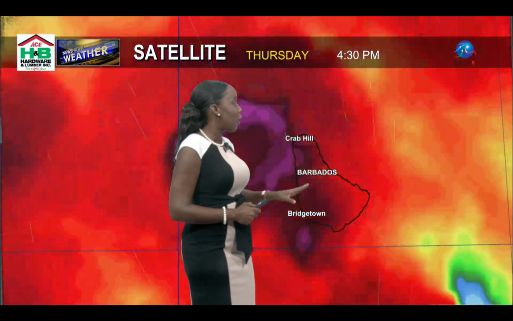
- INVEST 91L - closing in
|
- By Jurgen Starck <weather at turtle48.de>
- Date: Tue, 4 Oct 2022 20:27:54 -0400
|
|
Good evening all,
I think what is coming tonight is not much to worry about, unless
one is living in a flood prone area with already well saturated
grounds. Downfall is forecast to 1-3" with 4" in a few locations
of Barbados. Otherwise, just some hard hitting rain on the roof
and some gusty storm-strong gusts of wind. Please, note the pink
frame below.
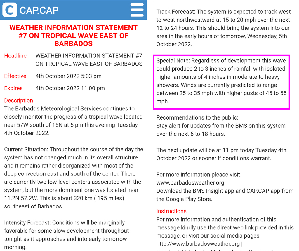
Barbados Weather Service CAP-Warning.
Weather Forecast on local TV tonight.

Depending on how precise that Graphic is, The two centres of
Invest 91L (yes TWO centres!) might even pass a click south of
Barbados, I am not taking a bet on that, though. In this case
however, not good for Grenada and the Grenadines and T&T.
It is obviously not going to hit the Leeward Islands! So, keep
calm Isabel in St. Croix and Jane in St. Thomas. 😉
Everyone take care and watch it anyway!
Good night neighbours!
--
Best regards. Be prepared and stay safe and dry!
Jurgen, from Barbados, South, near airport (BGI)
|
|
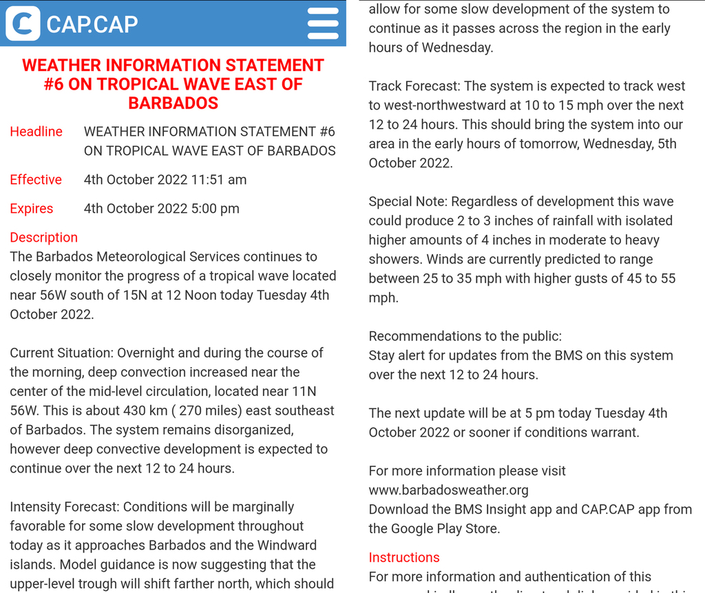
- INVEST 91L Warning
|
- By Jurgen Starck <weather at turtle48.de>
- Date: Tue, 4 Oct 2022 12:12:34 -0400
|
--
Best regards. Be prepared and stay safe and dry!
Jurgen, from Barbados, South, near airport (BGI)
|
|
- Low level trough NOT over yet!
|
- By Jurgen Starck <weather at turtle48.de>
- Date: Thu, 29 Sep 2022 21:13:00 -0400
|
|
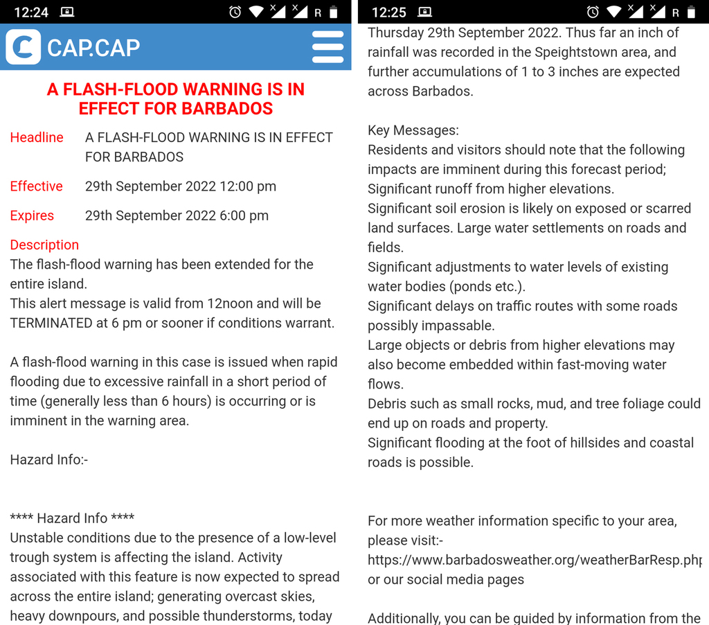
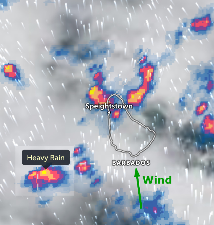
Good evening to all,
here comes a brief summarization of tonight's Barbados' weather
report/forecast. I think the screenshots are speaking for
themselves. Please, pay particular attention to the last
screenshot!
Winds Across Barbados currently: Gentle southerly to
south-easterly breeze from 10 to 30 km/h (6 to 19 mph) with higher
gust.
Situation around midday today:
Situation in the afternoon (enlarged):
Forecast for tonight: (read the text below
the temperatures!)
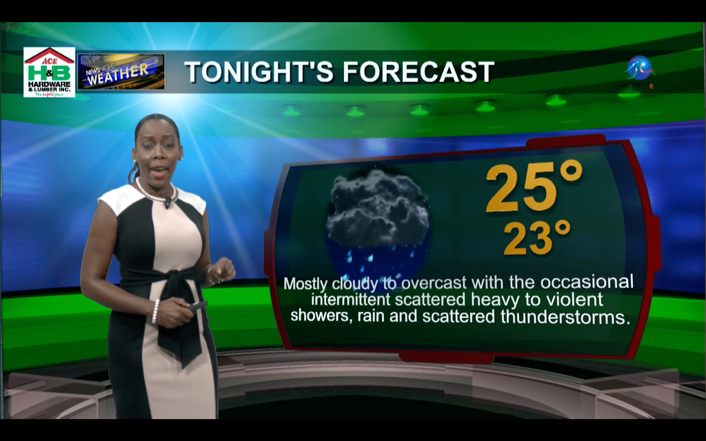
Good night to all.
--
Best regards and stay safe, prepared and dry!
Jurgen from Barbados South, near airport (BGI)
|
|
- Holy Moly!
|
- By Jurgen Starck <weather at turtle48.de>
- Date: Thu, 29 Sep 2022 18:22:48 -0400
|
|
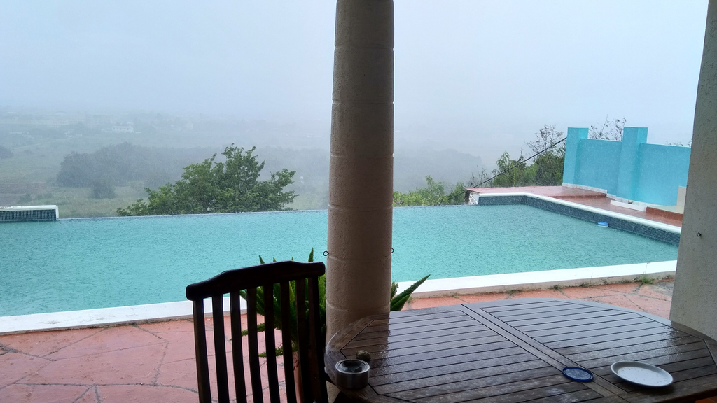
Good afternoon all,
Today was I got caught on the wrong foot. Around noon I saw a
trough coming our way, then I remembered it was mentioned in the
local weather forecast last night.
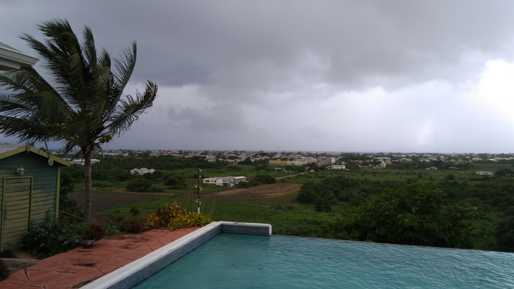
There it comes...
At about the same time, I received a flash-flood warning.
CAP warning.
I have never ever experienced a rain like this other than during
active storms around here! The rain smashed in from the south with
nearly storm-force gusts!
 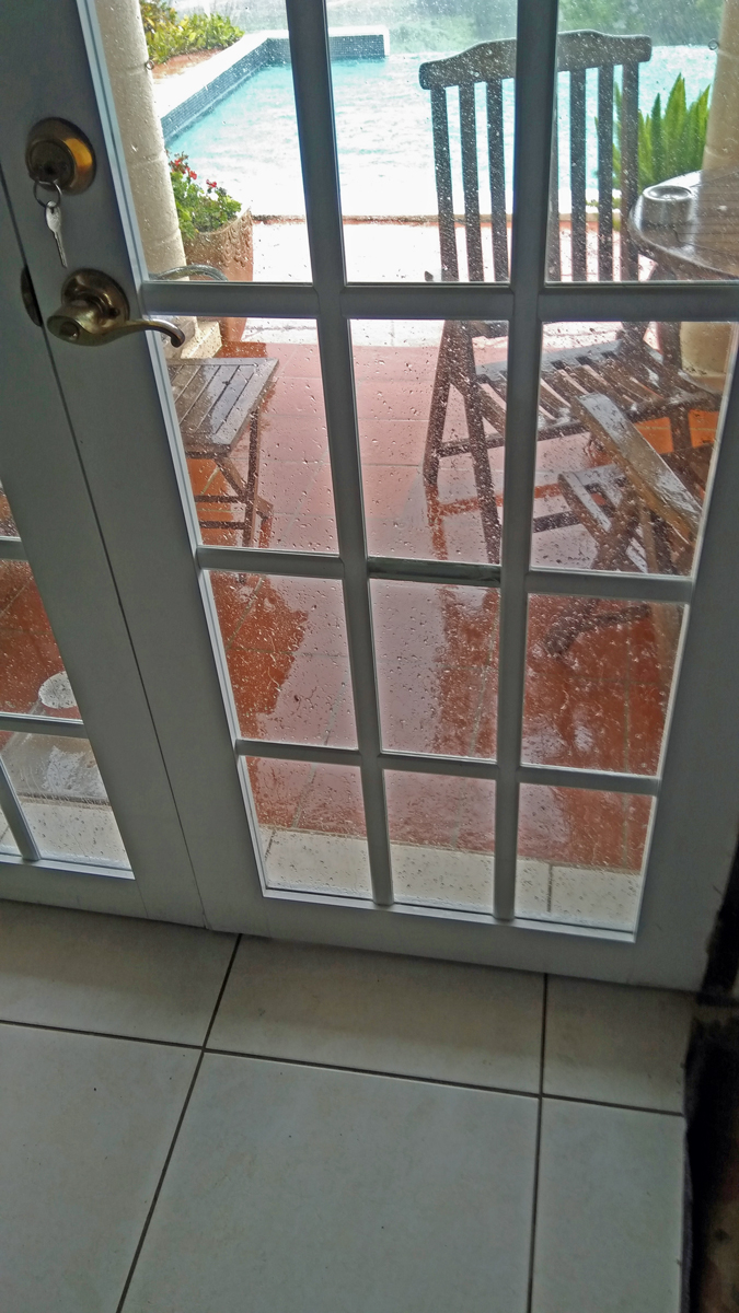
The rain reached up to the door handle of the terrace door!
Made the cat food (left on grey tray) collateral damage. That
door is about 10-11" recessed from overhanging roof.
The rain was coming in really hard on ran into the room below the
door, even though they have these rubber lips at the bottom.
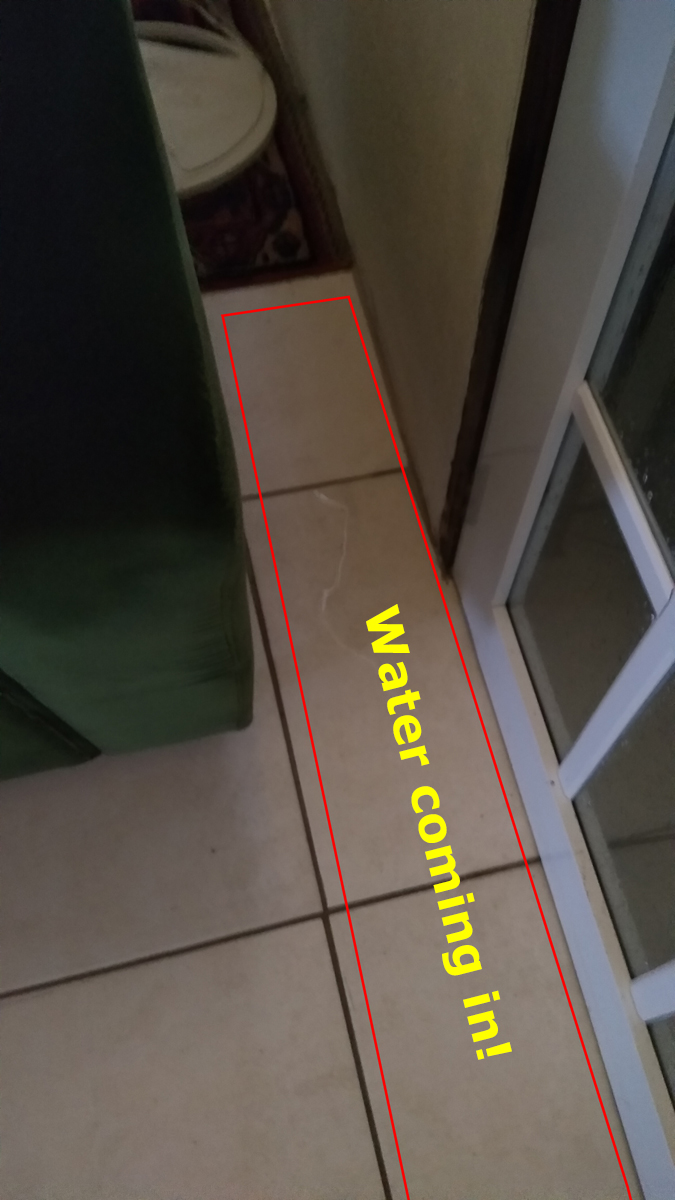
Well, it was not a drama, but an annoyance.
As a consequence, I had to call "general mop" for duty. The most
important tool today.
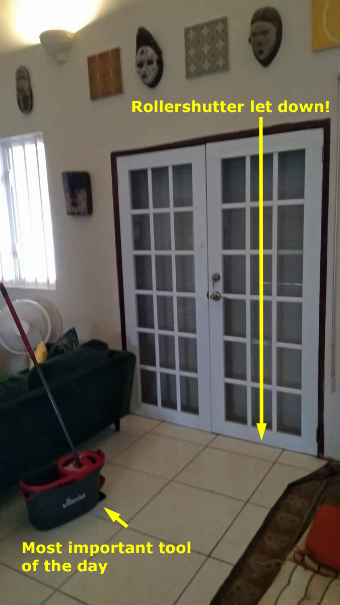
After the shutter was down I could relief "general mop" of his
duties.
Then some heavy gusts were coming in and the rain even smashed to
the top of the windows or higher, but I couldn't see that from
inside.
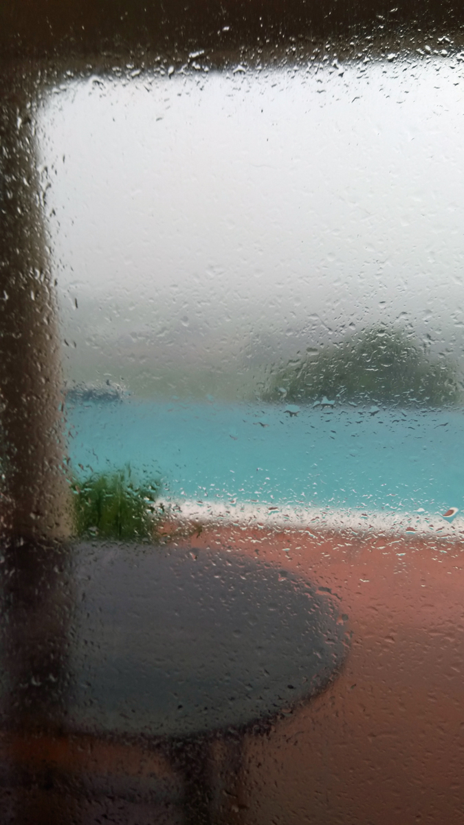
Rain hammering against the windows.
At least two flights had to in holding patterns, due to very bad
visibility.
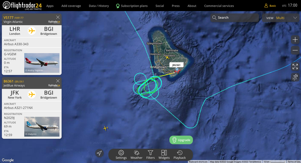
Air traffic impacted as well.
I have never seen any rain like this one today, only with TS
THOMAS (2010) and H1 ELSA last year. Today there was no storm
here, just a "trough" with near storm-force gusts!
As I am closing this story for today the CAP warning, see above,
has been extended until 6am tomorrow.
May you all have a good night and stay dry.
--
Best regards and stay safe and prepared!
Jurgen, from Barbados South, near airport
(BGI)
|
|
- Barbados getting long lasting rains
|
- By Jurgen Starck <weather at turtle48.de>
- Date: Mon, 26 Sep 2022 11:09:14 -0400
|
|
Good morning everyone,
Barbados is under a Flash-Flood Warning as well as a Severe
Thunderstorm Watch, due to a shear-line rolling across the island.
Rain is currently continuos and lightning and thunder are
sporadic, and some strikes are really strong.
Good luck to all who are affected by IAN! Take care everyone.
--
Best regards and stay safe and COVID-19 free! Keep your distance!
Jurgen
Barbados South, near airport (BGI)


|
|
- I agree
|
- By Peter Allen <stilettocruises at yahoo.com>
- Date: Sun, 25 Sep 2022 00:26:56 +0000 (UTC)
|
The bad I always starts down low,with the exception of Ivan who was low and
got lower for Tobago and really was a monster for Grenada and beyond.Them eyes
don't forget them.
|
|
- INVEST 98L passing South of Barbados
|
- By Jurgen Starck <weather at turtle48.de>
- Date: Wed, 21 Sep 2022 12:10:15 -0400
|
|
Good morning everyone,
since this morning I can perfectly watch
INVEST 98L passing South of Barbados. Bringing frequent short
showers and some wind. Earlier this morning the weather station at
the airport (BGI) showed 51 km/h sustained winds and gusts up to
85 km/h. The winds are less strong at this time of writing.
This morning at 08:00 AST, looking straight South.
Taken at 10:40 AST. Heading for the Southern Windward Islands.
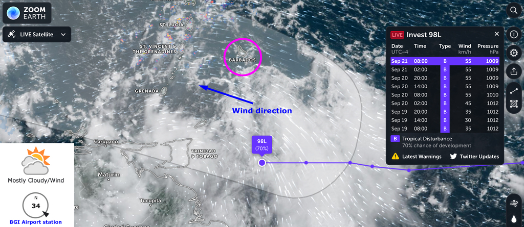
Situation at 11:00 AST.
On the real, animated map it looks like as if there would be a
centre of circulation (COC) be in the making to the South of
Trinidad. However, the question of course is, how precise this
animation is compared to reality.
Good luck everyone, everywhere.
--
Best regards and stay safe and COVID-19 free! Keep your distance!
Jurgen
Barbados South, near airport (BGI)
|
|
- Tkank you Dave !
|
- By Jurgen Starck <weather at turtle48.de>
- Date: Mon, 19 Sep 2022 16:32:02 -0400
|
|
The fact that you are sending kind words like you did, means a
lot to me!
Very much appreciated.
Kind regards.
--
Best regards and stay safe and COVID-19 free! Keep your distance!
Jurgen
Barbados South, near airport (BGI)
|
|
- I forgot to send the link for my last post, sorry!
|
- By Jurgen Starck <weather at turtle48.de>
- Date: Sun, 18 Sep 2022 23:47:28 -0400
|
|
Here is the link:
https://zoom.earth/storms/fiona-2022/#overlays=wind
--
Best regards and stay safe and COVID-19 free! Keep your distance!
Jurgen
Barbados South, near airport (BGI)
|
|
- This is a reply for Kate in Vieques
|
- By Jurgen Starck <weather at turtle48.de>
- Date: Sun, 18 Sep 2022 23:38:08 -0400
|
|
Dear Kate,
I saw your post on the Vieques page of stormcarib.com. I am a
fellow correspondent on the Barbados page. May be this graphic may
help you. At least I hope so.
Fiona just in the Mona passage, as Dave mentioned in his
detailed as always comment today. He is always a little ahead of
NHC. Well worth to be commanded!!! Thanks Dave!
I wish you and all the other northern Caribbean islands up to
Bermuda the best of luck!
Sincerely!
--
Best regards and stay safe and COVID-19 free! Keep your distance!
Jurgen
Barbados South, near airport (BGI)
|
|
- Holy sh** (rain)
|
- By Jurgen Starck <weather at turtle48.de>
- Date: Sun, 18 Sep 2022 00:15:04 -0400
|
|
Just now a hell of a rain was coming down here and I had to rush
inside in order not to get my laptop or myself getting totally
soaked. The rain is all of a sudden hammering onto my roof. Any
phone calls or such would be impossible to listen to.
Conclusion: Once you think its over don't you ever think it is!
And Barbados is right now not even in the mid of it at all! So,
may you be very careful what is coming towards your area. As we
all should know, the bad part of such a storm is always the
South-East quadrant. So to speak, the "fat" end with lots of rain.
Thunder and lightning are adding to it.
Take care everyone!
--
Best regards and stay safe and COVID-19 free! Keep your distance!
Jurgen
Barbados South, near airport (BGI)
|
|
- Overcast cloud cover getting ripped apart by blue holes
|
- By Jurgen Starck <weather at turtle48.de>
- Date: Sat, 17 Sep 2022 14:32:52 -0400
|
|
Good afternoon all,
I am not aware if Barbados had any
considerable rain after midnight. But we haven't had any since
the morning even though the sky was completely overcast here in
the South. About 1/2 hour ago "blue holes" started peeping
through the clouds and it's getting friendlier by the minute.
The coconut tree in the picture indicates the breeze is coming
in from South-East. Things are getting back to normal.
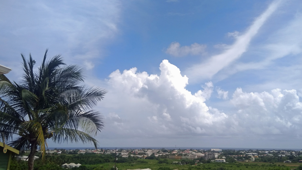
Looking good.
Here one, just for the fun of it and it's rare occurrences:
Empty Eastern Caribbean air space, a very rare sight. Spiced up
with the partial flight track of the latest Hurricane Hunter
mission.
Here a link to what happened in Guadeloupe for those who are
interested. Severe flooding over there, cars washed away and sadly
1 casualty and 1 missing person. Some reports say 2 deaths. When
you watch the damage keep in mind that this was "just a storm",
not even a hurricane. Wind was obviously not the major culprit but
the copious amounts of water Fiona delivered.
https://rci.fm/guadeloupe/infos/Risques-naturels/En-images-Fiona-dechaine-les-eaux-sur-la-Guadeloupe
Good luck to all who are having Fiona still ahead of themselves!
--
Best regards and stay safe and COVID-19 free! Keep your distance!
Jurgen
Barbados South, near airport (BGI)
|
|
- Breeze and showers from South-South-West
|
- By Jurgen Starck <weather at turtle48.de>
- Date: Fri, 16 Sep 2022 14:54:53 -0400
|
|
Good afternoon all,
currently the winds and showers which are coming in to Barbados
are not coming from TS FIONA, instead they are going into
Fiona. Fiona feeder bands seem to suck in everything they can
get a hold of. The wind is coming in from the South-South-West.
Inbound and outbound flights are going which ever direction they
choose either West or East. Funny.
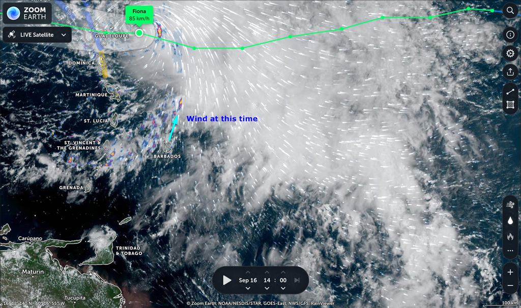
Note the huge cloud field of Fiona and the centre of rotation
at the front end!
It looks like, that Barbados would be in form some rain as well
later.
Good luck to all.
--
Best regards and stay safe and COVID-19 free! Keep your distance!
Jurgen
Barbados South, near airport (BGI)
|
|
- Hurricane Hunter near TS FIONA
|
- By Jurgen Starck <weather at turtle48.de>
- Date: Thu, 15 Sep 2022 15:10:10 -0400
|
|
Good afternoon everyone,
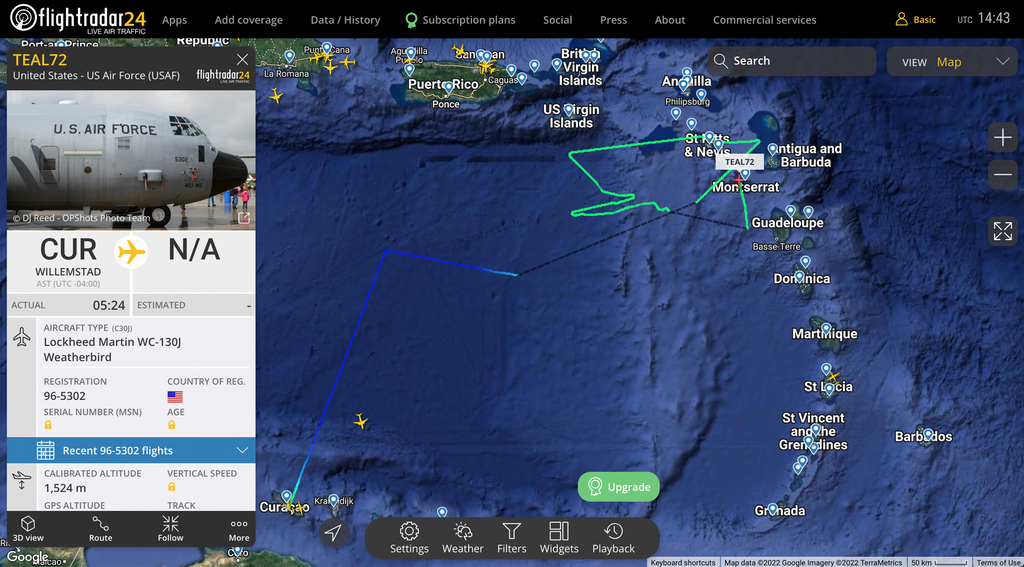
just a short note: Coming from Cuarçao, a US Air Force Hurricane
Hunter is currently near TS FIONA, as Dave and the NHC have
mentioned.
US Air Force Hurricane Hunter
--
Best regards and stay safe and COVID-19 free! Keep your distance!
Jurgen
Barbados South, near airport (BGI)
|
|
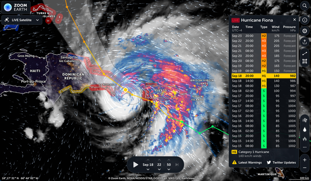
- TS FIONA - DIRECT HIT to St Croix !!!
|
- By Jurgen Starck <weather at turtle48.de>
- Date: Wed, 14 Sep 2022 23:41:46 -0400
|
|
Good night again,
That was a very quick development!
TS FIONA
At current the CPA Tool of this website predicts a direct hit
to St Croix!!!
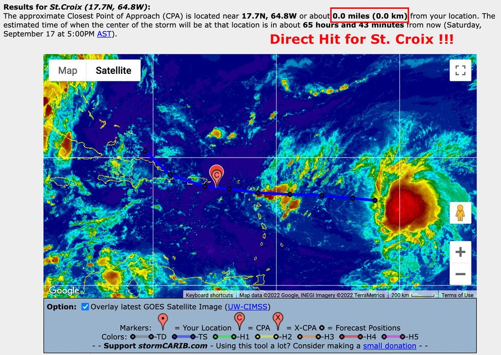
Tropical-storm-force winds extend outward up to 140 miles (220 km) east of the centre.
Considering the size of the wind field it may probably become a
direct hit for almost all the islands in the North-Eastern
Caribbean.
Get ready in St Croix et all!
Good night and good luck to everyone in the path!
--
Best regards and stay safe and COVID-19 free! Keep your distance!
Jurgen
Barbados South, near airport (BGI)
|
|
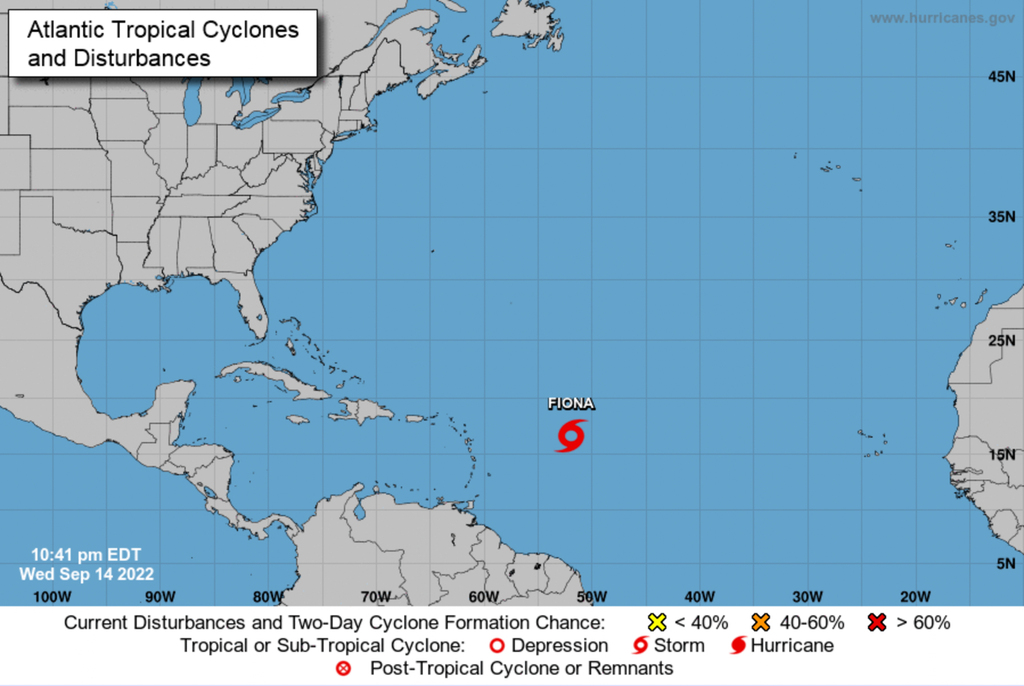
- TD SEVEN today - may be TS FIONA tomorrow!
|
- By Jurgen Starck <weather at turtle48.de>
- Date: Wed, 14 Sep 2022 21:24:07 -0400
|
|
Good evening to all,
a message to all Leeward Islanders up to Puerto Rico and may be
even Hispaniola. Everyone who has posted today before me was
talking about TD SEVEN. Hence, I am writing this_
You may not only want to look forward to much needed rain but
also for TS FIONA, according to the graphic below.
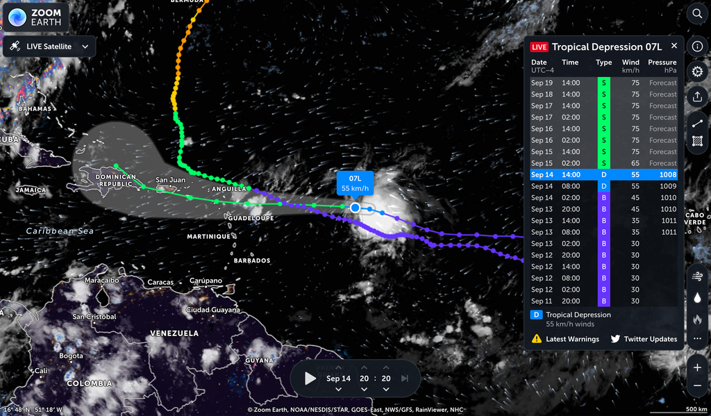
Take a look at the coloured vertical bar to the right of the
graphic where it is getting green and look at the dates.
According to this table TD SEVEN is supposed to become a TS
(Fiona) by 2am tonight or at least 2pm tomorrow.
I think it is advisable to take all lightweight, easily flying
"projectiles" out of your open spaces or secure them as long as
there is still time left for it. Better safe than sorry. If my
interpretation may be wrong, I would be happy to apologize.
However, I did not create the graphic.
Preparation it is. Good night to all.
--
Best regards and stay safe and COVID-19 free! Keep your distance!
Jurgen
Barbados South, near airport (BGI)
|
|
- Never seen this from BWS
|
- By Jurgen Starck <weather at turtle48.de>
- Date: Mon, 12 Sep 2022 16:49:30 -0400
|
|
Good afternoon to all,
I don't remember to have ever seen an
official statement like this from the Barbados Weather Service
(BWS) ever before. But since we, the stormcarib.com community
are close neighbours, I thought I should share this with you,
because it could potentially affect all of us.
The BWS issued a "Heat Information
Statement" today. I never heard that term before. So, here it
is:
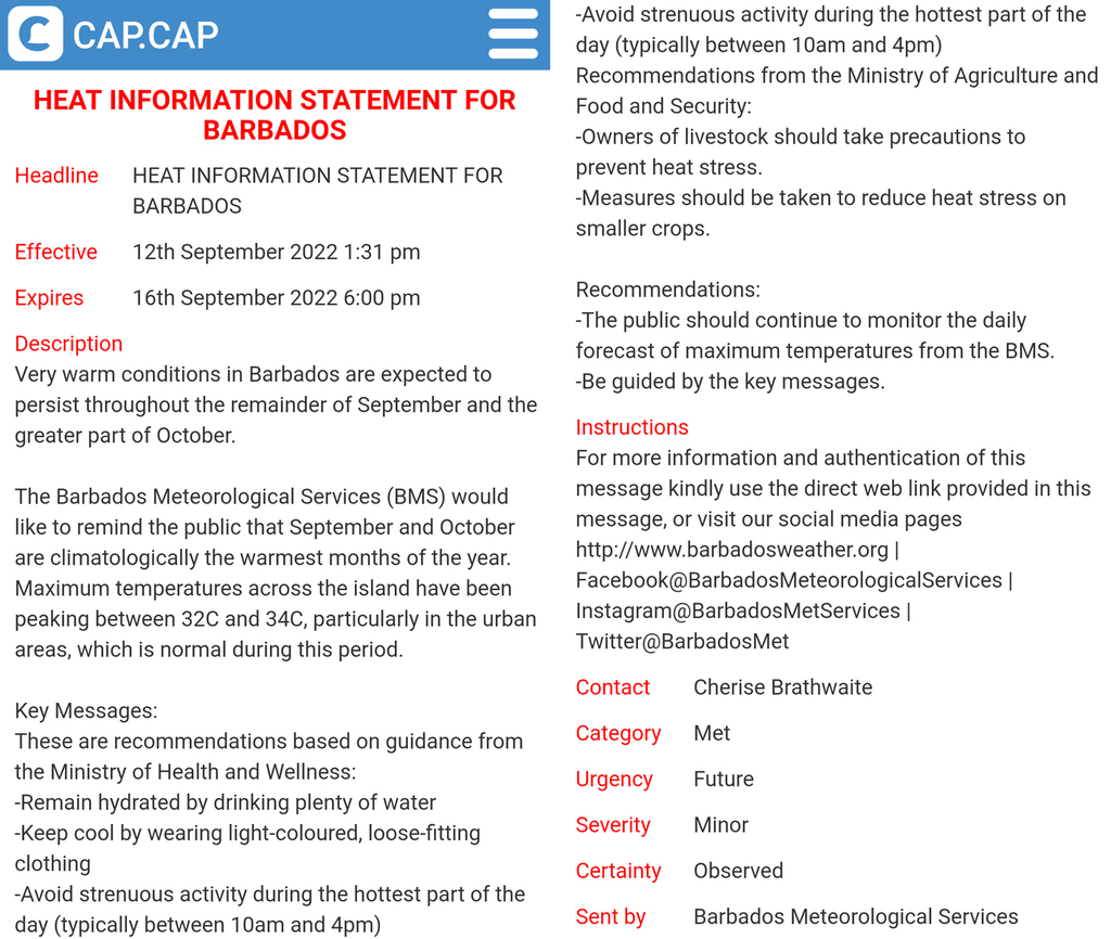
A good night to all.
--
Best regards and stay safe and COVID-19 free! Keep your distance!
Jurgen
Barbados South, near airport (BGI)
|
|
- Flash-Flood Warning
|
- By Jurgen Starck <weather at turtle48.de>
- Date: Sun, 4 Sep 2022 09:49:40 -0400
|
|
Good morning everyone,
the day began with a quite long lasting moderate rain. This led
the BWS to publish a flash-flood warning for Barbados valid until
12:00 (noon), for now.

The winds came in with a southerly component, soaking my entire
terrace, including the cat food bowls.

The cause of this rain was another Tropical Wave in the trail of
TS EARL.

The Tropical Wave South-East of Barbados.

BWS Weather Discussion.

So much for now.
Enjoy your Sunday.
--
Best regards and stay safe and COVID-19 free! Keep your distance!
Jurgen
Barbados South, near airport (BGI)
|
|
- INVEST 91L from space
|
- By Jurgen Starck <weather at turtle48.de>
- Date: Fri, 2 Sep 2022 21:02:04 -0400
|
|
God evening to all,
below you will find a video of today's action in the skies. The
dynamic in the clouds is almost breathtaking. I have focussed this
screen recording on the Leeward Islands, because that is where the
action is going to happen tonight and tomorrow. The recording is a
time lapse of the past 12 hours.
Enjoy it or be amazed what ever you prefer.
Good night to all and be safe.
--
Best regards and stay safe and COVID-19 free! Keep your distance!
Jurgen
Barbados South, near airport (BGI)
Attachment:
20220902_200000_INVEST_91L_animation_by_ZOOM_EARTH.mp4
Description: video/mp4
|
|
- INVEST 91L - A real piece of Interest
|
- By Jurgen Starck <weather at turtle48.de>
- Date: Wed, 31 Aug 2022 00:53:51 -0400
|
|
Good evening to all,
this INVEST 91L must literally be a real
piece of INTEREST to the NOAA Hurricane Hunters. They are
obviously running a relay against 91L handing over the baton
from one aircraft (type) to another. Every day another one but
also the same Hurricane Hunter which I have mentioned in my last
post has been coming back to Barbados, refuelling and heading
out for the "not yet beast" 91L.
As me being an amateur, I am observing and
more guessing rather than knowing, to be honest. Since, this
season and its long term forecasts has bluffed everyone as to be
an above average season until now, add climate change to the
bill, which has not panned out as yet to be, it seems to be of great interest to NOAA to find
out more. May be they are sending all these different hurricane
hunters down here in order to explore 91L in very much more
detail to find out what is going on or not going on for a
reason. Meaning, to learn more about new weather/climate
patterns.
Climate change has overrun everyone and continues to do so. I
have evidence of it even here in Barbados. Even before just
the term "climate change" hit the world wide news stage!
So, what is to come next? This question has
to be answered by hesitating politicians, the weather-pros,
including the NHC and "Klotzbach et all". All of them need to
rethink!
Back to reality as of today.
As Isabel wrote on Aug 29 on the St Croix page so
rightly, some "wobbles" during the move of a system can make a
big difference for the people in its path. Now, look here for
the wobbles just happening...
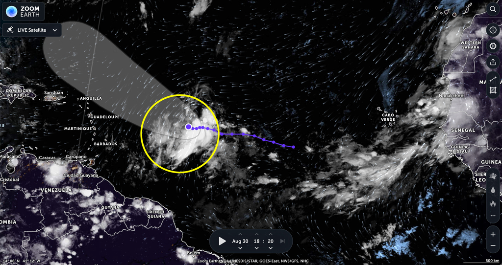
INVEST 91L wobbling down and up (look close)... what's next?
Keep watching!
Also, the cone is just predicting the tolerance of the path of
the centre of a system, but NOT its ALL OVER SIZE (other than
storm force winds)! Look at it. Just compare the size of the cone
and the size of the clouds (yellow marking). This beast can even
bring flash floods and more to the entire Eastern Caribbean. WATCH
OUT PEOPLE!
The latest Hurricane Hunter just came back
from a mission. Minutes ago.
NOAA43 just returned back to Barbados.
All of you "Leewarders" keep watching 91L!
Have a good night everyone.
--
Best regards and stay safe and COVID-19
free! Keep your distance!
Jurgen
Barbados South, near airport (BGI)
|
|
- General information to all
|
- By Jurgen Starck <weather at turtle48.de>
- Date: Sun, 28 Aug 2022 20:12:07 -0400
|
|
The Barbados Weather Service
(BWS) has evolved to become a very good regional source for
weather information as well. In the past few years they have just
not only improved their hardware and software for collecting
weather related data independently (independent from NHC),
they now have their own direct satellite access for that matter,
and as a result they have improved their accuracy of forecasts
tremendously. It is just amazing compared to what it was years
ago!
I can also recommend their radar and satellite pages for near
real time views. However, the radar only reaches out 400 km from
Barbados where the range ends at about Guadeloupe. The delay to
real time is up to about 10 minutes.
No worries, I am not getting paid for these recommendations. I am
just a convinced user myself and I use their information nearly on a
daily basis when necessary.
Another very good website is zoom.earth.
This one is absolutely terrific. However, it needs a little time
to figure out all of its features (use the menu to the right to
figure out). But, I can promise, it's worth a try. It is based on
NHC data but much more detailed and more frequent rather than what
is available on the currently official NHC website. It also
provides animations of wind directions and wind speeds all any
point all over the screen.
I am hoping that you will enjoy at least a try of all of the
above said.
Good night everyone.
--
Best regards and stay safe and COVID-19
free! Keep your distance!
Jurgen
Barbados South, near airport (BGI)
|
|
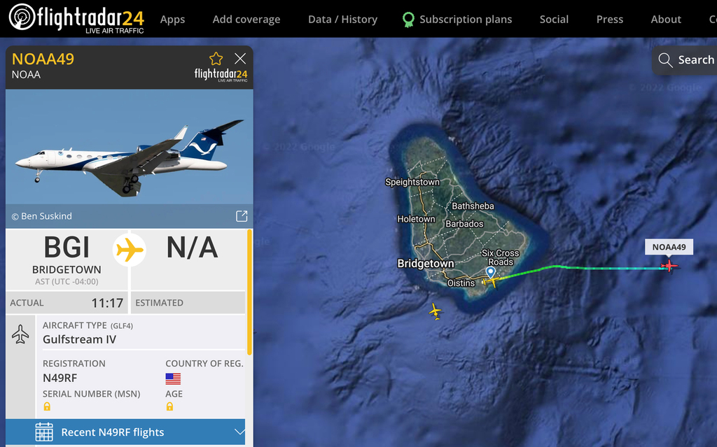
- Hurricane Hunter back to Barbados
|
- By Jurgen Starck <weather at turtle48.de>
- Date: Sun, 28 Aug 2022 19:04:29 -0400
|
|
Good evening to everyone,
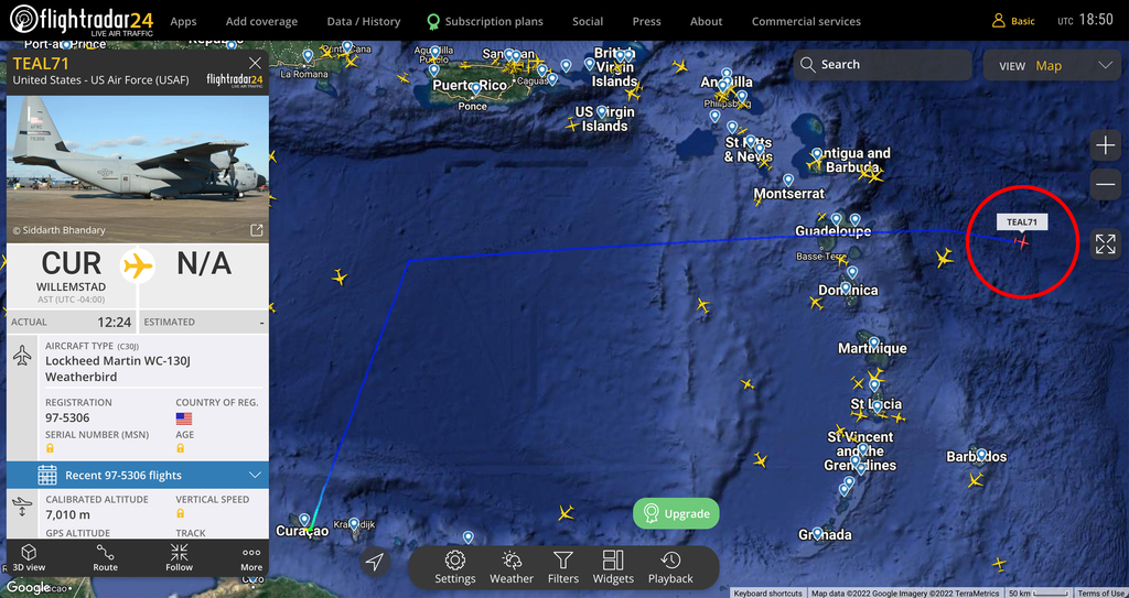
The Hurricane Hunter mentioned before has landed in Barbados. I
am hoping that the next NHC advisory will mention some of the
insights of that mission. Particularly the Leeward Islands should
watch this closely.
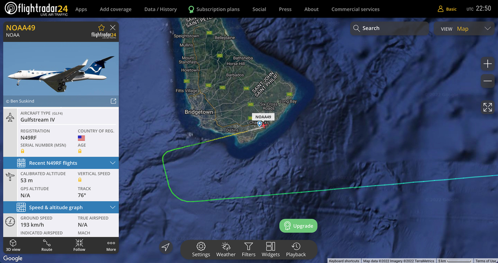
Hurricane Hunter has landed.
God night to all.
--
Best regards and stay safe and COVID-19 free! Keep your distance!
Jurgen
Barbados South, near airport (BGI)
|
|
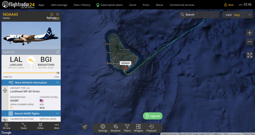
- Hurricane Hunter on it's way
|
- By Jurgen Starck <weather at turtle48.de>
- Date: Sun, 28 Aug 2022 11:37:47 -0400
|
|
Good day everyone,
a NOAA Hurricane Hunter transformed Gulfstream IV has just left
Barbados heading straight East. I am guessing, it is going to
examine INVEST 91L.
Hurricane Hunter underway.
Enjoy the rest of the day.
--
Best regards and stay safe and COVID-19 free! Keep your distance!
Jurgen
Barbados South, near airport (BGI)
|
|
- Thanks to Jane
|
- By Jurgen Starck <weather at turtle48.de>
- Date: Fri, 19 Aug 2022 22:54:43 -0400
|
|
Many thanks to Jane from St. Thomas for her explanation to my
latest post. Very much appreciated!
Good night to all.
--
Best regards and stay safe and COVID-19 free! Keep your distance!
Jurgen
Barbados South, near airport (BGI)
|
|
- Dozens of lightning strikes
|
- By Jurgen Starck <weather at turtle48.de>
- Date: Fri, 19 Aug 2022 21:09:50 -0400
|
|
Good evening all,
This is more a question rather than a report.
I just have observed dozens of lightning strikes south of
Barbados. Some of them were even spreading horizontally all over
the horizon I was able to see. I have never seen anything like
this in my entire life. There was only lightning to see but no
thunder to hear. May be this happened too far away to hear it. If
anyone would have an explanation for this, I would appreciate to
let me know.
May be Gert or Dave may have an idea?
--
Best regards and stay safe and COVID-19 free! Keep your distance!
Jurgen
Barbados South, near airport (BGI)
|
|
- Update to my previous post
|
- By Jurgen Starck <weather at turtle48.de>
- Date: Sat, 13 Aug 2022 18:34:02 -0400
|
|
The "show" is not over yet. Just minutes ago the BWS has extended
the Flash-Flood Warning until tomorrow morning 6:00 am.
If you fellow islanders, no matter where, want to know what to
expect, then click the link below. I recommend to do that on a
computer or a tablet, not on a smartphone.
https://zoom.earth/#view=15.629,-61.983,7z/date=2022-08-13,17:10,-4/map=live/overlays=wind
Once the page has loaded, click the play button near the bottom
of the page and wait until the animation has been fully loaded.
This might give you some sort of insight of what you might can
expect.
Good night for now to everyone.
--
Best regards and stay safe and COVID-19 free! Keep your distance!
Jurgen
Barbados South, near airport (BGI)
|
|
- TW causing Tons of water - Flash-Flood warning
|
- By Jurgen Starck <weather at turtle48.de>
- Date: Sat, 13 Aug 2022 17:26:15 -0400
|
|
Good afternoon all,
today Barbados got literally tons of water by repeated showers
from a Tropical Wave.
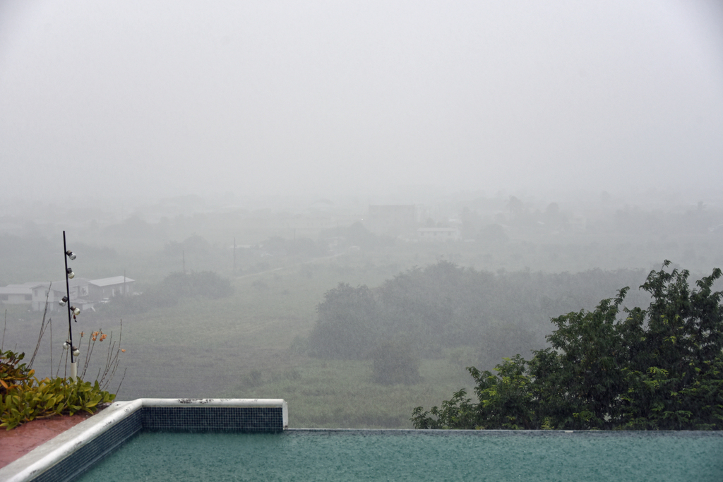
The rainfall intensity was from moderate to heavy as seen in
the picture.
Duration of each shower varied from short, like less than 10
minutes to medium like minutes in the two digits. Accumulated
amounts of rain became serious so that the BWS felt it was
necessary to publish a Flesh-Flood warning across Barbados,
effective as of 14:22 until 18:00 today.
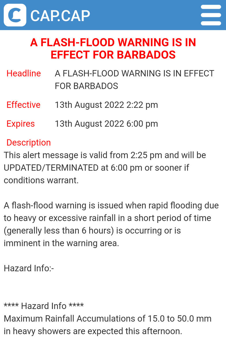
Shortened version of the original warning.
I am hoping the Leeward Islands also have profited from that TW,
water wise. Let me know, please.
That's it for now.
--
Best regards and stay safe and COVID-19 free! Keep your distance!
Jurgen
Barbados South, near airport (BGI)
|
|
- Disturbance 1, aka INVEST 97L
|
- By Jurgen Starck <weather at turtle48.de>
- Date: Wed, 10 Aug 2022 22:32:54 -0400
|
|
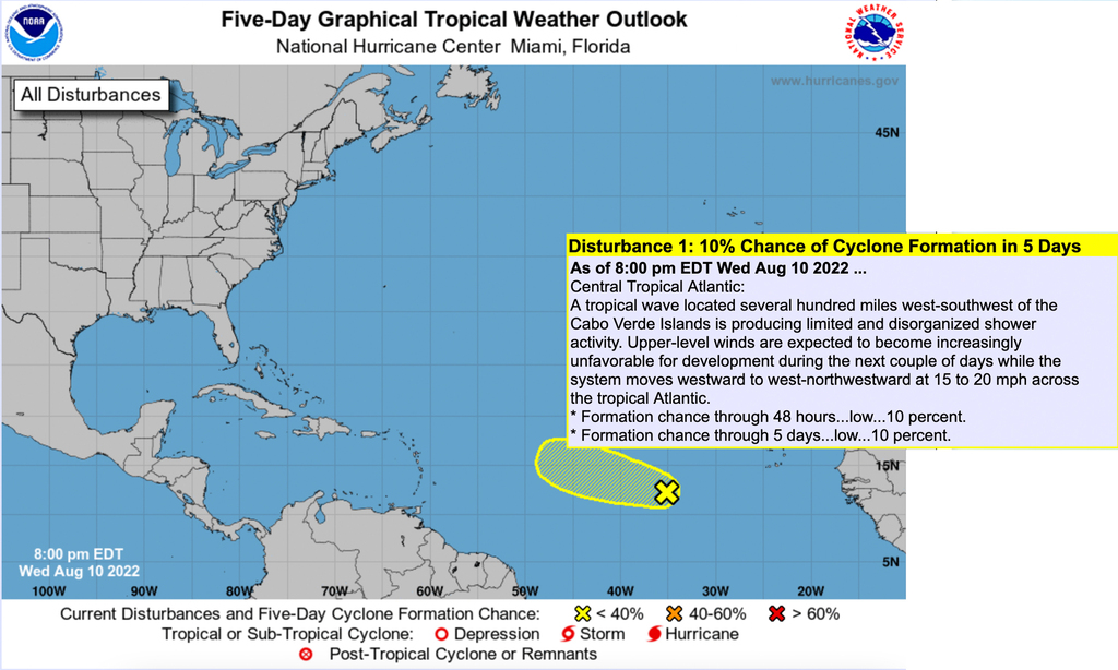
Good evening all,
as of tonight, it looks like that my last post turns out to have
been a false alarm. Even the NHC has reduced it's predictions for
disturbance 1, aka INVEST 97L, down to a 10% chance of development
within a 5-day range. I am thinking that this is good news.
However, it still should be watched. It wouldn't be the first
mistake of the NHC.
Take care.
--
Best regards and stay safe and COVID-19 free! Keep your distance!
Jurgen
Barbados South, near airport (BGI)
|
|
- Rain, Rain, Rain
|
- By Jurgen Starck <weather at turtle48.de>
- Date: Sat, 6 Aug 2022 18:53:14 -0400
|
|
Good evening to all,
today was a day as the title says.
"Rain, Rain, Rain,"
(and to make it a rhyme)
"I aint complain!"
Strong but short shower.
About just a few seconds after the first drops were falling more
than half of the table was soaked, saying it got stronger fast.
Visibility towards the distance was very limited as usual.
As of time I am writing we had half a dozen of these showers
today, starting around midday until now. Duration was varying
between 5-15 minutes. But all strong.
Our garden must be happy as Larry!
But that is not all I wanted to tell.
As of today the NHC has a "big one" on it's radar. Not that I am
waiting for it, but this Tropical Wave seems to be important
enough for the NHC to mention it. When I caught it first, it was
only on the five-day-forecast image, not at the front image.
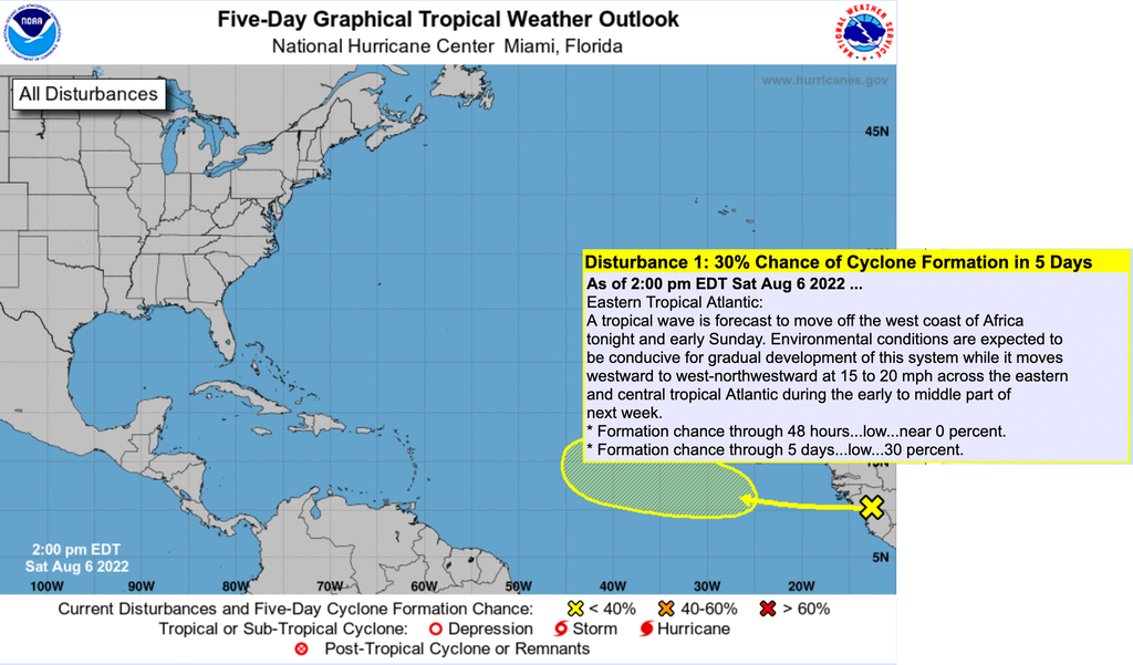
30% in five days.
Hence, I looked elsewhere:
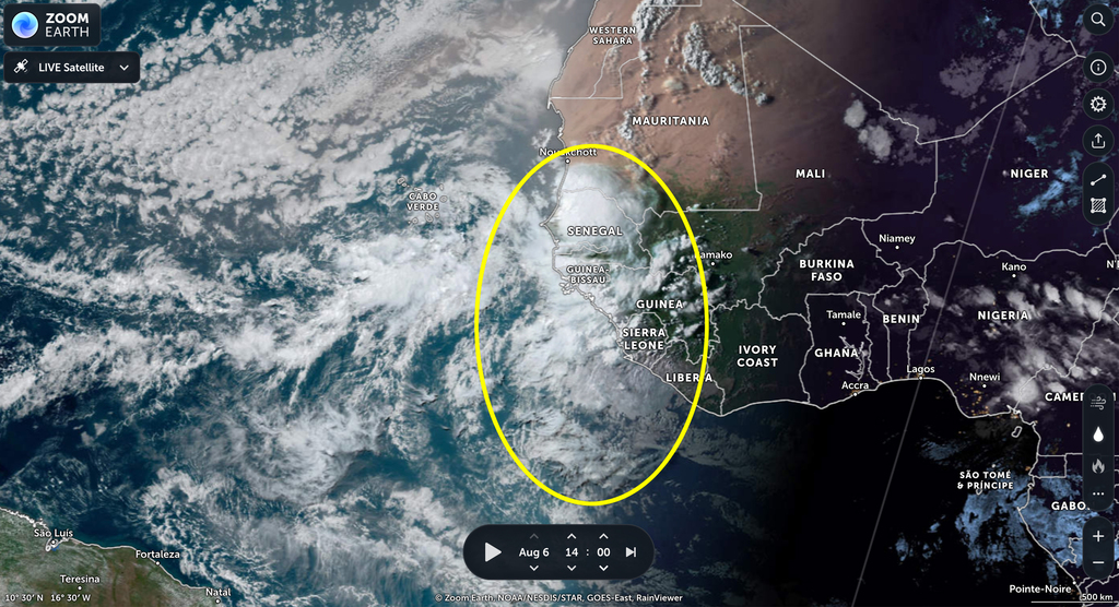
The marking shows the approximate size. Looks kinda a "Biggie" to
me. But that does not necessarily need to mean much. ;-)
That's it for tonight. Keep watching this one.
Good night everyone.
--
Best regards and stay safe and COVID-19 free! Keep your distance!
Jurgen
Barbados South, near airport (BGI)
|
|
- Swirling dust
|
- By Jurgen Starck <weather at turtle48.de>
- Date: Fri, 29 Jul 2022 07:47:17 -0400
|
|
Good morning all,
this post is meant to be an explanation for
Jane Higgins question from St. Thomas.
Click here:
https://zoom.earth/#view=13.1,-39.4,5z/date=2022-07-28,07:00,-4/map=live/overlays=wind
Once that page is loaded click the play
button near the bottom of the page. Wait a seconds until the
animation has completely loaded. Then you will see a slowly
rotating patch of clouds in the centre of the image. I am
guessing the dust is just riding piggy-back on the clouds.
By the way, this webpage is a tremendous
tool for tracking storms, much more detailed than the usual NOAA
pages. It also delivers more detailed forecast data.
Best regards.
--
Best regards and stay safe and COVID-19 free! Keep your distance!
Jurgen
Barbados South, near airport (BGI)
|
|
- Disturbance 1
|
- By Jurgen Starck <weather at turtle48.de>
- Date: Fri, 1 Jul 2022 12:39:24 -0400
|
|
Good day to all,
The most part of Disturbance 1 is passing North of Barbados.
However, that doesn't mean the we are going away empty handed.
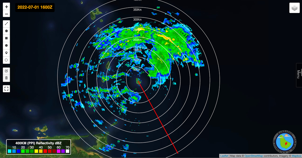
Barbados weather Radar at 12:00 pm local time.
The Barbados Weather Service (BWS) is predicting only little rain
of 15 mm accumulated amount for the day.
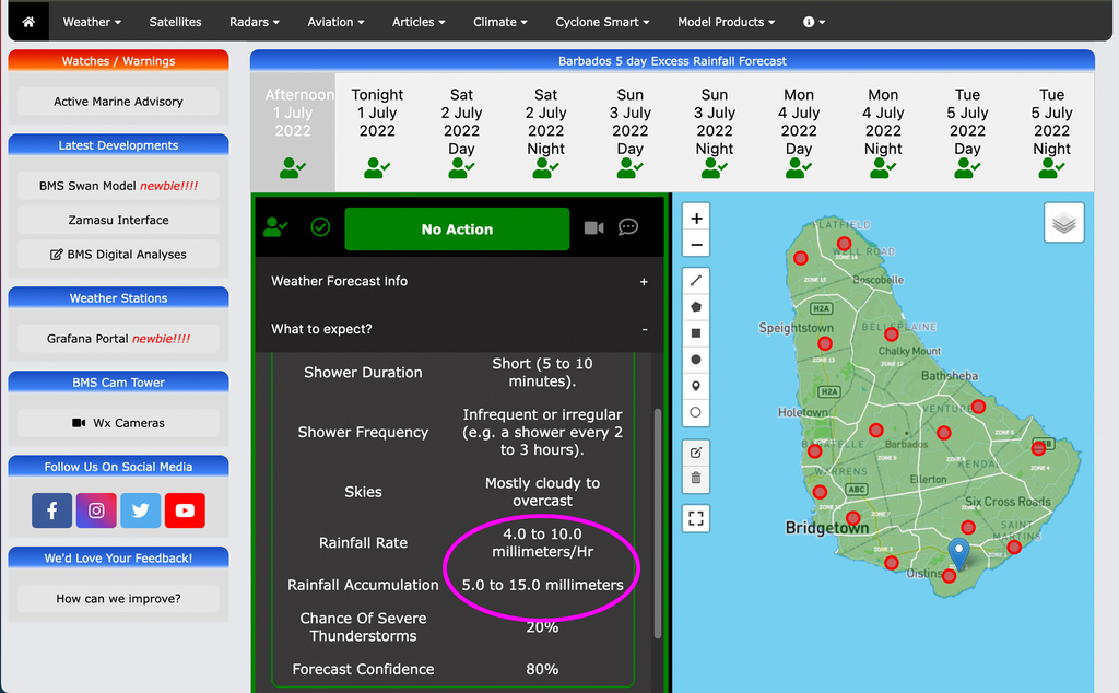
BWS accumulated amount of rain (pink marking).
However, we got a good lashing from the outskirts of Disturbance
1, before it was really here. The attached video is from this
morning at about 8 am. It lasted only some minutes. Since then we
haven't had anything stronger than that. But it was good enough
for the garden.
That's it for now. Take care everyone.
--
Best regards and stay safe and COVID-19 free! Keep your distance!
Jurgen
Barbados South, near airport (BGI)
Attachment:
20220701_080412_Disturbance_1_Barbados.mp4
Description: video/mp4
|
|
- Just for the record, Hurricane Hunter now in St. Croix
|
- By Jurgen Starck <weather at turtle48.de>
- Date: Tue, 28 Jun 2022 17:35:01 -0400
|
|
Good afternoon to all,
I caught it a lil late, but the Hurricane
Hunter "Miss Piggy" (nickname of the aircraft) that we had here,
was out for another mission, but obviously it either had its
transponder turned off or it was flying too low. Not even
flightradar24.com could detect it. It was flying for an unknown
period of time very low at an altitude of 950 ft. above sea
level! Then it went up to cruising level and eventually landed
in St. Croix, USVI. May be Isabel up there could take her "End
of day photo" at the airport?
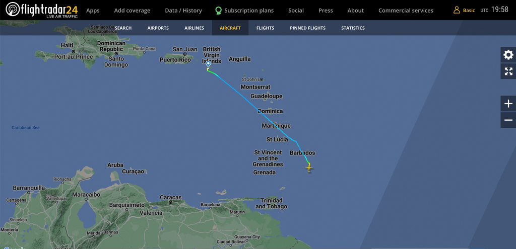
Route of the flight.

Profile of the flight. NOTE: The first 5 minutes of the blue line
flying at an altitude of just 950 feet.
I know that this not important, but unusual.
Here in Barbados we are fine so far, just a
little above normal winds and here and there a shower, some of
them hefty but short lived. However, the CPA (Closest Point of
Approach) is still to come, around 21:30 tonight. We also have a
good portion of water out there coming towards us.
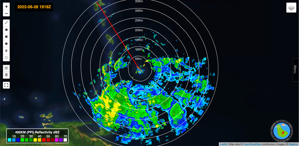
Barbados Weather Service Radar image (Barbados in the centre
of circles).
So much for today. May you all have a good night.
--
Best regards and stay safe and COVID-19 free! Keep your distance!
Jurgen
Barbados South, near airport (BGI)
|
|
- Latest CAP warning, Hurricane Hunter found storm force winds
|
- By Jurgen Starck <weather at turtle48.de>
- Date: Mon, 27 Jun 2022 15:55:38 -0400
|
|
Good afternoon to all,
Here is the latest CAP warning from this morning. For further
explanation please read my last post from yesterday.
The Hurricane Hunter is on the job
According to the NHC the Hurricane Hunter has found storm force
winds while investigating INVEST 94L. Excerpt: "... A NOAA
Hurricane Hunter aircraft is currently investigating the system
and has found winds to tropical storm force....".
--
Best regards and stay safe and COVID-19 free! Keep your distance!
Jurgen
Barbados South, near airport (BGI)
|
|
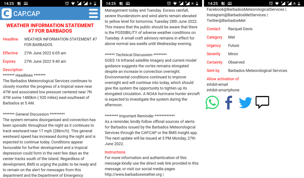
- For a purpose, I repeat what I have posted long ago
|
- By Jurgen Starck <weather at turtle48.de>
- Date: Sun, 26 Jun 2022 20:26:26 -0400
|
|
Last post for today, promise,
I am posting this for a reason (again). It seems, that the Barbados
Weather Service (BWS) is currently posting more detailed
information about what we know about INVEST 94L, compared to
what the NHC is reporting. I also want to advise everyone to
install and/or register for the CAP or CAP.CAP app (for
smartphones only). CAP stands for the COMMON ALERTING PROTOCOL,
which is an international standard protocol for emergency
news/earnings/alerts messaging. I know that the advices and
warnings which I am getting are mainly centred on Barbados, but
just like in this case (INVEST 94L), the information may be
sometimes also useful to my fellow islanders because of the size
of those systems. What is important to know about this, is that
those messages are provided by local authorities in general. Which
means, that you need to subscribe for a country from where you
want to receive those warnings or alarms, in case the country
where you are living may not have the means to provide such
information.
Since the CAP app is working via internet and SMS you probably
can receive these information from anywhere, as long you are
connected to the internet or your phone network. It works on
smartphones, and computers via various ways. Such as an app that
you can download on your mobile phone. On your computer you can
get the same information via email.
Think about it. Then again, if you may find out it is not
covering sufficient information for your needs/location, you can
always delete it and cancel your account.
I gone now. Not coming back tonight, for sure. Good night to
everyone! 😉
--
Best regards and stay safe and COVID-19 free! Keep your distance!
Jurgen
Barbados South, near airport (BGI)
|
|
- The "harbinger wave"
|
- By Jurgen Starck <weather at turtle48.de>
- Date: Sun, 26 Jun 2022 17:59:24 -0400
|
|
Good evening again,
I had just posted the hurricane hunter and shortly after, a
decent rain from a "harbinger Tropical Wave" which is NOT
connected to INVEST 94L just released part of it's heavenly gold
a.k.a. rain! That was a good downpour and on satellite photos
(like stormcarib's front page or below) it looks like that the
Leeward Islands may get some of this as well. Crossing my fingers
for everyone out there who had less rainfall rather than Barbados
has had in recent months. And with the threat of droughts going on
as predicted by scientists, I guess, all of us have to increase
our own (private) water storages and catchment areas wherever
possible. Sounds easy, I know, but it is not that easy, know that
too. We need to get more creative... But how?
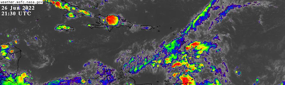
The "harbinger wave" on satellite photo.
--
Best regards and stay safe and COVID-19 free! Keep your distance!
Jurgen
Barbados South, near airport (BGI)
|
|
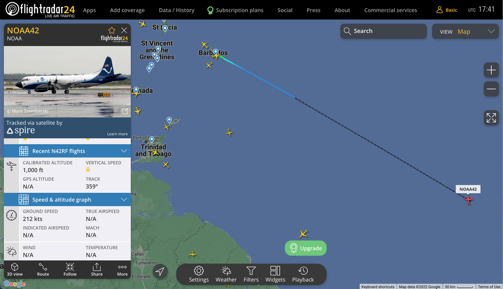
- Hurricane Hunter
|
- By Jurgen Starck <weather at turtle48.de>
- Date: Sun, 26 Jun 2022 16:45:31 -0400
|
|
Good evening to all,
at 16:08 o'clock a NOAA "Lockheed WP-3D Orion" Hurricane Hunter
landed in Barbados. I guess we all know what it's purpose/mission
might be, don't we.

NOAA "Lockheed WP-3D Orion" Hurricane Hunter, nickname "Miss
Piggy".
--
Best regards and stay safe and COVID-19 free! Keep your distance!
Jurgen
Barbados South, near airport (BGI)
|
|
- Tropical Wave
|
- By Jurgen Starck <weather at turtle48.de>
- Date: Sat, 11 Jun 2022 11:47:19 -0400
|
|
Good morning to all,
yesterday a Tropical Wave was passing through the Lesser Antilles
island chain. It has brought a fair amount of rain during on and
off showers. Most of the action started before midday and it ended
around sunset. The Barbados Weather Service (BWS) predicted an
accumulated rain fall of 20mm and winds peaking at 55 km/h and
higher gusts near showers. My personal experience can confirm
that.
Sad news for the Leeward Islands: There is not much rain in for
you, according to the two BWS radar pictures (this is meant to be
a reply to Isabel from St. Croix and all other interested
parties).
Looking South: Where the clouds are dark and low at the
horizon a strong thunderstorm was scaring the fish. It also
affected air traffic, see screenshots further down below.
The rain is here, I had to move inside.

The horizon invisible, due to dust haze and rain.
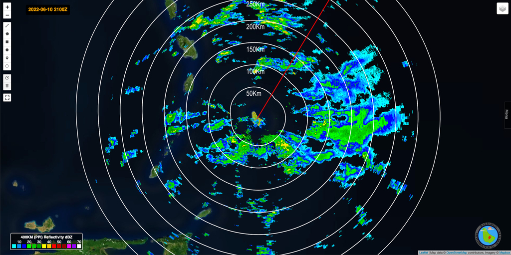
BWS Radar: This shows about all of the action. There was
almost nothing further north.
Affecting air traffic
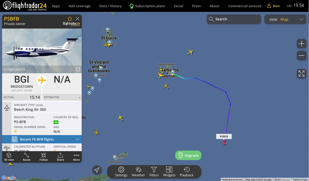  
Aircraft avoiding bad weather. Everyone tried to bypass the
thunderstorm.
The show is over
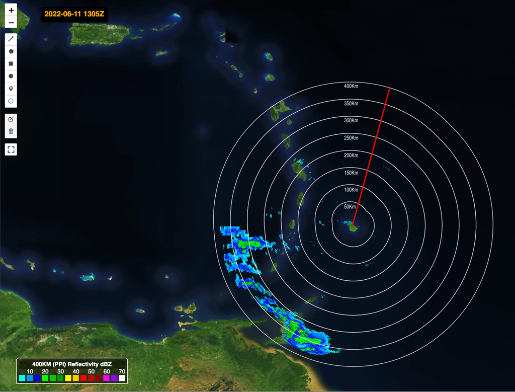
Radar image as of 09:05 AST of this morning: Larger area of
the radar image shows not much rain in the north.
However, the north is partially out of the radar's range. Hence,
I am going to cross my fingers, that you might get some rain up
there.
I also have attached two short videos. I guess, they are speaking
for themselves.
That's it for today.
See yuh.
--
Best regards and stay safe and COVID-19 free! Keep your distance!
Jurgen
Barbados South, near airport (BGI)
Attachment:
20220610_161434_The_wind_is_here_no608500.mp4
Description: video/mp4
Attachment:
20220610_161434_Steamroller_no608501.mp4
Description: video/mp4
|
|
