 |
Caribbean Hurricane Network
- 2 0 1 6 Season - |
|
|
|
2016 Atlantic Hurricane Season |
|
| Alex | Bonnie | Colin | Danielle | Earl | Fiona | Gaston | Hermine | Ian | Julia | Karl | Lisa | Matthew | Nicole | Otto | |
The 2016 Atlantic Hurricane Season was an above average season with 15 named storms, 7 hurricanes. There were 4 major hurricanes, Gaston, Matthew, Nicole and Otto. Matthew (the only Category 5) was the most destructive one, esp. in Haiti, where over 500 people were killed. Nicole made landfall in Bermuda as a Category 3 storm, causing some damage, but much less than anticipated since iNicole was a Category 4 storm just before making landfall (see image below of Nicole's eye approaching Bermuda). Late season storm Otto caused major problems in Panama and Costa Rica. Because of their impact Matthew and Otto will no longer be used in the 6-year rotating list of names. They will be replaced with Martin and Owen for the 2022 season.
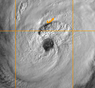 |
| - - - Nicole approaching Bermuda - - - |
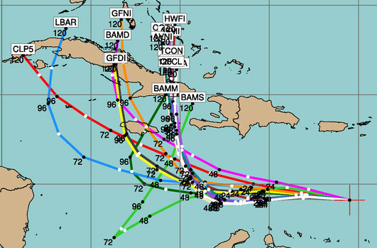
Following is an archive of all weather discussions Dave and I posted. They are in reverse chronological order, with the most recent storm discussion on top. If you want more background in formation on specific storms, I have found the 2016 Atlantic Hurricane Season section in the Wikipedia a great resource. Also, visit the Hurricane Research Division of NOAA's Atlantic Oceanographic and Meteorological Lab for 'best track' data of all 2016 storms. The track map below is from that website as well.
- - 2016 Hurricane Tracks - -
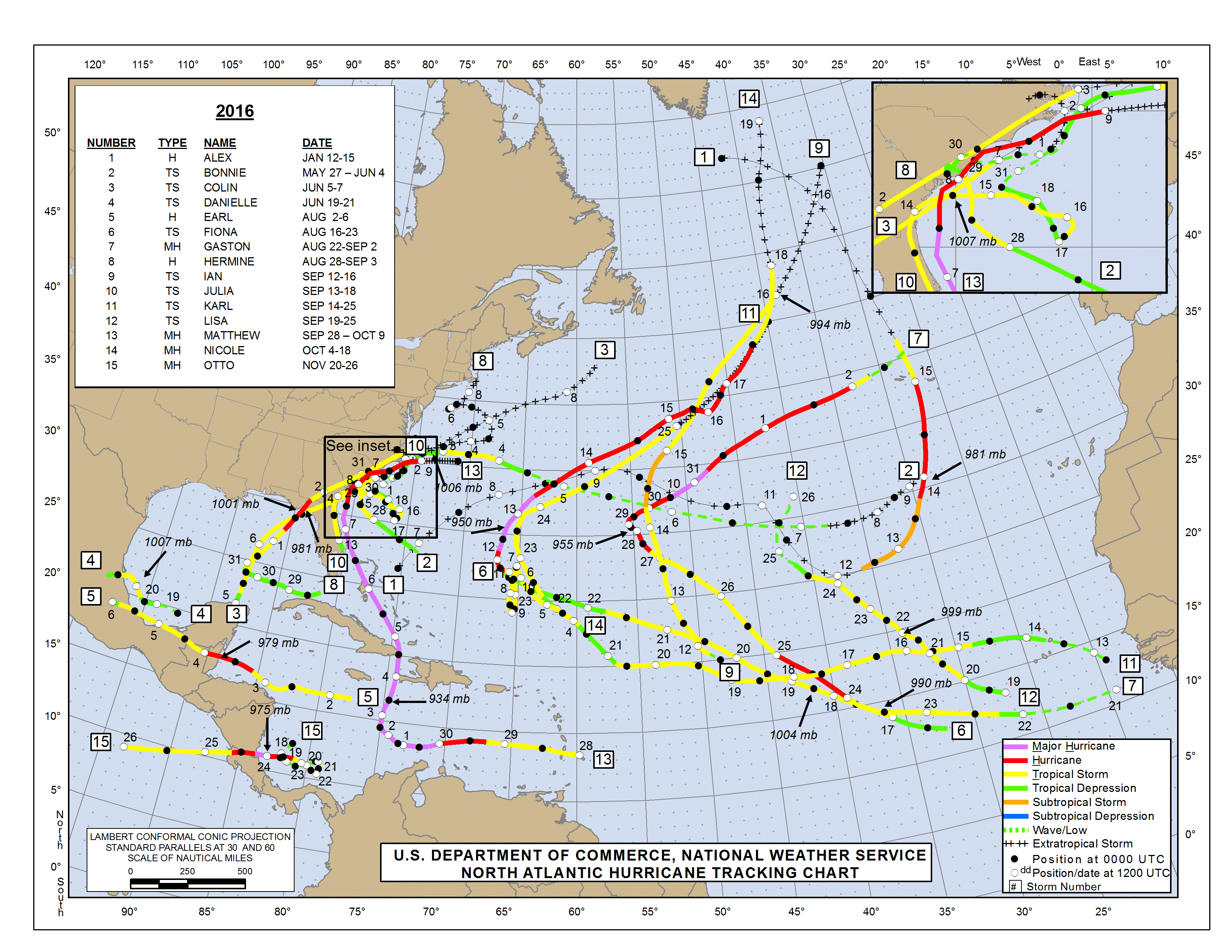
- - Source: NOAA/AOML Hurricane Research Division (click on image for larger size) - -
Weather discussions by Gert & Dave during the 2016 Atlantic Hurricane Season. The homepage with the links to local reports from the islands, latest satellite image, 2016 weather outlook can be found here.
Monday, December 26, 2016 10:05AM EST
- Holidays
Good afternoon,

Been traveling. Happy Safe Holidays and a positive, prepared, storm safe 2017 to all!!

Dave

Sent from my iPhone
Thursday, November 24, 2016 10:17AM EST
- Wow Otto
-
Good morning,
Happy Thanksgiving to all those who celebrate and embrace this American holiday!
What's not so happy is the situation off the Caribbean coastline of Nicaragua and Costa Rica where dangerous Hurricane Otto, having finally decided it was time, is approaching the coastline and where the eyewall is expected to landfall this afternoon.
Currently at 110 mph, Otto has a few more hours to strengthen and might actually make major Cat 3 status. The eye is a pinhole 15 miles wide with TS force winds out to about 75 miles so Otto is a compact storm with a potent punch. The eye has cleared out the last few hours on both microwave and infrared satellite imagery suggesting strengthening so Cat 3 is not out of the question with a few hours left as he moves currently about 9 mph to the west and expected to pick up some forward speed.
Looking at the latest satellite imagery, Otto appears to have taken a jog to the south and might actually make a historic Costa Rican landfall; one never recorded since records began. But if the eyewall hits just a mile into Nicaragua, that record will still stand as it's where the eyewall actually strikes land is where it's official landfall is determined.
If there is a sliver lining, it is the fact Otto will strike a sparsely populated area of coastline including a nature preserve in Nicaragua. Needless to say, those who do live there are in for a heck of a ride. Heavy rains will also be a major player with life threatening flood and mudslides. This is a storm to be reckoned with and will undoubtably be destructive sadly both in property and human life.
Once Otto clears Central America, he is expected to die a slow death in the Eastern Pacific as wind shear and cooler waters will contribute to his demise.
TD Marce by the Phillipines, snow detected in Tokyo for the first time in like 50 years, and a probable, at landfall, major hurricane named Otto about to maybe make dubious, destructive history are all players this Thanksgiving Day. We have much to be thankful for.
Dave
Tuesday, November 22, 2016 14:45PM PST - Hurricane Otto
- Here we have a late season surprise, Hurricane Otto, although Dave had pointed out this stubborn weather system a week ago in the same area. It is expected to move to the west to make landfall at the Nicaragua/Costa Rican border. A hurricane this far south in the Caribbean is very unusual. It would be a first ever for Costa Rica. As is often the case, the rain associated with this system will be the biggest threat, locally 15-20 inch... Stay safe! -Gert
Sunday, November 20, 2016 10:51AM EST
- Caribbean Mess
-
Good Sunday morning!
Six days ago I posted about a possible "Otto" and today, I'm still posting about a possible "Otto" and the system is still in the same area as well!
Located off the coasts of Panama, Costa Rica and Nicaragua, 90L is still in a meandering, erratic moving state with no particular place to go. Steering currents have and continue to be weak but if it develops, it's rotation will take it somewhere, most likely into Nicaragua, according to the latest model trends.
On satellite this morning, it is not the blobbette that has formed south of Haiti and the Dominican Republic; rather the discombobulated mess in the extreme SW corner of the Caribbean. It doesn't have a large window in which to organize but it has a chance right now with above average SST's (Sea Surface Temperatures) and a good deal of moisture in the atmosphere with no dry air interference around. Only downside is wind shear, which is marginal but even that shouldn't hinder development with all the juiciness in the atmosphere.
So, as the front pulls away, maybe Otto will come out and play. But he won't play nice. Regardless whether it becomes TS Otto, reaches and stays at depression status, or doesn't become an organized system at all, life threatening heavy rains and flooding will affect Panama, Costa Rica and Nicaragua.
Closer to home, a lingering trough has produced very slow moving cells of heavy rainfall the last couple days although we are in a dry slot at the time. Even our cell phones sounded the flash flood warning yesterday. We are expecting heavy rains tonight into tomorrow and the ground is saturated on a very green island. While many of these forecasts do not verify, they are forecasts so that means the potential is there so keep aware.
Dave
Monday, November 14, 2016 09:38AM EST
- Maybe an Otto?
-
Good morning,
Things have certainly quieted down across the Atlantic as they are "supposed" to at this time of year but we have an interesting blob trying get it's mojo going SW of Jamaica. Looking more impressive from this mornings animated satellite pass, it now has appeared to have lost much of it's very deep convection around the middle but that most likely will be temporary. Conditions are conducive for late season development and the next batter up is Otto. As we still have 16 days left in the official Atlantic hurricane season, it's possible we could see a Paula although I think I'll take the under on that one.
Potential track of this slow to materialize system is looking just south or over Jamaica headed NNE then north to Haiti which doesn't need anymore tropical developments or a more westward track. It's too early to forecast an accurate track and these late season systems don't always cooperate with logic.
Dave
Sunday, October 23, 2016 18:09PM EDT
- 5 weeks to go
-
Good evening!
With only about 5 weeks left in the official Atlantic 2016 season, there is not much to talk about for the moment. A wave that seems to be taking it's sweet time getting to the eastern Caribbean is getting munched by wind shear streaming off South America while some of the low level moisture dots have escaped and have been giving the islands sporadic rain, clouds and high humidity enhancing the hungry mosquito hordes.
The Gulf of Mexico and the western Caribbean are a bit inhospitable as well while the Pacific might see a storm named Seymour who might "see" his way, as he falls apart in a few days, northeastward and contribute to some wet Pacific storm systems approaching a very droughtified California. It looks like those storms will be good news for central and northern California and a wait and see for SoCal.
I still see one more named system in the Atlantic this year before all is put to rest and hope it is a fish storm as well! There still might be an Otto yet!
Dave
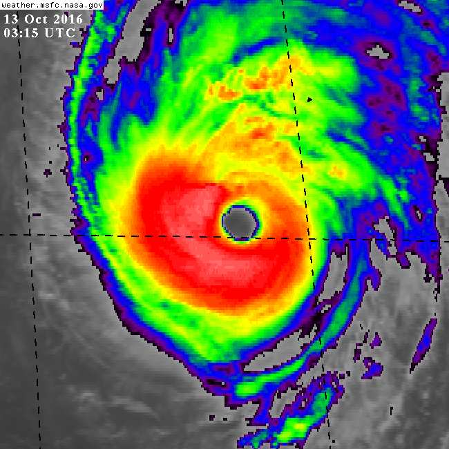
Thursday, October 13, 2016 20:50PM PDT - Bermuda
- Bermuda got the eye of Nicole. As was forecasted Nicole weakened to a Category 3 hurricane just before making landfall. First reports indicate extensive damage, with 85% of people at one point of time without power. However, it doesn't seem too bad, consdering getting a direct hit by a major hurricane... I am awaiting some reports from Bermuda by our local hurricane correspondents, but I can imagine they are prioritizing the cleanup! The Royal Gazette has some reports, esp. the 'live' section has lots of pictures. Below an impressive image of the eye of Nicole, which is bigger than the island! I have collected more high resolution satellite images at img.stormcarib.com.
Meanwhile the situation in Haiti is still dire. Right now the death toll stands at over 1300 and cholera is spreading in the hard hit southwest region. And with crops destroyed the future looks pretty bleak. More news on Google News. USA Today has a How you can help webpage... -Gert
Wednesday, October 12, 2016 20:50PM PDT - Category FOUR
- Nicole is now a Category 4 storm. A lot stronger than ever forecasted. Right now it is only about 185 miles from Bermuda and is expected to pass just 12 miles to the east tomorrow. We always say, Bermuda is so well prepared, houses are well built, etc. But a Category 4 storm is still a Category 4 storm, where ever you live! This is how a Category 4 is described on the Saffir Simpson Scale:
Shrubs and trees blown down; all signs down. Extensive damage to roofing materials, windows and doors. Complete failures of roofs on many small residences. Complete destruction of mobile homes. Flat terrain 10 feet of less above sea level flooded inland as far as 6 miles. Major damage to lower floors of structures near shore due to flooding and battering by waves and floating debris. Low-lying escape routes inland cut by rising water 3 to 5 hours before hurricane center arrives. Major erosion of beaches. Massive evacuation of all residences within 500 yards of shore possibly required, and of singlestory residences within 2 miles of shore. Example: Hurricane Andrew (1992)
Right now the forecast has Nicole weaken to a Category 3 storm before it reaches the island. Hope that holds true. Below the latest satellite image. The little speck to the north-east of the eye is Bermuda... (see the 'image' and 'loop' options above in the Tools section.). Stay safe! -Gert
Wednesday, October 12, 2016 09:00AM EDT
- Nicole plus
-
Good morning!
Just returned from a few chilly mornings in upstate NY where the fall foliage is in full, beautiful swing (something that doesn't happen in the tropics) and back in the hot and muggy VI.
While some areas are cleaning up from Matthew and others will be dealing with his after effects for some time as in NC flooding, there are many who will take this storm as a test of whether to evacuate the next time or not. Folks, mandatory evacuation means just that. It's your life. Plus the lives of those you dial 911 for help when you shouldn't even be there in the first place. If Matthew had been 10-30 miles closer to the coast, the damage would have been exponential and you, along with your fellow non evacuating friends, might not be here today. The EWRC, which occurred as Matthew approached the coastline and are difficult to forecast, I believe saved the day and lives in Florida.
On to Nicole. Hurricane Nicole wasn't supposed to be a hurricane. Heck, she wasn't even supposed to develop into a mere depression. But, fighting the odds as in 25-35 mph wind shear, she persevered, trundled around a bit as if waiting for Matthew to get off the stage, and is now poised to strike Bermuda head on as a formidable, probably major hurricane. Hurricane hunter aircraft are investigating right now and with low wind shear and very warm waters, I expect Nicole to reach that major status shortly. Thankfully for Bermuda, experience here is extensive with tropical systems and the building codes are strict. Bermudians are well equipped to ride out hurricanes but yes, even they will suffer damages from wind and storm surge. Nicole is expected to become a powerful extra tropical system after it visits Bermuda on its way to Europe.
Computer models are hinting at tropical formation in the Western Caribbean/southern GOM within the next two weeks which could result in our next hurricane or just a strong low pressure system. track wise to early to tell but a possibility is movement towards the US Gulf Coast. Lots of thunderstorm activity, low wind shear, and lower barometric pressures in the area will be enhanced by a westward moving tropical wave around 62W and will be something to watch in the coming days.
Winding down the Cabo Verde season, there are a few waves across the eastern Atlantic but show nothing in the way of organizing. The one closest to the African coast has a 1008mb low embedded but is entrapped by the monsoon trough and will be of no consequence unless it escapes.
I have to mention the Pacific as Super Typhoon Songda will be racing across the Pacific on a rather strange, almost beeline for the Pacific Northwest and will bring potentially catastrophic winds and heavy rains to the Oregon/ Washington coasts and have damaging impacts on the beautiful San Juan Islands and Vancouver Island Friday and Saturday. Batten down the hatches!
Dave
Monday, October 10, 2016 13:34PM PDT - Nicole
- While we are all still in post-Matthew mode, there is still another storm out there, Nicole. And this one is aiming directly at Bermuda. Their second this year! Right now it seems to be struggling a bit, but it is expected to be a hurricane by the time is reaches Bermuda. Its Closest Point of Approach with Bermuda will be reached Thursday. Stay safe. -Gert
Saturday, October 8, 2016 12:50PM PDT - No loop
- Now that Matthew made landfall east of Charleston, South Caroline it has weakened a lot. Also, the new forecast doesn't show the loop back to the Bahamas anymore. Great! It might still happen, but just as a broad area of low pressure...
As an aside, I have a collection of high resolution satellite images on my website showeing Matthew from 'start to finish' at img.stormcarib.com. -Gert
Friday, October 7, 2016 14:42PM PDT - Haiti
- The death toll in Haiti keeps rising, now at over 800... Most people killed were in the south-western coast where the eye went over... Communication is still bad so I won't be surprised if the death toll will reach 1000. If you can help out, The Weather Channel has a list of charities to which you can donate money. It also includes UNICEF, that I have listed before. Another good charity in my opinion and to which I just donated to, is Fonkoze, a 'microfinance' institution. In case you need some convincing to donate, just read some of the news reports (Google News).
Meanwhile, Matthew is battering the US coast, now finally downgraded to 'just' a Category 2 storm. It is expected to do a little loop, and might go over the Bahamas again! But this time just as a depression. Would be nice to wash all the salt away... In any case, some areas in the Bahamas are hard hit. I am trying to get some reports, but have not been very successful so far, probably because of widespread power outages.
And finally speaking of donations, I have stopped my donation drive. With the advertising income I should now have enough for the year. Thank you so much to all who donated! -Gert
Thursday, October 6, 2016 09:40AM PDT - Haiti
- Unfortunately the first reports from Haiti are not good. The Washington Post just reported that the death toll in Haiti is more than 100 people... On top of this there is a high risk of cholera spreading through the affected areas. Reports from the eastern part of Cuba are not good either...
Right now, Matthew just passed New Providence (where Nassau is located), Bahamas. The storm had weakened a bit but is now a Category 4 again. The eye seems to be over Nicholls Town, Andros Isl. now... Then the eye will pass only about 20 miles east of Freeport (Grand Bahama). Not good at all.
After the Bahamas, Florida is next. Although right now it seems that the eye will stay just offshore, keep in mind that this is a big storm! There will be extensive damage. Please, heed the warnings of the local agencies! For people in Florida (and rest of East Coast) you can use the 'Closest Point of Approach' tool as well. I have listed the latitude and longitude from a number of cities which can be easily entered in the form. As always, don't only focus on the track. You can overlay the image with the latest satellite image, and then you will see how big of an area will be affected by this storm... Also, hurricane forecasting is not an exact science, there will be deviations to the track, which could bring the eye inland at random places.
Lastly, there are a lot of rumours going around that Hurricane Matthew will make a loop and hit the Bahamas (and Florida) again. While some models certainly indicated that, they also show that at that time the storm will have weakened a lot to barely a tropical storm. However, there will still be a lot of rain associated with the system. There is also a lot of uncertainty with forecasting that far in advance. So don't panic about this yet! -Gert
Wednesday, October 5, 2016 09:06AM EDT
- Dangerous Matthew
-
Good morning from Upstate NY,
After a disrupting interaction first with SW Haiti and the easternmost mountains of Cuba, hurricane Matthew has emerged a bit battered but resilient as ever. Downgraded to a Cat 3 with winds of 115 mph, Matthew sets his sights on the entire Bahamas nation of over 700 islands.
While the Turks and Caicos have largely been spared serious storm surge and wind damage according to reports, the same cannot be said for Haiti and to a lesser extent Cuba. A major bridge was washed away in Haiti cutting off communications to many areas and accurate damage assessments are hard to come by and verify. But in reality, catastrophic damage has occurred and the aftermath will be worse.
Back to the Bahamas, the forecast is potentially grim as Matthew is expected to re intensify into a Cat 4 with the distinct possibility of another rapid intensification event. The ingredients are there for the re intensification and possible RI: low wind shear, high SST's, no dry air intrusion, and the fact the Bahamas are basically an island nation sandbar topography wise with no mountainous terrain to interrupt. Winds and large storm surge will be the dangerous and destructive components.
Next up, the east coast. Its a given the east coast from FL to NC will be impacted, some areas more severely than others. If RI occurs, the effects will be much worse as a strengthening hurricane approaches the coast. Current track spares the NE as a trough is expected to curve Matthew out to sea by the OBX. This however, puts Bermuda into play.
One interesting and potentially bad scenario has Matthew looping back towards the east coast as TS Nicole interacts as a fading system. Lets hope not.
Speaking of Nicole, she will fade soon due to very high wind shear while another tropical wave is showing some life. But all eyes are on Matthew.
Be safe, smart, and prepared.
Dave
Monday, October 3, 2016 13:35PM PDT - Extreme Hurricane Matthew
- There is not much to say anymore, Matthew is still a Category-4 storm and we know where it is going. It is even moving a bit more to the east. Good for Jamaica, bad for Haiti. The eye of Matthew is actually expected to move over (or very near) Haiti tonight. After it crosses Cuba Matthew will move still as a Category-4 storm into the Bahamas... The hurricane force wind is not the only threat. More people are killed by water; the rainfall and storm surge. A huge threat with this storm, not only because of its size, but also because it is moving northward so slowly, dumping more and more rain at the same location... The following is taken from the advisories, very frightening...
RAINFALL: Matthew is expected to produce total rainfall amounts in
the following areas:
Southern Haiti and southwestern Dominican Republic...15 to 25
inches, isolated 40 inches
Eastern Cuba and northwestern Haiti...8 to 12 inches, isolated
20 inches
Eastern Jamaica...5 to 10 inches, isolated 15 to 20 inches
The Bahamas...8 to 12 inches, isolated 15 inches
Turks and Caicos Islands...2 to 5 inches, isolated 8 inches
Northeastern Haiti and the Dominican Republic...1 to 3 inches,
isolated 5 inches
Western Jamaica...1 to 2 inches
Life-threatening flash floods and mudslides are likely from this
rainfall in southern and northwestern Haiti, the southwestern
Dominican Republic, and eastern Cuba.
STORM SURGE: The combination of a dangerous storm surge and large
and destructive waves could raise water levels by as much as the
following amounts above normal tide levels...
Southern Coast of Cuba east of Cabo Cruz...7 to 11 feet
South Coast of Haiti...7 to 10 feet
Northern Coast of Cuba east of Camaguey...4 to 6 feet
Jamaica...2 to 4 feet
Gulf of Gonave in Haiti...3 to 5 feet
Southern coast of the Dominican Republic...1 to 3 feet
The Bahamas...10 to 15 feet
|
You can already donate to UNICEF to support their Matthew relief effort. I just did. Donate to UNICEF.
-Gert
Sunday, October 2, 2016 19:26PM EDT
- Calamitous Matthew
-
Good evening,
Hurricane Matthew I fear will be one for the ages. Currently on a very slow NW trek towards Jamaica and expected to turn to a northern track soon, Matthew is expected to remain a major hurricane as it's forecast to thread the needle of water passage (only 50 miles wide) called the Windward Passage between Haiti and Cuba possibly avoiding direct interaction eyewall wise with the high mountainous terrain of both countries.
Jamaica, being on the western side of the storm if Matthew follows track guidance, will get a severe lashing, heavy rain squalls which have already started, TS to hurricane force winds and storm surge. Haiti, on the much stronger east right quadrants side, is in a terrible spot. Not only will they get the full brunt of the storm wind wise, the torrential tropical rains will be almost biblical in nature. The infrastructure, deforested landscape, and the amount of people who have little or nothing in addition to those still living in temporary shelters from the earthquake all form a recipe for an event of catastrophic proportions. Another ingredient in this disastrous mix is the heavy convection laden blob anomaly seemingly attached to Matthews right hip. This will do nothing but enhance the downpours and storminess in Haiti and the western side of the Dominican Republic if it remains throughout the next few days.
Once through the Windward Passage, again if the forecast track remains intact, the low lying islands of the Turks and Caicos are on deck for a Cat 3 Matthew. Again, on the eastern, right side quadrants of Matthew, they would see devastating effects. The Bahamas would see very similar effects if this course holds true as Matthew moves north, especially with very low wind shear forecast and energy rich waters.
So, Florida, you think you might appear to be out of the woods but hold on there. Your not. The margin of 3-5 day errors in track and intensity are quite large and the NHC is adamant that you know that. Savannah, Charleston, Wilmington, the OBX, your not out of the woods either. Actually you could be in the crosshairs. Basically if you live along the east coast pay attention and be prepared. This storm is not playing games. It's a very serious threat. We will have a better idea tomorrow night/Tuesday how the upper atmospheric conditions will influence Matthews track and intensity.
The coast of Africa is still spitting out some waves and we are still in the heart of season so all bear some attention.
Meanwhile, 98L, to the NE of the Lesser Antilles, has been beaten up by Matthews outflow and is doubtful to reach named status. If it was to intensify, it would help pull Matthew away from the east coast so a saving grace may be there. Don't count on it.
Dave
Sunday, October 2, 2016 09:33AM PDT - The big one
- Matthew was a Category 5 for a little while yesterday, and it still a powerful Category 4. The forecasted track shows that it will move in between Jamaica and Haiti crossing Cuba into the Bahamas. Impacts will be felt later today and tomorrow. With the bulk of the storm on the eastern side, Haiti will be hit hard (and the Dominican Republic will certainly feel Matthew's impact as well). The wind will by far not be the biggest problem. This quote from the advisories is very frightening:
RAINFALL: Matthew is expected to produce total rain accumulations of
15 to 25 inches over southern Haiti, with possible isolated maximum
amounts of 40 inches. Across western Haiti, expect total rain
accumulations of 8 to 12 inches with isolated maximum amounts of 16
inches, while northern sections of Haiti can expect lower amounts
in the 1 to 3 inch range with localized maxima near 5 inches.
Matthew is expected to produce total rain accumulations of 10 to 20
inches over eastern Jamaica, the Dominican Republic, and eastern
Cuba, with possible isolated maximum amounts of 25 inches. This
rainfall will likely produce life-threatening flash floods and mud
slides.
|
-Gert
Friday, September 30, 2016 17:00PM PDT - Category 4!
- This afternoon Matthew was upgraded to a Category 4 Hurricane, now packing 150mph winds (Category 5 [the highest] is 157mph and more, so this is a strong Cat-4). Jamaica, Haiti, Cuba, Dominican Republic, prepare now for the big one! Each forecast the track seems to be a little more west, so esp. Jamaica, you have got one coming! Get your stuff together, Sunday it will start people in Jamaica! -Gert
Friday, September 30, 2016 08:37AM EDT
- Cat 3 Matthew?
-
Good morning!
I was going to post last night but, frequently as it does, travel times do not cooperate. Hence this morning from MIA.
Defying the area of the Caribbean Sea north of South America and the ABC Islands that is known as the "graveyard" of intensification, hurricane Matthew pulled a rapid intensification surprise overnight by making a slow dive to the WSW avoiding a moderate to strong wind shear alley and taking advantage of untouched warm energy filled waters. Now a strong Category 2 hurricane with 105 mph winds, Matthew is expected to continue on this course for about 36 hours and by days end reach major Cat 3 status which I expect by 2 pm and maybe even 11 am.
This forecasted dive to the WSW has actually caused a rare occurrence: tropical storm watches for the ABC islands of Aruba, Bonaire and Curacao and an even rarer occurrence; the issuance of a tropical storm watch for the northernmost point of Columbia.
Between the high ridge to the NE and a cutoff low (spun off from the jet stream) to the NW, Matthew is expected to begin a turn sometime Saturday into Sunday towards the northwest and then north somewhere around 76-77W. As of late, models have been trending more west before the turn.
There is high uncertainty at this point where this turn will occur and even more so with the intensity forecast. Lets just say, Jamaica, Central and Eastern Cuba, Haiti, Turks and Caicos, Bahamas, both coasts of Florida, the Gulf of Mexico, and the Eastern Seaboard are all in play at this moment. That's trek wise. Even the Caymans can get in on the action depending on how far west Matthew goes before turning. Intensity wise I look for Matthew to be a Category 4 before all is said and done. Another period of RI or rapid intensification is not out of the question due to the energy rich and deep waters surrounding Jamaica and the Bahamas while land interaction will be a key player in both intensity and track down the road which is both good and bad. Good at knocking a system down. Bad at the heavy rain and flash flooding potential, especially for Haiti.
Be safe, be prepared and look out for your neighbors.
Dave
Thursday, September 29, 2016 09:27AM PDT - Matthew weaker?
- Maybe it is true about the hurricane graveyard north of South America... Matthew is coping with some high wind shear and some dry air. It is definitely looking less organized than yesterday. Despite this it is a huge storm, almost covering the whole Caribbean Sea! Sea surface temperatures are plenty warm for further development and wind shear will get lower by Saturday. So in short, there might be some weakening today, but it is expected to slowly strengthen into a hurricane somewhere tomorrow, maybe even a Category 2 in 4 days. 10:45AM PDT Update: I was wrong, Matthew has just been upgraded to a hurricane. The Hurricane Hunters investigated the storm and found winds near 75mph.
I have received many reports by our special hurricane correspondents on the islands when it passed through the island chain (see list on the right), and so far they did seem come out ok. Luckily not what Tropical Storm Erika did last year to Dominica. Currently the only tropical storm watches (which is better than a warning) are up for the ABC-islands, which don't see a tropical storm that often.
Where will it go? Matthew is expected to make a strong turn to the north. Most of the models (and the National Hurricane Center) predict it to go east of Jamaica, making landfall in Cuba, just passing west of Haiti. If the turns comes later, or less sharp (what some of the models indicate, see below) the Cayman Islands could be in Matthew's path as well. So for sure heed the Cone of Uncertainty (see above). If you are in it, prepare now! You can also use the Closest Point of Approach-tool to see how close and when the storm can get to you. But remember, this is a big storm, so don't focus on the track alone. Also, forecasting hurricanes is not an exact science, not only its track, but more so its intensity. We have seen it many times before that a storm can become much stronger than expected, esp. since water temperatures are quite warm in the Caribbean. Be prepared, stay safe! -Gert
Wednesday, September 28, 2016 14:06PM EDT
- Matthew
-
Good morning from the rain forest!
97L took a little longer to consolidate the center of circulation and close it off with the result now TS Matthew. Currently just SE of St. Lucia, Matthew is chugging his way through the Windward Islands at a rather quick 21 mph with 60 mph winds in certain cells.This will bring squally rain bands, some serious thunderstorms, flash flooding potential and minor wind damage.
TS Matthew is a rather large storm and its effects will be from the corner of South America all the way to the NE Lesser Antilles. Just how potent these effects will be depends on the slot of dry air ahead of Matthew, its forward speed, and wind shear coming north from South America.Once through the islands, Matthew will enter a traditional burial ground for tropical system development. If Matthew had entered this area as a wave, it would have been hard pressed to attain any status. However, it is entering this "dead pool" as a strong TS which means he will survive the passage, looking forward to more embracing conditions ahead. Not to say he might diminish in strength a bit first after the island passage but chances of him going poof are very small.
After menacing the islands and reaching the central Caribbean, computer models have a wide array of potential tracks. One thing they almost all agree on is a rather abrupt turn to the N to NE. What they can't agree on is the actual timing of the turn which is critical to who gets what effects wise. That's why they are called spaghetti models.
Matthew is expected to slow down dramatically and become a hurricane by Friday, eventually reaching Cat 2 status. Quite possibly, very warm waters and a great depth of them west of Jamaica could lead to rapid intensification, if Matthew trends that far west as some spaghetti models reflect. Three scenarios. One, Matthew never turns and plows into Mexico as a serious hurricane. Plausible but unlikely. Two, turns north, east of Jamaica, ravishes Haiti and to a lesser extent the DR and eastern end of Cuba eventually plowing through the Bahamas before heading out to sea. The third is the worse of the three. Matthew turns north on the west side of Jamaica thereby subjecting Jamaica to a serious pounding for hours on approach, right turn Clyde and exiting all while collecting strength from those rich energy laden waters on the west side. Trekking then over Cuba, Matthew could then take a far eastern GOM trek, a direct SE Florida head on strike, or a jaunt up the east coast.
Only time will tell when this expected turn will occur. As stated, this timing is critical to many in the potential path so no matter where you are, you need to be prepared. Florida Keys, either scenario is not good for you either so pay heed.
While all eyes are on TS Matthew, the next wave that splashed down off Africa should not be ignored. Potential is apparent here according to preliminary models and satellite pass overs.
I'll post tomorrow night when I reach the CONUS. Be safe all!
Dave
Tuesday, September 27, 2016 09:07AM PDT - 97L
- 97L still apparently has no closed circulation so hasn't been upgraded to a cyclone just yet. Hurricane Hunters are going to explore the system this afternoon, so we will know more soon. Even if it isn't upgraded people living inside the cone (see below) should prepare for some bad weather. The outer bands will be over Barbados and beyond later today...
Where will it go after it crosses the islands? Will it fall apart in the 'hurricane graveyard' north of South America, or will it strengthen more? Models (see above) seem to indicate that this system will become a hurricane (Matthew) within 72 hours, maybe even a Category 3 in 5 days... Its forecasted path is a little unsure to me. On one hand some models indicate an almost 90 degrees turn to the north in three days, making it a big threat to Hispaniola, and esp. Haiti. Other models show the turn later and less sharp, making it much more a threat to Jamaica and the Cayman Islands. So quite a big spread. We have to keep a close look on this system. Hopefully Dave can chime in a little later as well when he has decent power and internet and not consumed too many Cacique Guaros. -Gert
Monday, September 26, 2016 20:25PM EDT
- Almost Matthew
-
Good evening,
This comes from The Manga Rosa Hotel, located against the backdrop of a national rain forest in rainy season Costa Rica where internet, texts and mail can be quite challenging so this will be short.
Soon to be designated Matthew, 97L continues to slowly get its act together as has been forecast so far. While looking ominous at the moment as a large swirling monster, a closed center of circulation has not been detected, hence no designation. I anticipate this to be done by the 5 pm advisory tomorrow. Conditions such as SST's, wind shear and lack of dry air intrusion are all working in 97L's favor. What's not is it's continued proximity to the equator. That is slowly changing though.
The road ahead is full of uncertainty and usually I would discuss that but power fluctuating here due to tstorm so time to sign off for now. I will say this as far as projected path days down the road. From Mexico to the east coast are all in play.
Dave
Sunday, September 25, 2016 11:31AM PDT - Future Matthew
- New invest 97L, still about 1500 miles east of us, could pose a significant threat for the islands. Conditions are pretty good for it to become a tropical storm or even hurricane before it reaches the islands on Wednesday. As can be seen on the spaghetti-model plots above and schematic below the forecasted track takes it quite far south, and might even pass pretty close to the South America. We will have to keep a very close eye on this one in the next few days... -Gert
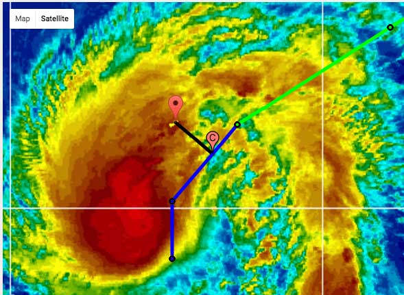
Friday, September 23, 2016 13:14PM PDT - Bermuda
- The center of tropical Storm Karl is expected to pass to the east of Bermuda within 90 miles later today and tomorrow. A lot closer than it seemed like a day or so ago. Luckily it is 'just' a tropical storm, although it looks pretty ominous (see picture below, a screen shot from the Closest Point of Approach tool). Tropical storm winds extend outward up to 115 miles, so within reach of the island. Luckily Bermuda is usually very well prepared, and houses are very well built, so I don't expect too many problems. Lots of rain, some wind, maybe a tornado, and big surf is what the advisories tell us. Stay safe Bermuda, don't do anything stupid when the storm passes over... Gert
Update 1:55PM: The new advisories show that Karl's center will now get as close as 70 miles to Bermuda (in about 13 hours). So the turn towards the east is occuring a bit later and the forecasted track is trending westward (closer to Bermuda) with each advisory... Also, Karl is slowly strenthening, it is a strong tropical storm and could become a hurricane within 24 hours while Karl is moving by Bermuda. The outer bands are already over Bermuda.
Thursday, September 22, 2016 14:54PM EDT
- Hostile Atlantic
-
Good afternoon,
So far this hurricane season we have seen numerous waves make the attempt to scale the tropical disturbance ladder from Invest, to TD, to TS and finally Hurricane. Even with warm and hospitable SST's, the combination of dry air, Saharan Dust and wind shear have all but evaporated their chances at hurricane stardom so far this year. Most have had decent chances according to the models and forecast projections but the dry air and windshear have been seriously underestimated, especially by the computer models.
So, now we have TS Lisa headed out NNE into the Central Atlantic; a lonely wanderer destined to wander soon no more as conditions will deteriorate rapidly against her and she will just become a remnant nuisance to the Azores.
TS Karl has had his share of battles as well and it continues, especially against the wind shear. If he can hold on, and win the battle, he just might make it to the pinnacle as a cat 1 hurricane but that is expected to be brief, if he does. TS watches are up for Bermuda as Karl keeps getting nudged farther to the east in the "cone' and could have some TS impacts within 48 hours which is like swatting a mosquito to Bermudians. Here in the Virgin Islands, Karl has sucked the air out of the atmosphere and the seas are glassy with little to no breeze and a shower or two passing by under mostly sunny and hot skies. You could almost skip a stone from Redhook to St. John!
Long term models hint at a possible disturbance in the GOM next week and has possibilities.
Off to our east is a wave that just splashed off the African coast and could be an interesting and possible major player down the road but given the history so far this year, only time will surely tell. However, it has splashed at a low latitude and is moving west and is expected to continue this trek. Being so close to the equator, it has no chance of spinning up at the moment so it will take some time to escape that grip and gain some latitude plus get into a more favorable environment. But if it does, someplace is gonna get an unwelcome visitor.
Dave
Monday, September 19, 2016 09:04AM PDT - Karl and almost Lisa
- Karl is doing what it is supposed to do and is staying clear from us. Hopefully it will stay clear of Bermuda as well. Karl might be a hurricane once it is close to The Rock. So we have to keep a close eye on this one still.
The invest in the far eastern Atlantic, number 96L will soon be upgraded to Lisa it seems. This system should not be a threat to us. Looking at the model spaghetti-plots (see above) it will curve nicely north well before it is close to us. -Gert
Friday, September 16, 2016 10:06AM PDT - Three named storms
- It seems like it has been a very active season so far, we are mid-September and already on our 11th named storm and we have 3 named storms right now. However, we apparently are only at about 75% of ACE (Accumulated Cyclone Energy) or total 'hurricane' activity. So not too many strong storms it seems.
Tropical depression 12 has been upgraded to Tropical Storm Karl. Right now it looks pretty good for the islands. The Closest Point of Approach calculator reveals that it will probably not come closer to the islands than about 400 miles (in about 5 days), but curve north of us. Also, it is not expected to strengthen much, though it might be a hurricane when it is closest to us. So we will keep a close eye on this one, but so far so good. -Gert
Wednesday, September 14, 2016 11:07AM EDT
- Mid September
-
Good morning!
Well last week I wrote about how quiet at the moment it was in the Caribbean and Atlantic and now we have a plethora of activity with three of four systems impacting land.
The closest to the Caribbean is quick spinup TS Julia, formerly known as 93L, who is menacing the Georgia and South Carolina coast right now with some tropical storm force winds and heavy rains. With a slowdown in forward speed anticipated, TS Julia could drop flash flood inducing rains over central Georgia and the Carolinas. These areas need rain per the weekly drought monitor but not all this, all at once. Just as quickly as she spun up, TS Julia will just as quickly spin down to a tropical depression later today and become a fleeting memory probably Thursday as a named entity since she will be crawling over the energy depriving landscape.
Ian, still a TS, is currently a threat to only shipping interests as he spins in the central Atlantic. Wind shear and cooler waters will be his demise and it's doubtful he will achieve hurricane status. No threat to the Caribbean or CONUS.
95L is throwing showers, thunderstorms and gusty winds at the Cabo Verde Islands off the coast of Africa and is given a high chance of development in the short term. Spaghetti models are in general agreement of a WNW track early but they become splintered after a few days with a few having this system dip to the south as it gets closer to the NE Caribbean. One to watch until it passes, goes and stays north. Conditions are conducive for development as well with good moisture levels, modest wind shear and warm SST's. Maybe 95L will follow TS Ian!
The last entity has not even been designated an invest yet as it currently is approaching the African coast but this wave already has the attention of the NHC and others. We are right in the heart of hurricane season and every spin bears attention as you have seen how quickly a low can ramp up aka Julia and wayyyy more impressively, Super Typhoon Meranti in the Far East Pacific who underwent rapid intensification yesterday to become another Godzilla of typhoons to menace Taiwan and China. Prayers to those in the line of fire there.
Dave
Tuesday, September 13, 2016 19:44PM PDT - Julia
- Invest 93L was just upgraded to Tropical Storm Julia. Its center is actually located on the mainland USA, north-eastern Florida, around Jacksonville. Julia will be short lived with no threat to the islands.
Meanwhile a new Invest (95L) is located a couple hundred miles east-southeast of the Cape Verde Islands. This might become Tropical Storm Karl within 48 hours. From the model-spaghetti plots it looks like it might pose a threat to the islands. Unlike Ian there is not a really northward component to its forward motion... Regardless, it will probably not be a big one. Even after 4 days the models indicate that it still hasn't reach hurricane strength.
On another note... I put up the Plea for Donations sign up again. Hope you can help. -Gert
Monday, September 12, 2016 09:00AM PDT - Ian
- Invest 94L that we have been following for a while has been upgraded to tropical storm Ian. At this point it is not expected to become a hurricane. Better yet, it is already at 21.8N (the islands are at about 18N) and moving northwest, so will pose no threat to the islands. It should stay about 600 miles to the east of Bermuda as well.
The other two invests (93L over the Bahamas and 92L in the Gulf of Mexico) have actually been 'downgraded', so no worries there either.
The Pacific is a lot more active however. Noteworthy is Super Typhoon Meranti, a storm that intensified very rapidly, in 24 hours winds increased from 85mph to 180mph! It is expected to clip southern Taiwan and make landfall in China. -Gert
Thursday, September 8, 2016 14:52PM EDT
- Quiet for the moment
-
Good afternoon,
With the demise of three week old former hurricane Hermine and once promising 92L, the Atlantic hurricane basin is fairly quiet for this time of the season which is good news!
We do have two potential sleepers to keep an eye on though as anything with a spin on it in September is worth watching. 93L was designated this morning by the NHC and is approx. 275 miles east of our northern islands moving WNW to NW at about 15 mph which in all likelihood carry most of it's heaviest rainfall and breezes to the north of the easternmost northern Antilles. However, an increase in showers and some tstorms is likely and will be more prolific if it flattens out more to the west than NW. Right now, it has a low chance of development according to the NHC due to moderate wind shear and copious amounts of Saharan dust coupled with only mid moisture humidity hovering around 50% at the mid levels. Four or five days down the road might be a different story for the northern Bahamas and the Carolinas.
About 650 miles to the SW of the Capo Verde Islands is a stronger wave which I expect to be designated shortly as 94L. This wave is also not expected to develop quickly, rather very slowly even, which usually means a more westward track as a weak system. Early next week the models show a good chance for development when conditions will be more favorable and that has the models pushing this into the Central Atlantic as a fish storm. I'm not buying that just yet and the cone of potential development has been shifted more to the west and that places the northern Antilles at the very tip.
The wave train continues right on cue on the African continent so lets be vigilant and prepared.
Dave
Sunday, September 4, 2016 17:54PM PDT - 92L
- 92L, a strong tropical wave is currently passing through the islands as can be seen on the satellite image above. It will continue mostly westward, with a tendency to the north later on, aiming for Jamaica. Still the environment is not very conducive to develop into a tropical storm. Even for the next 5 days the National Hurricane Center gives it a chance of only 30%. However, it will by causing a lot of rain and squally weather in its path.
A new contender is expected to come off Africa on Tuesday. We will see what that one is doing, but that one also has to cope with Saharan dust and dry air, so doesn't look to threatening yet. -Gert
Wednesday, August 31, 2016 13:15PM EDT
- The Saga
-
Good afternoon,
The drama queen formerly known as 99L as a toddler and now TD#9 as a teenager, looks to become a full adult by the 5 pm advisory if not the 2 pm as TS Hermine which means TD#8 will play second fiddle as TS Ian. However, while TD#8's window of opportunity is closing quickly, TD#9's finally blowing hers up.
Currently at a virtual standstill (moving about 2 mph per satellite imagery) in the central Gulf of Mexico, TD#9 is currently being investigated by the hurricane hunters who are enroute right now. There were no recon flights last night or this morning drawing the ire of many as the hunter squadron is maxed out with aircraft investigating the Pacific with Hurricanes Madelaine and Lester threatening Hawaii as well as TD#9 and TD#8 which has been dropped from the recon schedule.
There were many, including myself this morning that concluded TD#9 was a TS as of 8 am.
Needless to say, a caged storm in the Gulf has one way out: over land. Still expected to strike the west coast of Florida as a 65mph TS by most models and forecast, I can see this strike as a cat 1 or even a Cat 2 if she is found to have stronger winds at the center of circulation by the hunters shortly. Down the road, the east coast and NE might have an unwelcome Labor Day weekend visitor to their shores. One costing money, not spending it.
TD#8 as I mentioned has a narrow window of opportunity to make it to TS status and is headed away from the coast and out to the northeast. Resilient major Hurricane Gaston has a date with the Azores and Europe as probably a strong TS and extra tropical powerhouse respectively.
Back in our neck of the Caribbean woods, that gritty, reddish colored, haze inducing Saharan Dust has choked off what was the stepchild with promise known for a short while as 92L. This is very good news for the Caribbean and points farther west as it originally was forecast to become possibly another major player along the east coast and/or Gulf of Mexico after first ravaging parts of the eastern Caribbean. A shell of it's former self, the artist formerly known as 92L remains a tropical wave with a 1012mb low attached to it and while presumed defunct for the next 5 days, the possibilities of resurrection are probable once past 55W in some form. We are, after all, in prime time.
The next potential player is just about to emerge from the African coastline but not much has been mentioned of this one as of yet. Ghostrider, the pattern is full.
Dave
Wednesday, August 31, 2016 09:05AM PDT - Closest Point of Approach
- A very popular tool on my website is the "closest point of approach" calculator. With this tool you can find out how close and when the center of a storm will pass by your location. You can select from many of the Caribbean Islands. For people threatened by Tropical Depression Eight I have listed many locations on the East Coast, and for Tropical Depression Nine (now Hermine) for the Gulf Coast plus Atlantic side of Florida. The pre-filled form for Tropical Depression Eight can be found here and for Tropical Depression Nine (now Hermine) here.
For people in Florida's Big Bend area I saw this interesting article in the Washington Post titled Tropical storm could trigger dangerous storm surge and flooding in Florida by Brian McNoldy, a well known hurricane researcher and blogger. Stay safe! -Gert
Sunday, August 28, 2016 11:13AM EDT
- Hermine
-
Good Sunday morning all!
TS Hermine just finally might be classified today but not where most have been thinking the last 11 days as invest 91L, west southwest of Bermuda has upped the ante and will beat 99L to the punch as TD#8 as of the 11 am advisory.
TD#8 appears to be making a beeline for the Carolinas and is expected to pass by the Outer Banks on Tuesday as TS Hermine. I say pass by and not plowing into North Carolina as a trough is expected to swing down and turn the system back out to see. Since it was just classified, the models will now have a better chance at intensity and track path so more detailed information will be forthcoming soon. Coastal communities of the Carolinas should be preparing for TS impacts.
The enigma that is 99L, now in the Florida Straits, continues to defy expectations and confound experts and computer models alike. Once forecast to be a possible major hurricane impact on South Florida, 99L is a former shell of the system that passed over the NE Caribbean days ago as dry air and wind shear have taken it apart like Mr. Potato Head. However, it still stands a chance out in the Gulf of Mexico which could have serious consequences in the next days, especially with all of that untapped very warm waters to feed on. A slumbering giant just make awaken from it's coma. Hopefully this will not be the case.
Following in 99L's path is our next wave to roll off the African coast which is expected to splash on Tuesday. Looking formidable on land with extra convective bursts overnight, this wave is forecast already to develop rather quickly and might take the name Ian ahead of 99L. usually when systems form rapidly off the coast of Africa, they tend to curve towards the WNW and eventually become "fish storms" as they are commonly called. However, most of the long range models tend to have this wave splashing farther south and then moving on a more westerly track to the Caribbean. If that scenario play out, it will be trouble around the 5-8th of September for the Caribbean and possibly the US as it will not likely duplicate 99L's failures. More on this as time progresses.
Last but not least, the current king of the Atlantic, Hurricane Gaston, is poised to become a major hurricane within the next two days only 10 mph below Cat 3 status. Only a real threat to shipping interests, Gaston might make life rough for the UK coastline down the road as a potent extra tropical system.
Carolinas, the Gulf of Mexico, and down the road the Caribbean and even Europe are in play. If your not prepared now, better make it very soon. It only takes one.
Dave
Wednesday, August 24, 2016 18:54PM EDT
- trifecta
-
Good evening!
Having three entities to watch at the same time in August when many said August was going to be dead shows just how much Mother Nature thumbs her nose at those of "oh ye of little faith".
The never say die TS Fiona has finally paid her final respects but in dying, is helping to keep 99L just that; 99L. Looking like it was ready to pounce on the "named" stage today with an impressive convection burst overnight, 99L has been diminished somewhat into an elongated strong wave as it traverses the NE Caribbean. Some locations have had thunderstorm activity and copious amounts of lightning but not many. Mostly, the islands have received intermittent squally winds and rains due to the lack of organizational skills of such a broad system. The culprits of lack of skills: The ever omnipresent wind shear on the north side of 99L which has led to a dearth of anticipated rainfall amounts pushing most of the serious activity southward, sinking air due to the negative MJO Oscillation effect, and the seemingly ever present Saharan Dust which, at this point is now becoming a non factor.
As discombobulated as 99L is, enough remains to generate into a serious threat once the LLC (low level circulation) and associated stacked layers over it reach the Bahamas. By avoiding the mountains of Hispaniola, the LLC and associated contents of 99L will trek over the Turks and Caicos and arrive at a short stalling point off the South Florida coast. Shallow waters, SST's at a premium, low wind shear and a steering current most likely into South Florida and the Gulf of Mexico look to be the likely table setup. This is not cut in stone but the entire region should be on alert. Rapid intensification into a Cat 2 or more hurricane is a distinct possibility with little time to evacuate so there is an even more sense of urgency to prepare and supply.
if this scenario plays out, by crossing the Florida peninsula, it will be a caged animal in the Gulf as it will have to impact land somewhere. Sadly, it might impact Louisiana which definitely doesn't need any more rain much less a hurricane, revert back to Florida and the vulnerable Tampa area, the Panhandle or even as far as Texas depending on timing and steering. These are all plausible IF it goes Gulfwise. Lots of time and factors in between but not to early to pay heed. Even for those who think they know better.
TS Gaston has been an underachiever so far in the Central Atlantic and is now subject to high wind shear but still has a chance in a few days to make major status. Possible but unlikely as it moves into the open Atlantic. Some outlier models have Gaston missing his turn and moving west towards the east coast but again, possible but unlikely.
Back to the coast of Africa which not many are watching, a new wave is about to enter the fray.
Dave
Tuesday, August 23, 2016 10:17AM PDT - 99L
- As the satellite image above shows, there is a big mess coming towards the islands. It is not a depression yet, so windwise it should be ok. Also, the 'center' of the wave will move north of the island. Check out some of the reports by the hurricane correspondents who quote some local weather statements. It is expected to develop into something a couple of days from now, when it is closer to the Turks & Caicos and Bahamas. Models indicate that it will cross Florida into the Gulf. Hopefully not into Louisiana who just had unprecedented flooding.
Elsewhere, newly formed Tropical Storm Gaston will be a fish storm, and Fiona is on its last legs. Stay tuned... -Gert
Monday, August 22, 2016 08:27AM EDT
- 99L and very imminent Gaston
-
Good Monday morning!
It looks like 90L will beat 99L to the punch even though 99L has had it's chances and win the race to be named TS Gaston. Roughly 300 miles SW of the Cabo Verde Islands, soon to be Gaston is forecast down the road to become a major hurricane with no impacts on the Caribbean or the US mainland. While nothings impossible in Mother Natures arsenal, it does appear, at this time, that it will be a famous "fish storm" and curve into the Central Atlantic. That doesn't mean forget about it though as weirder things has happened. Just saying.
Closer to home, Saharan Dust snorting 99L is slowly organizing as the concentration of dust is waning and more favorable conditions of less shear, less dust and warmer SST's are in it's current path. It is expected to impact the Lesser Antilles starting late Tuesday night through Thursday with good rain fall amounts and squally winds. 99L's organization has improved significantly from yesterday and by looking at the satellite imagery, needs to fill in it's northern side to finally reach TD status. if it does soon, then the bulk will probably move on a more WNW path. Hard to tell at the moment with this one where it will go after leaving us but the Bahamas and Florida might want to follow it's progression.
TD Fiona is fighter having gone for a few days battling high wind shear yet still retaining tropical status while moving in a general WNW direction. A slight chance for re intensification exists and Bermuda could feel her effects by Friday.
Not much has been made of the next wave about to exit the African Coast as most attention is what's over the water right now but it also bears attention.
Dave
Sunday, August 21, 2016 15:51PM PDT - 99L and 90L
- A quick update with some good news. It looks like 99L (the one closer to the islands, and with a more southernly path) has now a small chance of developing into something. Also, the path is more to the north. If that trend holds true then it will pass north of the islands.
Further out, disturbance 90L does have a high change to develop into a tropical cyclone. However, as it looks right now it should pass well north or the islands. So looking good so far! Stay tuned... -Gert
Saturday, August 20, 2016 07:11AM EDT
- 99L and others
-
Good morning!
It was just a short while ago all things were quiet on the eastern front but now we have 3 topics of interest. One, TS Fiona, is a shell of her former not so impressive self and should degenerate into a remnant low south of Bermuda by Tuesday or Wednesday while remaining on a mostly NW path since she has weakened.
The second is generating the most buzz at the moment and that would be 99L. A stretched out, disorganized blob on the central Atlantic mainly due to ingesting that reddish Saharan Dust, most models are forecasting eventual TS formation and quite possible hurricane status in about 5-7 days. This intensity forecast and generally west motion will put it into contact with the Lesser Antilles by Wednesday night as an intensifying system named Gaston.
Most track models are in decent agreement already about the initial path but 99L has not been upgraded to TD status yet and by remaining disorganized, its path should remain more west and even maybe a bit SW. When it starts to organize and strengthen, a more WNW component will ensue. Right now Guadeloupe looks to be the center of attraction.
Too early to tell yet but with several blocking, steering high pressure systems to the north, progression with a more northerly component is not likely so we will definitely have land interaction next week. As to what classification is unknown as of yet but with better conditions after 50W, be prepared for at least TS conditions.
Again too early to tell but this could get pretty evil down the road for the East Coast and quite possibly the Gulf of Mexico.
Getting ready to make it's initial appearance into the Main Developmental arena is future 90L which also has good possibilities of development and way too early to tell where it will go and potential intensity. However, it is showtime in the Atlantic and we all must be prepared and vigilant.
Dave.
Wednesday, August 17, 2016 16:46PM EDT
- Fiona
-
Good afternoon,
Soon to be proclaimed TS Fiona is a compact system in the eastern Atlantic and is the vanguard of the quickly ramping up 2016 hurricane season as if right on cue. Forecast to travel more NW than WNW, it apparently does not pose a threat to the Caribbean but quite possibly Bermuda and maybe even the east coast if conditions are perfect. Doubtful but not entirely impossible. Also not entirely impossible is a more westerly track if the anticipated weakness does not develop. The stronger the storm the more likely the NW forecast will validate. We shall see over the next few days.
What "Fiona" is doing to help her siblings behind her is moisten the atmosphere as well as taking some of the initial heat energy available off the surface of the ocean thereby possibly slowing down development and allowing the sibling waves to traverse across the ocean on a more westerly course as weaker, slower developing, and threatening the Caribbean systems. Stronger, quickly developing systems tend to rise towards the north northwest faster thus avoiding the Caribbean and the CONUS while weaker systems tend to travel the more westerly course. With heat energy reduced, the waves have less to work with thus slowing development.
Bottom line is the Atlantic is heating up and activity should be robust from now till at least the end of October so all should be prepared by now and keep vigilant. The waves that will be coming off the coast of Africa will surely hold a lot of attention the next 8 weeks, including the next two of which one is our next possible name Gaston.
Stay tuned and stay safe!
Dave
Monday, August 15, 2016 10:44AM PDT - New Invest 98L
- A new tropical in the far eastern Atlantic just rolled off the African Coast. It might become something, but as it looks right now it will be tracking well north before it reaches the islands! -Gert
Wednesday, August 3, 2016 21:47PM EDT
- Earl and the rest
-
Good evening,
Long trekking but now minimal Cat 1 Hurricane Earl is about 4-5 hours away from a date with Belize City and surrounding areas, while the northern coast of Honduras has already been involved as well as the southern Yucatan Peninsula of Mexico. My friend Meghan and her significant other just arrived in Cancun tonight and will be in a rough spot for a short while but nothing close 250 miles south.
Earl will be a big rain event, storm surge event, and flooding event. Winds will be rough at point of impact but will be the least of the issues in the next 24 hours. Belize is used to impacts from tropical systems and has prepared over the years but is not totally immune like say Bermuda which is a concrete jungle compared to a tropical country like Belize. Good luck and good prayers to all in the face of Earl which will bring life threatening flooding to many areas of Central America.
Earl's next target will be the body of Mexico after it traverses the Bay of Campeche but we will not know it's potential effects until it exits the Yucatan. It might even reach the eastern Pacific with some type of circulation still. If it does, Earl he will remain. If not and then regenerates, the phoenix will become Javier.
Off to our east, ex 96L is trekking WNW and really has not much in the way of anything but raggedness. Set to be picked up by a trough off the eastern coast of the US in a few days, it will bring just scattered showers and a few thunderstorms at best to the northern Leeward Islands Thursday night into Friday.
The next wave, very low and intertwined with the ITCZ, has the potential to become 98L and it appears to have some circulation at the upper levels already. However, it will not become anything unless it breaks away above 10N. Potential is there as SST's are warm enough, Saharan dust is minimal for a change, and wind shear is low. Impacts are expected over the weekend but just a rain and squally wind event.
For the future, several good looking waves are across the continent of Africa and they will continue. The next 8 weeks will be interesting and potentially, for some place in the Caribbean or the CONUS, not a happy ending.
Stay safe!
Dave
Tuesday, August 2, 2016 11:13AM EDT
- TS Earl
-
Finally. The systems persistency has paid off and many hours of labor have been meteorologically rewarded. TS Earl has been birthed.
Special advisory from the NHC should be forthcoming.
Dave
Tuesday, August 2, 2016 09:50AM EDT
- 97L update/ex 96L/98L?
-
Good morning!
Quick update on 97L. There is much talk and discussion around the various weather sites and blogs as to why the NHC has not yet classified 97L Earl. They stated that according to satellite scans, a low level circulation has not yet been closed off and the hurricane hunter mission scheduled kind of last minute yesterday was prematurely ended due to mechanical issues and had to turn back. Now there is another hurricane hunter just arriving so we shall see. 97L looks more disheveled and the "center" has outrun the upper level anticyclone which was supporting it so while it might have been a TS yesterday when not confirmed via satellite, it might not be confirmed now because it's weakened and it's upper level support is behind it while wind shear has been increasing. We will find out soon enough. However, regardless of classification, Belize, Guatemala, and the Yucatan Peninsula are in for some heavy rains and gusty winds with potential life threatening flash flooding and mudslides especially in the mountains. The one thing we can take from 97L is it was a Capo Verde originating system and it has survived all the way across the Atlantic and through the graveyard called the central Caribbean. Not a common occurrence.
The remnants of 96L, meanwhile off to our east are just that: remnants at this time. But the islands of the eastern Caribbean should get some more beneficial rain as 97L was moving so fast it didn't have time to deposit very much. This system still might draw some attention down the road and low pressure is still present.
Behinds this ragged system exists a vigorous wave which has not been designated an invest yet but should be shortly. Soon to be 98L has some growth potential due to low Saharan dust levels meaning moisture in the atmosphere is available, warm enough SST's, and low to moderate wind shear.
Let's be vigilant!
Dave
Sunday, July 31, 2016 14:32PM EDT
- 97L will. 96L maybe later
-
Good Sunday afternoon,
Currently 97L is rambling through the northern islands like a blustering bully with moments of blinding rain, huffing and puffing wind gusts, very loud thunder with the obligatory cloud to ground lightning, and then periods of almost calmness like it was catching it's breath.
Still not classified yet, I expect it to be maybe by 5 pm and more likely 11 pm tonight as it appears to be just about ready to close off it's low-level circulation. As it continues to move mostly west, it will miss the interaction with the storm decimating mountains of Hispaniola. However, the central Caribbean is traditionally a dead zone when storms are trying to form so not looking for significant strengthening until it passes the Caymans and approaches the Yucatan Peninsula. On it's way, look for more squally bullying in Jamaica and the Caymans. As we all know, things can change rapidly so preparations should be underway.
The heat content in the Caribbean and the Bay of Campeche is high, wind shear will be low to moderate and no Saharan dust to dry out the atmosphere so the potential is there for a major hurricane occurrence. Stay tuned.
Meanwhile, 96L, looking like the ragged, left behind sibling, is no longer on the NHC radar as far as developmental possibilities are concerned but wait till it gets out to about 45-50W. Shear should be lower, SST's still on the warm side and 97L has helped to moisten the environment ahead. 96L should not be forgotten about nor ignored. Look for 96L or whatever it is designated to approach the islands by next weekend.
Be safe!!
Dave
Friday, July 29, 2016 14:40PM EDT
- Will they or won't they?
-
Good afternoon,
Well, that is the question confounding experts, amateurs and computer models alike.
The vanguard of the restart of the 2016 Atlantic Hurricane season, invests 96L and 97L, do not have a definitive plot in mind, at this moment, as to how they want to write their existence. 97L, currently trucking past 43W at about 25 mph, is chugging along too fast for developmental factors such as low wind shear, warm enough SST's, and a semi moist environment to assist it in obtaining name status much less becoming a tropical depression.
However, we have seen Speedy Gonzales like systems organize, albeit rarely so it's still not out of the question. What we will really need to monitor is when and if it gets loose in Bay of Campeche and/or the Gulf of Mexico. If it maintains a strong presence, slows down, wind shear doesn't shred it, and it doesn't get wrung out by the mountains of Puerto Rico and Hispaniola, then there might be a nasty surprise down the road. Right now it looks to huff and puff it's way by bringing much needed rain and not so much needed gusty winds. Hurricane Hunters are set to fly in on Sunday to investigate if necessary.
Paving the moisture highway, 97L is assisting 96L as it trails behind a few hundred miles south of the Cabo Verde Islands at a slower pace more suitable for development. 96L could be a depression over the weekend if it can close off it's circulation but will have a tough time getting strong quickly with the Saharan dust lurking ahead and to the north. Once again, lots of factors for development and some not so with no clear picture evolving as of yet.
More impressive waves are lining up to roll of the coast of Africa and it's wake up call time as the doldrums of hurricane season are disappearing rapidly. Be watchful and prepared!
Dave
Wednesday, July 20, 2016 10:29AM EDT
- On the horizon
-
Good morning all!
After a fast start to the 2016 Atlantic hurricane season and a doldrum start to the EPAC season, role reversal was implemented and the Atlantic chilled out while the EPAC is still steaming along but things are about to change.
The EPAC is forecast to slow down and go back to an almost hibernating posture while the Atlantic is forecast to re-awaken from it's slumber, as soon as the next 10-21 days. Long range models, often inaccurate but still a force to be reckoned with, forecast tropical cyclone formation at the end of July with a possibility of a hurricane in about 3 weeks. Again, often inaccurate but now is the time we start to look towards the west coast of Africa and the Cape Verde islands, officially renamed, The Republic of Cabo Verde.
There are several factors to consider: SST's (sea surface temperatures) are extremely warm in the Caribbean, western Atlantic and the Gulf of Mexico while warming up to launch level or approx. 80 degrees F in the waters close to the west coast of Africa and the Cape Verdes.
Wind shear is not as dramatic as it was last year, mainly due to the decline of El Nino and the slow rise of a possible El Nina while Saharan Dust, while prevalent and thick for the last few months, will be lessening and retreating from the MDR, or main development zone thus allowing the atmosphere to moisten considerably enhancing storm formation.
The tropical waves coming off the African coast will start to keep their intensity after exiting the coast unlike their predecessors so far this year whose demise was assured by dust and cooler waters but that's about to change.
So, if you haven't paid attention, you might want to start taking stock of your supplies, update as needed, have a hurricane plan, and be vigilant. This goes for the Gulf of Mexico and the East Coast of the US, not just here in the Caribbean. Hurricane Earl or Fiona might be right around the corner.
Stay safe!
Dave
Monday, July 4, 2016 09:54AM EDT
- Waves, drought and dust
-
Good morning and Happy 4th of July!
The tropical wave train is quiet on the continent of Africa with one notable exception: an exceptionally large blob exiting the coast tonight with quite the convection association. Transitioning from land to water will not make it easy to keep this size wave together as it's still June and the waters are still a bit cool in the eastern Atlantic along with our infamous Saharan dry dust. Still, it bears watching as it scoots across the Atlantic conveyor belt. You never know with Mother Nature!
Closer to home, a semi vigorous tropical wave, whose axis is around 55W, is approaching the Lesser Antilles and Windward Islands but with less punch and impressiveness than yesterday. Saharan dust drying out the atmosphere along with relentless wind shear has decimated and elongated this wave from it's earlier potential. While this is good news storm formation wise, it is not good for the islands who are experiencing drought conditions again. The moisture belt coming across the Atlantic is quite narrow while dry air is prevalent and high pressure to the north is also bringing a stabilizing presence.
This looks to change in a few weeks as we start looking more to the east for storm formation.
In the Gulf of Mexico, it is quiet too but there is potential if an upper level low can work it's way down to the surface as wind shear is low and the water temperatures are high.
While we were active in the first part of the year, the Pacific was quiet. Now, it's the opposite and Taiwan, if the track holds true, could be in big trouble. As usual, time will tell.
Stay prepared and be safe!
Dave
Monday, June 20, 2016 10:09AM PDT - Danielle
- Just before making landfall, Tropical Depression #4 has been upgraded to Tropical Storm Danielle. This is a new record for the earliest 'D' storm. It is located in the Bay of Campeche, just off the Mexican coast. Danielle is expected to make landfall later today. Heavy rainfall, rather than the wind will be the biggest problem. Locally it can be up to 15"... Please, use the tools above, esp. the Closest Point of Approach with satellite overlay to see how close you will be to the center and outflow of the storm. -Gert
Sunday, June 19, 2016 10:10AM EDT
- 94L
-
Good morning and Happy Fathers Day!
While no threat to the Caribbean islands where most of us need the rain, the Mexican coast in the Bay of Campeche south of Brownsville Texas is in for a soaking from 94L at the least and minimal TS Danielle at the greatest.
Currently 94L is looking better convection wise as it moves towards the west northwest around 10 mph. Pressure dropped slightly and the waters are definitely ready with a lot of heat energy to expound but 94L's proximity to land will be it's stifling factor. A couple of other items to note are wind shear, which is expected to lessen, enhancing development possibilities while dry air in the Western Gulf, is an inhibiting factor, so you can see there are pros and cons for development instead of all the marbles in one basket.
Look for at least a TD over the next 12-24 hours but that's probably not gonna happen till this afternoon or tonight since a closed low level circulation is not evident yet. Hurricane Hunters are on a mission to 94L this afternoon and I'd expect a TD soon after their arrival and recon.
Off to our east is copious amounts of Saharan Dust and not much in the way of beneficial rains. Most of the good rains have fell on the mid to southern end of the Windwards while we in the Leewards except for the DR/Haiti have been drying out with brown foliage returning although St. Croix and eastern PR have received some decent rains this morning courtesy of a weak tropical wave.
It's early in season and already active and if 94L becomes TS Danielle, no matter how weak, that will be 4 named storms the earliest ever on record.
Be vigilant!!
Dave
Monday, June 6, 2016 14:30PM EDT
- Colin
-
Good afternoon,
TS Colin continues it's comma cone looking approach to the western coast of Florida already causing flooding and heavy rain squalls as it moves rapidly towards the coast at a 16 mph clip. Storms this early in June usually do not stretch the length of the peninsula but it's oblong shape created by wind shear of 20-35 mph has stretched Colin out to his maximus at this point as outer bands have even affected as far south as the Keys and eastern Cuba and as far north as the Big Bend of Florida and beyond.
At 50 mph as of right now, Colin is probably not going to make Cat 1 status due to his out of shape status, the wind shear and proximity to impact on the coast although he might raise the bar to maybe 60 before landing.
Major effects will be heavy rain, hail, flooding, minor wind damage and tornadoes. By Tuesday afternoon, Colin should be off the east coast and could even re-strengthen as it crosses the gulfstream but pose no further threat to land. Tropical storm warnings are up across Florida, Georgia and South Carolina with a state of emergency declared for 30+ Florida counties.
Hopefully people are taking Colin seriously as tropical storms can cause a lot of misery, not just hurricanes.
Meanwhile closer to home, a tropical wave is approaching from the ESE and combining with an upper level trough which should result in a decent amount of shower and thunderstorm activity across the length of the island chain tonight and tomorrow although some affects are already being felt in the Windward Islands.
Looking ahead, the Gulf should be watched again for possible rumblings in about 7-10 days.
Be safe!
Dave
Sunday, June 5, 2016 20:44PM PDT - Colin
- Tropical Depression Three near the Yucatan Peninsula was upgraded to Tropical Storm Colin. The center has already passed the Yucatan and is currently about 180 miles north of Cancun. However, looking at the satellite images, they are not off the hook. The advisory reports that 3-5 and locally up to 8 inch of rain is possible in the northeastern Yucatan and western Cuba. The center Colin is currently forecasted to pass about 115 miles north of Tampa, Florida. That sounds like a lot, but keep in mind that the 'wetness' of the storm covers a large area! They are already feeling the outer bands. (see Closest Point of Approach Tool and overlay with satellite image).
Colin broke the record as the earliest third named storm of the season ever! By a week or so! Does it mean we are going to get a really busy season? I did a little statistical study a while back, and the answer is no. So that is good news. Stay tuned for more... -Gert
Thursday, June 2, 2016 07:30AM EDT
- Early season possibilities
-
Good morning,
At another airport and minor layover (at least this one is on the way home), I have an opportunity to have a quick discussion on the possibility of our next system and a former one remaining a pesky regeneration possibility as well.
Post Tropical Cyclone Bonnie is currently lashing the Outer Banks of NC with good rains and some modest rotation as she slowly makes a move to the open Atlantic this evening. Chances of regeneration are slim but not improbable as she crosses the Gulf Stream again and is expected to go to the graveyard of the North Atlantic.
Latest models indicate a tropical system possibly forming in the NW Caribbean around the Yucatan peninsula and by Monday/Tuesday crossing Florida as a strong TS and maybe even a Cat 1 hurricane (Colin). Models trend a more south and east trek so looking at Tampa and south.
SST's are definitely ready to support formation and wind shear is moderate. Where it goes and how strong it will reach depends on where it forms (farther east or west) and how long it sits over these energy rich waters plus upper level steering currents.
Off to the east of the islands, a few low level tropical waves exist but not much in the way of associated moisture is evident and Sahara Dust is particularly heavy in the Central Atlantic making for some upcoming hazy drier day next week.
Stay tuned!
Wednesday, June 1, 2016 09:43AM PDT - Start of the 2016 Season
- Today is the official start of the Atlantic Hurricane Season. This despite the fact that storm number two (Bonnie) is still drifting off Cape Fear in North Carolina. Not unique apparently, but if we get a third storm before June 12 it will break the 1887 (!) record!
The names for this year:
Name           Pronunciation    Name            Pronunciation
-------------------------------------------------------------
Alex           AL-leks          Lisa            LEE-suh
Bonnie         BAH-nee          Matthew         MATH-yoo
Colin          KAH-lihn         Nicole          nih-KOHL
Danielle       dan-YELL         Otto            AHT-toh
Earl           URR-ull          Paula           PAHL-luh
Fiona          fee-OH-nuh       Richard         RIH-churd
Gaston         ga-STAWN         Shary           SHAHR-ee
Hermine        her-MEEN         Tobias          toh-BEE-uss
Ian            EE-an            Virgine         vir-JIN-ee
Julia          JOO-lee-uh       Walter          WALL-tur
Karl           KAR-ull
New names on the list are Ian and Tobias, which replace Igor and Tomas from 2010. Igor first struck Bermuda and then Cape Race, all the way up north in Newfoundland! Tomas we remember well when it went on a rampage through the Caribbean, striking Barbados, Haiti (which was (is!?!?) still recovering from the earthquake), and causing havoc in Jamaica, St.Lucia and the Turks and Caicos. As a side note, the two big ones from last year, Erika and Joaquin will also be retired from the 6-year rotating list and will be replaced with Elsa and Julian.
Klotzbach of Colorado State (Dr. Gray passed away April 16, 2016 at age 86) released the latest forecast. They are still calling for an average season, with 12 named storms of which 5 would become a hurricane and 2 major hurricanes (Category 3 or higher). There is an 81% change (80% is average) that a tropical storm would track somewhere through the Caribbean region. For a major hurricane the chance is 40% change (42% is average). Keep in mind that this encompasses a big region (10-20N, 60-88W, roughly Barbados-Mexico). I would have thought that with an La Nina brewing there would be an above average season, but apparently that is canceled out by the below normal sea surface temperatures in the far northern Atlantic and eastern Atlantic (off Africa) which normally inhibits hurricane formation.
We'll see what happens. Keep in mind that it only takes one hurricane on your doorstep to make it a bad season! The best thing is to prepare now. Check that all your shutters are ready, have some supply of water, food, batteries and other emergency supplies. You all should know the drill by now. It is a lot easier to prepare for things now then just a few days before a storm might hit, when everyone else is scrambling at the grocery and home improvement stores. I have the website ready. It involves moving a lot of files around, updating some scripts that download/process images, advisories, and making sure that my special tools will keep working. Hopefully I didn't break anything :-). In any case, welcome again to a new season. Hope that it will be a boring one! Also, don't forget that in order for me to keep the website running I am dependent on donations from you... -Gert
Friday, May 27, 2016 17:24PM EDT
- Bonnie
-
Good afternoon,
A quick note, in between my flights, the hurricane hunters found a closure of the west side circulation and as a result, TS Bonnie has formed, the second named system of the Atlantic Hurricane season about 430 miles to the southeast of Charleston, SC. Bonnie is currently moving towards the coast and is expected to remain a moderate TS before running into land due to lower than helpful SST's, some dry air intrusion from the west and not much time left over water as she is steered west northwest to the northwest by a system to the north.
The biggest issue from Bonnie therefore will be heavy rain and flooding with some power losses expected. If Bonnie treks along the coast at forecast speeds then 2-4 inches with isolated areas of up to 6 inches will fall. If she slows down though, then it's easy to fathom up to 8 inches is some areas.
Have to run to catch my next flight but more details to come. Stay safe and all interests from SC, NC and even Virginia should pay attention to Bonnie.
Dave
Friday, May 27, 2016 09:59AM PDT - Second storm before June 1?
- Could we have a second named storm before the season even starts on June 1? Yes, we might! We had Alex back in January, and now we have an area of disturbed weather above the Bahamas, Invest 91L. The National Hurricane Center gives it a 90% change that it will become a tropical depression. Looking at the spaghetti plots above, it is expected to make landfall on South Carolina. It won't have an impact on the Caribbean Islands.
On another note Tropical Storm Risk (TSR) updated their pre-season forecast. With El Niño gone and maybe an El Niña on the corner, they expect a more active season, about 30% above the long term average, and about 40% above the last ten year average. We'll see. Hope we are all ready for the season. I am not yet! Still have to make the website for this year, although I just at least updated the names for 2016. -Gert
PS. NOAA's Climate Prediction Center released their forecast today as well. Read about it here. (Thanks Frank/NevisStorm).
Tuesday, April 26, 2016 15:40PM PDT - 2016 Season Forecast
- A few weeks ago Klotzbach & Gray from Colorado State released there Atlantic Hurricane Forecast. With El Nino weakening it will be more active than last season, but they are still calling for an about average season since waters of the far North Atlantic are actually colder than normal. A total of 13 storms (incl. Alex from 3 months ago) are expected. Of these 6 will become a hurricane, and 2 major hurricanes. The probability of a major hurricane tracking somewhere into thee Caribbean is 40% (normal is 42%).
A sad side note is that just a few days after the forecast was released Dr. Bill Gray passed away at age 86 (see Klotzbach's tribute). He will be missed... -Gert
Friday, January 15, 2016 07:29AM EST
- Surprise!
-
Good morning!
Happy New Year!
I hope everyone had a fun, somewhat relaxing and enjoyable holiday. While traditionally we don't start thinking about the upcoming tropical season for a few months, the new year brought us not only 2016 but the surprise birth of Hurricane Alex!
A cat 1 hurricane, Alex is starting to lose some intensity over 67 degree waters which, is a rarity itself in that Alex is a hurricane that formed in the North Atlantic in waters well below the minimum 80 degree threshold for the fuel for these storms. Hurricane Alex is noteworthy for several other reasons as well. While Alex is the first named storm of 2016, it's also the first named storm to form in the Atlantic in January since 1978 and the first January hurricane since 1938!
The Azores, home to about 250,000 people now, are already experiencing the vanguard of Alex's attack. The central islands will take the brunt of the storm while the eastern islands should sustain lesser effects with heavy rains, flash flooding and a deadly storm surge all the way around. Current top winds are 75 mph with higher gusts and the wind speeds will be higher as they hit the higher altitude volcanic slopes. Forward speed is 24 mph and it is heading north with a turn to the NNW expected after it's passage.
Alex is expected to turn extra-tropical by late this afternoon as it moves over even colder waters and the temperature difference between the waters and the air robs it of energy but with this transition comes an expansion in the wind radii (wind field) so a weakening hurricane Alex will become a powerful extra-tropical storm menacing shipping lanes and eventually, a date with Greenland.
No correlation exists between how early storms form before the actual official start of the tropical season on June 1 and the amount of activity actually experienced during season but it does make for some interesting conversation and theories.
Dave
Wednesday, January 13, 2016 14:41PM PST - First storm of the season!
- Are you ready? We are always ready I guess... but here is Alex, the first storm of the year, not season I guess! Luckily it is far away from us and won't be a threat to us either. It is expected to pass near the Azores as an extratropical storm. -Gert
Maintained & moderated by: Gert van Dijken (gert@gobeach.com).
Weather discussions also by Dave McDermott, St.Thomas, USVI.