|
|
- - - 2016 Hurricane Season - - -
|
- Otto, Paula and Richard
|
- By Marcus DeMaaijer <demaaijer at yahoo.com>
- Date: Thu, 17 Nov 2016 03:56:33 +0000 (UTC)
|
Curaçao (12°7'N 68°56'W) Weather update November 16, 2016 ~ 11:51 pm (Nov 16 03:51 hrs Zulu)
Good evening everyone in Curacao and elsewhere,
Unbelievable but true, there is a 40% chance we may experience Otto, Paula and Richard in the last two weeks of Hurricane season 2016...
(to be continued)
be safe,
Marcus whatsapp: +599-9 6683500 Email: demaaijer at yahoo.com
|
|
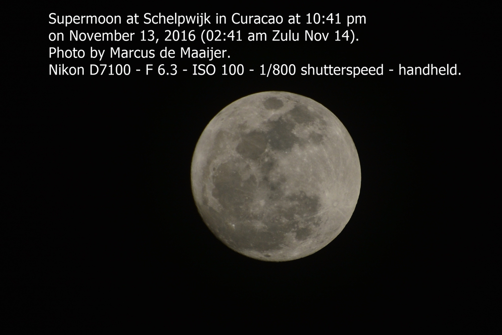
- supermoon
|
- By Marcus DeMaaijer <demaaijer at yahoo.com>
- Date: Mon, 14 Nov 2016 02:56:15 +0000 (UTC)
|
Curaçao (12°7'N 68°56'W)
November 13, 2016 ~ 10:41 pm (Nov 14 02:41 Hrs Zulu)
Good evening everyone in Curacao and elsewhere,
Look up in the sky! It's not a bird, it's not a plane, it's superrrrrrrmoooooon.
For photography tips app me or click on the image below to read how I photographed this unique event.
enjoy the view,
Marcus whatsapp: +599-9 6683500 Email: demaaijer at yahoo.com
Attachment:
MDM_2417supermoon.JPG
Description: JPEG image
|
|
- Update
|
- By Marcus DeMaaijer <demaaijer at yahoo.com>
- Date: Fri, 4 Nov 2016 22:24:16 +0000 (UTC)
|
Curaçao (12°7'N 68°56'W) Weather update November 04, 2016 ~ 6:15 pm (Nove 4 22:15 hrs Zulu)
Good evening everyone in Curacao and elsewhere,
There is a patch of bad weather heading from Venezuela into direction of Curacao and Bonaire. The eastern part of Curacao may experience most of the bad weather around 10pm and the rest of Curacao may experience iolated light showers during the night. Just 26 days till the end of storm season.
be safe,
Marcus whatsapp: +599-9 6683500 Email: demaaijer at yahoo.com
 | Security Check Required | | |
|
|
- lightning moved offshore
|
- By Marcus DeMaaijer <demaaijer at yahoo.com>
- Date: Fri, 4 Nov 2016 03:56:26 +0000 (UTC)
|
Curaçao (12°7'N 68°56'W) Weather update November 03, 2016 ~ 11:54 pm (November 04 03:54 hrs Zulu)
Good evening everyone in Curacao and elsewhere,
Lightning and scattered showers have moved offshore in Curacao. At first light in the morning, there is a 25% chance for scattered, light showers.
sweet dreams,
Marcus whatsapp: +599-9 6683500 Email: demaaijer at yahoo.com
|
|
- lightning and scattered rain
|
- By Marcus DeMaaijer <demaaijer at yahoo.com>
- Date: Fri, 4 Nov 2016 02:18:10 +0000 (UTC)
|
Curaçao (12°7'N 68°56'W) Weather update November 03, 2016 ~ 11:15 pm (Nove 4 03:15 hrs Zulu)
Good evening everyone in Curacao and elsewhere,
Lightning and scattered showers are now active in Curacao. Affected areas now are Sun valley, Sunset Heights, Brievengat, Schelpwijk, Jongbloed,
Piscadera, Sumbu, Veeris, Dein, Ascencion, and Williwood. One lightning strike was reported in area of Schelpwijk at 10:02 pm Curacao Local time.
be safe,
Marcus whatsapp: +599-9 6683500 Email: demaaijer at yahoo.com
|
|
- first wave of thunder, rain and lightning has passed, more still to come
|
- By Marcus DeMaaijer <demaaijer at yahoo.com>
- Date: Wed, 19 Oct 2016 04:13:57 +0000 (UTC)
|
Curaçao (12°7'N 68°56'W) Weather update Oct 19, 2016 ~ 00:09 am (Oct 19 04:09 hrs Zulu)
Hello everyone,
The first wave of rain, thunder and lightning from the tail of
the new invest, just now passed. More is on the way.
Curacao has not experienced this much thunder and lightning in a loooong time.
I took a few video's of the thunderstorm and I am right now placing them on the
CARE (Curacao Animal Rescue) facebook page with "public" setting (link below).
I hope that all dogs are still at home and not now wandering the streets.
Please make sure that your dogs are safe.
if they tend to flee the premises due to thunder, take them inside the house
or another adequate shelter for the next few hours till daylight.
There is more rain, thunder and lightning on the way in the tail of the new invest that is passing north of Curacao right now.
with sunny, green regards,
Marcus whatsapp: +599-9 6683500
|
|
- rain and thunder
|
- By Marcus DeMaaijer <demaaijer at yahoo.com>
- Date: Wed, 19 Oct 2016 02:37:08 +0000 (UTC)
|
Curaçao (12°7'N 68°56'W) Weather update Oct 18, 2016 ~ 10:35 pm (Oct 19 02:35 hrs Zulu)
Hello everyone,
Right now some much needed rain heading NNW from Venezuela to Curacao (and Aruba)
and it looks like on the radar that some lightning and thunder is tagging along...
Please make sure that your dogs are safe.
if they tend to flee the premises due to thunder, take them inside the house
or another adequate shelter for the next few hours.
see radar image in attachment.
with sunny, green regards,
Marcus whatsapp: +599-9 6683500
Attachment:
20161018-thunder.jpg
Description: JPEG image
|
|
- evening showers
|
- By Marcus DeMaaijer <demaaijer at yahoo.com>
- Date: Tue, 18 Oct 2016 03:03:50 +0000 (UTC)
|
Curaçao (12°7'N 68°56'W) Weather update Oct 17, 2016 ~ 11 pm (Oct 18 03 hrs Zulu)
Hello everyone,
Right now some much needed rain heading NNW from Venezuela to Curacao (and Aruba)
see radar image in attachment.
with sunny, green regards,
Marcus whatsapp: +599-9 6683500
Attachment:
20161017-rain from venezuela heading NNW.jpg
Description: JPEG image
|
|
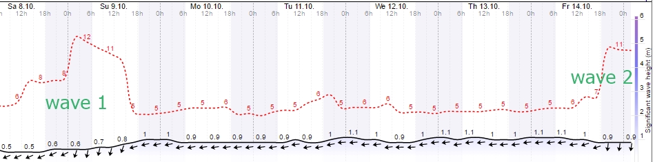
- Northern 10+ Swell Period Oct 9 & 14
|
- By Marcus DeMaaijer <demaaijer at yahoo.com>
- Date: Sat, 8 Oct 2016 04:59:32 +0000 (UTC)
|
Curaçao (12°7'N 68°56'W) Weather update Oct 8, 2016 ~ 00:57 am (Oct 8 04:57 hrs Zulu)
Good morning dushi Korsou,
10+ Swell Periods
Right now it looks like the 10+ swell periods will not arrive Saturday, but 24 hrs later on Sunday October 9th.
Then its choppy till the second batch of 10+ swell period waves arrive on Friday Oct. 14...
and possibly continues till Saturday evening.
Please see the attached 7-day forecast chart.
Today Saturday
morning will be a perfect day to enjoy the beaches between Santa Barbara and Kokomo with a soft breeze from SE.
In the afternoon the wind will pick up to cool things off before sunset.
Sunny skies all day.
Other news
The Ministry of Foreign Affairs of The Netherlands gave 750,000 Euro in humanitarian aid available to those affected by Hurricane Matthew in Haiti. The contribution will be used by the Red Cross for water, shelter and medical care.
sunny, green regards,
Marcus
Attachment:
northshore swells - plus ten wave period.jpg
Description: JPEG image
|
|
- Matthew in Florida, Georgia, South and North Carolina
|
- By Marcus DeMaaijer <demaaijer at yahoo.com>
- Date: Fri, 7 Oct 2016 08:14:22 +0000 (UTC)
|
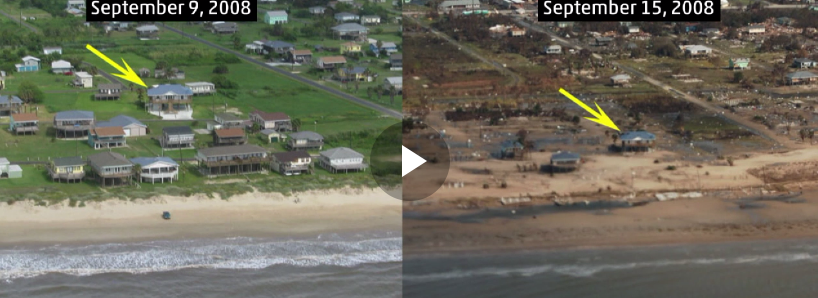
The presidential election in Haiti was postponed last Sunday Oct 2 due to Matthew. And now Haiti is mourning over 250 loss of human life. Currently On Oct 7, people along eastern coast of Florida are urged to evacuate due to life threatening storm surge up to 4 meters. But still many people want to stick it out. Matthew is not a little problem, please evacuate... Also evacuate the coastlines of Georgia, South Carolina and North Carolina. After hitting North Carolina Matthew could make a U turn then head south back into the Caribbean. Please look at the video link below what happened with hurricane Ike in 2008 when it made landfall in Texas (in attachment also a screenshot from the video). Storm surge and winds from the north western part of Matthew are life threatening. Please evacuate or prepare for the storm because first responder rescue teams may not get into your area along the eastern coast of 4 USA States for several days. I have family in all four, so I am concerned for their wellbeing and others.
Keep watching the several video on this link (skip adds in 2 secs)
| |  | Matthew Producing 70+ MPH Wind Gusts in East Florida; Potentially Catastrop... Matthew likely to be a devastating strike on Florida and Georgia. | | | |
Attachment:
capture-20161007-034555.png
Description: PNG image
|
|
- big waves hammering island
|
- By Robert Candelaria <robertcandelaria at rocketmail.com>
- Date: Tue, 4 Oct 2016 17:43:20 +0000 (UTC)
|
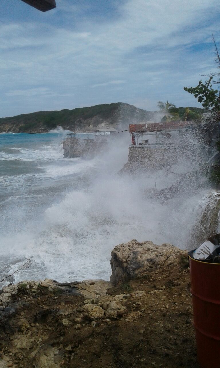
Hi folks, The southern part of our island i getting hammered with big waves. Everybody have to stay away from the seaside. There are a lot of damage at our beaches, especially Boca st. michiel and knipbay.
Attached some pics Attachment:
pic 1.jpg
Description: JPEG image
Attachment:
pic 2.jpg
Description: JPEG image
Attachment:
pic 3.jpg
Description: JPEG image
|
|
- Matthew weakening
|
- By Marcus DeMaaijer <demaaijer at yahoo.com>
- Date: Sat, 1 Oct 2016 11:43:08 +0000 (UTC)
|
Curaçao (12°7'N 68°56'W) Weather update October 1, 2016 ~ 07:00 am (11:00 hrs Zulu) Rain last minute :0mm Rain accumulation for today : 0mm Temperature : 27.9°C/82.2°F Humidity : 83.3% Wind Direction : East(84.82°) Wind Speed : 22 Km/h
Good morning,
Woke up to a beautiful red and orange color tinted sunrise with singing bananaquit and trupial birds as my waking music through the window in my bedroom.
There is still an overcast sky, but no rain.
Matthew is a weakened cat 4 now after having been a cat 5 hurricane last night.
For 24 hours straight Matthew has been dipping south in a westerly direction away from Curacao.
It may sound unbelievable but Curacao did not get hurricane force winds and also the rain was less than forecasted.
Some minimal beach erosion occurred along the southern coastline, but the damage was minimal to none in most locations.
The rocky cliffs along the northern shoreline served as a normal, natural barricade for ocean waves.
The northern shoreline is a favorite area for scuba diving, nature photography, watching waves crashing on rocky cliffs and surfing.
The latter was enjoyed by the local professional surfers during Matthew.
The beaches along the southern coastline will be open to the public again today.
After a Dutch pancake breakfast this morning I will head to the beach myself...
with sunny, green regards,
Marcus Whatsapp: +599-9 6683500
|
|
- Matt cat 5
|
- By Marcus DeMaaijer <demaaijer at yahoo.com>
- Date: Sat, 1 Oct 2016 06:05:24 +0000 (UTC)
|
I woke up to check up on Matt and can't believe he is cat 5 now....wow.
Curacao may have some material losses but we incurred no loss of life.
There is a monster churning just west of us, and we have no loss of life.
Thank God.
Curacao is still not in the clear (I really dislike writing this)
Onshore calm wind, starry skies and no rain.
Along southern shoreline, the coastal areas experience beach erosion.
with sunny, green regards,
Marcus Whatsapp: +599-9 6683500
|
|
- Matt is Cat 4
|
- By Marcus DeMaaijer <demaaijer at yahoo.com>
- Date: Fri, 30 Sep 2016 21:51:37 +0000 (UTC)
|
Curaçao (12°7'N 68°56'W) Weather update Sept 30, 2016 ~ 5:51 pm (Sept 30 9:51 hrs Zulu)Sea turbulence increased significantly so that local authorities closed several beaches. Wind and rain are minimal. I am looking forward to see patches of blue sky overhead soon.I'm not into skies with shades of grey.It is not over till the plump lady sings.
Matt is now a cat 4 hurricane, this is no joke peoples. The warm waters in the submerged Continental Plain between Colombia and Aruba is till providing energy to Matt. Curacao, Bonaire and Aruba are still not in the clear. Also keep an eye on the clockwise spinning system that is trying to rip off a piece from Matt and head in an opposite direction. with sunny, green regards,
Marcus Whatsapp: +599-9 6683500 CARE: https://www.facebook.com/Curacao.Animal.Rescue/
|
|
- congratulation
|
- By Robert Candelaria <robertcandelaria at rocketmail.com>
- Date: Fri, 30 Sep 2016 17:40:57 +0000 (UTC)
|
Hi folks Watching what marcus posted one hour ago, he was right. We are getting heavy rainshowers at the moment from the southwest. Congratulation my friend, job well done.
Will keep you posted
Robert |
|
- Curacao is NOT out of clear yet
|
- By Marcus DeMaaijer <demaaijer at yahoo.com>
- Date: Fri, 30 Sep 2016 16:08:51 +0000 (UTC)
|
Curaçao (12°7'N 68°56'W) Weather update
Sept 30, 2016 ~ 12:06 pm (Sept 30 16:06 hrs Zulu)
Time Lat Lon Wind(mph) Pressure Storm type
------------------------------------------------------------------------
15 GMT 09/28/16 13.4N 60.7W 60 1008 Tropical Storm
21 GMT 09/28/16 13.8N 62.0W 60 1008 Tropical Storm
03 GMT 09/29/16 13.9N 63.1W 65 1004 Tropical Storm
09 GMT 09/29/16 14.0N 64.7W 65 1002 Tropical Storm
15 GMT 09/29/16 14.2N 66.3W 70 996 Tropical Storm
21 GMT 09/29/16 14.1N 67.8W 75 993 Category 1 Hurricane
03 GMT 09/30/16 14.1N 68.8W 80 983 Category 1 Hurricane
06 GMT 09/30/16 14.1N 69.3W 100 979 Category 2 Hurricane
09 GMT 09/30/16 14.0N 69.9W 100 979 Category 2 Hurricane
15 GMT 09/30/16 13.7N 70.8W 115 968 Category 3 Hurricane
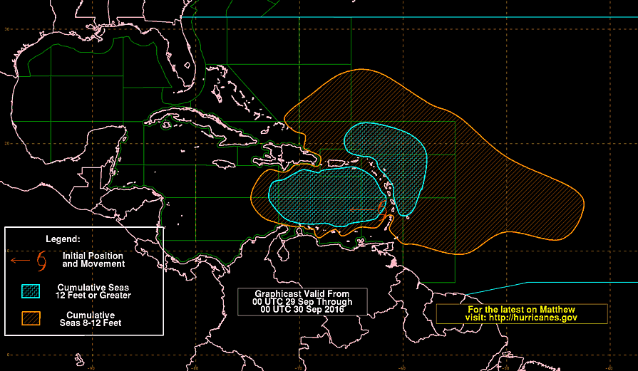
Matthew is dipping south again and is heading straight for shallow, warmer waters of the submerged Continental Plain between Venezuela and Aruba, as I forecasted last night.
And Matthew gathered the energy in these warmer shallow waters to become a Cat 3 hurricane.
Please see attachments for other things now of concern to monitor closely.
Possible heavy rainshowers are on their way to Curacao right now from Southwest heading Northeast.
Please be safe and stay tuned to the weather news updates on radio and on internet, Curacao is not in the clear yet. with sunny, green regards,
Marcus whatsapp: +599-9 6683500 Telephone: +599-9 7898887 Email: demaaijer at yahoo.com
Attachment:
images2.jpg
Description: JPEG image
Attachment:
201609300208_at_graphicast.png
Description: PNG image
Attachment:
rain.png
Description: PNG image
|
|
- Curacao not yet in the clear
|
- By Marcus DeMaaijer <demaaijer at yahoo.com>
- Date: Fri, 30 Sep 2016 15:12:56 +0000 (UTC)
|
Curaçao (12°7'N 68°56'W) Weather update Sept 30, 2016 ~ 11:06 am (Sept 30 15:06 hrs Zulu)
Morning everyone,
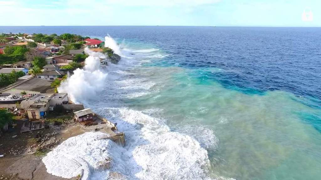
Everyone in Curacao exclaimed a sigh of relief. The previously forecasted heavy rain downpour, SW winds, and severe flooding of low level areas along southern coastline we escaped. The local surfers had the time of their life on the 30 ft waves along the northern coastline. I can not publish those surfing pictures here but you can enjoy them on my FB timeline at www.facebook.com/marcus.de.maaijer
please keep monitoring Matthew that now is a cat 2 hurricane, even when it passed far SW of Curacao, because when it starts its steep move northwards later afternoon/tonight on Friday or Saturday morning, it could make a move to east then go north. In case this happens, even the slightest eastwards direction, the southern coastline will receive huge waves like we are experiencing right now at the northern coastline. Similar waves we experienced during Lenny (1999) and Omar (2008). So let's keep our fingers crossed. The reason we escaped the rain and wind today is because probably yesterday Matthew was a cat 1.6 hurricane and overnight it became cat 2 so that it became a stronger, better organized and much more compacter storm without long outer bands full of rain that is commonly associated with with weak systems such as a depression or cat 1 storm. At Playa Canoa, Boca Pistol, Boca Ufo, Boca Asencion, Boca Saint Joris, and Tera Cora on the northern coastline yesterday night, the LOCAL PROFESSIONAL surfers experienced much larger swells than a Cat 1 hurricane would normally produce, so we estimated that Matthew must have been Cat 1.6 at the time and strengthened then further.
But before you all exclaim and breathe a sigh of relief, Curacao is not out of the clear yet. There are rip currents along the coast and there are choppy waves at the beaches, and we can still experience some skywater. So be safe, enjoy your day off, and keep tuned to your favorite local weather blogs.
Furthermore I wish to ask local nonexperienced surfers to avoid entering the seas at the northern coastline to prevent loss of life. Some locations have a surf clinic or professional surfer present who you should consult prior to entering the water. Never attempt to enter the water without professional surfers knowing what you are doing. We surfers love our 20 to 30 ft surfing opportunities that seasonal storms bring, but please be careful, because this is a dangerous sport.
ps: if you can spare a few bucks, please check out the main page of http://www.stormcarib.com/ about how you can donate. Stormcarib is noncommercial and we rely on donations to keep you safe and informed during the 2016 hurricane season and beyond.
with sunny, green regards,
Marcus
whatsapp: +599-9 6683500
Telephone: +599-9 7898887
Email: demaaijer at yahoo.com
CARE Comite: https://www.facebook.com/Curacao.Animal.Rescue/
|
|
- cold and dry tonight
|
- By Marcus DeMaaijer <demaaijer at yahoo.com>
- Date: Fri, 30 Sep 2016 01:56:07 +0000 (UTC)
|
Curaçao (12°7'N 68°56'W) Weather update Sept 29, 2016 ~ 09:30 pm (Sept 30 1:30 hrs Zulu)
Good evening,
Right now it is a chilly night for Curacao standards with temp of 25.4°C/77.7°F at my house. I just got back from driving around, but there are just a few sprinkles here and there and no significant rain downpour. So far today rain accumulation is 37.8mm. There is a reverse current at the southern coastline and choppy waves at the northern coastline. Wind is blowing with a soft breeze from the south west with speed 0.4Knots/0.5Km/h. Humidity is 91%. Most Chinese supermarkets/general stores and some restaurants will remain open till 11pm, so that people can still stock up before Matthew reaches us.
This morning on Sept 29 all schools commenced normal at 715 am but after the first heavy downpour a few directors of local schools informed parents to come pick up their children at 930am, but most schools remained open. Then at 3pm the organisation in charge of the general elections held a press conference and announced to the general elections of Curacao on Sept. 30 were cancelled and a new date will be announced next week or later. The VPCO announced that their schools will be closed on Friday. Several businesses at and near the southern coastline took precautionary measures.
Matthew headed south west at 21:00 hrs zulu (5pm local time), so that made me a wee bit nervous. The continental plane, where Aruba is located, has shallow warmer waters than the deep colder waters around Bonaire and Curacao and the storm seems to be heading into that direction. After absorbing the energy of the warmer waters near Aruba the storm may start a steep climb to northern direction Friday night or Saturday morning.
Time             Lat   Lon   Wind(mph)  Pressure  Storm type
------------------------------------------------------------------------
15 GMT 09/28/16  13.4N 60.7W     60       1008     Tropical Storm
21 GMT 09/28/16  13.8N 62.0W     60       1008     Tropical Storm
03 GMT 09/29/16  13.9N 63.1W     65       1004     Tropical Storm
09 GMT 09/29/16  14.0N 64.7W     65       1002     Tropical Storm
15 GMT 09/29/16  14.2N 66.3W     70        996     Tropical Storm
21 GMT 09/29/16  14.1N 67.8W     75        993     Category 1 Hurricane

I'm going to get some zzzz's now so I may be fresh and ready to assist people/animals in emergency situations when Matthew's rains, waves or other arrive.
with sunny, green regards, Marcus Whatsapp: +599-9 6683500
| | Security Check Required | | |
|
|
- rain at the time
|
- By Robert Candelaria <robertcandelaria at rocketmail.com>
- Date: Thu, 29 Sep 2016 13:04:18 +0000 (UTC)
|
A blessed morning folks, We woke up this morning with lot of rain and thunder in the background. No lightning yet. Rain that we were waiting on for long. Waiting now for tropical storm Matthew to pass as a hurricane north of our island on Friday at around 2 AM. Hope we will get only some rain and no strong winds to cause destruction. Let's pray for the best.
Will keep you posted.
God keep us safe,
Robert.
|
|
- 90% overcast sky plus rain
|
- By Marcus DeMaaijer <demaaijer at yahoo.com>
- Date: Thu, 29 Sep 2016 11:18:40 +0000 (UTC)
|
Curaçao (12°7′N 68°56′W)
Weather update Sept 29, 2016 ~ 7 am (11:00 hrs Zulu)Good morning,
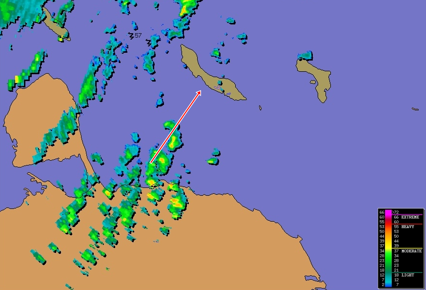
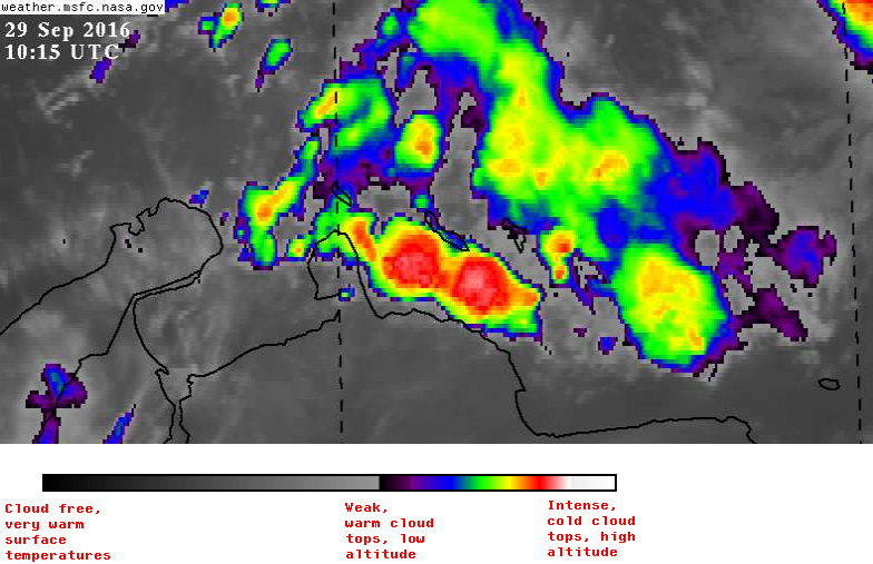
Currently Curacao has 90% overcast skies plus moderate to heavy isolated rain showers. Thunder can be heard all over. So far no lightning strikes have been reported.
Stay safe, please be careful all day and night during traffic on Thursday and Friday, use headlights day and night so others can see you, and drive slow while wearing seatbelts.
On thursday after 7pm through Saturday afternoon I will be on the road to pull free any motorized vehicles who get stuck in drainage ditches or mud, and apply first aid as needed. You can app me if in the areas of salinja, zeelandia, jongbloed, biesheuvel, damacor, mahaai, zuikertuintje, groot davelaar, cas cora, schelpwijk, toni koentjie, and cerrito. PS: i AM DOING THIS ON VOLUNTARY BASIS. with sunny, green regards, MarcusWhatsapp: +599-9 6683500 CARE: https://www.facebook.com/Curacao.Animal.Rescue/
Attachment:
capture-20160929-070603.png
Description: PNG image
Attachment:
graphicast.png
Description: PNG image
|
|
- hot night with clear starry skies
|
- By Marcus DeMaaijer <demaaijer at yahoo.com>
- Date: Thu, 29 Sep 2016 04:09:11 +0000 (UTC)
|
Curaçao (12°7′N 68°56′W)
Weather update
Sept 28, 2016 ~ 11:50 pm (Sept 29 3:50 hrs Zulu)
Good evening,
Right now it is a sweltering hot night with no clouds, clear starry skies and hardly no wind.
Matthew is now at 13.9 N 63.1 W and its outer bands with heavy rains are possibly over Curacao during the night time morning hours of Thursday Sept 29. Matthew has slammed on the brakes and is currently moving W at a crawling pace of 22.5 km/h.
On Thursday Sept 29, schools will remain open until the minister of education or the schools individually decide otherwise.
Schools will be closed on Friday Sept 30 as planned months ago, because Curacao will have general elections on Friday and the schools will be used to cast votes.
Stay safe, please be careful during morning traffic on Thursday, use headlights so others can see you, and drive slow while wearing seatbelts.
On thursday after 7pm through Saturday afternoon I will be on the road to pull free any motorized vehicles who get stuck in drainage ditches or mud, and apply first aid as needed. You can app me if in the areas of salinja, zeelandia, jongbloed, biesheuvel, damacor, mahaai, zuikertuintje, groot davelaar, cas cora, schelpwijk, toni koentjie, and cerrito.
with sunny, green regards,
Marcus
Whatsapp: +599-9 6683500
CARE: https://www.facebook.com/Curacao.Animal.Rescue/
|
|
- Matthew
|
- By demaaijer <demaaijer at yahoo.com>
- Date: Wed, 28 Sep 2016 13:49:38 -0400
|
|
Curaçao (12°7′N 68°56′W)
Weather update
Sept 28, 2016 ~ 01:45 pm (17:45 hrs Zulu)
Good afternoon,


This morning Sept 28, the hurricane hunters flew into invest 97L and discovered a closed center of circulation. Invest 97L is now Tropical Storm Matthew. Currently Matthew is approx located at 13.4N 60.7W and it is forecasted to drop slightly WSW. The models predict heavy rainfall, and lightning, so all those who were inundated or had damage during lightning strikes during Tomas, should take precautionary measures to prevent loss of property again.

Right now Curacao has sunny skies and a much cooler temperature than Tuesday. But after midnight, during early morning on Thursday Sept 29 the rains are predicted to come down.

Stay safe, please be careful during morning traffic on Thursday, use headlights so others can see you, and drive slow.
with sunny, green regards,
Marcus
Mobile/whatsapp: +599-9 6683500
CARE Comite: https://www.facebook.com/Curacao.Animal.Rescue/
Verzonden vanaf Samsung Mobile. |
|
- Waiting
|
- By Robert Candelaria <robertcandelaria at rocketmail.com>
- Date: Wed, 28 Sep 2016 13:15:42 +0000 (UTC)
|
Hi, folks Strong Tropical wave still moving west to west north-west. We are following the track and preparing to get some rain, wind, thunder and lightning Good luck for those in the east and stay safe.
Robert |
|
- Invest 97L weakening?
|
- By Marcus DeMaaijer <demaaijer at yahoo.com>
- Date: Wed, 28 Sep 2016 05:32:01 +0000 (UTC)
|
Curaçao (12°7′N 68°56′W)
Weather update
Sept 28, 2016 ~ 01:00 am (05:00 hrs Zulu)
For those not in ZzzZz land now, good morning.
On Tuesday Sept 27, the hurricane hunters flew into invest 97L and were unable to locate a center of circulation. Currently 97L is approx located a 13.1N 55.3W. After comparing weather models of today and the ones of 24 hours earlier, it appears that 97L is weakening. This could be the result of the system's close proximity to the South American continent. Hopefully the hurricane hunters can verify this later today in the morning when they will fly into 97L for a second time to take measurements. If again they are unable to locate a center of rotation, that is good news for Curaçao. Regardless whatever the outcome may be, Curacao will get some much needed rain. Although Curaçao is not looking forward to a repeat of Tomas in 2010 which produced more rain than we could handle. The models do predict heavy rainfall, so all those who were inundated during Tomas should take precautionary measures to prevent loss of property again. Just in case..
If the rains are far less than Tomas, count it as a blessing and another lesson learned in life.
Today the forecast is calling for sunny skies and a much cooler temperature than Tuesday.
Finally I wish to share with you one of my favorite bible verses:
Matthew 18:20 "For where two or three come together in my name, there am I with them." with sunny, green regards,
Marcus
Mobile/whatsapp: +599-9 6683500
CARE Comite: https://www.facebook.com/Curacao.Animal.Rescue/
|
|
- 5 day weather forecast Curacao
|
- By Marcus DeMaaijer <demaaijer at yahoo.com>
- Date: Tue, 27 Sep 2016 00:15:02 +0000 (UTC)
|
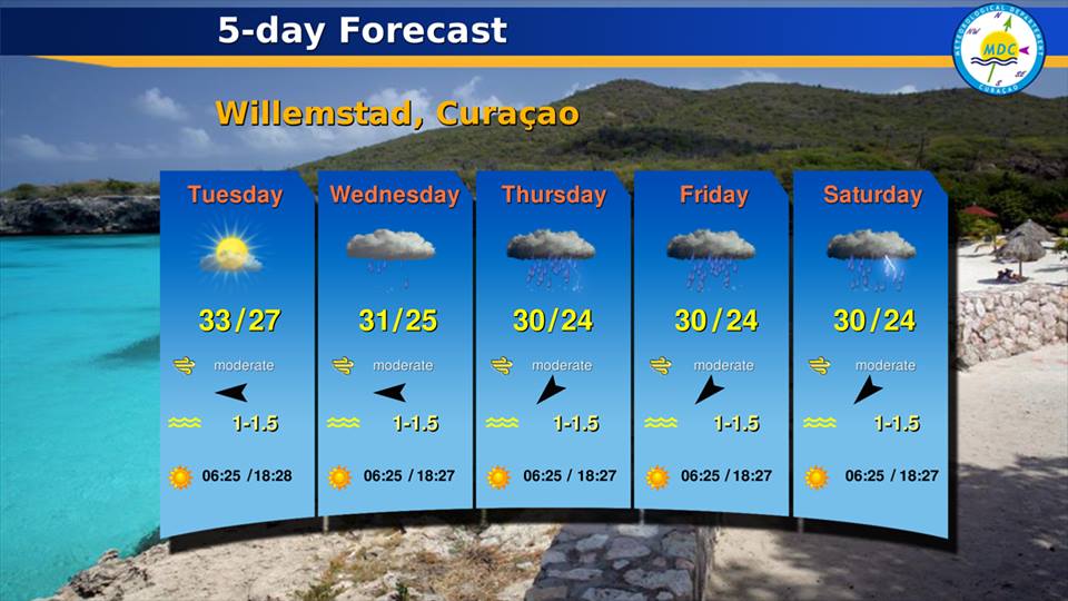
Today at 4pm the Meteorological Department Curacao issued this 5 day weather forecast in attachment
with sunny, green regards,
Marcus
Mobile/whatsapp: +599-9 6683500
Email: demaaijer at yahoo.com
CARE Comite: https://www.facebook.com/Curacao.Animal.Rescue/
Attachment:
Meteorological Department Curacao.jpg
Description: JPEG image
|
|
- Invest 97L
|
- By Marcus DeMaaijer <demaaijer at yahoo.com>
- Date: Mon, 26 Sep 2016 03:31:31 +0000 (UTC)
|
Currently waiting for more weather data in regards to Invest 97L. I've been watching this weather oddity since the moment it popped up on the forecasting models on September 20. It is currently too low, too close to the equator, to start spinning rapidly around an axis. On approx Sept 27 I will hold my breath and wait to see what invest 97L will be doing. On that date 97L will be far enough from the equator when it hits latitude of approx. 13 degrees North. Will it start spinning faster, start strengthening or die? I am praying for the latter.
It is not really certain what will happen as of yet, but it is advised to prepare ahead of time. If you haven't bought extra food supplies for your pets, other animals and your family yet, this is a good time to do so starting Monday Sept 26. Make sure you have enough to last at least 7 to 10 days. Especially food that does not need to be cooled. Also stock up on fresh water that will last at least 7 to 10 days for drinking for the pets and you and your family, especially since pets don't drink bottled juice or soft drinks. You will also need water for cooking, flushing toilets, bathing and doing laundry. You can possibly collect rain to flush the toilets and do laundry, and then you save fresh water for the rest mentioned. Also don't forget to stock up on medicine for chronic illnesses such as diabetes and/or other.
with sunny, green regards,
Marcus
Mobile/whatsapp: +599-9 6683500
Email: demaaijer at yahoo.com
CARE: https://www.facebook.com/Curacao.Animal.Rescue/
|
|
- hello all
|
- By Marcus DeMaaijer <demaaijer at yahoo.com>
- Date: Sun, 25 Sep 2016 02:43:16 +0000 (UTC)
|
This is just a notification that I am back :)
There is nothing significant to report yet...
I am eager to see what the data will show east of me on approx. Tuesday Sept 27. with sunny, green regards,
Marcus
Whatsapp: +599-9 6683500
CARE Comite: https://www.facebook.com/Curacao.Animal.Rescue/
Please Help To Save Paper, Trees and the Oxygen Producing Oceans & Seas.
Instead of printing, store this email digitally in the cloud, or on a hard -or flashdrive. |
|
