|
|
- - - 2015 Hurricane Season - - -
|
- ANTiGUA RAIN!!
|
- By Martha Watkins Gilkes <marthawatkinsgilkes at gmail.com>
- Date: Thu, 21 Apr 2016 09:55:29 -0400
|
IT HAS  BEEN POURING WITH  BEAUTIFUL RAIN  OFF AND ON THE LAST   2  days… so
places much heavier than others..  We are  thankful for htis  given our
drought we have been suffering.
|
|
- THINKING OF ALL IN THE BAHAMAS
|
- By Martha Gilkes <marthawatkinsgilkes at gmail.com>
- Date: Fri, 2 Oct 2015 07:16:38 -0400
|
Thinking of all in the BAHAMAS in harms way with this devastating hurricane .. NOT JUST on land but the SEA CREATURES and especially a special pod of SPOTTED DOLPHINS i had the pleasure of spending time with in June via THE the Wile Dolphin Project http://www.wilddolphinproject.org. These dolphins have been studied for over 30 years .. I hope they can survive in deeper water but they must surface to breath.. PHOTO OF Martha snorkeling with mother and baby spotted dolphin by TANYA BURKETT.  |
|
|
- INSPIRING WORDS FROM GERT THE CREATOR OF THIS STORM CARIB
|
- By Martha Gilkes <marthawatkinsgilkes at gmail.com>
- Date: Sun, 6 Sep 2015 13:15:15 -0400
|
THIS ( BELOW) SUMS UP HOW STORM CARIB WAS FORMED.. Although it is ON GERTS HOME PAGE I am reposting as some dont read the home page.... I ( AND A FEW OTHERS) HAVE been reporting on this site since it started.. it is an invaluable service for people who live away to keep in touch with their families and what is going on.. I have a number of stories i will someday share of the connections I have made here... With great RESPECT TO GERT for "staying the mile" in keeping this site going in spite of personal expenses... ( and while he wont always ASK.. a donation no matter how small - is appreciated... see the link on his home page... and here we go again with WATCHING GRACE DANCING OUT THERE... which island/ islands will she "grace us with her prescence" ? Antigua NEEDS RAIN SO LETS HOPE she is a water woman!!
Saturday, September 5, 2015 09:43AM PDT - Luis - Twenty Years AgoToday marks the 20th anniversary of Hurricane Luis, a massive category 5 storm with a 45 miles diameter eye. This was my introduction to not only the destructive forces of a hurricane itself, but also how stressful and complicated the aftermath is. My in-laws were living on St.Maarten at that time. When we saw them that Christmas, months after the storm, we were shocked what the stress of the hurricane had done to them. This storm was also the inspiration for this website. We were travelling through Greece and Israel for my studies when the hurricane hit and could not get in contact with our family. Newspaper reports were minimal and not helpful, like: "St.Maarten was hit by a hurricane. We are unsure of how many people survived.", adding to the stress. The internet was not like it is now, it was very hard to get 'real' non-sensational non-generalized information on what was going on on the islands. It is very stressful for people 'outside' to not know what is going on. This website has hopefully helped many people put their mind a bit at ease, by reading what the local hurricane correspondents report, and by communicating with each other through the Pleas for Help board. Hopefully it will be a long time before we have a bad storm like this! -Gert
|
|
|
- HERE WE GO AGAIN ???? GRACE
|
- By Martha Gilkes <marthawatkinsgilkes at gmail.com>
- Date: Sun, 6 Sep 2015 12:33:19 -0400
|
| THIS WILL PROBABLY CHANGE LOTS OVER THE NEXT DAYS BUT IT SAYS WE HAVE TO BE ALERT AND READY AS WE MAY HAVE ANOTHER SYSTEM ON TOP OF US IN ABOUT ONE WEEK GIVE OR TAKE... |
|
|
- THINKING BACK
|
- By Martha Gilkes <marthawatkinsgilkes at gmail.com>
- Date: Sat, 5 Sep 2015 07:34:14 -0400
|
It’s September 5, the 20thanniversary of Hurricane Luis; the most destructive and costly hurricane in Antigua and Barbuda’s history. It was our Katrina. WE WILL ALWAYS REMEMBER! |
|
|
- ERIKA GONE
|
- By Martha Gilkes <marthawatkinsgilkes at gmail.com>
- Date: Thu, 27 Aug 2015 19:10:18 -0400
|
| THE EVENING IS BACK OUR QUIET CARIBBEAN TYPICAL NIGHT WITH THE TREE FROGS FAMILIAR CHIRP .. ( although I do not have electricity and am operating on a generator...) . and we are so thankful we have been spared from serious damage but our hearts go out to our sister island to our south DOMINICA for the unexpected tragic loss of life and damage they have suffered. This was so unexpected and teachers us a BIG LESSON that YOU NEVER KNOW what "MOTHER NATURE" will do and it is always better to err on the side of caution and "over prepare".
The hurricane season is NOT OVER YET so we still have to be on guard!
|
|
|
- HUGE STORM
|
- By Martha Gilkes <marthawatkinsgilkes at gmail.com>
- Date: Thu, 27 Aug 2015 12:56:14 -0400
|
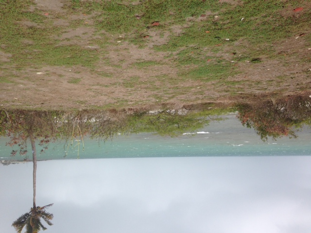
ERIKA STRETCHES THRU MANY OF THE ISLANDS we are Half Moon are still gettin big blow - not wind that is breaking up the house but trashing the garden! POWER HAS BEEN off and on and also internet. We are not in the all clear yet expecially here on the south coast. 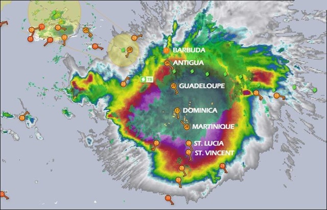
11949380_10152996775895308_3972867064747341743_n
|
|
|
- Breeze
|
- By Johnefuller <johnefuller at gmail.com>
- Date: Thu, 27 Aug 2015 10:23:32 -0400
|
Attachment:
IMG_1994.MOV
Description: QuickTime movie
Sent from my iPhone
|
|
- Erika
|
- By Johnefuller <johnefuller at gmail.com>
- Date: Thu, 27 Aug 2015 09:25:20 -0400
|
Sent from my iPhone
|
|
- Passing of Erika
|
- By Ronn D <ninklennor at gmail.com>
- Date: Thu, 27 Aug 2015 07:20:23 -0400
|
|
This morning things are still pretty calm though overclouded on the north of the island. The wind is prevalent but not overly strong. Conditions look similar but with small showers as i look to the south. Even now one is moving across the area.
Attachment:
IMG_20150827_071548.jpg
Description: JPEG image
Attachment:
IMG_20150827_071521.jpg
Description: JPEG image
|
|
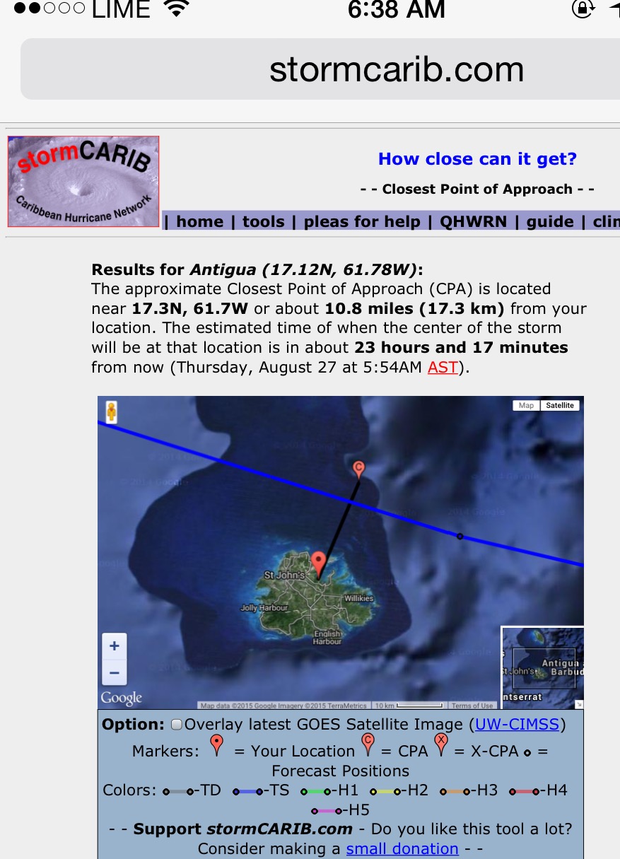
- STORM ERIKA AT THIS LOCATION VERY SOON
|
- By Martha Gilkes <marthawatkinsgilkes at gmail.com>
- Date: Thu, 27 Aug 2015 05:58:04 -0400
|
Screen Shot 2015-08-27 at 5.53.40 AM
|
|
|
- Gusty but little rain
|
- By Alan Scholl <scholla at candw.ag>
- Date: Thu, 27 Aug 2015 05:29:25 -0400
|
ERIKA's track is slightly more South, she is 30 miles SE of Antigua. Winds are
around 20-25mph with slightly higher gusts, for the last few hours we have had
little rain if any.

Alan Scholl
|
|
- OVER ANTIGUA NOW
|
- By Martha Gilkes <marthawatkinsgilkes at gmail.com>
- Date: Thu, 27 Aug 2015 05:24:34 -0400
|
|
|
|
- STORM ERIKA over ANTIGHA
|
- By Martha Gilkes <marthawatkinsgilkes at gmail.com>
- Date: Thu, 27 Aug 2015 05:21:53 -0400
|
..Early morning hello… ABS TV storm review which seems to have been on all night has just confirmed that at 2 .am. the storm was 70 miles from us and has slowed down.. it is very gusty at Half moon bay.. Will be checking the stats now.. Am thankful for every effort I have made to board up hearing that wind whipping…also electricity has gone off here from 4 a.m. Hope everyone safe and hope WE GET MORE RAIN! Our Hon Samatha Marshall has just stated publically that people should STAY HOME and NOT report to work. Wind has INCREASED to 50 MPH and will be around to late afternoon. More later...
|
|
|
- 8 pm advisory out.. still confused !
|
- By Martha Gilkes <marthawatkinsgilkes at gmail.com>
- Date: Wed, 26 Aug 2015 20:18:56 -0400
|
We are still on Storm warning.. and our airport was officially closed at 730 p.m. ... but seems EIRKA is not the strong woman we thought thank goodness .. ( but we do wish she would dump her showers of blessing on us! AND MAYBE SHE WILL LATER..
FROM WHAT i have been told in my limited "weather knowledge" the NHC cant go back and forth from taking on and off TSW to say it is on now and off tomorrow..and there are models that show her gaining strength agin as she moves north .. GOSH FLORIDA must be on a big hype - watched a report on this and as always the TV hypes it up ( good for ads! ??) ( although speaking to some Florida friends it is the "new snow birds " on hype and the old timers say .. " it will only be a CAT ONE"... But we can NEVER take weather with a "grain of salt"... UNLESS THERE IS ANYTHING MAJOR TO REPORT DURING THE NIGHT THIS IS MY LAST POST UNTIL "AFTER THE BLOW"... BE SAFE MY ANTIGUA BUDDIES AND THANKS TO THOSE ABROAD WHO CARE AND ARE FOLLOWING US.. AS my wise southern mama always said "THIS TOO SHALL PASS"...
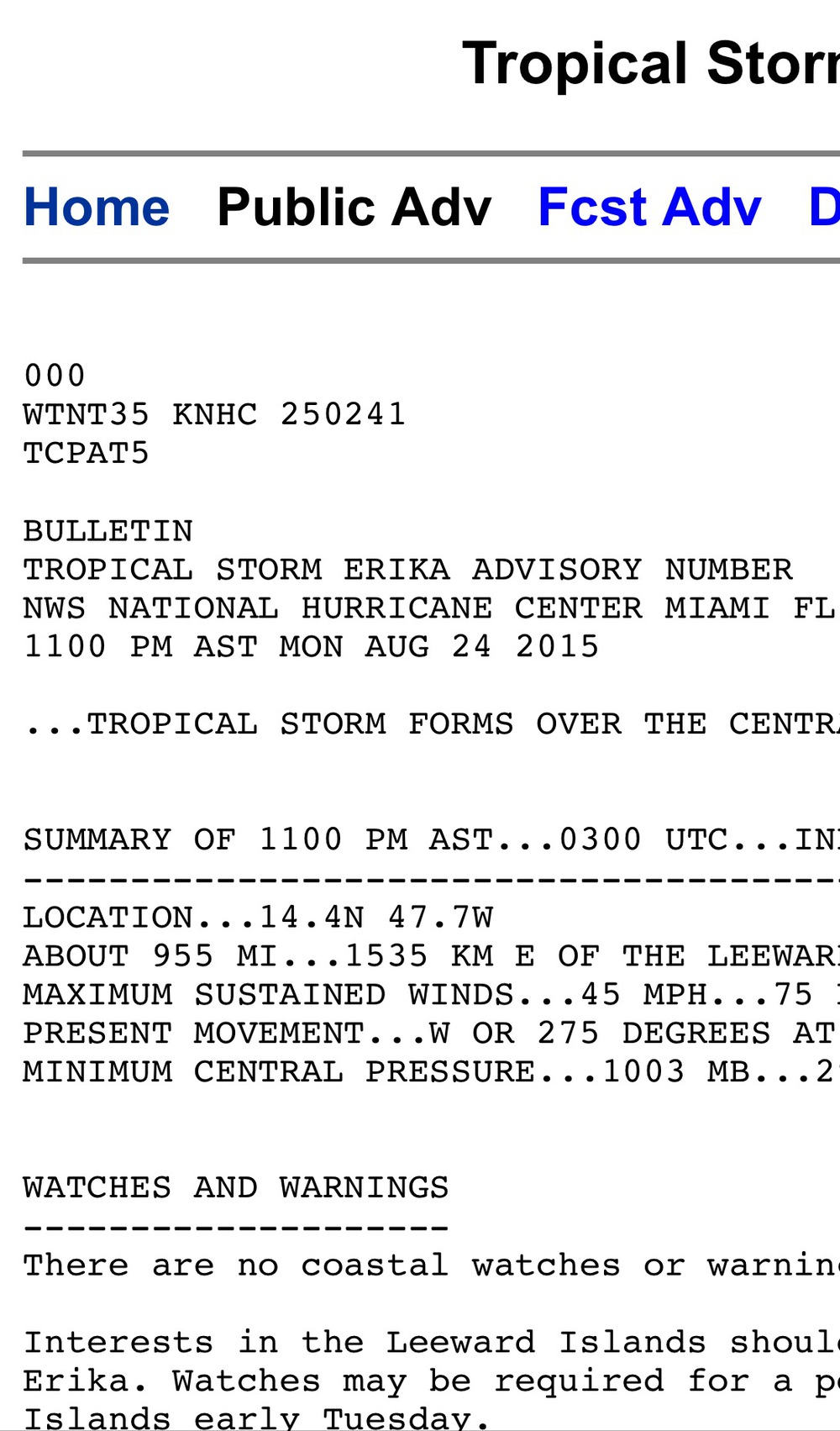
BULLETIN
TROPICAL STORM ERIKA INTERMEDIATE ADVISORY NUMBER   8A
NWS NATIONAL HURRICANE CENTER MIAMI FL       AL052015
800 PM AST WED AUG 26 2015

...POORLY ORGANIZED ERIKA EXPECTED TO MOVE THROUGH THE LEEWARD
ISLANDS OVERNIGHT...


SUMMARY OF 800 PM AST...0000 UTC...INFORMATION
----------------------------------------------
LOCATION...16.7N 59.5W
ABOUT 155 MI...250 KM E OF ANTIGUA
MAXIMUM SUSTAINED WINDS...45 MPH...75 KM/H
PRESENT MOVEMENT...W OR 280 DEGREES AT 17 MPH...28 KM/H
MINIMUM CENTRAL PRESSURE...1006 MB...29.71 INCHES
|
|
|
- 5 PM ERIKA REPORT
|
- By Martha Gilkes <marthawatkinsgilkes at gmail.com>
- Date: Wed, 26 Aug 2015 17:10:57 -0400
|
| MUCH CONFUSION ON ERIKA.... ( guess that is what WEATHER IS ?) SEEMS THE HURRICANE HUNTERS DID NOT FIND STORM FORCE WINDS ON LAST INVEST... BUT THE NHC STILL HOLDING ON TO IT BEING A TROPICAL STORM AND WE ARE STILL ON A STORM WARNING! Am told our AIRPORT CLOSES at 730 p.m. ( looking for an official statement on this now)... Sure is hard to know what is really coming at us... not that I am complaining at all - but hope it is SOME RAIN! .... and even though i have done several days of "preparedness" I dont mind as it was a good "drill"... My hurricane shutters - not used for 2 years now.. had lots of corrosion on them so it was a good thing to clean them up !! PLUS did some upgrades on some bolts on doors etc ... so this was not a bad "drill".
Guess we will soon know if we are getting anything at it is only 195 miles due east!
|
|
|
- 5 PM ERIKA REPORT
|
- By Martha Gilkes <marthawatkinsgilkes at gmail.com>
- Date: Wed, 26 Aug 2015 17:10:45 -0400
|
| MUCH CONFUSION ON ERIKA.... ( guess that is what WEATHER IS ?) SEEMS THE HURRICANE HUNTERS DID NOT FIND STORM FORCE WINDS ON LAST INVEST... BUT THE NHC STILL HOLDING ON TO IT BEING A TROPICAL STORM AND WE ARE STILL ON A STORM WARNING! Am told our AIRPORT CLOSES at 730 p.m. ( looking for an official statement on this now)... Sure is hard to know what is really coming at us... not that I am complaining at all - but hope it is SOME RAIN! .... and even though i have done several days of "preparedness" I dont mind as it was a good "drill"... My hurricane shutters - not used for 2 years now.. had lots of corrosion on them so it was a good thing to clean them up !! PLUS did some upgrades on some bolts on doors etc ... so this was not a bad "drill".
Guess we will soon know if we are getting anything at it is only 195 miles due east!
|
|
|
- COMING AT ANTIGUA NOW
|
- By Martha Gilkes <marthawatkinsgilkes at gmail.com>
- Date: Wed, 26 Aug 2015 15:56:33 -0400
|
|
|
|
- Ended up being a nice day for boating, but what happens next?
|
- By eli fuller <eliantigua at gmail.com>
- Date: Wed, 26 Aug 2015 14:22:57 -0400
|
|
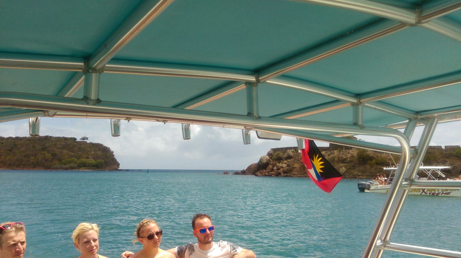
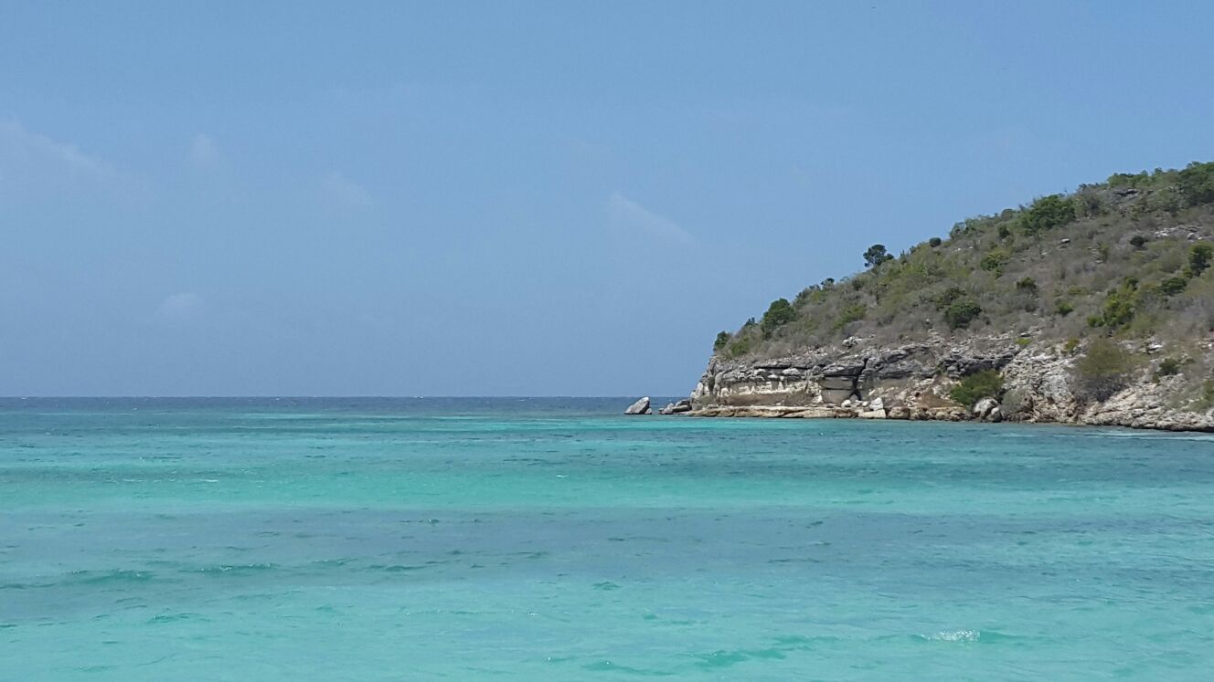
Our three power boats are out there today reporting nice conditions for snorkeling and sight seeing, but we've canceled tours for tomorrow expecting some action. However the latest loop shows her doing the same thing Danny did when it got close and things don't nearly as impressive as this am. We are ask desperate for rain here in drought torn Antigua. Hope windguru is right about the rainfall. We will see. Photos attached from today.
+1 268 725 7263
www.adventureantigua.com
www.twitter.com/antigua
www.instagram.com/p/dk-lKURFXI/
Attachment:
IMG-20150826-WA0031.jpg
Description: JPEG image
Attachment:
IMG-20150826-WA0021.jpg
Description: JPEG image
Attachment:
IMG-20150826-WA0028.jpg
Description: JPEG image
|
|
- 11 AM UPDATE OF STORM ERIKA
|
- By Martha Gilkes <marthawatkinsgilkes at gmail.com>
- Date: Wed, 26 Aug 2015 12:06:51 -0400
|
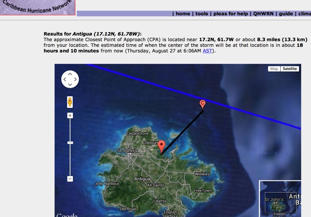
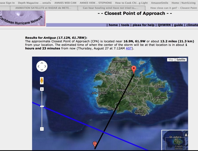
THE 11 A.M. ADVISORY IS IN SINCE THE 8 A.M ADVISORY STORM ERIKA HAS MOVED CLOSER TO US.. THE PROJECTED CLOSEST POINT IS ONLY 8.3 MILES FROM OUR AIRPORT. NOW 285 MILES AWAY AND MOVING AT THE SAME 17 MPH WHICH PUTS HER 16 HOURS AWAY ( THE CENTER..) BUT WE WILL GET THE OUTTER WINDS LONG BEFORE.. THAT STILL MAKES HER ARRIVING ( THE CENTER ) AROUND 3 A.M. I DO NOT LIKE NIGHT TIME STORMS! but guess i don't have a say in this.
I HAVE A FEW MORE THINGS TO "SECURE" SO SIGNING OFF FOR NOW... THANKS FOR ALL WHO HAVE SENT US MESSAGES OF LOVE AND CONCERN.
|
|
|
- STORM ERIKA WHen will we start to feel her effects
|
- By Martha Gilkes <marthawatkinsgilkes at gmail.com>
- Date: Wed, 26 Aug 2015 09:26:09 -0400
|
AS OF 8 a.m. STORM ERIKA is now 335 miles to the East of Antigua moving 280 degrees which is ONLY 10 degress right of west - almost direct at Antigua ( this puts the center 10 miles north of the airport )
Her forward speed has decreased from originally 20 mph to 18 mph and now to 17 MPH ( as was forecast) and with her slowing down the winds can increase. As of the 8 a.m. advisory - the latest one - the winds are back up to 45 MPH with higher gusts - our Met office suggest gusts of 60 MPH .. Still NOT A HURRICANE thank goodness... but that can do some tree branch damage or other more minor damage. ( and as i learned in Storm Danny other "things " can happen like a lightening strike next to my house that hit an electricity pole which caught on fire and cut my power!)
ON the course ERIKA now is ( AND remember that can change) that would put the COC ( center of circulation) near Antigua in 19 hours ( from 8 a.m) or 3 a.m this morning. However, because this is such a large system we will start feeling the wind and rain effects hours before ... Later this afternoon- today Wednesday - most likely. ANTIGUA DESPERATELY NEEDS THE RAIN so we are thankful for this ... but there is warning of flooding in low lying areas. We are very lucky we are NOT looking at a HURRICANE but still need to take care and take this storm seriously.
|
|
|
- A GOOD POINT ON THE COMING STORM
|
- By Martha Gilkes <marthawatkinsgilkes at gmail.com>
- Date: Wed, 26 Aug 2015 07:36:16 -0400
|
ADVISE FROM A WISE WEATHER MAN DAVE ON THE STORMCARIB OPENING PG... IN CASE SOME DONT TAKE THE TIME TO READ THE DETAILS...
As usual, these forecasts are not in stone as tropical systems have a mind of their own which is one reason why weather is an inexact science. If it were exact, there would be no need to project and forecast. We would know definitively. Its best to just be prepared, aware of your surroundings, and use common sense.
Heavy rains and the subsequent flooding is expected to be a biggest issue with TS Erika. Unlike Danny, who never realized his potential as a rainmaker, TS Erika will dump 2-4 inches in many areas with higher amounts up to 6-8 in isolated spots.
|
|
|
- Erikas path
|
- By Martha Watkins Gilkes <marthawatkinsgilkes at gmail.com>
- Date: Wed, 26 Aug 2015 06:40:38 -0400
|
This is when the center will be nearest.  We will start to feel effects hours
before
Martha Watkins Gilkes
P.O. Box W1924
Antigua, West Indies
268 460 4423
Cell 2687647722
Sent from my  fab iPhone
Marthawatkinsgilkes at gmail.com
|
|
- THE BACK ROOM BOYS
|
- By Martha Gilkes <marthawatkinsgilkes at gmail.com>
- Date: Tue, 25 Aug 2015 21:05:53 -0400
|
WELL WELL WELL .. THANK GOODNESS THOSE OLD "BACK ROOM BOYS" HAVE NOT ALL DIED OFF.. I WAS FEARFUL THEY HAD WITH NO WORD FROM THE BACK ROOM FOR A COUPLE OF YEARS !! THEY ARE OF COURSE I WAS A YOUNG CHICK BACK THEN AND THEY WERE ALREADY ANCIENT! SO GLAD THEY STILL HAVE THE ENGERY TO RAISE THIER HEADS NOW!!! AS THIS WAS JUST POSTED!!
The boys in the back room hate these wussy storms. All bark and no bite, rather
fool around than fight
BOYS KEEP YOUR WITS ABOUT YOU IN CASE THIS AINT A WUSSY!!! YOU MIGHT BE CAUGHT OFF GUARD!!
Martha
|
|
|
- STORM ERIKA LATEST
|
- By Martha Gilkes <marthawatkinsgilkes at gmail.com>
- Date: Tue, 25 Aug 2015 20:34:16 -0400
|
SHE HAS SHIFTED NEARER US THAN LAST CHECK.. BUT STILL NOT SO STONG.. BUT WE NEED TO KEEP MONITORING AS THIS COULD GAIN STRENGTH.. WE CERTAINLY HOPE FOR RAIN FALL..
|
|
|
- Erika
|
- By Johnefuller <johnefuller at gmail.com>
- Date: Tue, 25 Aug 2015 19:26:30 -0400
|
The boys in the back room hate these wussy storms. All bark and no bite, rather
fool around than fight

Sent from my iPhone
|
|
- STORM ERIKA 11 AM advisory
|
- By Martha Gilkes <marthawatkinsgilkes at gmail.com>
- Date: Tue, 25 Aug 2015 13:21:43 -0400
|
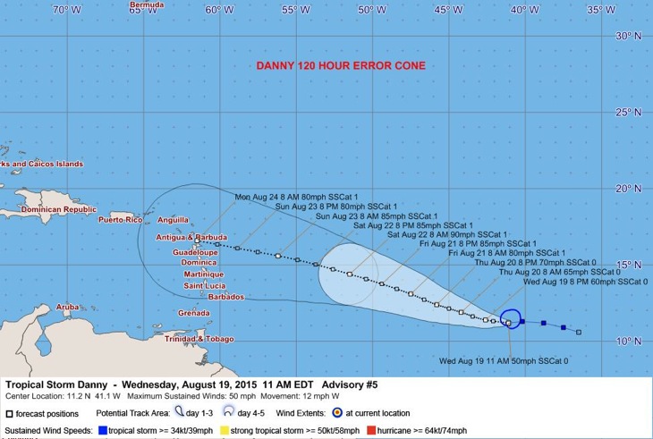
THE 11 a.m. is out and seems there is a bit more of north turn with the projection putting ERIKA to the north of Barbuda about 49 miles from the VC BIRD AIRPORT to the center of the storm ( that makes it about 62 miles away - to the center- for those on the South of Antigua) The storm force winds are expected to extend out 80 miles from the center. so that will give you an idea of what to feel. The speed is unsure yet but if she slows down it will be worse… The Hurricane Hunters fly her this afternoon so tonight we will have a much clearer picture of the wind speed, direction, barometric pressure, and other factors that alert us in advance on what to expect. BUT REMEMBER ALL OF THIS CAN CHANGE IN A SHORT TIME AS THESE SYSTEMS ARE dynamic and can wobble north or south and this changes the whole picture of which island gets hit. Best thing is to do all possible to be prepared sooner rather than later. 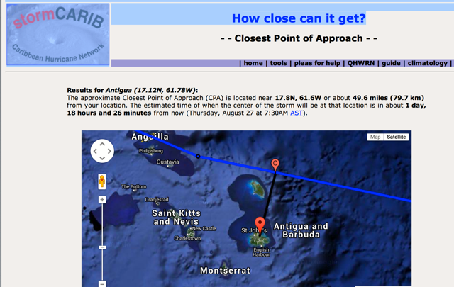 |
|
|
- TS Danny
|
- By Steve Selim <steve.in.antigua at gmail.com>
- Date: Tue, 25 Aug 2015 15:04:01 +0000
|
|
|
|
- THE BEAUTY OF A HURRICANE
|
- By Martha Gilkes <marthawatkinsgilkes at gmail.com>
- Date: Tue, 25 Aug 2015 10:55:36 -0400
|

PHOTO TAKEN INSIDE THE EYE OF HURRICANE FABIAN WHEN I FLEW WITH THE HURRICANE HUNTERS IN SEPTEMBER 2003. SHOWS THE BEAUTY OF A HURRICANE!
|
|
|
- Martha on TV!
|
- By Gert van Dijken <gert at vandijken.com>
- Date: Tue, 25 Aug 2015 07:47:41 -0700
|
Last Sunday our special hurricane correspondent Martha gave an interview on the Canadian CTV News Channel.
Here is a link to the interview:
Well done Martha! |
|
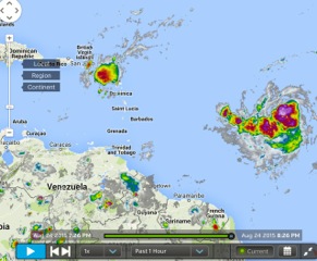
- STORM ERIKA COMING OUR WAY
|
- By Martha Gilkes <marthawatkinsgilkes at gmail.com>
- Date: Tue, 25 Aug 2015 10:30:20 -0400
|
| WE ARE WATCHING AND WILL SEE IF THE TRACK GOES NORTH OR STAYS CLOSER TO ANTIGUA and BARBUDA. The Hurricane hunters will fly the system later today and we will have a much better idea then.

Screen Shot 2015-08-24 at 5.32.25 PM
Screen Shot 2015-08-24 at 8.26.50 PM
Screen Shot 2015-08-25 at 10.12.29 AM
|
|
|
- Erika named in 11 pm advisory
|
- By Martha Gilkes <gilkesm at me.com>
- Date: Tue, 25 Aug 2015 02:17:02 -0400
|
Here we go again.    This will happen quickly.
Please Pay close attention.   Do anything needed to prepare early in case !
Martha Watkins Gilkes
P.O. Box W1924
Antigua, West Indies
268 460 4423
Cell 2687647722
Sent from my  fab iPhone
Marthawatkinsgilkes at gmail.com
|
|
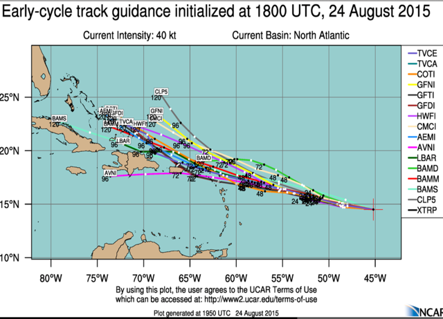
- OUR NEXT SYSTEM ???
|
- By Martha Gilkes <marthawatkinsgilkes at gmail.com>
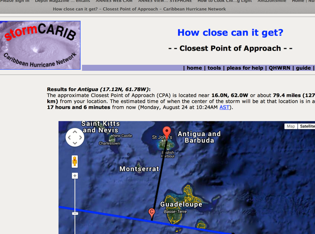
- Date: Mon, 24 Aug 2015 20:44:56 -0400
|
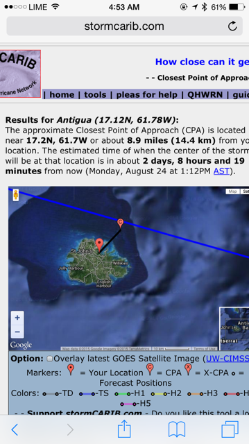
THEY WONT NAME IT YET!! ( I UNDERSTAND.. THE BIG BOYS HAVE TO BE SURE WITH DATA.. WE "AMATURES" CAN SPECULATE BUT I THINK IT IS GOOD TO KNOW WE HAVE SOMETHING ON TOP OF US SOON.. OR MAYBE NORTH OF US ?? JUST BE AWARE..
TROPICAL WEATHER OUTLOOK
NWS NATIONAL HURRICANE CENTER MIAMI FL
800 PM EDT MON AUG 24 2015

For the North Atlantic...Caribbean Sea and the Gulf of Mexico:

Thunderstorm activity associated with a low pressure system located
about 825 miles east of the Lesser Antilles has become a little
better organized today, although satellite wind data today suggest
that the system has not yet developed a fully closed surface
circulation.  Recent reports from a NOAA buoy indicate that the low
is producing winds to tropical-storm-force, and only a small
increase in organization would result in the formation of a tropical
storm as the system moves westward near 20 mph.  Interests in the
Leeward Islands should monitor the progress of this disturbance.
Additional information on this low can be found in high seas
forecasts issued by the National Weather Service.
* Formation chance through 48 hours...high...90 percent
* Formation chance through 5 days...high...90 percent
TAKEN FROM: |
|
|
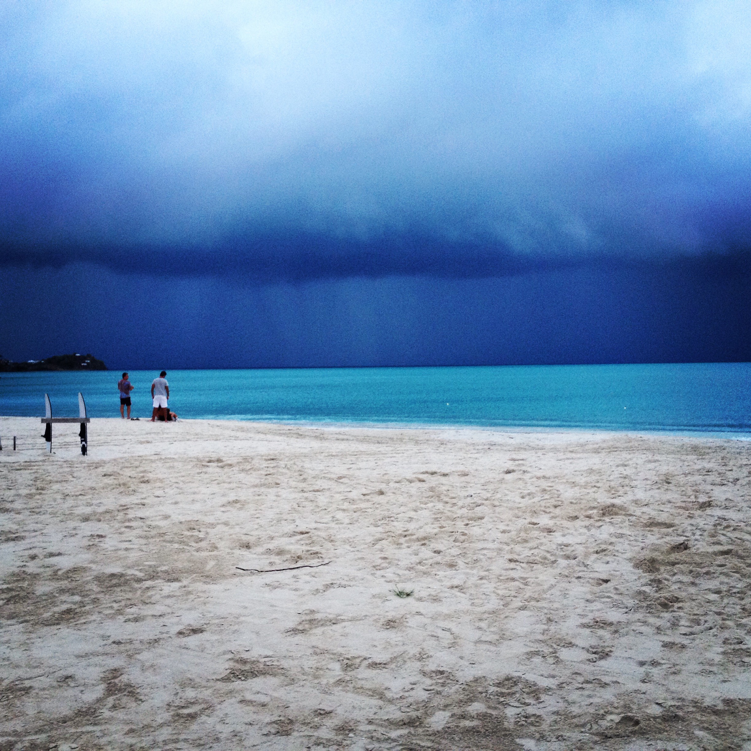
- WILD IS THE WIND !
|
- By Martha Gilkes <marthawatkinsgilkes at gmail.com>
- Date: Mon, 24 Aug 2015 20:02:29 -0400
|
|
|
|
- THE NEXT STORM
|
- By Martha Gilkes <marthawatkinsgilkes at gmail.com>
- Date: Mon, 24 Aug 2015 19:40:59 -0400
|
To those watching on STORM CARIB!
IT IS ALMOST CERTAIN what will be ERICKA WILL BE NAMED soon by the NAtional hurricane center and will be on THE SAME TRACK TO US AS DANNY but a BIGGER STORM.. we do not know the time line yet.. SO Here we go again.. many of these models put this to the NORTH of ANtiuga but it is early days..... The trick here is this system is only 950 miles to the east of us and clipping along at 20 plus MPH ( fast ) so she may be upon the islands quickly. WE NEED TO KEEP OUR SHUTTERS UP and do even more TO BE READY FOR A MORE MAJOR STORM. THIS ONE IS BIGGER AND DANNY HAS ALREADY TAKEN OUT THE DRY AIR THAT HELPED break him up so Ericka may not give up so easy!! Be Alert all! we may only have a few days... "storm tired" Martha!
|
|
|
- Antigua MET OFFICE Discontinues STROM WARNINGS
|
- By Martha Gilkes <marthawatkinsgilkes at gmail.com>
- Date: Mon, 24 Aug 2015 06:42:00 -0400
|
WE ARE OFF STORM WARNINGS as of the 5 a.m. National Hurricane Center according to the MET OFFICE HOT LINE RECORDING I just listened to. This means we will NOT GET ANY STORM FORCE WINDS and are out of the danger zone. Will have to check on when airport reopens and other such services. We have NO electricity here in the South but I find that odd as we have not had strong winds so hope it is restored soon. We do hope we have some more RAIN CLOUDS COMING. ( and looking at the radar it seems so...
Meanwhile we now need to watch what is behind DANNY so I am in NO RUSH TO REMOVE my hurricane shutters! THANKS TO ALL WHO WERE INTERESTED IN WHAT WAS HAPPENING IN OUR LIVES HERE IN ANTIGUA AND a special thanks to GERT OF STORM CARIB for creating and maintaining this site since 1996 so we have a place to report on all of this... Please consider making a small donation ( or a large one!) to STORM CARIB.. there is a link on the home page! I mention this because I personally want to see STORM CARIB STAY ON LINE. am sure you agree if you are one of the regular readers. I know Gert has personally financed much of this cause!
Happy Monday and following week to all.
|
|
|
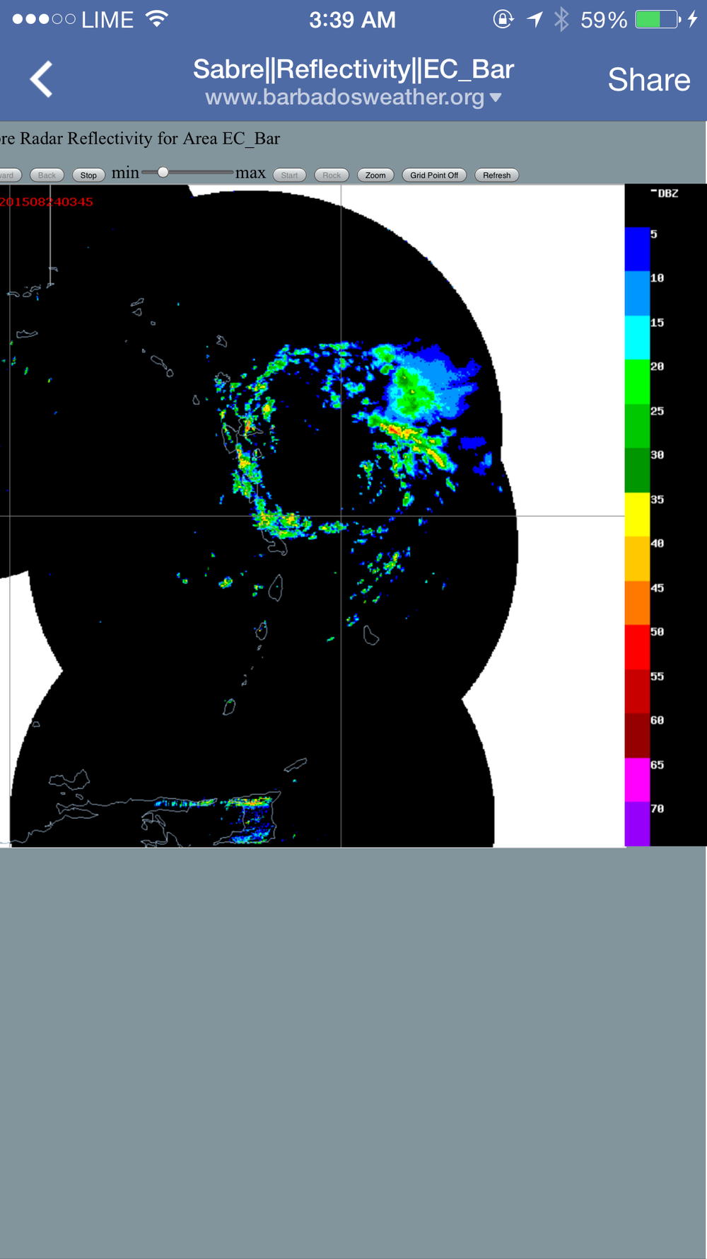
- Storm over Antigua.
|
- By Martha Gilkes <gilkesm at me.com>
- Date: Mon, 24 Aug 2015 03:47:46 -0400
|
This link puts it in motion. Below a still photo of it now 3:44 am. Antigua is under the leading edge of the circle Rain is off and on. Not much wind. Thank goodness ! |
|
|
- DOUBTFUL DANNY
|
- By Martha Gilkes <marthawatkinsgilkes at gmail.com>
- Date: Sun, 23 Aug 2015 21:11:31 -0400
|
DOUBTFUL DANNY I AM DUBBING THIS system DOUBTFUL DANNY as this storm has jumped all over the place from being labeled a MAJOR HURRICANE (CAT 3) down to barely a Tropical Storm - he cant make up his mind what he is doing.. but for now he is maintaining Tropical Storm status.. not only has he interrupted our lives for several days, he called out the Hurricane Hunters for 3 days now ( at a big ticket price!) Even our Met office isn't sure what to make of DANNY ( just listened to the evening weather..) and they cant make a call yet to call off our Tropical Storm Warning and to declare tomorrow a normal working day. They say they want to wait on the 11 p.m. report..and they say DANNY - 210 miles off to our east - could still turn more NORTH or could TURN MORE SOUTH ????? go figure ?? WE KNOW DANNY has moisture surrounding the system so COME ON AND GIVE US SOME BADLY NEEDED RAIN!!
Looking at the SAT photo and the mass of clouds dancing around I BELIEVE WE WILL GET RAIN in the wee hours We just had aired on our local TV a special "WEATHER WATCH" and coming from this was the following interesting points with Keithly Meades of MET OFFICE.
*Danny is presently continuing the path towards the LEEWARDS west north west at 14 MPH
*MAX sustained wind of 50 MPH but expecting 40 to 45 MPH winds but there are additional gusts up to 50 MPH ( not the type of wind that will remove a house roof...but can do tree and garden damage)
*Center expected to pass south of Antigua during early morning ( but COULD wobble and come back north!)
*EXPECT rain and thunderstorms - 1 to 4 inches expected (hoping to get as much as Danny will give ) between 2 a.m. and 8 a.m. ( this could lead to flash flooding in low lying areas so be aware)
*For the next few hours conditions will continue to be cloudy and the leading edge will come on us around 2 a.m. and the rest of the mass of clouds that comes after the leading edges will have showers and embedded thunderstorms
*DRY CONDITIONS AND WIND SHEER is keeping Danny weaker
* Being a SMALL system is can increase or decrease quickly
* STORMS and SYSTEMS and Hurrianes DO NOT TRAVEL in a straight line.. They can wobble up to 50 miles one way or the other so it can move back and forth as has been the case with Danny.
* Barbuda is further away and SHOULD PREPARE but is more out of the line at this point
* Storm force winds extend out 60 miles so depending on where DANNY finally passes we may or may not get the storm winds
* Discussion on:
WE had a storm that started as normal... went to CAT 3 MAJOR hurricane and then quickly dropped to a Tropical storm.
DUE TO SHEER.. SHEER is a difference of wind speed between the levels of wind ( the different layers of wind) At the upper levels there is 20 to 30 knots. ANY HURRICANE needs a good upper level out flow of winds and if there is sheer of the winds ( which is caused by El Nino- strong upper level winds - this helps keep the storms from developing.
AND finally
IF YOU ARE GOING TO PREPARE PREPARE FOR THE WORST
Hope relating these bullet points help someone!! Have a good night and stay safe.. at least we are not facing something like a CAT 4 LUIS STORM and we know we will wake up with electricity and services still in tact ! It has been a GOOD WAKE UP for us all to "practice" our being prepared!
|
|
|
- STORM DANNY
|
- By Martha Gilkes <marthawatkinsgilkes at gmail.com>
- Date: Sun, 23 Aug 2015 18:44:22 -0400
|
|
|
|
- 5 PM UPDATE STORM DANNY
|
- By Martha Gilkes <marthawatkinsgilkes at gmail.com>
- Date: Sun, 23 Aug 2015 17:58:37 -0400
|
IT IS VERY CONFUSING AS ANTIGUA IS STILL ON A STORM WARNING BUT YET THE 5 P.M. SHOWS THIS:
DANNY IS NOW SHOWN AS BEING 79 MILES AWAY AS OF TOMORROW ( MONDAY) WHEN IT IS IN OUR AREA... AS THERE WAS A TURN TO THE SOUTH SO WE MAY NOT EVEN GET |
|
|
- STORM DANNY APPROACHING ANTIGUA
|
- By Martha Gilkes <marthawatkinsgilkes at gmail.com>
- Date: Sun, 23 Aug 2015 13:29:30 -0400
|
|
|
|
- Storm Danny interview with Canadian TV station
|
- By Martha Gilkes <gilkesm at me.com>
- Date: Sun, 23 Aug 2015 11:29:25 -0400
|
Attachment:
New Recording 2.m4a (fixed version)
Description: audio/m4a
Martha Watkins Gilkes
|
|
- STORM DANNY 11 a.m on SUNDAY
|
- By Martha Gilkes <marthawatkinsgilkes at gmail.com>
- Date: Sun, 23 Aug 2015 10:55:16 -0400
|
| 11 a.m today SUNDAY news even better for Antigua as Danny is staying SOUTH and is now expected to be 43 miles from our International Airport when the center is passing us ( for those of us who live in the south - 14 miles from the airport that puts the storm within about 30 miles of us and the storm winds extend out 60 MILES so we will still get some storm force winds... and hopefully some RAIN. But it seems it wont be nearly the "bad weather" event it could be. Lets hope Danny does not gain strength and bring harm to islands north of us. So we are now looking at an area of concern about to come off the African coast that already has 40% chance to develop into a major hurricane! It is the height of hurricane season!
Martha 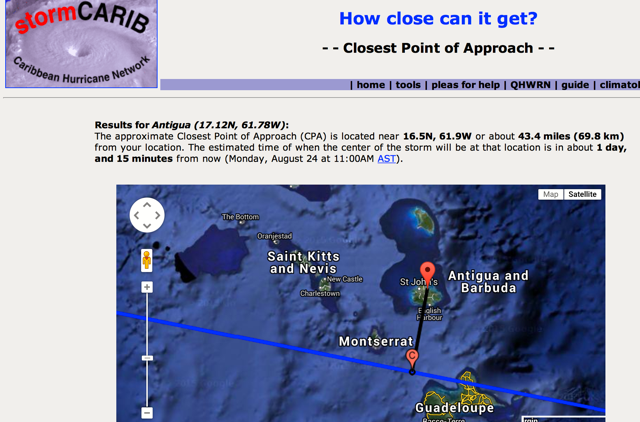
|
|
|
- DANNY 5 a.m Sunday morning
|
- By Martha Gilkes <marthawatkinsgilkes at gmail.com>
- Date: Sun, 23 Aug 2015 05:15:28 -0400
|
The West track continued between 2 am and 5 am and now puts Danny's center a bit more to the south of Antigua as shown in this track... with winds at 50 MPH which is a Tropical Storm and not a hurricane, thank goodness. But they are saying RAIN so that is exactly what we were hoping for... we still have about 30 hours to wait for the passing of the center but will start getting the rain and the tropical winds long before... My big metal hurriane shutters going up in a few hours to BE READY! and as always THINGS CAN CHANGE to monitoring is the key to know what is going on. Happy the Hunters will fly it again soon for more accurate info.... Lots to do today.. so will get going very soon! KEEP SAFE all in the storms path.
Martha 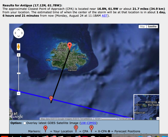
|
|
|
- DANNY 2 a.m. report
|
- By Martha Gilkes <marthawatkinsgilkes at gmail.com>
- Date: Sun, 23 Aug 2015 04:50:33 -0400
|
As I feared last night when i read about the ridge of high pressure to the north of the system that was going to possibly drive it due west... which seems to have happened as shown here. My last posting had the system to the NORTH of Antigua... Now it seems ( AS OF 2 AM) it will be SOUTH of ANTIGUA as shown here. My house is just below FREETOWN on the map... on the sea... so this will be right over us on the south of the island. We still have some time to go so there may be ANOTHER CHANGE. That is how it goes with these systems and why we have to be prepared as things can change in a hurry. The winds have died down somewhat but we still have to watch it! HOPEFULLY THE VERY NEEDED RAIN WILL COME. STANDING BY...
|
|
|
- 5 p.m. PROJECTED TRACK of DANNY
|
- By Martha Gilkes <marthawatkinsgilkes at gmail.com>
- Date: Sat, 22 Aug 2015 16:56:45 -0400
|
| THIS is looking better for Antigua as this puts the eye of DANNY 24 miles away on MONDAY around NOON IF IT STAYS ON THIS TRACK. The thing about these storms is NOTHING IS WRITTEN IN STONE... but this is looking better as far as wind damage is concerned.. We DO HOPE FOR RAIN however!! STILL STANDING BY
Screen Shot 2015-08-22 at 4.49.07 PM
|
|
|
- THE CREATOR OF STORM CARIB
|
- By marthawatkinsgilkes at gmail.com
- Date: Sat, 22 Aug 2015 15:41:37 -0400
|
SORRY TO BE POSTING A "NON- HURRICANE " post BUT THIS IS THE CREATOR OF STORM CARIB --- GERT --- WHEN I WAS FORTUNATE TO MEET HIM SOME YEARS AGO in San Francisco WITH HIS 2 YOUNG TWINS! Gert has put his heart and soul AND MONEY into keeping STORMCARIB going for years now to INFORM those who want to know about their families and friends in the islands during a hurricane.. WITHOUT THIS THERE IS NO INFO on what is happening in the islands! Those of us who report are volunteers and are happy to help keep the information flowing! I WOULD LIKE TO APPEAL TO THOSE WHO ARE FOLLOWING TO CONSIDER A DONATION TO THE CAUSE. THERE IS A LINK ON THE MAIN PAGE... IT SURE IS FOR A GOOD CAUSE!
TO HURRICANE REPORTING! Martha
|
|
|
- HURRICANES HUNTER PLAN OF TODAY
|
- By Martha Gilkes <marthawatkinsgilkes at gmail.com>
- Date: Sat, 22 Aug 2015 14:52:14 -0400
|
Plan of the Day
000
NOUS42 KNHC 221627
REPRPD
WEATHER RECONNAISSANCE FLIGHTS
CARCAH, NATIONAL HURRICANE CENTER, MIAMI, FL.
1230 PM EDT SAT 22 AUGUST 2015
SUBJECT: TROPICAL CYCLONE PLAN OF THE DAY (TCPOD)
         VALID 23/1100Z TO 24/1100Z AUGUST 2015
         TCPOD NUMBER.....15-088

I.  ATLANTIC REQUIREMENTS
    1. HURRICANE DANNY
       FLIGHT ONE -- NOAA 43          FLIGHT TWO -- TEAL 75
       A. 23/2000Z                    A. 23/2330Z
       B. NOAA3 0504A DANNY           B. AFXXX 0604A DANNY
       C. 23/1800Z                    C. 23/2130Z
       D. 16.4N 57.7                  D. 16.6N 58.7W
       E. 23/1930Z TO 23/2300Z        E. 23/2300Z TO 24/0300Z
       F. SFC TO 15,000FT             F. SFC TO 15,000FT

       FLIGHT THREE -- NOAA 43        FLIGHT FOUR -- TEAL 73
       A. 24/0800Z                    A. 24/1130Z,1730Z
       B. NOAA3 0704A DANNY           B. AFXXX 0804A DANNY
       C. 24/0600Z                    C. 24/1020Z
       D. 16.9N 60.0W                 D. 17.2N 61.3
       E. 24/0730Z TO 24/1000Z        E. 24/1100Z TO 24/1400Z
       F. SFC TO 15,000FT             F. SFC TO 15,000FT

    2. OUTLOOK FOR SUCCEEDING DAY: CONTINUE 6-HRLY FIXES.
    3. REMARKS: NOAA'S G-IV WILL DO A RESEARCH MISSION AROUND
       DANNY AT 23/1530Z.
       NASA'S DC-8 WILL DEPART KFLL 23/1100Z FOR A 6 HR RESEARCH
       MISSION AROUND DANNY. FLIGHT LEVEL 35,000FT. NO DROPS.
|
|
Martha
|
|
|
- HURRICANE DANNY 11 AM ADVISORY JUST OUT
|
- From: Martha Gilkes <marthawatkinsgilkes at gmail.com>
- Date: Sat, 22 Aug 2015 11:10:33 -0400
|
DANNY IS  NOW A  CAT 2  HURRICANE WITH  WINDS AT  90 MPH ( DROPPED FROM  100 MPH FROM 5 A.M )
SUMMARY OF 1100 AM AST...
IT IS ALSO CLOSER TO US
-----------------------------------------------
LOCATION...15.4N 52.0W
ABOUT 660 MI.. E OF THE LEEWARD ISLANDS
PRESENT MOVEMENT...WNW 12 MPH ( GOING A BIT FASTER NOW...WAS 10 MPH AT 5 A.M. ...
OUR   Meteorological Service of Antigua has issued a tropical storm
watch for Antigua, Barbuda, Montserrat, St. Kitts, Nevis, and
Anguilla.   THIS   means that tropical storm conditions are
possible within the watch area, generally within 48 hours.
THEY KEEP TALKING ABOUT IT GETTING WEAKER AS IT KEEPS APPROACHING... WHICH WE HOPE will be the case. Watching - waiting and doing hurricane preparedness....
IT is a beautiful day here now but very still and HOT even on the EAST COAST at Half Moon Bay!
|
|
|
- FLIGHTS BEING CANCELLED in and out of Antigua
|
- From: Martha Gilkes <gilkesm at me.com>
- Date: Sat, 22 Aug 2015 07:53:18 -0400
|
LIAT will stop flights into and out of Antigua from 2 p.m TOMORROW SUNDAY.. this is on their web site.. Am sure the International airlines will also be canceled ... check with the specific airline for more...
We will hope as soon as the storm passes we will be back to normal as quickly as possible..
TODAY IS A BUSY DAY FOR US IN THE ISLANDS with HURRICANE preparation ....
Hurricane Danny – Advisory # 2 ISSUED AT 5:30PM – AUGUST 21, 2015 ST. JOHN’S, Antigua – LIAT wishes to advise that due to the impending passage of Hurricane Danny, it has been forced to cancel the following services for Sunday, August 23, Monday, August 24 and Tuesday, August 25:
Martha
|
|
|
- Danny. Closest point today Saturday
|
- From: Martha Gilkes <gilkesm at me.com>
- Date: Sat, 22 Aug 2015 05:01:06 -0400
|
Martha Watkins Gilkes
P.O. Box W1924
Antigua, West Indies
268 460 4423
Cell 2687647722
Sent from my  fab iPhone
Marthawatkinsgilkes at gmail.com
|
|
- Danny creeping north
|
- From: Martha Gilkes <gilkesm at me.com>
- Date: Sat, 22 Aug 2015 04:51:29 -0400
|
| Hurricane DANNY (click for details) |
As of 0500 AM AST Sat Aug 22 (Advisory # 16)
Saffir-Simpson Wind Scale: Category 2
Maximum Sustained Winds: 85 knots; 100 mph
Minimum Central Pressure: 982 mb
Located at: 15.2N 50.8W
Movement: west-northwest at 9 knots; 10 mph
|
|
|
|
|
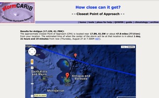
- 5 P.M. FRIDAY HURRICANE DANNY FORECAST
|
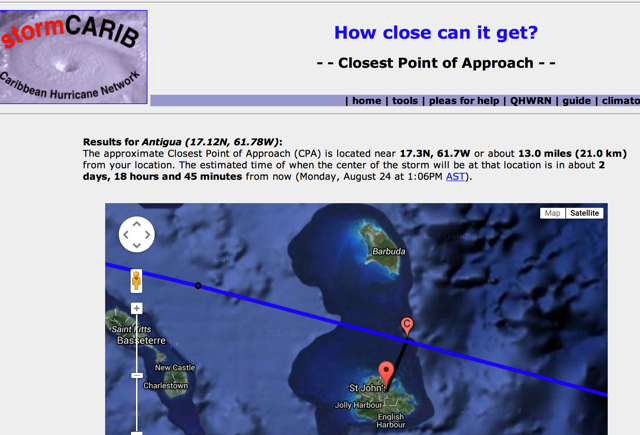
- From: Martha Gilkes <marthawatkinsgilkes at gmail.com>
- Date: Fri, 21 Aug 2015 18:34:28 -0400
|
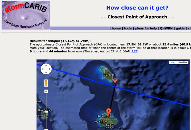
IN 72 HOURS ON AUGUST 24TH THE PROJECTED CLOSEST POINT TO ANTIGUA IS SHOWN HERE.. WE ARE 17.1 N AND 61.8 THEY ARE PROJECTING IT TO BE A TROPICAL STORM AT 65 MPH HERE.. THAT IS GOOD NEWS.. HOPEFULLY WITH LOTS OF RAIN FOR OUR ISLAND FORECAST POSITIONS AND MAX WINDS
INIT 21/2100Z 14.5N 49.1W 100 KT 115 MPH CAT-3
12H 22/0600Z 15.0N 50.5W 95 KT 110 MPH CAT-2
24H 22/1800Z 15.5N 52.7W 85 KT 100 MPH CAT-2
36H 23/0600Z 15.9N 55.2W 70 KT 80 MPH CAT-1
48H 23/1800Z 16.3N 57.8W 60 KT 70 MPH TS
72H 24/1800Z 17.5N 62.5W 55 KT 65 MPH TS
THIS IS FROM THE 5 P.M NHC ... IT HAS MOVED THE SYSTEM SLIGHTLY TO THE NORTH OF US NOW 13 MILES AWAY
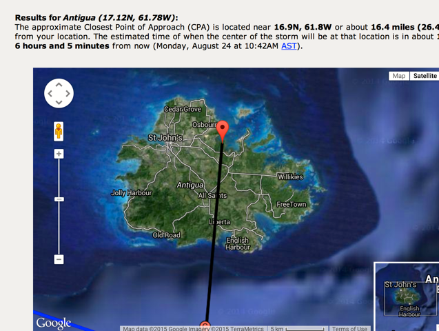
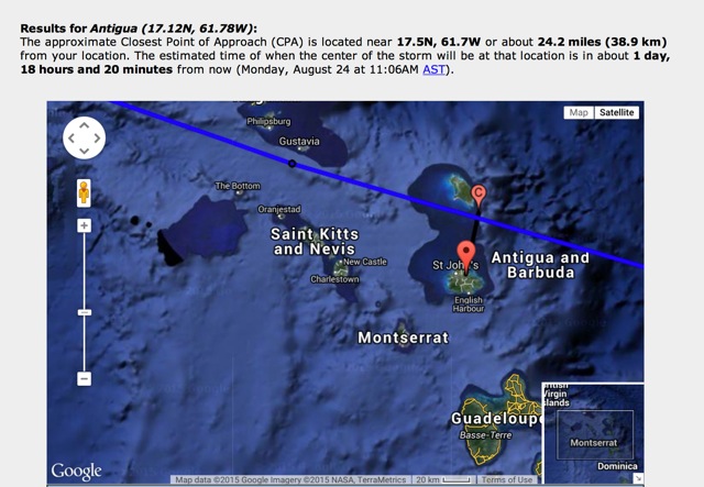
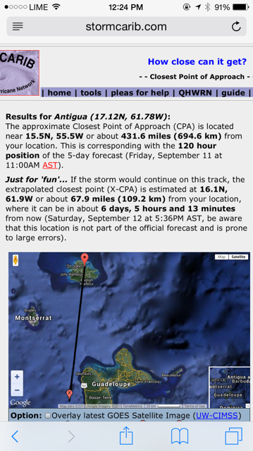
Results for Antigua (17.12N, 61.78W):The approximate Closest Point of Approach (CPA) is located near 17.3N, 61.7W or about 13.0 miles (21.0 km)from your location. The estimated time of when the center of the storm will be at that location is in about 2 days, 18 hours and 45 minutes from now (Monday, August 24 at 1:06PM AST).
Martha
|
|
|
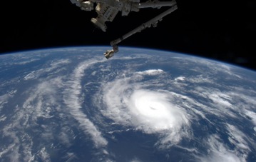
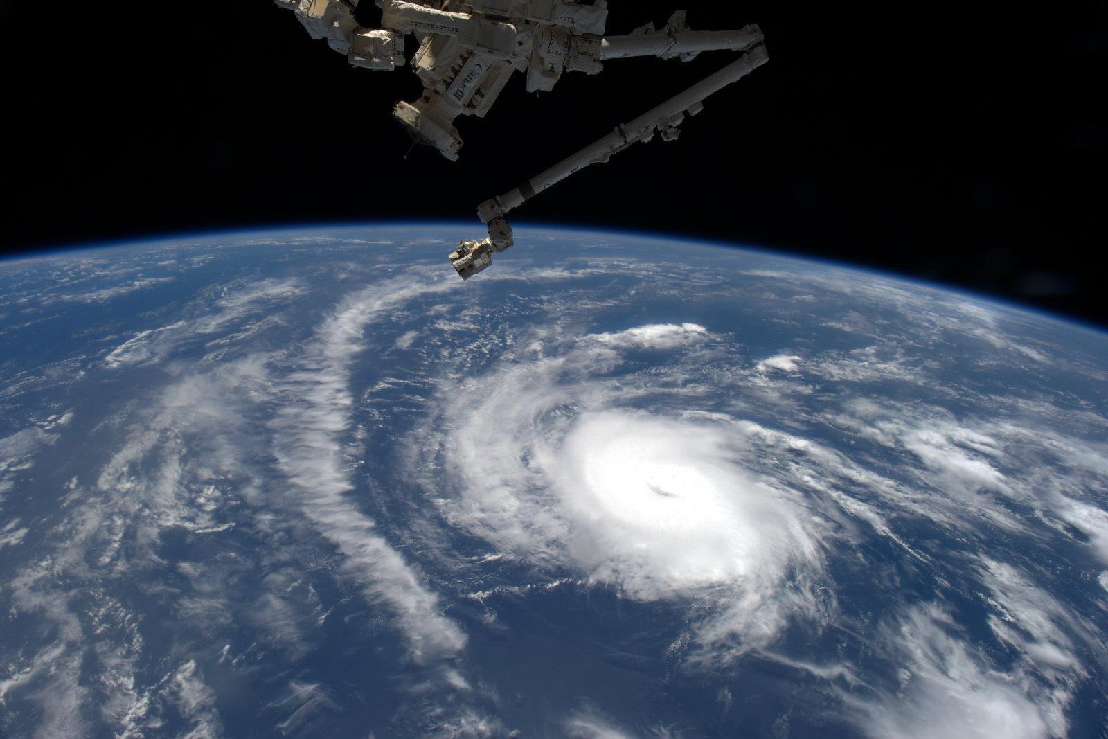
- STUNNING DANNY PHOTO FROM SPACE STATION
|
- From: Martha Gilkes <marthawatkinsgilkes at gmail.com>
- Date: Fri, 21 Aug 2015 17:42:24 -0400
|
|
|
|
- HURRICANE DANNY
|
- From: Martha Gilkes <marthawatkinsgilkes at gmail.com>
- Date: Fri, 21 Aug 2015 17:23:59 -0400
|
|
|
|
- INTERVIEW ON THE HURRICANE WITH CTV NEWS IN TORONTO
|
- From: Martha Gilkes <marthawatkinsgilkes at gmail.com>
- Date: Fri, 21 Aug 2015 16:22:19 -0400
|
Was contacted by a chase producer with CTV News Channel in Toronto, Canada; 24-hour news network broadcasting nationally across Canada.
Will do an interview with them on SUNDAY MORNING at 11:10 A.m. so if you are CANADA BASED and around do tune in...
Martha
|
|
|
- Hurricane Danny
|
- From: Martha Gilkes <marthawatkinsgilkes at gmail.com>
- Date: Fri, 21 Aug 2015 16:19:18 -0400
|
Antigua is taking the Hurricane serious with lots of preparations especially as last October Hurricane GONZALO TOOK US ALL BY SURPRISE. The APUA ( Electricity) is going all over the island trimming trees overhanging electrical lines. I have reported a big tree on the main Half Moon Road that overhangs the main lines coming to Half Moon in the hope they will deal with that.. THEY ASK ANYONE WHO SEES OVERHANGING BRANCHES call 311.
Meanwhile, DANNY HAS BECOME A MAJOR STORM - as of 2 p.m. A CAT 3 (am sure most of you are following this) - based on info from a NOAA Aircraft that just flew the system but it was expected that it would gain strength.. They do expect it to weaken again by Sunday. so lets hope they are right THAT IT WILL DROP BACK as it nears the islands... The next days will tell.
The "Closet point" Tool on www.stormcarib.com now put Hurricane Danny only 3.9 MILES over us! Results for Antigua (17.12N, 61.78W):
The approximate Closest Point of Approach (CPA) is located near 17.1N, 61.8W or about 3.9 miles (6.2 km)from your location. The estimated time of when the center of the storm will be at that location is in about 2 days, 21 hours and 24 minutes from now (Monday, August 24 at 12:36PM |
Then Click on
THEN CHECK THE CHOICE NON TASKED MISSION ( DANNY) THEN CHECK ALL THE SMALL BOXES ON THE BOTTOM OF THE SCREEN AND YOU WILL SEE WHERE THE FLIGHT IS...
THIS IS THE PRESENT PLAN OF THE DAY
NOUS42 KNHC 211555
REPRPD
WEATHER RECONNAISSANCE FLIGHTS
CARCAH, NATIONAL HURRICANE CENTER, MIAMI, FL.
1155 AM EDT FRI 21 AUGUST 2015
SUBJECT: TROPICAL CYCLONE PLAN OF THE DAY (TCPOD)
         VALID 22/1100Z TO 23/1100Z AUGUST 2015
         TCPOD NUMBER.....15-087

I.  ATLANTIC REQUIREMENTS
    1. HURRICANE DANNY
       FLIGHT ONE -- TEAL 73          FLIGHT TWO -- NOAA 43
       A. 22/2000Z                    A. 22/2000Z
       B. AFXXX 0104A DANNY           B. NOAA3 0204A DANNY
       C. 22/1630Z                    C. 22/1800Z
       D. 15.4N 53.4W                 D. 15.4N 53.4W
       E. 22/1900Z TO 22/2100Z        E. 22/1930Z TO 22/2200Z
       F. SFC TO 15,000FT             F. SFC TO 15,000FT

       FLIGHT THREE -- NOAA 43        FLIGHT FOUR -- TEAL 74
       A. 23/0800Z                    A. 23/1200Z
       B. NOAA3 0304A DANNY           B. AFXXX 0404A DANNY
       C. 23/0600Z                    C. 23/0645Z
       D. 15.8N 55.2W                 D. 16.0N 56.4W
       E. 23/0800Z TO 23/1200Z        E. 23/1100Z TO 23/1400Z
       F. SFC TO 15,000FT             F. SFC TO 15,000FT

    2. OUTLOOK FOR SUCCEEDING DAY: CONTINUE 12-HRLY FIXES.
       ANOTHER P-3 TAIL DOPPLER RADAR FLIGHT AT 23/1800Z.
 3. REMARKS: NOAA'S G-IV WILL DO RESEARCH MISSIONS AROUND
       DANNY AT 22/1730Z AND 23/1730Z.
THANKS TO THOSE WHO ARE SENDING GOOD WISHES !
|
|
|
- FOLLOW LIVE DATA FROM THE HURRICANE HUNTERS
|
- From: Martha Gilkes <marthawatkinsgilkes at gmail.com>
- Date: Fri, 21 Aug 2015 14:18:33 -0400
|
|
|
|
- FOLLOWING THE HURRICANE HUNTERS REAL TIME
|
- From: Martha Gilkes <marthawatkinsgilkes at gmail.com>
- Date: Fri, 21 Aug 2015 12:50:18 -0400
|
IF YOU WANT TO FOLLOW THE HURRICANE HUNTER PLANE GOING INTO HURRICANE DANNY RIGHT NOW CLICK THE LINK BELOW.. THEN CHECK THE CHOICE CHECK NON TASKED MISSION ( DANNY) THEN CHECK ALL THE SMALL BOXES ON THE BOTTOM OF THE SCREEN AND YOU WILL SEE WHERE THE FLIGHT IS...
WE WILL SOON KNOW MUCH MORE ON HOW STRONG THIS HURRICANE IS AT THIS TIME AND POINT.
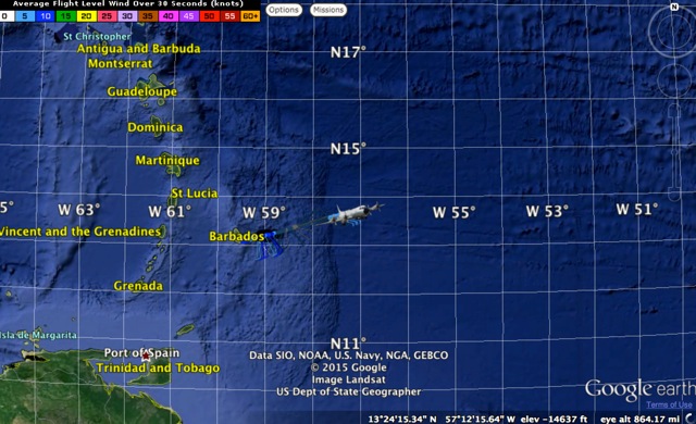
http://tropicalatlantic.com/recon/recon.cgi?basin=al&mapping=google_earth_plugin
|
|
|
- HURRICANE HUNTERS going into Hurricane Danny
|
- From: Martha Gilkes <marthawatkinsgilkes at gmail.com>
- Date: Fri, 21 Aug 2015 10:23:17 -0400
|
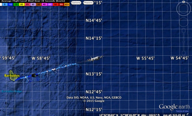
Just learned a bit more about the plans for the Hurricane Hunters.. they will be flying an Alpha pattern at least 2 times thru the eye as they gather weather reading. These reading are used to help protect coastal areas with more accurate information of the speed and direction and other data that helps those on land know what is coming. They fly at 10,000 feet ( sometimes down to 5,000 feet if the system is weaker. They are limited to fly starting at 55 degress due to fuel supply. (as shown below the hurricane is at 47.4 so has to get closer to fly it) As I post this 10 a.m. Friday the hurricane is 985 miles east of the leewards This is of 5 a.m AST Friday morning
Location: 13.7°N 47.4°W
Moving: WNW at 10 mph
Min pressure: 987 mb
Max sustained: 85 mph
An article about this.....
http://www.caribbean360.com/news/hurricane-hunter-sent-to-barbados-to-gather-information-about-tropical-storm-danny
Plan of the Day
000
NOUS42 KNHC 201602
REPRPD
WEATHER RECONNAISSANCE FLIGHTS
CARCAH, NATIONAL HURRICANE CENTER, MIAMI, FL.
1145 AM EDT THU 20 AUGUST 2015
SUBJECT: TROPICAL CYCLONE PLAN OF THE DAY (TCPOD)
         VALID 21/1100Z TO 22/1100Z AUGUST 2015
         TCPOD NUMBER.....15-086

I.  ATLANTIC REQUIREMENTS
    1. NEGATIVE RECONNAISSANCE REQUIREMENTS.
    2. OUTLOOK FOR SUCCEEDING DAY: BEGIN 12-HRLY FIXES ON
       HURRICANE DANNY AT 22/2000Z NEAR 15.4N 52.7W AND AT
       23/1200Z NEAR 16.0N 56.4W.
    3. REMARKS: P-3 TAIL DOPPLER RADAR MISSIONS INTO DANNY
       EVERY 12 HOURS BEGINNING AT 22/1800Z. NOAA'S P-3
       AND G-IV WILL DO RESEARCH MISSIONS AROUND DANN
|
|
|
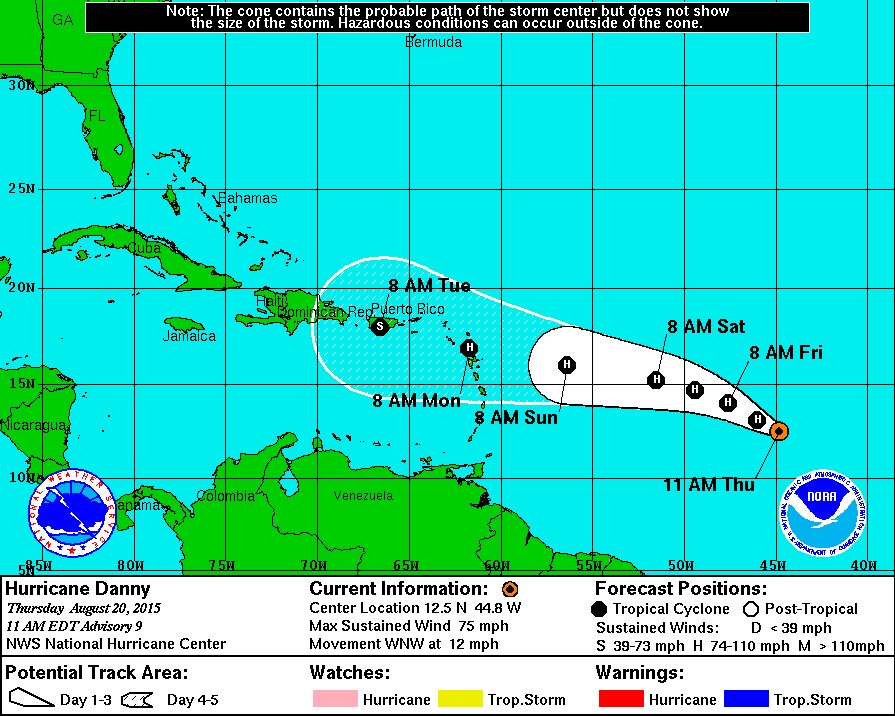
- HURRICANE DANNY How close is it coming to Antigua
|
- From: Martha Gilkes <marthawatkinsgilkes at gmail.com>
- Date: Fri, 21 Aug 2015 09:42:22 -0400
|
| USING THIS COOL TOOL ON THE STORM CARIB SITE (www.stormcarib.com) we can project how close Hurricane Danny will come to us. (each island can do this by changing the settings) This shows DANNY 10 miles away at its closest point... or nearly RIGHT OVER US! AND TO THE SOUTH. IF IT STAYS AT THE PRESENT SPEED IT IS MOVING IT WILL BE HERE MONDAY AROUND 11 A.M... BUT IT COULD SLOW DOWN.. OR GAIN SPEED. THE HURRICANE GAINED STRENGTH OVERNIGHT TO 85 MILES PER HOUR.. THERE ARE SOME intensity models that suggest that Danny will have some wind shear over the next couple of days which may cause the wind to drop. This hurricane is a tough one to predict and only time will tell. As this is a SMALL HURRICANES ( as hurricanes go..) it makes it susceptible to sudden changes in intensity and thus more difficult to predict. so the best thing for people to do is to be prepared FOR THE WORST. Also the HURRICANE HUNTER will be flying the storm out of Barbados later today so that is good as the info they gather is MUCH MORE ACCURATE than anything we get from satellite. So we will have a more accurate picture of what we are facing later today.
|
|
|
- Overcast and rain
|
- From: "scholla candw.ag" <scholla at candw.ag>
- Date: Fri, 21 Aug 2015 08:05:08 -0400 (EDT)
|
Quiet day but very overcast and a few sprinkles so far. Hurricane DANNY's wind speed is forecasted to be reduced to a Tropical Storm by the time it passes through the Leewards. We are all hoping for some rain but it is a small foot print so we shall see.
Alan
|
|
- ANTIGUA GETTING READY FOR DANNY
|
- From: Martha Gilkes <marthawatkinsgilkes at gmail.com>
- Date: Fri, 21 Aug 2015 07:34:38 -0400
|
| GOOD MORNING FROM ANTIGUA to all who are following us here on the island.... we are all watching DANNY and there is much on our radio and TV to GET READY. Last year we were caught with a surprise storm (Gonzoles) that did a lot of damage and sank boats etc because we were told it was just a little storm so this is making many take notice. I will certainly put up all HURRICANE SHUTTERS by Sunday afternoon. Also our Antigua Public Utility Company is making calls for people to report any overhanging trees as they are doing a big prune job to get ready for the storm.. so Antigua is getting prepared..a good thing... There is some talk that DANNY will lose some force as it nears the islands which would be good as the damage from the wind would not be as bad and hopefully we will get VERY NEEDED RAIN. I have been reporting on these storm since GERT LAUNCHED this wonderful STORM CARIB SITE after the terrible Hurricane LUIS in 1995 and people living overseas were desperate to learn what had happened on their islands. Gert has provided a BIG SERVICE to all of us in the Leewards and Windwards.. THANK YOU SIR!!!
|
|
|
- Morning Shower and Gonzalo Update.
|
- From: Maleek Joseph <maleek1998 at hotmail.com>
- Date: Fri, 21 Aug 2015 07:04:30 -0400
|
| Hurricane Dany strengthened a bit this morning.
The 5 AM Local time details are as follows:
LOCATION: 13.7N 47.4W ABOUT 985 MI (1590 KM) ESE OF THE LEEWARD ISLANDS MAXIMUM SUSTAINED WINDS: 85 MPH (140 KM/H) PRESENT MOVEMENT: WNW AT 10 MPH (17 KM/H) MINIMUM CENTRAL PRESSURE: 987 MB (29.15 INCHES) Based on the latest track and information, Danny is expected to pass near Antigua and Barbuda on Monday. Watches and Warnings may be required within 24 to 48 hours and residents are being asked to be prepared to act if necessary.
Meanwhile, low level convergence and high moisture levels caused cloudy skies and a few heavy downpours in Antigua overnight and this morning. Showers are still possible, mainly this morning; Partly cloudy conditions are expected thereafter.
I will post and update on Danny later today; if time permits, until then, I am Khalil Joseph reporting.
|
|
|
- FLYING INTO THE EYE OF A HURRICANE
|
- From: Martha Gilkes <marthawatkinsgilkes at gmail.com>
- Date: Thu, 20 Aug 2015 13:56:56 -0400
|
CHECK out my "FLIGHT ON THE WILD SIDE".. flying into a CAT 4 Hurricane with the Hurricane Hunters... Sure gave me a "BIRDS EYE VIEW" of a hurricane.
|
|
|
- HURRICANE DANNY FROM SPACE
|
- From: Martha Gilkes <marthawatkinsgilkes at gmail.com>
- Date: Thu, 20 Aug 2015 13:19:03 -0400
|
|
|
|
- MORE ON DANNY
|
- From: Martha Gilkes <marthawatkinsgilkes at gmail.com>
- Date: Thu, 20 Aug 2015 13:18:31 -0400
|
Danny is now a hurricane....This was expected, as the system is moving through a favorable environment and will continue to do so for the next day or so.
Danny is still forecast to run headlong into a wall of wind shear closer to the islands, and this should cause a weakening of the system according to the forecast........How much is unknown, but the official forecast suggests that Danny will still be a hurricane when it passes very near to us on Monday morning.
Important to note that Danny is an unusually small cyclone, and the hurricane force winds only extend out about 10 miles from the center, so small deviations in track could make a huge difference in conditions over the affected areas.
|
|
|
- AN IMPRESSIVE PHOTO OF HURRICANE DANNY FROM SPACE Just Taken
|
- From: Martha Gilkes <marthawatkinsgilkes at gmail.com>
- Date: Thu, 20 Aug 2015 12:48:23 -0400
|
|
|
|
- HURRICANE HUNTERS TO BEGIN FLYING HURRICANE DANNY
|
- From: Martha Gilkes <marthawatkinsgilkes at gmail.com>
- Date: Thu, 20 Aug 2015 11:05:29 -0400
|
THIS IS THE offical plan for the HURRICANE HUNTERS to fly Hurricane Danny which will give MUCH more accurate info on the system than what we can get from satellite. So when Danny gets near 14.8 N they will fly into it.. It is now 12.5 N
Plan of the Day
000
NOUS42 KNHC 191426
REPRPD
WEATHER RECONNAISSANCE FLIGHTS
CARCAH, NATIONAL HURRICANE CENTER, MIAMI, FL.
1030 AM EDT WED 19 AUGUST 2015
SUBJECT: TROPICAL CYCLONE PLAN OF THE DAY (TCPOD)
         VALID 20/1100Z TO 21/1100Z AUGUST 2015
         TCPOD NUMBER.....15-085

I.  ATLANTIC REQUIREMENTS
    1. NEGATIVE RECONNAISSANCE REQUIREMENTS.
    2. OUTLOOK FOR SUCCEEDING DAY.....NEGATIVE.
    3. ADDITIONAL DAY OUTLOOK:
       A. FIX TROPICAL STORM DANNY NEAR 14.8N 53.0W AT 22/2000Z.
       B. P-3 TAIL DOPPLER RADAR MISSIONS INTO DANNY EVERY
          12 HOURS BEGINNING AT 22/1800Z.
    4. REMARKS: NOAA'S P-3 AND G-IV WILL DO RESEARCH MISSIONS
AROUND DANNY AT 21/1300Z AND 21/1730Z RESPECTIVELY |
|
|
|
|
- HURRICANE DANNY
|
- From: Martha Gilkes <marthawatkinsgilkes at gmail.com>
- Date: Thu, 20 Aug 2015 10:50:26 -0400
|
11 A.M. ADVISORY NOW HAVE HURRICANE DANNY COMING TOWARDS THE ISLANDS.. SHOULD BE IN THE ISLANDS AROUND MONDAY.. TOO EARLY TO TELL IF IT WILL HIT THE WINDWARDS OR THE LEEWARDS.
|
|
|
- WATCHING THIS TRACK CAREFULLY !
|
- From: Martha Gilkes <marthawatkinsgilkes at gmail.com>
- Date: Wed, 19 Aug 2015 13:55:03 -0400
|
|
|
|
- ANTIGUA WATCHING
|
- From: Martha Gilkes <marthawatkinsgilkes at gmail.com>
- Date: Mon, 17 Aug 2015 13:19:17 -0400
|
| FOR THE FIRST TIME since start of hurricane season we have something TO WATCH OUT THERE.. COULD IT BECOME DANNY ? it is just a tropical wave in the central Atlantic at this point butt hey are saying it has 40% chance to develop over the next 4 days... Gert is also talking about it on the STORM CARIB HOME PAGE! WE SURE NEED RAIN ON OUR PARCHED ISLAND AS DO MANY ISLANDS AROUND.. SO MAYBE IT WILL BRING THAT AT THE VERY LEAST! WE WILL BE WATCHING .. I am going to be sure my shutters are still working as it has been a long time since we had to use them!! BETTER TO BE PREPARED!!
|
|
|
- HOPEFULLY RAIN SHOWERS FOR ANTIGUA & BARBUDA
|
- From: Martha Gilkes <gilkesm at me.com>
- Date: Thu, 30 Jul 2015 17:36:35 -0400
|
WE have BEEN in a very bad DROUGHT for several months now and are hoping for some badly needed rain for our poached island. This patch which has developed of the Cape Verde Islands may hopefully bring some needed rain. We will be watching. Meanwhile our big Carnival celebration is in full swing with the big days being Monday and Tuesday.
http://www.nhc.noaa.gov/gtwo.php?basin=atlc&fdays=5
ZCZC MIATWOAT ALL
TTAA00 KNHC DDHHMM

TROPICAL WEATHER OUTLOOK
NWS NATIONAL HURRICANE CENTER MIAMI FL
200 PM EDT THU JUL 30 2015

For the North Atlantic...Caribbean Sea and the Gulf of Mexico:

1. A tropical wave accompanied by a low pressure system is located a
few hundred miles southwest of the Cape Verde Islands. This
disturbance continues to produce a large area of showers and
thunderstorms, and some slow development is possible into early
next week while the system moves westward at about 15 mph.
* Formation chance through 48 hours...low...10 percent
* Formation chance through 5 days...low...30 percent
|
|
|


