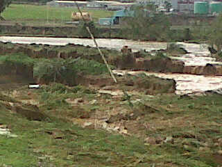
More news: on highway to the north both the choc and bois d'orange bridge are out, only back road access to north. Reprts of looting in castries (unconfirmed). Dennery village flooded, dennery hospital and school roof gone. Road between cacao and geneau is washed away, a number of houses lost in that slide. In cacao a landslide behind playing field claimed a number of house. Between morne citron (plateau) and la garre a big slide also, have not been there not sure of damage there. But God is good: we are still standing! Blessings
Frans / 758 7153129
- The day after...
By Michael Lascaris <mike_7800 at hotmail.com>
Date: Sun, 31 Oct 2010 15:35:15 +0000
Can't stay on for long, but just briefly...
We took a lashing last night..It's like the rain and wind would not stop.
Many roofs lost, landslides in many areas, electricity poles down, trees down, widespread flooding.
Island-wide electrical blackout.
Serious looting occurred during the storm.
All radio stations were out of service
Two bridges joining the City to the north of the island have collapsed.
Land lines are down.
Mobile phone service is flaky.
Gotta go now...
Mike
- Bad bad
By Frans Van Santbrink <j69ds at candw.lc>
Date: Sun, 31 Oct 2010 11:16:23 -0400
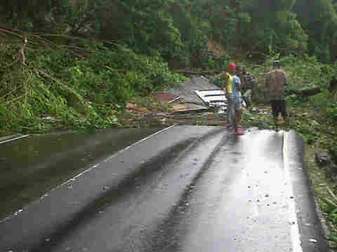
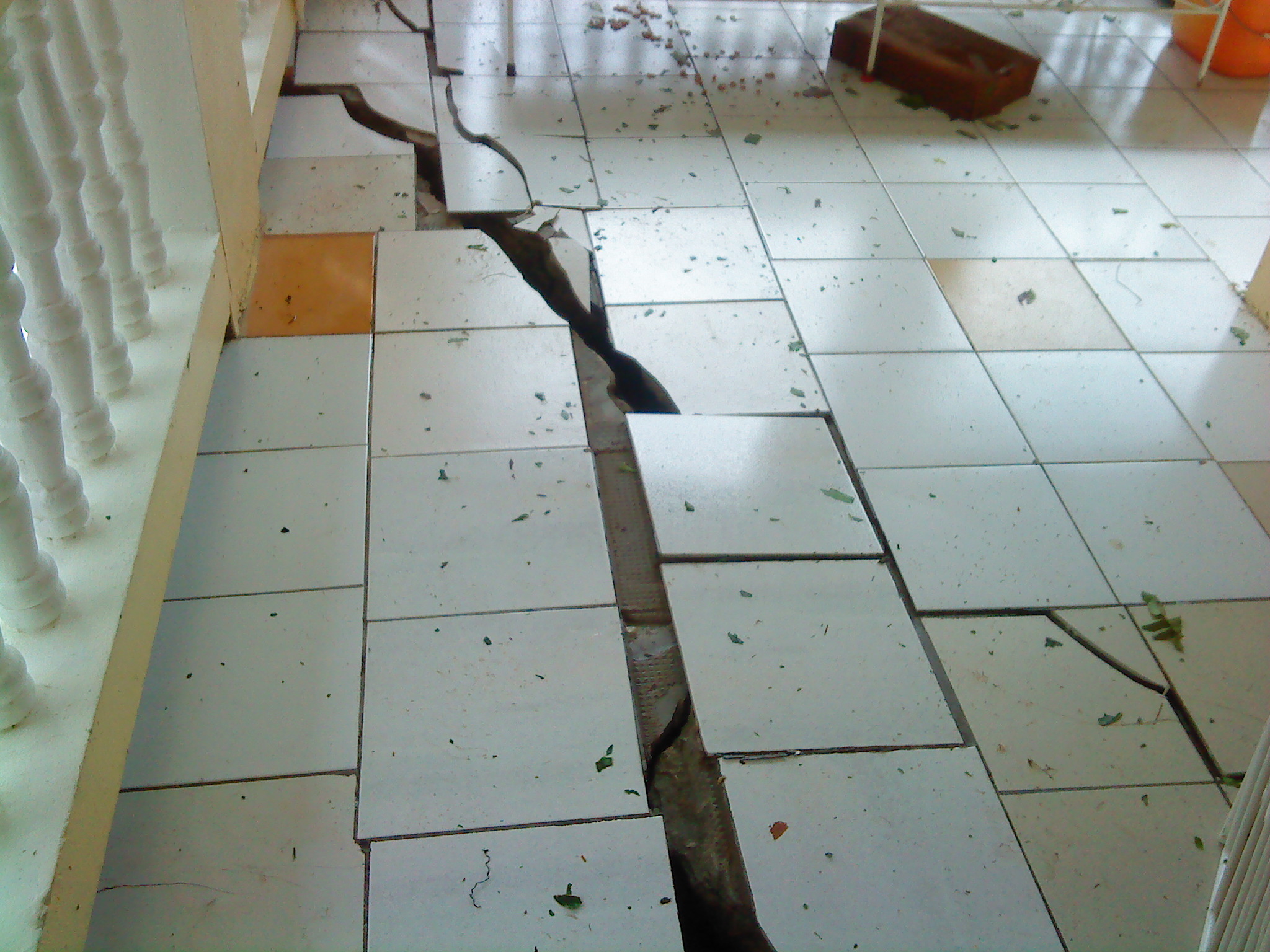
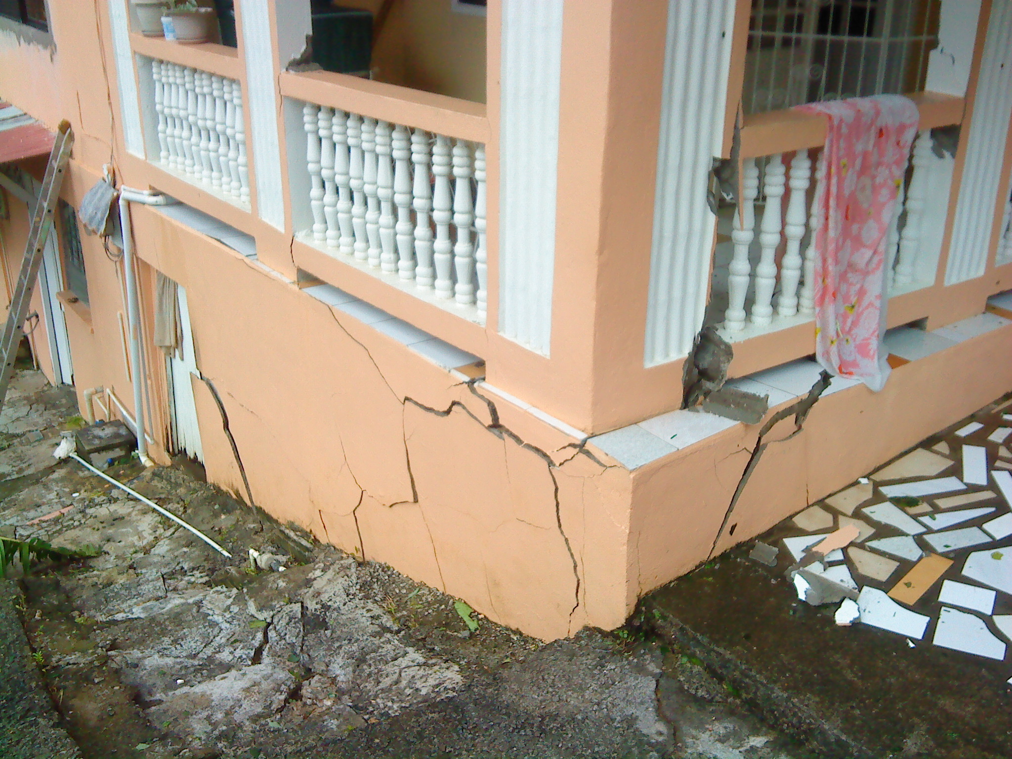
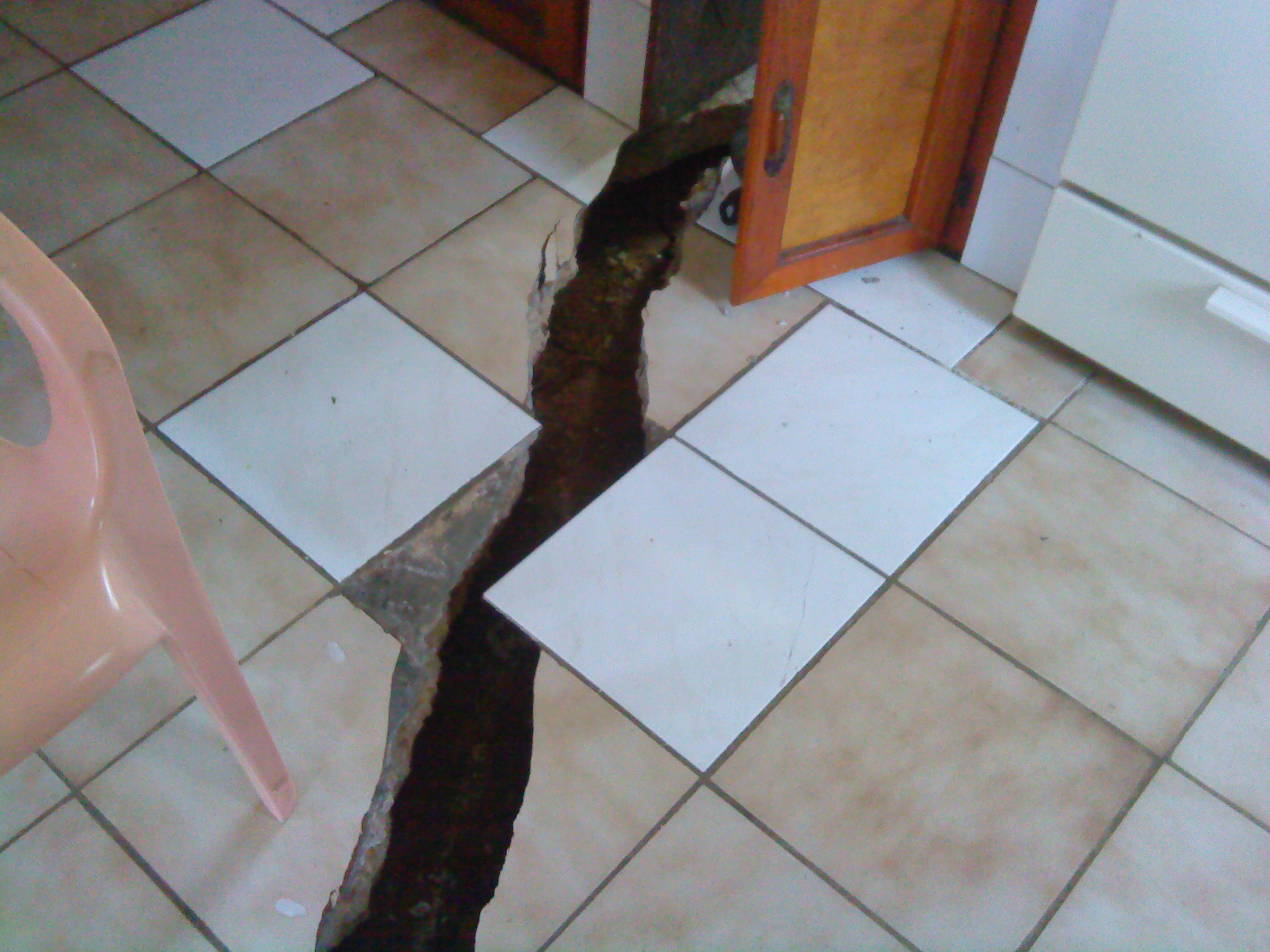
Just went to cacao and it is bad, landslides and roofs gone and trees down.. This is in the north I expect the south to be way worse. Heard there was a fatal accident yesterday in the morning, one dead others injured. Attached shots of house affected by slie in cacao... Not sure how long battery will hold out...
This is way worse than Dean (although for us up north it
was windier but I guess not for those in the south) and has much stronger winds
than we had with Debbie... So take those two and add them together and you have
Tomas!
I had to go back down to Castries at 5:30 pm, what a
nightmare that was. Managed to get some diesel from a friend but had to do it
in the pissing rain with howling wind gusts; not pleasant at all. The main
highway was still passable but there were a few areas where the water was
flowing swiftly across the road but not dangerous at that time. However it was
black like the inside of a cow and very difficult to see the edge of the road,
I kept questioning my sanity the entire way down...
So after filling up the tank it was time to head back....
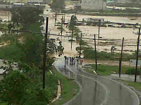
Jesus! Things were much worse and the road at Choc was almost impassable. I was
driving a SUV and it started drifting sideways and kept having to head into the
stream to get through. Very nasty and I was incredibly relieved to get through.
The worst to report is that the one and only bridge over
the Choc river is being undercut by the river. The Southbound lane has settled
at least 6" on that side and I would not be surprised if it collapses by
morning....
Without that vital bridge, traffic between the north and
south will have to go several miles inland and wind along a narrow and hilly secondary
road.... Oh Joy!!! :-(
Power is almost certainly out island wide and only those
of use with generators and businesses will have some semblance of normalcy
tonight. Thankfully Lime internet is still up and running! Getting power back
up will be a pain I am sure as there are a lot of trees and other debris over
the lines and I guess in the south there will be poles down as well. Did not
see any of that up here in the north.
Well thats it for not, I will check in tomorrow morning
if the net is working...
All the best,
Chris Kessell
- Update
By Frans Van Santbrink <j69ds at candw.lc>
Date: Sat, 30 Oct 2010 20:12:58 -0400
Rainy, windy and no power.. Wind is less but still gusting at gale force wind. Rain has not ceased at all. And no power so candle light for now. Many trees down, roads blocked/.. Cewn is back on 3.815 mhz lsb all through the night... Temp is nice n cool will sleep well... God bless
- Lesson learnt....
By mike_7800 at hotmail.com
Date: Sat, 30 Oct 2010 23:32:52 +0000
Tomas took us unexpectedly.....as careful and prepared as we always try to be,
I saw a tropical wave headed to us yesterday morning and dismissed it as a wet
weekend. By 5pm we were under a TS warning and by 8pm a Hurricane warning. The
day started out with some heavy gusts and minimal rain. By this afternoon we
had no power island wide, currently experiencing torrential rainfall, have
serious TS force winds for lengthy periods.

Property has been definitely lost, roofs, businesses, flooding, downed power
lines and poles, downed trees etc island wide.

The storm surge has apparently affected both airports and some hotels and
coastal dwellings.

All radio stations seem to be down.

May god guide us through the night, I believe we have, especially in the south
taken a serious pounding from this one.

Will report more as it comes.

Mike
Sent from my BlackBerry® BOLD.
- VB: Re:
By edgerestaurant at gmail.com
Date: Sat, 30 Oct 2010 18:44:32 -0500
----- Ursprungligt medd. -----
Från:edgerestaurant at gmail.com
Till:gert at vandijken.com
Ämne:Re:
The guys are up from the water and the wind has weakend and now blowing from E.
No power and we don t expect to get it back until things are calming down.
We had expected a really good halloween week end but that low out the window !
We do have 20 persons in the bar but it would have been more fun with 200
Some boats on drift and some stranded. The south of the island is badley damage
but Rodney Bay area is fine with a lotss of rain and only som gusts.
We will tryn to keep the restaurant open but qwe can not open the refrigerators
when we don t have any power. Bar only for now and most of the staff are
stranded in their homes.
Bobo
I can see :-)
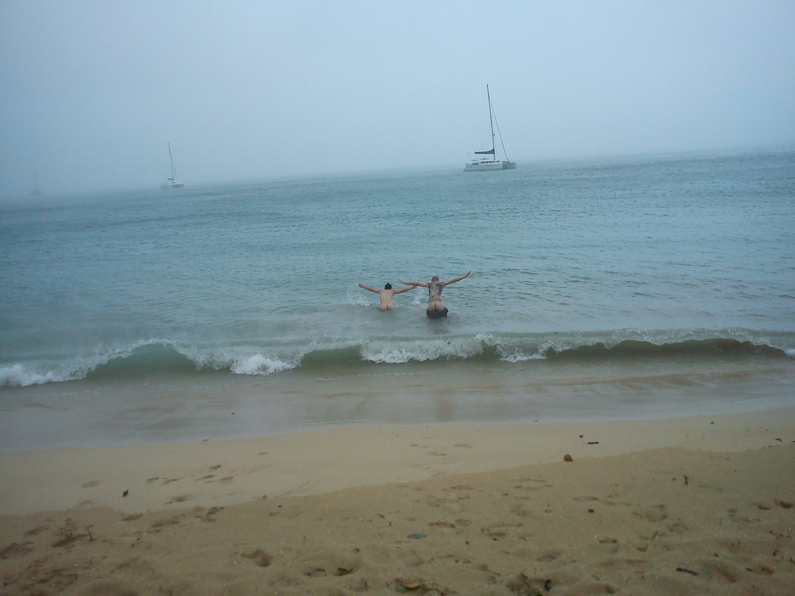
On Sat, Oct 30, 2010 at 1:49 PM, <edgerestaurant at gmail.com> wrote:
> Hurricane Tomas, Reduit beach, St lucia . Things are nice here on the beach
--
Gert van Dijken
Caribbean Hurricane Network
http://stormcarib.com
- VB:
By edgerestaurant at gmail.com
Date: Sat, 30 Oct 2010 18:43:53 -0500
----- Ursprungligt medd. -----
Från:edgerestaurant at gmail.com
Till:gert at vandijken.com
Ämne:

Hurricane Tomas, Reduit beach 15.49, St lucia . Things are nice here on the
beach, a bit windy, hurricane 1 after all and lots of rain
We're still getting strong winds from the north but this will change
soon and start to come from the south east - likely to bring more rain
than we've had up north so far and also to be stronger. I hope the
south and Vieux Fort are coping, they are in the jaws of Tomas. For
all of us, I hope this finishes soon before night comes. The sky has
cleared a little in the past 15 minutes and it is possible to see just
how rough the sea is to the north of the Pigeon Island causeway.
Chris Jenkins
www.zaravillas.com
www.facebook.com/zaravillas
- 1:30 pm in St. Lucia...
By "Christopher Kessell" <kessellc at candw.lc>
Date: Sat, 30 Oct 2010 13:43:02 -0400
Well, talk about being caught with our proverbial pants
down! Full on Panic mode this morning as everyone realized that there was a
Storm and most likely a hurricane making a bee line towards us!!
I'm in the North at Cap Estate and unlike Dean a couple
of years ago when we were the closest on the island to that hurricane, we are
being spared a bit by being now the furthest from the storm as it tracks South
of the island.
I had to drive down to Castries to help get a generator
running at a family owned business and of course there isn't enough diesel to
last the night... Can only hope that they restore power later tonight if the
conditions calm down. All businesses including gas stations are closed as of
mid morning at the latest.
The main highway between Castries and Rodney Bay was
still passable at 1:30 and as the rain has not been too torrential, hopefully
the drains and rivers will manage with the water and not flood the Choc and
Bois d'orange sections of the highway where flooding has closed the road in the
past.
Lots of smaller trees and endless branches are down along
all of the roads, there was a large coconut tree across the highway close to
the coast which was causing cars to have to swerve around into oncoming traffic
to avoid it. I shot some video of my drive up and will try and post it to
Youtube later.
Winds have not been too bad from Castries North, maybe
steady 35 at times with gusts to 50 mph I would estimate. If it stays like that
we should be able to ride it out quite easily.
I spoke to the boatyard manager at the IGY Marina and he
told me that things in the yard were fine with no threat to any of the boats at
that time.
I will report back later as the afternoon progresses...
All the best,
Chris Kessell
- Storm update
By "Louis Todor" <ltodor at candw.lc>
Date: Sat, 30 Oct 2010 13:43:15 -0400
30 oct 2010 13:30
Situation pretty stormy down here in Choiseul.
Power is down since around 10 am. I drove all the way to Vieux Fort to see
what's happening.
Trees are blocking the main road at some
places as much as 2/3 way but it is still possible to pass. Lot of rubbish on
the road everywhere, branches, pieces of signs etc.
The main road is blocked completely at True Value,
just before reaching Vieux Fort where 2 posts with power line are now
across the main road together with a part of a roof. It looks like no power for
a while.
I'm running on a generator, and will try to send
updates providing I still have internet access.
God Bless you all.
Louis Todor
- Update
By Frans Van Santbrink <j69ds at candw.lc>
Date: Sat, 30 Oct 2010 13:36:28 -0400
Power is out now, islandwide.. Wind is blowing due west now with gusts at about 60 to 70mph. In my yard most banana trees dow, my avocado tree uprooted, and many branches broken off. And been raining torrents since early o'clock
From a post on the Storm2k site...eye clearly visible east of St Vincent. Here in the North of St Lucia, winds are strengthening for sure and we would all be happy if it was suddenly 9pm.
Chris Jenkins
The eye is really firming up now
This is smaller than original. Click this bar to view the full image. The original is 720x480.
- same same
By "Frans van Santbrink" <j69ds at candw.lc>
Date: Sat, 30 Oct 2010 11:36:08 -0400
Winds still blowing pretty good and raining,here in north of Saint Lucia.
South is a different story from what I hear from my son who is in Choiseul (close to pitons). Down there loads of rain and wind is storming. Roofs blown off, no power where he is at, many power lines down. Hewanora Airport is flooded (sea rise). So it seems to be a mess down there.
Still got a ways to go here….
God Bless,
Frans van Santbrink
mobile: (758) 7153129 || VoIp: 347 298 0748
email: j69ds at candw.lc || fransjr at dageekz.com
Im: j69ds at hotmail.com
Skype: frans-jr
Radio : 146.940 (-0.600)
Web : Http://frans.dageekz.com
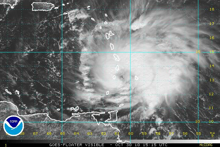
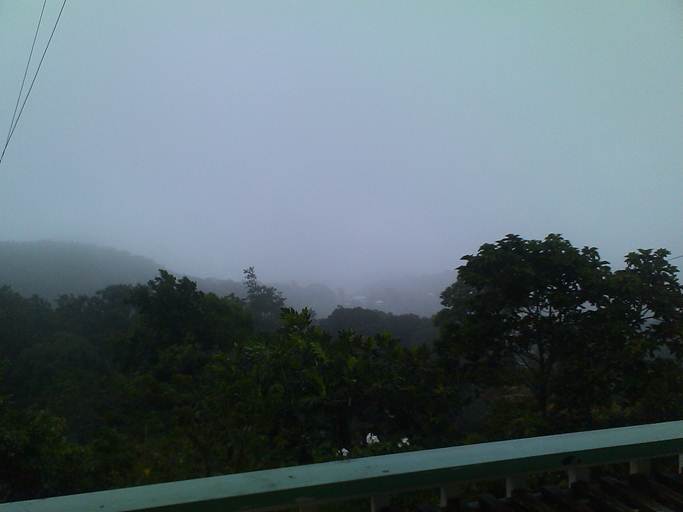
- more winds
By "Frans van Santbrink" <j69ds at candw.lc>
Date: Sat, 30 Oct 2010 09:43:44 -0400
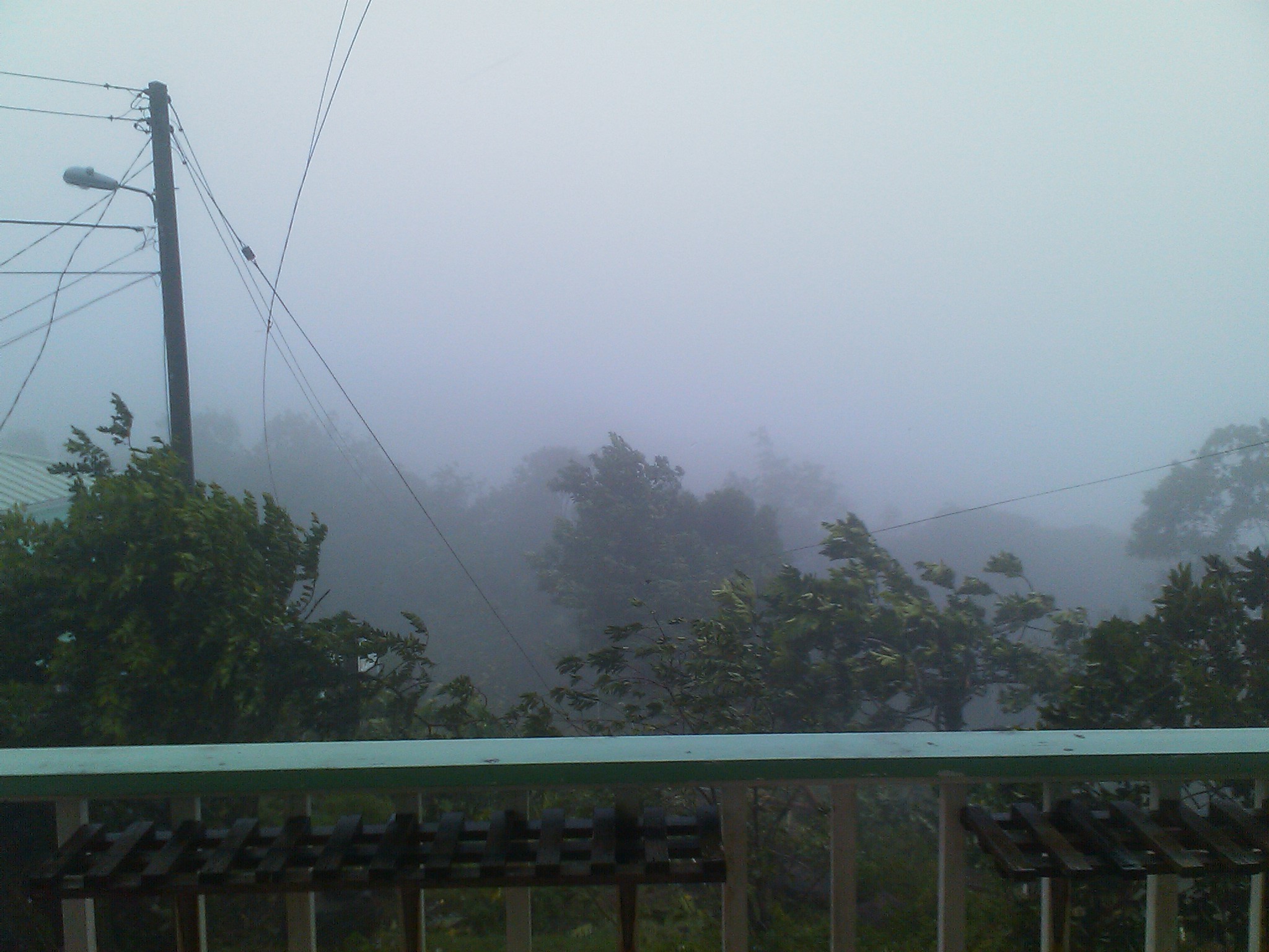
Winds are still increasing… up 50 miles gust here in Plateau (north of Saint Lucia).. Just heard some branches snap of trees across the road.
CEWN (caribbean Emergency and Weather Network) is now on 7.162 Mhz Lsb
Rain is coming down hard now for the past 45 minutes…
The view is gone.. looks like the rest of island is gone, J
View for balcony here
God Bless,
Frans van Santbrink
Radio : 146.940 (-0.600)
Web : Http://frans.dageekz.com
- windier
By "Frans van Santbrink" <j69ds at candw.lc>
Date: Sat, 30 Oct 2010 08:56:38 -0400
Wind is picking up here.. trees are blocking the barre de l’ilse already (reported by my son heading south)
Power lines down between Vieux Fort and Micoud, some roofs blown in Vieux Fort already.
Rivers are rising.
So long as we can get online we will post…
Greetz people
God Bless,
Frans van Santbrink
mobile: (758) 7153129 || VoIp: 347 298 0748
email: j69ds at candw.lc || fransjr at dageekz.com
Im: j69ds at hotmail.com
Skype: frans-jr
Radio : 146.940 (-0.600)
Web : Http://frans.dageekz.com
- Current situation
By The Edge Restaurant <edgerestaurant at gmail.com>
Date: Sat, 30 Oct 2010 08:43:58 -0400
We have had strong gusty winds with some rain during the whole night. Wind seem to be getting stronger gradually. The dogs and the cats knew already early last night what was going to come and has been inside since. At least one of the cat is usually out hunting during the night otherwise. The TV just went blue at the same time lights were blinking. I guess the TV station lost their power. So far we have power but the lights are blinking from time to time. We have not heard any thunder. Hope Barbados is not too bad.
CEWN (Caribbean Emergency and Weather Network) is active on 3.815Mhz Lower Sideband
Right now a good bit of rain and gale force winds at times here.. otherwise all is ok, storm shutters are up and stuff is inside…
Just hope the storm does not increase.
Hang in there ppl. St Vincent seems to directly in path right now
God Bless,
Frans van Santbrink
Radio : 146.940 (-0.600) // 3.815 Mhz Lsb
Web : Http://frans.dageekz.com
- Tomas
By Christopher Jenkins <chrissjuk at aol.com>
Date: Sat, 30 Oct 2010 06:40:15 -0400
As Mike has reported, the wind is up, the sideways rain is driving in
and we are some hours away before Tomas arrives for real. I was hoping
we would have been further North of the centre but the track has
shifted north and is only a few miles south of the forecast track I
posted a few days ago. Best wishes to all of us in St Vincent, St
Lucia and Martinique - we're like three very small sitting ducks out
here! Hope everyone in the Grenadines and Grenada is ok and the folks
in Barbados are safe as Tomas is over them now.
More later, as long as the power lasts.

Chris Jenkins
www.zaravillas.com
- Heating up.........
By Michael Lascaris <mike_7800 at hotmail.com>
Date: Sat, 30 Oct 2010 10:35:30 +0000
Tomas is now packing winds of 70mph as per the 5am advisory and the projected path puts the eye between SLU and SVG. TS (soon to be hurricane) conditions extend 140 miles from the center of Tomas, SLU is 28 miles long, so be preapred!!!! At the current speed, the eye will pass nearest to us near midday today and the storm should be in the caribbean sea later this evening into tonight.
RAINFALL...TOMAS IS EXPECTED TO PRODUCE TOTAL RAIN ACCUMULATIONS OF 3 TO 5 INCHES...WITH POSSIBLE ISOLATED MAXIMUM AMOUNTS OF 8 INCHES.
STORM SURGE...A DANGEROUS STORM SURGE WILL RAISE WATER LEVELS BY AS MUCH AS 1 TO 3 FEET ABOVE NORMAL TIDE LEVELS WITHIN AREAS OF ONSHORE FLOW. THE SURGE WILL BE ACCOMPANIED BY LARGE AND POTENTIALLY DESTRUCTIVE WAVES.
A hurricane warning is currently in effect for St.. Lucia.
A HURRICANE WARNING MEANS THAT HURRICANE CONDITIONS ARE EXPECTED SOMEWHERE WITHIN THE WARNING AREA...IN THIS CASE WITHIN 12 HOURS.
We're currently experiencing some strong showers and pretty gusty winds off and on, this is expected to increase over the next few hours.
Be careful, listen to bulletins, and may god watch over us, this is as real as it gets.
Mike
- tomas
By Christopher Jenkins <chrissjuk at aol.com>
Date: Fri, 29 Oct 2010 23:48:34 -0400
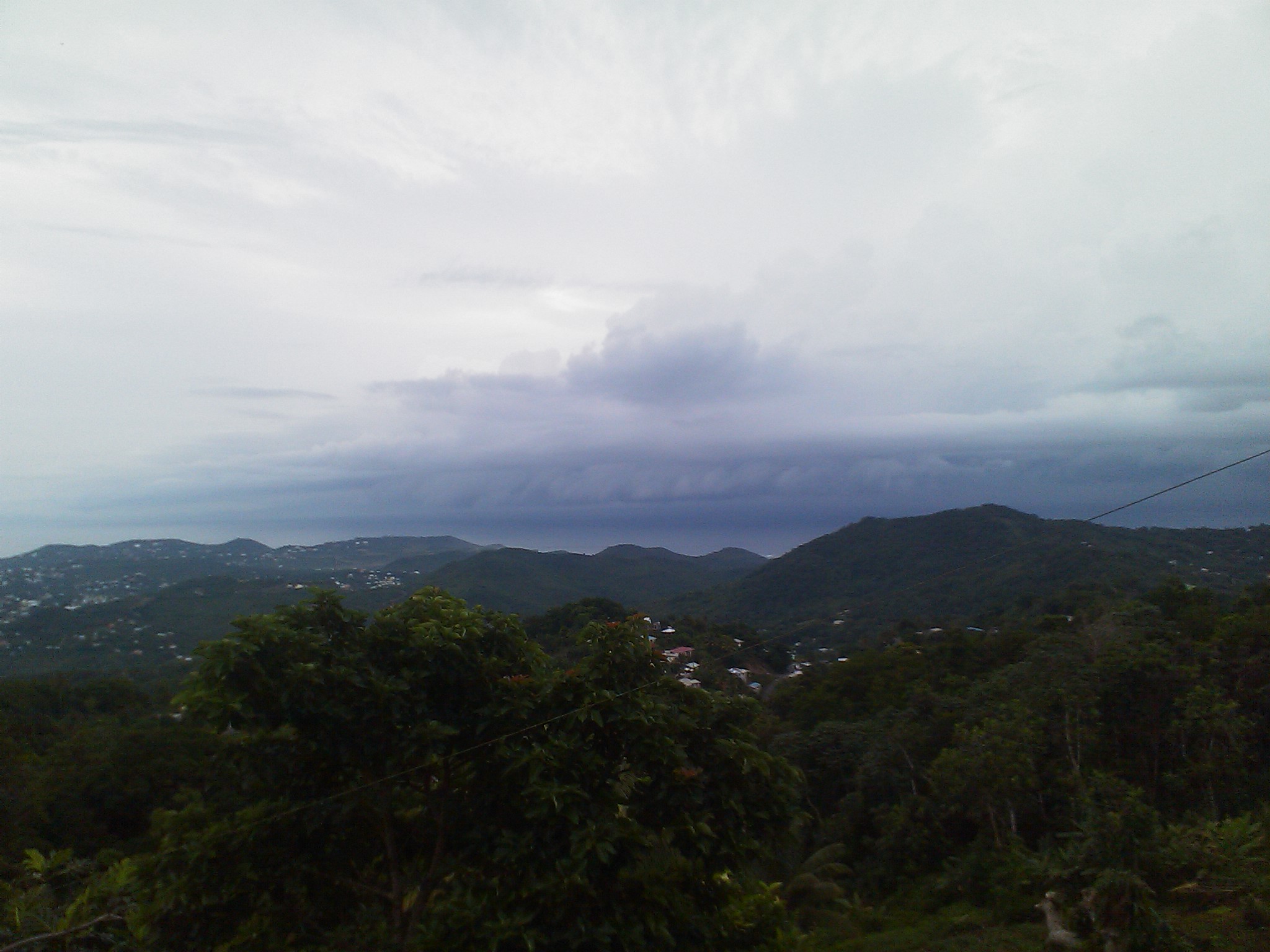
Well it is the weekend of Jounen Kweyol in St Lucia, one of the most popular events of the year, celebrating Creole culture. As Looshans love to party, and live in a country blessed with an exceptionally minimal record of severe weather, people are generally assuming they might have to celebrate in a bit of rain. There is little sense of people preparing for a storm, let alone a hurricane.
That the warnings for the country have emerged less than 24 hours before Tomas is due really does make one wonder why the NHC did not name this storm earlier. Anyway, tomorrow we will be on the northern periphery of a hurricane unless the forecasts continue to reflect the storm track is edging north, as has been the case for the past few hours. For Grenada, St Vincent and St Lucia and probably Barbados as well, the next 12 to 24 hours are going to be tough. We are already getting short sharp squalls but it is eerily like the calm before the storm
By The Edge Restaurant <edgerestaurant at gmail.com>
Date: Fri, 29 Oct 2010 23:29:32 -0400
As of 11 pm St Lucia is under a Hurricane Warning, which means that Hurricane conditions are expected somewhere within the warning area... in this case within 24 hours. An hour a so ago we had a short shower with strong winds but for now it is calm again. This one came on really quick and seem to intensify much faster than expected. All this in a time when we thought we were out of the woods already. I have just finished bringing in some lose stuff from the balcony. Waiting to see what the 2am update will bring.
Well St Lucia is overcast but calm and we will have some occasional,
seasonal showers today.
In terms of 91L the models seem to be converging on Grenada except the
Canadian version which tracks between here and Martinique. As the met
service in the French Islands is impacted by the same industrial
action as in France, it may be we receive less info than normal from
them.
Until the air recon is done later today, I doubt we will get much more
hard info from NHC so it remains guess work as to how wide an area the
system will cover as it passes over the weekend. Best be prepared as I
suspect many of us will get heavy rain even if we don't face the main
part of a storm. For now, I'm assuming the worst and hoping for the
best! To friends and family in Grenada and Barbados take great care
and speak to you soon.
Chris Jenkins
www.zaravillas.com
www.facebook.com/zaravillas
- heading this way
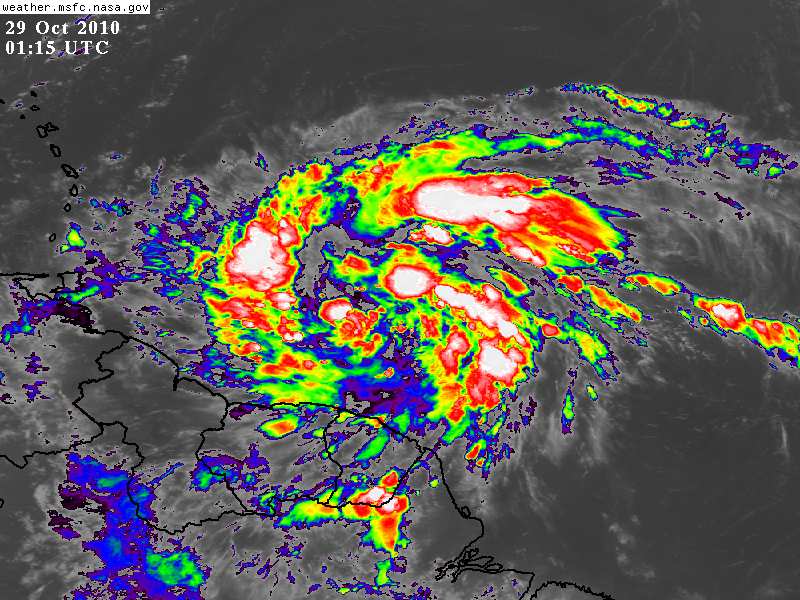
By Christopher Jenkins <chrissjuk at aol.com>
Date: Thu, 28 Oct 2010 23:31:46 -0400
This is a recent image of 91L - this is a huge system.
- Reasons to be serious...
By Christopher Jenkins <chrissjuk at aol.com>
Date: Thu, 28 Oct 2010 16:30:54 -0400
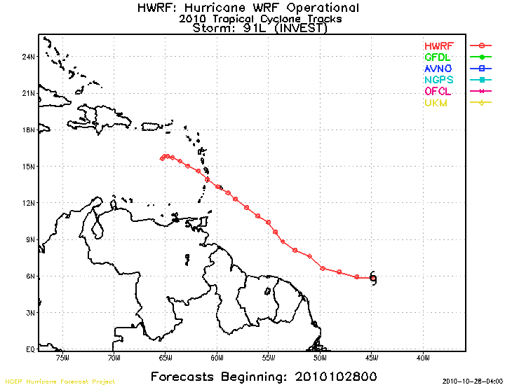
Hello St Lucians,
This is one of the forecast tracks for Invest 91L. As you'll see on
this model it runs right across us, possibly as a Tropical Storm with
60mph winds. If it follows this path, at it's current speed, it would
arrive here sometime on Saturday / Sunday
Chris Jenkins
- Invest 91L - again!
By Christopher Jenkins <chrissjuk at aol.com>
Date: Thu, 28 Oct 2010 14:27:47 -0400
Well if you're reading this page and the Grenada page you will be getting plenty of info on 91L. Hogan of Grenada has just reported the NHC has increased the chance of a tropical cyclone in 48 hours to 30%.
Forecast models predict a strong tropical storm by 48 hours, around the time 90L crosses the Windwards - somewhere between Martinique and Trinidad, know one knows just yet. That would be winds of potentially up to 60 mph.
Rob Lightbown of Crown Weather issued this on his web site this morning (I've also added his disclaimer):
"The HWRF model, however, is a little more believable as it forecasts a west-northwest track over the next couple of days and forecasts this system to track right over Barbados late Saturday as a tropical storm and then right over Martinique as a upper end tropical storm early Sunday morning. After that, the HWRF model forecasts this system to slow way down in the eastern Caribbean and intensify, so that by late Monday night it is forecast to be located near 16 North Latitude, 65 West Longitude as a Category 2 hurricane.
So, this is what I’m thinking this morning: I think Invest 91-L will track westward over the next 24 to 36 hours and then turn more to the west-northwest as it encounters a weakness in a ridge of high pressure. This should cause Invest 91-L to miss South America and instead track about halfway between Tabago and Barbados and then over St. Vincent during Saturday as perhaps a 50 to 60 mph tropical storm. After that, Invest 91-L is forecast to track into the eastern Caribbean late this weekend and then slowly track towards the central Caribbean early next week and be near 16 North Latitude, 69 West Longitude in 5 days from now or on Tuesday morning as a upper end Category 1 or low end Category 2 hurricane. After that, who knows as there is an equal chance of either this system being picked up by the East Coast trough or be left behind just south of Jamaica by later next week.
So, all interests in the Windward Islands, Trinidad, Tobago and Barbados should closely monitor the progress of this system as Invest 91-L may be on your doorstep in just 48 hours as a tropical storm. In addition, all interests in the Caribbean, especially those in Jamaica, eastern Cuba, Haiti and the Dominican Republic should keep close tabs on this system."
"Disclaimer: All forecasts herein are made to the best ability of the forecaster. However, due to standard forecasting error, these forecasts cannot be guaranteed. Any action or inaction taken by users of this forecast is the sole responsibility of that user."
St Vincent? Martinique? Er, what is in between those islands? Eh, eh, St Lucia!!
Just as November approaches and we could be forgiven for breathing a
sigh of relief that the Atlantic season was almost over and... three
blobs out in the Atlantic right now - two of which are shown tracking
to the UK!
91L is the one to watch for as it is big and described by the NHC as
"vigourous". No agreement on the track forecasts as yet - opinion is
split between Trinidad, St Vincent, St Lucia and Martinique - three of
those would put it pretty close to Barbados too. Whichever route it
takes, it is likely to catch some of us this weekend - it's 1000 miles
away and moving at around 20 miles an hour, 48 hours away.
Suggest Windward Islanders keep checking on this system and be
prepared. Check the track forecasts on StormCarib's homepage to see
the latest advice on where it is heading.
Please note, like most of us here, I'm only a weather watcher, and no
kind of meteorologist, so what I write here is simply opinion based on
information that is out there. Check your local Met Office and the NHC
for qualified advice!!
Right now St Lucia has sunshine and patchy cloud and a real nice breeze.

Chris Jenkins
www.zaravillas.com
www.facebook.com/zaravillas
- Another wave from Africa?
By Christopher Jenkins <chrissjuk at aol.com>
Date: Mon, 25 Oct 2010 08:57:30 -0400
Just in case people haven't seen this elsewhere, Crown Weather have on
Saturday and again today raised the potential for a wave coming
through the Windwards or further South via Trinidad, reaching the
Islands next weekend. The ECMWF forecast shows a track through
Leewards, Northern Windwards by Sunday and then moving on to PR and DR
in the following days. Let's hope conditions don't favour this but it
may be prudent, as Dave says, "to get the towels ready"!
Chris Jenkins
www.zaravillas.com
www.facebook.com/zaravillas
- Thoughts of others
By Christopher Jenkins <chrissjuk at aol.com>
Date: Fri, 22 Oct 2010 13:53:15 -0400
This hurricane season has a few weeks to go and may yet throw up some
last minute challenges. Invest 90 looks as if it is heading north west
and will not reach the Islands and the other blob, closer to us, is
thought to have little future. Richard is stalled out to the West and
countries in its path will have high rainfall. It may well survive and
recover but the jury is still out.
But we should all give some thought to the impact of Category 4
Cyclone Girl on Burma and the Super Typhoon Megi on the Philippines
and Taiwan - Megi dumped 45 inches of rain on Taiwan, which I really
struggle to imagine - nearly four feet of rain from a single storm!!!
St Lucia, is hot, humid and has had bands of rain and some gusty winds
over the past couple of days but no more severe weather and we've
enjoyed some really beautiful blue skied days over the past week and
fabulous evening skies and sunsets.
Haiti has not had any huge storms to face, which is just as well given
that visits and support from what seemed like half the world's
political figures, endless celebrities and intense media coverage can
still leave Haiti's homeless in plastic sheeted shacks and fail to
prevent cholera killing over a hundred people already.
Worrying about oneself and family is inevitable during the season as
storms cross the Atlantic but I always take encouragement from all
those people across the Caribbean who take time to think of others
when they face difficulties.
Chris Jenkins

www.zaravillas.com
www.facebook.com/zaravillas
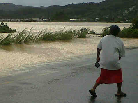
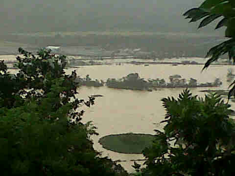
- Dennery declared a disaster area by the prime Minister of St. Lucia
Tuesday night and Wednesday morning there were tremendous thunder
storms, I've not heard thunder so loud. Strangely, here in the North
there was no rain that night after days of it, but on the East Coast
it was a different story. Eventually the local river broke its banks
and flooded the town of Dennery. Landslides closed the main road
through the country and the route to the international airport.
Here is a link to a locally shot video of Dennery high street after
the water receded enough to wade through it. Reports are the water was
up to five feet deep in peoples houses and the road outside.
No injuries reported so far, thankfully, but local people have lost
food crops, animals, vehicles and their belongings and for some, their
homes as well.
Chris Jenkins

www.zaravillas.com
www.facebook.com/zaravillas
- Southern Rains...
By Michael Lascaris <mike_7800 at hotmail.com>
Date: Wed, 6 Oct 2010 14:24:38 +0000
Reports of serious flooding, blocked roads and downed bridges from the south of St. Lucia this AM. Lightning and heavy thunder was seen and heard during the wee hours today, but no rain in the north.
- Sting in the tail...
By Christopher Jenkins <chrissjuk at aol.com>
Date: Tue, 5 Oct 2010 11:32:24 -0400
Torrential rain early this morning and again now and wind gusting from
the South / South East. Don't you just hate sideways rain?!
Sat images show 97L just about passing us by but this rain shows it
has a venomous sting in its tail. Hope it heads North East and out to
the Atlantic as soon as possible before it reaches DR and Haiti.
Stay dry friends

Chris Jenkins

www.zaravillas.com
www.facebook.com/zaravillas
- after rain is...
By "Frans van Santbrink" <j69ds at candw.lc>
Date: Tue, 5 Oct 2010 04:45:34 -0400
Hi all
After a very rainy Sunday afternoon and yesterday was the same. As far as I know it caused only some minor slides and some flash flooding in some areas. But nothing too serious.
Today it looks it will be a bit more sunny, the skies look clear for now.
25.2°C
Winds SSE 9 km/h
Relative Humidity 88%
Dew Point 26°C
Barometric Pressure 101
Pressure Tendency Steady
Visibility 16
Sunrise 5:53 AM
Sunset 5:50 PM
God Bless,
Frans van Santbrink
Radio : 146.940 (-0.600)
Web : Http://frans.dageekz.com
No virus found in this message.
Checked by AVG - www.avg.com
Version: 10.0.1120 / Virus Database: 422/3176 - Release Date: 10/04/10
- Invest 97L
By Christopher Jenkins <chrissjuk at aol.com>
Date: Mon, 4 Oct 2010 16:47:13 -0400
Thunderstorms, heavy rain overnight and gusty winds from the SE / ESE,
continuing into this morning. Little rain since mid morning here but
it is grey and gloomy - Martinique just about visible through the
cloud. More rain inevitable and we tend do cope with this amount of
rain better than St Vincent and Barbados (terrain not skill) and often
get less heavy weather than further North in the French Islands.
Basically, we just wish this damn weather would move on. Tedious, but
better than too exciting to cope with! I see more waves are heading
our way, so let's hope we get some break from the rain this month.
Chris Jenkins
www.zaravillas.com
www.facebook.com/zaravillas
- Waiting for the rain
By Christopher Jenkins <chrissjuk at aol.com>
Date: Sun, 3 Oct 2010 10:49:31 -0400
I thought this blob to the East was heading further North, until I
checked the Storm Carib page this morning and saw it right on our
shoulder.
Still can't see it but I can hear it now, thunder off to the East.
Suspect we're in for a wet afternoon.
Great video on the Barbados page of a rescue from an almost submerged
car (check the windscreen wipers near the end!)
Chris Jenkins

www.zaravillas.com
www.facebook.com/zaravillas
- still good
By "Frans van Santbrink" <j69ds at candw.lc>
Date: Wed, 29 Sep 2010 19:13:16 -0400
Hi All,
Sorry for not posting, got kinda sidetracked into all sorts of stuff.
But the weather here since Sunday has been sunny and hot with an occasional shower. Although out in the atlantic there are two possibles but so far those look to be more rain than anything else. Hope it stays that way .. J
God Bless,
Frans van Santbrink
Radio : 146.940 (-0.600)
Web : Http://frans.dageekz.com
No virus found in this message.
Checked by AVG - www.avg.com
Version: 10.0.1120 / Virus Database: 422/3166 - Release Date: 09/29/10
- Yellow blobs again
By Christopher Jenkins <chrissjuk at aol.com>
Date: Wed, 29 Sep 2010 17:12:46 -0400
Apologies all, my last message was obscured by a graphic which seems to have a mind of its own. I had written the following:
"Just on our doorstep is a yellow blob with another further east. The CIMMS Predict report shows Pouch PGI51L is the closest one, about six hundred miles east at 12N 56W, travelling at some 15 to 20 mph. Currently headed towards Martinique, the Northern windwards and Leewards are likely to receive some heavy rain by the weekend. The second blob is forecast to go to the North of the Leewards but even if neither becomes an Invest or Storm they are likely to produce rain and remind us we have some weeks to go before the season starts to wind down. The CIMMS link is worth bookmarking: http://cimss.ssec.wisc.edu/tropic2/predict/# "
Just on our doorstep is a yellow blob with another further east. The CIMMS Predict report shows Pouch PGI51L is the closest one, about six hundred miles east at 12N 56W, travelling at some 15 to 20 mph. Currently headed towards Martinique, the Northern windwards and Leewards are likely to receive some heavy rain by the weekend. The second blob is forecast to go to the North of the Leewards but even if neither becomes an Invest or Storm they are likely to produce rain and remind us we have some weeks to go before the season starts to wind down. The CIMMS link is worth bookmarking:
http://cimss.ssec.wisc.edu/tropic2/predict/#
After all the rain for a couple of days the sun was out yesterday in force. This morning it looks to become a hot day again.
A while ago we had a nice little morning shower and now the skies look to be set for a nice sunny day in paradise..
26°C PARTLY CLOUDY
RealFeel® 26°C
Winds NE 9 km/h
Relative Humidity 83%
Dew Point 23°C
Barometric Pressure 101.1
Pressure Tendency Rising
Visibility 16
Sunrise 5:53 AM
God Bless,
Frans van Santbrink
Radio : 146.940 (-0.600)
Web : Http://frans.dageekz.com
No virus found in this outgoing message.
Checked by AVG - www.avg.com
Version: 9.0.856 / Virus Database: 271.1.1/3154 - Release Date: 09/23/10
02:34:00
- still cloudy
By "Frans van Santbrink" <j69ds at candw.lc>
Date: Wed, 22 Sep 2010 06:36:01 -0400
Hi all,
Weather still cloudy here, not like yesterday which was like being in England all grey n stuff.
Look like we will have a few showers today but also some sun in between.
And on the map Lisa is still head further north so that is good and nothing else really other than a bunch of rainclouds.
Prediction by met office is light showers..
Temp 27°C
RealFeel® 30°C
Winds E 26 km/h
Relative Humidity 88%
Dew Point 25°C
Barometric Pressure 101.1
Pressure Tendency Rising
Visibility 16
Sunrise 5:52 AM
Sunset 6:00 PM
God Bless,
Frans van Santbrink
Radio : 146.940 (-0.600)
Web : Http://frans.dageekz.com
No virus found in this outgoing message.
Checked by AVG - www.avg.com
Version: 9.0.851 / Virus Database: 271.1.1/3149 - Release Date: 09/21/10
02:34:00
- Now Invest 95
By Christopher Jenkins <chrissjuk at aol.com>
Date: Tue, 21 Sep 2010 10:28:22 -0400
Well, following up my post of an hour or so ago, the "wave" has now become Invest 95L. Potentially a major hurricane in a weeks time over to the west.
Chris Jenkins
- Tropical Wave over the Windwards
By Christopher Jenkins <chrissjuk at aol.com>
Date: Tue, 21 Sep 2010 09:08:43 -0400
Most of the Windwards are sitting under a tropical wave that has been
raining on St Lucia since early yesterday afternoon. We're getting
occasional squalls now and right now the wind is whipping up
outside. This will take some time to pass over us yet. This is
possibly Invest 95 in the not too distant future. This front has been
monitored for a week now with it being forecast to be a major system
in the Caribbean in a few days to a weeks time but there is no
agreement or consensus as to where it will head or land. I keep hoping
the Cape Verde season is coming to a close but this is on target to be
a very busy year and we have some weeks to go perhaps before we can
take our eyes off the African coast line. Good luck to everyone in
Bermuda during their clean up.
Chris Jenkins
www.facebook.com/zaravillas
- rains
By "Frans van Santbrink" <j69ds at candw.lc>
Date: Tue, 21 Sep 2010 05:14:52 -0400
Hi All,
Still raining here, been like this all night. Temp dropped nicely feels great for a change.
I see next storm has formed (Lisa) but it looks to not be a problem for us here, although one never knows really…
Just keep an eye on it!
Temp 25°C
RealFeel® 24°C
Winds E 24 km/h
Relative Humidity 94%
Dew Point 24°C
Barometric Pressure 101
Pressure Tendency Unavailable
Visibility 16
Sunrise 5:52 AM
Sunset 6:00 PM
God Bless,
Frans van Santbrink
Web : Http://frans.dageekz.com
No virus found in this outgoing message.
Checked by AVG - www.avg.com
Version: 9.0.851 / Virus Database: 271.1.1/3147 - Release Date: 09/20/10
02:35:00
- wet again
By "Frans van Santbrink" <j69ds at candw.lc>
Date: Mon, 20 Sep 2010 18:06:56 -0400
Hi All,
Since around midday today some well deserved rain started falling… it has been too dry really for this time of the year.
Thankfull that all the bad ones go north, but still a bit of rain is good…
So right now we are in the clouds on top of the mountain and it is still raining, and looking to continue for a bit…
The garden and vegetables are happy again!
26°C
RealFeel® 31°C
Winds NE 20 km/h
Relative Humidity 94%
Dew Point 25°C
Barometric Pressure 101
Pressure Tendency Steady
Visibility 16
Sunrise 5:52 AM
Sunset 6:01 PM
God Bless,
Frans van Santbrink
mobile: (758) 7153129 || VoIp: 347 298 0748
email: j69ds at candw.lc || fransjr at dageekz.com
Im: j69ds at hotmail.com
Skype: frans-jr
Radio : 146.940 (-0.600)
Web : Http://frans.dageekz.com
No virus found in this outgoing message.
Checked by AVG - www.avg.com
Version: 9.0.851 / Virus Database: 271.1.1/3147 - Release Date: 09/20/10
02:35:00
- Even here, we can feel and see Igor's effect
By Christopher Jenkins <chrissjuk at aol.com>
Date: Wed, 15 Sep 2010 18:42:48 -0400
Another baking hot day in St Lucia with very little breeze but as the
sun sets, a fresh breeze has picked up from the west and is sending
bands of rain cloud inland along the western coast line. Clear to the
East, but some rough sees according to the St Lucia met office and out
in the Caribbean strong waves are clear to see, the surf rolling into
the coast line up here in the North of the Island. The Met Office has
issued a local small craft warning today for both the Caribbean and
Atlantic sides as a consequence of Igor.
Now, we have to wait and see what else the month brings from the
African coast and there are two areas of activity being monitored
either or both of which could come in the direction of the Windwards,
low riders currently at 8N but still way out East. This is turning
into the bumper season that was forecast and with 2 Cat 4 hurricanes
in the Atlantic and a Tropical Storm to the West, it certainly isn't
quiet any longer. Right now, spare a thought for Bermuda as the models
show Igor tracking over or very close to them.
Take care one and all

Chris Jenkins

www.facebook.com/zaravillas
- Hot September days & nights
By Michael Lascaris <mike_7800 at hotmail.com>
Date: Wed, 15 Sep 2010 12:55:52 +0000
Yesterday and last night were blazing, thanks to Igor and company. Today looks like it will be the same. Got some good swells, boats had to to be moved from Gantes Bay and saw signs that the sea was on the road at Penninsula Road, Vigie this AM.
God Bless.
Mike
- drying up
By "Frans van Santbrink" <j69ds at candw.lc>
Date: Wed, 15 Sep 2010 05:33:54 -0400
Hi All,
It has been a hot night, Igor is sucking us dry J and Julia following soon after looks like no respite from this heat.
Better them hurricanes keep going north instead of the alternative.
Yesterday was a scorcher and today looking to be another one too.
Weather stats:
23°C 5:15 AM
RealFeel® 28°C
Winds Calm
Relative Humidity 94%
Dew Point 22°C
Barometric Pressure 101
Pressure Tendency Steady
Visibility 16
Sunrise 5:52 AM
Sunset 6:05 PM
God Bless,
Frans van Santbrink
mobile: (758) 7153129 || VoIp: 347 298 0748
email: j69ds at candw.lc || fransjr at dageekz.com
Im: j69ds at hotmail.com
Skype: frans-jr
Radio : 146.940 (-0.600)
Web : Http://frans.dageekz.com
No virus found in this outgoing message.
Checked by AVG - www.avg.com
Version: 9.0.851 / Virus Database: 271.1.1/3135 - Release Date: 09/14/10
14:34:00
- DTA
By Michael Lascaris <mike_7800 at hotmail.com>
Date: Tue, 14 Sep 2010 13:57:26 +0000
DTA = Don't Trust Anything....Keep your eyes on the forecasts people, hope for the best but PREPARE the worst...Igor's direction has moved northwards by 15 degrees, but the computer models have been proven wrong before, so let's watch out..
Mike
- tuesday...
By "Frans van Santbrink" <j69ds at candw.lc>
Date: Tue, 14 Sep 2010 05:22:46 -0400
Hi all,
Yesterday was a beautiful day, and this morning the skies are clear again and looking for another hot day in paradise.
The view since last night of Martinique is spectacular, beautiful to see all the lights sparkling in the distance across the channel.
On the weather map two hurricanes both predicted to head north into the North Atlantic, Igor and Julie both look to be no threat to us here.
Weather stats:
23°C 5:15 AM
Winds Calm
Relative Humidity 94%
Dew Point 22°C
Barometric Pressure 101.1
Pressure Tendency Rising
Visibility 16
Sunrise 5:52 AM
Sunset 6:06 PM
God Bless,
Frans van Santbrink
Radio : 146.940 (-0.600)
Web : Http://frans.dageekz.com
No virus found in this outgoing message.
Checked by AVG - www.avg.com
Version: 9.0.851 / Virus Database: 271.1.1/3133 - Release Date: 09/13/10
14:35:00
- nice weather
By "Frans van Santbrink" <j69ds at candw.lc>
Date: Sun, 12 Sep 2010 06:54:59 -0400
Hi All,
Today is starting out as a beautifull day: sunny and clear skies with a nice little breeze here, and with nothing threatening our little island it feels great..
Only thing that bears watching in the days to come is the next blob of clouds coming of the African coast.
27.5°C 6:53 AM
Winds ESE 28 km/h
Relative Humidity 78%
Dew Point 25°C
Barometric Pressure 101.1
Pressure Tendency Rising
Visibility 16
Sunrise 5:52 AM
Sunset 6:07 PM
Gal 2:20
I have been crucified with Christ; it is no longer I who live, but Christ lives in me; and the life which I now live in the flesh I live by faith in the Son of God, who loved me and gave Himself for me.
God Bless,
Frans van Santbrink
Radio : 146.940 (-0.600)
Web : Http://frans.dageekz.com
No virus found in this outgoing message.
Checked by AVG - www.avg.com
Version: 9.0.851 / Virus Database: 271.1.1/3129 - Release Date: 09/11/10
14:34:00
- late post today
By "Frans van Santbrink" <j69ds at candw.lc>
Date: Fri, 10 Sep 2010 17:52:26 -0400
Hi all,
This morning woke up to grey gery weather, it started during the night, rain thunder and lightening.
It has been grey and dreary weather all day, although only early morning around 7 did we have a downpour in town the rest of the day was just very grey and covered but dry.
And it looks like it will stay that way for the night according to the weather image, and the only system out there is Igor and he is looking to head North so no direct treat to us here.
Hope tomorrow is a bit sunnier, and at least dry in the early hours since on Saturday we do our prayer walk by the beach.
God Bless,
Frans van Santbrink
Radio : 146.940 (-0.600)
Web : Http://frans.dageekz.com
No virus found in this outgoing message.
Checked by AVG - www.avg.com
Version: 9.0.851 / Virus Database: 271.1.1/3126 - Release Date: 09/10/10
03:08:00
- 92L Invest
By The Edge Restaurant <edgerestaurant at gmail.com>
Date: Fri, 10 Sep 2010 08:27:48 -0400
Hi all
We have a low pressure system, 92L invest, in our neighbourhood but so far the weather has not been so bad at least not here in the north of St Lucia. Yesterday afternoon, during the night and this morning we have had some showers and also some thunder rumbling in the distance yesterday afternoon, no wind. I think it looks worse on the satellite pictures than in reality, but we will see what the day brings.
Right now it is overcast but no rain and no wind.
Annika
Please be advised that The Edge Restaurant Bar & Sushi will be closed for it's annual vacation from August 30, 2010 to September 30, 2010. We look forward to see you again from Friday October 1, 2010!
Clear overnight. At dawn in the north of St Lucia, clear views to Martinique and the Pitons from here but I'm told there very heavy rain has been moving along the East Coast NW along the Island and now heavy rain clouds moving into us from SSE / SE. Can still see Martinique but the hills to the south of us are covered in cloud and the rain is visible. Breeze picking up, mainly from SE but seems to be switching back and to, ESE. Trinidad reporting storms and winds of 30 mph plus. I wondered when this would arrive and it looks as if it will do so imminently, but we are only just within its northern edge and it seems more to be moving more westerly than I had guessed. Puerto Rico bound or further south? Hopefully the Leewards will get a break this time. To Gail in Grenada, hope you're ok and the house is water tight!
- humpday
By "Frans van Santbrink" <FransJr at dageekz.com>
Date: Wed, 8 Sep 2010 05:43:08 -0400
Hi All,
And here we go again two waves leaving Africa, but I think both are too far North for us (although one never knows eh)
Right now we are in the clouds here on top of the mountain, it is grey all around (although sat image show nada there) with a light drizzle…
I think it will clear up in a little while and make for another sunny day…. So I think eh.
But so far so good with this season….
God Bless,
Frans van Santbrink
Web : Http://frans.dageekz.com
Twitter: FransJr
- so hot today
By "Frans van Santbrink" <FransJr at dageekz.com>
Date: Tue, 7 Sep 2010 06:07:30 -0400
Hi all,
Early rise this morning, it is so hot during the night even… I guess is the effect of the system just north of us, temp is already 29 celcius!
Just yesterday the Atlantic was clear, now there are three possibilities on the map two of which are too far north already, the third a maybe…
But for today looks like another scorcher indeed, the birds are singing outside and skies are clear.
Have a blessed day my friends,
B Marley (Three Little Birds):
Rise up this mornin'; smiled with the risin' sun.
Three little birds pitch by my doorstep
Singin' sweet songs of melodies pure and true; saying,
"This is my message to you-ou-ou.”
Singin': "Don't worry about a thing, ‘cause ev-ry little thing gonna be all right."
Sayin': "Don't worry about a thing, ‘cause ev-ry little thing gonna be all right!"
God Bless,
Frans van Santbrink /.
Web : Http://frans.dageekz.com
- Sunday sunday
By "Frans van Santbrink" <FransJr at dageekz.com>
Date: Sun, 5 Sep 2010 06:19:41 -0400
Hi All,
Good morning to all on this beautiful Sunday.
WX here this morning is very sunny, just a few puff clouds above and way out in the distance a few small grey ones. Today the haze has lessened to where we can see Martinique again.
With nothing threatening out in the Atlantic right now, it makes for a great and of course hot hot hot Sunday.
Time to go get ready for worship of our Lord Jesus!
Wishing everybody a blessed sunday
God Bless,
Frans van Santbrink
Web : Http://frans.dageekz.com
- Hello Weekend
By "Frans van Santbrink" <FransJr at dageekz.com>
Date: Sat, 4 Sep 2010 06:20:21 -0400
Hi All,
Woke up this morning to a nice sunny morning.. no morning shower and I did not notice any nightly rains either…
A few clouds in the sky and it is still hazy, can hardly see Martinique today. But it looks to be another sunny day in paradise.
The mess left by Gaston still trying to form but is already too far North for us and the blob on the other side of the Atlantic can’t seem to make up its mind which is good…
Attached a photo of flower in the garden this morning, this flower starts out white and then turns pink..
Time to turn on the radios to check in to the CEWN on 3.815 Lsb.
TGIF in paradise, birds are chirping and a few clouds in the skies…looks like it is set to be a hot day again with maybe an early morning shower…...
We had a few showers overnight, just enough to wet the ground a bit, on top of this mountain.
Gaston has been downgraded to just a mess in the Atlantic, with a 20% chance of formation, so that is good, hope it stays that way too. We just got to keep our eyes on the blob now leaving Africa however.
Turning on the radios so I can check into the Emergency and Weather Net on 3.815Mhz Lsb (daily 6:30 am & pm daily)
The season is really kicking into gear with storm after storm making its way across the great blue… but so far so good.
I just hope they keep turning far north and miss us all, we won’t miss them I am sure LOL
We got our eyes on the one out in the Atlantic (a 50% chance of cyclone dev) and making sure we are as ready as can be; canned foods, water materials etc etc..
It has been so long since we got hit by a big one that it is likely to happen anytime now L
Anyways have a blessed day everybody,
God Bless,
Frans van Santbrink
- Earl
By The Edge Restaurant <edgerestaurant at gmail.com>
Date: Sat, 28 Aug 2010 08:52:24 -0400
Hi all
I certainly agree with Chris before me. It looks like Earl has difficulty to make up his mind, wobbling back and forth. His latest dip to the southwest made me concerned as it looked like he was racing just towards us. Earl is still 800 miles out from our islands and everyone certainly hope for a quick turn to the north. If not quick enough, be prepared and stay safe up in the north and for us further south lets make sure we have our things in place for what might be on our door step any time soon.
Annika
Please be advised that The Edge Restaurant Bar & Sushi will be closed for it's annual vacation from August 30, 2010 to September 30, 2010. We look forward to see you again from Friday October 1, 2010!
Despite all model forecasts of earlier this week, Earl is still
winging his way due west and it seems unlikely he will gain latitude
until 60W so the track is ever closer to the Leewards and maybe here
in St Lucia we will fall within the cone. Was hoping to have watched
Earl curve away to the North some time ago. As he's carried on West,
time to think of Fiona and Gaston which seem likely be coming this way
from Africa sometime soon. I suspect St Lucia will be on the edge of
whatever Earl has to offer us so maybe we will have time to prepare
for the next storm. For now, thoughts are with all of those in the
Leewards and prayers are for a recurve north SOON!
Chris Jenkins
www.zaravillas.com
- Time to get ready...
By Christopher Jenkins <chrissjuk at aol.com>
Date: Sun, 15 Aug 2010 18:39:30 -0400
Well, things have been quiet so far but it does look as if there is every reason to check on how ready we are for severe weather in the coming days. Crown Weather posted this today:
Eastern Atlantic Development This Week Through Next Week With Up To Two To Three Named Storms Possible: Looking at the long range prospects. If the model guidance is to be believed, we are looking at a very busy 10 to 15 days across the Atlantic Basin with up to 3 additional tropical cyclones forecast. The latest GFS model is forecasting the following: A major hurricane to track out into the open Atlantic in about 8 to 10 days. A second major hurricane to impact the northern Leeward Islands around August 27th and then impact the Bahamas and threaten Florida around August 30th. The GFS model is also forecasting a third tropical cyclone to form around August 25th and impact the Windward Islands and Barbados around August 30th.
The last time Barbados was hit by a Hurricane was in 1995, but in 1960, 1963 and in 1980 it was hit by Hurricanes that then intensified and went on to hit St Lucia - Allen in 1980 was a Cat 3 over Barbados and a Cat 4, 132 mph winds, over St Lucia, the worst storm here for over 150 years.
Crown is not alone in forecasting this surge in activity in the last week of August, even if the models are far from clear as to storm path as yet. Don't leave it to fate, get ready now, better safe than sorry and I hope you can all complain about us being alarmist when these storms curve out into the Atlantic (Yes, Please!!!)
Heavy rains from a series of tropical waves, including Invests 92 and
93, have produced a week of heavy rain and today we're seeing local
flooding in the north of St Lucia. Drainage systems are not coping
well with the sheer volume of water. The highway between Gros Islet
and Pigeon Island is under water and people are pumping out their
drains which cannot cope - but right now it's difficult to work out
where to pump any water to as every where is saturated.
With the next wave due in a couple of days time, I'm certain that we
will see landslips here as the soil in places cannot absorb the volume
of water. Looking at the current satellite images, we seem to be
getting weather from all directions, hence my confusion as we see
clouds heading east and south east over the Eastern Caribbean as well
as west and north west.
Here at Zara Villas, this is the first rainy season since people moved
in so it is a "learning experience" watching exactly where the water
is coming from and going to. And it is only two months since the
drought restrictions were lifted - ain't the tropics wonderful!
Good luck to all, especially those getting the full brunt of Invest 93.

Chris Jenkins
www.zaravillas.com
- Tropical Wave passing through
By Christopher Jenkins <chrissjuk at aol.com>
Date: Wed, 9 Jun 2010 11:46:49 -0400
Hello to all weather watchers out there. Dire forecasts for this
season and I can only hope enough resources reach Haiti to prevent
further disaster, the rain alone threatens many lives. As a tropical
wave passes through here with winds currently around 30kph, it was
time to carry out an initial check of whether our site clear up had
left any loose materials around. So far so good, but I can see
downpipes from the roof terraces that need better clipping before they
sail away. Winds tonight forecast to increase to around 40kph and the
rest of the week will be pretty windy. I read Jeff Master's blog today
and he is suggesting La Nina will bring us additional rainfall this
year in the region, as if the Hurricane forecast wasn't enough! So, as
Gert always reminds us, prepare now - it's looks like being one heck
of a season
Regards to all
Chris Jenkins
www.zaravillas.com
- Wow..
By Michael Lascaris <mike_7800 at hotmail.com>
Date: Wed, 2 Jun 2010 15:03:47 +0000
We were awoken in the wee hours yesterday morning by the barking of the dogs outside to the pleasantries of A LOT of rain. More than I've seen in the past year in SLU, and accompanied by lightning and thunder. After the drought earlier this year, rain is always welcome.. The season is on, be prepared, it doesn't have to be wind to cause major damage.
Hotmail: Free, trusted and rich email service. Get it now.
- (no subject)
By SWhite3726 at aol.com
Date: Wed, 12 May 2010 10:40:22 EDT
So an up to date weather report, hmmmmmmmmmm let me see, oh yes
Rain
COLD
Cloud
COLD
Windy
COLD
Sunny
Warm
Cloud
COLD
And that's just in the last 36 hours, but of course I am in the UK!
Looking forward to heading back to St Lucia to warm up and of course my rum on
the beach ...................
- (no subject)
By SWhite3726 at aol.com
Date: Fri, 7 May 2010 15:00:57 EDT
Well, what can I say, St Lucia is still having beautiful breezes, lovely
sunshine and gorgeous blue seas, what more can you want!
I hope it stays that way for a couple of weeks as I am off on my hols so I
wont be here to keep everyone informed for a bit. I know, life is just one
big holiday here in St Lucia but I am off to see my family and very much looking
forward to catching up and seeing friends as well. The weather will seem
soooooooooo cold after here though, so will pack my thermals!
Everyone be safe out there, see you all in a few weeks.
- (no subject)
By SWhite3726 at aol.com
Date: Mon, 3 May 2010 06:59:18 EDT
A very good morning to everyone around the world. The weather here is
getting back to a very predictable, very dry and very hot time of year.
There have been no showers to speak of for a good few weeks now and things are
starting to get parched again.
The winds have been strong and gusty the last few days and they still are
today, but I dont see any clouds on the horizon so its not likely that any rain
is heading our way, so I guess I shall just have to get the hosepipe out
today!
I did at least finally get all my new trees and shrubs planted, it took a
while as I had a good selection to get in. I now get to sit back and
hopefully reap the rewards - and the crops of course!
Thought for the Week
Accept that some days you are the pigeon and some
days the statue.
- (no subject)
By SWhite3726 at aol.com
Date: Sat, 1 May 2010 12:45:50 EDT
So another new month, May is here, how come the time goes by so fast in the
Caribbean. I moved here for a slow and relaxing pace of life but somehow
the days go by even faster!
The weather here has settled into yet another dry spell, hardly any rain
for a good while now, an odd shower during the night but that is about it.
A good brisk wind, plenty of sunshine and hot temperatures, perfect for a rum on
the beach!
We have some lovely guests in our rental house right now from the States,
it really is the perk of the job meeting lots of new people and swapping life
experiences. They are enjoying all our beautiful island has to offer,
today they are off diving at Anse Le Raye which is a stunning beach and it has
plenty more for them to discover under the sea.
Dont forget to check out my website if you fancy visiting!
