|
For the most recent reports from Jamaica see this page.
|
- FLASH FLOOD WATCH NOW IN EFFECT FOR ALL PARISHES
|
- By "Blayz" <blayzbrooks at hotmail.com>
- Date: Sat, 9 Oct 2010 12:35:10 -0500
|
***
FLASH FLOOD WATCH NOW IN EFFECT
FOR ALL PARISHES ***
The Meteorological Service has issued a Flash
Flood Watch for low lying and flood prone
areas of all parishes effective until 5:00 p.m.
tomorrow.
A FLASH FLOOD WATCH
means flooding is possible and citizens are advised to take
precautionary measures, keep informed by listening to further News Releases from the Meteorological
Service and be ready for quick action if flooding is observed or if a warning is
issued.
An Area of Low Pressure is
currently generating unstable weather over the Central Caribbean especially off
the south coast of Jamaica.
This disturbance is expected to linger across the region until Monday and will
influence the weather over Jamaica during the period.
Satellite Imagery and radar reports indicate a large
area of moderate to heavy showers with embedded thunderstorms south of Jamaica,
moving northward.
The forecast is for outbreaks of
moderate to heavy showers and thunderstorms to affect the island this afternoon
through tonight and Sunday. As a result, Flash Flood is possible.
Fishers and other marine
interests are advised to exercise caution especially over southern waters.
The Meteorological Service will continue to monitor the progress of
this system.
|
Consul General Appeals To Canadians For
Assistance
|
TORONTO (JIS)
Wednesday, October 06,
2010
|
Jamaica's Consul General in Toronto, Seth
George Ramocan, has appealed to Canadians for support, in the aftermath of the
extensive damage to the island's infrastructure caused by Tropical Storm Nicole
last week.
"One of the issues we face is that, because
this was not a hurricane, (is that) we are not allowed to tap into international
agencies for assistance, but the damage done is of hurricane proportions," Mr.
Ramocan stated.
He was speaking at a Media Conference at the
Jamaican Consulate General in Toronto, Canada, on Tuesday (October 5), providing
an update on the situation in Jamaica. He showed members of the media
photographs of the damage left by the storm.
"So far, the estimated damage stands at about
J$14 billion, although damage assessments are still being conducted by various
ministries and agencies," Mr. Ramocan disclosed.
"We're looking at significant damage to
roadways and water systems. Several communities have been marooned. It is
impossible to get to them by roadway and helicopters are taking supplies into
those communities. In addition, we are talking about sectors being affected,
like education, health, and agriculture," he explained.
The Consul General appealed to members of the
Canadian public for financial contributions to Jamaica.
"At this time, we are not asking for things in
kind, because of the logistics of getting the things to the affected persons in
time. It is much easier to utilize finances," he said.
Cheques should be made payable to the Jamaican
Consulate General and sent to:
The Jamaican Consulate General
303 Eglinton
Avenue East
Toronto, Ontario M4P1L3.
The words "Tropical Storm Nicole" should be
written in the memo section of the cheque.
Mr. Ramocan said the funds will be sent to
agencies in Jamaica, such as the Office of Disaster Preparedness and Emergency
Management (ODPEM), Food for the Poor Jamaica and the Jamaica Red
Cross.
|
|
|
- 98L and Change of Command Parade!!!
|
- By O'Neil Clarke <hurricane_spotter at hotmail.com>
- Date: Sat, 9 Oct 2010 12:06:59 -0500
|
|
Well as I get myself prepared to attend the Change of Command Parade between Major General S E SAUNDERS and Brigadier A B ANDERSON in Up Park Camp, it seems like 98L will have an attendance as a rain event as current conditions in Up Park Camp are overcast with intermittent rain. Nonetheless, it will be a grand occasion marking the end of an illustrious military career for one and the beginning of commanding the Jamaica Defence Force for another. Hope the rain lets up during the parade.
Corporal CLARKE
|
|
|
- Statement to Parliament by the Hon. Bruce Golding, Prime Minister on the Impact of Tropical Depression #16 and Tropical Storm Nicole on Jamaica
|
- By "Blayz" <blayzbrooks at hotmail.com>
- Date: Sat, 9 Oct 2010 11:42:10 -0500
|
Courtesy of the Jamaica Information Service
Torrential rains and other adverse weather
conditions associated with Tropical Depression No. 16 which later became
Tropical Storm Nicole impacted the island of Jamaica from 26-29 September 2010.
The event produced bands of showers and thunderstorms over most of the island
but more so to the southern, south eastern and western ends of the island. The
tropical system resulted in as much as 20 inches of rain in some parts of the
island during this period. The event has so far left thirteen (13) persons
confirmed dead and two (2) others missing. The House will wish to extend our
profound sympathies to the families of the victims.
Approximately 211 communities have been
adversely impacted. Some remain surrounded by water while others are marooned
due to road access challenges.
Welfare and relief operations to affected and
marooned communities have proceeded in earnest and food packages have been
airlifted to communities in St. Thomas, St. Catherine and Kingston and St.
Andrew. Food packages have also been distributed in the parishes of St.
Elizabeth and Westmoreland. Boats were dispatched to transport food and evacuate
persons in communities marooned by flood waters in the Pedro River Community in
St. Ann and the Chigwell/Forest areas of Hanover. Welfare assessments are
on-going and relief operations will continue.
At peak, over 400 persons were sheltered in 24
shelters in 7 parishes' islandwide. As of today, there are 114 persons still in
6 shelters in St. Andrew and St. Elizabeth. This number is expected to decline
as community access is restored and the water levels recede. It is estimated
that approximately 170 houses were extensively damaged or destroyed.
Preliminary assessment carried out by the
Ministry of Transport and Works and the Department of Local Government indicate
that the damage to the road network, drainage systems, river protection and
associated infrastructure will require $10.6 billion to restore. This includes
approximately $1.7 billion to effect clearance and immediate works to roads that
are blocked or have collapsed as well as structures that pose a danger to life
and property.
The Ministry of Agriculture and Fisheries
through RADA has estimated damage to farm roads at $500 million and loss of
crops and livestock at $500 million.
Damage to schools islandwide is estimated at
$100 million and damage to health facilities at $98.5 million.
While tourist arrivals during the period were
not adversely affected, significant damage was done to beaches and buildings in
Negril which is estimated at over US$1 million.
The Jamaica Public Service Company experienced
significant disruption in its distribution system and as much as 200,000 of its
customers were at one stage without power supply. Most of this has now been
restored but there remain several communities in remote areas where it will take
some time before power is restored because work crews have not yet been able to
gain access to carry out the necessary repairs or because of the extent of the
damage which occurred.
Several of the 460 water supply systems
islandwide were disrupted for a variety of reasons including loss of
electricity, flooding, turbidity and damaged pipelines. Approximately 85% of
these systems have been restored and work is proceeding on the remainder.
The National Water Commission estimates the
damage to its systems and installations at $270 million.
The critical response agencies, ODPEM, NWA, the
Local Authorities, Security Forces, Fire Services, Health Services, NWC, JPSCo,
have been working tirelessly to restore and maintain vital services during this
challenging period. I commend the work of the dedicated men and women in all
these agencies. The voluntary agencies have also been active in providing relief
to those in distress. We extend to them our profound appreciation.
The cost to repair the damage and provide
assistance to those severely dislocated will impact significantly on the
country's delicate fiscal situation. Instructions have been given for the
emergency works to clear blocked roads and restore access to marooned
communities to continue.
The estimates presented are preliminary. More
detailed assessment is being carried out to determine more precisely both the
cost to repair the damage as well as the medium to long-term impact on the
economy.
The Minister of Finance will brief the
International Monetary Fund in Washington on Thursday on the level of damage we
have sustained and the impact it is likely to have on our fiscal programme.
These discussions will determine the extent to which the programme will be
adjusted to take account of the expenditure that must be undertaken as a matter
of urgency to effect repairs and reconstruction. The Minister will also seek to
determine the extent to which additional funds can be secured from our other
multilateral partners or programmed funds reallocated to help in meeting these
unplanned expenditures.
Many of the roads that must be attended to were
included in the JDIP Programme. Minister Shaw's discussions will include the
need to bring forward as many of these roads as can be accommodated within the
additional fiscal space that is being sought.
|
|
|
- mixed bag
|
- By "sue morris" <suemorris at cwjamaica.com>
- Date: Tue, 5 Oct 2010 22:35:47 -0500
|
|
well we are certainly in a
topsy-turvy weather pattern with everything being totally unpredictable - so we
just expect the unexpected and are not surprised at what is thrown at
us.
Weather is warm, oceans
temps are very warm, rain comes from all directions as does the wind, sun comes
out, what ca I say.
We had a glorious day
yesterday, today started off looking lovely, quickly deteriorated and then just
as quickly the sun came out.
Hard to make plans, so this
is the time of the year that we all go with the flow.
The temps are great even if
it is raining, so we have nothing to complain about.
The weather seems to be all
around Jamaica, so we will watch to see what passes by, what passes over and
what turns and goes in the other direction.
Message to Ian - the bags
are packed !!!!!
The crickets are outside
singing their heads off, I can hear the waves splashing on the rocks - no breeze
so the wind-chimes are just hanging up there as still as can be. It is a lovely
evening and will be good sleeping tonight.
Keep your eyes open around
and your umbrella handy
Sue M
_____________________________________________________________________________________________________________________________________________________________
Sue
Morris
Island Hoppers Helicopter Tours Ltd.
Reynold's Pier
Ocho
Rios
Jamaica
www.jamaicahelicopterservices.com
PH:
(876) 974-1285
FAX: (876) 974-6452
CELL: (876)
361-1724
|
|
|
- Update on Nicole damage
|
- By "Blayz" <blayzbrooks at hotmail.com>
- Date: Tue, 5 Oct 2010 21:25:15 -0500
|
The Jamaican government is to spend approximately $13
billion to repair the damage to various sectors in the aftermath of the tropical
depression which later developed into Tropical Storm Nicole.
The prime
minister Bruce Golding made the disclosure during his presentation to the House
of Representatives this afternoon.
Golding told Parliament that
preliminary assessments carried out by the transport and works ministry and the
department of local government indicate that it will cost $10.6 billion to
restore the country?s road network.
Damage to the National Water
Commission?s systems has been placed at $270 million
And while tourist
arrivals during the period were not adversely affected Golding said significant
damage was done to beaches and buildings in Negril and that cost has been placed at over US$ 1
million.
The prime minister told the House that 211 communities were
adversely impacted by the sustained rainfall and flooding which left 13 persons
confirmed dead and two still missing.
Meanwhile 114 persons remain in
six shelters in St Andrew and St Elizabeth.
The tropical system also
resulted in as much as 20 inches of rain in some parts of the island during the
three day period.
In the meantime, Golding says the finance minister
Audley Shaw will brief the International Monetary Fund on Thursday on the level
of damage sustained and the impact on the country?s fiscal programme.
Reference
|
|
|
- dreary weather
|
- By "sue morris" <suemorris at cwjamaica.com>
- Date: Sat, 2 Oct 2010 18:01:38 -0500
|
|
We are certainly
water-logged at the moment and I received a call from my friend Michelle in
Oracabessa not long ago telling me that the winds were quite strong in that
area.
Any kind of wind when we are
so water-logged is not good as so many of the trees have shallow root structure
in a few inches of soil on top of the rock.
We had the sunshine
yesterday morning and the rains returned in the afternoon and into the evening.
This morning we had a beautiful sunrise which allowed us to get over the hills
to Kingston and fly up into the Blue Mountains and back by 10 AM. The weather
deteriorated about 30 minutes later and has been drizzle and mist ever since.
The skies are still full of moisture so we are not done
yet.
This is after all October
which is our rainy month!
133 communities have been
affected by the rains of the past few days and the Govt. are assessing the
damages so they can put together a $ figure - it is not going to be a small
figure and not an easy time for any Govt. to find the funds for
repairs.
The temps for those of us
who live on the island are great - cooler during the day and wonderful for
sleeping at night, that is if you have electricity to run the fans to keep the
mozzies away!
I seem to have a few new
leaks in the roof, so as soon as this is over, time to get the fellas back up
there to sort it out. The washing basket seems to filled up to the top over
night, not sure how that happened!!!!
Time for everyone to keep
their eyes open to what is happening in both the Atlantic and also the Caribbean
Sea, things are certainly not 'as usual' this year.
stay safe and dry everyone
and rush out and buy up the veggies while they are still in the stores, St.
Elizabeth farms have been severely hit so things will be in short
supply.
Sue m
_____________________________________________________________________________________________________________________________________________________________
Sue
Morris
Island Hoppers Helicopter Tours Ltd.
Reynold's Pier
Ocho
Rios
Jamaica
www.jamaicahelicopterservices.com
PH:
(876) 974-1285
FAX: (876) 974-6452
CELL: (876)
361-1724
|
|
|
- Road to recovery,pictures of "tornado damage" from Westmoreland
|
- By "Blayz" <blayzbrooks at hotmail.com>
- Date: Sat, 2 Oct 2010 08:49:25 -0500
|
The
death toll has been rising in Jamaica from the heavy rain associated with former
Tropical Storm Nicole with bodies having been fished from flooded waterways
and the sea. The Jamaica Gleaner newspaper now has the death toll at 13
including the bodies of four of the six persons who were washed away when their
house collapsed into the Sandy Gully.
The
process of recovery has started with several blocked roads being
cleared .Important corridors like the ford which links the Parish of St.
Thomas and sections of Harbor View having been reconnected after been washed
away .The Jamaica Public Service has been able to restore power to 99% of
Jamaica and the National Water Commission is working to restore its major
water systems.
It
has cost the government $400 million and climbing, to clear blocked
roads and it is feared the damage from Nicole will cost the country
billions of Jamaican dollars,which may severely affect the Countries
budget . The country has received commitments from three donors so far with
a US$200,000 grant from a multilateral agency and the USAID
pledging $50,000usd, which the ODPEM says would serve to "cover the immediate
relief operational needs". The government will be meeting with International
Donors on Tuesday to discuss emergency aid.
On
Wednesday, the Jamaica Observer reported Prime Minister as saying that
Jamaica would be unable to claim from the Catastrophic Insurance Fund for which
the country pays "significant premiums each year" because the island had not
been struck by a hurricane even though the intensity of the rainfall appeared
even more.
Below
are some pictures of damages from Sav-la-mar, where eyewitness reported seeing a
waterspout move ashore from the Sea on Tuesday.
Pictures courtesy of
pixjm
|
|
|
Section of a street in
Sav |
|
|
|
One of the roofs which sustained
damage |
|
|
|
Section of the Baptist
Church |
|
|
|
Section of another street in
Sav |
|
|
|
Historic Baptist Church built
1829 |
|
|
|
More of the Baptist
church |
|
|
|
- sunshine
|
- By "sue morris" <suemorris at cwjamaica.com>
- Date: Fri, 1 Oct 2010 11:22:29 -0500
|
|
What a glorious day in the
Ochi area, breeze, sun, cloud - NO RAIN, what more could anyone ask
for.
The sea is choppy and the
skies look like they have some more moisture in them, hopefully it will all get
dumped out at sea.
Yesterday was busy many
calls for help to evacuate persons and to airlift technicians up into the
mountains to repairs the towers and antennae that were having problems. We also
spent quite some time looking for a catamaran that had lost radio contact the
night before - the best news was that we spotted it drifting out at sea, all
souls on board were okay - what a great end to that
situation.
Busy again today with
Digicel - they are on the ball when it comes to getting the technicians in for
repairs immediately after the worst of the weather has moved on - you don't
realise how much your life depends on that cell service until it isn't
working.
Many of those who were
without power are now back in service, so things are moving right along. Amazing
the damage that has occurred with something that wasn't an anything. The power
of Mother Nature is never to be questioned!
I have to say a BIG HELLO to
Ian over in the U.K. who should be getting the new house in order and NOT
drinking at the Pub LOL. Watch out Bub, the ladies will be returning before you
know it !!!!!
We have a long way to go in
the season yet and it has been relatively quiet in this area, so don't get
complacent folks, that only puts rescue workers at risk!
Stay safe and
dry
Sue m
_____________________________________________________________________________________________________________________________________________________________
Sue
Morris
Island Hoppers Helicopter Tours Ltd.
Reynold's Pier
Ocho
Rios
Jamaica
www.jamaicahelicopterservices.com
PH:
(876) 974-1285
FAX: (876) 974-6452
CELL: (876)
361-1724
|
|
|
- Torrential rain associated with Tropical Storm Nicole devastes Jamaica's road network
|
- By "Blayz" <blayzbrooks at hotmail.com>
- Date: Fri, 1 Oct 2010 03:16:33 -0500
|
videos/
recorded newscasts of the damage
http://rjrnewsonline.com/media-center
It
is a sad period in the nation?s history, as weather associated with former
tropical storm Nicole has caused widespread devastation to island's road
network.
Impacts in my area
My home parish of St. James has been
severely affected. The Bogue Road dualisation, which cost almost 1 billion
Jamaican dollars and was to be completed October was severely damaged. The
Barnett River overflowed its banks and left the Bogue and Fairfield Road
intersection under several feet of water. As a result of the flooded roadways,
communities such as Granville, Tucker, John's Hall and the entire Maroon Town
area were cut off from Montego Bay. A retaining wall near the community of
Flankers came down which reduce the main route to the Airport to single lane
traffic. The Long Hill Main and Anchovy roads were blocked leaving Anchovy and
the rest of Western Jamaica cut off from Montego Bay. The Johns Hall Main Road
which links Montego Bay to its Southern Suburbs has been closed as a result of
the significant damaged sustained making the roadway dangerous for motorist to
utilize at this time .A number of
businesses in downtown Montego Bay, including gas stations and supermarkets were
also affected.
I live in the Rose Hall area , We have had no damages, the airport remained opened during the storm,
and the many hotels in the area operated as usual.
National impacts
As
of Thursday evening, according to the Office of Disaster Preparedness and Emergency Management
approximately 437 persons are being housed in 22 shelters, across the island. A
total of 128 communities have been affected, 76 by flooding, six by landslide,
three by freak storms, one by lightning and one by storm surge with the
remainder marooned by landslide or flooding.
Tornados
The Odpem and local media
use the term freak storms, until the experts can assess and determine if they
were actual tornadoes, microburst, or other phenomena. The three communities
with ?freak storms? reported tornadoes .One of the communities affected by freak
storms was the Capital of the Parish of Westmoreland, Savannah-La-Mar. Eyewitness reported seeing a tornado/ waterspout come ashore from the
sea. It injured four persons, destroyed the Savannah-La-Mar
Baptist Church, built in 1829, and left several houses and businesses with
roofs.
Article
on the Westmoreland waterspout
visit
http://jamaica-gleaner.com/gleaner/20100930/news/news7.html
There
is another case in Portland, in which freak storms caused similar damage,e the
images were on local television and the damage look very severe. Also in
Manchester roofs lost due to: freak storms?
Fatalities
The Office Of Disaster Preparedness and Emergency Management says the
official death toll is four confirmed and 15 persons remain missing. Thursday evening, an
unidentified body was washed ashore the Michael Manley Boulevard from the
Kingston Harbor ,so on the Friday, the official count is likely to rise . Among the 15 missing persons is a family
of six after the wall of the Sandy Gully in St. Andrew collapsed, pulling two houses into the
raging waters. A woman, her four children, her husband and a visiting female
friend were in one of the houses at the time it fell into the gully. The body of
her eldest child was recovered and the remainder of the family is numbered among
the missing until the bodies are recovered. Up to 5pm Thursday, heavy machine
were still working to remove the rubble, rescuers fear the remaining family
members could be have been washed out to sea. In another tragic case, three
construction workers died when the shed in which they were sleeping in fell into
ravine as a result of a landslide. In a similar tragedy, five year old girl died when a tree fell
on her house while they were sleeping.
Utilities
The National Water Commission is reported that 121 of Jamaica's 460
water supply systems have been destroyed or damaged which has caused people
across the Island to be without water or are experiencing low water pressure.
The Jamaica Public Service reported 120,000 persons to be without power on
Thursday morning. On a personal level, I am one of the lucky few who had have had both water an light throughout
the storm. I had no internet connection, the internet was restored an hour
before I started writing this report.
Schools.
All
schools are to be opened today (Friday); schools have been closed for the past
two days. Students do not have much to celebrate as the days are usually taken
out of the holidays.
Weather Data
At my
home in Rose Hall, I recorded 195mm/7.67in 24hr period beginning midnight on
Tuesday, most of which fell in a 12hr period. Rose Hall has little rain compared to
the rest of the Parish and the Island. The 24hr rainfall from the Islands
network of automated weather stations as heard on local radio ranges between
7-12inches/177mm-304mm, some areas had locally higher amounts. In Montego Bay,
we saw little winds, but southern Parishes as reported in the media has
sustained 35-45mph, I am not sure if they were thunderstorm related or if these
areas experienced tropical storm condition. Ronald Jackson, the director of the
ODPEM mentioned before the storm they were expecting rains, not 50mph winds or
the level of flooding experienced especially since there was not a tropical
storm warning . He did not say if the elevation these 50mph winds were or
whether it was sustained or in gusts. We can assume higher winds depending on
the elevation,(Jamaica?s Mountains go up to 7500ft). The winds combined with the
saturated soil brought down large branches, power lines, and took a few zinc
roofs.
Links
Radio
stations
Nationwide radio has news and talk program
http://www.nationwidenewsnetwork.com/
Rjr
has hourly news now streaming online
http://rjr94fm.com/AUDIO-STREAMING/popupPlayer94FM.html
|
|
|
- a bit of sunshine, but very damp
|
- By Susan Mains <susanroaming at yahoo.com>
- Date: Thu, 30 Sep 2010 09:47:23 -0700 (PDT)
|
Good Morning, Well, we've had an incredible amount of rain and wind during the last 24 hours here in Kingston. The power was off for most of yesterday here, and is now back on in this area, but some people are still waiting on it returning. Out on the roads yesterday there was a lot of debris, flooding and structural damage, so I would be very careful if taking any journeys today. The sun is out just now, so let's hope that helps to dry things up a bit. Walk good, Susan. ******************************** Dr. Susan Mains Department of Geography and Geology The University of the West Indies, Mona Kingston 7, Jamaica, West Indies.
|
|
- take care!
|
- By "sue morris" <suemorris at cwjamaica.com>
- Date: Wed, 29 Sep 2010 16:39:20 -0500
|
|
Well it is almost 5pm and
the rains have not eased up.
The newspapers are reporting
9 deaths so far from the storm, many areas are impassable across the island,
roads washed out, buildings collapsed in some areas, rivers are well above flood
stage, schools are closed until further notice.
We have many without power
in different sections of the island, fortunately we still have in our
area.
I just spoke with our
Montego Bay pilot, rains continue to be heavy in that area and have not stopped,
winds are quite strong also. Word from the Bluefields area is that beaches have
washed away - although mother nature has a way of bringing them back in a short
time.
There is no word yet
as to how much longer this will continue - one report I read stated that Jamaica
could receive between 10 & 20 inches of rain in the higher
elevations.
For those up north from us
where the storm is heading - take special care, this one is really packing a
punch and has taken many by surprise. Don't take chances, it's not worth
it.
Stay
safe
Sue M
_____________________________________________________________________________________________________________________________________________________________
Sue
Morris
Island Hoppers Helicopter Tours Ltd.
Reynold's Pier
Ocho
Rios
Jamaica
www.jamaicahelicopterservices.com
PH:
(876) 974-1285
FAX: (876) 974-6452
CELL: (876)
361-1724
|
|
|
- wet !!
|
- By "sue morris" <suemorris at cwjamaica.com>
- Date: Wed, 29 Sep 2010 10:14:16 -0500
|
|
well peeps - the rains as
they said are certainly here over the entire island.
The Ocho Rios area is
experiencing heavy rains although we are not as bad as many parts of the island.
There is a lot of lightning and long heavy rolling thunder with this storm and
plenty of rain and winds.
Parts of the island are
severely flooded - we have closed our offices for the day as it is impossible to
do any flights in this weather. Temps are cooler than normal which is the one
pleasure in this situation. Thank goodness the washing was all done -
phew
There will be plenty of
activity in and around the bars today as there is not much else to
day.
Stay safe all, enjoy your
day and make the most of it
Sue M
_____________________________________________________________________________________________________________________________________________________________
Sue
Morris
Island Hoppers Helicopter Tours Ltd.
Reynold's Pier
Ocho
Rios
Jamaica
www.jamaicahelicopterservices.com
PH:
(876) 974-1285
FAX: (876) 974-6452
CELL: (876)
361-1724
|
|
|
- News from Jamaica observer.com Reports of islandwide flooding and damage, all schools should remain closed
|
- By "Blayz" <blayzbrooks at hotmail.com>
- Date: Wed, 29 Sep 2010 06:57:22 -0500
|
|
Reports of islandwide flooding and damage
Child washed away; reports of persons trapped by
floods
Jamaica Observer
Wednesday, September 29, 2010
Reports of islandwide flooding and damage
Child washed away; reports of persons trapped by
floods
Jamaica Observer
Wednesday, September 29, 2010

THE Office of Disaster Preparedness and Emergency Management (ODPEM)
says it has received the following reports:
Roads and Infrastructure:
Kingston and St Andrew
-
August Town, Bedward Garden and Goldsmith Villas homes have been
flooded;
-
August Town Bridge has collapsed;
-
Red Hills and Sterling Castle homes have been flooded and it is
reported two persons are trapped within their home;
-
Harbour View Bridge has collapsed;
-
Marcus Garvey Drive flooded;
-
Saddlers Avenue and Lanston Road of Mountain View has been
flooded;
-
South Monterey Drive of Hope Pastures flooded;
-
Kyntire Close in Papine has flooded;
-
Don Head Avenue in Liguanea has reported flooding;
-
Barbican Road in the vicinity of Burger King reported house has
been washed away with a child (age and sex not reported).
Spanish Town
St Catherine
-
The Bog Walk Gorge is closed;
-
Sunnyside Linstead flooding reported;
-
Serenity Park, between Spring Village and Nightingale Grove, the
gully is reportedly overflowing.
Clarendon
St Elizabeth
St Mary
Westmoreland
-
Savanna La Mar, four homes have been reportedly damaged;
-
Savanna La Mar Cooperative Credit Union and the Savanna La Mar
Baptist Church has been damaged.
The public is advised to continue monitoring the radio for further
advisories and to avoid areas that are at risk from flooding and landslides.
Also take the following precautions in the event of heavy rains:
-
- Be ready to evacuate if you live in low-lying or flood-prone areas. Decide
on likely evacuation routes now.
- Avoid flooded waterways such as: fording, gullies, streams or rivers,
either on foot or in vehicles.
All schools should remain closed ? ODPEM
Jamaica Observer
Wednesday, September 29, 2010
DUE to the increase in heavy rainfall affecting the island, the
Office of Disaster Preparedness and Emergency Management (ODPEM) is advising
that ALL schools remain closed today.
A Flash Flood Warning remains in effect for Jamaica. A Flash Flood
Warning means that flooding has occurred or will take place very soon.
Fishers and other marine interests are advised to exercise caution,
as gusty winds and rough seas are likely in the vicinity of showers and
thunderstorms.
The public is advised to continue monitoring the radio for further
advisories and to avoid areas that are at risk from flooding and landslides.
Also take the following precautions in the event of heavy rains:
1. Be ready to evacuate if you live in low-lying or flood-prone
areas. Decide on likely evacuation routes now.
2. Avoid flooded waterways such as: fording, gullies, streams or
rivers, either on foot or in vehicles.
The ODPEM will continue to monitor the situation and further updates
will be provided as the situation demands
|
|
|
- Heavy Rains in Kingston
|
- By Susan Mains <susanroaming at yahoo.com>
- Date: Tue, 28 Sep 2010 20:49:31 -0700 (PDT)
|
Good Evening Everyone, Just a quick update--since the power just went off and on! We've been having heavy rains all day in Kingston and the wind has just picked up this evening. Many roads in Kingston have been flooded, so anyone heading out should drive with care and keep an eye out for hidden submerged potholes (among other things!). Be safe & walk good, Susan. ******************************** Dr. Susan Mains Department of Geography and Geology The University of the West Indies, Mona Kingston 7, Jamaica, West Indies.
|
|
- Some rain totals since rain began early Tuesday , see previous my previous post for information on some of the blocked roads.
|
- By "Blayz" <blayzbrooks at hotmail.com>
- Date: Tue, 28 Sep 2010 21:08:32 -0500
|
Updated 9:08 pm, all times in
local time 1hr behind Edt
And the rain continues??
The light rain continues into
its 20th hour since it began at 1am and as yet to break in
Montego Bay. The mostly light, but continuous rainfall has made the day
seem very dark and gloomy and soup is a popular dinner across
the Island this evening. Montego Bay has been lucky to escape the very
heavy rainfall, but the remainder of Jamaica especially Westmoreland and St.
Thomas has been especially hit hard. The national Works agency at 5pm, reported
45 roads which were blocked or inundated. In my previous post, is the list
of some of the roadways affected.
Rainfall amounts since rain started around
1am?.
My weather station in Rose Hall, 8 miles east
of the airport total (period ending 9pm)
54mm/2.12in
A personal weather station in Irwindale 15miles sw of the airport (period
ending 9pm) 53mm/2.8in
The Sangster International Airport in Montego
Bay, (period ending 7pm, before the heavy rain at 7:30) 49mm/1.93in. The sea level pressure
fell from 1007mb to 1001mb.
The Norman Manley Airport in Kingston reported
for (the period ending 7pm) 70mm/
2.76in
In an interview this evening at 5pm on
nationwide radio, forecaster at the Met service reported 180mm/7.08in at the met service
automated weather station in the resort town Negril,
Westmoreland.
It is interesting to note the heaviest rain and
strongest winds fromT.D 16 are located some 200 miles away from the Center,
which brings some of the worst from the depression over
Jamaica.
Links
Montego
Bay airport weather observations
http://www.wunderground.com/history/airport/MKJS/2010/9/28/DailyHistory.html
A
personal weather station in
Irwindale
http://www.myweatherstation.esmartdesign.com/wx.htm
Doppler
Radar from the Met Service, Jamaica
http://www.metservice.gov.jm/radarpage1.asp
Latest
news
http://www.jamaicaobserver.com/
http://www.jamaica-gleaner.com/
Latest
watches and warnings from Met service, Jamaica
http://www.metservice.gov.jm/news.asp
Nationwide
radio
http://www.nationwidenewsnetwork.com/
Discussions on T.D 16
Rob
and Meg Lightbown Crowntropical weather
http://www.crownweather.com/?page_id=325
Dr.
Jeff Masters Wunderground
http://www.wunderground.com/blog/JeffMasters/
Mark
Suduth Hurricane Track
http://www.hurricanetrack.com/
Jason
Moreland 28 storms
http://www.28storms.com/
|
|
|
- Jamaica's road network impacted by flooding rains from T.D 16
|
- By "Blayz" <blayzbrooks at hotmail.com>
- Date: Tue, 28 Sep 2010 19:58:12 -0500
|
Below
are a few of the reports of flooding from various Government
agencies.
Press Release # 3
Issued on: Tuesday September 28, 2010 at 4:20 p.m.
?Reports of Flooding?
|
Heavy
Rains Affect Roads in Several Parishes
published: Tuesday |
September 28, 2010 |
| |
|
|
The
National Works Agency (NWA) is reporting that heavy rains continue to
affect roadways in the parishes of Westmoreland, St. Catherine, St.
Andrew, St. Thomas, St. Elizabeth, Clarendon and Portland, blocking or
reducing several corridors to single lane access.
Over
30 corridors across the island have so far been reported today to have
felt the impact of the heavy rains. Seven roadways remain impassable at
this time. These are in the parishes of St. Thomas, Clarendon, St.
Elizabeth and St. St. Andrew.
In
St. Thomas, the Port Morant to Pleasant Hill main road in the vicinity of
Bowden Wharf is inundated. The NWA is advising drivers of small vehicles
to avoid this roadway. The Hall Head to Negro River Bridge corridor in the
vicinity of Danvers Pen is blocked by washed down silt and debris, while
the Trinityville to Mount Vernon roadway is blocked by
landslides.
In
Clarendon, the roadways from Chesterfield to Rocky Point and Mitchell Town
to Freetown to Alley are impassable due to flooding.
In
St. Elizabeth, the Black River to Pedro Cross and Brompton to Cotterwood
roadways are now blocked. Sections of the corridors from Park to
Mountainside, Fullerswood to Williamsfield and Middle Quarters to Jacks
Gate are also flooded.
In
St. Andrew, the Town Hill Parish Council Roadoff the Mavis Bank main road
is blocked by landslips, there is no alternative route. A blockage
occurred along the Papine to Bull Bay corridor, in the vicinity of
Spaperly Gully. Clearance is expected this evening. Along the Harbour View
to Bull Bay main road at the intersection with Shooters Hill Road, wash
down silt is causing major obstruction to vehicular
traffic.
There
are landslips along the Red Light to Hardwar Gap roadwayin the vicinity of
Griffin Gully and single lane along sections of the Cooperage to Guava
Ridge. The
Guava
Ridge to Silver Hill Gapand Norbrook to Woodford main roads reduced single
lane in sections by land slippages while Marcus Garvey Drive is flooded
near the Tinson Pen Airdrome and the Train
line.
In
Westmoreland, the Dunbar?s River to Torringtonroadway n the vicinity of
Strathbogie is inundated. Vehicles can travel along this roadway, but must
do so with caution or use the alternative route through Hatfield Housing
Scheme. Several sections of the Scott?s Cove to Smithfield main road are
alsoinundated. This occurred in the vicinity of Smithfield Road and
Paradise Road. Motorists are advised to proceed with
caution.
There
is inundation along the Ferris to Mackfield corridor in the vicinity of
Ferris and Waterworks.
In
St. Catherine St. Catherine there is inundation of roads in Spanish Town.
The affected sections are Burke Road, Oxford Road, Old Harbour Roadbetween
the round-a-bout and Feather Bed Lane and the Spanish Town to Port
Henderson main road.
Officers
are now in the field carrying out assessment to roads affected by the
flood rains. |
The Office of Disaster Preparedness and Emergency Management
(ODPEM) has received the following reports:
Roads and
Infrastructure:
Westmoreland
·Farm Pen
·Three
Miles River
·Bath and Paynes Town
·River in spate at Russia
·Savanna
La Mar
·Wharf Road area- At least one house is completely flooded
·The
river between Smithfield and Savanna La Mar, water levels are rising
·Grove
District and Llandilo flood water levels are rising
Eastern St. Thomas
· Landtop to Port Morant blocked. Alternate route through
Curtis Bottom.
Northern St. Thomas
· Haley Gap to Penlyne
Castle blocked several landslides.
· Mohagonyvale Road blocked
· Cedar
Valley to Golden Grove Blocked.
· Goat Ridge area blocked.
The
public is advised to continue monitoring the radio for further advisories and to
avoid areas that are at risk from flooding and landslides. Also take the
following precautions in the event of heavy rains:
1. Be ready to
evacuate if you live in low-lying or flood-prone areas. Decide on likely
evacuation routes now.
2. Avoid flooded waterways, i.e. Fording,
gullies, streams or rivers, either on foot or in vehicles.
The ODPEM
will continue to monitor the situation and further updates will be provided as
the situation demands.
|
|
|
- Light continous rainfall for the past nine hours as T.D 16, soon Nicole forms 300 miles west
|
- By "Blayz" <blayzbrooks at hotmail.com>
- Date: Tue, 28 Sep 2010 10:31:27 -0500
|
All times are in local time , one hour behind
EDT
updated 10:31am Tuesday,28,2010
Tropical Depression sixteen has formed some 300 miles to
our NW and has been producing rainfall across Jamaica since
Yesterday. Yes,Oneil , Since 1 am this morning, Montego bay has
seen continuous , but very light rain. It is so light , you can see it falling
on the concrete , but you will not hear it. At 10 am the light rain
continues into its ninth hour. The rain totals since the rain began at 1am has
not been bad considering the continuous rainfall. In Rose Hall , eight
miles east from the Montego Bay airport, I am reporting 21mm/0.82in at
10am (local). A weather station in Irwindale about 15miles sw of the airport is
reporting at 10 am 0.74in / 18.8mm . The airport in its 7 AM
observation reported 13mm/0.51in of rain, sea level pressure of 1006mb and winds
from ssw at 17mph. A Flash Flood Warning remains in effect for Jamaica until 5pm
on Wednesday and there has been reports from Yesterday of flooding and
blocked roads many of which the National Works Agency has not been able to clear
due to the persistent rainfall.
The National Hurricane Center in its advisory on T.D 16
has some scary rainfall amounts forecast
RAINFALL...THE DEPRESSION IS EXPECTED TO PRODUCE
TOTAL RAIN
ACCUMULATIONS OF 5 TO 10
INCHES OVER THE CAYMAN ISLANDS...
JAMAICA...AND CUBA. ISOLATED MAXIMUM AMOUNTS OF 20 INCHES
ARE
POSSIBLE OVER THE HIGHER
ELEVATIONS OF CUBA AND JAMAICA
Links
|
|
|
- RAIN RAIN RAIN!!!
|
- By O'Neil Clarke <hurricane_spotter at hotmail.com>
- Date: Tue, 28 Sep 2010 08:40:36 -0500
|
|
Well BLAYZ, you have gotten quite a bit more rain last night that has sure made up for what Mo-Bay did not get in the day....Radar loops show heavy rainfall for most of Western Jamaica this morning. To confirm this, I called relatives in Treasure Beach (St Elizabeth) and they have said that ponds are being filled at a rapid pace. Here in Eastern Jamaica (Kingston) it has just started drizzling and I expect that it will be only a matter of time before we have our deluge.
|
|
|
- Barely any rain in some parishes, while heavy rain and flooding in four parishes
|
- By "Blayz" <blayzbrooks at hotmail.com>
- Date: Mon, 27 Sep 2010 17:33:39 -0500
|
|
Updated 5:34 CDT pm Monday 27,2010
|
|
|
- FLASH FLOOD WATCH UPGRADED TO FLASH FLOOD WARNING FOR ALL PARISHES
|
- By "Blayz" <blayzbrooks at hotmail.com>
- Date: Mon, 27 Sep 2010 16:09:27 -0500
|
|
News release from the Meteorological Service of
Jamaica
*** FLASH FLOOD WATCH UPGRADED TO FLASH FLOOD WARNING
FOR ALL
PARISHES***
The Meteorological Service has upgraded the Flash
Flood Watch to a Flash Flood Warning for low-lying and flood prone areas of
all parishes, effective until 5:00 p.m. tomorrow.
A FLASH FLOOD WARNING means flooding
has been reported or will occur shortly. Motorists and pedestrians should
not attempt to cross flooded roadways or other low-lying areas as strong
currents are likely. Residents in low-lying areas should be on the alert for
rising waters and be ready to move quickly to higher ground.
A broad area of Low Pressure has been producing widespread
showers and thunderstorms over the northwestern Caribbean, including Jamaica.
Radar confirms that this has been occurring across the
island, especially over sections of southern and northeastern parishes,
throughout last night and this morning.
The forecast is for the showers and thunderstorms to continue
into the night, through Tuesday and into Wednesday as this disorganized area of
Low Pressure drifts northward while close to Jamaica. Some flash flooding
is expected to occur as of this afternoon.
There is also a chance of this system developing into a tropical cyclone during the next 48
hours as conditions become favorable for gradual development.
Fishers and other marine
interests are being advised to exercise caution as strong, gusty winds are
likely in areas of showers and thunderstorms mainly over inshore and offshore
areas south and west of the island.
The Meteorological Service will continue
to monitor the progress of this system.
|
|
|
- Heavy rain, flash flooding and mudslides possible through Friday.
|
- By "Blayz" <blayzbrooks at hotmail.com>
- Date: Sun, 26 Sep 2010 20:00:33 -0500
|
|
Wet Sunday
It
was a wet Sunday, with light to moderate showers occurring across all parishes with the
heavier amounts across southern Parishes.
In
Montego Bay, the rainfall began at midday and continued through 4 pm cdt.
The
rain has ceased and partly
cloudy skies have returned
this
evening.
Rainfall
Amounts past 24hrs ending 7cdt
Flash
Flooding Watch until 5pm tomorrow
A
broad area of Low Pressure has been producing widespread showers and
thunderstorms over the northwestern Caribbean, including Jamaica.
As
a result a Flash Flood Watch is now in effect
for all parishes.
Heavy rain threat across Jamaica and the Western Caribbean this
week
?A
large region of disturbed weather is developing over the Western Caribbean and
Central America today. These sorts of large low pressure systems are very
dangerous for
Central
America and the Western Caribbean, even if they do not spawn a tropical storm.
In October 2007, a large low I
dubbed "the sleeping giant"
spent a week spinning
over
the region, dumping very heavy rains over all of Central America and the
countries bordering the Western Caribbean. Rains from this system triggered
flooding that killed 45 people
in
Haiti, damaged thousands of homes in Cuba, and caused heavy rains in Guatemala,
El Salvador, Belize, Mexico, Jamaica, the Cayman Islands, and the Bahamas. The
models predict
a
similar type of storm may evolve over the region over the next few days, and
heavy thunderstorms from this disturbance are already affecting the Pacific
coasts of Nicaragua, El Salvador
,
Coast Rica, and Honduras. Heavy rains
will likely spread to Jamaica, Cuba, Southwest Haiti, and the Cayman Islands on
Monday. These rains may be as great as 3 - 6 inches per
day
,
and will be capable of causing dangerous flooding and mudslides. The
models continue to have a poor consensus on the future evolution of this area of
disturbed weather. The ECMWF model
predicts
that by late in the week, the low will get drawn north-northeastwards over Cuba
and into South Florida and the Bahamas, and may not develop into a tropical
storm. At the other extreme
is
the GFS model, which predicts that the low will spawn a series of two or three
tropical storms over the next ten days, with each of these storms moving
northwards across Cuba, South Florida
,
and the Bahamas. The first of these storms would organize on Monday, moving over
South Florida by Wednesday, and would likely be at strongest a 50-mph tropical
storm. The Hurricane
Hunters
are on call to investigate anything that might develop over the Western
Caribbean on Monday afternoon. NHC is giving a 10% chance that something might
develop in the Western
Caribbean
by Wednesday.?
(Masters,
2010)
Links
News
Release from Met service, Jamaica http://www.metservice.gov.jm/news.asp
Doppler
Radar from the Met Service, Jamaica http://www.metservice.gov.jm/radarpage1.asp
Rob
and Meg Lightbown Crowntropical weather
http://www.crownweather.com/?page_id=325
Dr.
Jeff Masters Wunderground
http://www.wunderground.com/blog/JeffMasters/
Mark
Suduth Hurricane Track
http://www.hurricanetrack.com/
Jason
Moreland 28 storms
http://www.28storms.com/
Hurricane
City video blog
http://www.youtube.com/user/hurricanecitydotcom
Works Cited
Masters, D. J. (2010,
September). Retrieved September 26, 2010, from http://www.wunderground.com/blog/JeffMasters/:
http://www.wunderground.com/blog/JeffMasters/comment.html?entrynum=1634#commenttop
|
|
|
- Flash Flood Watch in effect for Southern Jamaica
|
- By "Blayz" <blayzbrooks at hotmail.com>
- Date: Sun, 26 Sep 2010 13:12:11 -0500
|
The news release below from The National Meteorological Service of
Jamaica
*** FLASH
FLOOD WATCH NOW IN EFEFCT FOR SOUTHERN PARISHES***
The
Meteorological Service has issued a Flash Flood Watch for low-lying and
flood-prone areas of southern parishes until 5:00 p.m.
today.
A
FLASH FLOOD WATCH means flooding is possible and citizens are advised to
take precautionary measures, keep informed by listening to further News Releases
from the Meteorological Service and be ready for quick action if flooding
is observed or if a warning is issued.
A
broad Area of Low Pressure across the western Caribbean and Jamaica has been
producing unstable weather conditions across Jamaica through last night and into
this morning. Radar reports indicate that scattered light to moderate showers
affected southern parishes while satellite images indicate cloudy conditions
across all parishes. The forecast is for these showers and thunderstorms to
continue across most parishes through the course of today, where heavy showers
and thunderstorms could produce dangerous flash floods in low-lying and
flood-prone areas.
Fishers and other marine interests are being advised to exercise
caution as strong, gusty winds are likely in areas of showers and thunderstorms
over inshore and offshore areas of the south coast today.
The Meteorological Service will continue to monitor the progress of
this system.
|
|
|
- Heavy rain threat next week
|
- By "Blayz" <blayzbrooks at hotmail.com>
- Date: Fri, 24 Sep 2010 21:42:39 -0500
|
|
Updated 9:37 CDT
Location Rose Hall, 10SE of the Montego Bay
airport
In summary, It was a cloudy day mixed with period of
showers which occurred at 2 am and 4 pm cdt along with haze and peaks of
sunshine.
The total rainfall for the past 24hrs is 10mm/0.38in.
The sea level pressure at midday was 1012mb, fell to 1009mb at 3pm and at 8pm
has risen to 1013mb in relation to Mathew to the SW. The winds have shifted to
the SE from the East ranging between 5-18mph.
Heavy Rain threat next week especially Wednesday and
Thursday.
After Tropical Storm Mathew degenerates into a broad
area of low pressure , a secondary system is being hinted by all the reliable
models.
This new system has persons in Florida on the edge, with
some persons using words like the next "Wilma". On the local
scene, the system will be developing in the our
vicinity and will bring a chance of flash flooding, heavy rainfall and mudslides. As the system
develops and moves away , there will be a tight pressure gradient so windy
weather is forecast. This system has the potential to be unlike any
hurricane or storm season seen this season, persons should monitor the National
Hurricane Center. Residents in the Yucatan, Belize,
Western and Central Cuba, Caymans, Florida should closely monitor the progress
of the developing situation.
Some of the computer models run from Friday at 1pm,
for Wednesday to Thursday next week.
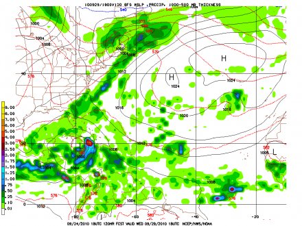 |
| gfs Wed
29th 1pm |
 |
| Euro
Thursday 30th 1pm |
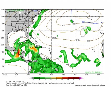 |
| No Gaps
Wed 29th
1pm |
|
|
|
- Flash Flood Watch Discontinued, T.D 13 not threat to Jamaica.
|
- By "Blayz" <blayzbrooks at hotmail.com>
- Date: Thu, 23 Sep 2010 14:02:40 -0500
|
|
Updated 2:04pm CDT
There were some light morning showers in Montego
Bay .This bring the 24hr total to 30mm/1.18inches. The sun has returned and it
has been partly cloudy weather.
It is a bit breezy with winds from the east at
21mph/18kts. The pressure steady between 1013-1011mb throughout today. The
metrological Service has discontinued
the Flash Flood Watch for Jamaica. Tropical
Depression fifteen formed in the South Central Caribbean about 290
miles South of Kingston . The system is not a threat
to Jamaica.
In fact already at its closest point
of approach for Eastern Jamaica. Our neighbors to the
West and South should monitor T.D 15 , especially with the models hinting
It may be meandering in the
Belize-Yucatan-Western Cuba -Cayman area for some days as the steering
currents will become weak until a trough lifts It out to the Gulf and
ConUs.
Persons in should follow the watches and
warnings.
For the latest
news release from the meteorological service of Jamaica
|
|
|
- Afternoon showers, flash flood watch
|
- By "Blayz" <blayzbrooks at hotmail.com>
- Date: Wed, 22 Sep 2010 17:22:52 -0500
|
|
Updated 5:18pm cdt September 22,2010
The skies across Montego Bay are mostly cloudy after
some light afternoon showers at 3pm. The skies are still very cloudy, but the
rain has ceased.
Rainfall for the past 24hrs is
8mm/0.32in . A Flash Flood Watch is in effect for
Jamaica the news release from the Met Service is below.
***
FLASH FLOOD WATCH IN EFFECT FOR ALL
PARISHES ***
The Meteorological Service has issued a Flash
Flood Watch for all parishes effective until
5:00 a.m. tomorrow.
A FLASH FLOOD WATCH
means flooding is possible and citizens are advised to take
precautionary measures, keep informed by listening to further News
Releases from the Meteorological Service and be
ready for quick action if flooding is observed or if a warning is issued.
An Area of Low Pressure is
currently generating unstable weather over most of the Central Caribbean. The disturbance is expected to
continue moving westward
and should continue to
affect the weather over Jamaica.
Currently, Satellite Imagery indicates a large area of showers with
embedded thunderstorm across the central Caribbean. RADAR imagery shows some
outbreaks of showers
and vigorous thunderstorms along
and off the south east coasts of Jamaica.
The forecast is for increasingly
cloudy conditions with continued outbreaks of showers and thunderstorms
particularly over eastern parishes this morning. Shower and thunderstorm
activity should spread to
the west later today. This is expected to persist over the island into Thursday morning as the system moves
south of the island, then into the western Caribbean.
As a result, a Flash Flood
Watch is now in effect for all parishes.
Fishers and other marine
interests are being advised to exercise caution as strong, gusty winds are
likely in the vicinity of showers and thunderstorms.
The Meteorological Service will continue to monitor the progress of
this system.
|
|
|
- Article from Bermuda Newspaper The Royal Gazette
|
- By "Blayz" <blayzbrooks at hotmail.com>
- Date: Tue, 21 Sep 2010 07:16:52 -0500
|
|
www.theroyalgazette.com
Article from the Royal Gazette
from Bermuda published September 21. 2010
Island dodges hurricane bullet::100mph winds lash
Bermuda, but no major injuries are reported and damage is less than feared
By Sam Strangeways and Tim Smith
A "thankful, grateful" Bermuda will be back in business
today ? with flights and public transport running and most homes with power ?
after Hurricane Igor proved far less devastating than predicted.
The 100 mph winds and torrential rain that lashed the Island
on Sunday evening caused only minor injuries to a few, according to the
authorities, and did not wreak disastrous damage, as feared.
Public Safety Minister David Burch said yesterday that
Bermuda seemed to have "dodged a bullet in a significant way".
Premier Ewart Brown told a press conference: "I am pleased
to stand before you as the leader of a thankful, grateful, united country.
"Together the people of Bermuda faced Hurricane Igor with
hope for the best, while determined to deal with the worst. Our hopes have been
rewarded and our prayers answered. No lives have been lost and we have avoided
catastrophic damage."
The Causeway was partially damaged but reopened at 3 p.m.
yesterday for one-way traffic and the Emergency Measures Organisation reported
in a statement: "There have been no reports of any deaths or major injuries as a
result of Hurricane Igor."
But the weekend was not without drama or mishap, as boats
were torn from their moorings and sent crashing onto the rocks, homes flooded, a
utility pole crashed on a roof, trees and branches flew through the air and
Bermuda Regiment soldiers carried out at least two rescue missions.
The power went out for almost 29,000 people overnight on
Sunday; it was expected to have been restored to all but about 5,000 homes by
today.
Three baby girls were born at King Edward VII Memorial
Hospital ? two while the hospital was on hurricane lockdown, which ended at noon
yesterday.
The first came at 9.26am on Sunday, weighing 6 lb 10oz. The
second (7 lb 14oz) arrived at 11.29 a.m. yesterday, followed by a third (6 lb
11oz) at 12.47 p.m.
Igor ? which weathermen warned could batter Bermuda with
winds as fierce as Hurricane Fabian in 2003 ? ended up being much less intense
than feared.
It dropped from a possible Category 3 on Friday to Category
1 by Sunday morning and veered to the west as it approached the Island, although
its sheer size meant it lingered for longer than could usually be expected.
The strongest winds recorded were sustained winds of
92 mph and gusts of 117 miles per hour in St. David's at 12 a.m.; Commissioner's
Point recorded 116 mph at 12.40 a.m.; and L.F. Wade International Airport 93 mph
at 11.20 p.m.
The closest point of impact for the centre of the
eye was 35 nautical miles from the airport at midnight on Sunday. However, the
storm's eye was so wide ? 50 nautical miles ? that some of the outer section
passed over the west of the Island, rendering it a direct hit.
The storm left roads mostly passable but covered in trees,
branches and other debris.
Dr. Brown spent the day travelling around the country,
checking on the damage as a clean-up got under way.
"I am proud to report that, despite the fact that many
Bermudians are still without electricity, the mood is upbeat, optimistic and
positive," he said.
"From the neighbours helping to move debris from each
other's yards, to the people helping to clear the streets, it has been all hands
on deck ? one people, one country, united to get Bermuda up and running again.
"When we look at our homes, our businesses, even our flowers
and trees, we have been spared a terrible tragedy. For that we are thankful."
Senator Burch, chairman of the Emergency Measures
Organisation (EMO), said at yesterday's 5.30 p.m. press conference that the
Regiment would be stood down within the hour.
About half of the army was embodied on Sunday morning. Apart
from helping to clear the runway at L.F. Wade International Airport and other
areas of storm debris, soldiers evacuated a 26-year-old life support patient and
transported him to King Edward VII after the power went out at his Paget home.
Captain Chris Gauntlett told The Royal Gazette the
patient ? who was paralysed in a car accident several years ago ? was moved to
hospital on Sunday afternoon, before the winds got too severe.
"The ambulance from the hospital wasn't able to collect him.
He's virtually dependent on life support equipment so a power outage presented a
problem. They had a generator but it was decided to take him to hospital."
Regiment soldiers also helped three people whose car got
stuck in sand on a beach late Sunday.
Bermuda Maritime Operations Centre said the grounding of the
government-owned three-deck Bermudian ferry was the most significant
misadventure at sea.
A duty officer said the centre was informed by Police just
after 6 p.m. on Sunday that the vessel had broken from its moorings in St.
George's harbour and run aground at Wellington Slip Road.
"We have had some other vessels aground," he said. "The
other ones are smaller, private yachts that have broken their moorings."
Dr. Brown was unable to give an estimate of the cost of
clearing up after Igor. "It's too early," he said last night. "There are still
some assessments going on. I can tell you just with my own untrained eye that it
will be significantly less than with Fabian."
Catastrophe modelling firm AIR Worldwide said the damage was
expected to cost insurers less than $100 million, due to the Island's building
standards to protect structures from the wind.
The Royal Navy's destroyer HMS Manchester was still
heading to Bermuda yesterday afternoon after a rough voyage, according to Sen.
Burch. It had been on standby with a helicopter to assess the damage after the
hurricane passed.
The emergency shelter at CedarBridge Academy was used by 67
people, including a few children.
Volunteers said people ? some homeless and some who felt
unsafe at home ? were still walking into the venue at the height of the
hurricane.
The hospital's emergency room treated 22 people between 9
a.m. Sunday and 10.30 a.m. yesterday and the Lambe Foggo urgent care centre in
the east end treated eight people. None were for storm-related injuries. Doctors
treated a few people for minor injuries connected to the storm later yesterday.
Today, L.F. Wade International Airport will reopen and all
flights are expected to arrive and depart. Buses will be running from 6 a.m. and
the pink public ferry service will resume at noon.
Schools will remain closed until tomorrow, with the
exception of the Bermuda Institute, which will be open today.
Having now passed Bermuda, Igor was yesterday continuing to
weaken as it headed north east across the Atlantic, although it was still
causing rip torrents along the New Jersey shore.
? The public can call the EMO at 292-6325 or 292-6339.
|
|
|
- Early morning thunderstorm
|
- By "Blayz" <blayzbrooks at hotmail.com>
- Date: Fri, 17 Sep 2010 00:50:29 -0500
|
|
Updated 12: 48 am September r17,2010
Early morning thunderstorms have brought squally
weather and 0. 38in or 10 mm of rain within the past hour. The rain has stopped
and It will be a cool start to the morning.
|
|
|
- Sleeping Perhaps!!!
|
- By O'Neil Clarke <hurricane_spotter at hotmail.com>
- Date: Wed, 15 Sep 2010 21:09:31 -0500
|
|
Well Well Well...looking at the recent loops of Igor has shown that the eye is fully closed and to me it has literally stopped moving...Is he sleeping, is he really tired or is it that he has not decided where to go yet...he is a huge storm and it now seem sluggish but dangerous...I will be waiting for the 11pm discussion to read what is said...Goodnight folks.
|
|
|
- NAP TIME!!!
|
- By O'Neil Clarke <hurricane_spotter at hotmail.com>
- Date: Wed, 15 Sep 2010 15:39:12 -0500
|
|
Hurricane Igor after being at Cat 4 strength for so long has now become tired and is now taking a Nap as his eye is now closed....Shhhhhh, don't wake him, please...lol
|
|
|
- SPIRAL BANDS!!!
|
- By O'Neil Clarke <hurricane_spotter at hotmail.com>
- Date: Wed, 15 Sep 2010 15:33:49 -0500
|
|
Wow, look at the Spiral Bands of Karl as a Tropical Storm...imagine if it had built up earlier how large a Hurricane it might have been. Here in Kingston since yesterday we get a loud roll of thunder every now and then...kinda seems weird when no precipitation follows. All in all, the weather is lovely.
|
|
|
- Heavy Rains Affect Roadways in Some Parishes, weather returning to normal .
|
- By Blayz Brooks <blayzbrooks at yahoo.com>
- Date: Mon, 13 Sep 2010 19:47:57 -0700 (PDT)
|
| | | | |
Updated 9:37pm September 13,2010
The skies are clearing tonight in Montego Bay. The bad weather has moved away, I am able to see the star and the moon. Tomorrow will be nice and sunny. It was a very cool day,the inclement weather keeping temperature cool. In Montego Bay the high temperature was 28deg C; usually it would be 33deg Total rainfall from the tropical disturbance only 3mm/0.10in. Kingston saw more activity 25mm/1in of rain. Northeastern Parishes especially St. Mary, Portland and St. Thomas which are very mountainous saw heavy rain resulting in some roadways been affect. Below is a news release from the national works agency
For latest news release from metservice http://www.metservice.gov.jm/news.asp?id=8631
The National Works Agency (NWA) is reporting that heavy rainfall during the past twelve hours has resulted in blockage of some roadways in four parishes.
There are land slips along the Stony Hill to Toms River main road in St. Andrew reducing sections of the roadway to single lane. In St. Catherine the Bog Walk Gorge is closed. The alternative route is through Barry or Sligoville. The Zion Hill Bridge to Free Town main road is also inundated. The alternative route is through Williamsfield and Glengoffe. In the meantime the NWA has received unconfirmed reports of landslips along the Mount Airey to Coakley main road in the parish.
In St. Mary there are minor landslips along the Junction main road. Motorists are advised to proceed with caution along this roadway. Meanwhile the Prospect main road which was blocked by a fallen tree is now clear.
Over in Portland, the Spring Hill main road in the Buff Bay Valley is reduced to single in the vicinity of the Spring Hill Police Station. Personnel from the NWA are now at the location working to have the roadway fully cleared.
The main road at Cornwall Barracks in the Rio Grande Valley, eastern Portland, 500 metres from the intersection with the Moore Town main road is also reduced to single. This roadway is slippery and motorists are advised to proceed with caution
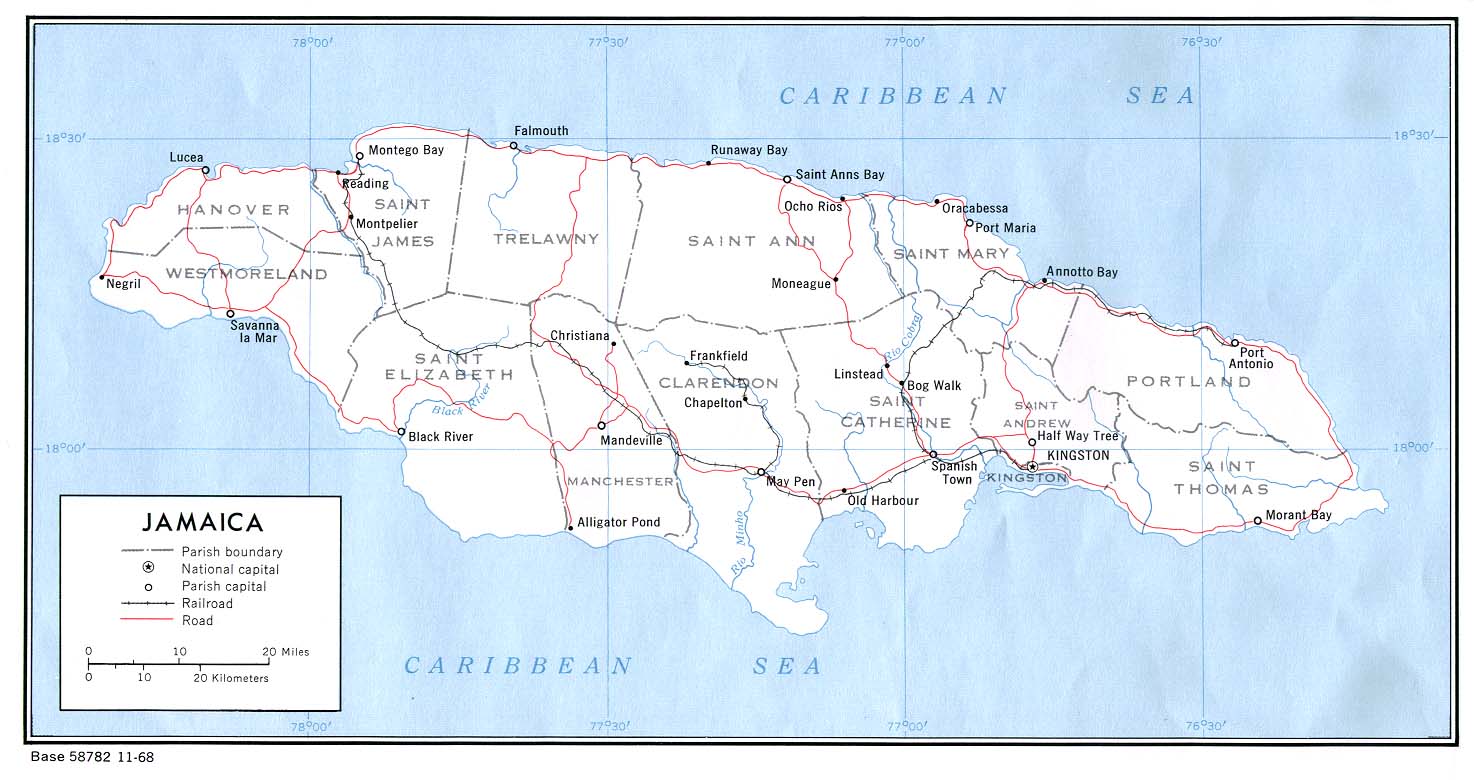
Map of Parishes of Jamaica
| | |
| |
| | |
|
Older reports from Jamaica have been moved to another page.
|