|
For the most recent reports from Jamaica see this page.
|
- Why isn't it Turning?
|
- By O'Neil Clarke <hurricane_spotter at hotmail.com>
- Date: Mon, 13 Sep 2010 20:51:05 -0500
|
|
Goodnight wonderful people of Jamrock and to the rest of the Caribbean. To borrow a line from the movie Titanic 'Why isn't it Turning?' That is what the folks to our East must be saying all day. Igor 'EEGOR' is continuing to spin below 18' North despite forecasts that it should have been way above that from yesterday and is still making a Beeline towards Antigua, St Maarten and Anguilla; hopefully 'Igor the Horrible' will see the route that has been assigned to him and follow suit pretty soon and also take a different route away from our friends to the North East in Bermuda. Early this morning in Spanish Town I woke up to see Heavy Rains from 92L pouring down accompanied with an astounding Thunder and Lightening show in which my 2 yr old daughter was fascinated while clinging tightly to me like Cheetah in Tarzan. The traffic that had built up to Kgn as early as 5:30am due to water settling on the roads was frustrating but the rain was welcome nonetheless. Tonight is rather cool and pleasant and more rain (light) is anticipated for tomorrow. Stay safe and pray for those in the Lesser Antilles.
|
|
|
- Flash Flood Watch upgraded to a Warning, moderate to heavy showers and thunderstorms across Eastern and Central Jamaica
|
- By Blayz Brooks <blayzbrooks at yahoo.com>
- Date: Mon, 13 Sep 2010 07:53:07 -0700 (PDT)
|
| | | | |
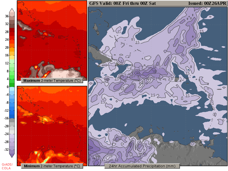
updated 9:50am September 13,2010
We are experiencing mostly cloudy skies this morning in Montego Bay. We have had some light passing showers bringing the total so far this disturbance to only 2mm/0.06in. I have been listening to local media reports and Eastern and Central Jamaica has been experiencing occasionally heavy rainfall since 2am. Some schools in region 6, Clarendon and St. Catherine are closed today due the inclement weather. There are reports of flooded roads and landslides a few being Temple Hall main road blocked due to landslides, the junction main road blocked due to flooding.The Bog Walk Gorge which links the North Coast of Jamaica to the South Coast is closed to vechicular traffic.According to ODPEM
"At report time, water levels within the Gorge were recorded at 13 feet, well in excess of the 8 feet critical level. Motorists are being urged to heed the directives from the Police on the ground. "
The meteorological service has upgraded the flash flood watch to a flash flood warning speaking on radio this morning, the duty forecaster mentioned Doppler radar indicated moderate to heavy rainfall especially across NE Parishes, Portland, St. Thomas , St. Mary, also St. Elizabeth, Clarendon and St. Catherine since last night.The forecast is for the inclement weather to persist into tomorrow returning to normal on Wednesday.
The latest news release from the meteorological service is available at http://www.metservice.gov.jm/news.asp?id=8622
Comparison between Montego Bay and Kingston at 7amCDT
At 7am CDT Norman Manley airport in Kingston reported a light rain showers, (Montego Bay was mostly cloudy) a temperature of 23 deg C , which five degrees cooler than Montego Bay at 28 deg C. The pressure was 1007mb, Montego Bay was 1009mb. In Kingston the six hour rainfall was 17 mm or 0.67in .
Radar from Cuban Met institute

| | |
| |
| | |
|
|
- Rain is here... 92L?!
|
- By Tracy Voelk <negriltracy at aol.com>
- Date: Mon, 13 Sep 2010 03:50:22 -0400
|
|
Rain started about a half hour ago in Kingston and is coming down steadily but there is not much wind which hopefully will continue!!!
|
|
- FLASH FLOOD WATCH IN EFFECT as low pressure areas approaches Jamaica.
|
- By Blayz Brooks <blayzbrooks at yahoo.com>
- Date: Sun, 12 Sep 2010 16:42:52 -0700 (PDT)
|
| | | | |
Updated September 12, 2010 7:45edt
It was a mainly fair day and we had a wonderful sunset this afternoon.There are a few high clouds and low puffy cumlus clouds. The pressure this time yesterday was 1012mb , at 7pm it is 1009mb. Last week was the start of the school year, which aside from lack of furniture, and a few other hiccups opened smoothly, although the high road traffic has returned with the school year. I spent much of Sunday evening clearing drains which have proved problematic with recent rains. The meteorological Service has issued a Flash Flood Watch for the entire Island. This watch may likely be upgraded to a flash flood warning tomorrow.
An area of disturbed weather centered some 300 miles SE of Kingston is this evening been investigated by the Hurricane Hunters to determine if a Tropical Depression or Storm is forming. Regardless of tropical development this system will produce heavy rains daily amounts of 2-4inches /50mm-101mm which could cause life threatening flash flooding and mudslides tomorrow (Monday) and Tuesday. Last night, the system was well on its way to becoming a tropical depression but lucky for us it collapsed due to some dry air. It still has a good chance of developing in the vicinity or after it passes the Island.
The release from the Met Office is below
The Meteorological Service has issued a Flash Flood Watch Low-lying and Flood prone areas of all parishes until 5:00 pm tomorrow.
FLASH FLOOD WATCH means flash flooding is possible and residents are advised to check precautionary measures, keep informed by listening to further releases from the Meteorological Service and be ready for quick action if flooding is observed or if a warning is issued.
A broad area of Low Pressure is now located south of Hispaniola and is moving toward the west.
Satellite imagery indicates that the cloudiness and thunderstorms associated with the Low Pressure system remain disorganized. Conditions are, however, favourable for gradual development and a tropical cyclone could still form during the next day or two as the system moves toward the western Caribbean Sea.
As the system progress closer to Jamaica, heavy showers and flash flooding are possible.
Due to the current potential for the system to strengthen while moving westward, marine interests are advised that weather conditions will gradually deteriorate today and tomorrow. Thundershowers and strong, gusty winds are forecast over southern waters and small craft operators, especially fishers on the cays and banks, should exercise extreme caution. Those in port are urged not to venture far from the mainland.
The Meteorological Service will continue to monitor the progress of this system and all interests should pay special attention to subsequent Releases.
| | |
| |
| | |
|
|
- STRENGTH to STRENGTH...!!!
|
- By O'Neil Clarke <hurricane_spotter at hotmail.com>
- Date: Fri, 10 Sep 2010 11:09:32 -0500
|
|
Looking to the far east at Tropical Depression Igor and all I can say is 'WHAT A ROBUST LOOKING DEPRESSION, NEVER SEEN ONE LIKE THAT BEFORE'. Now back in our neck of the woods, I am surely not seeing what NHC is (that is why I am a correspondent and they are the National Hurricane Centre)...92L to become a Storm or Hurricane and possibly pose some sort of threat to us....Gaston looked far much better, even when it had dissipated to a remnant low south of DOM REP...well, the season is at its peak today so we all better take things seriously...Walk Good...Gone to a Barbeque in lovely Kingston weather.
|
|
|
- Increased rainfall Thurday through Saturday as remnants of Gaston and trough influence Jamaica's weather
|
- By Blayz Brooks <blayzbrooks at yahoo.com>
- Date: Wed, 8 Sep 2010 21:15:53 -0700 (PDT)
|
 | | |
The Western sections of Montego Bay have seen some flash flooding in the past week and a half which have claimed one life and injured ten. It happened in the Reading/Long Hill area, which is a popular route, taken daily by hundreds of commuters linking the parishes of Hanover, Westmoreland, St. Elizabeth to St. James and the City of Montego Bay. Long hill main road goes up a hill which approximately 400ft and is very winding. According to reports all the rain which has fallen in the past month had been blocked somewhere up the hilly. The water has been building and building and Sunday 31st, the heavy rain pushed and released whatever was blocking the springs and runoff for the past month. The effect was similar to a dam being burst,
water gushed down the hill. People seeing what was happening ran from their cars only to wash down hill, along with cars and debris. There are a few pictures and a video of the area below
Pictures (overturn car was pused over long hill by the flood waters some 400ft)
http://www.pixjm.com/?a=1316
video (shows a section of the community, the water down the actually road was much more furious)
http://www.pixjm.com/default.aspx?a=1310#top
Article in the Jamaica gleaner about the lady who was swept away by the flood waters.
http://www.jamaica-gleaner.com/gleaner/20100831/lead/lead2.html
Along the Eastern section of Montego Bay, in the Rose Hall area, we have been experiencing daily light rains, nothing near the heavy rains that were experienced on the other side of town some 12 miles away. We have seen around 0.20in daily.
There is the potential for increased showers and thunderstorms and possible flash flooding beginning Thursday, September 9 through Saturday, September 11, 2010. When a trough combined with remnants of Tropical Storm Gaston, moves across the island. The Trough is currently producing showers and thunderstorms across much of Hispaniola and especially the waters south of Haiti. The forecast is for periods of showers and thunderstorms across most parishes during the afternoons of Thursday, Friday and Saturday. | | |
| |
|
|
|
- Persistent!!!
|
- By O'Neil Clarke <hurricane_spotter at hotmail.com>
- Date: Tue, 7 Sep 2010 12:16:15 -0500
|
|
Hi all...welcome back Sue...how things in Mo-Bay Blayz?...At mid-day I am taking a look at the tropics and what do I see...Ex-Gaston trying to make a triumphant return by entering a moister environment and currently firing up thunderstorms above its core (and still heading west). I am waiting to see what NHC has to say about this by later this afternoon or this evening...Currently...Kingston is hot, hot, hot.
|
|
|
- Dry for the moment in Kingston
|
- By Susan Mains <susanroaming at yahoo.com>
- Date: Mon, 30 Aug 2010 21:38:12 -0700 (PDT)
|
Good Evening Everyone, It is dry at the moment in Kingston. Had a cloudy morning then a couple of hours of rain over lunchtime. The weather gradually brightened up in the later afternoon. There have been some problems with electrics here and there due to lightning hits (e.g., traffic lights and the 119 service), but they seem to be back on track for now. It's also a good idea to be prepared for the possibility of upcoming flash floods while out on the roads. Hope everyone is keeping safe--walk good. Susan. ******************************** Dr. Susan Mains Department of Geography and Geology The University of the West Indies, Mona Kingston 7, Jamaica, West Indies.
|
|
- Thoughts and Prayers
|
- By "sue morris" <suemorris at cwjamaica.com>
- Date: Mon, 30 Aug 2010 18:15:38 -0500
|
|
To all our neighbours to the
east, our thoughts and prayers are with you during and after the havoc that
'Evil Earl' is creating in your area.
Stay safe everyone and a big
wake up call to all who are not affected. Earl is a classic example of how
quickly a weather disturbance can change from a TD to a major hurricane. Don't
get caught out, be prepared!
We started off the day in
Ochi this morning with thunder and rain, it looked like it might be around for
half a day. Lo and behold, about an hour later, bright blue sky, great breeze
and plenty of sun, so we had another glorious day. So for those of you who are
thinking of coming to JA for a short break, come on down - our door is always
open.
Have a great
one!
_____________________________________________________________________________________________________________________________________________________________
Sue
Morris
Island Hoppers Helicopter Tours Ltd.
Reynold's Pier
Ocho
Rios
Jamaica
www.jamaicahelicopterservices.com
PH:
(876) 974-1285
FAX: (876) 974-6452
CELL: (876)
361-1724
|
|
|
- Hurricane Earl to move near or over Barbuda, Anguilla and the Britsh Virgin Islands as possible Category 2 hurricane.
|
- By Blayz Brooks <blayzbrooks at yahoo.com>
- Date: Sun, 29 Aug 2010 19:14:02 -0700 (PDT)
|
I am listening to the radio stations out of Antigua, already the entire Antigua without power even places like the psychiatric hospital and the Headquarters of the Constabulary force. The maximum wind as of 9pm was a wind gust of 38mph at 4:30pm at that Antigua's airport as heard on the radio station
Antigua and Barbuda radio stations
http://radiotime.com/region/c_100293/Antigua-Barbuda.aspx
Some stations with less music and more hurricane coverage
97.1 Liberty radio ,Abs radio Antigua , Observer radio
Anguilla radio stations
http://radiotime.com/region/c_100291/Anguilla.aspx
Monseratt
radio Monserrat (down when I tryed to listen)
http://www.zjb.gov.ms/
St.Kitts and Nevis Radio stations
http://radiotime.com/region/c_100402/Saint_Kitts-Nevis.aspx
British Virgin Islands
http://radiotime.com/region/c_100441/Virgin_Islands_(British).aspx
U.S Virgin Islands
http://radiotime.com/region/c_100442/Virgin_Islands_(US).aspx
St.Maarten radio station lots of hurricane coverage
http://www.lovemycaribbean.info/radiostationstmaarten.aspx
Warning statements from Antigua and Barbuda mets service
ANTIGUA AND BARBUDA
BASED ON THE LATEST OBSERVATIONS AND ANALYSES, EARL IS EXPECTED TO PASS WITHIN 30 MILES TO THE NORTH OF BARBUDA AND WITHIN 60 MILES TO THE NORTH OF ANTIGUA AT AROUND 2 AM MONDAY MORNING.
HURRICANE FORCE WINDS OF ABOUT 85 MILES WITH HIGHER GUSTS ARE LIKELY ACROSS BARBUDA AND STORM FORCE WINDS OF ABOUT 60 MPH WITH HIGHER GUSTS ARE LIKELY ACORSS ANTIGUA. THESE STRONG WINDS ARE EXPECTED FROM THIS EVENING THROUGH MID MORNING TOMORROW MONDAY. THE STRONGEST WINDS WILL COME FROM BETWEEN THE NW AND SW.
ALREADY, SHOWERS AND THUNDERSTORMS, IN ASSOCIATION WITH OUTER RAINBANDS, ARE AFFECTING THE ISLANDS. OVER THE NEXT 24 HOURS IN EXCESS OF 5 INCHES OF RAINFALL ARE EXPECTED ACROSS THE AREA; HENCE, RESIDENTS IN LOW LYING AND FLOOD PRONE AREAS SHOULD GUARD AGAINST MAJOR FLASH FLOODING, WHICH INCLUDES MOVING TO HIGHER GROUNDS. RESIDENTS NEAR SLOPES SHOULD ALSO GUARD AGAINST MUDSLIDES.
ST. KITTS AND NEVIS
STORM FORCE WINDS OF ABOUT 60 MPH WITH HIGHER GUSTS ARE LIKELY ACORSS ST. KITTS AND NEVIS. THESE STRONG WINDS ARE EXPECTED FROM THIS EVENING THROUGH MID MORNING TOMORROW MONDAY. THE STRONGEST WINDS WILL COME FROM BETWEEN THE NW AND SW.
ALREADY, SHOWERS AND THUNDERSTORMS, IN ASSOCIATION WITH OUTER RAINBANDS, ARE AFFECTING THE ISLANDS. OVER THE NEXT 24 HOURS, IN EXCESS OF 5 INCHES OF RAINFALL ARE EXPECTED ACROSS THE AREA; HENCE, RESIDENTS IN LOW LYING AND FLOOD PRONE AREAS SHOULD GUARD AGAINST MAJOR FLASH FLOODING, WHICH INCLUDES MOVING TO HIGHER GROUNDS. RESIDENTS NEAR SLOPES SHOULD ALSO GUARD AGAINST MUDSLIDES.
Monserrat
BASED ON THE LATEST OBSERVATIONS AND ANALYSES, EARL IS EXPECTED TO PASS WITHIN 70 MILES TO THE NORTH OF MONTSERRAT AT AROUND 2 AM MONDAY MORNING.
STORM FORCE WINDS OF ABOUT 50 MPH WITH HIGHER GUSTS ARE LIKELY ACROSS MONTSERRAT. THESE STRONG WINDS ARE EXPECTED FROM THIS EVENING THROUGH MID MORNING TOMORROW MONDAY. THE STRONGEST WINDS WILL COME FROM BETWEEN THE NW AND SW.
ALREADY, SHOWERS AND THUNDERSTORMS, IN ASSOCIATION WITH OUTER RAINBANDS, ARE AFFECTING THE ISLANDS. OVER THE NEXT 24 HOURS IN EXCESS OF 5 INCHES OF RAINFALL ARE EXPECTED ACROSS THE AREA; HENCE, RESIDENTS IN LOW LYING AND FLOOD PRONE AREAS SHOULD GUARD AGAINST MAJOR FLASH FLOODING, WHICH INCLUDES MOVING TO HIGHER GROUNDS. RESIDENTS NEAR SLOPES SHOULD ALSO GUARD AGAINST MUDSLIDES.
SEA CONDITIONS ARE EXPECTED TO BE VERY ROUGH WITH LARGE AND DANGEROUS BATTERING WAVES ALONG WITH STORM SURGE. HENCE, MARINERS SHOULD STAY IN PORT AND SEEK SAFE ANCHORAGE AND RESIDENTS SHOULD STAY AWAY FROM THE COAST. SIGNIFICANT STORM SURGE FLOODING IS EXPECTED NEAR LOW LYING COASTAL AREAS. WAVES ARE EXPECTED TO EXCEED 10 FEET.
Anguilla
BASED ON THE LATEST OBSERVATIONS AND ANALYSES, EARL IS EXPECTED TO PASS WITHIN 30 MILES TO THE NORTH OF ANGUILLA AT AROUND 8 AM MONDAY MORNING.
HURRICANE WINDS OF ABOUT 75 MPH WITH HIGHER GUSTS ARE LIKELY ACROSS ANGUILLA. THESE STRONG WINDS ARE EXPECTED FROM AFTER 2 AM MONDAY THROUGH MONDAY AFTERNOON. THE STRONGEST WINDS WILL COME FROM BETWEEN THE NW AND SW.
ALREADY, SHOWERS AND THUNDERSTORMS, IN ASSOCIATION WITH OUTER RAINBANDS, ARE AFFECTING THE ISLAND. OVER THE NEXT 24 HOURS IN EXCESS OF 5 INCHES OF RAINFALL ARE EXPECTED ACROSS THE AREA; HENCE, RESIDENTS IN LOW LYING AND FLOOD PRONE AREAS SHOULD GUARD AGAINST MAJOR FLASH FLOODING, WHICH INCLUDES MOVING TO HIGHER GROUNDS. RESIDENTS NEAR SLOPES SHOULD ALSO GUARD AGAINST MUDSLIDES.
BRITISH VIRGIN ISLANDS
BASED ON THE LATEST OBSERVATIONS AND ANALYSES, EARL IS EXPECTED TO PASS WITHIN 30 MILES TO THE NORTH OF BRITISH VIRGIN ISLANDS AT AROUND 12 MID-DAY ON MONDAY.
HURRICANE WINDS OF ABOUT 85 MPH WITH HIGHER GUSTS ARE LIKELY ACROSS BRITISH VIRGIN ISLANDS. THESE STRONG WINDS ARE EXPECTED EARLY MONDAY MORNING THROUGH MONDAY EVENING. THE STRONGEST WINDS WILL COME FROM BETWEEN THE NW AND SW.
ALREADY, SHOWERS AND THUNDERSTORMS, IN ASSOCIATION WITH OUTER RAIN BANDS, ARE APPROACHING THE ISLANDS. OVER THE NEXT 36 HOURS IN EXCESS OF 5 INCHES OF RAINFALL ARE EXPECTED ACROSS THE AREA; HENCE, RESIDENTS IN LOW LYING AND FLOOD PRONE AREAS SHOULD GUARD AGAINST MAJOR FLASH FLOODING, WHICH INCLUDES MOVING TO HIGHER GROUNDS. RESIDENTS NEAR SLOPES SHOULD ALSO GUARD AGAINST MUDSLIDES.
|
|
- HURRICANE CONDITIONS ARE EXPECTED OVER THE NORTHERN LEEWARD ISLANDS BY SUNDAY NIGHT
|
- By Blayz Brooks <blayzbrooks at yahoo.com>
- Date: Sat, 28 Aug 2010 22:31:26 -0700 (PDT)
|
Tropical Storm Earl continues to organize and strengthen as it heads towards the Northern Leeward Islands. The National Hurricane Center has Hurricane Earl moving very near (within 50 miles) or over the Northern Leeward Islands Sunday night or Monday bringing Hurricane conditions to the area. Puerto Rico and the Virgin Islands may likely experience Hurricane conditions Monday and Monday night. Additionally 3-5 inches of rain expected. The intensity guidance suggests Earl will likely be between 75-90 mph when it moves near or across the Northern Leeward Islands, Puerto Rico and the Virgin Islands. Residents in these areas should rush their hurricane plans to completion. Residents in the Turks and Caicos, Eastern Bahamas should monitor the progress of Earl.
Emergency Shelters in Antigua and Barbuda visit http://www.antiguamet.com/Antigua_Met_files/Shelters.pdf
Emergency Shelters in St.Kitts and Nevis visit http://www.thestkittsnevisobserver.com/2010/08/27/emergency-shelters.html
Discussions and Analysis on Earl
Rob and Meg LightbownCrowntropical weather
http://www.crownweather.com/?page_id=325
Mark Suduth Hurricane Track
http://www.hurricanetrack.com/
Dr.Jeff MastersWunderground
http://www.wunderground.com/blog/JeffMasters/
Jason Moreland 28 storms
http://www.28storms.com/
Hurricane City videoblog
http://www.youtube.com/user/hurricanecitydotcom
Allan Huffman Tropical Discussion
http://www.examiner.com/weather-in-raleigh/allan-huffman
Enrique 6news
http://enrique6newshurricanecenter.wordpress.com/
Satellite imagery ,radio links, webcams from affected areas
http://www.crownweather.com/?page_id=2972
http://hurricanecity.com/
http://www.hurricanecity.com/live/
Radars
St.Maarten and Leeward Islands
http://weather.an/radar/cappisxm.html
Meteofrance
http://www.meteo.fr/temps/domtom/antilles/pack-public/animation/animMOSAIC2.html
Computer Model intensity

Computer Models
source :Evans, C. (2010, August 28). http://moe.met.fsu.edu/~acevans/models/al072010_inten.png. Retrieved August 28, 2010, from http://moe.met.fsu.edu/~acevans/models/.

Source
http://www.crownweather.com/al07wind.gif. (2010, August 29). Retrieved August 2010, 29, from www.extremewx.com.


|
|
- Glorious
|
- By "sue morris" <suemorris at cwjamaica.com>
- Date: Sat, 28 Aug 2010 10:04:34 -0500
|
|
What a glorious day in the
Ocho Rios area - blue skies with a few wispy clouds, wonderful breeze (so of
course you know the washing is blowing away on the line), sun is out - we
couldn't ask for anything better.
It is a great day for
swimming, wind-surfing, para-sailing - any activity on the water. School starts
back over the course of the next 2 weeks, so the kids are certainly going to
make the most of this last weekend.
The African coast and the
Atlantic are certainly getting active, so caution is the word of the next month.
Fortunately for us, the winds and high in the upper Atlantic are pulling the
storms west and north, so we are all set to enjoy the wonderful weather for as
long as possible.
Have a great day all, time
to take the dogs for a swim and see if they can catch any snorkels
!!!
Sue M
_____________________________________________________________________________________________________________________________________________________________
Sue
Morris
Island Hoppers Helicopter Tours Ltd.
Reynold's Pier
Ocho
Rios
Jamaica
www.jamaicahelicopterservices.com
PH:
(876) 974-1285
FAX: (876) 974-6452
CELL: (876)
361-1724
|
|
|
- busy times in the Atlantic
|
- By Blayz Brooks <blayzbrooks at yahoo.com>
- Date: Fri, 27 Aug 2010 23:25:43 -0700 (PDT)
|
Afternoon showers and thunderstorms
Since Tuesday, a low to mid-level trough has been producing daily light afternoon showers and thunderstorms across Jamaica. Total accumulation in Montego Bay (Rose Hall) since Tuesday is 35.6mm/1.40inches. A second trough induced by Hurricane Danielle will be in the Jamaica area on Sunday so more wet afternoons forecast. When the trough and Danielle moves out fair afternoons will return on Monday.
Major Hurricane Danielle
It is a busy time in the Tropical Atlantic with Hurricane Danielle, T.S Earl, and possibly Fiona trailing behind. Hurricane Danielle is the first major hurricane of this season and is now a powerful category four hurricane. A strong trough of low pressure off the U.S East coast will on Saturday push Danielle to the north and eventually to the north east away from Bermuda and into the open Atlantic. Danielle has reached its peak and increased shear from the trough along with cooler sea surface temperatures will weaken Danielle as it transitions into an extra tropical system
Forecast for Bermuda (Bermuda Weather Service, 2010) Saturday will have strong winds, gale force gusts, occasional showers, some heavy, and a chance of thunder as Danielle passes approximately 200nm to our east. Large swells will develop, especially along South Shore. Conditions begin to ease on Sunday. Cloudy, patchy, squally showers by afternoon, chance thunder... Winds north-northeasterly moderate to strong, soon
increasing strong with gusts gale force, especially in any heavier showers or thunderstorms... High near 29°C/85°F.
Tropical Storm Earl
For much of today, Tropical storm Earl organization has been affected by dry air intrusion. However the system is becoming better organized and banding features are becoming better defined. Wind shear and some additional dry air in the vicinity will be issues for Earl on Saturday. Thereafter the pattern becomes favorable for intensification all the computer guidance suggest Earl will become a major hurricane as early as Monday. All the computer guidance indicate the center of Earl will move north of the Leeward Islands (around 150miles north), but there is much of certainty in the track as mentioned by (Forecaster Blake Forecast Discussion #11 National Hurricane Center,
2010)
“A STRONG RIDGE BETWEEN EARL AND DANIELLE IS EXPECTED TO KEEP THE TROPICAL STORM MOVING GENERALLY WESTWARD FOR THE NEXTDAY OR SO. AFTER THAT TIME...EARL WILL REACH THE WESTERN PERIPHERYOF THE RIDGE AND IS EXPECTED TO TURN TOWARD THE WEST-NORTHWEST. ALTHOUGH ALL OF THE GUIDANCE SHOWS THE CENTER NORTHEAST OF THELEEWARD ISLANDS...THERE REMAINS SOME UNCERTAINTY ON HOW CLOSE EARL WILL COME. THE GFS HAS THE STRONGEST RIDGE IN THE GLOBAL MODELSAND MOVES THE CYCLONE CLOSER TO THE LEEWARD ISLANDS THAN MOST OFTHE OTHER GUIDANCE. AT THIS POINT...IT IS PRUDENT NOT TO MAKE ANY
CHANGES IN THE TRACK FORECAST IN THE FIRST COUPLE OF DAYS...ESPECIALLY SINCE THE CYCLONE HAS MOVED FASTER TOWARDS THE WEST THAN
PREVIOUSLY FORECAST.”
The northern Leeward Islands should prepare for the possibility of tropical storm conditions on Monday. It is likely we will see tropical storm watches be issued tomorrow. For Bermuda, Earl looks much more dismal than Danielle; the models have it as a category four passing closer to the Island than Danielle. Unlike Danielle passing to the east, Earl would pass to the west putting Bermuda in the more active portion of the Earl.
97L
A tropical disturbance near the Cape Verde Islands has been designated invest 97L by the hurricane center. The system has a good chance of becoming Fiona. The computer guidance hints this system will follow a path similar to Danielle and Earl towards to Islands and a recurve into the open Atlantic. There is much uncertainty and residents of the Leeward Islands, the Bahamas, Bermuda and U.S East Coast should monitor this system as the pattern could change against from recurving Fiona and this system may head as a hurricane towards the Bahamas and U.S East Coast.
Works Cited
Bermuda Weather Service. (2010, August 27). http://www.weather.bm/ForecastpublicExtended.asp. Retrieved August 2010, 28, from http://www.weather.bm/.
Forecaster Blake Forecast Discussion #11 National Hurricane Center. (2010, August 28). http://www.nhc.noaa.gov/. Retrieved August 28, 2010, from http://www.nhc.noaa.gov/text/refresh/MIATCDAT2+shtml/280255.shtml?
Website used
Bermuda Weather Service. (2010, August 27). http://www.weather.bm/ForecastpublicExtended.asp. Retrieved August 2010, 28, from http://www.weather.bm/.
Forecaster Blake Forecast Discussion #11 National Hurricane Center. (2010, August 28). http://www.nhc.noaa.gov/. Retrieved August 28, 2010, from http://www.nhc.noaa.gov/text/refresh/MIATCDAT2+shtml/280255.shtml?
|
|
- Uh Oh
|
- By "sue morris" <suemorris at cwjamaica.com>
- Date: Fri, 27 Aug 2010 08:44:00 -0500
|
|
Well Here I am !!!!!!
watching the weather closely
Sorry O'Neil, I have been
busy, but not too busy to keep a watch out on the weather. Max was certainly
right when he said the from mid August on is the time to keep our eyes
open.
Don't think that these 3
dance partners we have bouncing around in the Atlantic at the moment are coming
to visit, however - this is really the 'Heads Up' time and for those who aren't
prepared - HURRY UP!!!!
This is the
anniversary of Katrina, so if anyone has any doubts on the impact of a
major storm, just watch the news stations all weekend long and remember what it
was like.
Enjoy the sunshine and the
lovely breezes, Ocho Rios is just great at the moment, perfect tropical
weather.
Enjoy the
island
Sue M
_____________________________________________________________________________________________________________________________________________________________
Sue
Morris
Island Hoppers Helicopter Tours Ltd.
Reynold's Pier
Ocho
Rios
Jamaica
www.jamaicahelicopterservices.com
PH:
(876) 974-1285
FAX: (876) 974-6452
CELL: (876)
361-1724
|
|
|
- WAVES JUST KEEP ON ROLLIN!!!
|
- By O'Neil Clarke <hurricane_spotter at hotmail.com>
- Date: Thu, 26 Aug 2010 22:04:57 -0500
|
|
What a week hot!!!...Well forecasts have Earl keeping a westerly track a little bit longer than previous forecasts, so the Northern Islands better keep an 'EYE' out...Soon to be Fiona as shown by NOGAPS might threaten the Islands and the next wave immediately behind her...well, lets just watch and see what mind this one has...history has it that most storms to affect Jamaica in a tremendous way were male named storms. This may be ours to watch for...'Heads Up' as Sue Morris would say...where is she?
|
|
|
- Wobble Wobble!!!
|
- By O'Neil Clarke <hurricane_spotter at hotmail.com>
- Date: Mon, 23 Aug 2010 22:52:52 -0500
|
|
Hey fellow Hurricane Correspondents...Is it just me or am I noticing the Satellite loops that Danielle is currently making a dip to the south thus making her move a tad bit closer to the Lesser Antilles.
|
|
|
- Fair weather... Hurricane Danielle no threat to land
|
- By Blayz Brooks <blayzbrooks at yahoo.com>
- Date: Mon, 23 Aug 2010 20:32:21 -0700 (PDT)
|
| | | | |
Mainly fair weather persists across the Jamaica area amidst the stormy, controversial political scene. Mainly fair weather is forecast for the next five days.
The Second hurricanes of the season developed today, as the computer guidance have been hinting for the past two weeks. Danielle has been strengthening throughout today as the shear which prevented much intensification yesterday has relaxed. The hurricane is forecast to strengthen to major hurricane status (category 3) likely on Wednesday. The system may even dally with category 4 status before been weakened by wind shear toward the end of the week.
The computer guidance is tightly clustered through Saturday keeping the Hurricane well north of Islands and East of Bermuda (some 300miles). Thereafter the system is forecast to slow down or even become stationary for a few days, which may complicate the track after Saturday. So New England and Atlantic Canada will still have to monitor Danielle closely, even though the general model consensus is Danielle will recurve away from all lands areas and only be a shipping concern.
The tropical wave disturbance behind Hurricane Danielle is forecast to become Earl and follow a similar path as Danielle. Some models are hinting it will be ingested by Danielle. Danielle proximity will negatively impact Earl.
The impacts to the region will be some induced moisture Thursday and Friday across the Lesser Antilles combined with day time heating will produce scatter showers and thunderstorms on those days, Swells a bit higher than normal around 5-7 feet . For Bermuda, if the current official track holds keeping Danielle almost 400miles east. It will be a sunny day with higher than normal swells thanks to the relatively compact size of the hurricane. If the track shifts west, the situation will be different especially with some models stalling Danielle in the vicinity for up to a week.
| | |
| |
| | |
|
|
- previous post resized
|
- By Blayz Brooks <blayzbrooks at yahoo.com>
- Date: Thu, 19 Aug 2010 20:20:34 -0700 (PDT)
|
Still Clearing as tropical wave moves west
In Montego Bay, We had intervals of clouds and sunshine throughout Thursday. Currently (11pmedt) skies are mostly cloud as we are still being influenced by an active tropical wave which moved across the Island yesterday. Today’s Stats (Montego Bay Airport)
Max Temperature 93 deg F / 34 deg C
Min Temperature 75 deg F / 24 deg C
Max Wind Speed 20 mph / 32 km/h
Active day of Clouds
Yesterday, in the early morning hours (5-7amedt) there were some strong thunderstorms which created a light show against the dark sky. Most of the heaviest weather was offshore so for the past 24hrs we have had only 3mm of rainfall; however there was extensive cloud cover throughout the day and the day seemed more like January after a cold front.
Forecast Montego Bay area
The forecast for the next five days …. Mainly fair weather. There is a chance of scattered afternoon showers on Monday and Wednesday evenings. A High Pressure Ridge will remain across the central Caribbean, and then weaken by Saturday.
Tropics
There is still strong model support for the development of Hurricane between Monday and next Sunday between African and the Caribbean. Regarding the future track, the models (mainly the ECMWF and GFS) recurve the strong hurricane out to sea, away from the Caribbean, the U.S and East of Bermuda. The reasoning behind the model track is a trough of low pressure is forecast to develop next week off the U.S East Coast. This trough is forecast to tear a weakness in the high pressure ridge. Until this trough creates a weakness in the ridge, the ridge will steer the system west, in the general direction of the Lesser Antilles. When the weakness develops the system will feel the weakness and turn north away from land areas. There is still much uncertainty in the track forecast especially the turn to the north as (Sudduth, 2010) explains
“Will this future system make that turn? Most likely it will based solely on what I am seeing on the longer range models. But this is not set in stone. We're talking more than five days out in time and it is possible that the models do not "know" how strong the ridge actually is. One reason for this is because there are no upper air samples out over the vast reaches of the Atlantic so the models have to go on satellite derived data only. It will be interesting to see how things play out as we track what could very well be "Danielle" in the coming days.”
With this said we have all have to closely monitor the progress of the disturbance in the Atlantic. The strength of the ridge, trough, timing and speed of the system will heavily influence the future track of the system and there is much the models may not be picking up 7 days in advance. Persons in the Us East Coast will also have to monitor the potential for some home grown tropical troubles.
Gfs model
(Texas Tornado, 2010) 1pmedt run Aug 19

Thursday 26 1pm (1week from today)

Sunday 29th 1pm

More Computer models
http://tc.met.psu.edu/
http://moe.met.fsu.edu/tcgengifs/
Works Cited
Montego Bay Airport. (2010). http://www.wunderground.com/history/station/78388/2010/8/15/DailyHistory.html?req_city=NA&req_state=NA&req_statename=NA. Retrieved August 15, 2010, from www.wunderground.com.
Sudduth, M. (2010). Retrieved August 19, 2010, from http://www.hurricanetrack.com/.
Gfs model runTexas Tornado. (2010, August). http://www.txtornado.net/GFS/wna_slp_gfs_18z.htm#. Retrieved August 15, 2010, from http://www.txtornado.net/menu.htm.
|
|
- Clearing as tropical wave moves out
|
- By Blayz Brooks <blayzbrooks at yahoo.com>
- Date: Thu, 19 Aug 2010 20:09:37 -0700 (PDT)
|
| | | | |
Still Clearing as tropical wave moves west
In Montego Bay, We had intervals of clouds and sunshine throughout Thursday. Currently (11pmedt) skies are mostly cloud as we are still being influenced by an active tropical wave which moved across the Island yesterday. Today’s Stats (Montego Bay Airport)
Max Temperature 93 deg F / 34 deg C
Min Temperature 75 deg F / 24 deg C
Max Wind Speed 20 mph / 32 km/h
Active day of Clouds
Yesterday, in the early morning hours (5-7amedt) there were some strong thunderstorms which created a light show against the dark sky. Most of the heaviest weather was offshore so for the past 24hrs we have had only 3mm of rainfall; however there was extensive cloud cover throughout the day and the day seemed more like January after a cold front.
Forecast Montego Bay area
The forecast for the next five days …. Mainly fair weather. There is a chance of scattered afternoon showers on Monday and Wednesday evenings. A High Pressure Ridge will remain across the central Caribbean, and then weaken by Saturday.
Tropics
There is still strong model support for the development of Hurricane between Monday and next Sunday between African and the Caribbean. Regarding the future track, the models (mainly the ECMWF and GFS) recurve the strong hurricane out to sea, away from the Caribbean, the U.S and East of Bermuda. The reasoning behind the model track is a trough of low pressure is forecast to develop next week off the U.S East Coast. This trough is forecast to tear a weakness in the high pressure ridge. Until this trough creates a weakness in the ridge, the ridge will steer the system west, in the general direction of the Lesser Antilles. When the weakness develops the system will feel the weakness and turn north away from land areas. There is still much uncertainty in the track forecast especially the turn to the north as (Sudduth, 2010) explains
“Will this future system make that turn? Most likely it will based solely on what I am seeing on the longer range models. But this is not set in stone. We're talking more than five days out in time and it is possible that the models do not "know" how strong the ridge actually is. One reason for this is because there are no upper air samples out over the vast reaches of the Atlantic so the models have to go on satellite derived data only. It will be interesting to see how things play out as we track what could very well be "Danielle" in the coming days.”
With this said we have all have to closely monitor the progress of the disturbance in the Atlantic. The strength of the ridge, trough, timing and speed of the system will heavily influence the future track of the system and there is much the models may not be picking up 7 days in advance. Persons in the Us East Coast will also have to monitor the potential for some home grown tropical troubles.
Gfs model
(Texas Tornado, 2010) 1pmedt run Aug 19
Tuesday 24th 1pm

Thursday 26 1pm (1week from today)
Sunday 29th 1pm
Computer models
http://tc.met.psu.edu/
http://moe.met.fsu.edu/tcgengifs/
Works Cited
Montego Bay Airport. (2010). http://www.wunderground.com/history/station/78388/2010/8/15/DailyHistory.html?req_city=NA&req_state=NA&req_statename=NA. Retrieved August 15, 2010, from www.wunderground.com.
Sudduth, M. (2010). Retrieved August 19, 2010, from http://www.hurricanetrack.com/.
Gfs model runTexas Tornado. (2010, August). http://www.txtornado.net/GFS/wna_slp_gfs_18z.htm#. Retrieved August 15, 2010, from http://www.txtornado.net/menu.htm.
| | |
| |
| |
|
|
- Active tropical wave to move across Jamaica Wednesday evening.
|
- By Blayz Brooks <blayzbrooks at yahoo.com>
- Date: Tue, 17 Aug 2010 18:18:41 -0700 (PDT)
|
| | | | |
There were partly cloudy to mostly cloudy skies across Jamaica today. There were few scattered showers in the hilly interior this afternoon due to daytime heating. In Montego Bay, we had no rainfall, only dry thunderstorms around 3.pm.Today stats (Montego Bay Airport)…Hi…33.5 deg C /92.3 deg F Low…21.5 deg C/70.7 deg F. Winds were light between ene-se, peaked at 18mph.
Wednesday, will be a day of clouds and showers as an active tropical wave located over Hispaniola is forecast to move across the Jamaica area tomorrow evening. Environmental conditions are not conducive for development. However showers and thunderstorms are likely across all parishes, especially Wednesday afternoon.
The tropical wave near the Cape Verde Islands and a second wave behind continue to be the top discussion in the basin. Residents in the Lesser Antilles especially the Northern Leeward Islands, Virgin Islands, Bahamas and SE US coast should closely monitor the progress of these systems.
Website used
Montego Bay Airport. http://www.wunderground.com/history/station/78388/2010/8/15/DailyHistory.html?req_city=NA&req_state=NA&req_statename=NA. Retrieved August 15, 2010, from www.wunderground.com.
| | |
| |
| | |
|
|
- Rainy Sunday evening, Tropics to get busy soon
|
- By Blayz Brooks <blayzbrooks at yahoo.com>
- Date: Sun, 15 Aug 2010 18:43:21 -0700 (PDT)
|
| | | | |
Tropical Wave across the central Caribbean, combined with a trough has brought wet, stormy weather to Jamaica. Light to moderate rainfall started around 3pm Sunday afternoon. The rain continued throughout the evening at tapered off at 7:30pm. The total rainfall for (Montego Bay Airport) for the past 6hrs, which is also the rainfall for the past 24hrs is officially 31mm or 1.22in reported at the airport. I am reporting 45.6 mm/1.77in in Rose Hall, (Irwindale weather station) at 330 ft / 100 m , near Westgate the western side of town is reporting 55.9mm/2.20in.
Forecast
The trough in the Central Caribbean will linger through Wednesday. Expect Mainly fair weather with scattered afternoon showers mainly of hilly areas. Montego Bay forecast temperatures. Highs 34 deg C/93 deg F, Lows 25 deg C/77 deg F .
Tropics
Former T.D 5, which has made a loop and may redevelop into a tropical storm before making landfall in Sw Louisiana Late Tuesday. According to (Rob Lightbown Crownweather services, 2010) the day 10 -15 will become very busy.
“Looking at the long range prospects. If the model guidance is to be believed, we are looking at a very busy 10 to 15 days across the Atlantic Basin with up to 3 additional tropical cyclones forecast. The latest GFS model is forecasting the following: A major hurricane to track out into the open Atlantic in about 8 to 10 days. A second major hurricane to impact the northern Leeward Islands around August 27th and then impact the Bahamas and threaten Florida around August 30th. The GFS model is also forecasting a third tropical cyclone to form around August 25th and impact the Windward Islands and Barbados around August 30th.
As for the other model guidance, the latest European model is forecasting tropical cyclone formation in the eastern Atlantic around August 19th with a second tropical cyclone forming in the far eastern Atlantic around August 24th. Looking at the setup based on the European model, I would suspect that the first tropical cyclone would track out into the open Atlantic, however, the second tropical cyclone forecast would need to be really monitored closely.
So, here are my thoughts: I strongly believe that in just 7 to 10 days from now, we will be tracking and monitoring multiple tropical cyclones in the Atlantic Basin. Things are anticipated to get very busy by late this week right through at least the end of the month. Personally, I wouldn’t concentrate on exact storm forecast details, but instead look at the overall pattern forecast to setup and the idea of at least two tropical cyclones forming in the eastern Atlantic seems quite possible. I also wanted to note that the European model ensemble guidance continues to be further south and west with the first tropical cyclone and it’s 10 day forecast is showing a strong ridge of high pressure across much of the Atlantic and this could mean we could see the first system track further west than what is currently being forecast by the model guidance.”
We should all use this current lull to prepare for the season. I have been buying some items which tend to spike whenever there is a threat to the Island, items like kerosene oil, lanterns, tarpaulins, tin goods and repairs to leaks.
Works Cited
Irwindale weather station. (n.d.). http://www.wunderground.com/weatherstation/WXDailyHistory.asp?ID=ISAINTJA2. Retrieved August 15 , 2010, from http://www.wunderground.com: http://www.wunderground.com/weatherstation/WXDailyHistory.asp?ID=ISAINTJA2
Montego Bay Airport. (n.d.). http://www.wunderground.com/history/station/78388/2010/8/15/DailyHistory.html?req_city=NA&req_state=NA&req_statename=NA. Retrieved August 15, 2010, from www.wunderground.com.
Rob Lightbown Crownweather services. (2010, August 15). http://www.crownweather.com/?page_id=325. Retrieved August 15, 2010, from http://www.crownweather.com/?page_id=325
| | |
| |
| | |
|
|
- Hurricane Season to really pick up beginning late next week.
|
- By Blayz Brooks <blayzbrooks at yahoo.com>
- Date: Wed, 11 Aug 2010 21:22:09 -0700 (PDT)
|
| | | | | |
Seasonal weather persists across Jamaica. Warm, partly cloudy days with summertime afternoon showers.
Tropical Depression Five has dissipated another in a series of weak storms, but don’t be fooled, all the experts are warning, the period beginning August 20, will drastically increase. They will be days with two or three storms or hurricanes in the basin. The pattern will switch from one which turns out to sea, to longer track intense cyclones which are steered towards the Caribbean and the Americas. The active portion of the season will last longer, with more October and November storms. These are the reasons despite an average season so far, all the hurricane seasons forecast remain high.
The link below is an article from the Miami Herald forecasters will have more tools this season as they track cyclones
http://www.miamiherald.com/2010/08/11/1772209/storm-forecasters-receive-more.html#storyBody | | |
| |
| | |
|
|
- T.D colin passes Bermuda, could dissapate into trough of low pressure
|
- By Blayz Brooks <blayzbrooks at yahoo.com>
- Date: Sun, 8 Aug 2010 13:21:26 -0700 (PDT)
|
A quci Sunday update......Tropical storm Colin has been downgraded to a Tropical Depression status. The system continues to lose organization and could dissipate into a trough of low pressure later today. The depression has passed its closest point to Bermuda and is no longer a threat to that Island.
|
|
- weak t.s Colins to bring minimal effects , nearest to Bermuda 12:00am Monday
|
- By Blayz Brooks <blayzbrooks at yahoo.com>
- Date: Sat, 7 Aug 2010 22:51:38 -0700 (PDT)
|
| | | |
Despite low shear, and the center which was exposed for much of the life of Colin, becoming tucked under the main area of thunderstorms, Tropical storm Colin remains weak and struggling. The forecast now has 45mph T.S Colin moving 50mph west of Bermuda with the closet point of approach 12:00am Monday morning. Periods of heavy shows and thunderstorms with gusts up to tropical storm force is likely late Sunday evening into Monday. | | |
| |
| |
|
|
- sunny, hot weather, T.S Colin barely a tropical storm, stationary much of today
|
- By Blayz Brooks <blayzbrooks at yahoo.com>
- Date: Sat, 7 Aug 2010 12:01:24 -0700 (PDT)
|
| | | | | |
It is a hot Sunny day across Jamaica. The clouds have been building in the Montego Bay area, and light afternoon showers are possible. Tropical Storm Colin is barely a tropical storm winds only 40mph. The system has been barely moving the past twelve hours, and the effects of system are now anticipated beginning early Sunday morning. The system is forecast to be a weak 45 mph tropical storm as it passes Bermuda. Its closest point of approach based on the 11am advisory 60mph w of the
Island.
Bermuda forecast from the Bermuda weather service http://www.weather.bm/
Headline -
Conditions deteriorate today as TS Colin draws near.
Public Synopsis -
TS Colin is a threat to Bermuda. Conditions will deteriorate today with wind and shower activity increasing. Tropical storm conditions are expected to develop later this this evening, and persist through early midday Sunday as Colin passes just west of the Island. Conditions gradually improve Sunday afternoon. Please check for updates regularly.
Today -
Mostly cloudy, rain and showers developing, chance thunder... Winds south-southeasterly moderate to strong gusts to gale force, gradually increasing strong to gale force gusts to gale force, especially in squally showers... High near 29°C/85°F.
Tonight -
Overcast, periods of rain and heavier showers, risk thunder... Winds south-southeasterly strong to gale force gusts to storm force, veering southerly overnight... Low near 24°C/75°F.
Sunday -
Cloudy and wet start, risk thunder early, easing later... Winds south-southwesterly strong to gale force gusts to storm force, veering southwesterly strong gusts to gale force in the afternoon, then easing moderate to strong by evening, south-southwesterly moderate overnight... High near 29°C/84°F.
Monday -
Mix of sun and cloud, chance of 1 or 2 showers... Winds south-southwesterly moderate, easing light to moderate later... Low near 26°C/78°F, high near 30°C/86°F.
Tropical Storm Colin information page
http://www.crownweather.com/?page_id=1184
http://www.crownweather.com/?page_id=325
http://www.wunderground.com/blog/JeffMasters/article.html
http://www.youtube.com/user/hurricanecitydotcom
http://www.accuweather.com/video.asp
http://www.wunderground.com/blog/Weather456/show.html
http://www.justnews.com/mayfieldblog/index.html
http://www.hurricanecity.com/live/
| | |
| |
| | |
|
|
- Happy Independence , Tropical storm conditions are expected to begin Saturday afternoon in Bermuda
|
- By "Blayz" <blayzbrooks at hotmail.com>
- Date: Sat, 7 Aug 2010 01:19:47 -0500
|
Happy Birthday
Jamaica
Great weather prevailed across
Jamaica on her forty eight birthday. Thousands of Jamaicans participated in the
celebrations.) ?Prime Minister Bruce Golding said yesterday morning, that
Jamaica has failed to achieve the dreams of equality, economic stability and
basic community development embarked upon close to half a century ago when the
country gained independence from Britain. He said, however, that the dreams can
still be attained with hard work, and are refreshed and renewed each time a
Jamaican is born. Golding was speaking at the Independence Day ceremony at
King?s House this morning.
For his part, Governor General
Sir Patrick Allen, reflecting a glimmer of hope, said that our dreams can be
fulfilled and we can succeed if we believe in ourselves and our country. He said
the turbulent times seem to have shaken the faith of citizens, but we can take
hope in the ability of our leaders to come together. And Opposition Leader
Portia Simpson Miller, in a message read by Bobby Pickers gill, said Jamaica has
achieved much, despite the many drawbacks. ?My brothers and sisters, the
evidence [of achievement] is overwhelming despite our challenges,? Simpson
Miller said.? (from the Jamaica observer website
Tropical Storm
Colin
Tropical Storm Colin weakened throughout the day, now down to
45 mph. Yesterday, It seemed the system would try to make it to hurricane
strength near Bermuda, but with the increased shear this is unlikely. The center
of Colin will be as close as 30 miles w of Bermuda, with the worst of the system
impacting the Island in the evening. Sustained Tropical storm force winds are
likely to start at Saturday around 8pm with the system at its closest point
around 2AM AST on Sunday. Colin forecast to be a 60mph tropical storm at that
time. Colin?s track now takes it South of Newfoundland, so the only area of
concern is Bermuda.
Forecast
for Bermuda
Tropical storm conditions are
expected to begin Saturday afternoon and persist through early Sunday morning as
Colin passes just west of the Island. Weather conditions gradually improve
Sunday night.
Detailed
Saturday
-
Overcast, rain and showers developing, risk thunder... Winds
south-southeasterly strong gusts to gale force, increasing strong to gale force
gusts to storm force into afternoon, then gale force to storm force gusts to
storm force in the evening, variable at times overnight, veering southerly late
night... High near 29°C/84°F.
Sunday
-
Overcast, rain and showers, heavy at times, risk thunder... Winds
south-southwesterly strong to gale force gusts to storm force, easing strong
during the morning, then veering southwesterly moderate to strong in the
evening... Low near 23°C/74°F, high near 29°C/84°F.
Source
Bermuda weather service http://www.weather.bm/index.asp
|
|
|
- Happy Birtday Jamaica, Colin roars alive , threatens Bermuda
|
- By Blayz Brooks <blayzbrooks at yahoo.com>
- Date: Thu, 5 Aug 2010 21:35:54 -0700 (PDT)
|
| | | | | |
Today’s weather
A tropical wave moved across Jamaica today, bringing periods of sun and clouds across Jamaica. In Montego Bay, there were light showers and rumbles of thunder this evening, nothing accumulating. Today’s high 32 deg C, low 25 deg C, rainfall …trace.
Independence Day forecast
There will be great weather for Jamaica’s birthday. The forecast is for mostly fair conditions. There is a chance of light afternoon showers over Central and Western Parishes with yesterday’ tropical wave still in our areas. Forecast High 33 deg C, Low 26 deg C.
Happy Birthday Jamaica
On August 6, 1962 Jamaica became a nation after years of British Colonialism. Jamaicans across the world will celebrate Independence Day on Friday, Aug 6. More on this year’s celebrations from the Jamaica observer
"THE thousands expected to flock the National Stadium for the Jamaica Independence Festival Grand Gala tomorrow, are asked to wear the Jamaican colours, take a flag and transform the National Stadium into a sea of bright, bold, tropical colours in celebration of Jamaica's 48th anniversary of Independence.
Culture minister, Olivia 'Babsy' Grange, last week appealed to business enterprises and Government offices nationwide to fly the National Flag and include the national colours in their decorations and displays. According to Minister Grange the colours, the flag, and other national symbols will heighten visual impact and strengthen the national spirit.
Miss Grange is also encouraging everyone to make creative use of the national colours -- black, gold and green -- in dress and fashion accessories over the seven-days of celebrations known as Jamaica Festival.
On Independence Day there will be islandwide celebrations for the entire day including street dances, the western gala in Montego Bay, the festival street parade leaving from the Ranny Williams Entertainment Centre and culminating with the Grand Gala at the National Stadium.
The national Independence celebrations are being staged under the theme I Believe
in Jamaica.
Another article from the Jamaica Observer US congratulates Jamaica on Independence
UNITED States Secretary of State Hillary Clinton has congratulated Jamaica on its 48th year of Independence, lauding the country for its rich history and culture and the accomplishments of the people.
“Our two nations are united by our shared history, values, and hopes for the future,” Clinton said in a news release issued through the US Embassy. “We work together through Caricom to promote regional security and stability, widen opportunity and prosperity, and strengthen democratic governance and the rule of law throughout the Caribbean and across the Americas.”
Clinton said Jamaica’s contributions to the relief and rebuilding efforts in Haiti, as well as its commitment to protecting its citizens, have distinguished the country “as a determined and engaged regional partner”.
“The United States is a stronger nation thanks to the bonds of family, commerce, and culture we share with Jamaica,” she said. “Former secretary of state Colin Powell is among the many Americans of Jamaican heritage who have shaped our country and made important contributions to the global community. Today, we honor all Jamaicans and celebrate the vibrant friendship between our countries.”
Tropical Storm Colin awakes, Eyes Bermuda
The remnants of Tropical Storm Colin have regenerated into a tropical storm. Despite challenging conditions, the lopsided system has managed to reach 60mph as of 7:30pm ast. The areas at risk are Bermuda and Newfoundland which will be affected by Colin as it becomes as powerful extra tropical storm later on. Based on the 7:30pm NHC data, the forecast closest point of approach for Bermuda would be on Saturday at 10:00pm. The storm would be approximately 90 mph to the wnw of Bermuda. (The tracking the center of Colin is not very important as the heaviest weather is well east of the center.) The system at that point is forecast to be 65mph. Bringing tropical storm force gusts to Bermuda. There are however models which bring the system as Category one Hurricane Colin nearer/ over Bermuda and gust to hurricane strength is a real possibility. There is an upper level low NE of the Bahamas which is shearing Colin from the west. The high shear has pushed the worst of the weather on the northeastern side of the system and has somewhat limited further intensification. Colin will find itself in more favorable environment as it moves near Bermuda and will has the potential to strengthen into a hurricane as it recurves NE continues into the North Atlantic.
Tropical Storm Colin information page
http://www.crownweather.com/?page_id=1184
http://www.crownweather.com/?page_id=325
http://www.wunderground.com/blog/JeffMasters/article.html
http://www.youtube.com/user/hurricanecitydotcom
http://www.accuweather.com/video.asp
http://www.wunderground.com/blog/Weather456/show.html
http://www.justnews.com/mayfieldblog/index.html
| | |
| |
| | |
|
|
- Afternoon showers; Colin Weakens to Remnant Low
|
- By Blayz Brooks <blayzbrooks at yahoo.com>
- Date: Tue, 3 Aug 2010 21:14:15 -0700 (PDT)
|
 | | |
There was a mixture of sun and clouds throughout today. There were even a few rain showers this afternoon.
The day was a bit cooler due to the increased clouds and light showers. Today’s High 31 deg C /88 deg F.
The low 28 deg C/ 88 deg F. Today’s rainfall 5mm/0.2 in.
Forecast
Wednesday Aug 4,
Nice with breaks of clouds and sunshine
Thursday Aug 5
A shower in spots in the morning followed by a little rain in the afternoon.
High 31 deg C, Low 26 deg C
Friday Aug 6
Mostly cloudy and humid with periods of showers and sun.
High 32 deg C, Low 27 deg C
Saturday Aug 7
Beautiful with sun and clouds
High 33 deg c/Low 27 deg C
Sunday ,Aug 8
Thunderstorms; humid with times of clouds and sun
High 33 deg c/Low 27 deg C
Tropical storm Colin is no more, thanks to dry air, high wind shear, and Colin’s own rapid speed.
Colin is just an area of low pressure, which is great news for the region. There is a low possibility of regeneration,
but residents in Bermuda and along the US East Coast should monitor the progress of the low as if he system regain
strength,these are may be at risk.
http://www.accuweather.com/blogs/news/story/34893/colin-weakens-to-remnant-low-s.asp
http://www.crownweather.com/?page_id=325
http://www.wunderground.com/blog/JeffMasters/article.html
http://www.youtube.com/user/hurricanecitydotcom
http://www.accuweather.com/video.asp
http://www.wunderground.com/blog/Weather456/show.html
http://www.justnews.com/mayfieldblog/index.html | | |
| |
|
|
|
- Lull in the Hurricane season ending....
|
- By Blayz Brooks <blayzbrooks at yahoo.com>
- Date: Sat, 31 Jul 2010 22:34:16 -0700 (PDT)
|
Recently, we have been having Sunny days across Jamaica with beautiful sunsets. The dry air and African dust, which has contributed
to our great weather is on the decline allowing for a wetter pattern, more unstable. This pattern allows for stronger tropical waves and long track hurricanes.
The lull in the season will end as early this week as we head into the Cape Verde type, hurricane season. There is already a tropical wave and a nearby
area of low pressure near the Cape Verde Islands. The system has moderate chance of developing in the next 48hrs .The Northern Lesser Antilles should
closely monitor the system as the preliminary model guidance is pointing in the general area, but we should all monitor this system as there is much certain
this distance of time.
There is a great discussion on the system at http://www.crownweather.com/?page_id=325
|
|
- Lull in the hurricane season coming to an end.
|
- By "Blayz" <blayzbrooks at hotmail.com>
- Date: Sun, 1 Aug 2010 00:18:59 -0500
|
|
Recently, we have been having Sunny days across Jamaica with
beautiful sunsets. The dry air and African dust which has contributed
to the great weather is on the
decline allowing for a wetter pattern, with stronger tropical waves
and long track hurricanes becoming a huge concern. The lull in the season will
end as early this week
as we head into the Cape Verde type , hurricane season. There
is already tropical wave and a
nearby area of low pressure near the Cape Verde Islands. The system has a
moderate chance of developing. The Northern Lesser Antilles
should closely monitor the system as the preliminary model guidance is pointing
in the general area, but
we should all monitor this system as nothing is certain from this
distance of time.
|
|
|
- Another Dry Evening
|
- By Mike Bryant <puntacanamike at gmail.com>
- Date: Tue, 20 Jul 2010 21:25:05 -0400
|
|
This is really starting to get to me! Such impressive cloud formations on the radar and sat photos, but next to nothing in the way of rainfall. Quite boring in fact! I guess our neighbours to the east in Puerto Rico are hoarding all the rainfall!! I spent the day doing a tour to Boca de Yuma. Aside from a 10 minute moderate rain near Higuey, nothing more than gray clouds. The river is gushing brown into the turquoise bay, thus there must be something happening iin the mountains.
I leave for Canada on Thursday afternoon and with this system moving like a smail carrying a turtle, I suspect our take off might be a bit interesting! I was hoping it would be past, but it looks to be sattionary and building.
Right now...dead calm...crickets chirping....haunting! -- Punta Cana Mikes Dominican Adventure Reality Tours for People Just Like You 829 981 7989 www.freewebs.com/puntacanamike
|
|
- Rainy Kingston
|
- By Susan Mains <susanroaming at yahoo.com>
- Date: Sat, 17 Jul 2010 07:48:16 -0700 (PDT)
|
Hello, Started out a very cloudy morning and the rains have now begun in earnest here in Kingston. Could be a good day for a wee movie (or two) and some Blue Mountain coffee. Stay dry & walk good. Susan. ******************************** Dr. Susan Mains Department of Geography and Geology The University of the West Indies, Mona Kingston 7, Jamaica, West Indies.
|
|
- Rainy and windy Kingston
|
- By Susan Mains <susanroaming at yahoo.com>
- Date: Thu, 15 Jul 2010 07:43:22 -0700 (PDT)
|
Hello Everyone, It was a cloudy, cool and calm early morning here in Kingston, but the rains have now begun and it's starting to get a wee bit more on the windy side. Looking at the satellite imagery it seems as is it could be a fairly rainy day today. Keep an eye out for some possible flash flooding if you're out travelling. Walk good, Susan. ******************************** Dr. Susan Mains Department of Geography and Geology The University of the West Indies, Mona Kingston 7, Jamaica, West Indies.
|
|
- Quiet week ahead in the Tropical Atlantic
|
- By Blayz Brooks <blayzbrooks at yahoo.com>
- Date: Fri, 9 Jul 2010 22:58:57 -0700 (PDT)
|
 | | | There was a mixture of sun and clouds in the Jamaica area today. Despite warm temperatures, light sea breeze and lower humidity made the weather more comfortable than the last few days.
Last week, the city hosted the Caricom heads of Government Conference that saw many Regional leaders, including the UN Secretary General and head of the IMF to discussing the region’s future.
We are one-week from the Greatest Reggae Show on Earth, Reggae Sumfest, which annually brings thousands of people to Montego Bay. This year’s lineup includes Chris Brown and Usher in addition to our local artists. For more information visit the link below
http://reggaesumfest.com/
Today’s Stats
Max temperature 93 deg F/34 deg C
Minimum Temperature 77deg F/25 deg C
Maximum Humidity 89 %
Minimum Humidity 57 %
Max wind speed 17mph/28km/h
Events Haze, Clouds covering more than half the sky
Clouds Multi level cumulus, dense cirrus.
Forecast similar weather conditions this week.
The tropical Atlantic is very quiet. T.D 2 made landfall at the Texas/ Mexican border, did not organize enough to become T.s Bonnie. The remnants still producing heavy rainfall over North Central Mexico. There is an upper level coast of the coast of North Carolina. Not a threat to develop a trough will lift the system out to New England bringing wet weather in that area. There are few unimpressive tropical waves moving across the basin. We can look forward to a quiet week with any tropical development. | | |
| |
|
|
|
- Mostly Cloudy to overcast skies.
|
- By Blayz Brooks <blayzbrooks at yahoo.com>
- Date: Sun, 4 Jul 2010 22:05:53 -0700 (PDT)
|
It has been cloudy with periods of rain since Saturday. It rained heavily in the Western Section of town, but in the Eastern side of town the Rosehall area are only 10mm of rain in the past 24hrs. The overcast and rain are complements of a system which seems to be the clone of Alex . It is trying to develop in the same area and forecast do affect the same areas. The system is bring cloudy to shower weather to Jamaica improvement forecast on Tuesday.
|
|
- Mostly cloudy weather, Alex headed to Mexico
|
- By Blayz Brooks <blayzbrooks at yahoo.com>
- Date: Mon, 28 Jun 2010 17:06:07 -0700 (PDT)
|
Mostly cloudy conditions persist across the Montego Bay area after light showers this afternoon. Today’s total rainfall is 5 mm/0.20in. The forecast for Jamaica for the next seven days are for partly cloudy to mostly cloudy skies with a 40% of afternoon showers. Winds from the E-SE 20mph, decreasing to 15mph in the nights. Temperatures highs daily 88 deg F/ 31deg C. Lows around 77 deg F/ 25 deg C.
Tropical storm Alex spent the last 24hrs hugging the Coast of the Yucatan Peninsula. There is wind shear of 15kts and some dry air , however the system continues to slowly intensify. The upper level trough which has been shearing the system is forecast to lift out of the Gulf of Mexico allow a more favorable environment at the same time the system will be moving over warmer, deeper waters. As the trough lifts, the ridge will build steering the system to the NW, then wnw increasing in forward speed. The models are also in good agreement of a landfall in the Lower Rio Grande Valley near the Texas Mexico border , more specifically the San Fernando-Herroica Matamoros, Mexico area as a 90mph hurricane on Thursday.
|
|
- Tropical storm Alex a northern or western track?
|
- By Blayz Brooks <blayzbrooks at yahoo.com>
- Date: Sun, 27 Jun 2010 20:32:05 -0700 (PDT)
|
It was a mostly cloudy Sunday. There were periods of light showers complement of a trough induced by T.S Alex. The day’s total rainfall in Montego Bay 8mm or ¾ of an inch. Report on Tropical Storm Alex impacts on Belize from the Ap.
In El Salvador, Civil Protection chief Jorge Melendez said two people were swept away by rivers that jumped their banks. About 500 people were evacuated from their homes.
Authorities in both Guatemala and Belize were keeping an eye on rising river levels. One bridge in western Belize was swamped entirely, cutting off a remote Mennonite community. Seven homes in the Belize River Valley, outside Belize City, had their roofs blown off, and at least one structure collapsed.
Belize officials opened storm shelters in the island tourist resort of San Pedro, as 1,400 people fled for the mainland by plane and by boat.
But the country apparently avoided major damage, and emergency coordinator Noreen Fairweather said on national radio that there were no reports of injuries. People who took refuge in storm shelters were returning home.
"The weather came, but it was just normal rain, little gusts of wind and nothing much," Belize City resident Miguel Chan told APTN. "We have had normal storms that were more heavier than this."
There were no immediate reports of damage to Mexico's resort-studded Caribbean coast, which includes popular beach destinations such as Cancun, Cozumel and Playa del Carmen.
Alex has already regained tropical storm status, with no major impediment will become a hurricane in 24 hrs, and may even become a major hurricane based on the future the storm. The models are along two camps.
The steering of the storm is controlled by a ridge of high pressure to the NE. If the ridge remains strong or strength, a more western track , which would have it less time over water would take the system as a category two hurricane between Eastern Mexico or the Texas border area.
Some models have the strong upper level trough over the Eastern Us digging a weakness in the ridge allowing the system to turn more northerly which would make anywhere the from the South Texas to Louisiana coast vulnerable to a strike from a stronger hurricane Alex as It would have more days over the warm Gulf. The Hurricane Center has been favoring a more southerly track taking a Category Two Alex in the La Pesca to Tampico Mexico area on Thursday morning. Residence along the Gulf Coast should be on the monitor the progress of the storm as the models and the National Hurricane Center track have been shifting
north with each forecast period.
more discussion on the storm
http://www.wunderground.com/blog/JeffMasters/article.html
http://www.crownweather.com/?page_id=325
http://www.wunderground.com/blog/Weather456/show.html
http://www.youtube.com/user/hurricanecitydotcom
http://www.justnews.com/mayfieldblog/index.html
http://www.accuweather.com/video.asp
|
|
- Tropical storm Alex no major damage to Belize as of Sunday 12am
|
- By Blayz Brooks <blayzbrooks at yahoo.com>
- Date: Sat, 26 Jun 2010 22:46:52 -0700 (PDT)
|
Tropical storm Alex made landfall, just about 15miles north of Belize City as a 65 miles tropical storm. I have been monitoring live coverage on Belize love fm . http://lovefm.com/listen_live.php
Most of the reports are that people have been going into shelters. There have been heavy rains, gusty winds up to 48 mph, and electricity blackouts in parts of the country and a few persons have lost zinc roofs. The rivers in the north are normal, but some rivers in the Central and South of Belize that are rising.
The greatest concern is not with the tropical storm conditions now, but after the storm.
The interior of Belize is very mountainous and when all this water is squeezed into the mountain the rivers in the densely populated area may rise and cause chaos. A public official on the station has said the country has fared well; it has highlighted the countries strengths and the areas where improvement is needed.
The forecast is wet weather through to Monday for Belize .
|
|
- Dreary
|
- By "sue morris" <suemorris at cwjamaica.com>
- Date: Sat, 26 Jun 2010 19:26:37 -0500
|
|
Dreary day in Ochi today,
cloudy, windy, wet - that describes it all. We did have some dry spells but no
sun, so it had been a good day to read.
One of our staff left
yesterday for his vacation in - Belize !!!!!! Hope they are safe and sound and
enjoying the weather!
Hopefully we will see some
sun tomorrow, if not I have another book just waiting to be read. Keep dry
and safe from the weather and stay away from flooded
areas.
Sue M
_____________________________________________________________________________________________________________________________________________________________
Sue
Morris
Island Hoppers Helicopter Tours Ltd.
Reynold's Pier
Ocho
Rios
Jamaica
www.jamaicahelicopterservices.com
PH:
(876) 974-1285
FAX: (876) 974-6452
CELL: (876)
361-1724
|
|
|
- Not much rain In Mobay, not the case in Eastern Jamaica
|
- By Blayz Brooks <blayzbrooks at yahoo.com>
- Date: Fri, 25 Jun 2010 22:07:22 -0700 (PDT)
|
There were periods of clouds and light showers throughout Friday, with clearing tconditions this evening. No heavy rain, or bad weather. Total rainfall for today only 7mm. Portions of Central and Eastern Jamaica has seen squally weather , there were periods of heavy rain and 30 mph gusts. Conditions are clearing as the first tropical depression of the season soon T.s Alex moves away from our area and heads to Belize/Yucatan Peninsula eventually the Texas/ Mexico border areas.
|
|
- Squall!!!
|
- By O'Neil Clarke <hurricane_spotter at hotmail.com>
- Date: Fri, 25 Jun 2010 11:00:35 -0500
|
As I am watching the final moments of Brazil and Portugal a squall with strong winds and moderate rain is affecting the Kingston region. It was strong enough that windows had to be closed and hope that nothing loose flies through. As I close, it is still going on but not as terrible as the beginning. 93L has been felt and the Hurricane Season 2010 will be in full effect pretty soon. Needed batteries for my anemometer. Cho
Hotmail: Trusted email with Microsoft’s powerful SPAM protection. Sign up now.
|
|
|
- More bark, than bite
|
- By Blayz Brooks <blayzbrooks at yahoo.com>
- Date: Thu, 24 Jun 2010 19:31:32 -0700 (PDT)
|
A mixture of clouds and the occasional drizzle was the main weather event in Montego Bay. Aside for falling air pressure (from 1012 -1009mb)and ominous clouds ,we would not have know a system is in the vicinity. It was very dark much of today, but barely a drizzle only a trace of rain in the past 24 hrs. In Capital city, Kingston (130 miles) south, there has been intermittent light rain for the past 24hrs , totaling 0.2 inch. Luckily, so far the heavier activity has moved to the south.
http://www.wunderground.com/history/airport/MKJP/2010/6/24/DailyHistory.html
A flash flood warning has benn issued until 5:00pm tomorrow news release below “
*** FLASH FLOOD WARNING REMAINS IN EFFECT ***
The Meteorological Service has extended the Flash Flood Warning for low-lying and flood-prone areas of all parishes until 5:00 p.m. tomorrow..
A Flash Flood Warning means that flooding has been reported or will occur shortly. Motorists and pedestrians should not attempt to cross flooded roadways or other low-lying areas as strong currents are likely. Residents in low-lying areas should be on the alert for fast rising waters and be ready to move quickly to higher ground.
The island continues to be affected by unstable weather conditions as a result of a Strong Tropical Wave, across the western Caribbean, which continues to produce widespread showers and isolated thunderstorms across Jamaica. However, another Tropical Wave across the central Caribbean is expected to move across the island tomorrow.
The forecast is for the widespread showers and thunderstorms which could be heavy at times, to continue to affect all parishes tonight and tomorrow. Therefore, flash flooding is expected. The potential for the system to develop into a tropical cyclone west of Jamaica within 48 hours remains. As such, marine interests, particularly fishers on the cays and banks south of the island should exercise caution as weather conditions are expected to deteriorate tonight and tomorrow. Strong, gusty winds are also likely in showers and thunderstorms over inshore and offshore areas of the north and south coasts.
All interests should continue to pay special attention to subsequent Releases issued by the Meteorological Service.”
As the news release stated the worst from the system will move across the Jamaica area tomorrow. Periods of heavy rainfall is likely between 1/2in- 4 inches possible. It is likely the system will be upgrade to a tropical depression or storm during the next 48hrs. Check out the sites below for commentary on the future track and intensity of the system.
http://www.wunderground.com/blog/JeffMasters/article.html
http://www.crownweather.com/?page_id=325
http://www.wunderground.com/blog/Weather456/show.html
http://www.youtube.com/user/hurricanecitydotcom
http://www.justnews.com/mayfieldblog/index.html
http://www.accuweather.com/video.asp
has several video discussion on the system
|
|
- Can't make up it's mind !
|
- By "sue morris" <suemorris at cwjamaica.com>
- Date: Thu, 24 Jun 2010 17:36:21 -0500
|
|
The morning started off with
some sun peeping through the clouds - several of us got together last night for
a glass of wine to discuss the weather !! Well, several glasses later and you
all know the rest. Just as well the sun wasn't shining too bright this
morning.
The winds kicked up about
noon and then the rain squalls started moving through - it is now dreary and
dismal with small on again off again showers. Not sure what tomorrow may bring,
but so far we have not had the rains we were expecting. Hopefully that will
continue, but if not, we are ready for it.
The oppressive heat has
taken a break for a little while and this is SO appreciated, lovely sleeping
weather and the dogs are even showing some signs of looking like they might
decide to get energetic !
Don't overdo it
boys.
Try to stay dry and safe
from the weather
Sue M
_____________________________________________________________________________________________________________________________________________________________
Sue
Morris
Island Hoppers Helicopter Tours Ltd.
Reynold's Pier
Ocho
Rios
Jamaica
www.jamaicahelicopterservices.com
PH:
(876) 974-1285
FAX: (876) 974-6452
CELL: (876)
361-1724
|
|
|
- Strong Tropical Wave could develop in the vicnity of Jamaica, Periods of heavy rain Wed-Friday
|
- By Blayz Brooks <blayzbrooks at yahoo.com>
- Date: Tue, 22 Jun 2010 23:03:25 -0700 (PDT)
|
It was a mainly fair day in Montego Bay. There were building clouds late this evening, mostly cloudy at this point, but no rain. Montego Bay seems to be in the lull, there have been reports from sections of the squalls. Norman Manley in Kingston picked up 15mm yesterday. Montego Bay officially no rain from the system as of Wednesday 1 am.
The meteorological service has issued a flash flood watch.
*** FLASH FLOOD WATCH IN EFFECT FOR ALL PARISHES* * *
The Meteorological Service has issued a Flash Flood Watch for low-lying and flood-prone areas of all parishes until 5:00 a.m. tomorrow.
A FLASH FLOOD WATCH means that flash flooding is possible and residents are advised to take precautionary measures, keep informed by listening to further releases from the Meteorological Service and be ready for quick action if flooding is observed or if a Warning is issued.
A strong Tropical Wave, currently near Hispaniola, is expected to continue westwards and be just east of Jamaica tonight and early Wednesday. Satellite imagery indicates large areas of showers and thunderstorms associated with this system with the capacity to produce flash floods.
Widespread showers and thunderstorms, which may be heavy at times, along with gusty winds, are also expected as the Tropical Wave moves across Jamaica on Wednesday.
With the Tropical wave showing potential to develop into a tropical cyclone near to Jamaica, fishers on the cays and banks, particularly south of the island, should not venture far from the mainland as weather conditions are expected to experience steady deterioration tomorrow and Thursday. Marine interests are advised to exercise caution as strong, gusty winds are likely in showers and thunderstorms over inshore and offshore areas.
All interests should also pay special attention to subsequent Releases issued by the Meteorological Service.
The news releases are updated every twelve hours. Visit
http://www.metservice.gov.jm/news.asp
The active tropical wave west of Jamaica is being closely monitored, as it will try to develop in the vicinity of Jamaica. Some of the models make the system Alex, which would move south of Jamaica Wednesday into Late Thursday. Most people have no clue has there has been lots of bigger news dominating locally. Whether or not It develops daily amounts of 1-3 inches are forecast with locally higher in the hilly interior.
"Ncep discussion on the system
THE SLOW TO MOVE PERTURBATION WILL SUSTAIN ORGANIZED CONVECTION
ACROSS HISPANIOLA-JAMAICA-EASTERN CUBA...WITH ACCUMULATION OF
15-20MM/DAY AND MAXIMA OF 35-70MM/DAY THROUGH 36 HRS. OVER
JAMAICA/EASTERN CUBA AND THE CAYMAN ISLANDS IT WILL FAVOR
ACCUMULATION OF 15-20MM/DAY AND MAXIMA OF 30-60MM/DAY AT 36-60
HRS. BY 60-84 HRS MAXIMA ACROSS JAMAICA WILL DECREASE TO
25-50MM/DAY...WHILE ACROSS THE CAYMAN ISLANDS-ISLA DE LA
JUVENTUD/EASTERN CUBA THE MAXIMA WILL INCREASE TO 35-70MM BY 60-84
HRS."
This system will likely become the first hurricane of the season. There are several media covering the system visit for more information
http://www.wunderground.com/blog/JeffMasters/article.html
http://www.crownweather.com/?page_id=325
http://www.wunderground.com/blog/Weather456/show.html
http://www.youtube.com/user/hurricanecitydotcom
http://www.justnews.com/mayfieldblog/index.html
http://www.accuweather.com/video.asp
has several video discussion on the system
24hrs forecast


|
|
- Here comes the Rain
|
- By "sue morris" <suemorris at cwjamaica.com>
- Date: Tue, 22 Jun 2010 17:56:40 -0500
|
|
The rains have begun in
earnest in Ocho Rios along with strong winds which are swinging all about the
place.
This morning was quite grey
and overcast and then the sun came out, so we had a great day until about
5:00 pm when it all started to happen.
So glad I got the washing
done this morning as that won't be happening for a few days now. The dogs are
loving it as the temps have dropped so it is more comfortable than it has been
for a while.
Let's hope this passes
through quickly, stay safe and dry everyone
Sue M
_____________________________________________________________________________________________________________________________________________________________
Sue
Morris
Island Hoppers Helicopter Tours Ltd.
Reynold's Pier
Ocho
Rios
Jamaica
www.jamaicahelicopterservices.com
PH:
(876) 974-1285
FAX: (876) 974-6452
CELL: (876)
361-1724
|
|
|
- Heads Up
|
- By "sue morris" <suemorris at cwjamaica.com>
- Date: Mon, 21 Jun 2010 19:12:55 -0500
|
Just received the Weather update below - need to keep a close eye on
this one. Beautiful day in Ocho Rios today, lots of sun and breeze and the
crickets are chirping up a storm out there.
Sue M
Atlantic Tropical Weather
Outlook
Mon, 21 Jun 2010
18:49:51 -0500
000
ABNT20 KNHC 212349
TWOAT
TROPICAL WEATHER OUTLOOK
NWS
TPC/NATIONAL HURRICANE CENTER MIAMI FL
800 PM EDT MON JUN 21 2010
FOR
THE NORTH ATLANTIC...CARIBBEAN SEA AND THE GULF OF MEXICO...
#5
A
VIGOROUS TROPICAL WAVE LOCATED FROM EASTERN HISPANIOLA SOUTHWARD
OVER THE
CENTRAL CARIBBEAN SEA IS PRODUCING WIDESPREAD CLOUDINESS
AND SHOWERS ACROSS
MUCH OF THE CENTRAL AND EASTERN CARIBBEAN SEA...
HISPANIOLA...PUERTO
RICO...AND NORTHERN VENEZUELA. THIS DISTURBANCE
CONTINUES TO SHOW SIGNS OF
INCREASED ORGANIZATION...AND UPPER-LEVEL
WINDS ARE CONDUCIVE FOR A TROPICAL
DEPRESSION TO FORM DURING THE
NEXT COUPLE OF DAYS. THIS WEATHER SYSTEM COULD
PRODUCE LOCALLY
HEAVY RAINFALL AND GUSTY WINDS OVER PORTIONS OF PUERTO
RICO...THE
DOMINICAN REPUBLIC...HAITI...AND THE NETHERLANDS ANTILLES DURING
THE
NEXT DAY OR SO AS THE SYSTEM MOVES WEST-NORTHWESTWARD AT 10 TO 15
MPH.
THERE IS A MEDIUM CHANCE...50 PERCENT...OF THIS SYSTEM
BECOMING A TROPICAL
CYCLONE DURING THE NEXT 48 HOURS.
ELSEWHERE...TROPICAL CYCLONE FORMATION
IS NOT EXPECTED DURING THE
NEXT 48 HOURS.
$$
FORECASTER
STEWART
_____________________________________________________________________________________________________________________________________________________________
Sue
Morris
Island Hoppers Helicopter Tours Ltd.
Reynold's Pier
Ocho
Rios
Jamaica
www.jamaicahelicopterservices.com
PH:
(876) 974-1285
FAX: (876) 974-6452
CELL: (876)
361-1724
|
|
|
- I93 is dumping on us!
|
- By "Mike Bryant" <puntacanamike at gmail.com>
- Date: Mon, 21 Jun 2010 16:04:42 -0400
|
Well, after a whole lot of watching and waiting I92 was a no
show for the east coast area. Seems the big storm bubbles over Western Puerto
Rico, fizzled on the 90 mile passage of the Mona!
Sitting here at the Corner bar enjoying football while the
same problem with my CRV gets fixed for the 3rd time…gotta
love island mechanics! I thought I would jump on and check things out and low
and behold…I93!
Although located well south, in the past hour we have received
more rain than all of I92!!! A sorry site for the vacationers, but welcome for
many of us who live here. Skies are dark….lights in the bar just went on….rain
is moderate and I think we can expect a good drenching tonight!
Cheers
PuntaCana Mike
__________ Information from ESET NOD32 Antivirus, version of virus signature database 5164 (20100601) __________
The message was checked by ESET NOD32 Antivirus.
http://www.eset.com
|
|
|
- Rain alert Late Monday - Wednesday 1/2- 2 inches daily
|
- By Blayz Brooks <blayzbrooks at yahoo.com>
- Date: Sun, 20 Jun 2010 20:50:37 -0700 (PDT)
|
Wet weather is likely starting Monday evening as a strong tropical wave moves across the Central Caribbean into the Jamaica area. The system has already brought 2-5 inches across the Leeward Islands, and Puerto Rico similar amounts are likely in Hispaniola, which is not good news for the earthquake ravaged area. Jamaica will experience less intense rainfall the bulk of which will occur on Tuesday. Rainfall of 1/2- 2 inches likely with locally higher amounts daily through Wednesday.
The energy from this system still has a potential to develop this later this week.
|
|
- strange day
|
- By "sue morris" <suemorris at cwjamaica.com>
- Date: Sat, 19 Jun 2010 20:17:42 -0500
|
|
Started off as a beautiful
morning in Ochi, sunny and a great breeze for the washing.
The dark clouds rolled in
about 10 AM and down came the rains for a couple of hours.
Sun came back out again and
the sea kicked up, if you had a surf board it would have been great - just
have to watch out for the likkle bits of reef hiding under the
waves.
After the rain stopped, the
heat started up like a sauna, so the poor dogs were comatose on the tile floors
most of the day - woke up to eat and then back to hugging the tiles - what a
life.
Stay safe all those to our
East and we really wouldn't mind if you keep Invest 92 over that way and don't
send it over to us :)
Sue M
_____________________________________________________________________________________________________________________________________________________________
Sue
Morris
Island Hoppers Helicopter Tours Ltd.
Reynold's Pier
Ocho
Rios
Jamaica
www.jamaicahelicopterservices.com
PH:
(876) 974-1285
FAX: (876) 974-6452
CELL: (876)
361-1724
|
|
|
- PHEW
|
- By "sue morris" <suemorris at cwjamaica.com>
- Date: Fri, 18 Jun 2010 19:36:55 -0500
|
|
There is only one word for
the Ocho Rios area of Jamaica at the moment - HOT !!!!
It is sweltering and the
little rains we get just turn everything in to a sauna.
Well, my time for slacking
off has ended - there just simply hasn't been enough hours in each day over the
past few months, but I am determined to do better.
We of course are watching
closely anything that remotely resembles activity in the Atlantic and then
huffing and puffing and blowing hard to keep them away from
Jamaica.
The skies are blue, the sun
is hot and the ocean is wonderful - life is good, so for all those heading this
way, bring your sunscreen and your sunglasses
Have a great
one
Sue M.
_____________________________________________________________________________________________________________________________________________________________
|
|
|
- Nice weather in Jamaica, Wet sunday
|
- By Blayz Brooks <blayzbrooks at yahoo.com>
- Date: Fri, 18 Jun 2010 08:39:33 -0700 (PDT)
|
There is a high-pressure ridge across the Central Caribbean providing a beautiful morning across Jamaica. Sunny skies, light winds with a few patches of puffy cumulus clouds. The past two weeks has seen similar weather. The forecast for the next week is for continued fair weather with the exception of late Sunday with the remnants of the tropical disturbance to our North.
The tropical disturbance (invest 92L) is currently moving through the Lesser Antilles. Periods of heavy rainfall and gusty winds are likely especially across the Leeward Islands. The squally weather shifts to Puerto Rico and the Virgin Islands Late tonight into tomorrow, thereafter Hispaniola, Eastern Cuba and Jamaica Sunday into Monday.
More from Ncep discussion
"THE EASTERLY WAVE IS TO MOVE ACROSS THE USVI BY 18-21 UTC
TODAY...ENTERING EASTERN PUERTO RICO BETWEEN 00-03 UTC THIS
EVENING...AND EJECT ACROSS THE WEST COAST OF PUERTO RICO AROUND
06-09 UTC TOMORROW MORNING. STRONG CYCLONIC ADVECTION WILL
ACCOMPANY THIS PERTURBATION AS IT MOVES ACROSS THE ISLANDS...WITH
A 20-25KT WIND SURGE TO PRECEDE WAVE PASSAGE. THE MODELS CONTINUE
TO SHOW MOST ACTIVE CONVECTION LATE TODAY INTO SATURDAY...BUT
DIVERGE ON WHERE THE ACTIVITY IS GOING TO DEVELOP. THE GFS
MAINTAINS CONTINUITY SHOWING MOST ACTIVE WEATHER DEVELOPING TO THE
NORTH OF THE VIRGIN ISLANDS...WHILE THE NAM AND ECMWF TAKE THE
CONVECTION ACROSS THE ISLAND CHAIN INTO THE VI/PUERTO RICO
FORECAST AREA.
CONSIDERING THE WIND SURGE THAT PRECEDES THE WAVE...I EXPECT
SQUALLY WEATHER DEVELOPING LATER THIS MORNING/EARLY THIS AFTERNOON
AHEAD OF THE MAIN
AXIS. BUT THIS SHOULD BE SHORT LASTING
TWO-TO-THREE HOURS OF STRONG CONVECTION...TO QUICKLY PROPAGATE
ACROSS THE VIRGIN ISLES TO EASTERN PUERTO RICO. SOME ACTIVITY WILL
THEN FOLLOW...BUT UNDER INFLUENCE OF THE TUTT TO THE NORTH...MOST
ACTIVE IN THE FORM OF AN MCS IS TO FORM JUST NORTH OF THE ISLANDS.
WE WOULD LIKELY SEE ACTIVITY ON SATURDAY-MONDAY...AS MOISTURE
POOLS ACROSS THE BASIN...BUT THE WORST SHOULD TAKE PLACE TODAY AND
EARLY AM ON SATURDAY. "
There is a possibility of development of the system during the early part of next week, when environmental conditions will become more favorable for development. For further details vist:
Caribbean weather models
24hrs gfs forecast
|
|
- BLOBBETTE AT OUR 3 O CLOCK!!!
|
- By O'Neil Clarke <hurricane_spotter at hotmail.com>
- Date: Thu, 17 Jun 2010 23:52:48 -0500
|
Wow, those thunderstorms currently being fired up by the remnants of 92L definately look impressive. I think the hurricanes for this season has sent out a scout to check on which route is safe from dust and wind shear. I think the route to the Caribbean has thus far failed in their 'EYE' sights. Wink Wink!!!
Hotmail: Trusted email with powerful SPAM protection. Sign up now.
|
|
|
- wet weather this weekend
|
- By Blayz Brooks <blayzbrooks at yahoo.com>
- Date: Mon, 14 Jun 2010 21:00:35 -0700 (PDT)
|
Great weather continues across Jamaica, This evening was a bit overcast but no rain. The tropical disturbance halfway between the Eastern Caribbean and Africa is still a tropical wave. Luckily the environment becoming less favorable, It will still bring rain to the Leewards Friday , Haiti and our area on Sunday.
Discussion on 92L to follow
great tools for tropical anaylsis
|
|
- Possible development in the Atlantic
|
- By Blayz Brooks <blayzbrooks at yahoo.com>
- Date: Sun, 13 Jun 2010 04:23:34 -0700 (PDT)
|
|
|
- It has been Rain, Rain an inch everyday
|
- By Blayz Brooks <blayzbrooks at yahoo.com>
- Date: Fri, 4 Jun 2010 00:26:42 -0700 (PDT)
|
The daily afternoon shower started earlier today.Around 1pm, which was great the sun was out before 4p.m. The rest of the day was sunny and humid. Today's High 92 deg F/33 deg C. Today's low 77 deg F/ 25 deg C. Today's Rainfall 25.1mm/1in.
Has good information on this hurricane season and area to monitor.
|
|
- First Day of Hurricane Season
|
- By Blayz Brooks <blayzbrooks at yahoo.com>
- Date: Tue, 1 Jun 2010 22:46:38 -0700 (PDT)
|
There was a heavy rain which flooded Downtown Montego Bay this afternoon , the local news reported people stranded in stores, the rain was very localized , I live 12 miles away We did not have a drop of rain, but It was very dark with thunder, the air was also cooled really quickly.
Today is the first day of the Hurricane Season. It is a day in which take time Jamaicans think about our level of preparedness, from Government, companies and individuals. We have been having hurricanes of our own as a country, but we should still try to prepare for this season clearing drains, trimming trees etc.
Dr. Jeff Masters summaries the advent of this season ,
“The hurricane season of 2010 is upon us. With unprecedented sea surface temperatures in the Atlantic, El Niño gone and possibly transitioning to La Niña, a massive oil slick in the Gulf of Mexico, a million earthquake refugees in Haiti at the mercy of a hurricane strike, and an ever-increasing number of people living on our coasts, the arrival of this year's hurricane season comes with an unusually ominous tone.”
See for full article http://www.wunderground.com/blog/JeffMasters/article.html
This will be a hurricane season similar to 2005, if the predictions of the experts pan out. Very active with increased threat to the Leeward Islands, Bahamas, Western Caribbean and South Florida.
Crown weather services has updated their hurricane outlook visit http://www.crownweather.com/?page_id=2113
In other weather news a major outbreak of severe weather is likely in the U.S Midwest and Mid Atlantic this weekend. T.S Agatha left a rain of terror in Gutamala so far 180 people , some the pictures from the AP are below.
In this photo released by Guatemala's Presidency on Monday May 31, 2010, a sinkhole covers a street intersection in downtown Guatemala City, Monday May 31, 2010. A day earlier authorities blamed the heavy rains caused by tropical storm Agatha as the cause of the crater that swallowed a a three-story building but now say they
will be conducting further studies to determine the cause.
|
|
Residents help Honduran Army soldiers clean up the damage caused by heavy rains and floods after the passing of tropical storm Agatha in Tegucigalpa, Monday May 31, 2010.(AP Photo/Fernando Antonio) |
|
|
A child reacts while villagers, unseen, recover the bodies of two people who died after a mudslide, triggered by the tropical storm Agatha, hit the village of Santa Apolonia, western Guatemala, Monday, May 31, 2010. (AP Photo/Moises Castillo) |
|
|
Women react after the bodies of relatives, killed during mudslides caused by the tropical storm Agatha, were recovered in Santa Apolonia, western Guatemala, Monday May 31, 2010. |
|
|
Residents looks for more victims after recovering some bodies of people killed during mudslides caused by the tropical storm Agatha in Santa Apolonia, western Guatemala, |
|
|
- Wet weekend, possible flash flooding, Hell of a hurricane season ahead
|
- By Blayz Brooks <blayzbrooks at yahoo.com>
- Date: Thu, 27 May 2010 22:25:22 -0700 (PDT)
|
A trough near Jamaica has brought rain every evening since this week. Today was the heaviest; there was a continuous heavy downpour with the occasional thunder. The rainfall started at 3:51pm and tapered off at 10:00pm. There was at times falling at a rate of 20mm per hour (total for today 108mm/4.25in) based on this personal weather station in the Western section of the city. http://www.wunderground.com/weatherstation/WXDailyHistory.asp?ID=ISAINTJA2
The forecast is for an Area of Low Pressure now over Honduras to move near Jamaica this weekend. Heavy rain and flash flooding is possible. Look for improving weather on Monday. Quote from accuweather.com on this weekend
"An average of 5 to 10 inches of rain is forecast to fall on the region into the weekend. However, local amounts will be higher in the mountains, where runoff will be excessive.
Waves of low pressure traveling along a stalled front, combined with heating of the day will allow clusters of heavy showers and thunderstorms to form over Haiti and other nearby island nations in the Caribbean."
So very wet weekend ahead.
Hurricane Season
All indications are this year will be a “Hell of a Hurricane season” with the experts warning of increased risk of the Caribbean. This year could be similar to 2005. The National Oceanic and Atmospheric Administration issued their predictions today; the link to the press release is below
http://www.cpc.noaa.gov/products/outlooks/hurricane.shtml
Accuweather has similar predictions, for their news story visit http://www.accuweather.com/blogs/news/story/31409/2010-atlantic-hurricane-season.asp
Accuweather.com has two very interesting graphics, showing areas of greatest risk this season.
wunderground article
http://www.wunderground.com/blog/JeffMasters/article.html
Crown weather
http://www.crownweather.com/?page_id=2113


|
|
- lots of rain
|
- By Susan Mains <susanroaming at yahoo.com>
- Date: Sat, 22 May 2010 15:40:03 -0700 (PDT)
|
Hello Everyone,
Lots of rain today in Kingston. We've had several heavy showers throughout the day and a thunderstorm at lunchtime. It has now eased off for a bit, but still heavy cloud cover.
For those of you on the road--keep an eye out for those newly (water filled) pot holes--there's a bunch!
Walk good, Susan.
******************************** Susan Mains Department of Geography and Geology The University of the West Indies, Mona
|
|
- Rainy days ahead ,possible tropiical development.
|
- By Blayz Brooks <blayzbrooks at yahoo.com>
- Date: Thu, 20 May 2010 17:13:45 -0700 (PDT)
|
It is an overcast evening in Montego Bay, after a few showers this afternoon that were mostly light. Total rainfall for the past 24hrs 13.8mm.Which begun at midday and lasted through 5pm local. The rainy weather a combination of daytime heating (today's high 33.8 deg C) along with a trough of low pressure to the west of Jamaica that stretches from Yucatan Mexico-Central Cuba to Newfoundland. This area of showers and thunderstorms will become interesting as models forecast it to become a subtropical storm on the weekend before heading to the Georgia/South Carolina coast in the early part of next week. This will enhance our chance for afternoon showers through the weekend.
The area of concern for the Jamaica, Hispaniola area is the forecast of a tropical disturbance that will dump heavy rainfall for much next week. Heavy rain is bad news for Haiti still recovering from the earthquake. There is even the possibility this disturbance may try to organize into a tropical depression we will just have to watch it.
In summary, there are two areas to watch next week for possible tropical development. They both will bring increased chance for rain, good news for the drought situation here. Highs daily 32 deg, C Lows 25 deg C, Afternoon showers and thunderstorms each day next week with up to an 1inch of rain possible .
Two great sites to get the latest analysis on these systems are http://www.wunderground.com/blog/JeffMasters/article.html
http://www.crownweather.com/?page_id=325
|
|
- seasonal hot, sunny,humid cloudy afternoon,active season ahead
|
- By Blayz Brooks <blayzbrooks at yahoo.com>
- Date: Sun, 16 May 2010 22:25:57 -0700 (PDT)
|
Great weather across Jamaica persists It has been sunny and windy at times for the past month and the forecast is fot the trend to continue.THe first tropical i
past 24hrs MONTEGO BAY PTCLDY (F/C) 92 33 79 26 no precip
The sea surface temperatures in the Atlantic are the highest on record for April which will be very troubling for this year hurricane season.There is an increased chance of more intense hurricanes. Dr. Jeff Masters has an article on it at
|
|