|
|
- - - 2021 Hurricane Season - - -
|
- 2022 Hurricane Season Info
|
- By Harry Hallstrom <hwh888 at gmail.com>
- Date: Tue, 26 Apr 2022 09:39:59 -0400
|
Greetings Everyone,
Some information about the upcoming hurricane season.............
On April 7 Colorado State University came out with a new forecast
for the upcoming hurricane season. Researchers Klotzbach and Bell
expect an above average season with 19 named storms, 9 hurricanes of
which 4 major ones.
T he islands chart says the 2022 season for St. Kitts & Nevis gives us a 15% chance of being impacted as compared to the normal of 9%.Maybe something to think about? Storm shutters in good shape?
|
|
- Nevis Weather Station Data for March
|
- By Harry Hallstrom <hwh888 at gmail.com>
- Date: Sat, 2 Apr 2022 10:46:30 -0400
|
Greetings Everyone,
Attached weather station data for March 2022 for those interested.
Attachment:
03_Mar_2022 NOAA Weather Data.pdf
Description: Adobe PDF document
|
|
- Nevis Rainfall Data from 1977-2021
|
- By "Harry W. Hallstrom" <hwh888 at gmail.com>
- Date: Tue, 11 Jan 2022 07:27:00 -0400
|
Greetings All,
Been holding on to this data for many years in text format so decided to input it into a spreadsheet format. Here are the results for those interested. The xls file is available for anyone interested. Just email me.
Attachment:
Nevis Rainfall Data 1977-2021.pdf
Description: Adobe PDF document
|
|
- December Weather Date Report
|
- By "Harry W. Hallstrom" <hwh888 at gmail.com>
- Date: Sun, 2 Jan 2022 08:10:39 -0400
|
Greetings All,
Attached December NOAA weather data for Nevis.
Annual rain amounts are quite low as compared to other years. I will look back and post the charts.
Attachment:
12_Dec_2021 NOAA Weather Data.pdf
Description: Adobe PDF document
|
|
- November NOAA Weather Station Data
|
- By "Harry W. Hallstrom" <hwh888 at gmail.com>
- Date: Sat, 11 Dec 2021 11:56:28 -0400
|
Greetings All,
Sorry a bit late at posting this info. It's here for those interested.
Attachment:
11_Nov_2021 NOAA Weather Data.pdf
Description: Adobe PDF document
|
|
- Nevis Weather Station NOAA Data
|
- By "Harry W. Hallstrom" <hwh888 at gmail.com>
- Date: Mon, 1 Nov 2021 11:00:11 -0400
|
Greetings All,
Attached station data for those interested.
Attachment:
10_Oct_2021 NOAA Weather Data.pdf
Description: Adobe PDF document
|
|
- September Weather Station Data
|
- By "Harry W. Hallstrom" <hwh888 at gmail.com>
- Date: Sat, 2 Oct 2021 20:39:50 -0400
|
Greetings All,
Attached the weather station data for the month of September for those interested.
Attachment:
09_Sep_2021 NOAA Weather Data.pdf
Description: Adobe PDF document
|
|
- Sunday 5pm Info
|
- By "Harry W. Hallstrom" <hwh888 at gmail.com>
- Date: Sun, 26 Sep 2021 18:02:19 -0400
|
Greetings All,
After looking at projections for the path of SAM it's moved even further away from St.Kitts & Nevis. I'm not going to plot, chart & measure based on what is published.
Just like the last storm.
It appears we will not even see rain or cloudy weather from SAM.
Will continue to monitor & comment if any changes.
|
|
- Storm SAM
|
- By "Harry W. Hallstrom" <hwh888 at gmail.com>
- Date: Sat, 25 Sep 2021 16:07:10 -0400
|
Greetings All,
Just had another look at projections & data from NHC as of Saturday 2pm. SAM is projected to remain away from St. Kitts & Nevis by approximately 310 mi. We will be in the 30-35 MPH wind envelope on Wednesday at 8am time frame.
NOTE: my last post estimate of 400 mi was a guesstimate as 5 day predictions didn't go out far enough.
Will have another look tomorrow afternoon to verify projected path and winds.
|
|
- Storm SAM Data & Information
|
- By "Harry W. Hallstrom" <hwh888 at gmail.com>
- Date: Fri, 24 Sep 2021 09:47:02 -0400
|
Greetings All,
Just looking at NHC predictions, analysis & predicted tracks.
This storm has a small tightly packed wind field & will continue to increase in strength with predicted winds in the 125 - 130 MPH range. The storm will slow its forward speed, that being caused by hi & low pressure systems over the Atlantic. That will determine its path to a NW turn. Based on hurricane data at day five (Wednesday 29-Sep) it will be approximately 400 miles to the NE of St.Kitt/Nevis.
So, as of today's 5am data the Leewards should be well clear of this storm.
Will have another look on Sunday am to see if the predicted path has any significant changes.
|
|
- Saturday 11 am Update Distrubance #1
|
- By "Harry W. Hallstrom" <hwh888 at gmail.com>
- Date: Sat, 18 Sep 2021 12:21:29 -0400
|
Greetings All,
Looking at NHC data and high seas reports this disturbance is projected to pass approx. 150 miles to the north of Nev/St.Kitts between Sunday - Monday.
Well away from our area. Winds in 24 hrs are forecast in the 25 kt range. Seas around disturbance are 8 ft. - 12 ft. average wave height. That means they can be double that height at times.
I doubt any fisherman will be venturing out that far from our shores.
|
|
- Next possible storm ??
|
- By "Harry W. Hallstrom" <hwh888 at gmail.com>
- Date: Tue, 14 Sep 2021 20:01:12 -0400
|
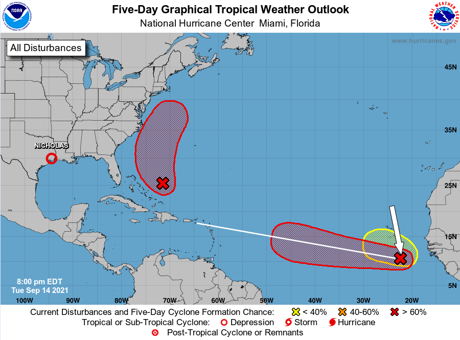
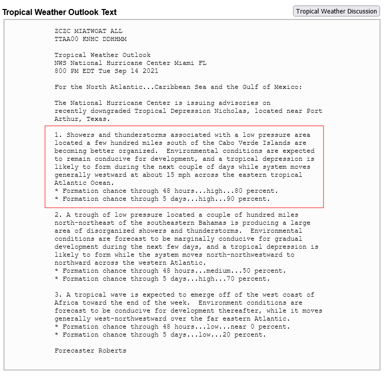
Greetings All,
Looking at NHC & satellite images this next storm could be a threat to the Leeward Islands & surrounding islands. Will have another look near end of week.
|
|
- Disturbance #2 forecast
|
- By "Harry W. Hallstrom" <hwh888 at gmail.com>
- Date: Fri, 27 Aug 2021 15:51:28 -0400
|
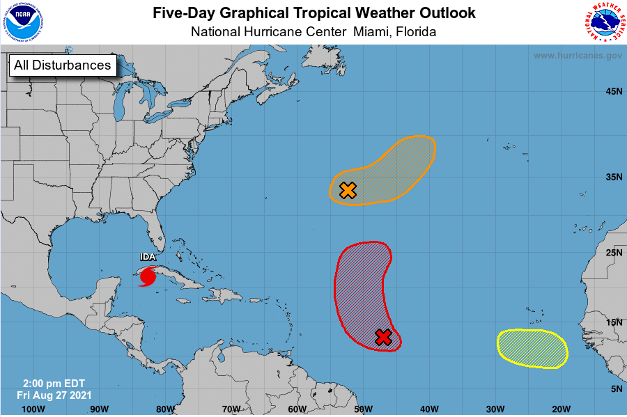
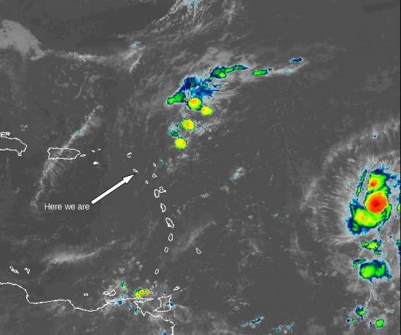
Greetings All,
The satellite image of disturbance #2 looks worse than it is.
NHC shows it turning North into the Atlantic before it gets anywhere near the Leeward Islands.
|
|
- Storm Grace Update 5am
|
- By "Harry W. Hallstrom" <hwh888 at gmail.com>
- Date: Sat, 14 Aug 2021 09:30:07 -0400
|
Greetings All.
Reading the latest 5am NHC report & plotting its path I have Grace passing directly over top of Nevis this evening/early Sunday am. Nevis/St. Kitts should expect heavy rains & squally conditions tonight. Grace is a rather fast moving storm so things should pass rather quickly.
This is the NHC report.....
For the forecast, recently upgraded Tropical Storm Grace near
15.8N 55.6W 1007 mb at 5 AM EDT is moving W at 19 kt. Maximum
sustained winds 35 kt gusts 45 kt. Grace will move to near 16.2N
58.5W this afternoon, to near 16.9N 61.8W late tonight, to near
17.7N 64.8W Sun afternoon with maximum sustained winds 45 kt gusts
55 kt, to near 18.3N 67.3W late Sun night
|
|
- Update
|
- By "Harry W. Hallstrom" <hwh888 at gmail.com>
- Date: Fri, 13 Aug 2021 11:01:13 -0300
|
Greetings all,
Another tropical depression is in store for this weekend for the Leeward Islands.
The track seems to say it will pass very close to St.Kitts & Nevis & other eastward islands.
Satellite images show a tightly packed area of storm activity so expect rain and possibly squally conditions as it passes overhead.
Keep a lookout over your shoulder.
|
|
- 11am PTC6 Nevis
|
- By Frank Goodwill <nevis.storm at hotmail.com>
- Date: Tue, 10 Aug 2021 11:26:46 -0400
|
Good morning,
11am. The rain has stopped and its brightening up. Received about 0.5 inches of rain (13mm) this morning up in the Nevis Peak foothills. From the MeteoFrance radar PTC6 has passed us by. #nevis #caribbean #notjustcovid #tropicalweather☀️☀️🌺🌺🌴🌴🌦️🌦️ #hurricane2021
https://www.instagram.com/p/CSZhNu_MAwR
Regards,
Frank Goodwill
Sent from my Huawei phone |
|
- PTC No.6
|
- By Frank Goodwill <nevis.storm at hotmail.com>
- Date: Tue, 10 Aug 2021 07:22:28 -0400
|
Good morning all,
6:50 am. PTC6 tracking to the south of us. Looks as if the rain has arrived. Rumbles of thunder and lightning, No notable high winds speeds. #Hurricane2021 #gapyearlife😎 #tropicalweather☀️☀️🌺🌺🌴🌴🌦️🌦️
https://www.instagram.com/p/CSZDNPbrXg1
Regards,
Frank Goodwill
Sent from my Huawei phone
|
|
- Storm #1 5pm
|
- By "Harry W. Hallstrom" <hwh888 at gmail.com>
- Date: Mon, 9 Aug 2021 20:38:38 -0300
|
Greetings All,
Just had another look at NHC discussion & track. The track still is posted to pass south of Nevis/ST.Kitts BUT......
When I track the actual satellite movement it appears to be tracking almost over St.Kitt & Nevis, IF IT remains on the same course. So I would be prepared for a good amount of rain and squally weather Tuesday am.
|
|
- Low Pressure System #1
|
- By "Harry W. Hallstrom" <hwh888 at gmail.com>
- Date: Mon, 9 Aug 2021 13:04:59 -0300
|
Greetings All,
The 8 am NHC report shows this system will pass to the south of the Leeward Islands tonight and move into the Caribbean Sea tomorrow (Tuesday)
NOTE the forecast is calling for the likely hood of heavy rains & flooding for the Leeward Islands.
This is the discussion from NHC.....
1. Showers and thunderstorms have become more concentrated this morning
in association with a low pressure system located about 150 miles
east of Barbados. Environmental conditions are expected to be
conducive for additional development, and a tropical depression is
likely to form later today or tonight while the low moves
west-northwestward at 10 to 15 mph.  The disturbance is forecast to
reach portions of the Lesser Antilles tonight, then move near the
Virgin Islands and Puerto Rico on Tuesday, and be near Hispaniola
around the middle of this week.  Tropical storm watches or warnings
could be required today with shorter-than-normal lead times for
portions of the Lesser Antilles, the Virgin Islands, and Puerto
Rico.  In addition, heavy rains and flooding are likely for the
Leeward Islands, Virgin Islands, and Puerto Rico.  Interests in
those areas should monitor the progress of this system.
Regards,
Harry
|
|
- Nevis Weather Station Data for July
|
- By "Harry W. Hallstrom" <hwh888 at gmail.com>
- Date: Mon, 2 Aug 2021 10:09:59 -0300
|
Greetings All,
Attached weather station data for the month of July for those interested.
From the trend I see this year=, as compared to last year, and the world wide crazy weather patterns from floods & fires. This year (summer) in the Caribbean is trending cooler than past years. Does that account for so few named storms to date?
Attachment:
07_Jul_2021 NOAA Weather Data.pdf
Description: Adobe PDF document
|
|
- Nevis Weather Station Data 2020 &2021
|
- By "Harry W. Hallstrom" <hwh888 at gmail.com>
- Date: Sat, 3 Jul 2021 13:16:32 -0300
|
Greetings All,
Attached weather data in NOAA format for June 2021 for those interested.
It seems this June was much more comfortable than last year at the same time so I looked back and sure enough. Have a look at the 90F days last year as compared to this year, just about half as many.
Does that mean anything? Who knows.
Attachment:
06_Jun_2020 NOAA Weather Data.pdf
Description: Adobe PDF document
Attachment:
06_Jun_2021 NOAA Weather Data.pdf
Description: Adobe PDF document
|
|
- Elsa and Nevis
|
- By Frank Goodwill <nevis.storm at hotmail.com>
- Date: Fri, 02 Jul 2021 21:38:47 -0400
|
Good night all,
Hurricane Elsa is fast moving and has more or less left the neighbourhood.
https://www.instagram.com/p/CQ2MOdosiUp/?utm_medium=copy_link
Regards,
Frank Goodwill
Pond Hill Weather Station, Nevis.
https://www.wunderground.com/dashboard/pws/ISAINTGE361 |
|
- Elsa and Nevis
|
- By Frank Goodwill <nevis.storm at hotmail.com>
- Date: Fri, 02 Jul 2021 17:28:51 -0400
|
Good afternoon all,
Though many miles to the south of Nevis we are feeling the effects of Hurricane Elsa. Some strong gusty winds up in the Nevis Peak foothills, but as yet no rain/showers.
https://www.instagram.com/p/CQ1r5nMMf8I/?utm_medium=copy_link Pond Hill Weather Station, Nevis.
https://www.wunderground.com/dashboard/pws/ISAINTGE361 |
|
- TS Elsa & Nevis-St.Kitts
|
- By "Harry W. Hallstrom" <hwh888 at gmail.com>
- Date: Thu, 1 Jul 2021 21:53:09 -0300
|
Greetings All,
It appears TS Else will have little or no impact on the sister islands.
1. Tropical storm conditions are expected beginning early Friday in
portions of the Windward and southern Leeward Islands, and are
possible over portions of southern Hispaniola on Saturday.

2. Heavy rainfall from Elsa will move quickly across the Windward
and southern Leeward Islands, including Barbados, on Friday. Outer
rain bands will impact Puerto Rico on Friday and southern Hispaniola
by early Saturday. Flooding and mudslides are possible.
|
|
- TD #1
|
- By "Harry W. Hallstrom" <hwh888 at gmail.com>
- Date: Wed, 30 Jun 2021 09:15:35 -0300
|
Greetings All,
There is a Tropical Depression out over the Atlantic moving westward. Read this notice from the National Hurricane Center below........
For the North Atlantic...Caribbean Sea and the Gulf of Mexico:

1. A broad area of low pressure, associated with a tropical wave, is
located about midway between the west coast of Africa and the
Windward Islands.  This system is producing a large area of showers
and thunderstorms that continues to show some signs of organization.
Environmental conditions appear generally favorable for development,
and a tropical depression is likely to form during the next few
days while the system moves west-northwestward at about 20 mph.
Interests in the Windward and Leeward Islands should closely
monitor this system as it will likely be moving through that region
on Friday.
* Formation chance through 48 hours...medium...60 percent.
* Formation chance through 5 days...high...80 percent.
|
|
- May Weather Station Data
|
- By "Harry W. Hallstrom" <hwh888 at gmail.com>
- Date: Sun, 6 Jun 2021 17:20:44 -0300
|
Greetings All,
Attached station weather data for Nevis month of May.
Attachment:
05_May_2021 NOAA Weather Data.pdf
Description: Adobe PDF document
|
|
- April NOAA Weather Sta data for Nevis
|
- By "Harry W. Hallstrom" <hwh888 at gmail.com>
- Date: Mon, 3 May 2021 11:15:36 -0300
|
Greetings All,
Attached station weather data for April 2021
Attachment:
04_Apr_2021 NOAA Weather Data.pdf
Description: Adobe PDF document
|
|
