|
|
- - - 2018 Hurricane Season - - -
|
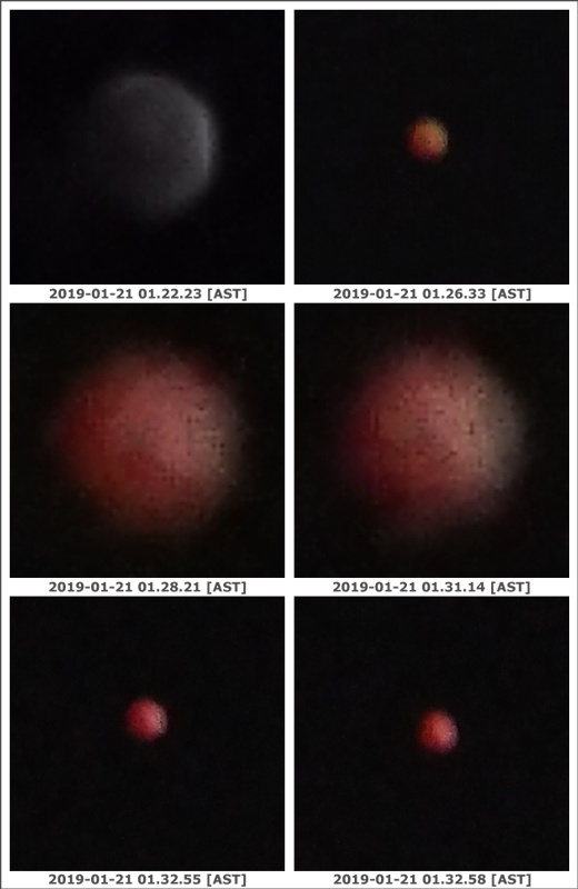
- Lunar Eclipse
|
- By Jurgen Starck <weather at turtle48.de>
- Date: Mon, 21 Jan 2019 09:38:41 -0400
|
Hi to all,
it goes without saying, that a smartphone camera is definitely NOT
the tool of choice to take decent photos of such events, but I had
no other choice. However, I like to post what I have got. The first photo shows the
total eclipse moving in. Note that the moon looks much bigger
rather than at total eclipse. The two (enlarged) photos
in the middle row have been taken with digital zoom, which makes
the moon virtually look bigger.
--
Best regards and stay safe.
Jurgen
Barbados South, near airport (BGI)
|
|
|
- The seasons are blowing us a Happy New Year, finally!
|
- By Jurgen Starck <weather at turtle48.de>
- Date: Thu, 27 Dec 2018 20:34:43 -0400
|
A Happy New Year to all in the stormcarib community and to
all the Caribbean Islanders!
I never have seen "crazy" seasons like the last two (2017, 2018)
ever before! And now, just to put the lid on the barrel this time of
year around, this comes from the Barbados Warning System Alert -
High-Wind Advisory and Small-Craft Warning" (see the CAP warning
below)! This may sound kinda dangerous but I think it may not be too
much. However, watch out everyone in BIM!
My personal hope for 2019 is, that global
warning will not bring us a more severe Hurricane Season in 2019
than the last year. However we will never know until the coming
season will be over - again. Still, let's prepare EARLY and get
ourselves protected as best as we can. Hope and prayers doesn't
help, we have seen that before. It can hit everyone of us, even
the Southern Lesser Antilles. We, down here, were just lucky in
the past years. But that may change soon! No reason to lean back,
because we got away with that in the past! We have to spruce up
our preparatory work as well! Complacency will NOT protect anyone!
2010 Hurricane Tomas hit Barbados. Just a Cat 1, but it was the
first one I have experienced in my life. We where in the eye of it
for an hour or so, don't really remember the exact duration. It
was confusing to step out for a moment and LISTEN TO ABSOLUTELY
NOTHING - NOT A SINGLE NOISE. I actually lost my balance for a
moment, due to not hearing a thing, not birds cheeping, to leaves
rattling, no car on the road, let alone planes coming in or
leaving, JUST NO NOISE AT ALL, VERY STRANGE! :-\
In the past years the hurricanes were coming more and more towards
the South of the Lesser Antilles. Look at Dominica for example! So
we down here are not out of the woods! Global warming will speed
up the Hurricanes as soon as they leave the African coast and the
more to the South they may leave the continent the more southerly
they may travel across the Atlantic. The chances to get a hit down
here is increasing, that's what I want to say. So, please don't
buy your batteries, food, fuel, generators or whatever last
minute, PLEASE plan ahead, because I have not learned to queue in
shops ahead of known things to happen, not even for things like
Christmas to come! =-O
I hope you got my message. Thanks, if you did! A bit of kidding
was included, though! ;-)
Again A Happy New Year to all of you!
Best regards and prepare early and stay safe in 2019.
Jurgen
Barbados South, near airport (BGI)
-------- Forwarded Message --------
| High-Wind
Advisory and
Small-Craft Warning
|
| Urgency
/ Severity / Certainty
|
| Expected
/ Moderate /
Observed |
|
St
Andrew
Christ
Church
St
George
St
James
St
John
St
Joseph
St
Lucy
St
Michael
St
Peter
St
Philip
St
Thomas
|
| A
strengthening
western Atlantic
high pressure system
is expected to
generate strong
surface winds and
above-normal
north-easterly to
easterly sea swells
across Barbados and
its coastal waters.
This activity will
start to affect the
area late tomorrow
(Friday) and persist
until next week
Monday. Thus, a
High-Wind Advisory
and a Small-craft
Warning will be in
effect for Barbados
and its coastal
waters from 6:00
p.m, Friday, 28th
December, 2018 until
6:00 p.m Monday 31st
December, 2018.
|
| Residents
are urged to be
vigilant and secure
all loose objects.
Small craft
operators and sea
bathers should be
prepared for large
breaking waves and
rip tides near
beaches. |
|
|
|
|
|
|
|
- A FLOOD-WATCH IS IN EFFECT FOR Barbados issued 4:00 pm
|
- By Jurgen Starck <weather at turtle48.de>
- Date: Fri, 19 Oct 2018 18:07:19 -0400
|
| A
FLOOD-WATCH IS IN
EFFECT FOR Barbados
issued 4:00 pm
|
| Urgency
/ Severity / Certainty
|
| Expected
/ Moderate /
Observed |
|
St
Andrew
Christ
Church
St
George
St
James
St
John
St
Joseph
St
Lucy
St
Michael
St
Peter
St
Philip
St
Thomas
|
| A
developing trough
system in
combination with the
I.T.C.Z which have
been affecting the
island over the past
two days, are
forecast to persist
into the weekend.
Due to the already
saturated nature of
the soils, any
additional rainfall
is likely to result
in some localized
flooding.
As a consequence, a
Flood-Watch is now
in effect for
Barbados until 12:00
noon Sunday, 21st
October, 2018.
This Watch may be
upgraded to a
Warning if
conditions warrant.
|
| Residents
in flood-prone areas
should remain on the
alert and take the
necessary
precautions.
|
|
|
|
|
|
|
|
- The most craziest storms I have ever seen...
|
- By Jurgen Starck <weather at turtle48.de>
- Date: Thu, 11 Oct 2018 23:20:31 -0400
|
Good evening to all,
this hurricane season seems to avoid any long term forecasts, that
have ever been posted! I don't know why, cuz I only see what's
really happening!
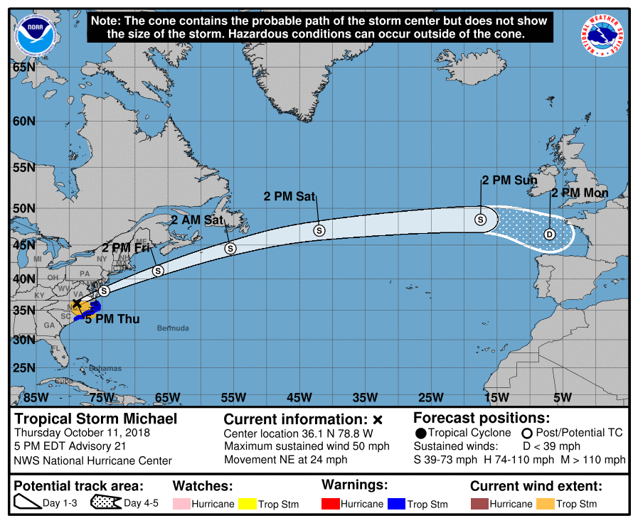
Now that Hurricane/Storm Michael having brought disaster to the
North-Eastern GOM coasts and inland is about to leave the USA and
heading for another target in Europe, I am surely amazed about the
speed that he is forecast to get there. Even though the NHC did not
mention any forward speed in it's forecast, the graphic of it's 5
day cone as of 5pm today is telling a lot! It seems that Michael is
going to push the accelerator pedal to the bottom and will be
speeding at 70 km/h through the Northern Atlantic! I am an amateur
observer of storms but nevertheless I think that forward speed might
be another record that Michael could set up, even though just being
a TS. Does anyone have an idea or records of previous forward speed
records of storms?
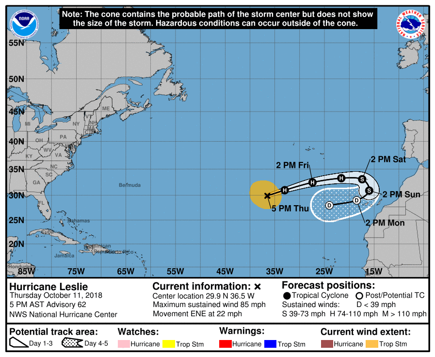
On the other hand there is still Leslie the "I don't know where to
go" H1 at this time. That is another crazy one! What is going on
with her? Not finding a date and going back home to Mama? LOL!
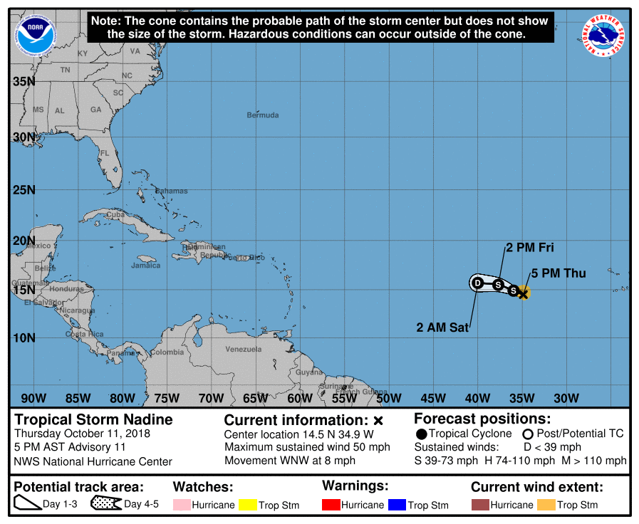
Thankfully, TS Nadine is obviously about to give up competing with
the other crazy guys around her in the Atlantic and seems to poof
away before even getting close to the Caribbean. :-)
What a crazy season!
--
Best regards and stay safe.
Jurgen
Barbados South, near airport (BGI)
|
|
|
- TS Leslie helping TS Nadine (former FIFTEEN) going North?
|
- By Jurgen Starck <weather at turtle48.de>
- Date: Tue, 9 Oct 2018 13:00:23 -0400
|
Hello everyone,
it looks like the Southern and Eastern Caribbean is getting spared from
TS Nadine. To me it looks like Nadine is getting some pull from Leslie
towards the North. However, that is only my personal impression. Let's
see how this plays out. All in all a very interesting Hurricane Season
this year.
Greetings to All.

--

Best regards and stay safe.
Jurgen

Barbados South, near airport (BGI)
|
|
- The Rain has stopped
|
- By Jurgen Starck <weather at turtle48.de>
- Date: Fri, 28 Sep 2018 10:56:11 -0400
|
|
Finally, at about 10:30 this morning the rain has stopped. It
remains to be seen, if its just a short break or the end of it.
The TS Warning for Barbados has been lifted but the Flood Warning
has been extended until 12:00 o'clock (noon). Schools are closed.
Some
houses are flooded. Power
Outages in some districts.
--

Best regards and stay safe.
Jurgen

Barbados South, near airport (BGI)
|
|
|
- Still raining...
|
- By Jurgen Starck <weather at turtle48.de>
- Date: Fri, 28 Sep 2018 09:52:32 -0400
|
Good morning to all,
it is still and
constantly raining in Barbados. Several
areas are without power.
Here
an excerpt of the latest CAP.CAP
message:
"Barbados remains under a
Tropical Storm Warning The Flood-Warning has been extended
until 8:00 a.m this morning A Flood-Warning means in this case
that flooding is already occurring. Strong winds, violent
showers, periods of rain and thunderstorms associated with the
tail-end of T.S Kirk affected Barbados overnight. Sustained
surface winds of 37 mph (60 km/h) and wind–gusts of 44 to 48
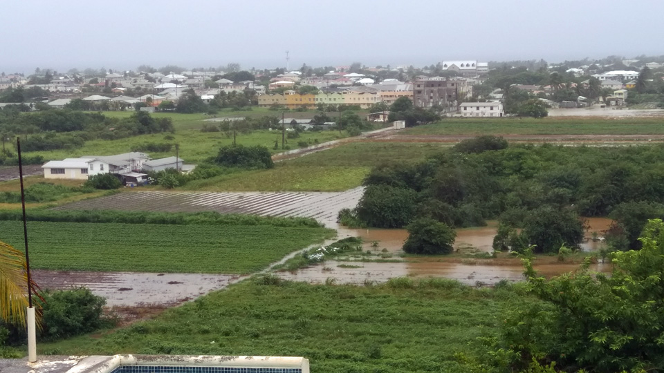
mph (71 to 77 km/h) were recorded at Charnocks while rainfall accumulations of 241.2mm
(9.5inches) were also observed."
The photo shows the flooded fields below our house, I don't
remember to have ever seen that much water down there!
Best regards and stay safe.
Jurgen

Barbados South, near airport (BGI)
|
|
|
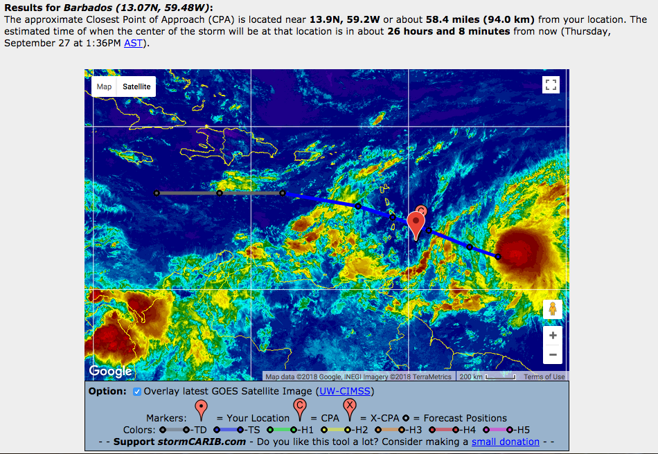
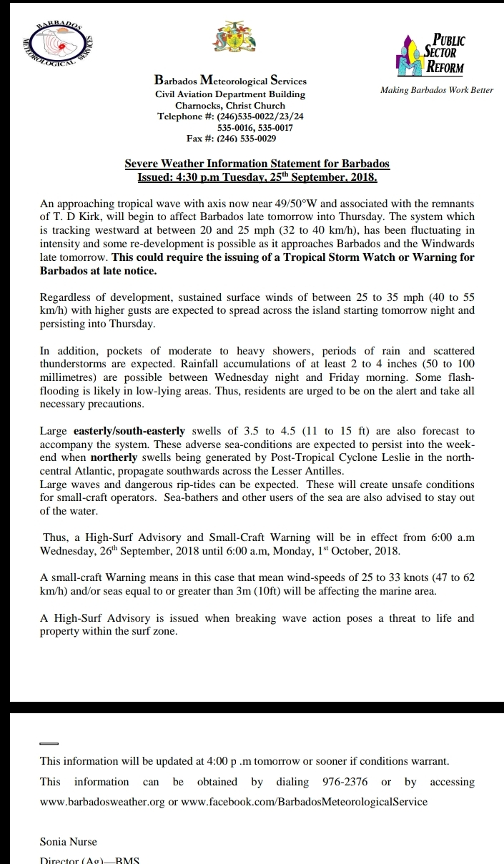
- Barbados Warning System Alert - Advisory #8 on Tropical Storm Kirk issued at 11:30 pm
|
- By Jurgen Starck <weather at turtle48.de>
- Date: Fri, 28 Sep 2018 00:55:46 -0400
|
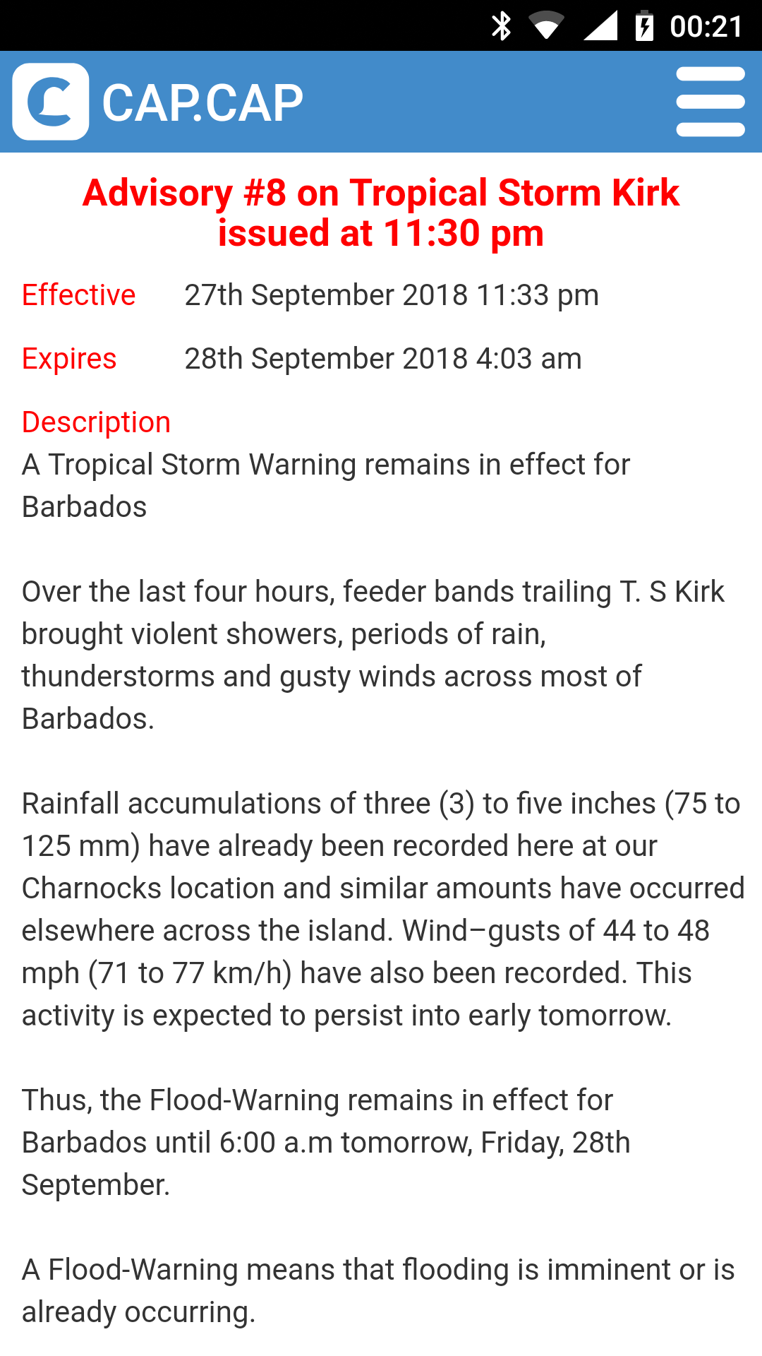
|
Came in late by email, though ...
------- Forwarded Message -------
| Advisory
#8 on Tropical Storm
Kirk issued at 11:30
pm |
| Urgency
/ Severity / Certainty
|
| Expected
/ Moderate /
Observed |
|
St
Andrew
Christ
Church
St
George
St
James
St
John
St
Joseph
St
Lucy
St
Michael
St
Peter
St
Philip
St
Thomas
|
| A
Tropical Storm
Warning remains in
effect for Barbados
Over the last four
hours, feeder bands
trailing T. S Kirk
brought violent
showers, periods of
rain, thunderstorms
and gusty winds
across most of
Barbados. Rainfall
accumulations of
three (3) to five
inches (75 to 125
mm) have already
been recorded here
at our Charnocks
location and similar
amounts have
occurred elsewhere
across the island.
Wind–gusts of 44 to
48 mph (71 to 77
km/h) have also been
recorded. This
activity is expected
to persist into
early tomorrow.
Thus, the
Flood-Warning
remains in effect
for Barbados until
6:00 a.m tomorrow,
Friday, 28th
September. A
Flood-Warning means
that flooding is
imminent or is
already occurring.
Meanwhile, at 11:00
p.m, Tropical Storm
Kirk was located by
an Air Force Reserve
Hurricane Hunter
aircraft near 13.8N
61.4W or about 136
miles ... 220km
northwest of
Barbados.
Maximum sustained
winds remain near 50
mph…85km/h, with
tropical-storm-force
winds extending
outward up to 130
miles (209 km) to
the south-east of
the center.
Movement is toward
the west at 12
mph…19mph but Kirk
is expected to
resume a
west-northwestward
motion early
tomorrow along with
an increase in
forward speed. The
minimum central
pressure was
1002mb…29.59 inches.
Gradual weakening is
forecast as the
system moves into
the eastern
Caribbean Sea.
|
| Residents
in low-lying areas
should remain on the
alert and take all
necessary
precautions to
protect life and
property. |
|
|
|
|
|
|
|
- CAP.CAP
|
- By Jurgen Starck <weather at turtle48.de>
- Date: Fri, 28 Sep 2018 00:25:36 -0400
|
|
|
- For the records
|
- By Jurgen Starck <weather at turtle48.de>
- Date: Fri, 28 Sep 2018 00:21:02 -0400
|
|
The Barbados MET Office just released a CAP.CAP statement, that
3-5 inches (75-125 mm) of rainfall have already been recorded!
Wind gusts between 44-48 mph (71-77 km/h) have been recorded
as well.
CAP.CAP is an app you should have on your smartphones! Look up
Google Play Store or the Apple App Store for it.
It looks like to become a LONG night, too! ;-)
--

Best regards and stay safe.
Jurgen

Barbados South, near airport (BGI)
|
|
|
- As for the rain...
|
- By Jurgen Starck <weather at turtle48.de>
- Date: Thu, 27 Sep 2018 23:22:05 -0400
|
|
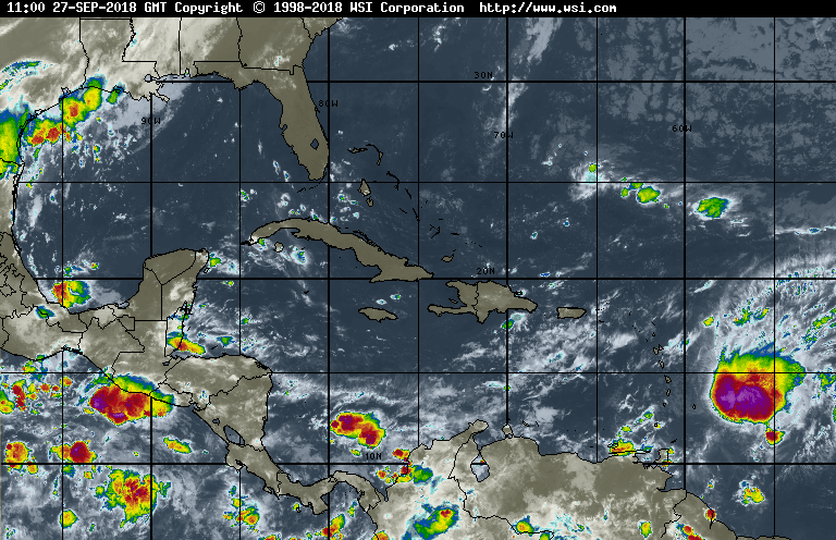
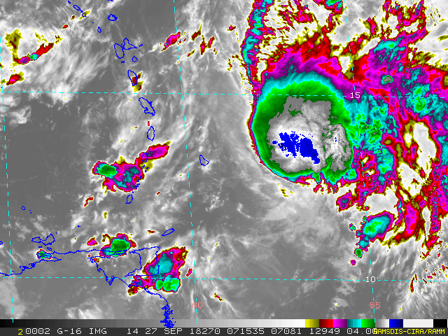
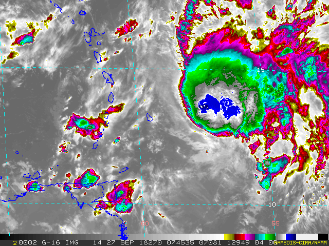
I am sending two satellite photos. They have been taken about 5
hours apart from each other. So, you can make your math! The rain
is falling with different intensity between slight to heavy from
when it started. There was also some thunder and lightning before,
not any more as of the recent 1 - 2 hours.
About 1 hour after this image was taken, the rain began falling
down in Barbados, that was around 18:30 local time:
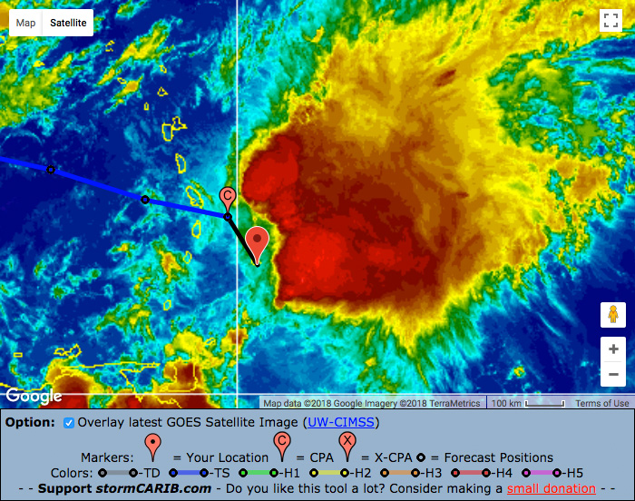
The following image was taken around 22:15 AST. We are not even 20%
through the orange-red area!
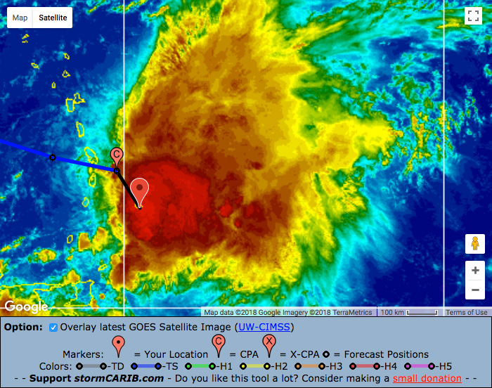
This will last LONG!
--

Best regards and stay safe.
Jurgen

Barbados South, near airport (BGI)
|
|
|
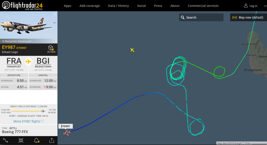
- Believe it or not!
|
- By Jurgen Starck <weather at turtle48.de>
- Date: Thu, 27 Sep 2018 22:09:41 -0400
|
It looks like they have landed in Trinidad. It's amazing that they
haven't run out of fuel during this odyssey! Look at the route they had
to go!
--

Best regards and stay safe.
Jurgen

Barbados South, near airport (BGI)
|
|
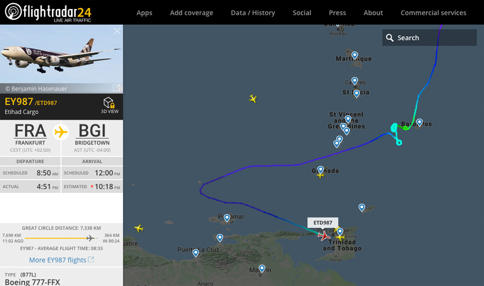
- Believe it or not!
|
- By Jurgen Starck <weather at turtle48.de>
- Date: Thu, 27 Sep 2018 21:59:47 -0400
|
I am hoping they can land down there in Trinidad. It's amazing that they
haven't run out of fuel during this odyssey!
--

Best regards and stay safe.
Jurgen

Barbados South, near airport (BGI)
|
|
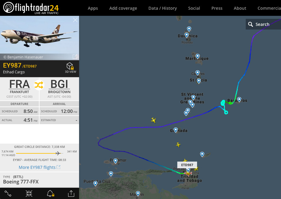
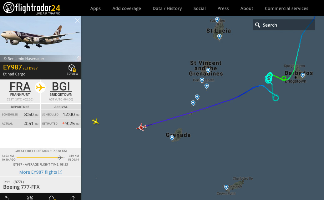
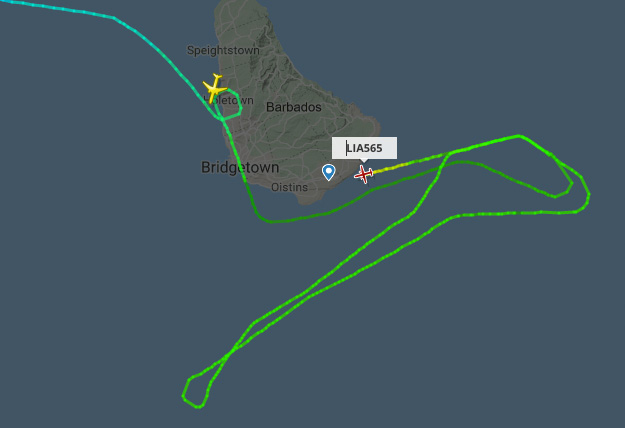
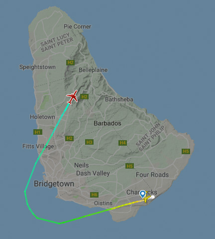
- Runaway flight!
|
- By Jurgen Starck <weather at turtle48.de>
- Date: Thu, 27 Sep 2018 21:16:46 -0400
|
Me again,
I thought I had finished posting for the day, but things turned really
weird! Flight EY 987, an Etihad Cargo plane bound for Barbados, facing a
tough landing! It looks like the Boeing 777 flight had no chance to land
in Barbados! Rain is falling down heavily at this time.
Flightradar24.com says the flight is trying to land somewhere to the
West of Barbados. I can't tell where, though. But as it looks somewhere
very much to the West!
This is one of the strangest weather situations I have ever followed.

--

Best regards and stay safe.
Jurgen

Barbados South, near airport (BGI)
|
|
- Why worry about rain when living in a flight path?!
|
- By Jurgen Starck <weather at turtle48.de>
- Date: Thu, 27 Sep 2018 20:10:28 -0400
|
This can't be for real, but it just happened!

--

Best regards and stay safe.
Jurgen

Barbados South, near airport (BGI)
|
|
- The Rain is here
|
- By Jurgen Starck <weather at turtle48.de>
- Date: Thu, 27 Sep 2018 18:30:39 -0400
|
|
Good evening to all,
as the saying goes: "The party is only over after the fat Lady
has sung!" Well, she has started her song, so to speak, but it
will probably be a long one. A few minutes ago the rain started
falling down. I suppose that is going to last very long due to the
slow speed of the cloud mass.
I am just hoping that most of the water may come down before it
reaches Dominica!
All of you stay safe and dry!
--

Best regards to all.
Jurgen

Barbados South, near airport (BGI)
|
|
|
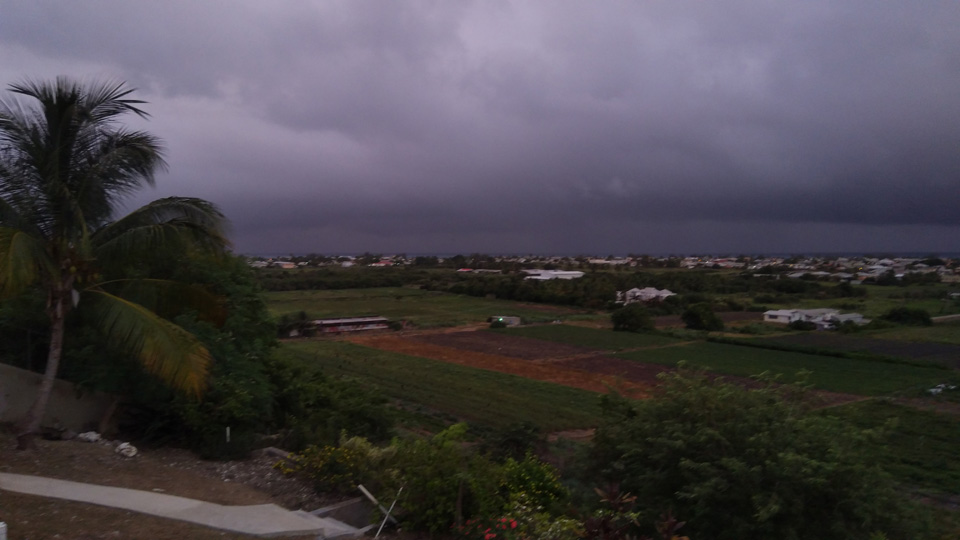
- The Clouds are coming...
|
- By Jurgen Starck <weather at turtle48.de>
- Date: Thu, 27 Sep 2018 17:49:16 -0400
|
I just wanted to share this ...
Satellite 17:10 o'clock:

REAL view from my terrace about the
same time. About 140° Panorama from EAST (left) to SOUTH-WEST
(right). The clouds that TS Kirk has left behind are coming in
very slowly!
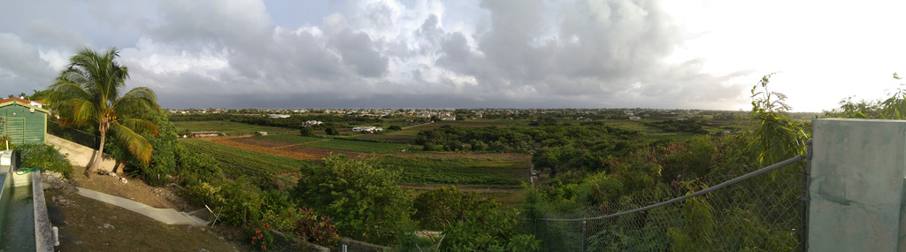
A little later, BA 2154 taking off into the sun.
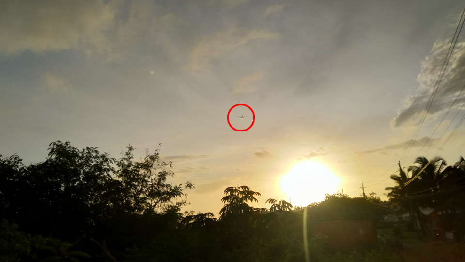
 What a day!
--

Best regards to all.
Jurgen

Barbados South, near airport (BGI)
|
|
|
- Strange development
|
- By Jurgen Starck <weather at turtle48.de>
- Date: Thu, 27 Sep 2018 13:31:51 -0400
|
Hi again,
thanks to a hint from Chris Bolt who posts the Grenada correspondents
page it looks like the centre of TS Kirk has broken away from the cloud
mass, which made Kirk looking virtually stationary. Here is a visible
satellite animation that supports his view:
https://www.star.nesdis.noaa.gov/GOES/sector_band.php?sat=G16§or=taw&band=01&length=48
Here in the South of Barbados everything is quiet. Winds are low but
have changed direction. Planes are taking off to the West, at least some
of them.
Take care everyone.

--

Best regards to all.
Jurgen

Barbados South, near airport (BGI)
|
|
- Kirk stationary?
|
- By Jurgen Starck <weather at turtle48.de>
- Date: Thu, 27 Sep 2018 12:07:55 -0400
|
|
|
|
- It is eerily quiet on the outside. The silence is deafening. Quite warm and not single leaf is moving. We had a few light showers around 8 p.m. on the South Coast and that was about it.
|
- By Stephen Chanderbhan <Novaalas0 at outlook.com>
- Date: Thu, 27 Sep 2018 07:45:56 +0000
|
Sent from
Mail for Windows 10
|
|
|
- light rain
|
- By Stephen Chanderbhan <Novaalas0 at outlook.com>
- Date: Thu, 27 Sep 2018 08:14:11 +0000
|
Sent from
Mail for Windows 10
|
|
|
- TS Kirk at the doorstep
|
- By Jurgen Starck <weather at turtle48.de>
- Date: Wed, 26 Sep 2018 11:29:11 -0400
|
|
--
Best regards to all. Stay safe!
Jurgen
Barbados South, near airport (BGI)
|
|
|
- TS Kirk
|
- By Jurgen Starck <weather at turtle48.de>
- Date: Wed, 26 Sep 2018 11:26:37 -0400
|
|
|
|
- Update
|
- By Stephen Chanderbhan <Novaalas0 at outlook.com>
- Date: Tue, 25 Sep 2018 21:58:04 +0000
|
Sent from
Mail for Windows 10
|
|
|
- My previous report wasn't was finished, sorry
|
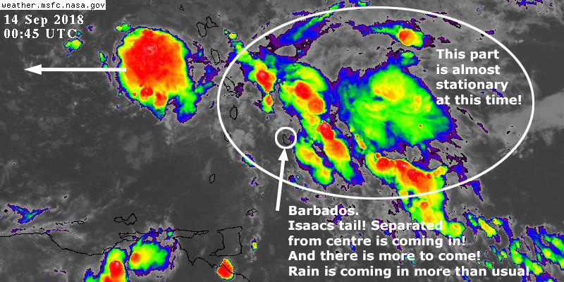
- By Jurgen Starck <weather at turtle48.de>
- Date: Fri, 14 Sep 2018 01:09:14 -0400
|
Sorry, for a premature wrong click, me previous message wasn't meant to
go out when it did, so, her comes the rest of it.
As you can see in the graphic and the links I have posted before. The
centre of Isaac is heading West, whilst the tail is still stationary,
more or less. Compare this to the links in my previous emails, if you
want to.
Here in Barbados the rain is coming back in different intensities every
now and then. Meaning there is more to come! Not too much wind, though.
Be prepared folks! To me it doesn't seem to be over as yet! Talking rain
not winds!
Stay vigilant and safe!
--

Best regards to all.
Jurgen

Barbados South, near airport (BGI)
Attachment:
20180913_The_tail_of_Isaac_has_split_away!.jpg
Description: JPEG image
|
|
- TS Isaac
|
- By Jurgen Starck <weather at turtle48.de>
- Date: Thu, 13 Sep 2018 06:43:28 -0400
|
Good morning,
while the centre of Isaac has passed it's closest point to Barbados here
is still no wind on the ground. The clouds up in the sky are moving
northwards. Two light and short showers between 5:00 and 5:30 am.
Otherwise we are waiting for the southern trail of Isaac to come.
--

Best regards to all.
Jurgen

Barbados South, near airport (BGI)
|
|
- Barbados Warning System Alert - WEATHER INFORMATION STATEMENT FOR Barbados 5:00 pm
|
- By Jurgen Starck <weather at turtle48.de>
- Date: Wed, 12 Sep 2018 18:00:43 -0400
|
|
Good evening to all,
see forwarded email of the Barbados CAP.CAP Warning System below.
Best regards to all.
Jurgen

Barbados South, near airport (BGI)
| WEATHER
INFORMATION
STATEMENT FOR
Barbados 5:00 pm
|
| Urgency
/ Severity / Certainty
|
| Expected
/ Moderate /
Observed |
|
St
Andrew
Christ
Church
St
George
St
James
St
John
St
Joseph
St
Lucy
St
Michael
St
Peter
St
Philip
St
Thomas
|
| The
Barbados
Meteorological
Services continues
to closely monitor
the progress of
Tropical Storm
Isaac over the
Atlantic. NO
TROPICAL
STORM/HURRICANE
WATCHES OR WARNINGS
ARE IN EFFECT FOR
BARBADOS.
At 5:00 p.m, T.S
Isaac was located
near 15.4N 56.6W or
about 250 miles (400
km) east-north east
of Barbados. Maximum
sustained winds are
near 60 mph or 95
km/h. Storm force
winds extend 175
miles (280 km)
primarily to the
north of the center.
Isaac continues to
move westward at 20
mph or 31km/h
On this track, the
center of this
system is forecast
to pass between 100
and 150 miles (160
to 240 km) north of
Barbados early
tomorrow. Some
pockets of moderate
to heavy showers and
occasional gusty
winds are likely
into Friday, with
possible rainfall
accumulations of one
(1) to two (2)
inches.
Some deterioration
in sea conditions
are expected tonight
and will continue
into tomorrow with
swells expected to
peak near 3.5m in
open water. A
Small-Craft Warning
and a High-Surf
Advisory will be in
effect from 6:00
p.m, today until
6:00 a.m Friday,
14th September,
2018.
A small-craft
Warning means in
this case that
surface winds
greater than or
equal to 25 knots
and seas equal to or
greater than 3m
(10ft) are already
affecting or
expected to affect
the marine area.
A High-Surf Advisory
is issued when
breaking wave action
poses or is expected
to pose a threat to
life and property
within the surf
zone.
The BMS will
continue to closely
monitor the progress
of Tropical Storm
Isaac and will
update this
information at 11:00
p.m tonight..
|
| RESIDENTS
IN BARBADOS SHOULD
CONTINUE TO MONITOR
THE PROGRESS OF THIS
SYSTEM. |
|
|
|
|
|
|
|
- CAP Warning System
|
- By Jurgen Starck <weather at turtle48.de>
- Date: Fri, 7 Sep 2018 17:25:59 -0400
|
Advice to all who don't know about it,
the Barbados MET Office and the Barbados Department of Emergency
Management (DEM) are using CAP (Common Alert System) to propagate
information, warnings, alerts etc. to the public via different channels,
like smartphone App, SMS, email, their own website publications and
other media. In urgent cases they might even interrupt radio or TV
broadcasts if necessary and they also transmit via maritime radio
channels, if necessary.
Since many people nowadays are affixed to their smartphones, I would
recommend to install the CAP app. For iPhones look for "CAP" in the App
store, for Android (Google Play store) look for "CAP.CAP" (NOTE the dot
and the repetition of "CAP" for Android!). Once downloaded and installed
follow the instructions and subscribe to any channel you need as to what
they are offering.
This app may be also useful for users in surrounding islands. However, I
am not able to confirm, if other islands would be able to receive alerts
coming from Barbados. So, please don't blame me if it doesn't because I
had no chance to test it. May be someone from another island can help to
confirm or deny by emailing me. I really would appreciate it. In the
meantime I may post further incoming post from CAP by posting their
links as shown below. Check this page every now and then and compare
with what you've received.
Please, forward this msg to fellow Caribbean friends you know on other
islands, because I don't know many people over there.
May be Gert can help with this too?
Two "rollers" are coming our way now and may be this CAP app could help!
CAP has just sent out an informational msg a few minutes ago. You can
read it here:
https://brb-primary.capews.com/capews/public/alert/view/ZGJ3DgAKBBAaW38GRwZ1QUJ9fn5USAhIZA==.
May everybody be prepared and stay safe! Fingers crossed.
--

Best regards to all.
Jurgen

Barbados South, near airport (BGI)
|
|
- Squally weather!
|
- By Stephen Chanderbhan <Novaalas0 at outlook.com>
- Date: Sat, 18 Aug 2018 05:27:35 +0000
|
It’s really coming down on the south coast as of 1:00 a.m. Thunder and Lightning with heavy rain.
Sent from
Mail for Windows 10
|
|
|
- Beryl shows its tail
|
- By Jurgen Starck <weather at turtle48.de>
- Date: Mon, 9 Jul 2018 04:50:07 -0400
|
Good morning to all,
at the time when Beryl was supposed to be nearest to Barbados yesterday
there was not one leave shaking on the trees and no rain whatsoever. We
had a few showers in the morning before Beryl was forecasted to get
close, but according to satellite photos at that time they were not
related to Beryl, just the usual rain. Now, since 3:00am today I am
hearing thunder in the distance, some rare lightning going with it
lately and the rain is coming down lightly with that constant sound that
it may never end doing so. Just now as I am writing this heavy lightning
and thunder is repeatedly occurring, 20 seconds between lightning and
thunder, meaning it happened about 6+ kilometres away from my location
(see below). I am assuming to the north from here. Rain still falling
constantly but lightly.
I am just hoping that Dominica was spared from the worst, because they
really did not need another disaster for sure!
Everyone may be prepared and stay safe.

--

Best regards to all.
Jurgen

Barbados South, near airport (BGI)
|
|
- High-Winds warning
|
- By Jurgen Starck <weather at turtle48.de>
- Date: Fri, 22 Jun 2018 20:02:04 -0400
|
Good evening everyone,
effective tomorrow morning, Saturday 23rd June 2018, 6:00am, the
Barbados MET Office has issued "A High-Wind and Small-Craft Warning for
Barbados".
See here:
http://barbadosweather.org/MT-Warnings-tbpb.php?PlanetOfApes=1529711405.
Be careful and stay safe!

--

Best regards to all.
Jurgen

Barbados South, near airport (BGI)
|
|
