|
|
- - - 2018 Hurricane Season - - -
|
- STORM OSCAR
|
- By Martha Watkins Gilkes <marthawatkinsgilkes at gmail.com>
- Date: Sun, 11 Nov 2018 20:59:57 -0400
|
AGAIN     we  are     all eyes  to the  east!!  As   TROPICAL STORM  OSCAR has
developed   just when  we    were  letting our  guard  down   and    thinking
IT  IS  OVER…     Thinking and  hoping it will   veer NORTH.  but  lets  stay
alert.
|
|
- Storm watching.
|
- By Martha Watkins Gilkes <marthawatkinsgilkes at gmail.com>
- Date: Wed, 26 Sep 2018 07:51:37 -0400
|
Once Again.  Eyes to the east as we watch Storm Kirk.  Seems it will stay south
of Antigua.
|
|
- After the storm
|
- By Martha Watkins Gilkes <marthawatkinsgilkes at gmail.com>
- Date: Fri, 14 Sep 2018 06:14:03 -0400
|
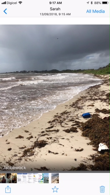
After the storm.     Early morning sunrise 🌅 over Half moon bay.  The waves 🌊
quite big looking from top of the peak  but good thing to clean the beach of
sargassum weed.   And some odd cumulus clouds hanging around.   But soon back
to our beautiful Caribbean weather.    And hardly a flower lost in my beloved
garden.  The weather gods were kind to us.   Anxious to know how Dominica
fared. 🙏


Martha Watkins Gilkes
P.O. Box W1924
Antigua, West Indies
268 460 4423
Cell 2687647722
Sent from my  fab iPhone
Marthawatkinsgilkes at gmail.com
|
|
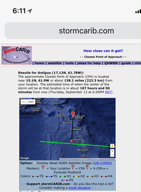
- Screenshot 2018-09-13 at 9.17.51 AM
|
- By John Fuller <fullaw at candw.ag>
- Date: Thu, 13 Sep 2018 09:19:06 -0400
|
North coast
Sent from my iPhone
|
|
- 7 am STORM ISAAC
|
- By Martha Watkins Gilkes <marthawatkinsgilkes at gmail.com>
- Date: Thu, 13 Sep 2018 07:30:22 -0400
|
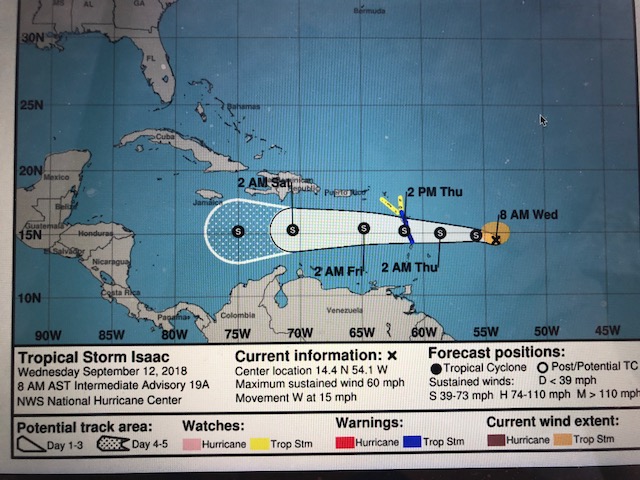
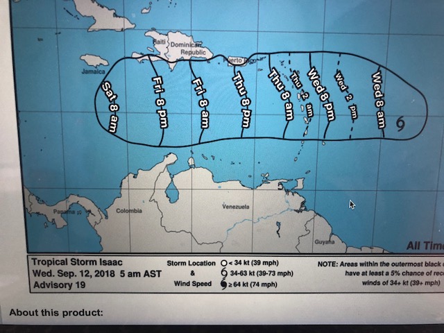
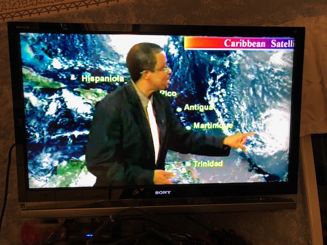
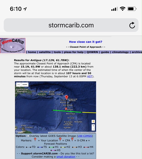
As we wake up this morn it is gusty but certainly NO HURRICANE… Our Met office has just advised Storm Isaac is around 45 MPH with higher gusts and is now 107 miles off us as you can see in this sat photo ( the live version of this was posted for you to see yesterday ) The system is moving at 17 mph which puts the center around 6 hours away so Met Office says we will get worst of gusts between now and mid late afternoon… up to perhaps 50 MPH gusts if in a windy area. We will get an update at 8 am but expect the same as here. LIAT - our regional airline has a travel advisory on their web site - check there for details… Travel Advisory #4
FOR IMMEDIATE RELEASE
FLIGHTS DISRUPTIONS DUE TO TROPICAL STORM ISAAC
LIAT wishes to advise passengers that due to the passage of Tropical Storm Isaac that several destinations within the LIAT network will be affected. In the interest of passenger and crew safety, several flights have been cancelled and retimed.
ALL IN ALL Antigua is very very lucky with this system … THINKING OF DOMINICA as the system will go over the island in a few hours. I hope all are safe there. Sure hope this is the LAST SYSTEM WE SEE this hurricane season but we are in the height of the season ( SEPTEMBER MONTH)
THINKING OF ALL IN THE PATH of HURRICANE FLORENCE and thankful it is now a CAT 2 but still very DANGEROUS. 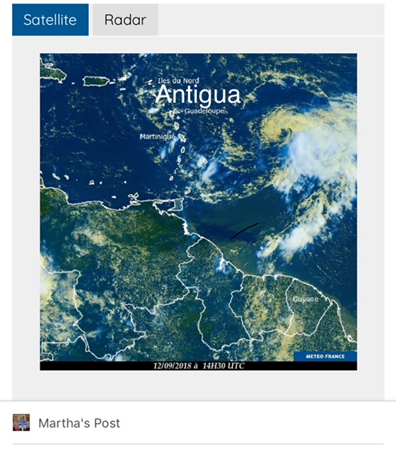 Martha Watkins Gilkes P.O. Box W1924 Antigua, West Indies 268 460 4423 Cell 2687647722 Sent from my fab iPhone Marthawatkinsgilkes at gmail.com |
|
|
- Isaac
|
- By John Fuller <fullaw at candw.ag>
- Date: Wed, 12 Sep 2018 23:12:08 -0400
|
Breeze freshening from NE. May get closer than anticipated.
Sent from my iPhone
|
|
- Live satellite coming at us.
|
- By Martha Watkins Gilkes <marthawatkinsgilkes at gmail.com>
- Date: Wed, 12 Sep 2018 22:25:07 -0400
|
|
|
|
- TS Isaac
|
- By Daniella Seepaul <daniellaseepaul at gmail.com>
- Date: Wed, 12 Sep 2018 11:35:59 -0400
|
Hi Fellow Islanders,
As we wait on Tropical Storm Isaac to pass over portions of the islands, i hope that all is prepared, its always better to hope for best and prepare for the worst.
My heart goes out to Dominica who suffered from the impacts of Hurricane Maria last year. Hoping we all just get a little rain and very little squally weather.
Stay safe fellow islanders.
Regards,
Daniella Seepaul |
|
- Storm this morning
|
- By Martha Watkins Gilkes <marthawatkinsgilkes at gmail.com>
- Date: Wed, 12 Sep 2018 10:21:38 -0400
|
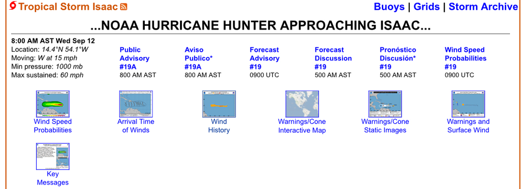
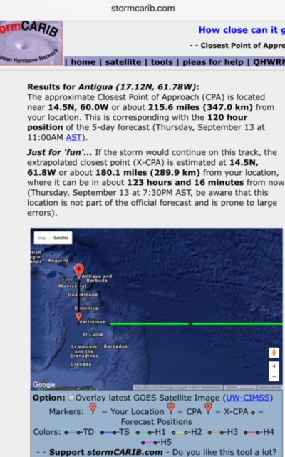
Hurricane watching.   Actually. Thank goodness. Tropical Storm watching.   As
of 8 am the Hurricane hunters we’re heading for the Storm.  See their plan of
the day below.  1130 Zulu or 730 am.  Storm 430 miles to the east.   Should be
over the islands Around Thursday morning.  So we wait for the Hunters. Report
to decide on shutters and moving things.    If it stays south Antigua will get
very little.      Regardless Thinking of those more in the path and especially
hurricane Florence that is very serious.
Martha Watkins Gilkes
P.O. Box W1924
Antigua, West Indies
268 460 4423
Cell 2687647722
Sent from my  fab iPhone
Marthawatkinsgilkes at gmail.com
|
|
- Hurricane update
|
- By Martha Watkins Gilkes <marthawatkinsgilkes at gmail.com>
- Date: Wed, 12 Sep 2018 05:23:30 -0400
|
Tuesday night.  Hurricane update.   We are watching.     LIat. Our regional
airline has cancelled a number of flights.   a short video  below ... this is
our local forecast summary.      It seems ANTIGUA will be lucky again but
tomorrow after the hurricane hunters fly it I will make s final decision on
putting up the big metal hurricane shutters.
Meanwhile the air is totally calm and this early morn my rescue pigeon  flew in
to join me for breakfast     Almost like he knows there is something in the air
😱🌪.   Tomorrow we will know more on what we will face. Although we know it
changes.     So thinking of Dominica and praying they are spared.    this
hurricane thing is not for sissies.

|
|
- Hurricane update.
|
- By Martha Watkins Gilkes <marthawatkinsgilkes at gmail.com>
- Date: Tue, 11 Sep 2018 10:41:48 -0400
|
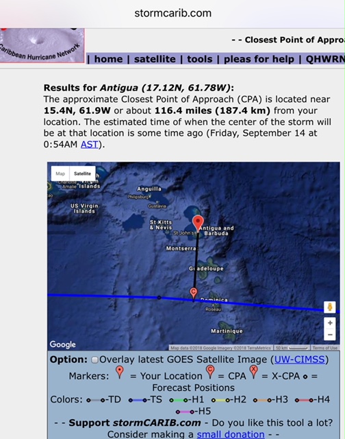
Hurricane up date.   The track is a bit closer to us. 116 miles.    But. Now a
Strong Tropical storm with 70 mile winds.    But excepted to be a hurricane
again when it reaches the islands.      Still watching if it  is moving north
to put up hurricane shutters.
|
|
- Track coming nearer
|
- By Martha Watkins Gilkes <marthawatkinsgilkes at gmail.com>
- Date: Mon, 10 Sep 2018 21:43:47 -0400
|
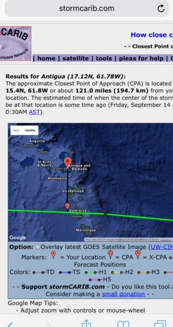
Now 121 miles from Antigua. Creeping north. We need to watch.
Martha Watkins Gilkes
P.O. Box W1924
Antigua, West Indies
268 460 4423
Cell 2687647722
Sent from my  fab iPhone
Marthawatkinsgilkes at gmail.com
|
|
- Sunday morning
|
- By Martha Watkins Gilkes <marthawatkinsgilkes at gmail.com>
- Date: Sun, 9 Sep 2018 06:27:44 -0400
|
On this early Sunday morning the Proposed track for What will  surely be
Hurricane Isaac puts it to ANTIGUAs south  by 138 miles.  But we know how these
tracks change  (last year as Irma was heading dead on to Antigua it shifted
north by 35 miles and hit Barbuda instead). so it is early days to predict this
.
Martha Watkins Gilkes
P.O. Box W1924
Antigua, West Indies
268 460 4423
Cell 2687647722
Sent from my  fab iPhone
Marthawatkinsgilkes at gmail.com
|
|
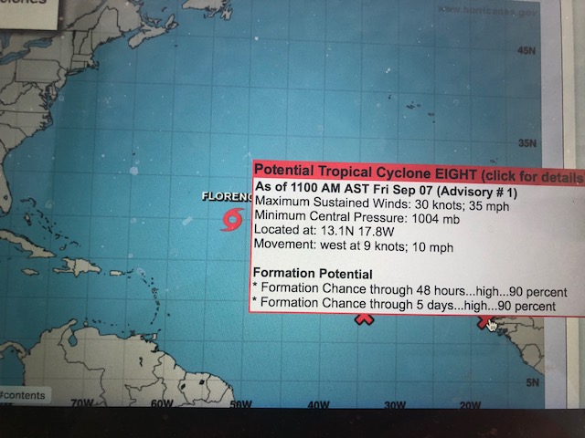
- Hurricane Hunters to Fly the Storms
|
- By Martha Watkins Gilkes <marthawatkinsgilkes at gmail.com>
- Date: Sat, 8 Sep 2018 18:47:29 -0400
|
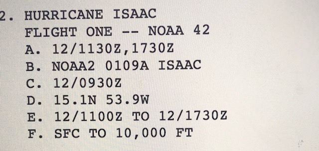
THE HURRICANE HUNTERS PLANS for flying the storms
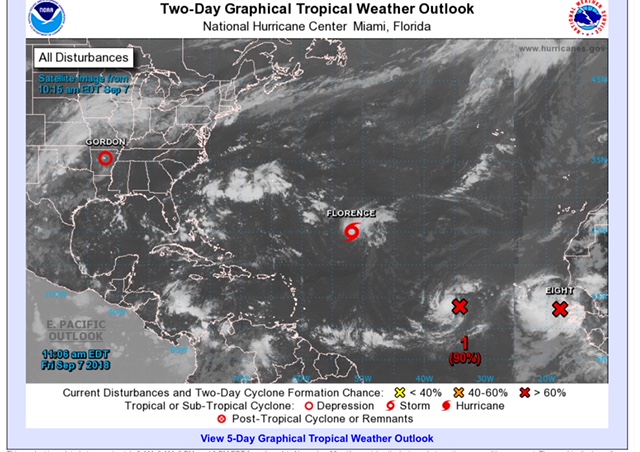
The information we are given on the storms is MUCH MORE ACCURATE once the HURRICANE HUNTERS start flying the systems and get much more accurate data on wind speed and direction, pressure etc. SO glad to see on the bottom ( In red) they will be flying TD 9 ( NOW NAMED TS ISAAC) so as the system gets closer to the islands we will be getting more accurate information.
ALL EYES ARE ON FLORENCE as this will most likely hit the US COAST so of course there is great concern. But TD 9 ( just named TS ISAAC) will be flown soon.
112
NOUS42 KNHC 081648
REPRPD
WEATHER RECONNAISSANCE FLIGHTS
CARCAH, NATIONAL HURRICANE CENTER, MIAMI, FL.
1245 PM EDT SAT 08 SEPTEMBER 2018
SUBJECT: TROPICAL CYCLONE PLAN OF THE DAY (TCPOD)
         VALID 09/1100Z TO 10/1100Z SEPTEMBER 2018
         TCPOD NUMBER.....18-107

I.  ATLANTIC REQUIREMENTS
    1. TROPICAL STORM FLORENCE
       FLIGHT ONE -- NOAA 49         FLIGHT TWO -- NOAA 49
       A. 10/0000Z                   A. 10/1200Z
       B. NOAA9 0206A FLORENCE       B. NOAA9 0306A FLORENCE
       C. 09/1730Z                   C. 10/0530Z
       D. NA                         D. NA
       E. NA                         E. NA
       F. 41,000 TO 45,000 FT        F. 41,000 TO 45,000 FT

    2. OUTLOOK FOR SUCCEEDING DAY:
       A. BEGIN 12-HRLY FIXES ON FLORENCE AT 10/2330Z NEAR
          25.6N 61.8W.
       B. NOAA 49 G-IV SYNOPTIC SURVEILLANCE MISSIONS AROUND
          FLORENCE FOR 11/0000Z AND 11/1200Z DEPARTING KLAL AT
          10/1730Z AND 11/0530Z.
3. ADDITIONAL DAY OUTLOOK: BEGIN 6-HRLY FIXES ON TROPICAL DEPRESSION NINE AT 12/1130Z.
|
|
|
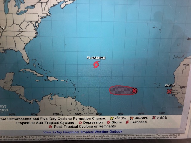
- Possible hurricane coming our way
|
- By Martha Watkins Gilkes <marthawatkinsgilkes at gmail.com>
- Date: Sat, 8 Sep 2018 16:45:36 -0400
|
Suddenly the Atlantic has become active and we may have a hurricane on us mid
week ..., shows track to south but we all know they often turn north so have to
keep a close eye on this. Will start with general things. “Getting ready “
tomorrow. none of our islands deserve this after last year so hope for the
best but plan for the worst
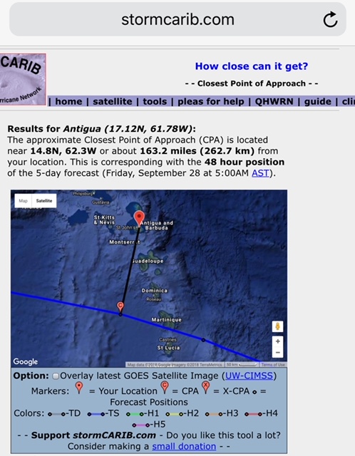
Thanks Gert of Stormcarib.com for keeping us posted.
|
|
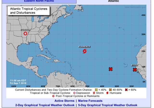
- Hurricane season warming up
|
- By Martha Watkins Gilkes <marthawatkinsgilkes at gmail.com>
- Date: Fri, 7 Sep 2018 13:38:16 -0400
|
We are watching some active spots out in the Atlantic now. And hoping for a
north turn as they come closer.   Early  days but worth watching.
|
|
- Active September
|
- By Daniella Seepaul <daniellaseepaul at gmail.com>
- Date: Thu, 30 Aug 2018 12:40:03 -0400
|
|
Hi Fellow Islanders,
What a lovely rainny couple of days we're having here in Antigua! We're so greatful for this supply from mother Nature.
That being said, we must remember that we're entering the peak of the hurricane season and we all must be prepared.
NHC have issued advisories for Potential Tropical Cyclone six, which is expected to develop into a tropical storm and then into a hurricane, and forcasted to head up into the north Atlantic ocean and remain a fish storm. Forecast models show however that possibly two more system may develop after in the Atlantic. Even though the start of the season was slow thanks to cooler water temps, Saharan dust, and wind shear, we do expect the season to get more active.
We must not let our guards down.
Lets be prepared. Remember it only takes one!
Regards,
Daniella Seepaul
|
|
- Hurricane Update
|
- By Martha Watkins Gilkes <marthawatkinsgilkes at gmail.com>
- Date: Wed, 8 Aug 2018 07:41:15 -0400
|
|
|
|
- Weather in ANTIGUA
|
- By Martha Watkins Gilkes <marthawatkinsgilkes at gmail.com>
- Date: Mon, 9 Jul 2018 06:21:50 -0400
|
Although the hurricane broke up  and was downgraded and was quiet far south we
had a stormy night and an overcast morning now that will slowly break.  We did
get a bit of rain but not nearly enough given our drought conditions.    Of
course the hurricane season has just started so we will be very watchful.
|
|
- NO HURRICANE COMING HURRAY
|
- By Martha Watkins Gilkes <marthawatkinsgilkes at gmail.com>
- Date: Sat, 7 Jul 2018 12:10:22 -0400
|
ANTIGUA… LUCKY ONCE AGAIN!! BERYL IS DYING !!!! and Thankful for the other islands too especially Dominica…….. 11:00 AM July 7th - As expected, Beryl has been downgraded to a Tropical Storm as of the latest advisory.......Further weakening is anticipated
According to the NHC's latest discussion on the system, Beryl's small size was always going to make it prone to wild and unpredictable fluctuations in intensity, and that appears to have come to fruition this morning. The cyclone's low-level center is now completely exposed with all associated deep convection displaced to the east and southeast......See attached close up images.
LOCATION...12.1N 51.1W
ABOUT 720 MILES ESE OF THE LESSER ANTILLES
MAXIMUM SUSTAINED WINDS...65 MPH
PRESENT MOVEMENT...WNW OR 295 DEGREES AT 14 MPH
MINIMUM CENTRAL PRESSURE...999 MB
At 1100 AM AST, the center of Tropical Storm Beryl was
located near latitude 12.1 North, longitude 51.1 West. Beryl is moving toward the west-northwest near 14 mph. A west-
northwestward motion with an increase in forward speed is expected during the next few days. On the forecast track, the center of Beryl will approach the Lesser Antilles over the weekend, cross the island chain late Sunday or Monday, and move south of the Virgin Islands and Puerto Rico on Monday and Monday night.
Maximum sustained winds have decreased to near 65 mph
with higher gusts. Additional weakening is forecast during the next 48 hours.
Beryl is a small tropical storm. Tropical-storm-force winds extend outward up to 35 miles.
Key Messages:
1. Beryl is no longer forecast to be near hurricane strength when it approaches the Lesser Antilles Sunday night or Monday, but the chance of some islands receiving direct impacts from wind and rainfall continues. Tropical storm warnings and watches are in effect for some of the countries in the Lesser Antilles, and additional watches or warnings could be required for other islands later today.
2. Due to its very small size, there is greater-than-usual
uncertainty in the analysis of Beryl's current intensity, and
confidence in the official intensity forecast is also lower than normal. Rapid changes in intensity, both up and down, that are difficult to predict are possible during the next couple of days. |
|
|
- Hurricane coming
|
- By Martha Watkins Gilkes <marthawatkinsgilkes at gmail.com>
- Date: Fri, 6 Jul 2018 14:05:38 -0400
|
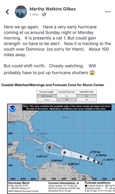
Martha Watkins Gilkes
P.O. Box W1924
Antigua, West Indies
268 460 4423
Cell 2687647722
Sent from my  fab iPhone
Marthawatkinsgilkes at gmail.com
|
|
- beryl
|
- By John Fuller <fullaw at candw.ag>
- Date: Fri, 6 Jul 2018 13:59:27 -0400
|
Here we go again. Hoping for some rain.
Sent from my iPhone
|
|
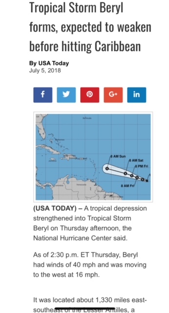
- Tropical Storm Beryl
|
- By Martha Watkins Gilkes <marthawatkinsgilkes at gmail.com>
- Date: Thu, 5 Jul 2018 16:21:38 -0400
|
Looks like we will be lucky. Maybe some rain ☔️ we hope
|
|
- 95L
|
- By Daniella Seepaul <daniellaseepaul at gmail.com>
- Date: Thu, 5 Jul 2018 09:31:35 -0400
|
Hi Islanders,
As our first invest 95L in the Atlantic draws near, we in Antigua also hope to benefit some much needed rain.
According to NHC, 95L is expected to become a tropical depression at anytime and then forecasted to degenerate into a trough before it approaches us.
All eyes on 95L.
Regards, Daniella Seepaul |
|
- Better Forecast for upcoming Hurricane season!
|
- By Martha Watkins Gilkes <marthawatkinsgilkes at gmail.com>
- Date: Sun, 24 Jun 2018 07:52:54 -0400
|
link
|
|
- First named storm
|
- By Martha Watkins Gilkes <marthawatkinsgilkes at gmail.com>
- Date: Sun, 27 May 2018 06:33:04 -0400
|
Not even official start of hurricane season and we have the first named storm
to track up the Florida west coast.   Heads up

Martha Watkins Gilkes
|
|
- UPCOMING 2018 HURRICANE SEASON
|
- By Martha Watkins Gilkes <marthawatkinsgilkes at gmail.com>
- Date: Wed, 11 Apr 2018 14:03:38 -0400
|
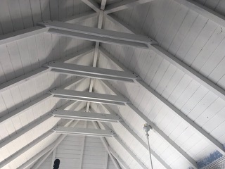
For those of us in the islands we are always tuned in to HURRICANE SEASON and although it is still several months away from OFFICIAL START we are watching the forecasts.. Here is one from our Antigua MET OFFICE … should have us all doing things NOW. as i have been.. I learned that putting CROSS BEAMS across your roof greatly protects it from being “GONE WITH THE WIND” so have now ties all 8 of my roofs like this…. photos to show
FORECAST FOR 2018
ROOF BEFORE CROSS TIES . 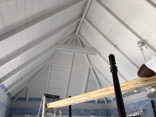
ROOF AFTER CROSS TIES making it much stronger in a hurricane!
|
|
|
- Active Hurricane Season Ahead!
|
- By Daniella Seepaul <daniellaseepaul at gmail.com>
- Date: Thu, 05 Apr 2018 21:16:11 +0000
|
Dear Fellow Islanders,According to Colorado State University the 2018 hurricane season is expected to be more active than usual. Current predictions are 14 named tropical storms, 7 hurricanes, and 3 major hurricanes. That being said, it's never to early to start planning and preparing for the season ahead.
Regards, Daniella Seepaul
|
|