|
|
- - - 2016 Hurricane Season - - -
|
- Nice weather
|
- By Richard Pierre <realwedda at gmail.com>
- Date: Fri, 9 Dec 2016 14:29:07 -0400
|
|
After the rain yesterday we have a cloudy windy day. Temperatures are bearable. The system that gave us the rain has moved west of us.
|
|
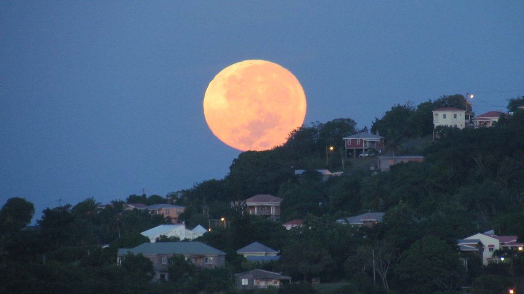
- Clear skies and a Super Moon over Marian
|
- By Christopher Bolt <gommier at gmail.com>
- Date: Mon, 14 Nov 2016 06:38:24 -0400
|
This morning, just before Sunrise, I took a photo of the Super Moon
setting behind Marian. A really clear sky.
Tonight will be a good time to watch a Super Moon rising, just after
6pm, unless an area of cloud and rain, which is associated with a weak
wave about 300 miles to our East, moves in.
Sunset this evening is at about 17:39 (5.39pm)**, Moonrise is about
18:04 (6.04pm), if you want to see a Super Moon and if you have a clear
view to the horizon.
** another interesting thing about sunset is that we are at about the
time of year when the Sun sets at it's earliest, from a few days time it
will start to set later. The evenings will stay brighter longer. This
is not true for the mornings, they will get darker for another two months!
Hogan

You have been sent 1 picture.

IMG_4153.JPG

These pictures were sent with Picasa, from Google.
Try it out here: http://picasa.google.com/
Attachment:
IMG_4153.JPG
Description: JPEG image
|
|
- A big blob of rain to our east
|
- By Christopher Bolt <gommier at gmail.com>
- Date: Sat, 5 Nov 2016 07:50:30 -0400
|
Good morning,
We had some, well needed, heavy rain during the night. This morning it
is cloudy to the East and blue sky to the West, with a wind from the
East to North-East.
Looking at satellite and radar images there is a large area of rain
which spreads from just east of us to way beyond Barbados, where I
believe they are having heavy rain. The size of this blob is pulsating,
and we are right on the edge of it. But unlike normal weather (I think I
have forgotten what that is) it seems to be almost static, with maybe a
slight drift to the north. The Martinique radar shows the rain moving
away from us, at the moment.
See
http://www.meteofrance.gp/previsions-meteo-antilles-guyane/animation/radar/antilles
for the latest radar image.
It was definitely a much cooler night, maybe a slight change in the
weather, cooler?
Have a good weekend

Hogan
|
|
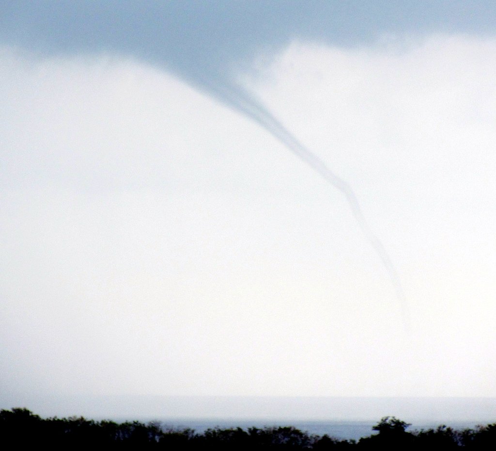
- Thunder and a waterspout
|
- By Christopher Bolt <gommier at gmail.com>
- Date: Thu, 3 Nov 2016 10:50:04 -0400
|
Has been thundering all morning. Only a little rain. But saw this
waterspout. Very short lived (about 4 minutes).
Hogan

You have been sent 1 picture.

IMG_3838.JPG

These pictures were sent with Picasa, from Google.
Try it out here: http://picasa.google.com/
Attachment:
IMG_3838.JPG
Description: JPEG image
|
|
- Rumbling just off to the West.
|
- By Christopher Bolt <gommier at gmail.com>
- Date: Thu, 3 Nov 2016 07:48:11 -0400
|
Flooding and landslides to the North yesterday and absolutely no rain
down South!
This morning I woke to find the ground was damp, that is all.
Over the last hour I have heard rumbling off to the West. Looking at the
radar there is a blob just a few miles off the West coast. It does seem
to be trying to track NE, but struggling. But suggest Stalker, you keep
an eye on the Martinique radar -
http://www.meteofrance.gp/previsions-meteo-antilles-guyane/animation/radar/antilles
to see if it moves in your direction.
All the best

Hogan
|
|
- Island of two halves!
|
- By Christopher Bolt <gommier at gmail.com>
- Date: Wed, 2 Nov 2016 08:51:20 -0400
|
I have just received the following from Stalker (Bathway):

Massive rain!  Mother of a thunderstorm...still going on!  Rain drowning the
plants!
You can have the lot!  Bloody thing not moving on!
All overhead!  Dogs petrified, except the poodle!  Guttering breaking with
strength of rain...

Now compare that with down here in Westerhall:

Sun is shining, although a bit hazy. No rain all night, although there was
lightning and distant thunder. A slight breeze from the SSE and the sound of
thunder north of us (probably coming from the Bathway direction).

For those of you who don't know Grenada, Bathway is only about 16 miles from
Westerhall (as the crow flies). Yet we have two different weather systems, as
past posts on Stormcarib have shown.

Sally doesn't want any more rain and we want it.

There is a small "Low" to the NNW of us, which is possibly the source of the
weather, causing a more southerly element to the wind. I guess this is sucking moist air
over the mountains and dropping it further north. The radar and satellite images show
plenty of rain up in the Leewards, and there does appear to be a slight movement south.

Hope the rain stops for you - 'upnorth'.
Just had the closest thunder so far, but no rain, yet!

Have a good day all.

Hogan
|
|
- 10:30 pm and it is hot!
|
- By Christopher Bolt <gommier at gmail.com>
- Date: Tue, 1 Nov 2016 22:45:46 -0400
|
There has been no rain to speak of for weeks now. There is hardly a
breeze. The airport says it is 29C. It feels every bit of it.
I just stood outside so I could cool off before going to bed - it didn't
work. I did notice some distant flashes coming from the north, so
someone somewhere further up the island chain is getting some rain, but
not here. Looking at the radar it seems to have spread down towards St
Lucia. Could it come this far, we can only hope.
Good night all, or will it be Good morning to those that have already
gone to bed. I doubt if they will sleep well, unless they have AC.
Hogan
|
|
- Tropical wave passing through
|
- By Christopher Bolt <gommier at gmail.com>
- Date: Thu, 6 Oct 2016 07:40:33 -0400
|
Hi all,
a lovely morning here, slight breeze, blue skies with just a few clouds
scraping the top of the mountains. Difficult to believe that the
tropical wave is moving through the area. The only sign of it on
Martinque radar is what appears heavy showers approaching the Barbados
area. Barbados radar is still not working so cannot see very far to the
east. The satellite image is showing some big convection, also just to
the east of Barbados. It NHC are showing a disturbance east of Barbados.
I am guessing that any rain will pass through the Grenada area, later
today or Friday.
Have a good day

Hogan
|
|
- The tropical wave.
|
- By Christopher Bolt <gommier at gmail.com>
- Date: Wed, 5 Oct 2016 09:34:42 -0400
|
The activity in the tropical wave has subsided a bit, for the time. What
there is seems to have moved further north. NHC are still giving it a
10% chance in next 48 hours.
The Martinique radar is showing very little rain in the area and the
Barbados radar which would show weather further East is still showing
data which is 4 days old.
Pleasant day today. Hope there is no rain when my friend arrives on the
BA plane today, currently running a few minutes late.
All the best.

Hogan
|
|
- The NHC are now giving the tropical wave some possible development/
|
- By Christopher Bolt <gommier at gmail.com>
- Date: Tue, 4 Oct 2016 18:22:18 -0400
|
I have been watching this wave for some time and thought it seemed to be
having big showers associated with it. The NHC has now given it a 10%
chance of developing in the next 48 hours, with 20% in 5 days. The path
seems to be similar to Matthew, at least until mid Caribbean.
So the chance of rain showers here in Grenada and the other Windward
islands,looks like increasing over the next 48 hours.
Matthew is now over Easter tip of Cuba. Jamaica seems to have come off
lightly. Can't say the same for Haiti which still seems to be getting
rain dumped on it.
Hogan
|
|
- A large area of what looks like heavy rain approaching?
|
- By Christopher Bolt <gommier at gmail.com>
- Date: Tue, 4 Oct 2016 06:13:39 -0400
|
Good morning Grenada.

Hurricane Matthew is battering Haiti (the eye is just approaching the SW
tip of it) and Jamaica seems to be coming off not too bad as far as I
can see.

But now I am looking out to our east. I can see a very large area of
what to me looks like heavy rain. It is embedded in a tropical wave with
the leading edge of rain about 350 miles away. Apart from the following
statement from NHC, it does not appear to be a tropical depression risk
as yet:

Wave is moving through an area
between two upper ridges enhancing clusters of scattered
moderate to isolated strong convection covers the area from
7N-16N between 40W-56W.

A look at the latest satellite images shows the area clearly:
http://www.ssd.noaa.gov/goes/east/tatl/flash-avn.html

If this continues it looks like a some wet weather tomorrow? But I am waiting
to hear what the experts say.

Have a nice day.

Hogan
|
|
- Our thoughts and prayers are with you...
|
- By Sally Stalker <stalker at spiceisle.com>
- Date: Sun, 2 Oct 2016 22:22:13 -0400
|
What is there to say?  We in Grenada know what is bearing down on Jamaica and
Haiti.  How much more can the people of Haiti take?  It is heartbreaking!
Our thoughts and prayers are with you all...

Sent from my iPad
|
|
- Well where did that come from?
|
- By Christopher Bolt <gommier at gmail.com>
- Date: Sun, 2 Oct 2016 16:02:04 -0400
|
Well, we have just had some heavy rain, and we are still getting
thunder. The strange thing is this has come up from the South - very
unusual. It didn't help that I was watching Barbados radar and hadn't
noticed that it has not updated since yesterday!!!
The first I noticed something strange was a line or street of dark
clouds stretching from SE to NW, then the first rumble of thunder. The
street of cloud appeared to move towards us from the West, not our usual
direction for weather. I have just found that we are in a weak tropical
wave, probably linked to 98L NE of the Lesser Antilles. Also spotted
that the next tropical wave at 40W has a 'Low' marked at 10N on the
Synopsis chart. With a movement due West. I can't see any significant
convection associated with it yet, but I will monitor it.
As for Matthew, well it seems to be doing what it says on the box - It
looks as if it will be nearer to Haiti than Jamaica, but looks like they
will get some 'weather' in Jamaica, but Haiti looks like it will get a
battering.
Well at least my tank is full again!

Hogan
|
|
- Matthew aiming near Haiti
|
- By Christopher Bolt <gommier at gmail.com>
- Date: Sun, 2 Oct 2016 07:26:25 -0400
|
Matthew which left our shores as a TS is now heading for the area of
Haiti/Jamaica as a Cat 3/4 having been briefly been a cat 5 for a while.
Our best hopes and prayers go out to the people of Eastern Jamaica and
Haiti.
There is a small low pressure system (98L) which is of no threat to us,
but could affect Bermuda.
Here in Grenada we have a lovely morning, with a hazy blue sky with just
a few clouds. A nice breeze from the East-South-East. The radar shows
just a few fast moving small showers between us and Barbados. The
satellite images don't show any significant clouds this side of the
Atlantic. The synopsis chart shows a weak tropical wave in mid Atlantic,
but that does not appear to be a threat at this stage.
Have a nice Sunday. We have prepare for visitors later in the week.

Hogan
|
|
- Te Sun is out at last -
|
- By Christopher Bolt <gommier at gmail.com>
- Date: Fri, 30 Sep 2016 10:31:51 -0400
|
It is a lovely day here at last.
Hurricane Matthew is travelling West through the Caribbean, but by the
models show a sharp turn North, with Jamaica in it's path, and it is
picking up strength. We wish all our friends in Jamaica and then Cuba
all the best for Monday (expected arrival).
A special personal best wishes to two friends Karen & Carmen (plus her
mum) in Jamaica.
Hogan
|
|
- Matthew not leaving the area without a last minute fight
|
- By Christopher Bolt <gommier at gmail.com>
- Date: Thu, 29 Sep 2016 13:27:52 -0400
|
Grenada is having very heavy rain and thunder. It all seems to be
courtesy of a trailing arm of the Matthew spiral. It is being dragged in
all the way from Trinidad & Tobago.
I just had to paddle to my car at Scotia Bank. I parked it high and dry
only 5 minutes earlier!
But the wind is decreasing.

Hogan
|
|
- Matthew moves off into the Caribbean
|
- By Christopher Bolt <gommier at gmail.com>
- Date: Thu, 29 Sep 2016 05:53:41 -0400
|
The Centre of Matthew has now moved out into the Caribbean leaving us
with a strong South-Easterly wind. Too dark to see if my tomato plants
are surviving. I expect the winds to slowly die down (back to normal) as
the day goes on.
We had some heavy rain last night, but it that now seems to have gone.
The weather radar shows only a few fast moving showers out to our SE.
The Atlantic has a few tropical waves in it, but no threats, at the
moment. We have had the water that we needed, now let us get back to normal.
Have a nice day. All the best wishes to those in the path of Matthew.

Hogan
|
|
- Persistent rain here.
|
- By Christopher Bolt <gommier at gmail.com>
- Date: Wed, 28 Sep 2016 21:47:03 -0400
|
Well having had a quiet but overcast day, The evening has had persistent
rain. Very little wind.
Met the crew of the BA flight which was diverted to Grenada. The
weather was just too bad to go into SLU. Still they had an unexpected
stay in the Spice Island, along with all the SLU bound passengers.
Apparently another BA flight was diverted from BGI to ANU as well.
Matthew was not very powerful, but has caused a lot of disruption. Now
Jamaica is in it's path.
Have a nice night, hope the wind doesn't pick up too much over night.

Hogan
|
|
- Matthew
|
- By Sally Stalker <stalker at spiceisle.com>
- Date: Wed, 28 Sep 2016 21:35:02 -0400
|
After great uncertainty Matthew decided to give us a miss and move further along the island chain. We had a quiet afternoon with overcast skies and intermittent rain. This evening is another story here in the North of the island. Strangely but thankfully no wind but incessant aggressive thunderstorms and heavy rain. I believe the northern islands must be having a bad time, certainly my thoughts are with you and hope that damage is minimal and there is no loss of life. Keep safe! Sent from my iPad |
|
|
- Looks like Martinique is getting the worst of the wind and rain.
|
- By Christopher Bolt <gommier at gmail.com>
- Date: Wed, 28 Sep 2016 16:28:38 -0400
|
Here just a pleasant breeze (18mph) from the WSW. Swinging round to the
South later this evening and probably strengthening a bit.
It is not stopping us doing our regular trip to the Beach Bar.
I have heard that the BA flight which bypassed St Lucia, is night
stopping here. I hope all the St Lucia bound passengers have a pleasant
and unexpected evening in Grenada. And may I wish you will come back
sometime, but next time intentionally! Hope you have good onward journey
tomorrow.
Just starting to rain and can hear some thunder.

Hogan
|
|
- BA2159 diverted from St Lucia direct to Grenada! Matthew casualty!
|
- By Christopher Bolt <gommier at gmail.com>
- Date: Wed, 28 Sep 2016 14:08:16 -0400
|
And it did land from the East, but 90 minutes early. Anyone who was
going to meet people should get there fast! Not sure what they will do
with the St Lucia passengers or when the flight will do with the plane &
crew?
Weather OK here so far.  Just a westerly breeze.

Hogan
|
|
- It is Matthew! Seemed to bypass Tropical Depression!
|
- By Christopher Bolt <gommier at gmail.com>
- Date: Wed, 28 Sep 2016 12:14:58 -0400
|
|
Hi all, just a brief update to say that 97L has been named
Tropical Storm Matthew. The centre is just West of Barbados. I
see that Grantley Adams airport is showing the pressure is now
rising and the winds are picking up from the South. Here, in
Grenada, we still have a slight breeze from the North. Still the
worst of the weather is to the East through North of the 'Tropical
Storm'.
It appears that the centre of 'Matthew' will pass through
about the St Vincent area. It looks like the worst weather
will be to the North of the storm. In my opinion, based on
information I am gathering, the breeze will come from the West
later this afternoon. And based on the fact that aircraft prefer
to land into the wind, I am guessing the BA flight will
approach the airport from the East, although they may prefer the
normal approach if it is a light westerly. It is ahead of schedule
to land at St Lucia about 13:32 and then in Grenada around 15:30
(15 minutes early).
I have heard that people are preparing for the worst. It is
better to be safe than sorry. It is not too late to check that
everything is secured, as best as possible.
The current weather here in the South is: completely overcast,
but bright. We are just starting to get a nice breeze from the NW.
My weathervane is about 8 boats at anchor in the bay below us, all
pointing NW.
All the best.
Hogan
|
|
|
- Whatever it's called....!
|
- By Sally Stalker <stalker at spiceisle.com>
- Date: Wed, 28 Sep 2016 08:46:33 -0400
|
Woke at 2am with big gusts battering the shutters, heavy rain and a mild thunder roll. So naturally I thought 'this is it' and hunkered down. To my intense surprise it all stopped...went away, died. Nothing! Now I hear 'it' has dropped down and is now on track for Grenada! Source 105.5 FM radio .. It is very overcast in the north east of Grenada with the odd roll of thunder and the birds have not taken to the skies which is not a good sign. The garden is covered in leaves but nothing is damaged. Thank you Diana in the U.K. For advice on the bird nest problem. Unfortunately the little bird was at the egg stage which meant I couldn't move the nest. I did my best to protect it without interference from me. The palm had to remain on the veranda. So we wait for further news. I admit I was very apprehensive when the gusts of wind hit, I fear total disintegration should I have to face another hurricane ..the mere thought! Keep safe islanders! Sent from my iPad |
|
|
- Woke up to lightning and thunder, in the distance.
|
- By Christopher Bolt <gommier at gmail.com>
- Date: Wed, 28 Sep 2016 06:12:07 -0400
|
97L has still not developed into a named storm.
The centre is now just east of Barbados. The storm we are hearing, about
6am, is just off to our east, about 8 miles off the east coast and
travelling from North to South. It looks like this local storm will pass
us, but there are others behind it!
The centre of 97L looks as if it will pass about St Vincent/St Lucia mid
afternoon. We being on the south of this will get lower winds than
further north.
The wind is currently from the NNW, the airport says 15knots, but here
it is almost calm. Completely overcast, no rain as yet. As I said there
is thunder to the East of us. The Barbados radar shows the circulation
of 97L near Barbados.
So it looks like Grenada should be spared the worst of this storm, but
we can expect some heavy showers and gusts of strong wind.
I have noticed that the BA2159 has just departed London Gatwick on time
destination St Lucia and Grenada.
I will update later.

Hogan
|
|
- My attempt at trying to work out what will happen tomorrow!
|
- By Christopher Bolt <gommier at gmail.com>
- Date: Tue, 27 Sep 2016 20:24:59 -0400
|
Hi all,

I have been studying the various web sites.
It seems that 97L (yes it still has not developed into a tropical
depression/storm) has not developed as fast as was predicted a few days
ago. Also it seems to have taken a slightly more northern route,
although there does seem to be some confusion (or is it me?). Earlier
today most models had it passing between St Vincent and St Lucia.
Wherever it passes through the island chain it will be about 14:00
(2pm) local time Wednesday. At this time it looks as if it could be a
tropical storm (Matthew?). If this is the case then we should be picking
up a nice breeze from the West. If I am right, this should give anyone
in Lance-aux-Epines and True Blue a nice view of British Airways flight
from London, landing from the 'wrong' direction at about 16:35. This is
assuming it isn't delayed due to the weather in St Lucia.
So far the worst of the weather has been to the North of 97L. If this is
the case then Grenada will not receive as much rain as some of our
northerly neighbours.
Over night Wednesday/Thursday the wind will turn from the west to
South-Easterly direction and pick up a bit, possibly to a roof rattling
level, but hopefully no more than that?
We have had a few showers this evening, it does appear that they are
loosely connected to 97L, they look like they are outer arms of the
swirl. The Barbados radar shows another band of rain approaching Grenada
and more showers in the vicinity of Barbados moving in our general
direction. Some rain will be welcomed, but not too much and not with
strong winds!
More in the morning.

Hogan
|
|
- 97L still not named!
|
- By Christopher Bolt <gommier at gmail.com>
- Date: Tue, 27 Sep 2016 07:09:26 -0400
|
Good morning,

A lovely sunrise this morning.
The first thing I did this morning is to check the various weather
prediction sites. It is now looking as if 97L has taken a slight move
further north, and the model predictions are now showing that it will
pass slightly further north of us (as I hoped yesterday). But what
appears, at the moment, to be better news for us is not so good news
for the St Lucia/Martinique area, also Barbados who will receive our
unwelcome guest earlier than the rest of us. The other good thing is, as
at time of writing, 97L still has not been named, and as far as I can
see, is not even a officially a tropical depression. so with only just
over 24 hours to run, it (hope) may not be as bad as was expected earlier?
It is fairly cloudy and a small shower has just passed by about a mile
out to sea.
I also see that many boats have come into the 'hurricane shelters'.

Have a great day. I will report again later today.

Hogan
|
|
- Here we go again..
|
- By Sally Stalker <stalker at spiceisle.com>
- Date: Mon, 26 Sep 2016 23:49:47 -0400
|
Grenada is going to get a blast from soon to be named Matthew. We are a bit edgy and someone who shall be nameless is actually quite dithery! That someone has to pull herself together for the morning to organise the installation of storm shutters.. I'm on the top of a hill facing up the Grenadines so rather exposed. Tropical storms can do a lot of damage but not everyone believes me. Sadly a little bird has just hatched her chicks in an ornamental palm on my veranda..I am desperate to save the nest but don't know how. I think the little bird will abandon the nest if I touch it. Anyone got an idea? There is an incredible stillness and there have been some stunning sunsets. My garden looks lovely or perhaps I am seeing it so as I know in a few days it will be a horrible mess. Well it could be worse! Would you kind folk through the islands keep an eye out for two young men who are kayaking from Grenada to Miami. They are recently ex Durham University in U.K. and are a sponsored expedition raising money for a trust to help young people get exploring. Their website is WWW. getexploringtrust.com . They are heading up to Carriacou Tuesday morning where they will weather the storm. They are well organised and equipped and competent sailors. I know they would love a little TLC on the way! In the meantime I hope we all remain safe with minimal damage! Good luck!
Sent from my iPad |
|
|
- 97L update.
|
- By Christopher Bolt <gommier at gmail.com>
- Date: Mon, 26 Sep 2016 15:47:41 -0400
|
Hi,
Well the showers I mentioned this morning mostly fizzled out before
landfall.
As for 97L the central pressure has dropped from 1010mb to 1008mb. The
satellite images are now showing a definite swirl. It does look to be a
matter of time before it becomes a Tropical Depression. And soon after
become a named storm, this one will become Matthew. But I am hoping it's
official naming ceremony will be after it has passed through the island
chain. But most of the intensity forecasts have it as a Tropical Storm
by this time tomorrow and possibly reaching a Cat 1 by Wednesday. The
models are still spread between Grenada and ST Lucia with a couple
oddball ones further adrift. It does seem that the centre of the storm
will pass between Grenada and St Vincent. This will probably generate
stronger winds and more rain to the north of the centre? I see other
reporters in the islands are all wishing it to pass further North or
South of their position. For us, the further North the better, but at
the same time do not wish it on our friends.
I will do an update later today or in the morning.

Hogan
|
|
- The tropical wave moves nearer.
|
- By Christopher Bolt <gommier at gmail.com>
- Date: Mon, 26 Sep 2016 07:25:42 -0400
|
Hi all,
This morning brings the 97L tropical wave nearer. The latest predictions
are for the centre of, what will be a Tropical storm or low cat
hurricane, to pass between Grenada and St Vincent just before midnight
local time on Wednesday. It's current position is just a little further
south than where Emily started as a Tropical Depression. Keep watching
these blogs.
Closer to home, there are some showers visible just off to our east and
the radar shows them heading in our direction. So we may get some rain
in the next couple of hours, if we are lucky.
So now to start checking to see if we are prepared for strong winds.

Hogan
|
|
- Weather system progress, morning update.
|
- By Christopher Bolt <gommier at gmail.com>
- Date: Sun, 25 Sep 2016 06:58:43 -0400
|
Hi all,
I have woke up to another lovely day in paradise, but that all looks
like changing in the next 3 days! 97L is making fast progress across the
Atlantic. It is now approaching 40degs West and only about 8degs North
of the equator, this is further South than anything I have seen before.
The few models show it continuing on a westward path, with a slight move
north, then west again. Sorry to say Grenada is in this path. The
question is what will it bring? The only thing slowing down it's spin up
is is proximity to the equator. North of the equator low pressure system
spin anti-clockwise, South they spin clockwise. So it (97L) is a bit
confused. But the satellite images are showing it is getting it's act
together. Let us hope that it's low latitude slows down it's
development. NHC say that it's westward speed has reduced to between 15
and 20mph, it that remains the case then we can expect the visitor to
arrive in our area Wed/Thursday.
I will update tomorrow morning. But time to start looking around the
garden for things that could fly around in high winds. But not before
our monthly beach picnic with friends!
All the best

Hogan
|
|
- Something South of Capo Verdes
|
- By Christopher Bolt <gommier at gmail.com>
- Date: Sat, 24 Sep 2016 17:42:49 -0400
|
Hi all,
I have just noticed on the NHC website that there is a system a few
hundred miles South of the Capo Verdes. The only predicted path I can
find at the moment shows it coming straight across the Atlantic and
moving fast, it not swinging north as they usually do. It shows a 50%
chance of developing in the next 5 days. I will keep an eye on this and
see what the models say about it tomorrow.
Hogan
|
|
- Karl (TD12)
|
- By Christopher Bolt <gommier at gmail.com>
- Date: Fri, 16 Sep 2016 07:40:22 -0400
|
Good morning
Karl is the next storm to come across the Atlantic. Although it is
reasonably far north 18.2 degs north, it is predicted to move further
south before turning north again, just in time to miss the Lesser
Antilles. Let us hope they are correct! I will monitor it over the next
few days.
Nearer to home, there are no showers showing, on the radar, between us
and Barbados (at the moment), although I think a small shower may have
just gone through Carriacou. There is a larger area of rain up near
Martinique, which does seem to be moving slowly south.
There is another weather system just leaving the West coast of Africa
which NHC give a 20%/50% chance of developing over the next 2/5 days.
The models show this will travel NW towards the Capo Verdes.
Not mentioned is a weak tropical wave 600 mile east of Barbados. Just
visible as a swirl on satellite images.
Looking out, it is a bit cloudy, especially over the mountains. Only a
slight breeze from the East.
Looks like another fine day in paradise?

Hogan
|
|
- The next weather system is 94L - mid Atlantic
|
- By Christopher Bolt <gommier at gmail.com>
- Date: Sat, 10 Sep 2016 08:11:51 -0400
|
The next system is 94L it has a high probability of developing into a
storm. The images show a large swirl. The good news (at the moment) is
that it is predicted to turn North and go up through the Atlantic. It
is still worth watching though.
My wife has decided to paint something outside So, despite there being
hardly any showers on the radar, it is bound to rain!
Hogan
|
|
- New system coming off the West African coast
|
- By Christopher Bolt <gommier at gmail.com>
- Date: Tue, 6 Sep 2016 09:48:18 -0400
|
This new system's early predicted path is West for a while, then a
slight turn to the North-West. 60% chance of developing in the next 5 days.
Nearer here, there is a band of showers moving towards us. Maybe some
rain in the next couple of hours?
Hogan.
|
|
- Ahhhhg where is the breeze?
|
- By Christopher Bolt <gommier at gmail.com>
- Date: Sun, 4 Sep 2016 18:48:22 -0400
|
Looks like a sticky night, but hopefully the promised breeze will be
here by the morning.
92L is just east of Martinique, with what looks like plenty of rain to
the north of it. Guadalupe and Dominica look as if they could get some
of the rain, maybe Antigua.
So now we wait for the breeze. Have a good night.
Can I wish the Italian friends, we met, a good flight back to Italy.
Nice meeting you all!
Hogan
|
|
- 92L - latest - plus
|
- By Christopher Bolt <gommier at gmail.com>
- Date: Sun, 4 Sep 2016 08:43:08 -0400
|
Hi all, Absolutely no breeze at all, even up here on the ridge. The sea
is calm. Have had a shower or two, but at the moment the sky is mostly
blue. 92L is about about 100 miles to the NE of Barbados, but the
showeractivity seems to have reduced. Currently there are very few
showers south of a line from St Vincent through Barbados and beyond.
It's predicted path, what there is of it, is through the islands near
Martinique/Dominica. As the day goes on I expect a slight breeze to pick
up from the South (as 92L passes North of us), and then over night,
increasing a bit (back to normal) as it comes from a more
South-easterly, then later Easterly direction.
I would like to add and this is just a guess on my part, that with such
a slight breeze, there could be large clouds build up over the island as
the day warms up, these could lead to heavy showers. I have just looked
out and there is a very slight breeze from the SW and there are some
nice clouds building up over the mountains.
The next tropical wave is just west of the Capo Verdes. It looks weak
and is not being mentioned by the NHC, yet. Have a nice day.
Hogan
|
|
- 92L - latest
|
- By Christopher Bolt <gommier at gmail.com>
- Date: Sun, 4 Sep 2016 08:30:55 -0400
|
Hi all,
Absolutely no breeze at all, even up here on the ridge. The sea is calm.
Have had a shower or two, but at the moment the sky is mostly blue.
92L is about about 100 miles to the NE of Barbados, but the shower
activity seems to have reduced. Currently there are very few showers
south of a line from St Vincent through Barbados and beyond. It's
predicted path, what there is of it, is through the islands near
Martinique/Dominica.
As the day goes on I expect a slight breeze to pick up from the South
(as 92L passes North of us), and then over night, increasing a bit (back
to normal) as it comes from a more South-easterly, then later Easterly
direction.
The next tropical wave is just west of the Capo Verdes. It looks weak
and is not being mentioned by the NHC, yet.
Have a nice day.
|
|
- 92L still about 500 miles out in Atlantic
|
- By Christopher Bolt <gommier at gmail.com>
- Date: Sat, 3 Sep 2016 19:09:51 -0400
|
Hi all,
Despite the centre of 92L being almost 500 miles away, the Lesser
Antilles are still receiving weather from it. Well that is what appears
to me. Looking at the satellite images, 92L is an elongated weather
system, with clouds and showers stretching from The the Lesser Antilles
for well over 600 miles into the Atlantic. Most of the thicker clouds
and showers seem to be further north than Grenada, but we do seem to be
getting some of the rain. We have had a fairly heavy shower in the last
hour. Still it has brought the tree frogs out, hopefully eating all
those horrible mosquitoes.
If 92L continues on it's present path, then the islands further up the
chain will get most of the weather. Most of the predictions are for it
to pass through about St Lucia, Martinique. Probably not as a real
Tropical Storm, but maybe with some longer showers. Down in our neck of
the woods it is difficult to predict how much it will affect us.
Tomorrow morning will give us more of a clue. Most models have it (92L)
passing through about Sunday afternoon.
AT the moment there is hardly any breeze. Apart from when showers are
nearby, my guess is we won't pick up any real breeze until after 92L has
passed to our north.
It has just started raining again. The radar shows the showers coming
from an almost Northerly direction.
Let see what tomorrow morning brings.

Hogan
|
|
- 92L on our doorstep
|
- By Christopher Bolt <gommier at gmail.com>
- Date: Sat, 3 Sep 2016 07:06:22 -0400
|
Good morning Grenada.
92L is a disturbance which has spun up from the tropical wave that has
struggled across the Atlantic for about a week now. It has been held
back by sahara dust. It is still struggling to develop. The satellite
images and weather radar show some leading showers approaching Barbados.
The predicted tracks of this disturbance are due west, which takes it
through the middle of the island chain. My guess is we could get some
showers, possibly heavy with thunder over the weekend. It does not look
as if we will get strong winds, except where associated with showers.
The next tropical wave in the Atlantic is just leaving the Capo Verde
islands but is on a more northerly course and has started further north
than 92L, so hopefully it will not cause us any problem (hope).
Have a nice day.

Hogan
|
|
- All looks OK for the near future
|
- By Christopher Bolt <gommier at gmail.com>
- Date: Fri, 26 Aug 2016 09:54:31 +0100
|
Hi,
With Gaston going north in the mid Atlantic, we don't appear to have
anything heading our way in the near future. There is a tropical wave
just SE of the Verdes.
Starting our journey to Grenada later today. Back with you all tomorrow.

Hogan
|
|
- Gaston's progress
|
- By Christopher Bolt <gommier at gmail.com>
- Date: Thu, 25 Aug 2016 08:32:03 +0100
|
Just a brief update to say Gaston is moving safely north through the
central Atlantic.
We have to look all the way back to the West African coast to see more
tropical waves.
Hogan
|
|
- Gaston and 99L
|
- By Christopher Bolt <gommier at gmail.com>
- Date: Wed, 24 Aug 2016 08:31:29 +0100
|
The centre of the 99L disturbance is over the top of Guadalupe as I
write this. Gaston continues on it's course WNW. Hopefully it will
continue following the predictions.
Here in the UK we hit 31C similar to Grenada temps. Another hot day today.

Looking forward to getting back to Grenada later this week.

Hogan
|
|
- 90L now Gaston
|
- By Christopher Bolt <gommier at gmail.com>
- Date: Tue, 23 Aug 2016 14:59:31 +0100
|
Predictions for Gaston are for it to pass safely north of the Lesser
Antilles (at the moment), well out in the Atlantic. 99L is still close
to the northern islands just East of Antigua. It did a little turn to
the west for a while. Predictions are for it to pass just north of
Antigua. Looks like they could get a bit of weather, but hope not much.
Hogan
|
|
- 90L and now 99L
|
- By Christopher Bolt <gommier at gmail.com>
- Date: Sun, 21 Aug 2016 17:44:27 +0100
|
With 90L looking a bit weak and with it's predicted path moving a bit
further north. We now have 90L which has just come off of Africa.
Although it looks as if it could develop quite soon, it is predicted to
move north earlier.
Watch this space.

Hogan
|
|
- 99L progress.
|
- By Christopher Bolt <gommier at gmail.com>
- Date: Sat, 20 Aug 2016 11:38:37 +0100
|
Good morning Grenada.
The latest I can find regarding 99L is it is approximately 11N and 35W.
Still not very organised. But having looked at some of the websites the
current predictions are for it to possibly develop by Tuesday/Wednesday
in the coming week. By this time it will be approaching the Lesser
Antilles. The majority of the predictions currently seem to have it
passing somewhere between St Lucia and Antigua, about next
Thursday-Friday. But really it is much too early to say. Remember
hurricanes seem to have a mind of their own.
Just in case 99L decides to take a more southerly course it is a good
time to start looking around the gardens for anything that could be
picked up by strong winds. Also time to ensure you have your hurricane
supplies stocked up.
I will try to update you tomorrow.

Hogan
|
|
- Watching 99L closely
|
- By Christopher Bolt <gommier at gmail.com>
- Date: Fri, 19 Aug 2016 10:47:31 +0100
|
Hi all,
Having watched Fiona move up safely (for us) towards the North. My eyes
are now firmly fixed on a tropical wave (99L) 350 miles SW of the Cape
Verdes. Currently at 10.7N 28.4W. The predictions for this one are not
looking too good, with a westerly motion predicted. There is a 50%
chance of it developing into a cyclone in the next 5 days.
Having been quiet for some time, things are spinning up.

Hogan
|
|
- Hotting up
|
- By Sally Stalker <stalkergrenada at googlemail.com>
- Date: Wed, 17 Aug 2016 19:52:39 -0400
|
We have had three almost clear carefree months and now we are going into our
most dangerous time!
Here in Grenada we have had the expected hot weather with intermittent heavy
rain showers which cooled things down and saved the gardens.
Carnival was a huge and happy success and top that with our tiny island gaining
silver in the Olympics and fielding great athletes.  I believe we may have
become a teensy bit complacent!  You think?
Time to come out of our euphoria and prepare ourselves.  Fiona is a wake up
call, we need to look around our homes and assess our preparedness!
I am totally unprepared!  No candles, no tinned stuff except cat food, no
batteries.  So practice what you preach ...once a teacher always a teacher,
what a cliche!
Well as they say in fencing circles..en gard!

Sent from my iPad
|
|
- Oh what a night..
|
- By Sally Stalker <stalker at spiceisle.com>
- Date: Fri, 17 Jun 2016 19:15:53 -0400
|
What a beautiful Caribbean night!  Soft breezes , a clear sky with an almost
full moon way up and surrounded by stars.   Pity there's a smell of decaying
rat wafting through the house.  Yes, the poor young rat who didn't know better
than to eat the blue corn is decomposing somewhere below stairs.  It affects me
twofold.  I hate killing anything and the smell is more than unpleasant. Oh and
I haven't the nerve to go looking for it!
We are getting lovely showers in the early morning and the whole of my area is
looking a beautiful shade of green...I know we are getting showers early in the
morning because some of them are in the bucket downstairs!   I have dug up
tiles to no avail so now have reluctantly called in the big guns.   If we get
more tropical waves I will be awash!
I am enjoying peace and keeping my fingers crossed.
I am sure it is a lovely night for you all!

Sent from my iPad
|
|
- The sun is shining....sort of.
|
- By Sally Stalker <stalker at spiceisle.com>
- Date: Wed, 8 Jun 2016 10:41:00 -0400
|
Left home at 6.30 am to get to the bank before the rest of the population.  Our
branch in Grenville has been closed down and we lost not only the facility but
our lovely, lovely bank manager.  She always greeted you with an open door and
a beaming smile!  Sigh!
It was gloomy and grey but the rain had moved on leaving me with a bucket of
rainwater..in the living room downstairs.  I suppose I could wash my hair with
it...
I was third in line at the bank...yay!  And guess what, the sun was beaming and
the sea is looking blue again.
Rang home to ask if our sun had come out also and it has.  How easy it is to be
cheerful when the sun shines....
Hopefully we will have a few rain free days so Kendrick can tear up the tiles
on the veranda and stop that leak...I'll be watching Chris' forecasts and
anyone else' for that matter!  Fingers crossed.

Sent from my iPad
|
|
- Much better today.
|
- By Christopher Bolt <gommier at gmail.com>
- Date: Tue, 7 Jun 2016 08:06:54 -0400
|
There is some high cloud, but still the Sun is trying to shine. Much
brighter than yesterday. Most of the rain appears to have gone up near
Antigua. The are a few showers SW of Barbados, but they seem to be
fizzling out.
"Colin" is scraping up the East Coast of the USA as a tropical storm, It
is expected to move out into the Atlantic, on a NE course,after scraping
the extreme SE of Virginia.
Hope you are drying out Sally!

Hogan
|
|
- Really heavy rain falling now!
|
- By Christopher Bolt <gommier at gmail.com>
- Date: Mon, 6 Jun 2016 11:14:44 -0400
|
I said I thought there was more rain on the way, but for a while I
thought I would be proved wrong (who said 'again'?). For once I have
been proved correct, we did have a break from the rain(it even
brightened up for a while) then more rain. Sorry Sally, but I think
there is more to come, get the buckets out!
The next para can be ignored as it is just me rambling.
I have looked at Jeff Masters Blog where he says Colin is the earliest
third named storm on record. If he reads this, please compare Apples
with Apples. Alex, this year's first named storm was an anomaly and
should not be included (in my opinion, for what it is worth), but there
again I am one of those dinosaurs who thinks Pluto should still be a
planet, even more so since we have seen it close up. As for Alex, I feel
storms out of hurricane season, especially that far out should have
another naming sequence, maybe animals, so in my book Alex becomes
Aardvark, leaving Bill to be Alex, Colin to be Bill, etc. Or Alex should
have been Larry as it was nearer to the end of the 2015 season than the
beginning of the 2016 season. Whatever, Jeff, I know it is not your
decision, but please take one off the counter for the rest of this year.
Colin should be the 2nd named storm of the hurricane season.
Whatever, even if "Colin" should be "Bill" , it is early. Also Alex and
Bonnie were the two first named storms of 2004, and we all know the "I"
who came later! 2010 which also had Alex & Bonnie had Igor (which
replaced he whose name must not be mentioned) wandered around the
Atlantic for two weeks, starting in the Cape Verdes area and ending up
near Greenland.
For more useless facts - watch this space.
And still the rain falls. AND I JUST HEARD THUNDER! I think from just
off St George.
Hogan
|
|
- Very wet, inside and out!
|
- By Sally Stalker <stalker at spiceisle.com>
- Date: Mon, 6 Jun 2016 08:14:05 -0400
|
A very heavy rainstorm passed across the north of Grenada and from what Hogan
says across the south as well.....our planets meet at last!   It was the
heaviest rain this year, washing down the house thoroughly and doing its best
to wash out the inside as well.  I think the tiles on the veranda above have
given up the ghost at last after years of abuse.  A tricky one this as there is
now no telling when repairs could be carried out.
The garden looks terrible,  like an old man needing a shave and hair cut....but
it is lovely and cool!   Look for the silver lining !
It is now drizzling away and the world is very white and grey.
|
|
- Extremely wet this morning the inlets are brown.
|
- By Christopher Bolt <gommier at gmail.com>
- Date: Mon, 6 Jun 2016 06:53:22 -0400
|
The tropical wave is passing through. The radar shows plenty more wet
and cloudy weather still to come. If there is any hope for improvement
it will come from the South as the tropical wave breaks free and moves
further towards the NW. Currently we are getting that higher cloud
heavy drizzle which seems to often follow the heavier rain. Completely
overcast but slightly brighter to the South.
"Colin" has developed in the Gulf of Mexico and is heading for Northern
Florida landfall this afternoon as a Tropical storm, then scraping the
coasts of Georgia and the Carolinas. This has developed 10 days before
"Bill" last year. I will continue to compare with the preceding letter
as "Alex" was a January Storm and I don't feel should be included for
this storm year
Hogan.
|
|
- Plenty of showers this morning.
|
- By Christopher Bolt <gommier at gmail.com>
- Date: Sat, 4 Jun 2016 08:03:00 -0400
|
Hi all,
Sorry if I have been quiet recently. Most of the time I have had mixed
feelings about the weather. I have enjoyed the overcast sent up from
Venezuela, giving us cooler working conditions in the garden, but the
same conditions have caused a big drop in my solar(PV) production, not
to mention cooler showers.
All I can say about the rain today is it is coming from the East (where
it should come from), but cannot find any real reason for it (there
isn't a tropical wave marked on the charts), I will leave that to the
experts to explain. But there is a tropical wave out in the Atlantic,
about 700 miles away, causing a distinct northerly bulge in the ITCZ.
This is clearly seen on satellite imagery. The bulge is showing heavy
convection upto about our latitude and it is moving westward (towards
us). So i will keep an eye on this and see where it is tomorrow.
I see that TS Bonnie briefly hit the Carolinas, then bounced back into
the Atlantic. Despite being a B, it really should have been the first
named storm of the year, but for Alex who popped up unexpectedly in
January, near the Azores, reached Hurricane force 1, then fizzled out.
Last year Ana was earlier in May, so in my book earlier than what I feel
is the first of 2016. The second one (Bill) in 2015 was 16th-20th June,
but NHC is looking to the Western Caribbean where the next one is
looking like developing over the next couple of days.
All the best to everyone, if you haven't done so already, get those
supplies in, just in case.
Hogan
|
|
- Day one of official opening of hurricane season..
|
- By Sally Stalker <stalker at spiceisle.com>
- Date: Wed, 1 Jun 2016 19:08:31 -0400
|
And what a day we have had here in Grenada.  Leaving a rather overcast north of
the island I drove into what foreigners might call "a cloudburst" over St
George's.   It made driving even more hazardous.  Our kamikaze drivers saw it
as a challenge, intimidating the meek among us.....one of which I was soon
identified!  That sentence doesn't seem right, but it sounds good.  Nose close
to the windscreen, clutching the wheel with white knuckled hands and screaming
invective at all and sundry....and that was  just me!
I rang home, "any rain up there?" None.   Chris will no doubt tell us where the
rain came from and where it was going.  I know where it was going...up north.
By the time I reached home in the late afternoon it was bucketing down,
straight through the veranda tiles and into the room below!   Major problem
here!
So tonight it is bordering on stormy, very wet and remarkably cool.  After
weeks of enervating heat and humidity it is a blessed relief and there's a
bucket under the leak. Easy solution!

Sent from my iPad
|
|
- Rain over next 24 hours - maybe!
|
- By Christopher Bolt <gommier at gmail.com>
- Date: Wed, 4 May 2016 07:35:20 -0400
|
Hi, below is a snippet from the NHC. The high overcast cloud we have
had for the last few days is still with us, and is the source of the
heavy rain we have just had. Still coming from the SW (Not the East as
normal).
NHC:

BROKEN TO OVERCAST HIGH CLOUDS ARE OVER THE WINDWARD
ISLANDS. EXPECT OVER THE NEXT 24 HOURS FOR SCATTERED SHOWERS TO
BE OVER THE E CARIBBEAN E OF 70W.

Hogan
|
|
