|
|
- - - 2016 Hurricane Season - - -
|
- RAIN RAIN
|
- By Martha Watkins Gilkes <marthawatkinsgilkes at gmail.com>
- Date: Tue, 29 Nov 2016 07:18:16 -0400
|
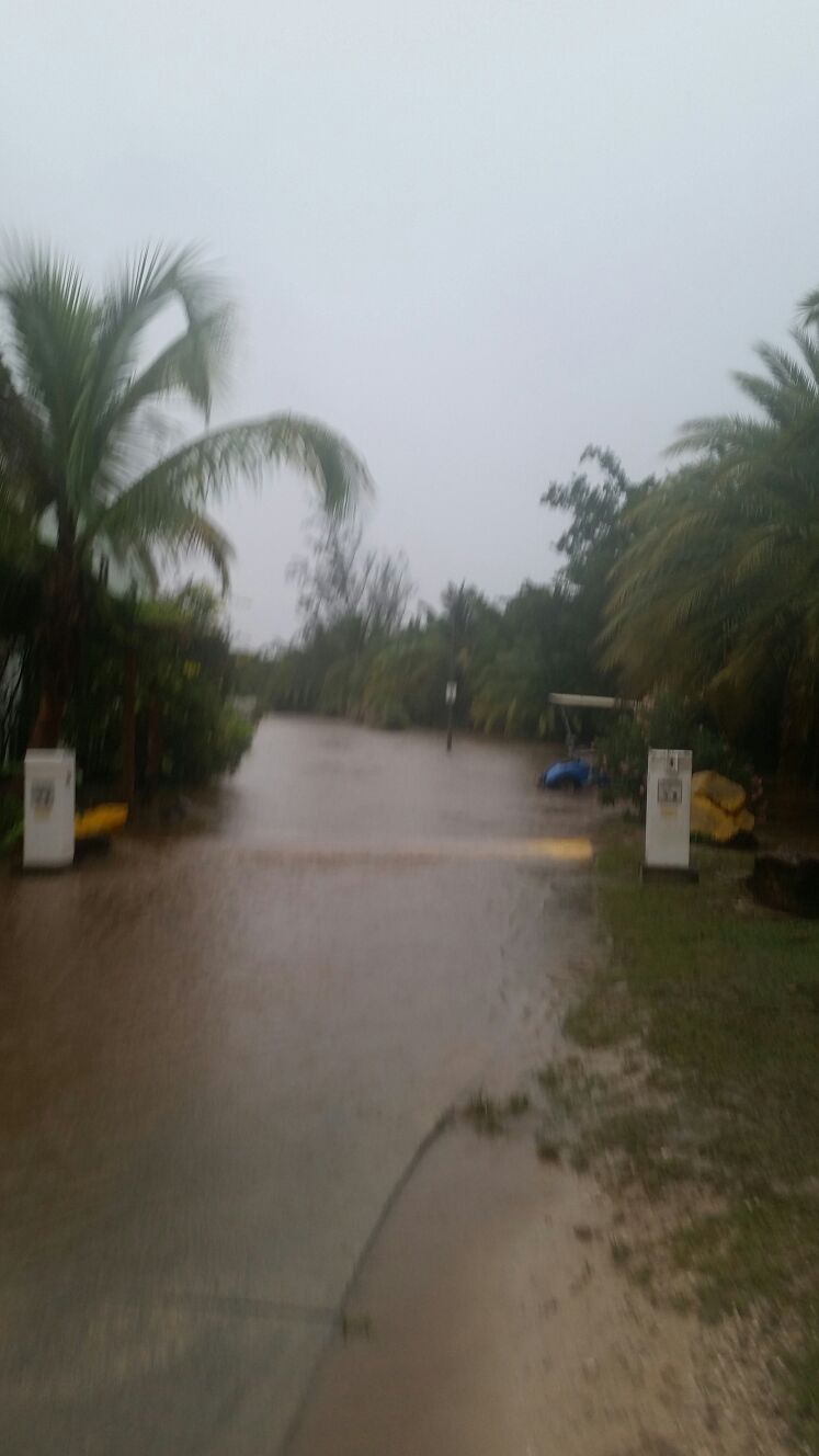
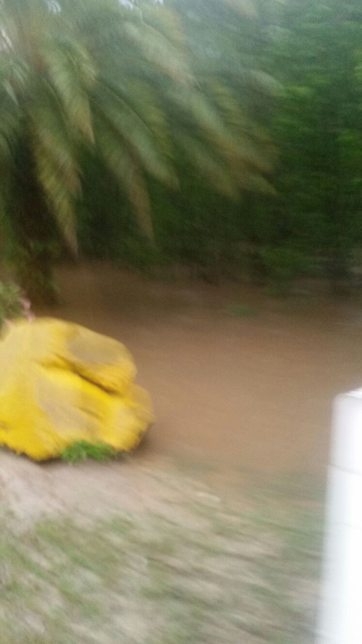
Yesterday Antigua and  little sister island  BARBUDA   had LOTS AND LOTS  OF
RAIN and  flooding!   I  am  in BARBUDA so have not heard  of reports of  any
damage from  flooding   but  we are  always thankful for  rain being  such a
dry island.    WE hope this is the  end for the  2016 HURRICANE SEASON!
|
|
- Flash Flood Watch Statement
|
- By Daniella Seepaul <daniellaseepaul at gmail.com>
- Date: Tue, 1 Nov 2016 19:47:17 -0400
|
Hi All,
Antigua Meteorological Services posted:
FLASH FLOOD WATCH STATEMENTWHCA31 TAPA
BULLETIN
FLASH FLOOD WATCH
ANTIGUA AND BARBUDA METEOROLOGICAL SERVICES
10:00 AM ECT TUE NOV 1 2016 THE LEEWARD ISLANDS AND BRITISH VIRGIN ISLANDS ANTIGUA AND BARBUDA METEOROLOGICAL SERVICES HAS ISSUED A FLASH FLOOD WATCH FOR LOW LYING AND FLOOD PRONE AREAS OF ANTIGUA, BARBUDA, MONTSERRAT, ST. KITTS, NEVIS, ANGUILLA AND THE BRITISH VIRGIN ISLANDS VALID FROM 10 A.M. TODAY UNTIL 10 A.M. TOMORROW WEDNESDAY. A FLASH FLOOD WATCH MEANS THAT CONDITIONS MAY DEVELOP THAT LEAD TO MODERATE TO MAJOR FLOODING IN LOW LYING AND FLOOD PRONE AREAS. PRECAUTIONS SHOULD BE TAKEN TO SAFE GUARD LIFE AND PROPERTY. SOME HOUSES IN LOW LYING AND FLOOD PRONE AREAS MAY REQUIRE EVACUATION. FLASH FLOODING IS A VERY DANGEROUS SITUATION. YOU SHOULD MONITOR LATER FORECASTS AND MOVE QUICKLY TO HIGHER GROUND IF FLASH FLOODING IS OBSERVED OR IMMINENT OR IF A FLASH FLOOD WARNING IS ISSUED. NOTE, JUST ONE FOOT OF FLOWING WATER IS ENOUGH TO SWEEP VEHICLES OFF THE ROAD. WHEN ENCOUNTERING FLOODED ROADS, BE EXTREMELY CAUTIOUS, AND IF IN DOUBT, MAKE THE SMART CHOICE, TURN AROUND DON'T DROWN, MOVE TO HIGHER GROUND. A LOW PRESSURE AREA IN THE VICINITY IS EXPECTED TO CAUSE FURTHER INSTABILITY ACROSS THE REGION. BASED ON RADAR ESTIMATES, UP TO 50 MM (2 IN) RAIN HAS FALLEN ACROSS PARTS OF THE NORTHEAST CARIBBEAN. A FURTHER 25 TO 100 MM (1 TO 4 IN) IS POSSIBLE OVER THE NEXT 24 HOURS. HENCE, MODERATE TO MAJOR FLOODING OF LOW LYING AND FLOOD PRONE AREAS IS POSSIBLE. ANTIGUA AND BARBUDA METEOROLOGICAL SERVICES WILL CONTINUE TO MONITOR THE SITUATION. PLEASE CALL 463-4638 OR STAY TUNED TO LOCAL RADIO AND TV STATIONS FOR LATER STATEMENTS AND POSSIBLE WARNINGS. FORECASTER DALE DESTIN
Regards, Daniella Seepaul |
|
- CLOUD COVER OVER THE ISLANDS
|
- By Martha Watkins Gilkes <marthawatkinsgilkes at gmail.com>
- Date: Wed, 28 Sep 2016 16:53:24 -0400
|
|
|
|
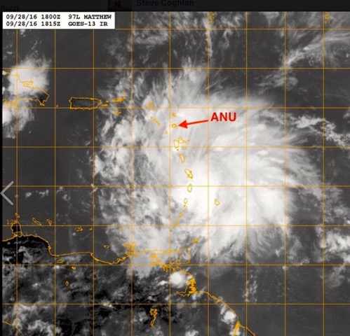
- TS Matthew
|
- By Daniella Seepaul <daniellaseepaul at gmail.com>
- Date: Wed, 28 Sep 2016 14:08:00 -0400
|
Hi All,
Currently Antigua is experiencing some gusty winds (some earlier measuring up to 40 Mph according to Antigua met), squally rain, and choppy sea. Winds are forecast to get a bit stronger this evening. Hope all islands south of Antigua is doing well. Stay safe!
Regards, Daniella Seepaul
|
|
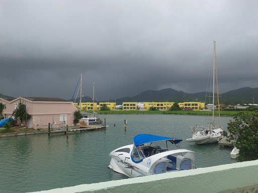
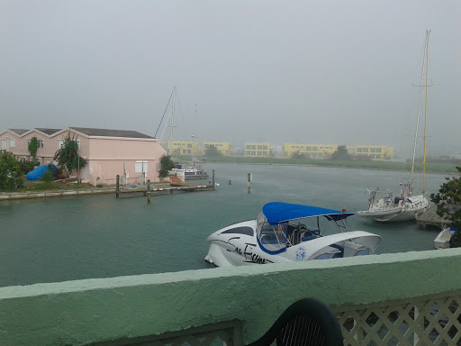
- waking up to this over us 2016-09-28 at 5.21.18 AM
|
- By Martha Watkins Gilkes <marthawatkinsgilkes at gmail.com>
- Date: Wed, 28 Sep 2016 05:33:34 -0400
|
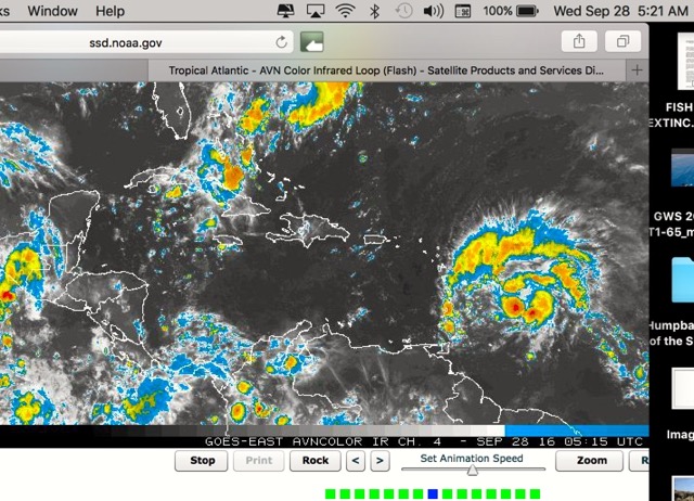 2016-09-28 at 5.21.18 AM
|
|
|
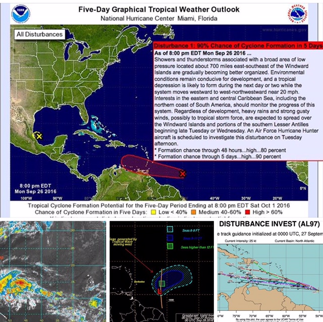
- Hurricane hunters report
|
- By Martha Watkins Gilkes <marthawatkinsgilkes at gmail.com>
- Date: Tue, 27 Sep 2016 17:46:35 -0400
|
Good news so far but system will probably develop more as it moves. 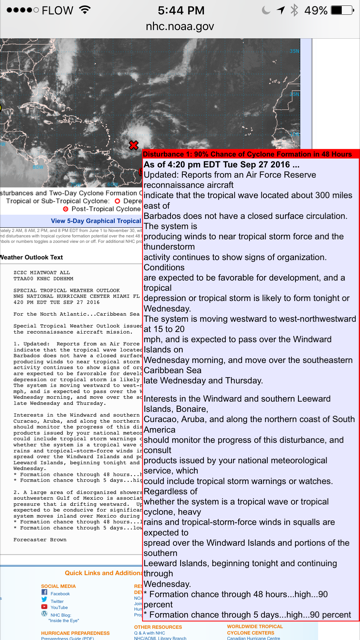 Martha Watkins Gilkes P.O. Box W1924 Antigua, West Indies 268 460 4423 Cell 2687647722 Sent from my fab iPhone
|
|
|
- Disturbance Alert
|
- By Daniella Seepaul <daniellaseepaul at gmail.com>
- Date: Tue, 27 Sep 2016 07:18:55 -0400
|
Hi All,
Antigua Meteorological Services posted:
TROPICAL CYCLONE ALERT STATEMENTWHCA31 TAPA
TROPICAL DISTURBANCE ALERT STATEMENT
ANTIGUA AND BARBUDA METEOROLOGICAL SERVICES
6:30 AM ECT TUE, SEP 27, 2016 THIS IS FOR THE LEEWARD ISLANDS AND BRITISH VIRGIN ISLANDS SHOWERS AND THUNDERSTORMS ASSOCIATED WITH A BROAD AREA OF LOW PRESSURE LOCATED ABOUT 600 MILES EAST-SOUTHEAST OF THE WINDWARD ISLANDS, CONTINUE TO SHOW SIGNS OF ORGANIZATION AND A TROPICAL CYCLONE COULD BE FORMING. IF THIS TREND CONTINUES, THEN A TROPICAL DEPRESSION OR A TROPICAL STORM WOULD LIKELY FORM LATER TODAY WHILE THE SYSTEM MOVES WEST-NORTHWESTWARDS TO WESTWARDS AT ABOUT 20MPH. AS A RESULT, WATCHES AND WARNINGS COULD BE REQUIRED AT ANY TIME. REGARDLESS OF DEVELOPMENT, HEAVY RAINS AND STRONG GUSTY WINDS POSSIBLY TO TROPICAL STORM FORCE, ARE EXPECTED TO SPREAD MAINLY OVER THE WINDWARD ISLANDS AND PORTIONS OF THE SOUTHERN LESSER ANTILLES BEGINNING TONIGHT AND CONTINUING INTO WEDNESDAY. AN AIR FORCE RESERVE RECONNAISSANCE AIRCRAFT IS SCHEDULED TO INVESTIGATE THE DISTURBANCE THIS AFTERNOON. WHEREAS THIS DISTURBANCE HAS A GREATER CHANCE OF AFFECTING THE WINDWARDS ISLANDS, RESIDENTS OF THE LEEWARD ISLANDS SHOULD CLOSELY MONITOR THE PROGRESS OF THIS SYSTEM FORECASTER LENARD JOSIAH
Regards,
Daniella Seepaul |
|
- Latest on the system
|
- By Martha Watkins Gilkes <marthawatkinsgilkes at gmail.com>
- Date: Tue, 27 Sep 2016 05:48:43 -0400
|
|
|
|
- Latest showing this far south
|
- By Martha Watkins Gilkes <marthawatkinsgilkes at gmail.com>
- Date: Sun, 25 Sep 2016 14:44:22 -0400
|
Martha Watkins Gilkes
P.O. Box W1924
Antigua, West Indies
268 460 4423
Cell 2687647722
Sent from my  fab iPhone
Marthawatkinsgilkes at gmail.com
|
|
- Still. Heading towards us. The
|
- By Martha Watkins Gilkes <marthawatkinsgilkes at gmail.com>
- Date: Sun, 25 Sep 2016 05:11:14 -0400
|
By mid week 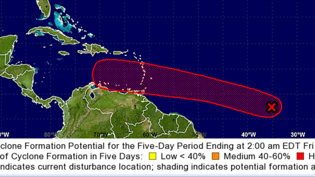 Martha Watkins Gilkes P.O. Box W1924 Antigua, West Indies 268 460 4423 Cell 2687647722 Sent from my fab iPhone
|
|
|
- Don't like this track
|
- By Martha Watkins Gilkes <marthawatkinsgilkes at gmail.com>
- Date: Fri, 23 Sep 2016 18:52:22 -0400
|
Martha Watkins Gilkes
P.O. Box W1924
Antigua, West Indies
268 460 4423
Cell 2687647722
Sent from my  fab iPhone
Marthawatkinsgilkes at gmail.com
|
|
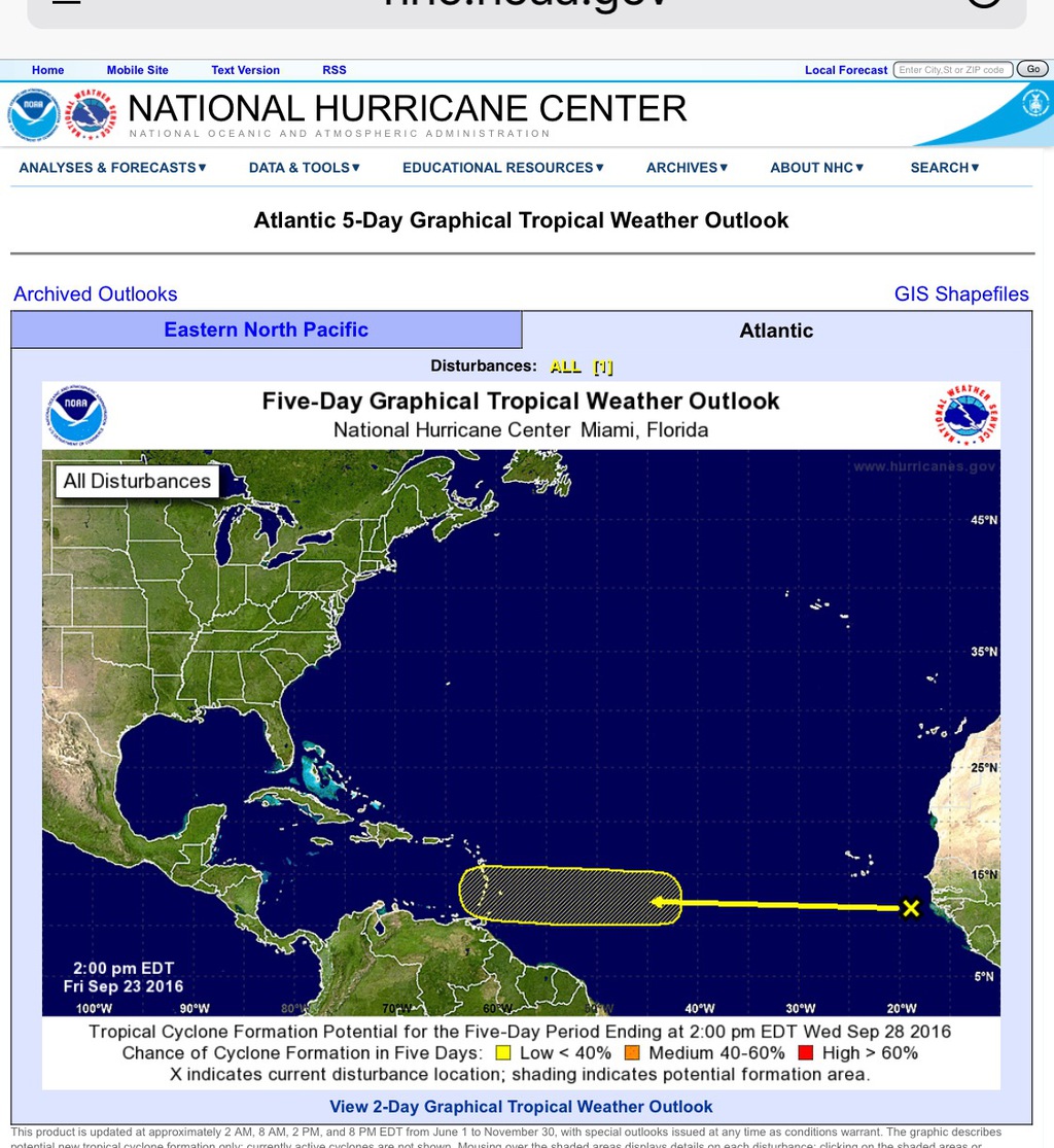
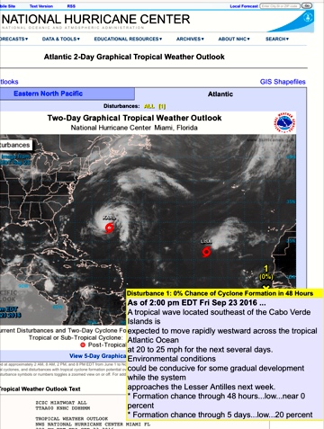
- watching now......
|
- By Martha Watkins Gilkes <marthawatkinsgilkes at gmail.com>
- Date: Fri, 23 Sep 2016 13:40:30 -0400
|
KARL has past us, LISA HAS PASSED us.. AND NOW all eyes are on the yellow X just off the Cabo Verde Islands…. The “hurricane jingle” says SEPTEMBER ALL OVER but we still a week to go ( and besides that is NOT THE TRUTH!) This one is so far south THAT IS NOT A GOOD THINK for the leeward islands.. and as the “backroom boy” says.. eyes to the south as we watch this… hopefully it will bring RAIN and no wind… late next week…. Tis the season in the islands ….
|
|
|
- 2016
|
- By Johnefuller <johnefuller at gmail.com>
- Date: Thu, 22 Sep 2016 19:03:31 -0400
|
Heads up down south!

Sent from my iPhone
|
|
- Watching now
|
- By Martha Watkins Gilkes <marthawatkinsgilkes at gmail.com>
- Date: Mon, 19 Sep 2016 04:59:04 -0400
|
Hope the north turn starts tonight.
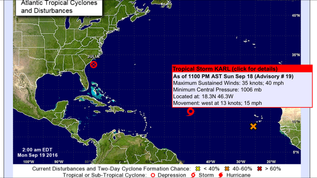
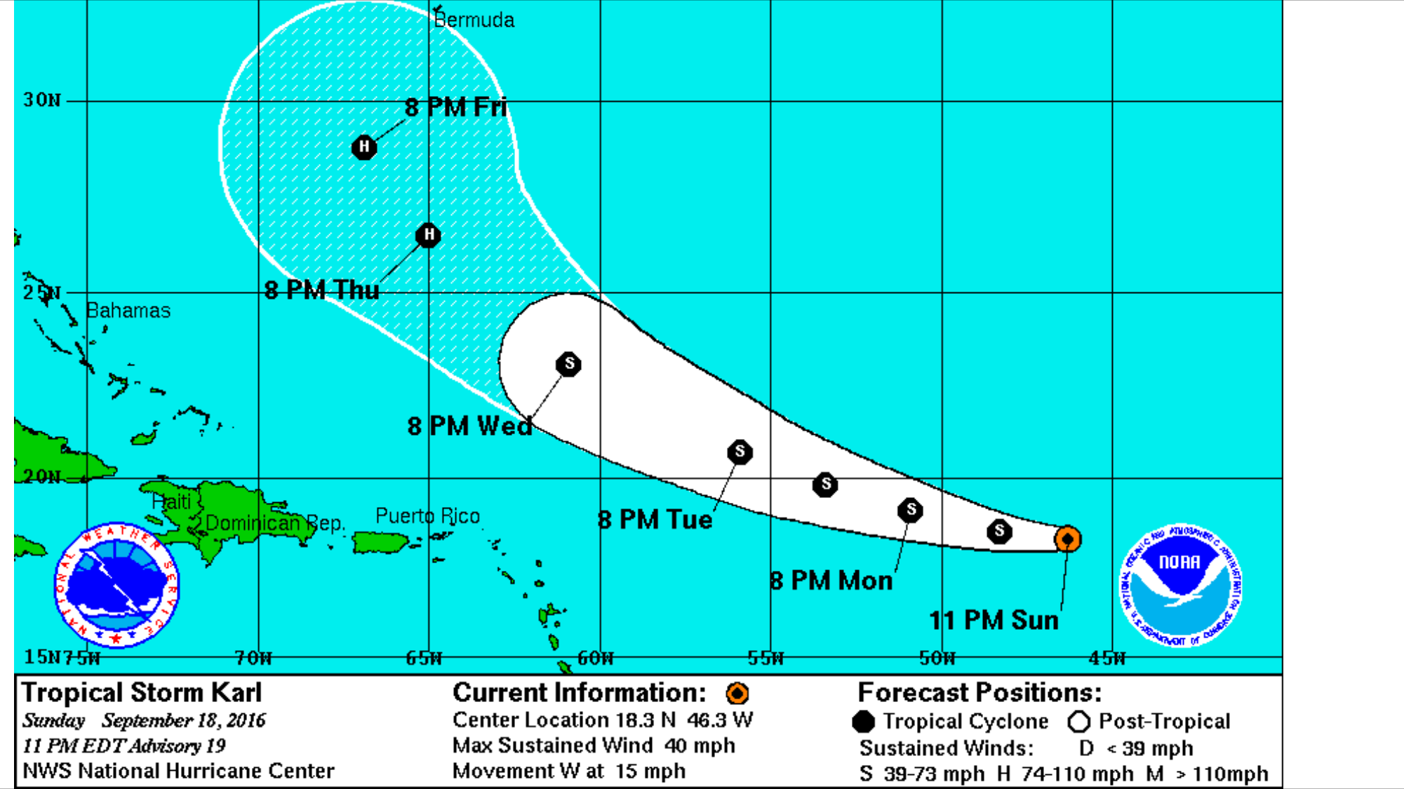
Martha Watkins Gilkes
P.O. Box W1924
Antigua, West Indies
268 460 4423
Cell 2687647722
Sent from my  fab iPhone
Marthawatkinsgilkes at gmail.com
|
|
- System we are watching now
|
- By Martha Watkins Gilkes <marthawatkinsgilkes at gmail.com>
- Date: Sat, 10 Sep 2016 04:29:32 -0400
|
1100 miles off ! Projected track is a north turn. Good news if so.
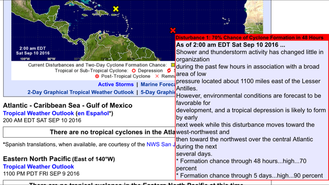
Martha Watkins Gilkes
P.O. Box W1924
Antigua, West Indies
268 460 4423
Cell 2687647722
Sent from my  fab iPhone
Marthawatkinsgilkes at gmail.com
|
|
- Tropical Cyclone Alert
|
- By Daniella Seepaul <daniellaseepaul at gmail.com>
- Date: Fri, 9 Sep 2016 11:40:01 -0400
|
Hi All,
Antigua Meteorological Services posted:
TROPICAL CYCLONE ALERT STATEMENTWHCA31 TAPA
TROPICAL DISTURBANCE ALERT STATEMENT
ANTIGUA AND BARBUDA METEOROLOGICAL SERVICES
10:11 AM ECT FRI, SEP 9, 2016 A LARGE AREA OF DISTURBED WEATHER ASSOCIATED WITH A TROPICAL WAVE CONTINUES TO MOVE WESTWARDS AND IS LOCATED ABOUT 1200 MILES EAST OF THE LESSER ANTILLES. THE SYSTEM IS GETTING BETTER ORGANIZE AND CONDITIONS ARE FORECAST TO BE FAVORABLE FOR THE DEVELOPMENT OF A TROPICAL DEPRESSION BY THIS WEEKEND OR EARLY NEXT WEEK. ALTHOUGH THIS SYSTEM IS FORECAST TO MOVE NORTH WESTWARDS AWAY FROM THE ISLANDS, RESIDENTS IN THE LEEWARDS AND VIRGIN ISLANDS SHOULD CLOSELY MONITOR THE PROGRESS OF THIS SYSTEM OVER THE NEXT FEW DAYS. FORECASTER CECIL MATTHEW
Regards, Daniella Seepaul |
|
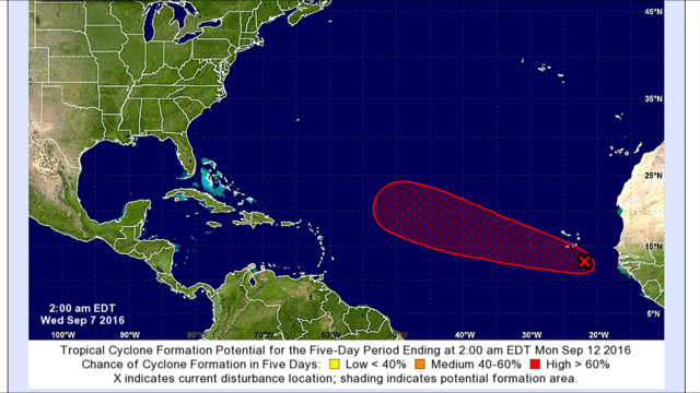
- Latest update
|
- By Martha Watkins Gilkes <marthawatkinsgilkes at gmail.com>
- Date: Wed, 7 Sep 2016 05:07:52 -0400
|
Projection is. Good for us. If. This holds with this north turn !
|
|
- What we are watching now.
|
- By Martha Watkins Gilkes <marthawatkinsgilkes at gmail.com>
- Date: Tue, 6 Sep 2016 06:27:18 -0400
|
Today is big clean up all over the island including my own home from  major
rains yesterday !     And we are watching this next system coming off Africa.
Note red blob.   Island chain to left !     And comments from National
Hurricane. Ctr !
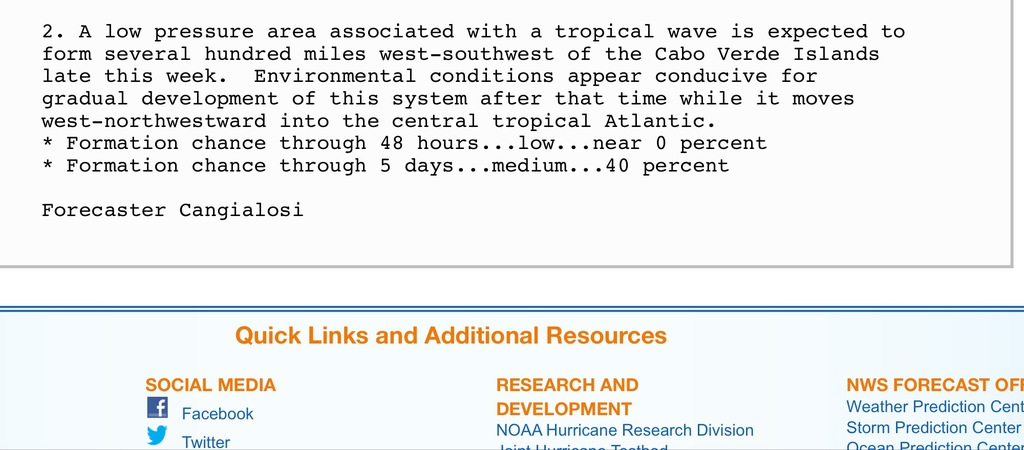
Martha Watkins Gilkes
P.O. Box W1924
Antigua, West Indies
268 460 4423
Cell 2687647722
Sent from my  fab iPhone
Marthawatkinsgilkes at gmail.com
|
|
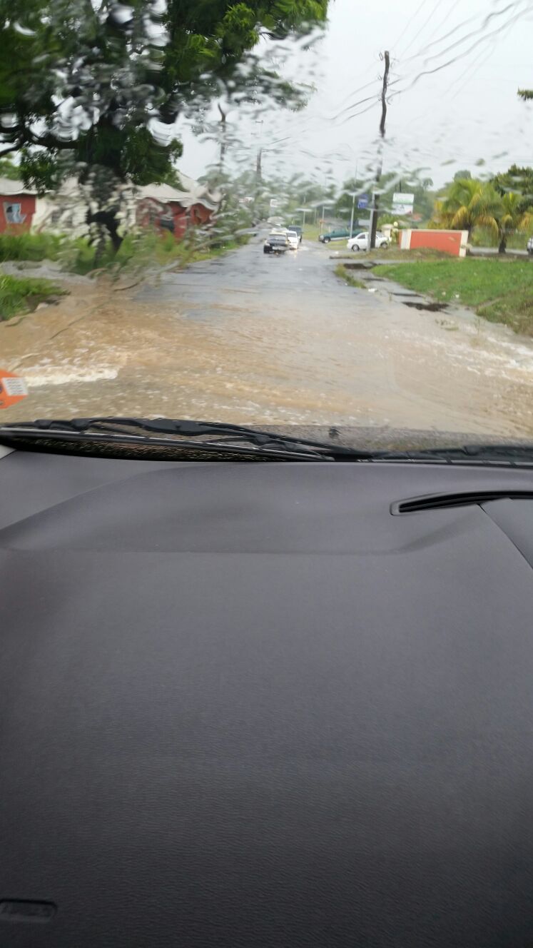
- Flash Flooding in Antigua
|
- By Daniella Seepaul <daniellaseepaul at gmail.com>
- Date: Mon, 5 Sep 2016 18:26:04 -0400
|
Hi All, Antigua have been experiencing alot of rain and alot of flash flooding.
Please be careful.
Regards, Daniella Seepaul |
|
- Flash Flood Warning
|
- By Daniella Seepaul <daniellaseepaul at gmail.com>
- Date: Mon, 5 Sep 2016 11:59:02 -0400
|
Hi All,
Antigua Meteorological Services posted:
FLASH FLOOD WARNING STATEMENTTAPA
BULLETIN
FLASH FLOOD WARNING
ANTIGUA AND BARBUDA METEOROLOGICAL SERVICES
10:12 AM ECT MON, SEP 5, 2016 ANTIGUA AND BARBUDA METEOROLOGICAL SERVICES HAS ISSUED A FLASH FLOOD WARNING FOR LOW LYING AND FLOOD PRONE AREAS OF ANTIGUA, BARBUDA, MONTSERRAT, AND ST. KITTS AND NEVIS UNTIL 2 PM TODAY. A FLASH FLOOD WARNING MEANS THAT MODERATE TO MAJOR FLOODING IS IMMINENT OR OCCURRING IN LOW LYING AND FLOOD PRONE AREAS. AN ACTIVE TROPICAL WAVE IS AFFECTING THE AREA. RESIDENTS LIVING ALONG STREAMS, CREEKS, LOW LYING AND FLOOD PRONE AREAS SHOULD TAKE PRECAUTIONS TO SAFEGUARD AGAING RISING FLOOD WATERS. DO NOT ATTEMPT TO CROSS SWIFTLY FLOWING WATERS OR WATERS OF UNKNOWN DEPTH BY FOOT OR BY VEHICLE. NOTE, JUST ONE FOOT OF FLOWING WATER IS ENOUGH TO SWEEP VEHICLES OFF THE ROAD. WHEN ENCOUNTERING FLOODED ROADS BE EXTREMELY CAUTIOUS, AND IF IN DOUBT, MAKE THE SMART CHOICE, TURN AROUND DONT DROWN. MOVE TO HIGHER GROUND. ALREADY, UP TO ONE AND A HALF INCH OF RAIN HAVE FALLEN IN SOME PLACES IN THE LAST 6 HOURS AND ANOTHER INCH IS LIKELY IN THE NEXT 6 HOURS. ANTIGUA AND BARBUDA METEOROLOGICAL SERVICES WILL CONTINUE TO MONITOR THE SITUATION. PLEASE CALL 463-4638 OR STAY TUNED TO LOCAL RADIO AND TV STATIONS FOR LATER STATEMENTS. FORECASTER ORVIN PAIGE
Regards, Daniella Seepaul
|
|
- Rain rain in Antigua
|
- By Martha Watkins Gilkes <marthawatkinsgilkes at gmail.com>
- Date: Mon, 5 Sep 2016 11:55:54 -0400
|
Heavy rain for hours now. But welcome. No serious wind !!!
Martha Watkins Gilkes P.O. Box W1924 Antigua, West Indies 268 460 4423 Cell 2687647722 Sent from my fab iPhone
|
|
|
- Rain
|
- By Daniella Seepaul <daniellaseepaul at gmail.com>
- Date: Mon, 5 Sep 2016 08:33:48 -0400
|
Hi All, Antigua have been getting a bit of rain and gusty winds this morning. Hope all is well in islands south of Antigua. 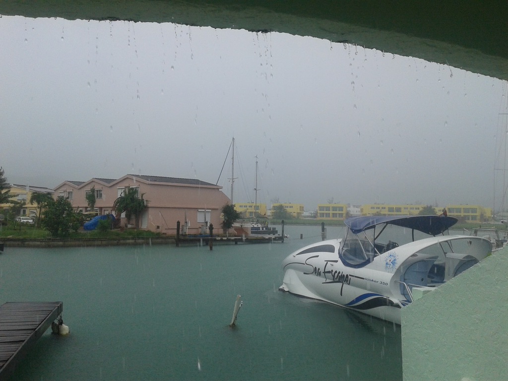
Regards, Daniella Seepaul |
|
- 92L
|
- By Daniella Seepaul <daniellaseepaul at gmail.com>
- Date: Sun, 4 Sep 2016 10:10:11 -0400
|
Hi Fellow Islanders,
Presently Antigua is experiencing periodic gusty winds, nothing terrible though, and overcast skies. We continue to monitor 92L as it makes its way through the Leeward Islands, praying all continues to go well for our fellow islands south of Antigua.
Be vigilant! Be prepared!
Present weather conditions Reeds Point Antigua
Regards, Daniella Seepaul
|
|
- Latest weather system
|
- By Martha Watkins Gilkes <marthawatkinsgilkes at gmail.com>
- Date: Wed, 31 Aug 2016 16:39:20 -0400
|
GOOD NEWS From Dave here on STORM CARIB.. guess we can forget 92 L but gotta watch the African coast!
Back in our neck of the Caribbean woods, that gritty, reddish colored, haze inducing Saharan Dust has choked off what was the stepchild with promise known for a short while as 92L. This is very good news for the Caribbean and points farther west as it originally was forecast to become possibly another major player along the east coast and/or Gulf of Mexico after first ravaging parts of the eastern Caribbean. A shell of it's former self, the artist formerly known as 92L remains a tropical wave with a 1012mb low attached to it and while presumed defunct for the next 5 days, the possibilities of resurrection are probable once past 55W in some form. We are, after all, in prime time.
|
|
|
- 92-L DUBBED
|
- By Martha Watkins Gilkes <marthawatkinsgilkes at gmail.com>
- Date: Wed, 31 Aug 2016 11:18:03 -0400
|
An area of low pressure is now located in the eastern Atlantic and is now designated Invest 92-L, according to Crown Weather on Tuesday morning. “The thunderstorm activity around this system has weakened quite a bit and this is normal when tropical waves first move into the eastern Atlantic from the African continent. “It is forecast that Invest 92-L will quickly move to the west at 20 mph over the next several days and this quick forward motion is likely to lead to very slow development. In addition, a large plume of dry air is located very close to Invest 92-L and this will also slow down any development. At this point, I think that it may be several days until we see this system start to develop. “At this point, the model consensus is for Invest 92-L to not develop until it moves past 50 West Longitude this weekend. This means that this system may be developing and intensifying as it’s passing over the northern Lesser Antilles, Virgin Islands and Puerto Rico on Sunday night and Monday. “Bottom line is that this is a system to keep an eye on, however, any development of it will be very slow to occur. One thing to keep in mind though is that it still looks like that a large ridge of high pressure could guide this system across the entire Atlantic. So, everyone across the eastern and north-eastern Caribbean, the Bahamas and the US East Coast should just keep an eye on Invest 92-L for now,” Crown Weather concludes. ARCHIVE, August 29, 2016 - SINT MAARTEN/CARIBBEAN - A tropical wave is expected to move off of the coast of Africa into the eastern Atlantic tonight (Monday) according to Crown Weather. “Environmental conditions are forecast to be favorable for this tropical wave to slowly develop during the middle and last part of this week. This is a tropical wave that will need to be monitored very closely as the upper level pattern is favorable for this system to not only become a tropical storm and possibly even a hurricane, but also be driven westward underneath a large area of high pressure. “In particular, those of you in the northern Lesser Antilles, Virgin Islands and Puerto Rico should closely monitor this new tropical wave as it is currently forecast to move across these areas aroundnext Monday. “At this point, I want to see how organized this tropical wave is when it moves into the eastern Atlantic and then go from there. If we do see a large ridge of high pressure set up across the Atlantic, then this is a system that may really need to be watched, not only for the eastern Caribbean, but also for the Bahamas and the US East Coast. For now, however, it is something to just watch,” Crown Weather concludes.
|
|
|
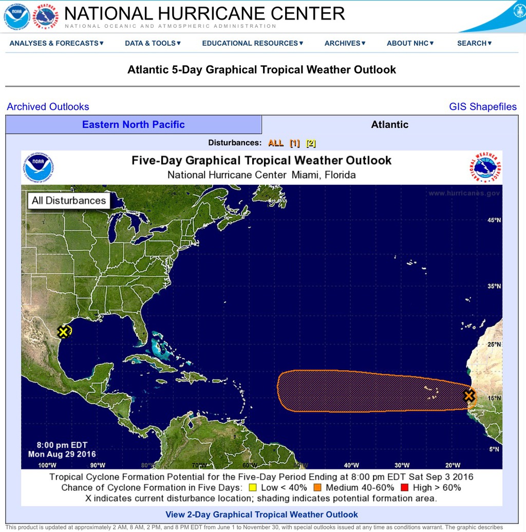
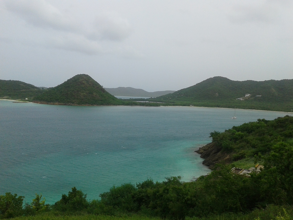
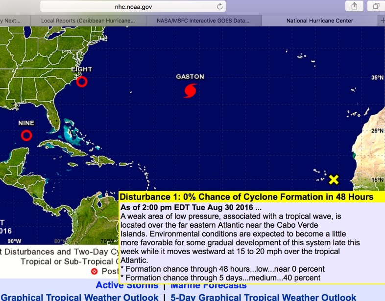
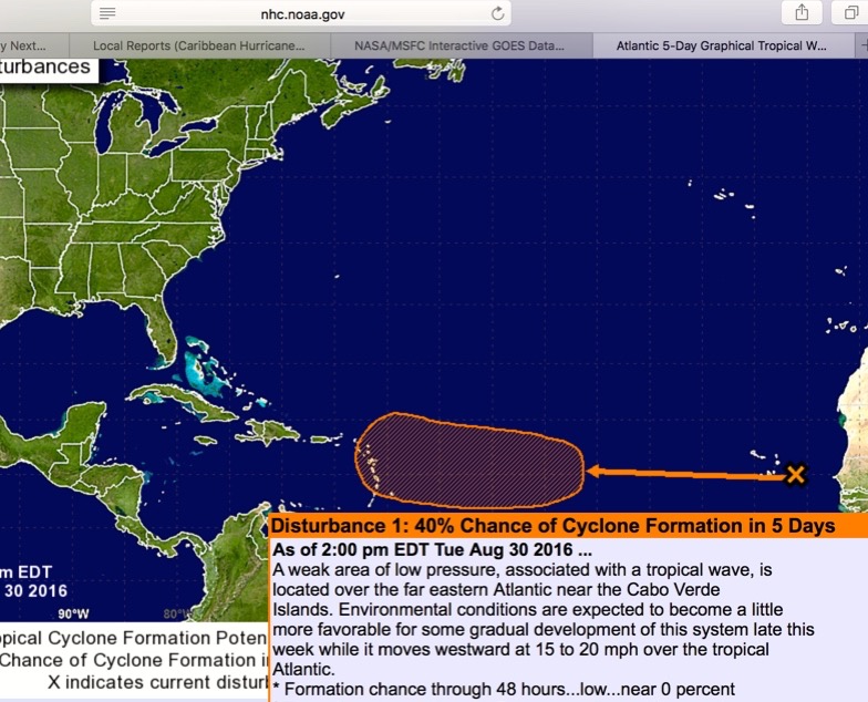
- What we are watching possibly coming our way....
|
- By Martha Watkins Gilkes <marthawatkinsgilkes at gmail.com>
- Date: Tue, 30 Aug 2016 16:51:37 -0400
|
|
|
|
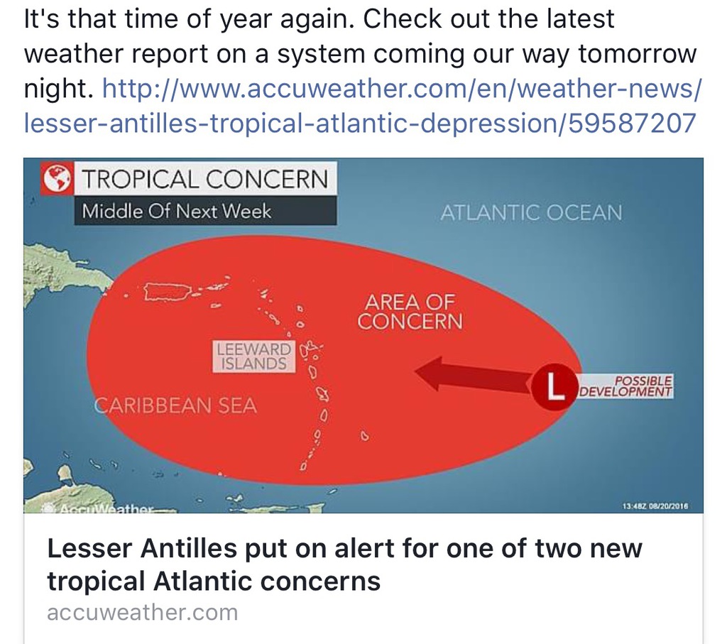
- NEED TO PAY ATTENTION HERE
|
- By Martha Watkins Gilkes <marthawatkinsgilkes at gmail.com>
- Date: Tue, 30 Aug 2016 16:23:02 -0400
|
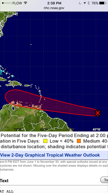
Potential Hurricane Scare Early Next Week30082016Dale C.S. Destin | A weather disturbance coming off West Africa will likely cause a scare to residents of the northeast Caribbean early next week. Two of the more reliable weather models are forecasting this disturbance to become tropical storm or hurricane later this week and track in the direction of the islands. CHECK OUT THIS LINK FOR MORE….
|
|
|
- Watching again
|
- By Martha Watkins Gilkes <marthawatkinsgilkes at gmail.com>
- Date: Mon, 29 Aug 2016 21:01:21 -0400
|
This may be our next irritation. Will be watching.
Martha Watkins Gilkes
P.O. Box W1924
Antigua, West Indies
268 460 4423
Cell 2687647722
Sent from my  fab iPhone
Marthawatkinsgilkes at gmail.com
|
|
- WHY ANTIGUA HAD NO POWER FOR PART OF THE NIGHT.....
|
- By Martha Watkins Gilkes <marthawatkinsgilkes at gmail.com>
- Date: Wed, 24 Aug 2016 14:01:12 -0400
|
THIS WAS RELEASED BY OUR POWER COMPANY! WE HOPE IT CAN BE SOLVED BEFORE A REAL STORM COMES OUR WAY!! On Tuesday 23rd August at approximately 10PM a lightning strike damaged a 69KV line within the Crabbs to Cassada Gardens circuit. At the time of the incident the Crabbs to Lavington 69KV circuit was undergoing maintenance. This maintenance work left the Crabbs to Cassada Gardens circuit as the sole circuit for all electricity transmission, which caused a system wide outage. System restoration began shortly after midnight once the fault had been identified and isolated. Despite only having the capacity to carry 30MW of electricity all feeders were closed by 6AM on Wednesday 24th August. The maintenance work on the Crabbs to Lavington 69KV circuit will be postponed in order to assist in exporting electricity from Crabbs. The restoration of this circuit is estimated to be completed by 4PM. Due to the damage from last night’s lightning strike the Crabbs to Cassada Garden circuit can only maintain 30MW of electricity. Antigua will experience a short period of load shedding until 4PM when the Crabbs to Lavington 69KV circuit is restored. APUA would like to thank all their consumers for their patience and understanding. |
|
|
- STORM MOVING ON THRU OUR NORTHERN NEIGHBORS
|
- By Martha Watkins Gilkes <marthawatkinsgilkes at gmail.com>
- Date: Wed, 24 Aug 2016 13:39:24 -0400
|
AS IS ALWAYS THE CASE… WHAT PASSES THRU US MOVES ON TO OTHERS .. AND USUALLY GETTING STRONGER!! ST MAARTEN JUST RELEASED THIS SO THEY ARE NOW GOING THROUGH WHAT WE HAVE.. WITH stronger winds most likely as this systems moves north…
Beware to our neighbors and hope it does not cause lots of damage along the way...
PUBLIC WEATHER FORECAST FOR ST. MAARTEN DATE ISSUED: Wednesday, August 24, 2016 at 12:00 LST (16:00 UTC) VALID UNTIL: Thursday midday (12:00 LST) August 25, 2016 …A SMALL CRAFT ADVISORY, FLASH FLOOD ADVISORY, and SEVERE WIND ADVISORY ARE IN EFFECT FOR ST. MAARTEN UNTIL FURTHER NOTICE… WEATHER:
This afternoon: Cloudy and windy with scattered showers, some of which may be heavy and possible thunderstorms. Thursday: Partly cloudy to cloudy at times with isolated showers possible. Forecast High: 30°C / 86°F Forecast Low: 24°C / 75°F Sunset Today: 6:32 P.M. Sunrise Tomorrow: 5:57 A.M. SURFACE WINDS:
This afternoon through Thursday midday: Variable with a moderate to near gale force of 15 to 35 miles per hour and higher gusts. SYNOPSIS: An active tropical wave passing through the Lesser Antilles will continue to bring gusty winds and showers, some of which may be heavy with possible thunderstorms, to the local region today. Motorists and residents in areas prone to flooding and falling rocks are advised to be vigilant and exercise caution as flash flooding is still possible. Seas are peaking near 9 feet and are expected to gradually subside on Thursday. Small craft operators and sea bathers should exercise extreme caution and secure their property. STATE OF THE SEA: Rough WAVES/SWELLS: 8 to 9 feet SPECIAL FEATURE: A tropical wave passing through the Lesser Antilles still has a medium (60%) chance of formation in 2 days and a high (80%) chance in 5 days. At 11:00 am today Tropical Storm Gaston had maximum sustained winds near 70 mph. The current forecast track will take Gaston well north of the Lesser Antilles, therefore posing no threat to St. Maarten. The St. Maarten Meteorological Department will continue to monitor the progress of these systems. |
|
|
- STORM MOVING ON THRU OUR NORTHERN NEIGHBORS
|
- By Martha Watkins Gilkes <marthawatkinsgilkes at gmail.com>
- Date: Wed, 24 Aug 2016 13:39:01 -0400
|
AS IS ALWAYS THE CASE… WHAT PASSES THRU US MOVES ON TO OTHERS .. AND USUALLY GETTING STRONGER!! ST MAARTEN JUST RELEASED THIS SO THEY ARE NOW GOING THROUGH WHAT WE HAVE.. WITH stronger winds most likely as this systems moves north…
Beware to our neighbors and hope it does not cause lots of damage along the way...
PUBLIC WEATHER FORECAST FOR ST. MAARTEN DATE ISSUED: Wednesday, August 24, 2016 at 12:00 LST (16:00 UTC) VALID UNTIL: Thursday midday (12:00 LST) August 25, 2016 …A SMALL CRAFT ADVISORY, FLASH FLOOD ADVISORY, and SEVERE WIND ADVISORY ARE IN EFFECT FOR ST. MAARTEN UNTIL FURTHER NOTICE… WEATHER:
This afternoon: Cloudy and windy with scattered showers, some of which may be heavy and possible thunderstorms. Thursday: Partly cloudy to cloudy at times with isolated showers possible. Forecast High: 30°C / 86°F Forecast Low: 24°C / 75°F Sunset Today: 6:32 P.M. Sunrise Tomorrow: 5:57 A.M. SURFACE WINDS:
This afternoon through Thursday midday: Variable with a moderate to near gale force of 15 to 35 miles per hour and higher gusts. SYNOPSIS: An active tropical wave passing through the Lesser Antilles will continue to bring gusty winds and showers, some of which may be heavy with possible thunderstorms, to the local region today. Motorists and residents in areas prone to flooding and falling rocks are advised to be vigilant and exercise caution as flash flooding is still possible. Seas are peaking near 9 feet and are expected to gradually subside on Thursday. Small craft operators and sea bathers should exercise extreme caution and secure their property. STATE OF THE SEA: Rough WAVES/SWELLS: 8 to 9 feet SPECIAL FEATURE: A tropical wave passing through the Lesser Antilles still has a medium (60%) chance of formation in 2 days and a high (80%) chance in 5 days. At 11:00 am today Tropical Storm Gaston had maximum sustained winds near 70 mph. The current forecast track will take Gaston well north of the Lesser Antilles, therefore posing no threat to St. Maarten. The St. Maarten Meteorological Department will continue to monitor the progress of these systems.
|
|
|
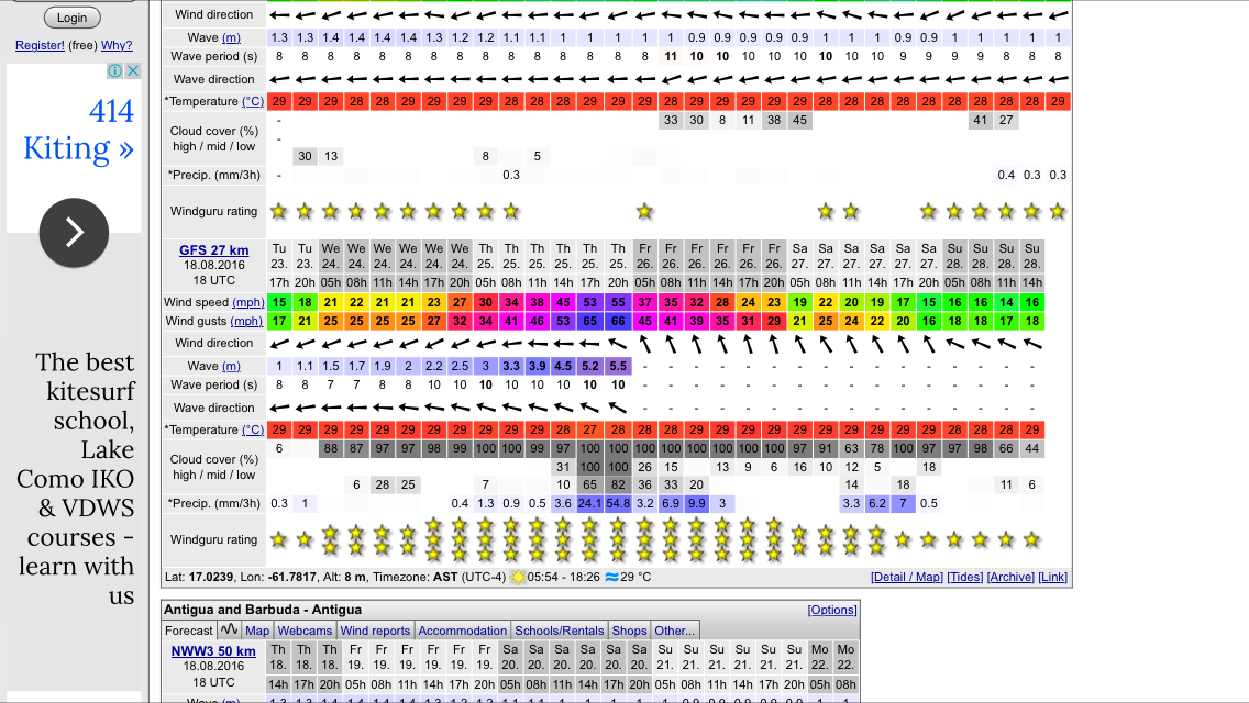
- MORE RAIN TO COME
|
- By Martha Watkins Gilkes <marthawatkinsgilkes at gmail.com>
- Date: Wed, 24 Aug 2016 10:22:48 -0400
|
|
|
|
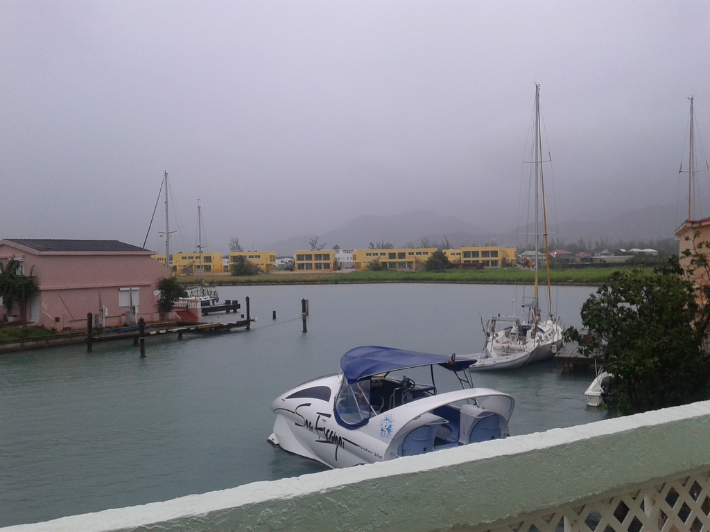
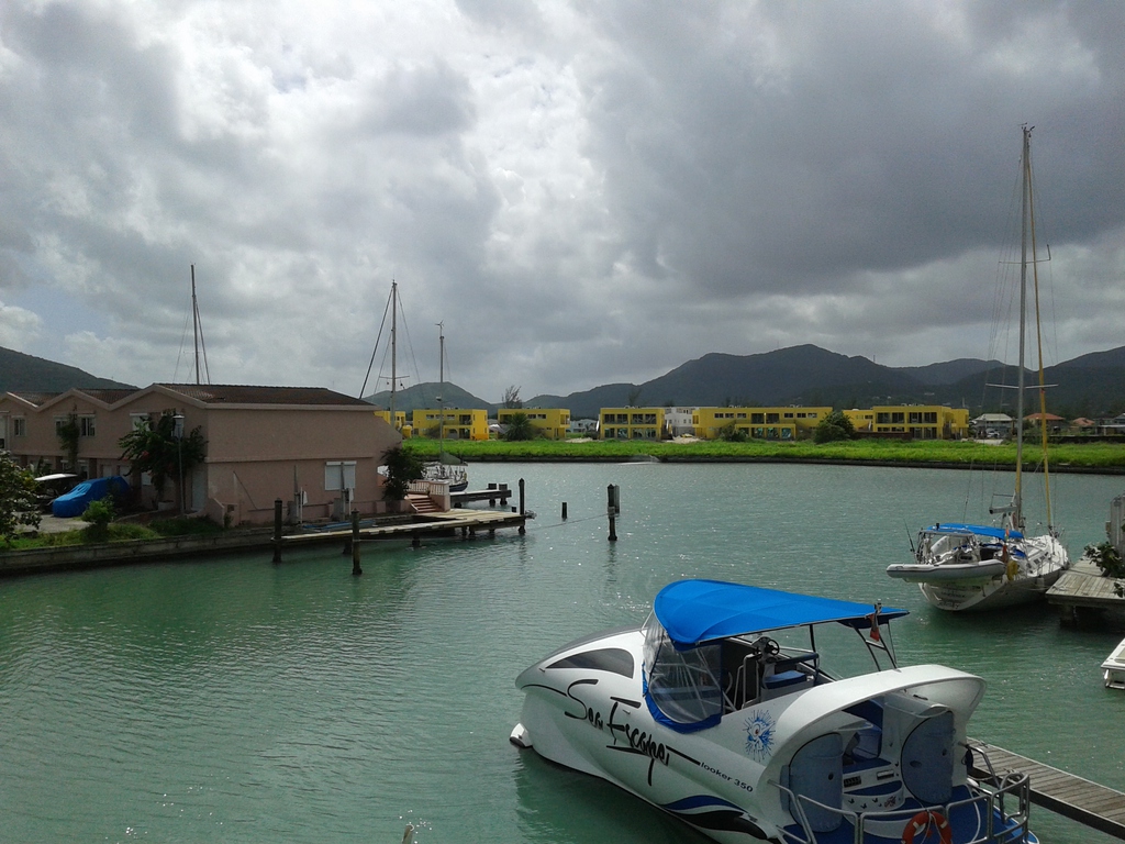
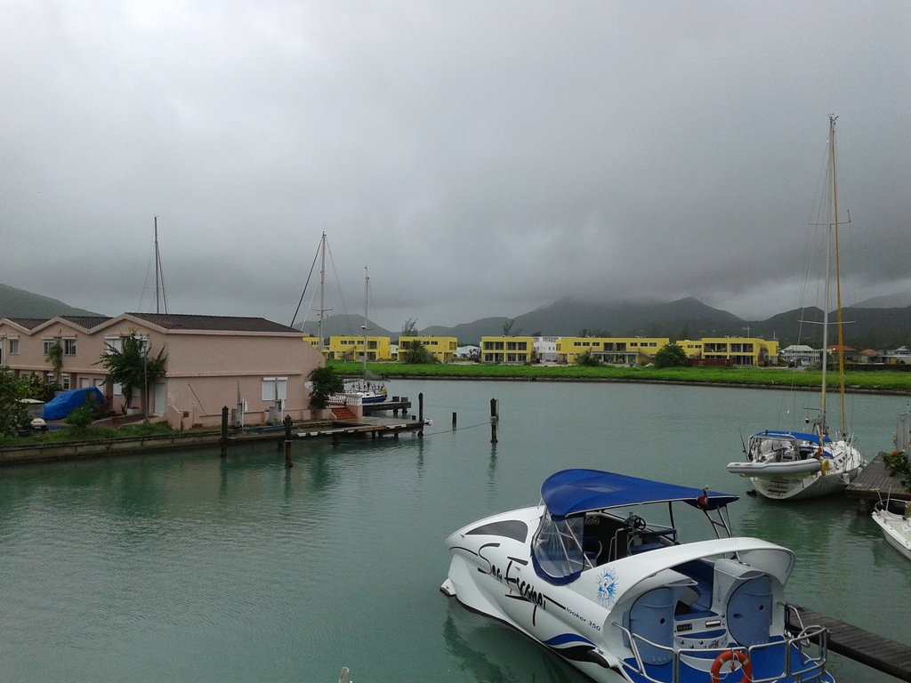
- Current Situation
|
- By Daniella Seepaul <daniellaseepaul at gmail.com>
- Date: Wed, 24 Aug 2016 07:42:18 -0400
|
|
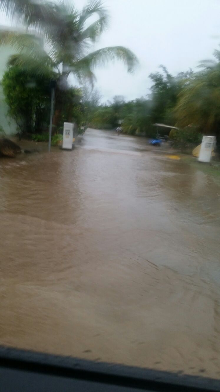
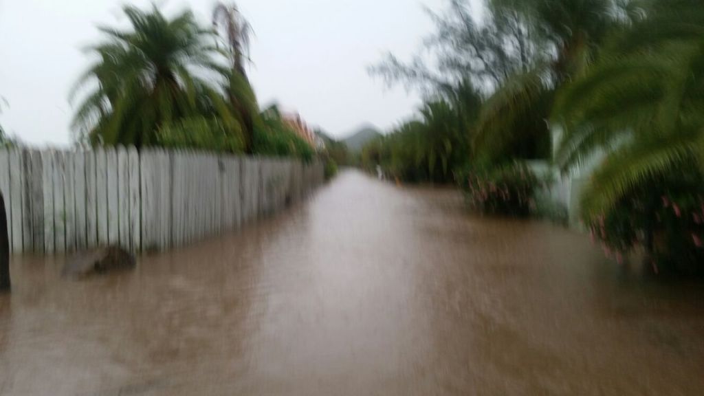
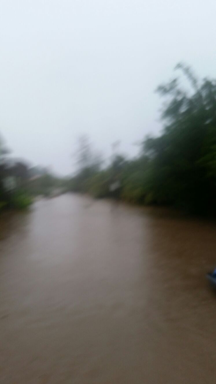
Hi All,
The rain from 99L started around 10:30 pm. The wind can be heard in the marina, but its a gentle howling wind. Our current situation can be seen in the attached photo.
Regards,
Daniella Seepaul
Attachment:
20160824_070608.jpg
Description: JPEG image
|
|
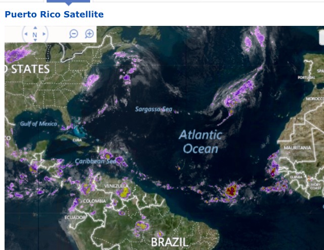
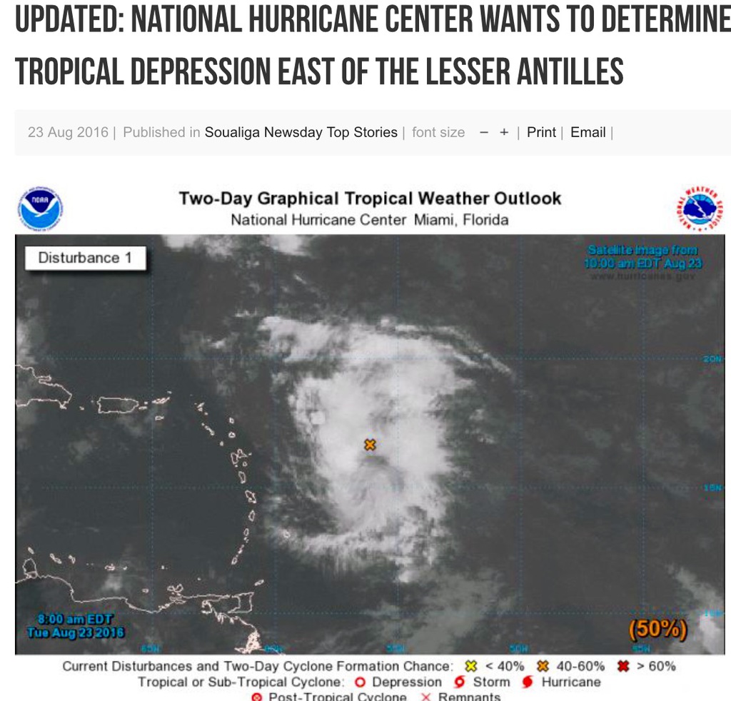
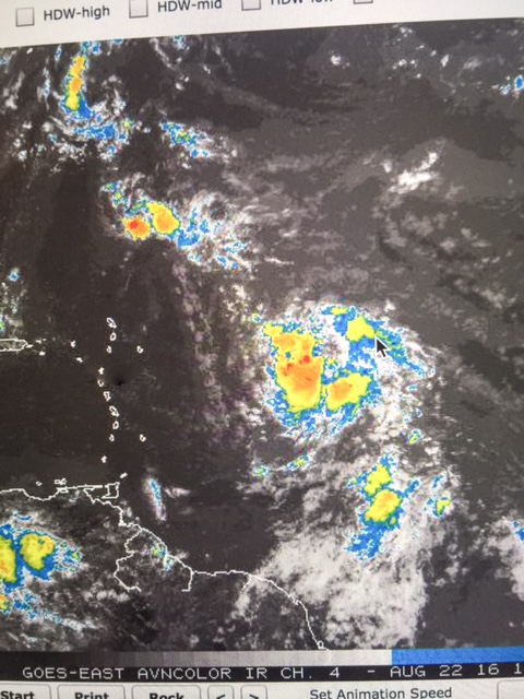
- REAL TIME SAT IMAGE OF THE STORM APPROACHING
|
- By Martha Watkins Gilkes <marthawatkinsgilkes at gmail.com>
- Date: Tue, 23 Aug 2016 17:08:51 -0400
|
|
|
|
- 2 p.m. STORM INFO...
|
- By Martha Watkins Gilkes <marthawatkinsgilkes at gmail.com>
- Date: Tue, 23 Aug 2016 15:05:34 -0400
|
2 p.m. National Hurr Center report in and includes info from HURRICANE HUNTERS
Reports from an Air Force Reserve Hurricane Hunter aircraft indicate that the tropical wave located a few hundred miles east of the Lesser Antilles ( THATS My HOME SWEEt home Antigua! ) has an elongated and poorly defined circulation, according to the 2.00PM weather outlook from the National Hurricane Center (NHC). Interests from the islands of the north-eastern Caribbean Sea to the Bahamas should continue to monitor the progress of this system. “Even if this system is not yet a tropical depression, it will bring some very squally weather to the northern Lesser Antilles starting this afternoon and continuing through tonight and then to the Virgin Islands and Puerto Rico on Wednesday afternoon and Wednesday night. This squally weather will include locally heavy rainfall and gusty winds with gusts of 40 to 50 mph possible in some areas.
http://www.soualiganewsday.com/local/soualiga-newsday-top-stories/item/9480-updated-tropical-wave-east-of-lesser-antilles-could-bring-gusty-winds,-heavy-rains-and-possible-flash-floods-and-mud-slides.html |
|
|
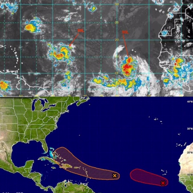
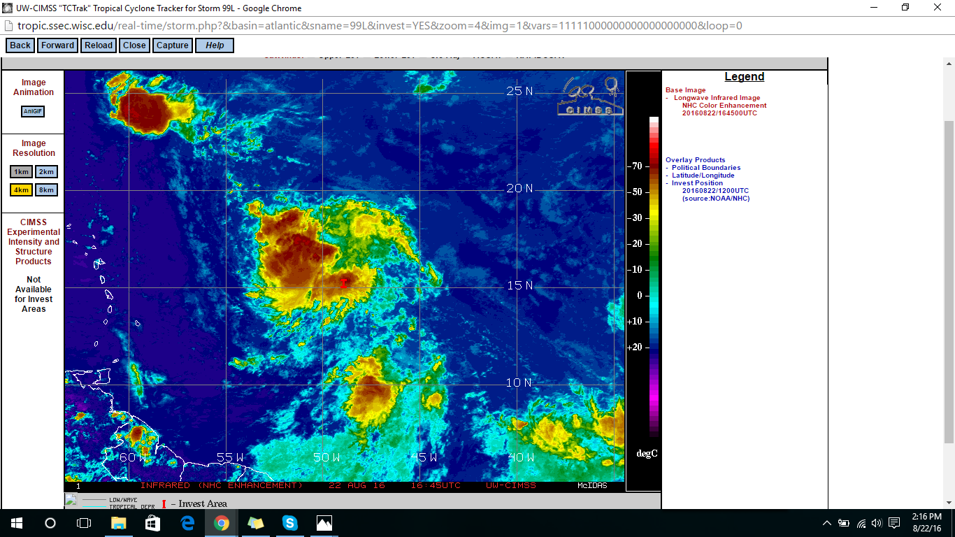
- HURRICANE HUNTERS FLYING THE SUSPECT AREA NOW
|
- By Martha Watkins Gilkes <marthawatkinsgilkes at gmail.com>
- Date: Tue, 23 Aug 2016 13:17:10 -0400
|
This is good news as this will give us a better picture of what is going on in this system.
WEATHER RECONNAISSANCE FLIGHTS
CARCAH, NATIONAL HURRICANE CENTER, MIAMI, FL.
1015 AM EDT MON 22 AUGUST 2016
SUBJECT: TROPICAL CYCLONE PLAN OF THE DAY (TCPOD)
         VALID 23/1100Z TO 24/1100Z AUGUST 2016
         TCPOD NUMBER.....16-088

I.  ATLANTIC REQUIREMENTS
    1. SUSPECT AREA (NEAR LESSER ANTILLES)
       FLIGHT ONE - TEAL 70           FLIGHT TWO - TEAL 71
       A. 23/1500Z                    A. 23/2330Z,24/0530Z
       B. AFXXX 01EEA INVEST          B. AFXXX 0208A CYCLONE
       C. 23/1300Z                    C. 23/2200Z
       D. 16.0N 56.5W                 D. 16.5N 59.0W
       E. 23/1445Z TO 23/1800Z        E. 23/2300Z TO 24/0530Z
       F. SFC TO 10,000 FT            F. SFC TO 10,000 FT

       FLIGHT THREE - TEAL 72
       A. 24/1130Z,1730Z
       B. AFXXX 0308A CYCLONE
       C. 24/1030Z
       D. 17.5N 62.0W
       E. 24/1100Z TO 24/1730Z
       F. SFC TO 10,000 FT
|
|
|
- FOR ANTIGUA FLASH FLOOD WATCH STATEMENT
|
- By Martha Watkins Gilkes <marthawatkinsgilkes at gmail.com>
- Date: Tue, 23 Aug 2016 13:16:31 -0400
|
FLASH FLOOD WATCH STATEMENTWHCA31 TAPA
BULLETIN
FLASH FLOOD WATCH
ANTIGUA AND BARBUDA METEOROLOGICAL SERVICES
11:44 AM ECT TUE AUG 23 2016 THE LEEWARD ISLANDS AND BRITISH VIRGIN ISLANDS ANTIGUA AND BARBUDA METEOROLOGICAL SERVICES HAS ISSUED A FLASH FLOOD WATCH FOR LOW LYING AND FLOOD PRONE AREAS OF ANTIGUA, BARBUDA, MONTSERRAT, ST. KITTS, NEVIS AND ANGUILLA VALID FROM 8 P.M. TONIGHT UNTIL 8 A.M. TOMORROW WEDNESDAY. A FLASH FLOOD WATCH IS ALSO IN EFFECT FOR THE BRITISH VIRGIN ISLANDS VALID 8 A.M. TO 8 P.M. WEDNESDAY. A FLASH FLOOD WATCH MEANS THAT CONDITIONS MAY DEVELOP THAT LEAD TO MODERATE TO MAJOR FLOODING IN LOW LYING AND FLOOD PRONE AREAS. PRECAUTIONS SHOULD BE TAKEN TO SAFE GUARD LIFE AND PROPERTY. SOME HOUSES IN LOW LYING AND FLOOD PRONE AREAS MAY REQUIRE EVACUATION. FLASH FLOODING IS A VERY DANGEROUS SITUATION. YOU SHOULD MONITOR LATER FORECASTS AND MOVE QUICKLY TO HIGHER GROUND IF FLASH FLOODING IS OBSERVED OR IMMINENT OR IF A FLASH FLOOD WARNING IS ISSUED. NOTE, JUST ONE FOOT OF FLOWING WATER IS ENOUGH TO SWEEP VEHICLES OFF THE ROAD. WHEN ENCOUNTERING FLOODED ROADS, BE EXTREMELY CAUTIOUS, AND IF IN DOUBT, MAKE THE SMART CHOICE, TURN AROUND DON'T DROWN, MOVE TO HIGHER GROUND. THE MET OFFICE IS PAYING VERY CLOSE ATTENTION TO AN APPROACHING TROPICAL DISTURBANCE. AS OF 8 A.M. THIS MORNING, IT HAD A 50 CHANCE OF BECOMING A TROPICAL CYCLONE (TROPICAL DEPRESSION, TROPICAL STORM OR HURRICANE) IN 48 HOURS AND A 60 CHANCE IN FIVE DAYS. THE DEVELOPING DISTURBANCE IS EXPECTED TO CAUSE VERY WET WEATHER ACROSS ANTIGUA AND BARBUDA AND THE REST OF THE LEEWARD ISLANDS TUESDAY NIGHT THROUGH WEDNESDAY, AND THE ACROSS THE BRITISH VIRGIN ISLANDS WEDNESDAY THROUGH THURSDAY. RAINFALL TOTALS OF 25 TO 75 MM OR 1 TO 3 INCHES ARE POSSIBLE. THE WEATHER IS EXPECTED TO SUBSIDE BY WEDNESDAY NIGHT ACROSS THE LEEWARD ISLANDS AND BY THURSDAY AFTERNOON ACROSS THE BRITISH VIRGIN ISLANDS. ANTIGUA AND BARBUDA METEOROLOGICAL SERVICESWILL CONTINUE TO MONITOR THE SITUATION. PLEASE CALL 463-4638 OR STAY TUNED TO LOCAL RADIO AND TV STATIONS FOR LATER STATEMENTS AND POSSIBLE WARNINGS. FORECASTER DALE DESTIN |
|
|
- Watching weather coming.
|
- By Martha Watkins Gilkes <marthawatkinsgilkes at gmail.com>
- Date: Tue, 23 Aug 2016 12:36:25 -0400
|
Martha Watkins Gilkes
P.O. Box W1924
Antigua, West Indies
268 460 4423
Cell 2687647722
Sent from my  fab iPhone
Marthawatkinsgilkes at gmail.com
|
|
- Alert
|
- By Daniella Seepaul <daniellaseepaul at gmail.com>
- Date: Tue, 23 Aug 2016 11:26:58 -0400
|
Hi All, Antigua Meteorological Services posted:
TROPICAL CYCLONE ALERT STATEMENTWHCA31 TAPA
TROPICAL DISTURBANCE ALERT STATEMENT
ANTIGUA AND BARBUDA METEOROLOGICAL SERVICES
9:30 AM ECT TUE AUG 23 2016 THIS IS FOR THE LEEWARD ISLANDS AND BRITISH VIRGIN ISLANDS ...TROPICAL DISTURBANCE APPROACHING THE ISLANDS... THE ANTIGUA AND BARBUDA METEOROLOGICAL SERVICE IS PAYING VERY CLOSE ATTENTION TO AN APPROACHING TROPICAL DISTURBANCE. AS OF 8 AM THIS MORNING, IT HAD A 50 CHANCE OF BECOMING A TROPICAL CYCLONE (TROPICAL DEPRESSION, TROPICAL STORM OR HURRICANE) IN 48 HOURS AND A 60 CHANCE IN FIVE DAYS. THESE PROBABILITIES HAVE BEEN STEADILY RISING OVER THE PAST 24 HOURS AND HAVE NOW BECOME A CAUSE FOR SOME CONCERN. ALTHOUGH IT IS STILL MORE LIKELY THAN NOT THAT THE SYSTEM WILL IMPACT US AS NO MORE THAN TROPICAL DISTURBANCE OR STRONG TROPICAL WAVE, WE CANNOT RULE OUT THE DISTURBANCE RAPIDLY DEVELOPING AND IMPACTING US A TROPICAL CYCLONE. HENCE, RESIDENTS ARE URGED TO PAY CLOSE ATTENTION TO THE PROGRESS OF THIS WEATHER SYSTEM UNTIL IT IS OUT OF OUR AREA. THE DEVELOPING DISTURBANCE IS EXPECTED TO CAUSE VERY WET WEATHER ACROSS ANTIGUA AND BARBUDA AND THE REST OF THE LEEWARD ISLANDS TUESDAY NIGHT THROUGH WEDNESDAY, AND THE ACROSS THE BRITISH VIRGIN ISLANDS WEDNESDAY THROUGH THURSDAY. RAINFALL TOTALS OF 25 TO 75 MM OR 1 TO 3 INCHES ARE POSSIBLE. HENCE, A FLASH FLOOD WATCH AND/OR WARNING WILL LIKELY BE REQUIRED FOR PORTIONS OF THE NEXT 24 TO 36 HOURS. HEAVY THUNDERSTORMS ARE ALSO EXPECTED, WHICH COULD INTERRUPT ELECTRICITY AND RELATED SERVICES. LIGHTNING IS VERY DANGEROUS &8211; IT CAN KILL AND INJURE. REMEMBER, WHEN THUNDER ROARS, GO INDOORS! SEAS WILL BECOME HAZARDOUS WITH PEAK HEIGHTS ON WEDNESDAY OF AROUND 2.7 METRES OF 9 FEET. HENCE, SMALL CRAFT AND SEA-BATHER WARNINGS WILL GO INTO EFFECT BY THIS AFTERNOON. THE WEATHER IS EXPECTED TO SUBSIDE BY WEDNESDAY NIGHT ACROSS THE LEEWARD ISLANDS AND BY THURSDAY AFTERNOON ACROSS THE BRITISH VIRGIN ISLANDS. AT THIS TIME, NO STORM-FORCE WINDS ARE ANTICIPATED. PLEASE CONTINUE TO FOLLOW THE PRODUCTS ISSUED BY THE METEOROLOGICAL SERVICE. CLICK HERE FOR MORE INFORMATION FORECASTER DALE DESTIN
Regards, Daniella Seepaul |
|
- Eyes on 99L
|
- By Daniella Seepaul <daniellaseepaul at gmail.com>
- Date: Tue, 23 Aug 2016 10:32:22 -0400
|
Hi All,
Invest 99L is in close proximity to Antigua but no sight of it yet.
Regards, Daniella Seepaul
|
|
- 400 miles away
|
- By Martha Watkins Gilkes <marthawatkinsgilkes at gmail.com>
- Date: Tue, 23 Aug 2016 06:51:48 -0400
|
As of 2 am.  But not so strong yet however we need to be alert.  TS Gaston now
formed. But the track is north Tx goodness !!!
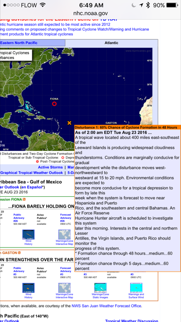
Martha Watkins Gilkes
P.O. Box W1924
Antigua, West Indies
268 460 4423
Cell 2687647722
Sent from my  fab iPhone
Marthawatkinsgilkes at gmail.com
|
|
- Update
|
- By Martha Watkins Gilkes <marthawatkinsgilkes at gmail.com>
- Date: Mon, 22 Aug 2016 14:47:24 -0400
|
|
|
- 99L
|
- By Daniella Seepaul <daniellaseepaul at gmail.com>
- Date: Mon, 22 Aug 2016 14:37:59 -0400
|
Hi All,
99L should be affecting the Leeward islands by tomorrow evening/night until Thursday. And due to Saharan dust, luckily there isn't a major storm at our doorstep. We however, should be prepared for some gusty winds and rain.
Be vigilant!
|
|
- HURRICANE HUNTERS TO FLY SUSPECT AREA STARTING TODAY
|
- By Martha Watkins Gilkes <marthawatkinsgilkes at gmail.com>
- Date: Mon, 22 Aug 2016 13:57:40 -0400
|
FROM TODAY THERE ARE 3 FLIGHTS SCHEDULED FOR THE HURRICANE HUNTERS TO CHECK OUT THE “SUSPECT AREA” 99L So later in the day we will have more accurate info on what this system really is doing… Very unlikely to be more than squalls for the LESSER ANTILLES ( Antigua Included) but this could develop and be problems for the islands along the way and the USA COAST
WEATHER RECONNAISSANCE FLIGHTS
CARCAH, NATIONAL HURRICANE CENTER, MIAMI, FL.
1015 AM EDT MON 22 AUGUST 2016
SUBJECT: TROPICAL CYCLONE PLAN OF THE DAY (TCPOD)
         VALID 23/1100Z TO 24/1100Z AUGUST 2016
         TCPOD NUMBER.....16-088

I.  ATLANTIC REQUIREMENTS
    1. SUSPECT AREA (NEAR LESSER ANTILLES)
       FLIGHT ONE - TEAL 70           FLIGHT TWO - TEAL 71
       A. 23/1500Z                    A. 23/2330Z,24/0530Z
       B. AFXXX 01EEA INVEST          B. AFXXX 0208A CYCLONE
       C. 23/1300Z                    C. 23/2200Z
       D. 16.0N 56.5W                 D. 16.5N 59.0W
       E. 23/1445Z TO 23/1800Z        E. 23/2300Z TO 24/0530Z
       F. SFC TO 10,000 FT            F. SFC TO 10,000 FT

       FLIGHT THREE - TEAL 72
       A. 24/1130Z,1730Z
       B. AFXXX 0308A CYCLONE
       C. 24/1030Z
       D. 17.5N 62.0W
       E. 24/1100Z TO 24/1730Z
       F. SFC TO 10,000 FT
WHAT IS AN INVEST - FOR THOSE WHO NEED HURRICANE 101 ….
https://weather.com/storms/hurricane/news/what-is-an-invest-20120815 |
|
|
- What we are watching
|
- By Martha Watkins Gilkes <marthawatkinsgilkes at gmail.com>
- Date: Mon, 22 Aug 2016 13:41:12 -0400
|
99L. 900 miles away and 90 L. Behind and hope it turns North.
|
|
- WATCHING FOR SOME Squally Weather on our doorstep
|
- By Martha Gilkes <gilkesm at me.com>
- Date: Mon, 22 Aug 2016 13:02:03 -0400
|
WE ARE HOPING FOR SOME RAIN… probably starting tomorrow evening and night…
Closer to home, Saharan Dust snorting 99L is slowly organizing as the concentration of dust is waning and more favorable conditions of less shear, less dust and warmer SST's are in it's current path. It is expected to impact the Lesser Antilles starting late Tuesday night through Thursday with good rain fall amounts and squally winds. 99L's organization has improved significantly from yesterday and by looking at the satellite imagery, needs to fill in it's northern side to finally reach TD status. if it does soon, then the bulk will probably move on a more WNW path. Hard to tell at the moment with this one where it will go after leaving us but the Bahamas and Florida might want to follow it's progression.
also
“Even though Invest 99-L is not expected to be a tropical cyclone when it reaches the Lesser Antilles on Tuesday night, it is still expected to bring some very squally weather to the central and northern Lesser Antilles starting sometime Tuesday afternoon and continuing through Tuesday night and then the Virgin Islands and Puerto Rico on Wednesday afternoon and Wednesday night. This squally weather will include locally heavy rainfall and gusty winds with gusts of 40 to 50 mph possible in some areas.
|
|
|
- WEATHER WATCHING
|
- By Martha Gilkes <marthawatkinsgilkes at gmail.com>
- Date: Fri, 19 Aug 2016 22:37:05 -0400
|
| We are watching the ATLANTIC now.. with things becoming more active… Thankful Fiona is turning NORTH and wont effect Antigua or any land mass… but watching 99 -L which may be on our doorstep mid week but hopefully NOT AS A HURRICANE… but a tropical storm. Time to be alert!
|
|
|
- Be Prepared!
|
- By Daniella Seepaul <daniellaseepaul at gmail.com>
- Date: Fri, 19 Aug 2016 10:17:13 -0400
|
|
Hi Fellow Islanders,
Things are definitely stirring up in the Atlantic. All eyes on Invest 99L as it seems to be coming our way, with a 50% chance of developing into a cyclone within the next 5 days.
Today however, is a typically beautiful day in Antigua with the met office forecasting "Partly sunny with a 20 percent (or slight) chance of showers".
Be Prepared! Be Safe!
Regards,
Daniella Seepaul
Attachment:
20160819_094704.jpg
Description: JPEG image
Attachment:
20160819_094658.jpg
Description: JPEG image
|
|
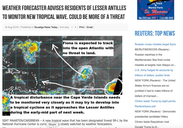
- Update
|
- By Johnefuller <johnefuller at gmail.com>
- Date: Thu, 18 Aug 2016 19:24:54 -0400
|
Sent from my iPhone
|
|
- Tropical Wave
|
- By Daniella Seepaul <daniellaseepaul at gmail.com>
- Date: Thu, 4 Aug 2016 14:11:09 -0400
|
|
Hi All,
It's a wet, cold, rainy day in Antigua as a tropical wave (Ex 96L) makes it way through.
Antigua and Barbuda Meteorological services has issues a flash flood watch for low lying and flood prone areas of Antigua, Barbuda, Montserrat, St Kitts, Nevis and Anguilla from 12 pm to 4 pm today.
Keep safe everyone!
Regards,
Daniella Seepaul
Attachment:
20160804_140503.jpg
Description: JPEG image
|
|
- RAINY WEATHER IN ANTIGUA
|
- By Martha Watkins Gilkes <marthawatkinsgilkes at gmail.com>
- Date: Sun, 31 Jul 2016 09:17:59 -0400
|
| HAPPY SUNDAY TO YOU WEATHER WATCHERS WHO FOLLOW US ON STORM CARIB… AND THANKS TO GERT FOR CONTINUED SUPPORT OF STORM CARIB AS ONE OF THE BEST SITES FOR CARIBBEAN PEOPLE TO COME TOGETHER AND REPORT ON WHAT IS GOING ON IN THE ISLANDS ..
ANTIGUA HAS RECEIVED WONDERFUL HEAVY SHOWERS OF BLESSING YESTERDAY ( SATURDAY) AND DURING THE NIGHT AND AGAIN THIS EARLY SUNDAY MORNING… HOWEVER IT IS CARNIVAL TIME (MONDAY AND TUESDAY!! SO SOME ARE NOT HAPPY IT HAS BEEN POURING OFF AND ON AND WE ARE WATCHING SOME TROPICAL WAVES COMING OUR WAY. THERE IS LOTS OF TALK OF THIS BEING A MORE ACTIVE HURRICANE SEASON SO TO BE READY IS THE KEY! |
|
|
- ????
|
- By "John Fuller" <fullaw at candw.ag>
- Date: Wed, 27 Jul 2016 15:38:15 -0400
|
|
|
|
- Lovely rainy weather
|
- By Martha Watkins Gilkes <marthawatkinsgilkes at gmail.com>
- Date: Tue, 5 Jul 2016 16:38:52 -0400
|
IT IS ALREADY JULY 4th! Not celebrated by Antiguans but we “transplanted Americans” still honored our country yesterday— raising the American flag over the COCONUT TREE! … and as of the last few days Antigua has been blessed with SHOWERS OF BLESSING badly needed with tropical waves coming through… all good for our drought island! and already we are over a month into the HURRICANE SEASON which started JUNE 1st. I think people are a bit SLACK in even thinking about it and hopefully will become more prepared as time goes by and we get into the height of the season! 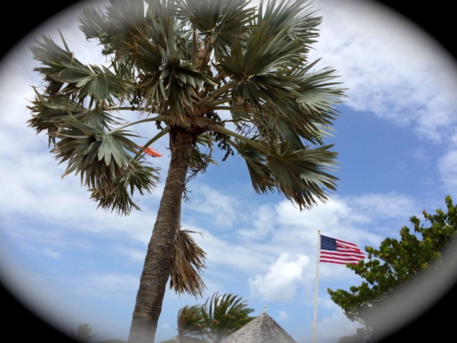 |
|
|
- Rain and more rain
|
- By Alan Scholl <scholla at candw.ag>
- Date: Tue, 7 Jun 2016 14:28:23 -0400
|
Starting around 4AM this morning, we have been drenched. It has stopped for the
last two hours but still very overcast.

Alan Scholl
|
|


![[Click on image to close window]](gif03FW0EwXkj.gif)