
|
- - - 2008 Hurricane Season - - -
|
- A very wet dry season
|
- From: "Mark and Jill" <email at grenadavilla.co.uk>
- Date: Sat, 28 Mar 2009 09:14:36 -0400
|
|
Well just as we thought dry season was finally upon
us Grenada gets more rain and the island remains green and beautiful. Last time
I remember rain this late and long was a few years ago when England came out to
play cricket and the matches were cancelled - and of course we all know who are
here playing again. Next time we get a rough dry season we should invite
England out for a few friendly games of cricket !!!
Mark
|
|
|
- We are coming!
|
- From: "John Burnie" <john at yachtindaba.com>
- Date: Thu, 12 Mar 2009 10:49:53 -0400
|
Round Grenada
Race is this Saturday! We are coming to do battle in the 18kts wind promised!!
![20090223_caribbean600_start_wright_3[1].jpg](jpgeW7aFRaKir.jpg)

With Kind Regards
JOHN BURNIE
|
|
|
- The sea surge.
|
- From: "Wild in Grenada" <Chris at wildingrenada.com>
- Date: Tue, 10 Mar 2009 12:10:26 -0400
|
|
Hi all, It has been a long time since I sent a
post.
Looking at the latest satellite images, it appears
that the winds that have caused the swell from the North have moved round to a
more NE direction. So hopefully the waves that have affected Grand Anse and
the other beaches down towards Point Saline, should ease off over the next day
or so.
Hogan
|
|
|
- This is what the experts say about the current weather.
|
- From: "Wild in Grenada" <Chris at wildingrenada.com>
- Date: Fri, 30 Jan 2009 09:58:17 -0400
|
BROKEN TO OVERCAST MULTILAYERED CLOUDS AND SHOWERS AND POSSIBLE
THUNDERSTORMS HAVE DEVELOPED FROM 9N TO 14N BETWEEN 60W
AND 63W...NEAR A POSSIBLE LOW LEVEL TROUGH MOVING
INTO THE SOUTHEASTERN CORNER OF THE AREA.
We are slap bang in the middle of that! Hogan
|
|
|
- Dry season, what dry season?
|
- From: "Wild in Grenada" <Chris at wildingrenada.com>
- Date: Fri, 30 Jan 2009 07:12:07 -0400
|
|
Hi friends of Grenada,
Even before last night we had a full water tank and
the pool was up to it's high level. Now the tanks is overflowing and the pool is
2 inches above it's proper level, We will have an infinity pool soon! It has
rained most of the night and is currently (07:00) raining very heavy. The
satelite images do not give me much hope of it stopping yet.
No need to water the garden for a
while!
All the best.
Hogan of Grenada
|
|
|
- Happy New Year from Grenada
|
- From: "Wild in Grenada" <Chris at wildingrenada.com>
- Date: Sun, 18 Jan 2009 07:17:31 -0400
|
Happy New Year to all of
you from, Grenada.
I see there have been no posts, on the Storm Carib
site, for Grenada since Nov 28th, probably
because it has been average weather for this time of year, until the last two
days. Friday was beautiful, see the photo taken at The Estuary Restaurant and
Bar, at Simon, or Seamoon, just off the road to Pearls Airfield from
the traffic light bridge. Look at that blue sky, just as the camera took it, no
touching up.
Who could have known how much it would change
by Saturday. Heavy and mostly persistent rain from late morning to
late afternoon, with a brief bit of sun in the middle of it. Some fresh
soil that we had dug has been washed away!
I was stopped and asked if I knew this weather was coming, the
answer was no. I thought we may have had some rain, but no where near this
amount. It appears that Grenada got caught where some warm humid eastilies hit a
westerly moving system. It clashed over Grenada. bringing, I guess, about 3
inches of rain, maybe more, (going by the level of the swimming
pool).
Today, Sunday, we are going to a beach party on Grand Anse. We have had a
few small showers, so far. I hope it improves for the rest of the
day.
All the best to all of you for 2009
Hogan of Grenada
You have been sent 1
picture.
IMG_0532.JPG
These pictures were sent with Picasa, from
Google.
Try it out here: http://picasa.google.com/
|
Attachment:
IMG_0532.JPG
Description: JPEG image
|
|
- Hurricane season all but finished.
|
- From: "Wild in Grenada" <Chris at wildingrenada.com>
- Date: Fri, 28 Nov 2008 14:10:00 -0400
|
|
Hi all,
Well we are ending the 2008 season, and we in
Grenada have been lucky.
Other countries have not been so lucky. Haiti has
really been clobbered. But most of their damage there has been caused by
heavy rains, made worse by the deforestation, causing really bad
floods and crops to be washed away.
I hope Grenada takes heed of what has happened in
Haiti. Any deforestation is bad, even small areas cleared create wash off of top
soil. It would be nice if the powers that be, could put more restrictions on
removal of vegetation.
Today we have been hit by a sudden burst of medium
- high overcast skies. This seems to have shot out from a stream of weather
stretching from just south of Tobago out ENE into the Atlantic. If this weather
continues in our direction, I guess we could have a bit more rain and more cloud
in the next couple of days.
All the best
Hogan
|
|
|
- Fw: Max weather Nov. 27, 2008, Happy Thanksgiving ... 1900Z
|
- From: Nealon Newton <nealondpo at yahoo.com>
- Date: Thu, 27 Nov 2008 18:19:25 -0800 (PST)
|
These updates are very enlightening-so I thought I share the experience.
On a different note; we now have the Trade winds and those trade wind alarms are working already. Not actual alarms but practically so. Cause everytime the northeasterlies start prevailing the kites startes singing. Don't know if its a usual thing anywhere else, but here in Corinth I can hear two singing, and by the sound of things it seems like winds are a bit gusty up there (60-100 ft above ground)
signature:peace and blessings 
--- On Thu, 11/27/08, MaxWeather at aol.com <MaxWeather at aol.com> wrote:
From: MaxWeather at aol.com <MaxWeather at aol.com>
Subject: Max weather Nov. 27, 2008, Happy Thanksgiving ... 1900Z
To: MaxWeather at aol.com
Date: Thursday, November 27, 2008, 2:00 PM
As the season winds down some areas are cooler, windier and best suited for the most knowledgeable cruisers and pilots.
Most causes for weather events seem to be off shore Atlantic. In the NE a low kicking up gale force winds just off shore the Maritimes and in the Mid-Atlantic, 45 W 34 N moving east at 5 mph is a massive controlling low associated with a cold front pushing nasty weather east between the Canary and Cape Verde Islands.
This same low has dumped cooler temps and pretty impressive winds to the South and southwest from the Bahamas, PR, VI and most of the Lessor Antilles kicking up waves along most all north and east face land masses.
In the interior Caribbean, a stationary low over Panama is sucking in winds from the East and blasting the central Caribbean and ABC's on a pretty regular basis. None of these irritating winds are likely to subside for the next 48 hours.
Very likely that rough waters make navigation a bit on the nerve racking side but just another day for the seasoned veterans but never take anything for granted and keep the hatches closed tight!
With all the shearing steering winds aloft over the Caribbean remember that the ITCZ is still producing a line of convection sliding under along the surface to the West along the prevailing Easterlies carrying a good amount of moisture as it nears the TnT and Windward Islands.
Because the winds aloft are pulling to the Northeast, expect isolated buildups not only along the southern Caribbean but eventually up along the Windward to the Leeward Islands over the next 72 hours with some scattered isolated heavy showers along with cooler temps. Seems like paradise to me?
Because the season ends in the next few days means nothing as we are not in charge of closing the Dang door! As winds aloft change direction and subside the last of the surprises of the ITCZ are yet to come so .......
Always keep an eye to weather and be safe out there. Max
Charts, pictures and some scary satellite images:
Surface Prog Chart:
Wave action as a result of surface winds:
A few satellite images:
Sites:
Crown Weather:
Sea surface conditions:
Storm Carib:
Have a wonderful day and if you celebrate Thanksgiving, have a feast!
Always remember red sky in the morning sailors take warning!
|


|
|
- Fw: Southern Caribbean Weather Extra. Nov. 20, 2008
|
- From: Nealon Newton <nealondpo at yahoo.com>
- Date: Thu, 27 Nov 2008 06:26:50 -0800 (PST)
|
This was sent to me a few ays ago but I only just now got it so I thought I would still share. This explains what was happening in our weather on the week of the 17th-started Friday the 14th-and is still likely to happen.
Grenada had large amounts of infrastructual damage during the seven days of heavy rains.
signature:peace and blessings
--- On Thu, 11/20/08, Bullwinkle41 at aol.com <Bullwinkle41 at aol.com> wrote:
From: Bullwinkle41 at aol.com <Bullwinkle41 at aol.com>
Subject: Southern Caribbean Weather Extra. Nov. 20, 2008
To: Bullwinkle41 at aol.com
Date: Thursday, November 20, 2008, 12:39 PM
After reading several island blogs I was surprised to see that many in the Southern Caribbean were unaware of what is happening during the beginning of a normal rainy season. It is anything but normal! Persons are dying in floods, mud slides, autos washed off of roadways, and boulders or houses are falling down hills. Very dangerous. On some islands entire communities are dealing with total devastation.
My usual e-pals are cruisers that have been boat bound with hatches and ports locked closed to keep out days and days of near constant heavy rains.
From my perspective many miles away I just wanted to advise some of you not normally on my little mailing list that conditions are NOT going to improve soon. At least not within the next 72 hours if my information is correct and I assume it is for now.
The whole picture across the entire southern Caribbean is this: There is a ridge of high pressure pushing a blanket of cold air behind a cold front that extends from Honduras to Puerto Rico and beyond compressing warm moist easterlies in the souther Caribbean and lower Lessor Antilles.
Though the entire region is covered high above with strong upper level westerly wind shear, it is not having an impact on the low level moisture filled winds off the ITCZ Atlantic and southeastern Caribbean. All it is doing it tearing off the tops but leaving the compressed air saturated with moisture and it is going to fall somewhere?
National sources, for the most part only advise or warn of tropical conditions that MAY result in a tropical storm or worse, a hurricane. Though most agree, water is the most dangerous impact of unwanted weather systems but just because it is going to rain they don't try to predict excessive amounts! They would be more concerned with storm surge or tidal waves.
Conditions all along the southern most Caribbean and eastern islands mostly to the south of Antigua and Barbuda will not get either a surge or tidal wave but will continue to receive extraordinary rain falls endangering many on soft or sloping terrain islands. The ground can only accept so much rain before it saturates and then it floods or moves taking whatever with it!
The ridge across the central Caribbean is slow to move to the south and east as it's leading edges push up the warm moist winds and encourage more and more rains. Probably to make matters worse in the Windward Islands are a tropical wave at 52 W spanning from 7-15 N slowly creeping to the west beneath the shearing steering winds aloft.
For the foreseeable future, 72 hours at least, torrential isolated rains will occur anywhere in the concerned area slowly migration up to the southern Leeward Islands within a few days. There is a lot of fuel for convection
in the form of moist air and warm water over the entire southern Caribbean.
I am only providing you this information as so many don't know this is happening or is about to happen to them?
It would be appropriate you share significant weather related information to those that may not suspect the dangers of continued rains, it can and does kill.
In another regard, vessel deliveries and cruisers to the Bahamas and Caribbean from the N. US and Europe are on an indefinite hold as the N. Atlantic north of 35 N is flatly dangerous! High seas and gale force winds prevail and will continue for some time to come. There will be a window of opportunity but patience is the rule for now.
Always keep an eye out to weather and be safe out there. Max
To assist you in having an better understanding of what is going on, it does not take rocket science, you will find the Tropical Surface Prog Chart below.
Monitor all sources of weather information and forecasts and have a wonderful day .... Please be safe.
|


|
|
- I think that weather has gone!
|
- From: "Wild in Grenada" <Chris at wildingrenada.com>
- Date: Sat, 22 Nov 2008 07:15:24 -0400
|
|
Hi all,
After 1 week of bad weather, it loks as if we are
going into a drier patch now. Yesterday wasn't bad, but there was still very
little sun. The satellite images show the much drier weather has almost
reached us.
We drove round the island yesterday, hit some rain
on the west side, stopped at 'The Heights' bar and restaurant, near
Sauteurs and had a good view up through the islands, Union was clearly
visible, from there. On to Bathway, plenty of people enjoying themselves on the
beach. Then back via 'The Estuary bar at Simon. An accident on the coast road at
Marquis made us change plans and drive over Grand Etang. Stopped at Grand Etang
House (car over heated!), we and the car had a drink! Only as we got back to
Springs did we see more rain.
This morning has
started fine.
All the best
Hogan of Grenada
|
|
|
- I have been asked how much more rain?
|
- From: "Wild in Grenada" <Chris at wildingrenada.com>
- Date: Thu, 20 Nov 2008 12:58:33 -0400
|
|
Hi all,
After a slightly better day yesterday (I did say
slightly). We are back with rain and overcast again today. The one week tourists
that arrived, and got wet leaving the aircraft, last Friday, will be happy
to get back on the plane tomorrow. But be warned, I believe the UK is in for
artic blast this weekend!
I have received an email asking when is the rain
stopping? Well I have my piece of seaweed and it still looks pretty soggy. The
humidity at Pt Saline is 94% as I write. Looking at the satellite images, we
seem to be in (believe it or not) a relatively dry patch between a big blob to
the NW and what hopefully is the last of this weather to the SE. But there is a
small protrusion coming out of the NW area, straight towards GND, causing the
rain as I write.
About 300 miles out in the Atlantic is an area of
drier air, so hopefully in the next couple of days, if this weather can move
West, as it is traditionally meant to, we should have some better weather.
But too late for the tourists I mentioned above!
All the best,
Hogan of Grenada
|
|
|
- AND THE RAIN CONTINUES
|
- From: Caron Juerakhan <indiabella82 at hotmail.com>
- Date: Wed, 19 Nov 2008 22:48:17 +0000
|
HI ALL
DAY NO 5 AND NO SIGNS OF LETTING UP ANY TIME SOON. AT LEAST IN THE ST. JOHN'S AREA. THE SUN ACTUALLY CAME OUT TODAY FOR A FEW HOURS BUT AROUND 5 PM THE RAIN STARTED AGAIN AND HASN'T LET UP SINCE AND IT'S AFTER 6:30. WITH THE AMOUNT OF WATER FLOWING IN THE RAVINE UNDER OUR BRIDGE I CAN TELL YOU THAT IT'S A LOT OF RAIN. MY NEIGHBOUR'S HAVING SOME WORRIES WITH HER BACKWALL. THE RAVINE IS UNDERMINING THE SOIL AS IT RUSHES DOWN ITS PATH. I CAN TELL YOU THAT'S CAUSING HER SOME REAL HEADACHE.
AT LEAST ONE SECONDARY SCHOOL (ANGLICAN HIGH) AND THE T.A. MARRYSHOW COMMUNITY COLLEGE (TAMCC) HAD TO BE CLOSED TODAY BECAUSE OF PROBLEMS WITH THE WATER SUPPLY. AS FOR THE WEST COAST, PART OF THE ROAD LEADING TO BRIZAN HAS BROKEN OFF AND ONE HAS TO BE VERY CAREFUL WHEN PASSING THROUGH. A HUGH TREE FELL ON THE CORNER AT WHITE GATE, BUT THAT HAS BEEN CLEARED UP.
SO I GUESS WE'LL JUST HAVE TO WAIT AND SEE WHAT HAPPENS NEXT. HOPEFULLY, THE RAIN WILL LET UP LATER OR TOMORROW, ALTHOUGH MORE RAIN IS IN THE FORECAST FOR US FOR THE REST OF THE WEEK.
STAY SAFE AND DRY Y'ALL.
CJ
Get news, entertainment and everything you care about at Live.com. Check it out!
|
|
|
- link
|
- From: Nealon Newton <nealondpo at yahoo.com>
- Date: Wed, 19 Nov 2008 12:21:46 -0800 (PST)
|
A link to the attachment I was suppose to attach.
signature:peace and blessings |
|
|
- De Ja voo !
|
- From: Nealon Newton <nealondpo at yahoo.com>
- Date: Tue, 18 Nov 2008 15:55:43 -0800 (PST)
|
Day 5 and counting since we've been getting heavy rains. At times when it comes down it does in torrents but today (tuesday) and monday night proved to be Deluges. It was like "RAIN SQUARED".
Today clouds were building on hills that is just 50 to 60 feet above sea level. Theres lots of land slipages that came down with huge trees, blocking roads and bringing down lines. (Not power lines though).
Theres quite a few areas of the island where water service is interrupted. But there were no reports of power outages.
As to what is causing this weather. I'm no expert-but I believe its a rear event where a detached (from the low pressure system) frontal boundrary is interacting with the ITCZ and combined with the strong upper level winds embedded in our territory is making the atmosphere very unstable.
In the attachment; see how far north low pressure has gripped. It shows how far north the ITCZ has gone. Pick out the ITCZ where north winds meet south winds. (the arrows represent the winds).
As Hogan predicted, I do concur that it will continue for a while. Unless surface pressure makes a drastic shuffle over the Atlantic ocean we will remain unstable here in the south and we can look out for more of the same.
Meanwhile I'm absolutely loving it all, the flash flooding, the pounding rain and the high winds. Afterall its not everyday that we get rain for 5 days and counting in paradise.
Stay dry Grenadians (if you so choose)
signature:peace and blessings |
|
|
- Msg from Trinidad!
|
- From: "Wild in Grenada" <Chris at wildingrenada.com>
- Date: Tue, 18 Nov 2008 18:50:12 -0400
|
|
Just received this from someone n
Trinidad!
Hi Chris
We are in Trinidad for the day, and it's as bad here. The
traffic is solid because so many routes are flooded. We may not reach the
airport in time!
Cheers Robin
Hogan.
|
|
|
- Not really sure what is causing this weather.
|
- From: "Wild in Grenada" <Chris at wildingrenada.com>
- Date: Tue, 18 Nov 2008 17:20:30 -0400
|
|
Hi all,
Great to see all the reports coming in to Storm
Carib. During my travels today I only saw one land slide near Woburn Junction on
the road to the Cliff. There was minor flooding (still passable) in the
Spiceland Mall area.
Have looked at the satellite photos and various web
sites. And it appears that this weather is locked between North of Tobago and
South of St Lucia, with Grenada apparently getting the worse. The bright sky
that we have seen to the south of us (when the rain is not blocking it out) is
quite clear on the satellite images. What ever this is (a front, a wave, or part
of the ITCZ) it doesn't seem to want to move. To my untrained eye, it seems the
Inter Tropical Convergence Zone (ITCZ) has moved further north than usual. Look
at the Satellite loop http://www.ssd.noaa.gov/goes/east/tatl/loop-avn.html and
you will see what I mean. It seems to spread all the way across the Atlantic.
As I said, this kind of weather is normally a couple of hundred miles
further south. You can also see on the images the drier warmer weather further
up the chain.
I hate to say this, and this is one of those times
I really want to be wrong, but it looks like we could continue with this for a
while yet.
So now (17:17) it is still raining (not heavy).
Pool is cold and again has too much water in it, the water tank is cold. The
tree frogs are happy, and will soon be singing louder than ever.
All the best
Hogan
|
|
|
- WET, WET,WET.
|
- From: Caron Juerakhan <indiabella82 at hotmail.com>
- Date: Tue, 18 Nov 2008 17:37:26 +0000
|
Hi everyone,
And it's pouring down again. I'm holed up at home (sick leave) so I can't move around but from what I can see from my balcony, the soil is very waterlogged. There's a bit of landslide in front of our house and the ravine under our bridge is flowing like an angry river and is taking away some of the soil with it, as usual. It's quite cloudy and dark and it seems that we'll have more rain coming and there's a tropical wave in the vicinity(?). I was told that the Mt. Parnasus Road is impassable and that there's a major landslide on Marrast Hill.
I hope that everyone gets home safely and that there'll be no accidents. Let's hope for the best.
chao, CJ.
Connect to the next generation of MSN Messenger Get it now!
|
|
|
- landslide pics
|
- From: "storm tracker" <grenadatracker at gmail.com>
- Date: Tue, 18 Nov 2008 10:43:02 -0400
|
I took a quick drive around St. George's Parish to see what kind of damage the rains have brought. There are a lot of small land slippages that are partially blocking roads. The Sendall Tunnel is flooded (as usual). I didn't see much to take a picture of on river road, but I could see evidence that the high water mark was about 2 feet higher than it was when I was driving through there. I have no doubt the river was over it's banks through the night. I didn't find the house that had the pool slide down the mountainside in Grand Anse, and with gas at nearly $16 a gallon, I wasn't up for going too far off the beaten track looking for it.
Anyway, based on the distribution of landslides I saw this morning, the dryforest area of Grenada (South, Southwest) seem to be taking the most damage.
The National Water and Sewage Authority has issued notices for quite a long list of parishes that are without water today and are likely to have service interrupted for days. One area I recall being mentioned was damage done to the Anandale dam (or piping to the dam, or something like that). We still have running water at our house, but it's so brown, it's not worth drinking even if it were boiled.
As far as I know, electricity is ok.
Attachment:
Egmont, St. George's.jpg
Description: JPEG image
Attachment:
Yard Slippage, St. Georges.jpg
Description: JPEG image
Attachment:
Marian, St. George's.jpg
Description: JPEG image
Attachment:
Tanteen Pedestrian Sign.jpg
Description: JPEG image
Attachment:
Woburn, St. George's.jpg
Description: JPEG image
Attachment:
Sendall Tunnel.jpg
Description: JPEG image
|
|
- Deluge
|
- From: "storm tracker" <grenadatracker at gmail.com>
- Date: Tue, 18 Nov 2008 08:47:45 -0400
|
While driving my husband to work this morning, I was shocked to see the ammount of damage caused by the rains last night. I'm heading out in my car with a camera to capture the damage. I saw one house that had a land slippage so severe, the house is perched on about 2 feet of soggy unstable looking frontage now (Calivigny). Someone I know said a pool nearly ended up in his livingroom last night (Grand Anse).There's considerable road damage (debris, trees down in the roadway, road breakage). As for the guestimate of how much rain we had...I had a bucket placed on my balcony (covered balcony) and the bucket caught 2 inches of rain with what was blown under the roof....so imagine we probably got closer to three inches if not more? Will check with Point Salines later.
Where's NaDMA?
|
|
- We don't seem to be out of this band of weather, yet.
|
- From: "Wild in Grenada" <Chris at wildingrenada.com>
- Date: Tue, 18 Nov 2008 07:28:31 -0400
|
Good morning Grenada, and friends.
Here are a couple of photos to remind us of the weather over the last few
days!
Well, last night saw another 2 inches of rain, I
guess. And although the patch of heavy cloud that has been over us most of
the night is breaking, we still seem to be in this same band of weather. It is
spreading out to the East. It looks as if Grenada has had more rain
than any other island, and maybe more to come.
The inlets below us are completely brown with
run-off. This is made worse by thoughtless land clearance. The trees, scrub and
topsoil act as a sponge. When removed, any rain will just wash the soil away,
into the drains and straight into the sea. The silt then kills the coral, and
thus the habitat for fish.
I do not understand why a complete lot has to be
cleared to build a house. The trees and scrub give protection to the top
soil, they also give the ground protection from the sun, thus making
the area around the house cooler. It also gives a habitat for wildlife. Slowly
the scrub can be replaced by the plants we want in the garden. Why do we all
think it is someone elses problem to protect the environment and not
ours? Every little helps. Remember how hot it was after Ivan, that wasn't
due to the weather it was due to the lack of trees and plants absorbing the heat
of the sun. Where do we go if we are hot? Into the shade of a tree!
Sorry for the lecture. Happy to hear your
comments.
Hogan of Grenada (looking forward to seeing the sun
again)
You have been sent 2 pictures.
IMG_0043.JPG
The brown inlets
IMG_0042.JPG Rain drops
These pictures were sent with
Picasa, from Google.
Try it out here: http://picasa.google.com/
|
Attachment:
IMG_0043.JPG
Description: JPEG image
Attachment:
IMG_0042.JPG
Description: JPEG image
|
|
- For once my predictions were spot on.
|
- From: "Wild in Grenada" <Chris at wildingrenada.com>
- Date: Mon, 17 Nov 2008 11:29:56 -0400
|
|
Hello Grenada!
Two days ago I predicted it would be cloudy and
wet, and this time I was correct. Makes a change! The only part of my
prediction that was wrong was I said we would be having luke warm water - it is
COLD!
The pool is down to 26.5C, the coldest in well over
a month - easily!
I am really feeling sorry for the tourists that
arrived on the BA flight on Friday. Their plane arrived and were disembarking
when the rain started. I hear many got wet. And they have hardly seen any
sun since arriving. If any of them read this, what we are having is very very
unusual. This is the first time in 4 years that we have run out of hot, solar
heated, water! Still I nearly have a full cistern of water, having emptied it 6
weeks ago filling the swimming pool.
The weather we are having is all part of a
weak tropical wave. As I write, the worst seems to be just north of us, but
wanders out to the east in the Atlantic. As with all tropical weather, it is a
bit unpredictable. It may fizzle out, or the wave may drift down and give us
more overcast/wet weather.
Overnight and this morning we have had just under 2
inches of rain (the pool has risen this amount). I am currently in the process
of siphoning off some to bring it down to the skimmers.
For interest the temperature in various islands, as
I write, is:
Antigua - 27C 80F
Barbados - 27C 80F
Dominica - 31C 87F
Martinique - 31C 87F
St Lucia - 31C 87F
St Vincent - 28C 82F (on the north edge of
this weather)
Grenada - 26C 78F
Tobago - 29C 84F
So we have the worst of the weather (at the
moment)!
Still we don't have to water the
plants!
All the best
Hogan of Grenada
|
|
|
- A change in the weaher
|
- From: "Wild in Grenada" <Chris at wildingrenada.com>
- Date: Sat, 15 Nov 2008 06:53:12 -0400
|
|
Good mornng,
For the last couple of days the weather has
changed. We now have the trade winds back. Sleeping at night is much
easier.
Looking at the satelite pictures, I feel we are in
for some overcast days, maybe further ran. If it is as I predict, we will be
running on luke warm water in a couple of days. The process speeded up by having
4 people in the house. The pool is getting colder each day, partly due to the
wind and rain and partly due to it not getting much sun during the
day.
There is a small tropical wave just off to the east
that is adding to the amount of cloud that I am expecting. The National
Hurricane Centre doesn't give this wave much chance of developing, but could
still give us some weather.
Have a nice weekend.
Hogan of Grenada
|
|
|
- Paloma - now Cat 4, here dead calm!
|
- From: "Wild in Grenada" <Chris at wildingrenada.com>
- Date: Sat, 8 Nov 2008 18:11:22 -0400
|
|
Hello Storm Carib and Grenada friends.
Well as we watch a beautiful sunset with skies
clear enough to see Venezuela very clearly, I think we should think of the
people of Cuba that are just about to get clobbered by Hurricane Paloma which
has jumped to a Cat 4. Also think of the people of Cayman Brac and Little
Cayman, both of which are through the storm, but with a lot of
damage.
All the best to you all, and enjoy the peace and
quiet of Grenada. And don't complain if it is hot and still tonight, it won't be
in parts of Cuba!
We are now off to a meal at the Little
Dipper.
Hogan of Grenada
|
|
|
- Hurricane Paloma
|
- From: "Wild in Grenada" <Chris at wildingrenada.com>
- Date: Fri, 7 Nov 2008 06:30:25 -0400
|
|
Tropical depression 17 has now developed into
Hurricane Paloma, in the far Western Caribbean. It appears to be no threat to
us, and is twice as far away as Omar was, which caused the sea surge about 3
weeks ago. It;s path is predicted to go North, through Cuba and towards the
Bahamas.
The weather here (06:25) is calm. We have had
a stuffy night. Looking out I see a few slow moving showers to the
East.
So, for now, we seem to be back to this years norm
of little breeze and few showers.
All the best
Hogan of Grenada
|
|
|
- Grand Anse seems fine.
|
- From: "Wild in Grenada" <Chris at wildingrenada.com>
- Date: Tue, 4 Nov 2008 07:05:13 -0400
|
|
Grand Anse Beach, near Real Value seems fine now.
We had a swim there yesterday, and the beach looks fine and the water was
clear. The car park seems to have been enlarged. There is one poor
tree (Almond), trying to grow. It what is now needed is a row of trees between
the carpark and the beach to give shade. Almond trees are perfect, they
grow fast and give good shade.
Really fine weather at the moment. The horizon is
very clear with large ships easily visible passing between us and Trinidad. It
is not quite clear enough to see Venezuela though.
There is a weather disturbance (93L) in the far
west of the Caribbean, with potential to develop, but not likely to cause us any
concern.
Interesting post from Jaquie, about the
lightning.
Hogan of Grenada
|
|
|
- Too close for comfort!
|
- From: jacqueline dowden <jacquiedowden at hotmail.com>
- Date: Thu, 30 Oct 2008 17:47:08 +0000
|
Hi everyone,
Lucky or what? Last night, as Hogan has said, we had some heavy rain but the lightening was just too close a call.
My husband was in the kitchen cooking and thought the gas tank (empty I might add) on the back veranda had exploded, I was on the computer and looking toward the back door and saw an empty metal dog bowl jump in the air (thank goodness the dogs had finished eating), a huge flash of light and the sound of an explosion. This morning we found out that our next door neighbour lost his Cable box, his TV was smoking as was his stereo and his uninterruptible power supply (UPS) was interrupted.
That is definitely too close for comfort.
Jacquie
Explore the seven wonders of the world Learn more!
|
|
|
- Coconut Beach looks fine.
|
- From: "Wild in Grenada" <Chris at wildingrenada.com>
- Date: Thu, 30 Oct 2008 06:44:31 -0400
|
|
Went for a swim at Coconut Beach (Grand Anse) and
it looks fine. This part of Grand Anse seems to have recovered well.
Please send me updates on any of the beaches you
visit and I will forward them.
Plenty of short showers during the night, here in
Westerhall, and many more visible as I type this. Looking at the various web
sites, it appears that we have the trade winds back (for the time), the Atlantic
appears calm, except for a blob half way across, at about our Latitude. NHC
gives this area of 'weather' less than 20% chance of developing in the next 48
hours, although it has been designated 92L. The few model plots, show 92L
travelling NW, at the moment. I will monitor this.
Hogan of Grenada
|
|
|
- Update on the Beaches
|
- From: "Wild in Grenada" <Chris at wildingrenada.com>
- Date: Sun, 26 Oct 2008 12:37:38 -0300
|
|
Hi all,
Sorry for the delay, could not get a connection for
most of yesterday.
I did a tour of the beaches, from Grand Anse to the
Aquarium beach. This was on Friday, so please take this as one day out of
date.
Grand Anse, near Spiceland Mall - is missing
a lot of sand. Also bits of coral at the waters edge, rolling in the waves..
Mourne Rouge - covered in seaweed, the first 30 ft
of sea full of flotsam and jetsam, less sand than usual, and a smell of seaweed.
Really needs raking.
Beach House - eroded so that palm trees have their
roots visible, also large lumps of coral where the waves hit the
beach.
Dr Grooms - not bad at the North end, badly eroded
at the south end (Clay and rocks easily visible where there used to be sand.
Also some trees washed away and many branches and tree bits half buried in
the sand. Upper beach has been raked and looks OK.
Aquarium Beach (public car park) Was being tidied
while we were there. Much sand had gone.
At all the beaches the water looks very millky,
this could be due to the heavy rain in the last 3 days, rather than
the surge.
Also a photo of a water spout, seen Saturday afternoon, just off the South
coast, near Westerhall.
At 07:35 today, Sunday, it is a lovely morning, very calm. The sun is
shining, although there is some hazy high level cloud.
Enjoy the rest of the weekend.
Hogan of Grenada
You have been sent 1
picture.
IMG_9726.JPG
These pictures were sent with Picasa, from
Google.
Try it out here: http://picasa.google.com/
|
Attachment:
IMG_9726.JPG
Description: JPEG image
|
|
- Floods.
|
- From: jacqueline dowden <jacquiedowden at hotmail.com>
- Date: Thu, 23 Oct 2008 21:23:22 +0000
|
I have put off going down to Grand Anse since Tuesday because of all the rain we have had and foolishly (couldn't leave it any longer) decided to go today. Big mistake!!!! I'm lucky to have gotten out of the Spiceland Mall without a boat. I waited by the car park entrance hoping a bus would pull in and waited and waited.... the lucky bit was that a bus driver was in the Mall and his bus in the car park. By this time the car park was completely flooded, one car had got stuck with his two offside wheels in a drain (who would know the drain was there!!). I have to say I have never been on a bus travelling so slowly as we crept through the car park and out into the river.... hmmm I mean of course the road!!! Once we were up on the main drag it was clearer but we did encounter some mud slides and lots more water along the road to Town.
We now have some sunshine but the clouds are building again.
Jacquie
Get news, entertainment and everything you care about at Live.com. Check it out!
|
|
|
- Rain - more rain.
|
- From: "Wild in Grenada" <Chris at wildingrenada.com>
- Date: Thu, 23 Oct 2008 10:10:01 -0300
|
|
09:30 Thursday,
Well Having been watching the satellite images this
morning, the big blob has just hit us. We are on the western side of what looks
like some miserable weather that stretches across the Atlantic for some
distance. I believe this is an area called the ITCZ or Inter Tropical
Convergence Zone. Normally this is a little further South, but a tropical wave
about 600 hundred miles out in the Atlantic seems to be pulling this area
North. If the satellite images are correct it looks as if we could
have some grim weather for a good part of the day. Having said that this weather
does not stretch very far North, St Vincent appears to be just North of this
weather, also Barbados is on the edge of it.
To try to understand the Infrared images, the light
grey to white is low level clouds, then passing through the yellow,orange,
reds to dark grey shows a decrease in temperature, which corresponds to the
height of the cloud tops. The dark brow, red and dark grey, are often the
tops of towering thunder, or at least heavy rain, clouds. This isn't always
the case though; as I said it is an indication of height of the tops of the
clouds, sometimes there can be a high layer of cloud with little or no
rain. Yesterday afternoon was a case of this.
I hope this makes some kind of sense. An expert
would probably cringe at my explanation.
Unfortunately we do not get weather radar from
Grenada, this would give a much better indication of rain. Google earth weather
shows this very well in areas where there is radar coverage.
All the best, try to have a nice
day!
Hogan of Grenada
|
|
|
- Rain - maybe more?
|
- From: "Wild in Grenada" <Chris at wildingrenada.com>
- Date: Wed, 22 Oct 2008 08:14:10 -0300
|
|
It has been raining for almost an hour now. Looking
at the satelite images, this blob of weather started in Barbados at about 02:00
this morning. It slowly built to, what appears, quite a blob, which is generally
moving in this direction. It currently (at 08:00 this morning) appears to spead
NE for about 150 miles, and is still building. As with weather here, it
may disappear as quickly as it comes. But for the time being, I would expect
quite a bit more rain, this morning. I have just unplugged my laptop from
the mains, as there is thunder in the neighbourhood. Hey - that one was
CLOSE!!!
My sister-in-law, arrived last night, and
today, instead of sunshine, she is getting thunder and rain.
Hope you have a good day!
Hogan of Grenada
|
|
|
- More banging and crashing
|
- From: jacqueline dowden <jacquiedowden at hotmail.com>
- Date: Tue, 21 Oct 2008 22:27:02 +0000
|
Now that was rain!!! This morning we had loud thunder and lightening and lots of rain. OK I know 'lots' is not very technical but the ravine opposite me was running white water, of course it wasn't wide enough for rafting or I could have made a fortune from tourists this morning. I suppose it only rained for just over an hour but the heavens opened would be an understatement.
All cleared up this afternoon and sunshine took over.
Jacquie
Get news, entertainment and everything you care about at Live.com. Check it out!
|
|
|
- Beaches - update from Mango Bay
|
- From: "Wild in Grenada" <Chris at wildingrenada.com>
- Date: Mon, 20 Oct 2008 11:41:21 -0300
|
|
Below is an email I have just received from Mango
Bay:-
Hi Hogan,
also the beaches at the west coast
Moliniere, Flamingo Bay and our beach at the Mango Bay Cottages lost a lot of
sand.
We lost about 3 feet of sand and we also
lost one tree at the beach. But the sand already started to come
back.
see you soon in
Grenada...
______________________
Kai Niermann
Mango Bay Cottages
Woodford
St. John
Grenada
www.mangobaygrenada.com
|
|
|
- Just received this from Tony and Kath - thanks
|
- From: "Wild in Grenada" <Chris at wildingrenada.com>
- Date: Mon, 20 Oct 2008 10:16:34 -0300
|
|
On Saturday we were down atthe BBC - not too bad but
plenty of weed and
detrius washed up - the ususal beach
cleaners were not apparent having all
been sent over to
clear up Grand Anse first!
Yesterday afternoon on the
Aquarium beach, water very high
and up to the vegetation so much washed away
and
undermined the Aquarium terrace and steps, but otherwise
not too bad
- but so much sand has been washed away
entirely....
Hope this
helps
Tony & Kath
|
|
|
- Update on Beaches
|
- From: "Wild in Grenada" <Chris at wildingrenada.com>
- Date: Mon, 20 Oct 2008 09:29:31 -0300
|
|
Apparently, They have done a fantastic job in
tidying up Grand Anse. Most of it has been cleared up, all that is needed is a
bit of nature to sift it a bit. Well done to those responsible for the
clear-up.
Aquarium beach could be better, but is not bad. The
sea bottom is a bit mashed. And as of yesterday the sand was in steep 'cliffs'
approaching the sea. But nature is doing its bit.
So Grenada is almost back to normal.
Thanks to those that have updated me.
Hogan of Grenada
|
|
|
- State of the beaches.
|
- From: "Wild in Grenada" <Chris at wildingrenada.com>
- Date: Mon, 20 Oct 2008 05:46:43 -0300
|
|
Thanks to Paula and Jacquie for the reports about
the state of the beaches.
I have only heard about Grand Anse, which seems to
be piles of coral/sand mixture piled up along the full length of the beach, some
parts worse than others. I have not heard about Mourne Rouge Bay beach (BBC), or
the Aquarium, Doctor Grooms or Beach House beaches. If anyone can let me
know the state of these beaches, then I will pass it on. Use email at the top of
this post.
The reason these beaches have suffered is because
they are normally protected from the prevailing wind.
On the other coasts the beaches seem untouched, La
Sagesse looks fine and also Bathway.
At last, we have winds back from the prevailing
direction. Much cooler last night.
The Atlantic appears quiet, at the moment. Nothing
forcast.
Hogan
|
|
|
- Grand Mal
|
- From: jacqueline dowden <jacquiedowden at hotmail.com>
- Date: Fri, 17 Oct 2008 23:52:58 +0000
|
I have not visited any of the beaches in the last couple of days but I know the sea was coming over the sea wall along Grand Mal and by Sunset View so I would think the beaches are pretty bad there.
Jacquie
Invite your mail contacts to join your friends list with Windows Live Spaces. It's easy! Try it!
|
|
|
- Grand Anse Beach
|
- From: "Wild in Grenada" <Chris at wildingrenada.com>
- Date: Fri, 17 Oct 2008 15:03:30 -0300
|
|
Apart from the light displays, long before Omar was
even 97L, Grenada came off lightly. But I had predicted that we would get some
rough seas off the South side of Omar whn it was in Mid Caribbean, and hovering.
Well the waves arrived yesterday, along the West coast. I had reports of huge
waves breaking on Grand Anse. Well we went to the beach today and Grand anse is
just a pile of broken bits of coral and sand. we hear that it is the same along
many of the West facing beaches. Can anyone let us know the state of
beaches you have visited. Then we can let people know where to go.
The South Coast should be OK as it didn't get the
waves, but please let me know.
Hogan
|
|
|
- Now its Hurricane Omar.
|
- From: "Wild in Grenada" <Chris at wildingrenada.com>
- Date: Wed, 15 Oct 2008 11:34:49 -0300
|
|
Hi all,
Omar has started it's journey North, although,
despite the official report of it moving at 6 MPH, watching the last 5 hours of
satellite loop http://www.ssd.noaa.gov/goes/east/tatl/loop-avn.html I
see no movement at all. It looks like a trapped monster, trying to find a way
out of the chain of islands. The predicted escape route is close to
Puerto Rico. Strangely, this is where it was originally meant to go, before
it's journey South to have a look at the ABC islands.
Last night saw another light display off the West
coast of Grenada, as a street of thunder storms made their journey North,
chasing Omar. Here today, a pleasant day, with a nice breeze.
Now back to some chores!
Hogan of Grenada
|
|
|
- 97L became TD 15 now Tropical Storm Omar
|
- From: "Wild in Grenada" <Chris at wildingrenada.com>
- Date: Tue, 14 Oct 2008 15:01:24 -0300
|
|
Since my post this morning, 'Our blob', which is
still slowly moving towards Curacao, has now been officially named Omar. The
high hazy cloud we are now experiencing is the upperlevel outflow from
Omar. It is expected to turn East (yep that is our direction), but then
towards the North on Wednesday. I hope it doesn't come too close before
moving North.
Barbados is experiencing a large amount of rain
today, enough to close schools!
Have a pleasant evening.
Hogan
|
|
|
- A lovely morning in Westerhall.
|
- From: "Wild in Grenada" <Chris at wildingrenada.com>
- Date: Tue, 14 Oct 2008 09:07:57 -0300
|
|
Good morning,
What a lovely morning, very slight breeze, few
clouds.
I have been looking at the various web sites this
morning. Nana, in the Atlantic has all but been demolished by high level winds,
wind shear. But, it has produced a child of Nana (90L), It also seems to be
breaking up this morning. It is well out in the Atlantic at 14N.
What was 97L (the weather we had over us a few days
ago, is now Tropical Depression Fifteen. It has not been obeying the rules (this
seems quite common this year). It was about 200 miles South of Puerto Rico and
was predicted to turn to a NE direction, but it continued West for a while then
towards the South, and is currently moving very slowly SE. It is now 120
Nautical Miles North of Curacao, and about 350 miles west of us, in
Grenada. It is predicted to turn North again, and increase slowly into a
Tropical Storm. It is worth keeping an eye on it still. The upper outflow
is not far to the west of us. If you want to see it on the satellite animation,
see
TD15 unless it disappears, has to break out of the
Caribbean, somewhere, so where will it be? NHC predicts Puerto
Rico.
Now back to do a bit of gardening. Enjoy the
day.
Hogan of Grenada.
|
|
|
- 97L becomes Nana and 98L is looking ugly.
|
- From: "Wild in Grenada" <Chris at wildingrenada.com>
- Date: Mon, 13 Oct 2008 07:16:32 +0100
|
|
The disturbance 97L in the mid Atlantic has gained
strength to become Tropical Storm Nana. All the predictions have it going North,
but its current direction is more WNW. Even if it stays on this course, it will
clear the Caribbean.
Our own blob 98L is about 150 miles due S of Puerto
Rico, and appears to be building. Its current direction is West(just), but
nearly all the predictions turn it to the NE. Whatever, we seem to be OK here in
Grenada.
Now feel that breeze! the development of 98L
seems to have brought our easterly winds back. It was a much more pleasant
night, only disturbed by dogs barking. Hopefully a pleasant day ahead
of us.
All the best to all of you
Hogan of Grenada
|
|
|
- I stand corrected!
|
- From: "Wild in Grenada" <Chris at wildingrenada.com>
- Date: Sun, 12 Oct 2008 20:39:48 +0100
|
|
Thanks Syd,
Spelling was never my strong point, I am sure many
have noticed that in the past. Regarding the wind, well I can at least
half agree. Now that the system has moved away, we have been left with a
slight easterly breeze. This is the first evening when our, East facing,
bedrooms feel slightly cooler. So I will give you that the excessive wind was
squall but increased by what is now the prevailing wind returning. We
hope!
Back to the weather system that has been passing
through the Windwards over the last few days, and gave us that display last
night. It has now been designated 98L. and is now 200 miles south of Puerto
Rico. Keep an eye on it!
97L is still out there, struggling with wind shear.
It is not likely to be of any trouble to us. It is now at 15N and travelling
just N of West.
Here's to a good nights sleep.
And Jacquie, it is the number of seconds between
the flash of lightning and the thunder divided by 5, gives approx distance in
miles. But as I said, with last nights display, it was impossible to tell what
thunder came from what lightning.
Hogan of Grenada
|
|
|
- What a night, Oh what a night.
|
- From: jacqueline dowden <jacquiedowden at hotmail.com>
- Date: Sun, 12 Oct 2008 17:40:40 +0000
|
I can only agree with what the others have said, it was a terrific light show. I watched it all night and as Chris said there were no breaks in the lightening and thunder and my dogs will attest to that!! I was busily trying to remember how Chris had told us to work out how far away it was (as a child I always thought you just counted between the two and that was how many miles away it was, now I see it is much more technical than that) when I realised my stupidity.... it was overhead!!!
Stay safe
Jacquie
Explore the seven wonders of the world Learn more!
|
|
|
- Strobe Lights In Grenada
|
- From: "storm tracker" <grenadatracker at gmail.com>
- Date: Sun, 12 Oct 2008 10:39:18 -0400
|
Wow! Is about all I can say about the most fantastic strobe light display I've seen in years.
The storm that passed over Grenada while we slept (as best we could) seemed to carry a constant pulse of flashes...there was little to no time between one flash and the next. I don't remember any thunder, but my window was closed and the fan was on....in a vein attempt to deal with the abundance of nuisance mosquistos that live in our closets. Public health officials say the dengue risk is very low, so there's been no fogging this year - and my goodness, does it show!
|
|
- Re: The weather system stays with us.
|
- From: "S. Wells" <s.wells at spiceisle.com>
- Date: Sun, 12 Oct 2008 07:35:55 -0400
|
|
Thank you "Weatherman Wild" - another
edifying meteorological update!
You mention the word 'preasure' a couple
times and I must ask if this is a special Sunday spelling.
Maybe because it is closer to the word
'pray'! Or is it a UK spelling?
(I don't think you mind me pulling your leg,
Chris.)
The wind here seems closer to normal for
Spray Bay, but it seems more like squall-driven, than
isobar-driven. Almost always greater
than 20 mph with much higher gusts.
Time will tell.
The NOAA time-sequence/satellite analysis
shows clearly there was a great area of
heavy rain over Grenada at 6:45 AM. and
the air mass movement right now is from
south-southwest to NNE. Unusual!
Thanks again,
Syd
|
|
|
- The weather system stays with us.
|
- From: "Wild in Grenada" <Chris at wildingrenada.com>
- Date: Sun, 12 Oct 2008 07:12:24 +0100
|
|
The low preasure trough (can't call it a wave as
waves move) is still with us. Creating a very impressive light display at 05:00
this morning. I sat and watched it for some time and the longest gap in
lightning was about 3 seconds. During all the time I watched, I never saw any
fork lightning, only sheet or cloud lightning (probably due to it being blocked
by rain). It was also impossible to tell how far it was away as there was so
much lighning and thunder (fairly distant from Westerhall) that one couldn't
tell which thunder belonged to which lightning. From the direction of most of
it, I guess it was brighter and louder from St Georges north towards
Victoria.
For those that are interested this is what the NHC
say about this system:-
THE TROPICAL WAVE IS ALONG 66W S OF 19N MOVING W NEAR 10 KT.
THIS WAVE
HAS PUSHED TO THE W OF A 1008 MB SURFACE LOW LOCATED
IN THE E CARIBBEAN NEAR
14N64W. SURFACE OBSERVATIONS AND A ASCAT
PASS DEPICTS COUNTERCLOCKWISE
CURVATURE ALONG THE WAVE AXIS.
SCATTERED MODERATE TO ISOLATED STRONG
CONVECTION IS FROM 11N-15N
BETWEEN 60W-64W.
I hope you are now wiser!
Anyway, it has brought easterly winds back, for the
time, although I feel this is just a temporary condition as the higher preasure
to the east tries to fill the low preasure trough. As I finish this post
(07:06) the wind is really picking up, considerably higher than 14 mph from
Point Saline at 06:00!
Further afield, 97L does seem to be obeying the
computer predictions. The blob seems to have moved a little North, it is now
about 1600 miles due east of Antigua.
All the best folks, maybe some better weather
soon.
Hogan
|
|
|
- The unusual weather continues.
|
- From: "Wild in Grenada" <Chris at wildingrenada.com>
- Date: Sat, 11 Oct 2008 19:34:49 +0100
|
|
19:20 Saturday evening:
It has started to rain again. Earlier this
afternoon I watched a very strange dark cloud roll in from the south and moved
north toward St Georges. This is all part of the same weather system that has
been over us for the last few days. Well at least we had some breeze today,
although mostly from the south. Apparently this system is due to move slowly NW,
towards Puerto Rico.
Meanwhile 97L is still out in the Atlantic and
struggling to get a single area to revolve round. NHC still give the system a
20-50% chance of developing. It is still predicted to move in a NW direction,
which should take it North of the island chain.
Just over a week ago I filled our swimming pool,
directly from the water cistern. This left the cistern almost empty. Well this
weather has already half filled the cistern, without using any mains
water.
All the best.
Hogan
|
|
|
- 97L and our own disturbance.
|
- From: "Wild in Grenada" <Chris at wildingrenada.com>
- Date: Fri, 10 Oct 2008 21:50:51 +0100
|
|
Well, looking at the various web sites we see that
97L has been uprated to 20-50% chance of developing into a tropical storm.
Currently all predicted paths take it on a Northery corse, harmlessly (unlass
you are a small boat) up the Atlantic.
I just had a pleasant evening with friends at a BBQ
at Aubreys, the talk there was how little wind there has been for some
considerable time.
The strange weather we have had the last couple of
days, seems to be not far away, it has just moved further north, and has been
designated as an area with less than 20% chance of developing! 97L was that
yesterday!
So with 97L out there and the strange weather
nearby. Have a pleasant night.
Hogan of
Grenada
|
|
|
- Light display last night
|
- From: "Wild in Grenada" <Chris at wildingrenada.com>
- Date: Fri, 10 Oct 2008 07:12:00 +0100
|
|
Well, yesterday brought a good bit of rain, and in
the evening a light display. Way out to the West was a large storm, too far to
hear any thunder, but very illuminating. To the East of Westerhall was another
storm. The nearest any lightning got to us was about 5 miles, guess it was
noisier up towards Grenville. There was also another storm further
North.
Looking at the various web sites, it seems that we
are still imbedded in the 'wave' that is passing through, but it doesn't look
too bad.
Further afield, In the mid-Atlantic there is a
disturbance called 97L. It is about 10 degs N and the predictions are for it to
travel NW, and currently only a low (less than 20%) chance of developing.
I will watch this one.
Still no trade winds. Looking around the islands,
Barbados has a NWesterly breeze (not trade wind direction). Most of the others
are showing calm. Antigua does seem to have a NE breeze.
Have a nice day and enjoy the weekend.
Hogan of Grenada
|
|
|
- You have probably noticed the wind direction
|
- From: "Wild in Grenada" <Chris at wildingrenada.com>
- Date: Wed, 8 Oct 2008 18:30:43 +0100
|
|
Today is really interesting.
Here in Westerhall, the wind is from the NW and
quite breezy. Interesting as that is blowing the wind directly from St
Georges towards us. For the first time since we have been here, we heard the
cruise ship sound it's horn, very loud and clear. A good indication of the wind
direction.
If I read the weather from NHC correctly, this
strange weather is a combination of a tropical wave, or trough, off to our
East and an anticyclone (high preasure) coming off of South America
(Colombia and Venezuela). Thus the wind from the W/NW. Anyway,
there doesn't seem to be anything really nasty arround. I just hope we don't get
too much rain from the West, our veranda gets wet! No breeze in our bedrooms
tonight - they all face east.
It has been a busy day on the Stormcarib website
for Grenada today.
have a pleasant evening.
Hogan
|
|
|
- Frontal System??
|
- From: Nealon Newton <nealondpo at yahoo.com>
- Date: Wed, 8 Oct 2008 13:00:26 -0700 (PDT)
|
About ten minutes after I posted the rain stopped. Right now its drizzling...increasing as I write.Based on the satellite loops it seems theres a frontal boundary developing in our territory. From my vintage point I can see the clouds moving in an unusual direction. Its moving from NNW to SSE. To put it in perspective. The clouds is coming from Frequente direction, cuts straight across MB Highway, and heads over to L'Anse Epines direction. That quite unusual. Right now the rain has increased to a medium steady rate. I'm headed home.
Later
signature:peace and blessings |
|
|
- Strange thins are happening with the weather today.
|
- From: "Wild in Grenada" <Chris at wildingrenada.com>
- Date: Wed, 8 Oct 2008 14:00:08 +0100
|
|
Hi all,
Time Wednesday 13:45
Strange things are a happening. As Nealon said,
this weather seems to be coming in from the West. Here at Westerhall we have not
had torrential rain, but some of it blew from the East, most unusual, but not
unheard of.
Now there is a lot of rumbling to the South and a
large belt of rain from SE to the west. But the strange thing is my
thermometer has just dropped to 25C (about 76F) and this is in the early
afternoon. Point Saline weather hasn't been updated since 12:00 and still shows
31C. The satelite loops show this weather building and spreading. I uess it
will disappear as quick as it came.
So for the record (so far) Westerhall has had some
heavy showers, but not exceptional.
Just looked again, the blackest sky is due South
South East of our vantage point and thunder has eased off a bit.
All the best to you all,
Hogan of Grenada
|
|
|
- Torrential Downpour
|
- From: Nealon Newton <nealondpo at yahoo.com>
- Date: Wed, 8 Oct 2008 10:09:07 -0700 (PDT)
|
Yes folks
Its happening here in the south again. It started at 12:43 and its now 1:02 pm. Its relentless Just falling in torrents right now. I'll give it 15 more minutes before we start seeing major problems cause we're already saturated. I'm at work at the moment which is on Maurice Bishop Highway. I can say that the back yard of the Baptiste Church next door is already a pool. The house next to the church is in a pool now. Theres lightening and thunder. And based on the satellite loops, it seem to all be coming in from the caribbean sea. I wonder if this is widespread.
I'll keep monitoring and keep us posted.
later.
signature:peace and blessings |
|
|
- Is that a Breeze??
|
- From: jacqueline dowden <jacquiedowden at hotmail.com>
- Date: Mon, 6 Oct 2008 14:12:48 +0000
|
I think I just spied a breeze from the glimpse I get out of the window (doing some temporary work at present in Grand Anse), yes the trees is still moving. I just wish I could open the window and feel it because the A/C is not working properly and I'm boiling. Oh dear I spoke too soon, the tree is now at a standstill, the sky is a brilliant blue and I wish I was on the beach.
My home is in Mt. Moritz, we're on the back farm road that goes down to Happy Hill. We usually get a lovely breeze up there but it has missing for quite a while and to think I sometimes complained that it was too windy.
Stay safe
Jacquie
Discover the new Windows Vista Learn more!
|
|
|
- Back to this years norm!
|
- From: "Wild in Grenada" <Chris at wildingrenada.com>
- Date: Mon, 6 Oct 2008 14:13:28 +0100
|
|
Nice to read the posts from Jacquie &
Nealon. It would be nice to pin point your exact positions on the Island
for future reference. For the record I am at Westerhall Heights, above Island
Ice (Westerhall rum factory).
Well, below is a snapshot of the Point Saline
weather, this morning. Although I have been away for a few months, I have been
watching the weather daily. The noticeable bit is 'CALM'. When can anyone
remember it being so calm, so much? Where have the Trade winds gone. We
live on a ridge, and it has always been windy up here, but not this year.
We get the odd breeze, especially when there is a shower around, but that is
all. Is this a symptom of climate change, or just a blip this year? Is it
only affecting Grenada, or is it the same up the islands? Have the trade winds
moved further north?
Anyway, I am not complaining, I have been in the UK
for 4 months, where the weather has been pretty grim!
All the best
Hogan
Time
EDT (UTC) |
Temperature
F (C) |
Dew Point
F (C) |
Pressure
Inches (hPa) |
Wind
MPH |
Weather |
| Latest |
8 AM (12)
Oct 06 |
84
(29) |
78
(26) |
29.88
(1012) |
SSE
8 |
|
|
7 AM (11)
Oct 06 |
80
(27) |
78
(26) |
29.85
(1011) |
Calm |
|
|
6 AM (10)
Oct 06 |
78
(26) |
77
(25) |
29.83
(1010) |
Calm |
|
|
5 AM (9)
Oct 06 |
78
(26) |
77
(25) |
29.83
(1010) |
Calm |
|
|
4 AM (8)
Oct 06 |
78
(26) |
77
(25) |
29.83
(1010) |
Calm |
|
|
3 AM (7)
Oct 06 |
78
(26) |
77
(25) |
29.83
(1010) |
Calm |
|
|
2 AM (6)
Oct 06 |
77
(25) |
77
(25) |
29.80
(1009) |
Calm |
|
|
1 AM (5)
Oct 06 |
78
(26) |
77
(25) |
29.83
(1010) |
Calm |
|
|
Midnight (4)
Oct 06 |
78
(26) |
77
(25) |
29.83
(1010) |
Calm |
|
|
11 PM (3)
Oct 05 |
78
(26) |
77
(25) |
29.85
(1011) |
Calm |
|
|
10 PM (2)
Oct 05 |
80
(27) |
77
(25) |
29.85
(1011) |
Calm |
|
|
9 PM (1)
Oct 05 |
80
(27) |
77
(25) |
29.85
(1011) |
Calm |
|
|
8 PM (0)
Oct 05 |
80
(27) |
77
(25) |
29.83
(1010) |
Calm |
|
|
7 PM (23)
Oct 05 |
80
(27) |
77
(25) |
29.83
(1010) |
Calm |
|
|
6 PM (22)
Oct 05 |
82
(28) |
77
(25) |
29.80
(1009) |
E
5 |
|
|
|
- Raining Cats and Dogs
|
- From: jacqueline dowden <jacquiedowden at hotmail.com>
- Date: Sat, 4 Oct 2008 14:15:59 +0000
|
Well, it was raining cats and dogs last night but my cat and dogs were firmly planted outside the bedroom door all night.
Hogan and Nealon have said it all really but they possibly got it worse than us on the Western side or maybe just here in Mt. Moritz because I have seen a lot more water running down the hill than last night. Needless to say it was pretty bad and the thunder was like nothing I've heard before. My husband said it all this morning when he said, "I thought Grenada was splitting apart".
The dogs have settled down for now but I also think more is yet to come, we had a few more rumbles about an hour or so ago. I haven't been down our road yet to see if there has been any slides (there often is) but I'm sure cars have been down and not had to come back up so hopefully it is clear.
Stay safe.
Jacquie
Invite your mail contacts to join your friends list with Windows Live Spaces. It's easy! Try it!
|
|
|
- Bombardment Part 2
|
- From: Nealon Newton <nealondpo at yahoo.com>
- Date: Sat, 4 Oct 2008 06:02:14 -0700 (PDT)
|
Hi everyone
Just to reiterate what Hogan posted. We got hit hard overnight. I must say Hogan that i have been calculating the distance of the thunder storms up until it was too close to calculate. At about three this morning there was thunderstorms everywhere. It got to a point where the lightening and rumbling was simultaneous southeastern (St.David) point of experience.
This morning the commute to work was quite treturous. There are land slides on Eastern Main, and three major rivers jumped their banks. Theres debris banked up by water partially blocking roads and I noticed one abandoned vehicle that seemed to have been caught in a debris flow from one of the rivers. Although all the water have recieded considerably, theres evidence of that abandoned vehicle being submurged in water and debris up to the bottom of the wind-shield.
At this point the rain is still coming down steadily.
I think we gonna see more landslides and flooding before its over.
signature:peace and blessings |
|
|
- Well, that was a noisy night.
|
- From: "Wild in Grenada" <Chris at wildingrenada.com>
- Date: Sat, 4 Oct 2008 07:07:54 +0100
|
|
Hi all you red eyed (lack of sleep) people of
Grenada.
I Decided to do this post during a lull
in storm activity. That was a noisy night , latter half, and rather a lot of
rain. Looking at the satellite images, it seems that Grenada had it's own
blob. Most of which has moved West, but there seems to be more lightning and
Thunder off to the East.
Going by the amount the swimming pool has risen I
would say there has been about 2-3 inches of rain.
----- Switched computer off at
this point due to more lightning ------
The storm after about 05:30 changed. The cloud base
was high and the lightning was jumping along just under the clouds and going
right across the sky. I didn't see any come to ground. The lightning was
about 2.5 miles high*.
*For those that do not know, count the time (in
seconds) between the lightning and the thunder, divide it by 5 and you will get
the distance the lightning is from you, in miles. Less than 1 second and
it is within 1000 ft (approx).
Most of the lightning has now finished, but the
rain is returning, as I write this. Looking at the satellite images, there is an
arc of this weather curving from the East down to about Tobago, so it
could continue for a while.
All the best, enjoy your weekend.
Hogan
|
|
|
- ""Bombardment""
|
- From: Nealon Newton <nealondpo at yahoo.com>
- Date: Fri, 3 Oct 2008 13:00:06 -0700 (PDT)
|
Here in the south of the island was overwhelmed with rain this morning between 8 and 9 o' clock. After a long break during the day we got hit about 20 minutes ago with fierce winds and heavy rains again. Right now we can see breaks in the clouds agian with a glare of sunlight. Satellite picture pridicts more.
signature:peace and blessings |
|
|
- Looks like some thunder and rain today.
|
- From: "Wild in Grenada" <Chris at wildingrenada.com>
- Date: Fri, 3 Oct 2008 07:01:37 +0100
|
|
Since my post last night a big blob of storms has
built up to the East and SE of us. As I send this, Barbados and Tobago are
experiencing rain and thunder. The general direction of this weather seems to be
towards us, therefore, unless it fizzles out, I would expect some rain and maybe
thunder today.
Hogan
|
|
|
- All looks calm - touch wood.
|
- From: "Wild in Grenada" <Chris at wildingrenada.com>
- Date: Thu, 2 Oct 2008 22:14:43 +0100
|
|
Hi all,
Well after 4 months away in the UK we are back in
Grenada. We returned to the usual things that happen if you have been away for a
while:-
Car battery flat!
Unable to contact anyone as Cable & Wireless
had cut as off as we had not paid the bill!
Once we got the car started it boiled over, so
couldn't go to pay phone bill as I was trying to find out what was wrong with
the car!
Went to fill the pool to find the pool pump
bearings had rusted solid! The joys of living close to the
sea!
Couldn't use internet, sorted out by unplugging
modem and reconnecting. This was a trick passed on to me by a friend, it nearly
always works.
So now, still having car problems, but at least it
is warmer than the UK. We have had some showers, everything is much greener than
when we left. Every one seems so much friendlier than in the UK.
I am rambling on about this as really there is not
much to say about the weather. Even Jeff masters says in his blog that he is not
likely to say much for a few days as there seems to be little to talk about -
weatherwise. We are now past the hurricane peak, and apparently any storms
that form in the Atlantic at this time of year tend to curve north. So HOPEFULLY
the Lesser Antilles should be over the 2008 hurricane season. I did say
Hopefully.
So all I have to do now is get re acclimatised to
both the weather and the jet lag!
Oh, We nearly didn't get back as Mrs Crumble
managed to fall down the escalator at St Pancras Station in London,
while on our way to Gatwick Airport. We spent 4 hours in A&E, mostly sitting
waiting! Anyway, apart from a few cuts, nothing was broken.
All the best to all of you.
Hogan of Grenada
|
|
|
- Letting the side down.
|
- From: jacqueline dowden <jacquiedowden at hotmail.com>
- Date: Thu, 2 Oct 2008 23:24:25 +0000
|
I feel as though I have been letting the side down lately, Hogan has been posting even though he is or was in the UK but I typed a long post the other day only to get the Blue Screen of Death and off went my computer!
Oh yes, the weather. Hot, humid and extremely sweaty but at least Nawasa managed to fill my tank at last. We have had very low water pressure for some time now and only this week enough water (and not quite so much air!) to actually get up the hill to the tank.
The nights have been very hot, luckily if there is any breeze at all I do get it up here (don't have A/C) and although I don't much care for A/C it would be very welcome. I bet there will be some huge electricity bills this season.
I have been here seven years and it is definitely the hottest I've known it at this time of year, roll on the Christmas breeze.
We've actually had some rain this last couple of days but not as much as we need (I hate saying that at this time of year with the awful conditions some of the Northern Islands have had to put up with) but I'm still only asking for a bit of rain, nothing else nasty please, thank you.
Stay safe.
Jacquie.
Get news, entertainment and everything you care about at Live.com. Check it out!
|
|
|
- 3 AM your Grenada time and 82F.
|
- From: "Wild in Grenada" <Chris at wildingrenada.com>
- Date: Fri, 26 Sep 2008 09:07:22 +0100
|
|
Hi all,
I guess, unless you have A/C you had a hot
night. I have just looked at the Point Saline weather at 3am and it says
the temperature is 82F. That sounds unbearably warm.
So has this season been warmer than you can
remember, and less breezy? Is it to do with climate change?
It is getting cooler every day here in the UK,
although today is lovely and bright, but has that Autumn feel to it.
For those that have fond memories of being in the
UK, or I guess US or Canada - Conkers. I walked through the park in Ely to
a Horse Chestnut tree and have never seen so many conkers just laying on the
ground. When I was a kid, they wouldn't have been there for five minutes, in
fact we would have been throwing sticks up to get them down, to play conkers.
Now they just lay there! I believe playing conkers has been banned in
schools as too dangerous. Don't parents play the game with their kids any
more? How times change!
Back to share that heat with you in four days.
Hogan of Grenada
|
|
|
- 93L - moving at last.
|
- From: "Wild in Grenada" <Chris at wildingrenada.com>
- Date: Thu, 25 Sep 2008 18:29:10 +0100
|
|
About this time last week the forerunner to 93L was
hitting the Lesser Antiles. Grenada did get some rain from it, but little
compare to most. It then became 93L, the predictions were for it to go North or
NW. Well it went South/SW instead. Dumped a huge amont of rain on PR, then
stalled for days just SW of PR. Now, eventually it has started up the track that
the computers predicted, only 5 days late.
The rest of the Atlantic looks pretty quiet still.
Hope it stays that way. But I do hope that we start to get some of the NE Trades
back. What I have heard from Grenada, it has been hot with little winds.
We are looking forward to returning on Tuesday, and
really looking forward to seeing our friends.
Have fun.
Hogan
|
|
|
- 93L weather system.
|
- From: "Wild in Grenada" <Chris at wildingrenada.com>
- Date: Mon, 22 Sep 2008 13:18:07 +0100
|
|
Hello Grenada,
The strange weather, which became 93L, last Friday
has developed further. It is stuck over, and just to the South of, Puerto
Rico. It has already dumped more than 6 inches of rain on the island, and for
the time being shows no sign of moving. Jeff Masters tells us that it is
expected to travel North West, but there is no sign of a movement in any
direction yet.
All looks quiet for Grenada, at the
moment.
Went to a wedding, here in UK, on Saturday. The
couple were blessed with some of the best weather we had had this
summer.
We are back in GND soon.
Hogan.
|
|
|
- Lucky Us
|
- From: jacqueline dowden <jacquiedowden at hotmail.com>
- Date: Sun, 21 Sep 2008 12:58:56 +0000
|
Hi everyone
It seems Grenada (or at least we on the West Coast) missed the worst of that 'blob'. It gave us plenty of cloud, some thunder and lightening and from my personal experience a small amount of rain. We had one very windy and wet day but otherwise we were lucky.
There has been a bit more pleasant breeze around these last couple of days which makes the heat more bearable and today we have sunshine with a few clouds, although there is one blackish cloud heading my way as I type.
We have had water cut offs very frequently at the moment so we are obviously not getting the rain we should at this time of year. That said, I rather like the more peaceful nature of the weather at this moment...... long may it continue especially as it is United Nations Day of Peace. Perhaps I may even talk to my immediate neighbour today... or not!
Hogan will be here shortly to give much more informative reports than I.
Jacquie
x
Discover the new Windows Vista Learn more!
|
|
|
- 93L - The weather over the LesserAntilles.
|
- From: "Wild in Grenada" <Chris at wildingrenada.com>
- Date: Fri, 19 Sep 2008 16:20:36 +0100
|
|
Good afternoon Grenada,
The weather that appeared yesterday, which
has caused some rain and westerly winds (I hear) onto Grand Anse beach, and I
guess up the west coast, Has now been classified as 93L. It is slowly moving
westward, but the satelite images are showing more rain and possibly storms in
the area. This area of weather may develop as it moves west across the
Caribbean.
Much further to the East, just coming off the
African coast, is a tropical wave that contains some storm activity. The centre
of this appears to be at about 9 degs N. and it is thought it could
develop. I will keep an eye on it.
I will probably go a bit quiet for the next couple
of days. The reason for being in the UK was for 3 weddings, the third of which
is tomorrow. If todays weather, here, is anything to go by, it should be a
sunny and warm (in UK September terms). Today is one of the nicest days we have
had here in 3 months!
All the best to all of you in Grenada, back
soon!
Hogan of Grenada
|
|
|
- HORRIBLE WEATHER IN GRENADA
|
- From: Caron Juerakhan <indiabella82 at hotmail.com>
- Date: Thu, 18 Sep 2008 19:58:49 +0000
|
What a wet afternoon! I went to work with sunny skies this morning and when I looked outside around lunchtime, I was very surprised to see such dark, ominous clouds. And soon after the rain started, and what a deluge! It rained heavily for over two hours, non-stop, making visibility difficult as we made our way up the West Coast from St. George's to St. John's. Where did it come from? Last time I checked there was nothing like this in the forecast for today. (When someone says, "you're like the weather"...)We had to mop up the verandahs and some of the rooms as we had left the windows open. Oh well, that taught us a lesson: Always be prepared for anything during the rainy season.
I just hope we don't have any landslides or the rivers with low bridges overflowing their banks. That'll surely cause problems for school children & workers returning home.
Stay safe y'all.
Explore the seven wonders of the world Learn more!
|
|
|
- Sparks and Bangs.
|
- From: jacqueline dowden <jacquiedowden at hotmail.com>
- Date: Thu, 18 Sep 2008 14:07:58 +0000
|
Good morning all,
After reading the report from Antigua I think we lucked out last night, or maybe we've got it to come. We had lots of lightening and long rumbling thunder but not much rain up here on the west side. This morning it's cloudy and unpromising of a nice sunny day, we have a gentle breeze which is welcome these days and all I want to see during this season of ours.
Stay safe.
Jacquie
Discover the new Windows Vista Learn more!
|
|
|
- The weather has changed in the last hour or so.
|
- From: "Wild in Grenada" <Chris at wildingrenada.com>
- Date: Thu, 18 Sep 2008 09:49:05 +0100
|
|
Hi all,
When I went to bed last night, everything looked
calm and peacefull all the way up from T&T to Antigua. This morning I
looked at http://www.ssd.noaa.gov/goes/east/tatl/loop-avn.html which
shows Infrared satelite imagery for the last few hours. By the time
you look at it may have changed, but there appear to be massive storms all the
way up the islands. It seems to be a clash of east and west moving weather
systems. The StormCarib report from Antigua seems pretty awful.
The interesting thing is (again at 04:30 Grenada
time) none of the expert sites mention anything severe. 'There are no Tropical
storms in the Atlantic'.
I do realise that this system could disappear as
fast as it came, as of 04:30 your time it appears to be building with more
storms out to the East/SE. of Grenada. Hopefully it will bring some
rain and a little noise and that is all.
Apart from that there is a tropical wave that has
just left Africa. I will watch that.
I am happy to hear from you with any reports from
Grenada.
Hogan of Grenada
|
|
|
- A weather system in the Atlantic.
|
- From: "Wild in Grenada" <Chris at wildingrenada.com>
- Date: Sun, 14 Sep 2008 08:03:13 +0100
|
|
A tropical wave coming across the Atlantic has now
been allocated an ID of 92L. It is 1000 miles due East of Martinique. What
few predictions there are at the moment take it North of the Leewards. I
will keep an eye on it and report.
Here in the UK we have had two days of sunshine, at
last! Really pleasant.
All the best
Hogan of Grenada.
|
|
|
- Clash of Thunder.
|
- From: jacqueline dowden <jacquiedowden at hotmail.com>
- Date: Sat, 13 Sep 2008 16:54:43 +0000
|
I was about to write how it had been cloudy for a couple of days now but that we only had a bit of rain this morning.... then I nearly fell off my chair with shock... the loudest clash of thunder I think I have ever heard. So far just the one but enough to have all the dogs running in and gathering around me.... OK now it's really thundering so I think I'll go now.
Jacquie
Invite your mail contacts to join your friends list with Windows Live Spaces. It's easy! Try it!
|
|
|
- Nothing much to report, well for GND.
|
- From: "Wild in Grenada" <Chris at wildingrenada.com>
- Date: Thu, 11 Sep 2008 16:48:39 +0100
|
|
Hello all,
Nearing the end of our self inflicted exile from
Grenada. We are back in less than 3 weeks, and looking forward to seeing the sun
again. And of course the beach picnics.
I haven't posted for the last few days as not
much (touch wood) seems to be happening as far as Grenada is concerned. The
Atlantic is unusually quiet. As I type this, there are no tropical waves between
us and Africa. Well none that are mentioned on any of the web sites I monitor. I
am not up to date with the day to day weather on the ground in Grenada, although
it is nice to see Point Saline weather is up and running again.
But we should remember The Turks & Caicos and
Cuba who have had a battering from Ike. And also poor Haiti that seems to
have been clobbered by every storm going this season. The Red Cross have an
appeal out for those affected by Ike. And in the next couple of days Ike
looks as if it is going to reek havoc somewhere along the coast of Texas.
Interesting - Cuba and the US, and the rest of us in this area come to that,
share a common enemy - hurricanes.
Lets hope it stays quiet for the rest of the
season.
Hogan
|
|
|
- Josephine is alive and kicking.
|
- From: "Wild in Grenada" <Chris at wildingrenada.com>
- Date: Mon, 8 Sep 2008 17:57:12 +0100
|
|
Hi there,
Well the rain didn't really materialize much in
Grenada. But it all seemed to move down to T&T. Sounds as if they had
a bad spell.
Ike is currently rattling along Cuba and apparently
doing quite a bit of damage. All my best wishes go to the Cubans at this
time.
I am still waiting to hear from a friend of mine in
Turks & Caicos. Apparently they got hit quite hard.
We now have to see where Ike goes next. All models
have it hitting the US between Louisiana and Texas, but as a reduced strength,
probably Cat 1.
Although Josephine was dropped for a while, she has
reappeared as a depression, it looks like she may keep her name. All
predictions are for it to go north of the Leewards.
Nothing else on the horizon - YET.
Hogan of Grenada
|
|
|
- Tropical Storm Thunder
|
- From: Canjipo Vegas <canjipv at yahoo.com>
- Date: Sun, 7 Sep 2008 15:01:34 -0700 (PDT)
|
I'm at a Boat Yard in South Grenada. St. David to be exact.
The wind has been sustained here at 35 to 45 MPH for the past 20 minutes. Its now 5:20pm and the wind has subsided to 15 to 25 range. The satelite loop prepared me for the in-coming wallop, but i didn't expect it to be this potent. It creeped up from the south starting of with some very dark clouds that seemed like they wanted to get in physical contact with the ocean, at about 4:45. Then the dark clouds gave way or rather lead white caps on the sea surface which was indication that the wind was picking up. It started of far out in the ocean and gradually made its way in to shore which transformed into very choppy sea. At that point the wind was grandually growing-from calm to gusty, to strong, and then very gusty. Back to the distance where it seemed to have all started, the visibility of the invisibility was amazing. It was just all a white sheath of rain that was coming in at what seemed like 45/50 mph. By the time it reached in it was coming
down at a 45 degree angle and was coming down so hard that everything white was only partially visible.(and that is if you knew there was something white there, cause if you didn't you would think its the rain.) By this point the sound of thunder had dis-audio-ed.(new word) There are over 200 boats in the Yard and those small windmill type things was really going in the wind and the sound of them (Whirling, whistling sound) was dominant over the still very loud waves banging against the jetties and splashing up as much as 8 feet high.
Right now its still raing steadily and quite moderate. The wind has dropped back to light but still gusty at times.
Looks like we're in for a cool rainy evening.
Thoughts and prayers goes out to all those in Ikes path and those who already withstanded his fury.
Lets continue to be weary of the Atlantic Basin
Be Prepared
God Bless
|
|
- Cloudy and Cooler
|
- From: jacqueline dowden <jacquiedowden at hotmail.com>
- Date: Sun, 7 Sep 2008 18:17:10 +0000
|
Yes it's pretty cloudy here and thunder off in the distance. We had some rain in the night and some more this morning and yes, more is expected tonight.
Our thoughts go out to the northern Islands and all in the path of Ike.
Stay safe.
Jacquie
Discover the new Windows Vista Learn more!
|
|
|
- Possible wet night ahead.
|
- From: "Wild in Grenada" <Chris at wildingrenada.com>
- Date: Sun, 7 Sep 2008 18:36:50 +0100
|
|
Hi, looking at the satelite images, there is quite
a blob of heavy cloud just to the East. maybe some heavy rain
tonight.
Still waiting to hear reports from the Turks and
Caicos. Looks like they have had a pretty awful time.
Nothing else to report at the moment.
Hogan
|
|
|
- Confirmation that Josephine has weekened.
|
- From: "Wild in Grenada" <Chris at wildingrenada.com>
- Date: Fri, 5 Sep 2008 17:59:50 +0100
|
|
I have just read the Jeff Masters Blog, and he has
confirmed that Josephine is struggling. Being hit by high level wind shear and
dry air. There is still a low level spin, and what there is is likely to
go further north.
Hogan
|
|
|
- Josephine has all but disappeared.
|
- From: "Wild in Grenada" <Chris at wildingrenada.com>
- Date: Fri, 5 Sep 2008 16:00:33 +0100
|
|
In the last 5 hours or so, Josephine has
almost completely disintegrated. I Hope I haven't spoken too soon. I
wait to hear what the experts say!
Hogan
|
|
|
- Josephine & Ike
|
- From: "Wild in Grenada" <Chris at wildingrenada.com>
- Date: Fri, 5 Sep 2008 09:25:03 +0100
|
|
Good morning Grenada,
Ike is currently about 350 miles NE of
Antigua. With most of the predicted paths taking it towards this years
storm magnet of Haiti. Let's hope, for their sake, this is not the
case.
Josephine is about 1900 miles due east of Antigua,
with most of the predictions taking it further North. It is still too far
away to see where this one will go, but we 'appear' to be safe in
Grenada.
The forecast for the number of storms coming off of
Africa has dropped, with only 1 expected in the next week 2 weeks
(source Jeff Masters).
I see that Point Saline weather has come back, with
some pretty warm nights! 28C last night. Maybe you would prefer some
of the UK weather - about 13C last night and not much warmer during the days,
the central heating went on for a while! The Sun has hardly been seen
here. We are looking forward to seeing it again, when we get back to
Grenada. As soon as the third wedding is over here (in the UK) we will be
heading back there.
All the very best
Hogan
|
|
|
- Hot Hot Hot!!
|
- From: jacqueline dowden <jacquiedowden at hotmail.com>
- Date: Thu, 4 Sep 2008 21:16:19 +0000
|
Hogan, I well remember the Hurricane that wasn't in the UK. I was just relieved that the huge Oak tree at the front of my house fell towards the road and not into my daughter's bedroom. I also remember cycling to work the next day but the only problem I had was keeping a forward motion going, really weird feeling cycling forward and moving backward!!
Yet another hot day in Grenada, I swear I could stand under the cold shower all day and still be sweating. I spent the day on the beach today, sitting in the shade of a grape tree, covered in sun lotion and still the sun got me.
Hoping these storms avoid as much land as possible, stay safe.
Jacquie
x
Get news, entertainment and everything you care about at Live.com. Check it out!
|
|
|
- What happened to Hannah?
|
- From: "Wild in Grenada" <Chris at wildingrenada.com>
- Date: Wed, 3 Sep 2008 16:50:34 +0100
|
|
It looks very much like Hannah got clobbered by
Gustav. Hannah was quite happy until the outflow from Gustav hit it. It showed
quite clearly on satellite imagery that there was a large outflow causing high
level wind shear which seemed to smash Hannah. The result was reduced
power, but very heavy rain, along with the fact that it hovered around the
same place for days, which has caused much flooding and deaths in
Haiti.
Now that Gustav has moved away and weakened, Hannah
is trying to get itself together again. It still hasn't moved much, a little to
the east, but now seems destined (if the computer plots are correct) to start a
move up the east side of the Bahamas, then continuing up the East coast of
the US, most predictions see it following the coast all the way to and
through New England. The experts are not sure how strong Hannah will
get. There is a mixture of fairly high wind shear (weakening affect) and
high sea temperatures (strengthening). So for the east coast of the US, lets
wait and see.
Back to Josephine, Building slowly, still a
tropical storm, and moving generally west. About 2100 miles due East of
Barbados. Computer predictions are for it to take a course just north of the
Leewards. It is still over a week away, so relax and enjoy.
Ike is too far north to affect Grenada - should I
have said that? The predicted path is towards the Bahamas. Looks like they might
get Ike and Hannah. But who knows?
In a future life I would like to be a
meteorologist! For those that have UK connections and will remember
Michael Fish, he was made the day he said there would not be a hurricane in the
UK. Actually he was correct, but tell that to the people that had the
hurricane force winds wreck their houses! And we all remember 'Ivan won't
hit Grenada'! I bet no one lost their job over that! So, for now, it is
back to the seaweed and the Boiscanoe leaves!
All the best for now.
Hogan of Grenada
|
|
|
- Ike and Josephine.
|
- From: "Wild in Grenada" <Chris at wildingrenada.com>
- Date: Tue, 2 Sep 2008 16:34:47 +0100
|
|
As expected, Ike and Josephine have come into
existance.both as tropical storms. Ike looks like passing North of the Leewards,
but worth watching. As for Josephine, well there are very few predictions at the
moment. She is about 200 mile SSW of the Cape Verdes. It She is about 2500 miles
due East.
Gustav is now inland US, and dropped to Tropical
depression. Hannah doesn't really seem to know what to do, she is breaking and
spreading just north of Haiti. Most of the predictions are for it to go up
through the Bahamas. But it is not sure. It has hardly moved in 2
days.
Anyway, I will keep an eye on
Josephine.
All the best
Hogan of Grenada
|
|
|
- Gustav - Hannah - TD 9 and 99L
|
- From: "Wild in Grenada" <Chris at wildingrenada.com>
- Date: Mon, 1 Sep 2008 15:06:41 +0100
|
|
What a collection. Gustav is just about
hitting the US Coast just west of New Orleans as a Cat 2, having lost strength
over some cool (ish) water in the Gulf of Mexico. All the best to those in its
path.
Hannah currently seems to have stalled over Grand
Turk, as a tropical Storm. Most paths show it going N just to the east of the
Bahamas.
97L has been upgraded to Tropical Depression 9,
with a predicted path up through the Atlantic north of the Windies. Lets hope it
sticks to it.
And now 99L, a tropical wave, has just come off of
Africa, just South of the Cape Verdes. This is the one to watch, for us in
Grenada. Currently at about 11.5 degs N. and heading West. I will
keep you all updated.
A fairly recent addition to Google Earth is the
weather Layer. For those of you that use Google Earth, try ticking the Weather
layer. It shows almost realtime clouds (and radar where applicable). Try
zooming out over mid Atlantic and you can watch the progress of the weather
systems (although they are not identified).
Guess it is warmer in Grenada than it is here in
the UK! Two good days yesterday and the day before. Interestingly, the
experts predicted really heavy rain here yesterday, and it never arrived, well
not in the East, anyway.
Hogan of Grenada
|
|
|
- The latest on the tropical weather scene
|
- From: "Wild in Grenada" <Chris at wildingrenada.com>
- Date: Fri, 29 Aug 2008 08:38:15 +0100
|
|
Hi all,
For any of you that don't read Jeff Masters Wunder
Blog, may I suggest you look at the following web site today, if you have time!
There is a lot going on now. From Grenada's point
of view, 3 'waves' coming off of Africa are worth watching closely. The first is
just leaving the Africa coast at about 12degs N and it already has a spin to it.
The other two are moving west across Africa, at about the same latitude.
All the best to all of you.
Hogan.
|
|
|
- 94L - Gustav
|
- From: "Wild in Grenada" <Chris at wildingrenada.com>
- Date: Thu, 28 Aug 2008 17:53:38 +0100
|
|
For interest, 94L (Gustav) is now hitting Jamaica
as a tropical storm, with fears of it becomming a Cat1. Yet again, a
storm does not obey the experts. Apparently Jamaicans were told to expect the
storm on the North Coast, but are now moving resources to the South coast.
These storms have a mind, and a will, of their own! The centre seems to be right
over Jamaica. The good thing about that is it probably will reduce in power over
land.
95L has become Hanna, and appears to be safe (at
least for us in Grenada). A bit of a worry in the Florida/Bahamas
area.
And we now have a disturbance 96L in the SW
Gulf of Mexico. And to other blobs in the Atlantic worth keeping an eye
on.
Ivan started life on the 2nd Sept. When and where
will Ike start life, I wonder.
All the best to all of you.
Hogan of Grenada
|
|
|
- Wet and Thundery.
|
- From: jacqueline dowden <jacquiedowden at hotmail.com>
- Date: Wed, 27 Aug 2008 19:34:08 +0000
|
The heavens have certainly opened this afternoon and the day has changed from clear sunshine to solid cloud, rain and plenty of thunder. My dogs are all hiding under my legs which is not easy with 6 dogs and my husband is taking the opportunity to scrub down the back steps!! The water is rumbling down the drains and culverts but at least they are coping at the moment.
Stay safe everyone.
Jacquie
x
Get news, entertainment and everything you care about at Live.com. Check it out!
|
|
|
- 94l becomes Gustav
|
- From: "Wild in Grenada" <Chris at wildingrenada.com>
- Date: Tue, 26 Aug 2008 10:22:10 +0100
|
|
Hello Grenada.
Well yet another tropical weather system that has
passed over Grenada builds up to become a hurricane! 94L, having travelled
across the Atlantic as a tropical 'wave' and passing through Grenada, has
rapidly grown to Hurricane Gustav. Currently, the majority of the predicted
paths takes it along the south of Cuba and towards Yucatan and then heading
into the Gulf of Mexico. But only time will tell which way it goes.
For some reason, the Point Saline
noaa.gov weather has not been updated for many days now. I woner if anyone
knows why?
Have a good week, there does not appear to be any
threats to Grenada over the next few day. All the best.
Hogan
|
|
|
- 94L
|
- From: "Mark and Jill" <email at grenadavilla.co.uk>
- Date: Sat, 23 Aug 2008 16:59:20 -0400
|
|
We had an overcast afternoon until about half an
hour ago, when the wind picked up and the rain came down. Lots of wind and lots
of rain. It is coming around the door frames under the windows etc and the
winds are well above the 30 knots or so we expected. So an evening watching
TV ( if the power holds up ) and mopping up as required.
|
|
|
- Wet and windy night?
|
- From: "Wild in Grenada" <Chris at wildingrenada.com>
- Date: Sat, 23 Aug 2008 17:26:21 +0100
|
|
Well folks, 94L is still moving closer to Grenada.
Looks like it may arrive over night. It still is not designated a Tropical
Depression as far as I can find - 17:16 GMT, but does seem to have built
somewhat. Jeff Masters prediction seem to have it building when it gets into the
Caribbean. It now looks as if somewhere between Grenada and St Lucia will
get some heavy rain and some wind tonight and tomorrow.
Although this is not an Ivan, or even an Emily, it
should be noted that it is following the same routine of ignoring the experts
predicted paths of going North. Infact 94L started further north than Ivan and
yet has travelled across the Atlantic Westward with a bit of South added to
it. So the lesson is listen to the weather experts, but don't believe
everything they say.
So be prepared for a wet few hours starting late
tonight, is my guess. Then we look East at 95L
All the best to all of you.
Hogan
|
|
|
- 94L less than 500 miles from the Windwards
|
- From: "Wild in Grenada" <Chris at wildingrenada.com>
- Date: Sat, 23 Aug 2008 00:05:54 +0100
|
|
Although 94L is still not a tropical storm yet, the
experts are keeping an eye on it. Its path has moved furter South and possibly
could affect Grenada in the next couple of days. It might be just a bit of bad
weather, or it could develop a bit. Just be prepared for a windy wet spell -
possibly.
When 94L was first mentioned they predicted a much
more northerly track. Remember Ivan, the storms are not listening to the
experts!
All the best
Hogan
|
|
|
- 92L & 93L weather systems
|
- From: "Wild in Grenada" <Chris at wildingrenada.com>
- Date: Tue, 12 Aug 2008 09:06:48 +0100
|
|
At 08:00 GMT this morning (Tuesday), 92L appears to
be following the predicted course, going NW and Grenada looks safe from it. 93L
is much further away, again the predictions are for it to go well north.
Cold and pouring with rain in the UK - Summer, what
Summer?
Hogan of Grenada
|
|
|
- 92L - Monday
|
- From: "Wild in Grenada" <Chris at wildingrenada.com>
- Date: Mon, 11 Aug 2008 09:11:57 +0100
|
|
Hi Grenada,
Just worth keeping an eye on, the weather system
92L, which is about 850 miles East of us, in the Atlantic, at 08:00 GMT. There
is greater than a 50% chance of it developing into a depression soon. It is
travelling at 15-20 mph, thus should get to the Windwards in about 2 days. The
current predicted paths are all further north in the island
chain.
Hogan of Grenada
|
|
|
- Tropical Wave Or ITCZ
|
- From: Canjipo Vegas <canjipv at yahoo.com>
- Date: Tue, 5 Aug 2008 17:25:14 -0700 (PDT)
|
Hi all..
Today in the south the day started of with sun briefly interrupted by few passing clouds, and very humid. We had two brief showers during the course of the morning. By midday the clouds were building and the heat was intensifying. Just after midday the first thunderstorm came rolling through bringing some moderate rain and moderately gusty winds. About an hour and a half later came the bi g thunderstorm with quite a few lightening and some distant rumbles of thunder. Then the wind picked up (sustained about 15 and gusting close to 30 mph) about two minutes before the heavy thundershower came rolling in from the south-southeast. It rained heavily for about 10 minutes then it subsided. Since then we just been socked in under the clouds and the humidity is quite oppressive even as I type. I'm working up a sweat and I'm as calm as can be.
Be aware of the Atlantic people.
We're getting into the heart of the season and ontop of that the new moon cycle has started.
As sentimental as this might be, I do believe that the moon has a major role to play in the organization of tropical systems, or any other weather phenomenon for that matter.
Stay safe
Peace.
|
|
- Dry Weather
|
- From: Canjipo Vegas <canjipv at yahoo.com>
- Date: Thu, 24 Jul 2008 14:59:10 -0700 (PDT)
|
Its been dry here in the south since 94L (turned Dolly) came racing through our territory. I observed a new wave to the east of 97L that just emerge of the African continent. Its showing more avtivity than 97L and I believe it should soon be an invest. All for the moment things seem to have quiet down a bit.
Stay conscience of the Atlantic and be prepared.
|
|
- 97L making way across the Atlantic.
|
- From: "Wild in Grenada" <Chris at wildingrenada.com>
- Date: Thu, 24 Jul 2008 11:19:20 +0100
|
Well 97L (a low preasure wave that came off East
Africa a few days ago) is making a steady westerly movement across the Atlantic.
It is 15N. 34W (Grenada being 12N). And all the predictions are for it to
swing North. But even since yesterday the predicted paths are further
west. Up to now it has been over ocean with relatively cool sea
temperatures, but is now entering ocean with 26C, the point at which hurricanes
can build. There appears to be no reason to worry about 97L, at least for
Grenada, but we should keep an eye on it.
I have read in the Jeff Masters Blog that another
tropical wave to come off Africa in the next few days.
Hogan
|
|
|
- 97L - in the Eastern Atlantic
|
- From: "Wild in Grenada" <Chris at wildingrenada.com>
- Date: Wed, 23 Jul 2008 09:41:32 +0100
|
|
Hello to everyone in Grenada. I am still in the UK
but keeping an eye on the weather.
The latest news is of 97L, a system that has just
passed through the Cape Verdes. This is starting life further North than
usual and has predicted paths going north without coming anywhere near the West
Indies. But lets just keep an eye on it.
In the UK we are expecting 86C tomorrow, will be
like being in Grenada, if it happens. Currently it is 09:40 Wed morning,
overcast put pleasantly mild.
Keep safe
Hogan of Grenada
|
|
|
- 94L seems to have fizzled out.
|
- From: "Wild in Grenada" <Chris at wildingrenada.com>
- Date: Thu, 17 Jul 2008 11:13:17 +0100
|
|
Thankfully, after travelling halfway across the
Atlantic, 94L seems to have fizzled out overnight. The thunderstorms and
heavy rain that was running ahead of the weather system rushed through at about
4pm yesterday. The rest of the system, which is still passing through does not
seem to have much left in it. So apart from the odd shower, I think we got off
lightly.
94L is now moving west and apparently still has
some potential to grow.
Lets now look East. Currently the Atlantic has
nothing brewing, lets hope it stays this way.
Thanks to all the people that sent me there
observations, before and during the passage of 94L.
UK dull damp and wet this morning (in
Cambridgeshire, UK).
Hogan
|
|
|
- Emails coming in from Grenada
|
- From: "Wild in Grenada" <Chris at wildingrenada.com>
- Date: Wed, 16 Jul 2008 23:27:47 +0100
|
|
23:30 BST, 18:30 in the Windwards.
Sitting here in the UK, I am receiving emails
from my friends in Grenada. They seem to be getting some rain, some of which is
heavy. No mention of wind as yet. I guess the wind if any, will come from the
East as the system passes. Apparently 94L is zapping along at between 20-25 mph.
Looking at the satelite loop images that I have seen I would agree.
I am off to bed now, all the best to you all in
Grenada and the rest of the islands.
Hogan
|
|
|
- 94L approaching
|
- From: "Mark and Jill" <email at grenadavilla.co.uk>
- Date: Wed, 16 Jul 2008 13:51:05 -0400
|
|
Hi
Well we
woke up to a totally still morning. Not a breath of wind. Started to cloud
over about an hour ago - but no rain yet. So it looks like we will be having a
stormy night. My neighbour and I just got back from the yacht club having added
a few extra lines on the boats. Perhaps we'll delay the planned trip to
Carriacou for a few days.
|
|
|
- 94L - Progress
|
- From: "Wild in Grenada" <Chris at wildingrenada.com>
- Date: Wed, 16 Jul 2008 09:25:32 +0100
|
|
16/7/08 : Well it is 04:00 in Grenada as I write
this, 09:00 in the UK.
94L is still not organised, although appears to be
some heavy convection (thunder storms) on the leading edge, which is
only about 24 hours away now. If it continues on it'spresent course I
think Grenada is in for some heavy rain starting Thursday morning, possibly
some high winds, but unless it develops further, it doesn't look too bad , as
yet. It looks as if Barbados and St Vincent may get the worst, but
even that does not look very bad.
I will look again later.
Weather here in the UK - pleasant.
Hogan
|
|
|
- Disturbance 94L
|
- From: "Wild in Grenada" <Chris at wildingrenada.com>
- Date: Tue, 15 Jul 2008 01:36:18 +0100
|
|
At just about 01:00 GMT on Tuesday 15th 94L is
approximately 1200 miles almost due East of Grenada. Most of the models show it
moving West and slightly North. Which currently puts it around
Martinique/St Lucia in about 4 days. It is currently about 120 miles
further North than Ivan was at this point in the Atlantic, and much weaker. This
does not mean we should not keep a sharp eye on it.
You should have your hurricane supplys, if not get
them in now.
Hogan.
|
|
|
- Can the new gov't handle a hurricane?
|
- From: "storm tracker" <grenadatracker at gmail.com>
- Date: Sun, 13 Jul 2008 10:58:53 -0400
|
|
The new Government of Grenada is swearing in the new Cabinet this afternoon, while 94L pops up to the West of us. Will the Honourable Tillman Thomas and his Team be able to manage the impacts of a hurricane within days of assuming Government??
|
|
- Out of the blue
|
- From: "Wild in Grenada" <Chris at wildingrenada.com>
- Date: Sun, 13 Jul 2008 08:31:20 +0100
|
|
Grenada
Having said in my last post that there was nothing
forcast for a week, up pops 94L, a disturbance halfway across the
Atlantic. I cannot find any predictions yet, and will not be able to
update this until Monday (PM) All I can say is it is sitting exactly
on the path that Ivan took. Ivan was a 2 day old tropical storm at the same
position.
Bertha has not moved for about 24 hours
now.
Hogan
|
|
|
- Bertha - slow moving.
|
- From: "Wild in Grenada" <Chris at wildingrenada.com>
- Date: Sat, 12 Jul 2008 23:37:24 +0100
|
|
To say Bertha is slow moving is an understatement.
It just seems to be hovering just off of Bermuda and doesn't really know which
way to go.
As for Grenada, apparently there is no real sign of
anything developing over the next week that will affect Grenada. But keep
prepared.
Still cold and miserable in the UK. One of the
biggest air displays (Fairford) was called off due to bad weather!
Thats all for now.
Hogan
|
|
|
- Bertha is now a Cat 1 hurricane
|
- From: "Wild in Grenada" <Chris at wildingrenada.com>
- Date: Mon, 7 Jul 2008 19:57:27 +0100
|
Bertha is taking a course north of the islands, although nearer (more
southerly) than the original tracks suggested. It now looks like Bermuda
could be in it's path, several days before there will be a better idea.
Here in the UK we have had a day of thunder storms and heavy showers. But I
am sure you are not interested in that. I see from the Point Saline weather
that it is a dry bright day in Grenada.
All the best and I will try to keep my eye out for you.
Hogan
|
|
- 92L and 93L - looks like it is warming up.
|
- From: "Wild in Grenada" <Chris at wildingrenada.com>
- Date: Thu, 3 Jul 2008 12:50:25 +0100
|
|
Hi Grenada,
We now have two areas of disturbed weather to
watch.
93L has popped up in the area between Barbados and
St Lucia and the worst of the showers now appear to be the West of the island
chain. This blob should not affect Grenada. Currently the prediction is
for it not to grow much, yet, as it is in an area of high wind sheer*, satellite
images show clouds being swept away to the NE.
92L has now made it to Tropical Depression TWO and
is making steady progress away from the African coast towards the Caribbean. As
I write this at about 7:20AM, Grenada time, the centre of this system is at 12.4
degs North and creeping slowly in a westerly direction with a slight tendancy
towards the north. All the current predictions show it moving north of the
islands into the Atlantic. It is still 2500 miles away. Apparently it has
little windsheer* affecting it, and all the other conditions seem suitable for
it developing. Apparently no Tropical depression has ever formed this far east,
so early in the season! This information I have gleemed from Dr Jeff
Masters Blog.
So for the time being, keep an eye on this. That
season is with us. Now is the time to stock up on those emergency
supplies, don't wait until there is a rush for them.
* I am no expert, but I believe windsheer to be
where wind is travelling in different directions at different altitudes. Thus as
storms build, the tops are chopped off, cutting off alot of their
power.
Hogan
|
|
|
- Strong tropical wave leaving Africa!
|
- From: "Wild in Grenada" <Chris at wildingrenada.com>
- Date: Tue, 1 Jul 2008 17:33:37 +0100
|
Hi folks,
Sitting here in the UK on a fine, even hot afternoon, I have just found this
on the NHC website. This looks like the first blob of any concern to come
off of Africa this season. I will be watching it over the next few days to
see if it develops. It is a long way from Grenada, but worth monitoring.
I see hear that there has been some rain in Grenada today. I guess
everything is greening up now.
All the best (from the UK)

Hogan

Statement from NHC website:-
A STRONG TROPICAL WAVE IS LOCATED OVER THE EXTREME EASTERN ATLANTIC OCEAN
NEAR THE WEST COAST OF AFRICA...AND IS ACCOMPANIED BY A BROAD AREA OF
SHOWERS AND THUNDERSTORMS AND PERHAPS A WEAK SURFACE LOW.
ENVIRONMENTAL CONDITIONS COULD ALLOW FOR SOME SLOW DEVELOPMENT OF THIS
SYSTEM DURING THE NEXT COUPLE OF DAYS AS IT MOVES WESTWARD AT ABOUT 15 TO 20
MPH.
|
|
- Its still coming down
|
- From: Nealon Newton <nealondpo at yahoo.com>
- Date: Fri, 20 Jun 2008 16:54:11 -0700 (PDT)
|
|
Just to give an update as to the amount of precip. we recieved. I doesn't have a rain gauge of my own. (I wish I had-I even tried making one but....) I checked online in Grenada's weather update page on wunderground website, and it reports 1.14 inches so far. I was listening to the weather report a while ago, and the meteorologist reported a 45mm of rain on Grenada's Grenadine island of Petit Martinique. The temp. is the coolest we have seen in up to six weeks. Just wednesday we had a max of 31C (about 92F), and today we never reached/crossed 27C (81F). Right now as I type, its a light drizzle with little or no wind. UnqualifiedweathermanfromGreenz
signature:peace and blessings
|
|
- We wanted it; we got it-Drippin-ah mean-pouring rain water.
|
- From: Nealon Newton <nealondpo at yahoo.com>
- Date: Fri, 20 Jun 2008 16:02:49 -0700 (PDT)
|
|
Well the rain season is finally here in the eastern caribbean. I can certainly speak for Grenada. It started off on thursday night with increasing clouds which gave way to lightening and a few distant rumbles of thunder. Soon after it was light wind and pouring rain which lasted about ten minutes, then gave way to intervals of heavy showers for the rest of the night. On friday morning the showers had stopped but only for long enough to let workers get to their work places. By the time I got the the work place at around 7:20am, the showres were back in earnest, and soon gave way to fullfledged rain which lasted about an hour and an half. After that it was showers on and off all day with periods of torrential downpours. All in all. we got the rains we've been praying for. And Greenz can honestly be called Greenz again. UnqualifiedweathermanfromGreenz
signature:peace
and blessings
|
|
- Good old rain storm at last
|
- From: "Mark and Jill" <email at grenadavilla.co.uk>
- Date: Fri, 20 Jun 2008 17:36:35 -0400
|
|
We have had a day of rain at last. Over 2 inches in
the last 12 hours and it's still raining. Myself and the hounds got tired of
waiting for it to stop or even slow, and so headed out for a great dog walk in
the rain followed by a hot shower, and warm towels all round.
Looks like the dry season is over.
|
|
|
- Rain in my absence!
|
- From: "Wild in Grenada" <Chris at wildingrenada.com>
- Date: Fri, 20 Jun 2008 16:04:17 +0100
|
Hi all,
Currently we are in the UK, cool with sun wind and clouds. Typical UK
Summer!
I have just received 3 emails from friends in Grenada telling me that I
don't have to worry about garden, apparently there has been plenty of rain
over night!
Looking at the current satelite images, it seems as if there is a nice wave
passing through the Caribbean, and this time it did not miss Grenada. The
last image shows quite a buildup of cloud over Grenada. I am no expert, but
might be worth watching as it moves into the Caribbean.
All the best to all of you, in the islands. Back soon.
Hogan
|
|
- Welcome showers
|
- From: "Mark and Jill" <email at grenadavilla.co.uk>
- Date: Thu, 12 Jun 2008 17:02:09 -0400
|
|
Invest 91 has brought us some much needed showers
and the island is feeling fresh and tropical once again. Not much wind to speak
of, but some good thunder and lightning last night and by the look of the
satellite images we may have more tonight.
Looking forward to the cricket ( Windies v
Australia ) here at the end of the month - sunshine requested 27th - 29th
June
|
|
|
- Welcome rain, and welcome GREENZ
|
- From: "Wild in Grenada" <Chris at wildingrenada.com>
- Date: Thu, 5 Jun 2008 11:51:14 +0100
|
Hi all,

Just read the posting from our latest correspondent, Greenz.  Welcome.
Well the rain came overnight, not torrential, but a good bit of it (well in
Westerhall anyway). The first shower came while we were having dinner at
the Little Dipper, Woburn. Then we had three more over night. This starts my
new sleep routine of listening for the rain, so I can jump out of bed to
close the East facing bedroom window, which has given us natures
air-conditioning, undisturbed, for so long.
No complaints, the plants already look healthier, I can almost hear them
drinking.
A bit more rain and we can all start planting more food crops to help cover
the ever increasing cost of food in the shops.
Hope we all have a safe season ahead, all the best.
Hogan of Grenada
|
|
- Rookie correspondant from Greenz
|
- From: Nealon Newton <nealondpo at yahoo.com>
- Date: Wed, 4 Jun 2008 19:51:21 -0700 (PDT)
|
|
Hey people,... well its my first time giving an update and I take pleasure in doing so. The past 7 weeks has been very dry here in Grenada and the majority are just crying out for the rains. I say majority cause believe it or not there are those who are happy with the dryness and hoping that it will continue, but they have a perfectly logical explanation for such abnoxiuos wishing. You see; those are the folks that work outdoors (mainly construction workers), and if and when the rain do come it will put a damper on their money making avenue. So really and truely; its not like those folks love the dryness, but its more like-they rather make the sacrifice of living with the dryness in the stead of having to lose out on day work to acommodate the well anticipated rainfall. But as the saying goes....the
majority rules.....that said, we inevitably will get the rains, question is-how soon will that happen? Grenada needs the relief to stop the new phenomenon that is brush fires which seem to have taken a firm grip on our (what should I say) list of things to expect during certain seasons. Long live the rains. All the best for the season everyone UnqualifiedweathermanfromGreenz
signature:peace and blessings __________________________________________________
Do You Yahoo!?
Tired of spam? Yahoo! Mail has the best spam protection around
http://mail.yahoo.com
|
|
- One brief shower.
|
- From: "Wild in Grenada" <Chris at wildingrenada.com>
- Date: Wed, 4 Jun 2008 02:32:53 +0100
|
Today (Tuesday), we had one brief shower. Heard a little water going into
the tank. But the ground was still dry a few minutes later! There appeared
to be more rain in the hills, and the odd shower out at sea.
Hogan
|
|
- Everyone says the rain is coming!
|
- From: "Wild in Grenada" <Chris at wildingrenada.com>
- Date: Tue, 3 Jun 2008 01:39:26 +0100
|
Well there may have been some showers elsewhere in Grenada, but Westerhall
remains dry, very dry.
I put off watering today as there seemed to be a weather system coming in,
spreading between Barbados and Tobago. Also the hourly forecast predicted
85% chance of rain tomorrow! But having been out for a few hours and then
looking at the forecasts and satellite images, I notice that the best chance
we now have is 60% and the satellite images show the weather system just
disappearing!
Please can we have just a little rain? A small amount each day would be
nice.
Hogan - From the dry, parched South of Grenada.
|
|
- First real shower for weeks
|
- From: "Wild in Grenada" <Chris at wildingrenada.com>
- Date: Thu, 29 May 2008 12:05:21 +0100
|
Hi all,
Only to say we are just (7am Thursday) haviing our first shower, to speak
of, in about 6 weeks - in the Westerhall area at least. I can hear a small
amount of water going into the cistern. Still, this will stop the need for
Mrs Crumble to water the plants, at least this morning!
All the best
Hogan
|
|
- Shower passed us by.
|
- From: "Wild in Grenada" <Chris at wildingrenada.com>
- Date: Wed, 21 May 2008 01:15:05 +0100
|
Today started with a few promising showers, one in the hills and one out at
sea. But that was it. Westerhall still had no rain.
Fire brigade were busy again today, this time an out of contorl fire on Fort
Jeudy, why do people light fires when it is so dry, and right next to scrub?
More plants beginning to droop now.
Looking at the other islands reports, it seems the rains are arriving, but
not here yet.
Hogan
|
|
- Today started out promising.
|
- From: "Wild in Grenada" <Chris at wildingrenada.com>
- Date: Sun, 18 May 2008 00:56:36 +0100
|
Hi all,
This morning (Saturday) the mountains disappeared briefly into cloud and a
heavy shower. But despite a large amount of cloud all day the rain still has
not come to the Westerhall area.. The plants are really suffering. So we
keep waiting.
The mains water is intermittent (one of the problems of living on a hill)!
I thought some of you might be interested in today's photo from NASA. It
shows something that I have often thought, how similar spiral Galaxies are
to hurricanes. Just look at http://antwrp.gsfc.nasa.gov/apod/ap080517.html
and see what you think!
Anyway tomorrow (Sunday) is beach picnic day. Off to Dr Grooms beach
http://www.panoramio.com/photo/4540470 , for the day, if that doesn't bring
the rain, I don't know what will?
All the best.
Hogan of Grenada
|
|
- Smoke and Sunshine
|
- From: jacqueline dowden <jacquiedowden at hotmail.com>
- Date: Sat, 10 May 2008 00:34:37 +0000
|
Hope everyone enjoyed the quiet season, although up by me it has only been the last month that those wind gusts have abated and I can enjoy the breeze through the house, until, that is the smoke comes in instead. Mt. Moritz is notorious for fires during the dry season and I seem to be the unofficial fire warden as I live in the middle of the bush!!! One guy lit a fire last weekend and as usual it got out of hand burning a good section of the bush but on the whole there have been less fires our way this year. Hopefully people are learning lessons from previous years.
I have just read through the names for this season and find it hard to believe that any of them could become vicious storms..... Dolly and Wilfred just don't seem the type..... let's hope this proves true.
Buckle up, prepare and hope for a quiet season.....
Jacquie
Connect to the next generation of MSN Messenger Get it now!
|
|
|
- Please allow me a bit of humour.
|
- From: "Wild in Grenada" <Chris at wildingrenada.com>
- Date: Tue, 6 May 2008 00:58:36 +0100
|
As I mentioned in my earlier post, we had a great time on BBC beach on
Sunday, the Sun was hot, the sea hardly had a ripple. I was just quick
enough to take this photo,
http://www.panoramio.com/photo/9955285
There will be time for being serious in the coming weeks, so just have a
smile at some of the captions that I have been sent:
'The Dogfish are biting tonight..'

Haven't you found my collar yet?

Not too deep, I want to keep my paws dry!

'You threw the ball, you find it!'

----------------------------------------------
I don't know who the young lad was on the beach, but he really cared for his
pets, and they wanted to stay close to him.
The rain we had this morning fizzled out. I see the forcast for tomorrow,
Tuesday, is for thunderstorms and 80% chance of precipitation. That would be
nice if we get it.
All the best.

Hogan
|
|
- Rain! - not much, but welcome.
|
- From: "Wild in Grenada" <Chris at wildingrenada.com>
- Date: Mon, 5 May 2008 14:21:58 +0100
|
Hi all,
After about 2-3 weeks of no rain, we just had a dark cloud come over and it
dropped some rain. Not much, but very welcome. Hopefully it will be enough
to stop Mrs 'Crumble' (Mrs Hogan) from having to water the garden, this
evening.
There was another fire up in the forest last night, but fortunately there
was not much wind to spread it. I can't see the damage this morning as the
forest is covered with cloud/rain. Hopefully this rain will be sufficient to
stop the spread of any more bush fires.
I don't think the rain has been heavy enough to even register on Marks rain
gauge, thats if they had any in his area? From where I am, I can see the
sun shining at Lance aux Epines.
Yesterday we took advantage of the sun, and went to the beach, with some
friends, thanks Angie for the comments about this web site, keep on
following it. Still haven't worked out which is your house!
All the best to all of you.

Hogan
|
|
- NO RAIN NO SUN
|
- From: "Wild in Grenada" <Chris at wildingrenada.com>
- Date: Fri, 25 Apr 2008 12:24:19 +0100
|
Hi all,
11 days since Mark sent an update saying we had had a few showers. That
seemed to put an end to the showers! Apart from the odd few drops of rain
(not enough to wet the ground), it has been dry for well over a week now.
Yet for the last three days there has been very little sun but still no
rain, well at least in the Westerhall area. The overcast, hazy, skies seem
to be coming from high level spin off from what appears to be large
thunderstorms in the Venezuela area, mixed with the usual low level Easterly
flow of clouds.
The dry weather seems to have kept the firebrigade busy. Two scrub fires at
the same time within sight of us, at the same time. This one
http://www.panoramio.com/photo/9612159
seems to have been a bonfire, or land clearance, gone out of control. The
firemen were there long into the night.
We are so happy we bought a watering computer, it automatically waters some
of the more vulnerable plants, for 20 mins morning and evening. All from our
dwindling rain water cistern. Hopefully, Mark can start to use his rain
gauge again soon!
As I finish this, hazy sun, hazy mountains (tops in cloud), a stiff breeze,
no rain.
All the best.
Hogan.
|
|


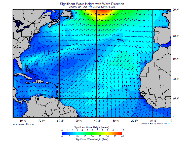


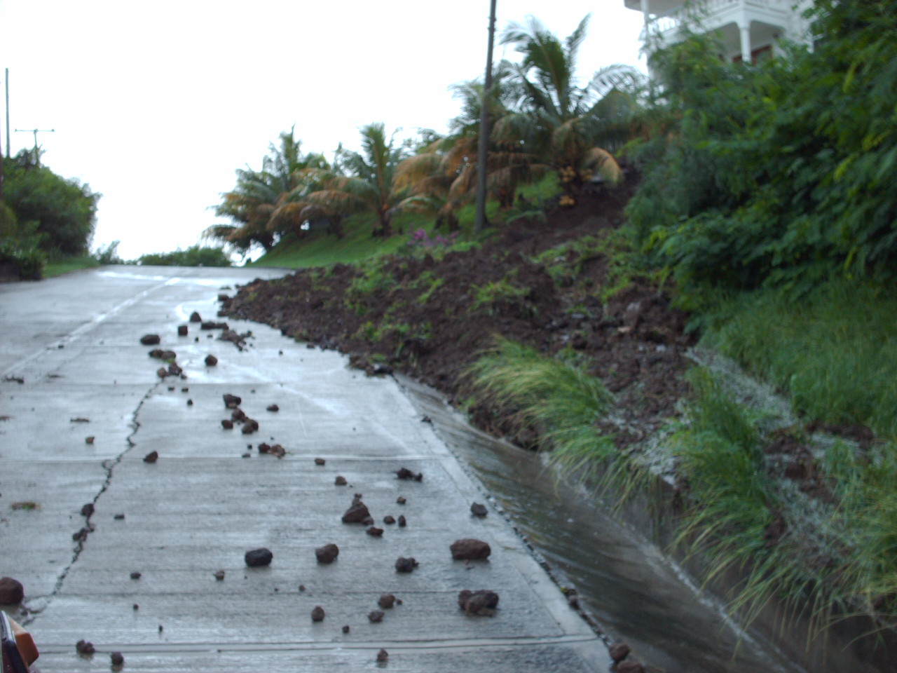
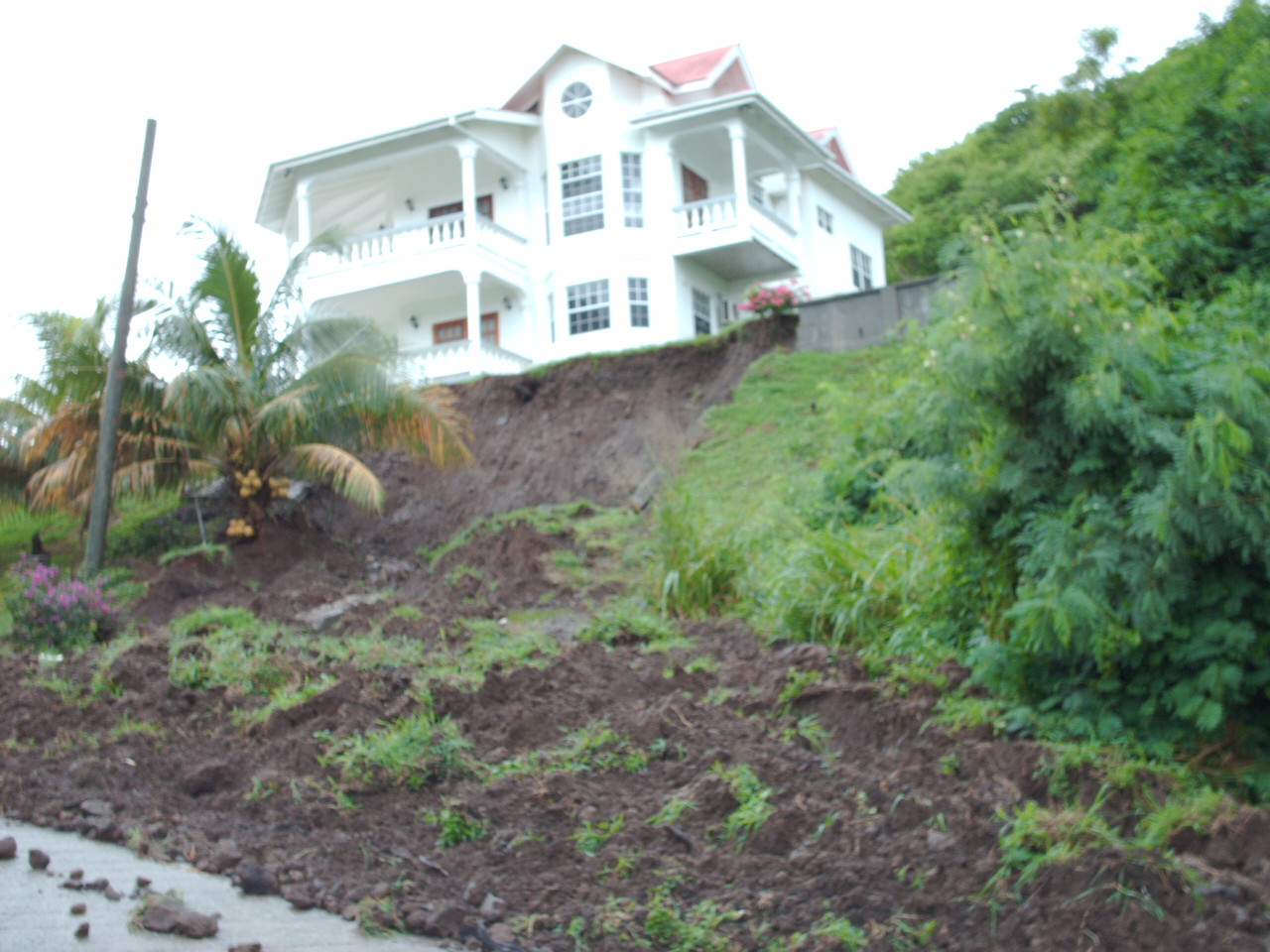
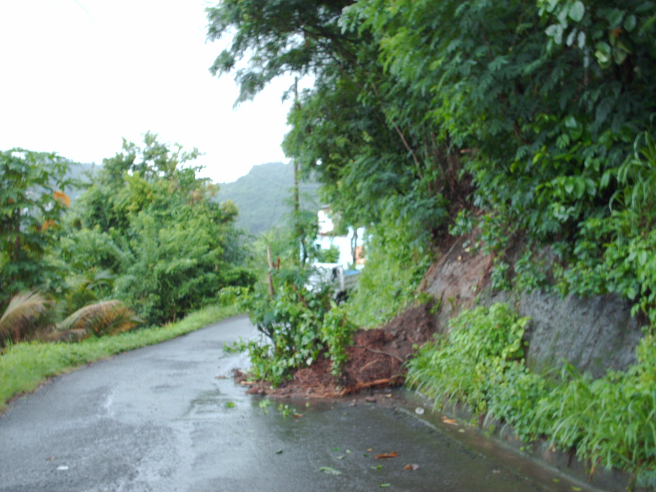
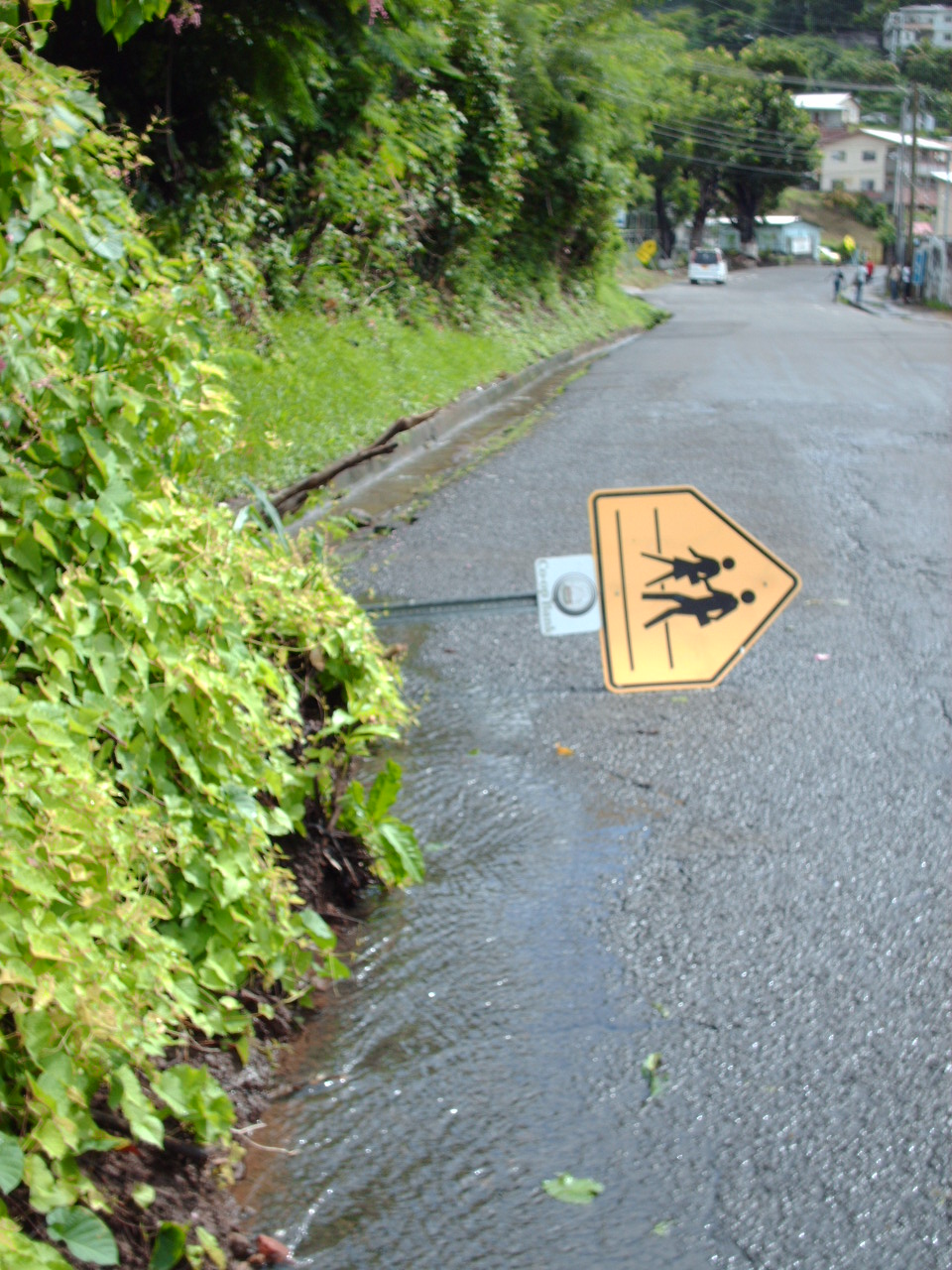
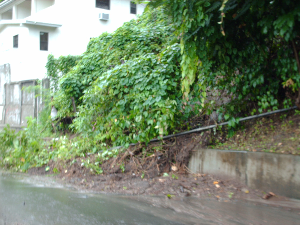
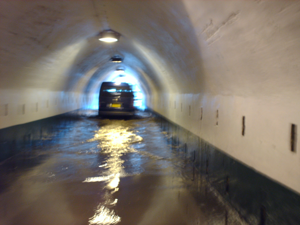
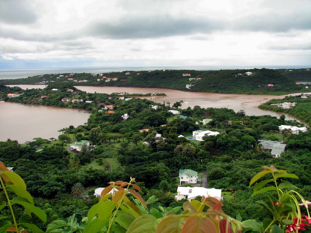
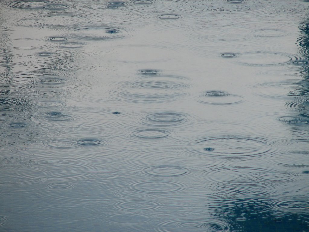
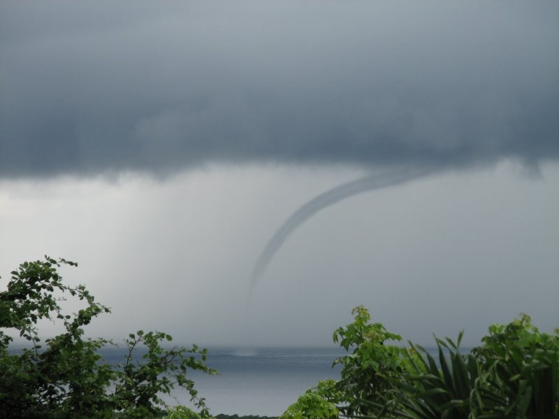