
|
- - - 2008 Hurricane Season - - -
|
- OMAR STATS
|
- From: "Steve Donahue" <steve at anguilla-weather.com>
- Date: Tue, 21 Oct 2008 14:41:27 -0400
|
STATS
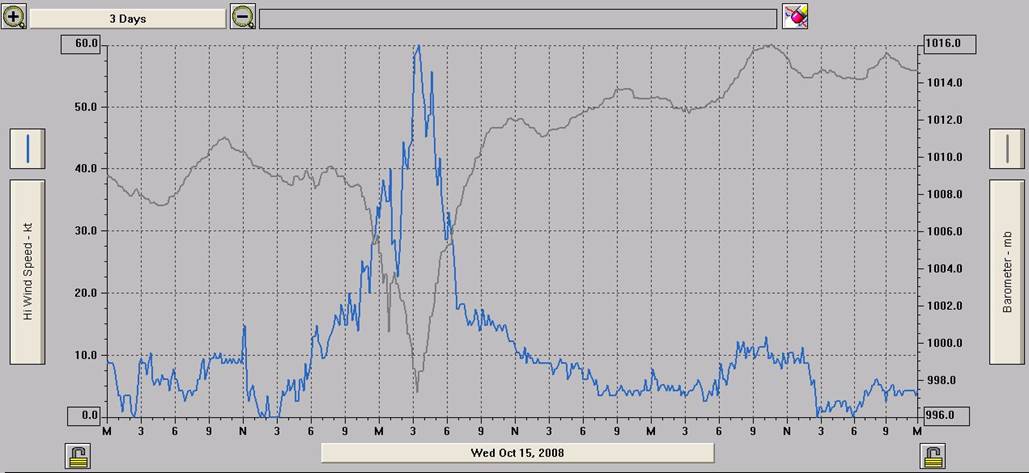
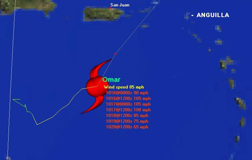
FOR HURRICANE OMAR – WEST END, ANGUILLA - Based
on the 11:00 PM Wednesday and 3:00 AM Thursday advisories, the eye passed 50.5
miles from my house here on the West End.
Peak gust of 60 knots (70 mph) occurred at 3:30 am from the SW (meaning the eye
was already slightly north of us), total rain for the entire event was 2.85 in.
with 1.53 in. falling during the passage, and low barometer reading was 997.3
mb (the eye was 959 mb – really low for this size storm). Some are
saying there were tornados on the island, but that is pretty unlikely - there
was very little thunder/lightening, satellite showed no high cloud tops,
and no damage reports that would indicate a tornado. Might have been a
few waterspouts.
Following is a graph of the high wind
gusts and barometer readings, as well as a graphic of the track going past us.
It was out of here pretty fast.
Let’s hope this season is over and
done!
Steve Donahue
Anguilla, AI2640, B.W.I.
US Phone – 410-505-8661
Anguilla Phone – 264-497-8177
Websites – www.anguilla-weather.com
& www.anguilla-diving.com
|
|
|
- Press release from Government of Anguilla
|
- From: "Steve Donahue" <steve at anguilla-weather.com>
- Date: Mon, 20 Oct 2008 11:22:36 -0400
|
Office of the Chief Minister, The Valley, Anguilla,
Friday, October 17, 2008
Anguilla's restoration efforts in the wake
of Hurricane Omar are proceeding
well and the country is on track for a full recovery
shortly. The passage
of the hurricane resulted in minor damage to the housing
stock of the
country and minimal impacts on the physical plant of the
tourism
infrastructure.
The brunt of the damage was mostly to coastal areas where
beaches, which did
not have large sand dunes, have been eroded due to heavy
wave action. Local
shipping assets at the Road Bay Harbour were beached as a result of the
storm surge, and efforts are now underway to have them
removed. A full
assessment of the damage is currently ongoing by the
National Disaster
Management Committee.
Government services have already been restored, the banking
sector is
operating at pre-hurricane capacity, telecommunications have
not been
interrupted, and the vital construction industry is resuming
its activity.
A number of large trees were uprooted due to the soft soil
that resulted
from many days of rains prior to the
hurricane. This condition coupled with
the high winds that traversed the island made the toppling
of large
vegetation a relatively easy feat for Hurricane Omar.
Private sector
equipment operators, volunteers and Government are jointly
cooperating in
clean up activities around the island.
The Government of Anguilla anticipates an uninterrupted
opening of the
tourist season in early November. In this regard we
encourage visitors who
have made reservation at hotel properties on Anguilla to make contact with
them.
We would like to thank God that no lives were lost and that
we have largely
been spared any major damage as a result of the passage of
Hurricane Omar.
To all who have sent best wishes to the people of Anguilla during this time
we thank you as well. I especially would like to
thank the National
Disaster Management Committee and the Anguilla Civil Service
who rose to the
occasion and made our country proud in an excellent response
to this event.
Osbourne B. Fleming
Chief Minster
Trudy Nixon
Executive Director
Anguilla Hotel and Tourism Association
Tel: 264 497 2944
Cell: 264 476 2944
Web: www.ahta.ai
Email: ahta at anguillanet.com
"Strengthening Anguilla's
Tourism Through Association"
The AHTA actively promotes the continuing improvement and
development of
Anguilla's Tourism Industry through the
exchange of information, training
activities, marketing and special interest programs.
Steve Donahue
Anguilla, AI2640, B.W.I.
US Phone – 410-505-8661
Anguilla Phone – 264-497-8177
Websites – www.anguilla-weather.com
& www.anguilla-diving.com
|
|
|
- ANGUILLA UPDATE
|
- From: "Steve Donahue" <steve at anguilla-weather.com>
- Date: Thu, 16 Oct 2008 19:24:06 -0400
|
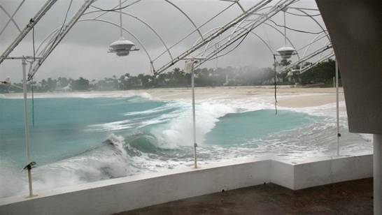
Just returned from a tour of the western part of the
island. No power island wide, but phones and internet from C & W seem
fine. American Eagle is supposed to arrive tonight – good.
Haven’t heard anything about ferries, but I would suspect tomorrow.
Schools closed. Except for the hotels and restaurants on the south facing
beaches, no serious damage to buildings. All of the boats that came
aground ant Sandy Ground did no damage to dwellings on the beach. Lots of
trees and many, many branches down everywhere, but saw now downed power poles
(but I hear a few are down)
As for the south side – serious damage to pretty much
all the hotels and restaurants. Sea washed right thru Altamer Restaurant
and the villas at Rendezvous Bay Hotel. Smokey’s at the Cove –
just a frame left. At Cap Juluca, all the beach from Georges west is gone
– waves breaking on the sea walls. Beach at Cuisineart is
gone. The sea came thru everywhere along the shore at Shoal Bay West,
Maundays Bay, Cove Bay and Rendezvous Bay – any low lying areas, the sea
just washed right thru. But already today, cleanup was in full
swing, and CJ, Cuisineart, Cove
Castles and Blue Waters
will be ready to open in a few weeks. The sea was already bringing in
sand.
Could have been a lot worse.
Steve Donahue
Anguilla, AI2640, B.W.I.
US Phone – 410-505-8661
Anguilla Phone – 264-497-8177
Websites – www.anguilla-weather.com
& www.anguilla-diving.com
|
|
|
- OMAR DAMAGE/PICTURES
|
- From: "Steve Donahue" <steve at anguilla-weather.com>
- Date: Thu, 16 Oct 2008 10:16:23 -0400
|
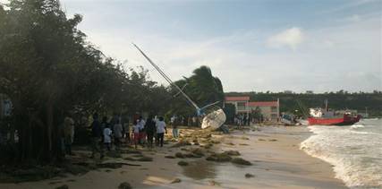
Did a quick tour this morning, and a lot of debris –
mostly tree branches – and a few large trees uprooted. Didn’t see
any poles down, but heard there are some in the east end. Lot
of wire flying around. As predicted, serious beach erosion on the south
beaches. There are about 8 boats beached at Sandy Ground along with mine.
Luckily, I could see no damage to my boat – even the sails were fine.
Just 2 snapped anchor line, and a 3rd anchor that dragged. Here’s
some quick pictures.
Stay safe – going to clean up the yard.
Steve Donahue
Anguilla, AI2640, B.W.I.
US Phone – 410-505-8661
Anguilla Phone – 264-497-8177
Websites – www.anguilla-weather.com
& www.anguilla-diving.com

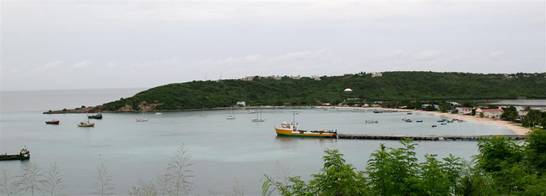
One of the 4 sailboats and other boats beached at Sandy
Ground

My boat. No damage, but it is high and dry!
Several other boats, including mine.
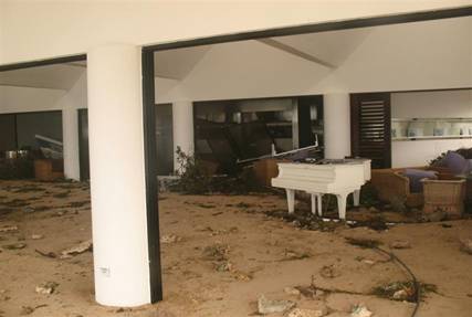
The interior of Altemar Restaurant, Shoal Bay West. See
went right through.
|
|
|
- WE MADE IT...
|
- From: "Steve Donahue" <steve at anguilla-weather.com>
- Date: Thu, 16 Oct 2008 07:28:08 -0400
|
… but it wasn’t fun. Power has been out since
about 1:30 AM (still out). Very little rain after midnight, but lottsa wind –
south, SW then west. Max gust – 60 knots – not too bad. Lots of
trees down in the yard, but no serious damage to the house. However, got a
call at 6:30 – my 34’ Hunter is on the beach at Sandy Ground. Must
have held all night but when the wind and swells came from the west (right into
Sandy Ground), that was it. Understand there are many boats on the beach,
including some cargo boats. At least I’m not on the rocks.
Just updated the website below, so you can see data from
last night. Going off gen power shortly.
Off to check the boat and see what’s happened on the
island. Later.
Cheers,
Steve Donahue
Anguilla, AI2640, B.W.I.
US Phone – 410-505-8661
Anguilla Phone – 264-497-8177
Websites – www.anguilla-weather.com
& www.anguilla-diving.com
|
|
|
- NOT LOOKING GOOD.
|
- From: "Steve Donahue" <tainos at anguillanet.com>
- Date: Wed, 15 Oct 2008 23:38:10 -0400
|
The 11:00 PM NWS advisory is now calling for a cat 3 storm
with winds of 115. Plus now it has gotten bigger – hurricane force
winds out to 35 miles (was 15 miles all day). And it gets worse –
closest point of approach is now only 46 miles (down from a CPA of 70 miles
earlier), passing to our west around 6:00 am. So we should figure on
winds very close to hurricane force – or at or above hurricane force.
And remember – we are to the EAST of the storm, so you have to add the
forward motion (currently 20 mph) to the forecast winds.
Is there any good news? Well, it’s moving fast,
so it won’t be around long – pretty much outta here late in the
morning.
Stay safe tonight – probably too late to do anything
about it now!
Steve Donahue
Anguilla, AI2640, B.W.I.
US Phone – 410-505-8661
Anguilla Phone – 264-497-8177
Websites – www.anguilla-weather.com
& www.anguilla-diving.com
|
|
|
- OMAR UPDATE
|
- From: "Steve Donahue" <tainos at anguillanet.com>
- Date: Wed, 15 Oct 2008 18:22:48 -0400
|
Omar has finally turned to the NE – good for Anguilla. Winds have increased some, but still a
small storm – hurricane winds out only 15 miles. Will come a little
closer to AXA than the last projected path (about 72 miles), but tropical force
winds extend only 115 miles.
I think the biggest concern continues to be rain and sea swells.
Rain has been light to moderate (0.80 in. all day), but think we’ll catch
the eastern edge of the “blob” on the satellite a little later.
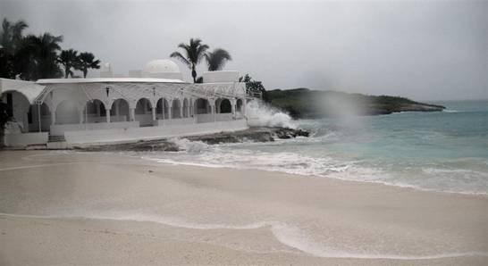
I just returned from a walk of Maundays
Bay (Cap Juluca Hotel –
south facing beach), and could not believe the size of the seas already –
and there is basically no wind. The seas are building quickly! Below
are a few pictures – waves already crashing in the restaurant and the
western end of the beach is pretty much covered. They should do fine
because of their sea wall – I’m concerned about some of the other
beaches.
Make sure to check the 11:00 NWS forecast for any changes,
but should pass to our west about 10:00 AM in the morning.
Cheers,
Steve Donahue
Anguilla, AI2640, B.W.I.
US Phone – 410-505-8661
Anguilla Phone – 264-497-8177
Websites – www.anguilla-weather.com
& www.anguilla-diving.com
|
|
|
- NOT MUCH CHANGE, BUT NEEDS TO HEAD NORTHEAST - QUICK!
|
- From: "Steve Donahue" <tainos at anguillanet.com>
- Date: Wed, 15 Oct 2008 14:51:48 -0400
|
Not much change as of 2:00 PM – forward speed has
increased to 13 mph – pretty fast. But as you can see below, it is
now heading more east than north – northeast. Not good for
us. Still projected to turn northeast, and be well to our west. But
it needs to turn quickly to spare us the worst.
The NWS forecast at 5:00 PM will tell us more about
it’s track and how close.
Steve Donahue
Anguilla, AI2640, B.W.I.
US Phone – 410-505-8661
Anguilla Phone – 264-497-8177
Websites – www.anguilla-weather.com
& www.anguilla-diving.com
|
|
|
- ALL PREPARED
|
- From: "Steve Donahue" <steve at anguilla-weather.com>
- Date: Wed, 15 Oct 2008 13:51:21 -0400
|
Picture below is Road
Bay, Anguilla – the cargo port
for Anguilla. There are normally about
50 – 60 pleasure boats in the harbor, but as you can see, it’s
pretty much emptied out. The cluster of boats at the far right center are
all waiting to be pulled out. I imagine the Lady Romney (yellow container
boat at dock) will be stuck here until Friday. Unfortunately, my sailboat
is right in the center along with a few others which can’t be hauled out
in Anguilla – no travel lift in Anguilla
for sailboats.
The ports are all closed as of 12:00 noon, and most
businesses and government have closed.
Cheers,
Steve Donahue
Anguilla, AI2640, B.W.I.
US Phone – 410-505-8661
Anguilla Phone – 264-497-8177
Websites – www.anguilla-weather.com
& www.anguilla-diving.com
|
|
|
- SOME GOOD NEWS!!!
|
- From: "Steve Donahue" <steve at anguilla-weather.com>
- Date: Wed, 15 Oct 2008 11:17:50 -0400
|
First of all, based on the 11:00 AM NWS forecast, Omar’s
track is moving further west. Closest point was 64 miles, now 80 miles (tropical
force winds extend out only 105 miles, so we’re close to the edge).
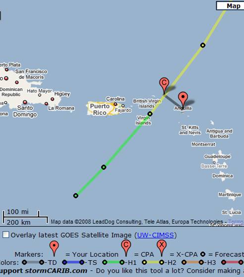
FORECAST POSITIONS AND MAX WINDS INITIAL 15/1500Z 15.2N 67.2W 75 KT 12HR VT 16/0000Z 16.6N 65.9W 80 KT 24HR VT 16/1200Z 19.1N 63.9W 90 KT...NRN LEEWARD ISLANDS (AXA is 18.2 N, 63.1W) 36HR VT 17/0000Z 22.0N 61.8W 90 KT 48HR VT 17/1200Z 24.7N 60.2W 85 KT 72HR VT 18/1200Z 30.0N 56.5W 75 KT 96HR VT 19/1200Z 37.0N 48.5W 65 KT 120HR VT 20/1200Z 45.0N 32.5W 55 KT...EXTRATROPICAL
Also, satellite shows some of the rain bands breaking up
before hitting Anguilla. Here on the West End, we’ve had no measurable rain since about
9:00 last night. In fact, the sun was trying to break thru about an hour ago.
But still plenty of rain to our SW.
Don’t let your guard down – as fast as the track
moved further west, it could just as fast move closer to us. Keep
watching the forecasts.
Cheers,
Steve Donahue
Anguilla, AI2640, B.W.I.
US Phone – 410-505-8661
Anguilla Phone – 264-497-8177
Websites – www.anguilla-weather.com
& www.anguilla-diving.com
|
|
|
- PRESS RELEASE FROM DISASTER MANAGEMENT
|
- From: "Steve Donahue" <steve at anguilla-weather.com>
- Date: Wed, 15 Oct 2008 08:02:01 -0400
|
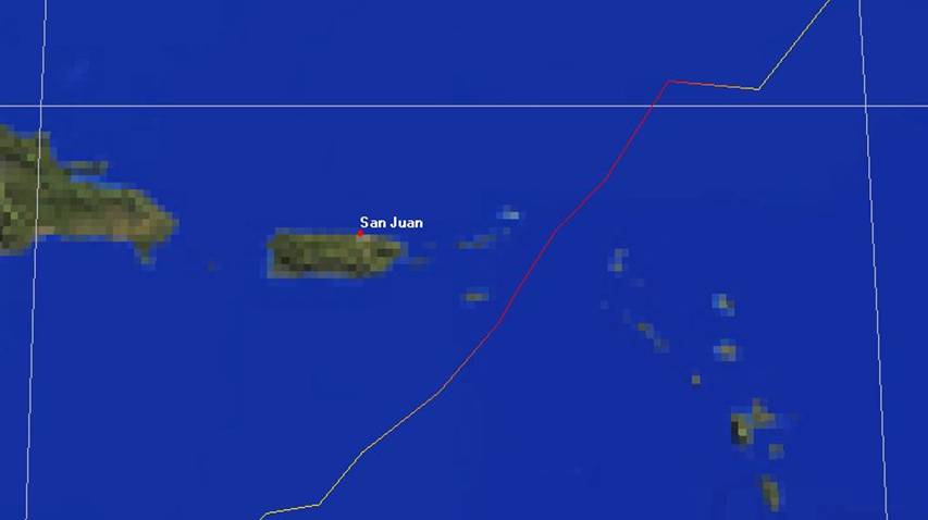
Also, just heard the American Eagle fly over to San Juan. Assume that this
will be the last plane out until at least Friday, but possibly Sat. morning.
Afternoon flights to/from SXM so far have not been cancelled.
PRESS RELEASE FROM THE
NATIONAL DISASTER MANAGEMENT COMMITTEE
Wednesday 15th, October 2008
Urgent Release No 2
The Department of Disaster Management is urging the public to rapidly
complete preparations to secure life and property as stated by the National
Hurricane Centre as Tropical Storm Omar draws closer to Anguilla and other Leeward Islands.
At a meeting last night of the
National Disaster Management
Committee the following decisions were taken:
That persons begin making
preparations:
To secure property and life;
To ensure that sufficient
supplies are in place for the passage of Omar; and
To secure valuables and ensure
that vital documents are protected.
Updated
Information,
Shelters will be opened later this
afternoon, with locations and a time to be announced via the media. Please
monitor this information.
The National Emergency Operations
Centre is being opened and will be staffed throughout the storm.
Persons wishing to leave the island
should monitor the ports for closure.
Persons living in low lying areas
such as Sandy Ground, the Valley Bottom, Welches and Mount Fortune,
should make arrangements with friends or family and evacuate to higher ground
as soon as possible.
Visitors to the island should consider
arrangements to leave Anguilla this morning.
Government workers are being asked
to report for duty at the usual time this morning in order to secure files,
computers and anything else related to their jobs and to complete this task by
10.00am.
Government offices will close at
approximately 10.00am to allow workers time to secure their own properties and
make other necessary arrangements.
All Government vehicles must be
located to protected areas. Information will be forthcoming to Department Heads
regarding locations.
The Chief Education Officer Mrs.
Rhonda Connor has announced that all government teachers are to report for duty
this morning to secure their classrooms, but there will be no school for the
students.
Local disaster management officials
are viewing the predicted path of Tropical Storm Omar with some urgency as the
forecast takes Omar near to, or over the northern Leewards tonight as a
possible Category 2 or stronger system.
Weather forecasters have predicted
up to 20 inches of rain from Tropical Storm Omar in low lying areas causing
flooding and possible mud slides.
REPEAT
The Department of Disaster Management is urging the public to rapidly
complete preparations to secure life and property.
Shelters will be opened later this
afternoon, with locations and a time to be announced via the media. Please
monitor this information.
The National Emergency Operations
Centre is being opened and will be staffed throughout the storm.
Persons wishing to leave the island
should monitor the ports for closure.
Persons living in low lying areas
such as Sandy Ground, the Valley Bottom, Welches and Mount Fortune,
should make arrangements with friends or family and evacuate to higher ground
as soon as possible.
Visitors to the island should consider
arrangements to leave Anguilla this morning.
Please continue to monitor the
storm and listen to local media for updated information.
If you require additional
information please call the Department of Disaster
Management at 497-2926, 476- 3622 or 476-3623.
Steve Donahue
Anguilla, AI2640, B.W.I.
US Phone – 410-505-8661
Anguilla Phone – 264-497-8177
Websites – www.anguilla-weather.com
& www.anguilla-diving.com
|
|
|
- HURRICANE OMAR A WET ONE
|
- From: "Steve Donahue" <steve at anguilla-weather.com>
- Date: Wed, 15 Oct 2008 06:53:19 -0400
|
Hurricane Omar is now forecast to be a cat 2 when it passes
about 64 miles to our west early Thursday morning (based on current info –
see graphic below). The good news is that it’s a very compact storm
with hurricane force winds (+74 mph) extending out only about 15 or 20 miles and
tropical force winds (39 – 74 mph) out 105 miles. The bad news is
that as of now, we will be in the right quadrant with the stronger wind (wind
speed + forward motion) and heavier rain. Expect rain anywhere from 4 –
10 in., and swells from the south or SW anywhere between 12 – 16 feet –
added to a storm surge of 2 feet. Expect some serious beach erosion on
south facing beaches, flooding in low areas. ASSUMING the track stays as
is, winds should be in 40 – 60 mph range, but higher gusts. But
assume the worst – this storm track will be going back and forth until it
gets here.
Rain has just started falling lightly (stopped during the
night), and it’s COLD – 76. Wind is 0. Dark clouds to
the south
As for me, patio furniture in the pool, hurricane shutters
are going up, and going to put a 3rd anchor out on the boat.
This one could be just some wind gusts and rain, or a direct hit with 100 mph +
winds. Assume the worst.
Latest hurricane advisory for Anguilla
attached. Good luck, all!
NOTE TO US
CITIZENS:
As US Embassy Wardens for Anguilla, we strongly recommend that if you have not
already done so, please make sure to register with the US Embassy in Barbados
at https://travelregistration.state.gov/ibrs/ui/
for contact in case of emergency. Please pass on to others.
Steve Donahue
Anguilla, AI2640, B.W.I.
US Phone – 410-505-8661
Anguilla Phone – 264-497-8177
Websites – www.anguilla-weather.com
& www.anguilla-diving.com
|
Attachment:
oledata.mso
Description: Binary data
Attachment:
HURRICANE OMAR _ Adv 12 (2).doc
Description: MS-Word document
|
|
- TS15 - WATCH OUT FOR THIS ONE
|
- From: "Steve Donahue" <steve at anguilla-weather.com>
- Date: Tue, 14 Oct 2008 17:29:01 -0400
|
As of 5:00 PM today, the projected path of Omar has moved
much further east (towards Anguilla), and is
projected to become a Cat 1 shortly – almost certain by the time it gets
here (Weather Service says 88% chance within 24 hours).
Latest track info has Omar as a Cat 1 passing 53 miles to
our east at 8:00 am Thursday. Big change since this AM.
Down south is getting all kinds of rain and it’s all
heading this way. South facing beaches will see lots of erosion from
swells and winds from the south Thursday and early Friday.
The attached advisory for Anguilla
shows the cone as of 2:00 PM. Below is the cone as of 5:00 PM – you
can see the westward movement. The NWS will be issuing an interim update at
8:00 PM, and a full update at 11:00 – view at http://www.nhc.noaa.gov/index.shtml?
Make sure to check the new forecasts.
![[Image of 3-day forecast, and coastal areas under a warning or a watch]](gifm8ujKkNr5d.gif)
Steve Donahue
Anguilla, AI2640, B.W.I.
US Phone – 410-505-8661
Anguilla Phone – 264-497-8177
Websites – www.anguilla-weather.com
& www.anguilla-diving.com
|
Attachment:
TS OMAR _ Adv 9.doc
Description: MS-Word document
|
|
- TD-15 - LOTSA RAIN
|
- From: "Steve Donahue" <steve at anguilla-weather.com>
- Date: Tue, 14 Oct 2008 09:11:04 -0400
|
Several models are predicting that TD-15 will track over
Puerto Rico and the Virgin Islands as a strong
tropical storm or a weak cat 1 hurricane. All models call for it to pass west
of AXA, but they always seem to have a problem modeling east moving storms –
so keep checking the forecast. No matter what, we’ll get plenty of
rain over the next several days – 4 to 8 in. predicted, with 12 in.
possible. Still calling for some 12 foot swells from the SW forming Wed.
night, but quickly calming by Fri. morning. While we are just on the edge
of the “3-day track forecast cone”, we are well within the cone for
tropical storm force winds (>= 39 mph). Based on the current satellite,
expect the skies to open this afternoon, and not see the sun until maybe Friday
– or later.
AXA Dept. of Disaster Management Advisory #6 attached.
Steve Donahue
Anguilla, AI2640, B.W.I.
US Phone – 410-505-8661
Anguilla Phone – 264-497-8177
Websites – www.anguilla-weather.com
& www.anguilla-diving.com
|
Attachment:
Tropical Storm Warning -Adv_6 (3).doc
Description: MS-Word document
|
|
- TROPICAL STORM WATCH FOR AXA
|
- From: "Steve Donahue" <steve at anguilla-weather.com>
- Date: Mon, 13 Oct 2008 19:03:08 -0400
|
First of all, correction to my last email – should have
read “…200 miles south of Dominican Republic – way to
our WEST” – not east.
Second, the Department of Disaster Management for Anguilla has issued Tropical Storm Watch effective 5:00
PM today - copy attached.
Steve Donahue
Anguilla, AI2640, B.W.I.
US Phone – 410-505-8661
Anguilla Phone – 264-497-8177
Websites – www.anguilla-weather.com
& www.anguilla-diving.com
|
Attachment:
Tropical Storm Watch -Adv_1 (2).doc
Description: MS-Word document
|
|
- TD15 - THE RETURN OF WRONG WAY LENNY???
|
- From: "Steve Donahue" <steve at anguilla-weather.com>
- Date: Mon, 13 Oct 2008 17:58:08 -0400
|
So TD 15 formed about 200 miles south of Dominican Republic
– way to our east. No problem, right??? Wrong! TD15 is/will
be moving north EAST and is forecast to pass about 100 miles to our north mid-day
on Thursday. Remember Lenny??? Forecasts call for it to become a
tropical storm (wind sheer is quite high, but will diminish in a day or so), and
will give us some gusty winds (could have 40 knot gusts) and a good chance of
very heavy rains starting Tuesday thru Thursday or Friday. Swells (maybe
as big as 12 – 14 foot range) will be coming out of the south late
Thursday/Friday.
It is important that you closely monitor this system over
the next several days, and be prepared for some heavy periods of rain.
Steve Donahue
Anguilla, AI2640, B.W.I.
US Phone – 410-505-8661
Anguilla Phone – 264-497-8177
Websites – www.anguilla-weather.com
& www.anguilla-diving.com
|
|
|
- ANGUILLA
|
- From: "Steve Donahue" <steve at anguilla-weather.com>
- Date: Tue, 9 Sep 2008 12:23:39 -0400
|
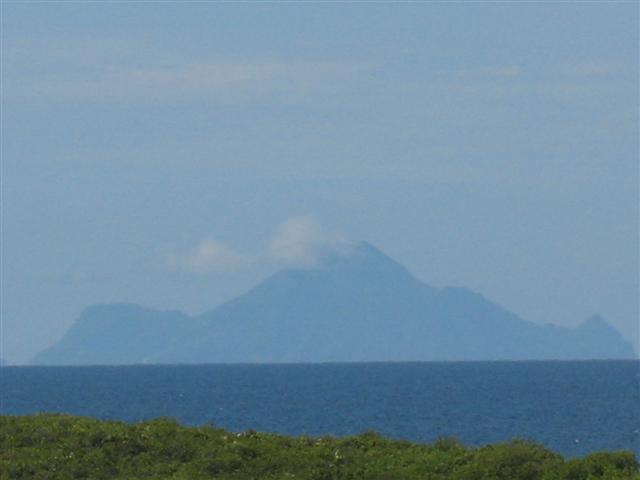
Beautiful day here in Anguilla - we can even se the houses in
Hell’s Gate and Windwardside in Saba, 37
miles away. See picture below.

Steve Donahue
Anguilla, AI2640, B.W.I.
US Phone – 410-505-8661
Anguilla Phone – 264-497-8177
Websites – www.anguilla-weather.com
& www.anguilla-diving.com
|
Attachment:
IMG_0008 (Small).JPG
Description: JPEG image
|
|
- TS IKE & TD10
|
- From: "Steve Donahue" <steve at anguilla-weather.com>
- Date: Tue, 2 Sep 2008 06:56:22 -0400
|
So far, no threat to AXA.
TS Ike is currently about 700 miles to our east at 18.6 N
(we are 18.1 N) and is expected to pass 225 miles to our north on Fri.
afternoon as a cat 1 hurricane. Expect a few showers with light winds coming
around from the west, but not much else.
TD 10 formed overnight 1,100 miles to our east near the Cape Verde Islands, but this one also should pass well
to the north of us sometime middle of next week.
There will be no further reports on these 2 storms unless
there is a change in direction towards AXA.
Steve Donahue
Anguilla, AI2640, B.W.I.
US Phone – 410-505-8661
Anguilla Phone – 264-497-8177
Websites – www.anguilla-weather.com
& www.anguilla-diving.com
|
|
|
- LOTS OUT THERE BUT NO THREAT TO AXA - YET
|
- From: "Steve Donahue" <steve at anguilla-weather.com>
- Date: Mon, 1 Sep 2008 13:06:29 -0400
|
TD#9 formed this morning about 1,500 miles east of AXA, but
all models show it going well to our north (it’s already at 17.6 N).
But we still need to keep an eye on this one as it formed quickly.
A strong wave just emerged from the west coast of Africa that could develop into a depression. Way to
early to know anything about this one, but early models show it going to our
north. Probably know more in 4 – 5 days.
An area of disturbed weather about 350 miles to our
southeast is not expected to develop, and looks like we won’t even get
any rain out of it.
Steve Donahue
Anguilla, AI2640, B.W.I.
US Phone – 410-505-8661
Anguilla Phone – 264-497-8177
Websites – www.anguilla-weather.com
& www.anguilla-diving.com
|
|
|
- CRAZY WEATHER
|
- From: "Steve Donahue" <steve at anguilla-weather.com>
- Date: Sun, 31 Aug 2008 13:19:47 -0400
|
We only get maybe 2 – 3 thunderstorms a year here in Anguilla. We have now had a thunderstorm each of the
last 5 days – including today. And significant rain for each of the last
5 days. Today started sunny and hot, but by noon, cloudy and rain. So far,
over 0.5 inches. My cistern loves it, but the tourists hate it. Cheers,
Steve Donahue
Anguilla, AI2640, B.W.I.
US Phone – 410-505-8661
Anguilla Phone – 264-497-8177
Websites – www.anguilla-weather.com
& www.anguilla-diving.com
|
|
|
- Very hot day
|
- From: kareemgumbs at digicel.blackberry.com
- Date: Wed, 20 Aug 2008 15:49:59 +0000
|
Sent from my BlackBerry® device from Digicel
|
|
- Rain rain rain and rain again
|
- From: kareemgumbs at digicel.blackberry.com
- Date: Thu, 14 Aug 2008 20:23:33 +0000
|
Yea its finally here!

Sent from my BlackBerry® device from Digicel
Attachment:
anguilla.jpg
Description: JPEG image
|
|
- SKIES HAVE OPENED UP!!!!
|
- From: "Steve Donahue" <steve at anguilla-weather.com>
- Date: Thu, 14 Aug 2008 17:06:09 -0400
|
Like St. Martin, viz is down to about 0.1 miles with lots of
thunder. We have had 0.7 in. in the past few minutes, and my Davis
Vantage Pro is telling me it’s coming down at a rate of over 2.2 inches
per hour. Impressive. I would not be surprised to see us lose power
shortly. Wind gusts have been less than 20 knots.
Steve
Donahue
Anguilla, BWI
US
Phone - (410) 505-8661
Anguilla Phone - (264) 497-8177
Websites - www.anguilla-weather.com & www.anguilla-diving.com
|
|
|
- NOT MUCH HAPPENING!
|
- From: "Steve Donahue" <steve at anguilla-weather.com>
- Date: Thu, 14 Aug 2008 12:48:45 -0400
|
BORING!!!!
While that big blob to our east seems to grow larger, nothing going on here –
and I mean nothing. We had a few quick showers this morning (about0.1 inches of
rain), what wind there is is from the south (like 5 knots or less), and it’s
really sticky. See current conditions at:
http://www.anguilla-weather.com/
I’m
hoping the skies will open up and give us some much needed rain. For months,
the Government of Anguilla has been unable to supply water to the east or west
end (50% of water produced is stolen, 20% lost to leaks), so we have to use
cistern water for plants, pool as well as home usage. For the first time in 16
years, I may have to buy water.
Steve
Donahue
Anguilla, BWI
US
Phone - (410) 505-8661
Anguilla Phone - (264) 497-8177
Websites - www.anguilla-weather.com & www.anguilla-diving.com
|
|
|
- STORM 92L CHANGES OVERNIGHT
|
- From: "Steve Donahue" <steve at anguilla-weather.com>
- Date: Thu, 14 Aug 2008 08:33:30 -0400
|
There
have been some changes with 92L overnight, and it will now pass just to our
north – closer than we thought. SHOULD remain a tropical wave for
today, but could become a depression later today/Friday. We can expect
rain, probably some thunder storms along with gusty winds. Latest report
show winds of 25 knots, but could easily increase some later today. We
will be on the south side of the storm which will lessen any impact.
No
reason to start putting up the hurricane shutters, but keep checking the
weather today.
Steve
Donahue
Anguilla, BWI
US
Phone - (410) 505-8661
Anguilla Phone - (264) 497-8177
Websites - www.anguilla-weather.com & www.anguilla-diving.com
|
|
|
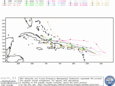
- Plots
|
- From: kareemgumbs at digicel.blackberry.com
- Date: Wed, 13 Aug 2008 16:39:18 +0000
|
Sent from my BlackBerry® device from Digicel Attachment:
storm_92.png
Description: Binary data
|
|
- Plots
|
- From: kareemgumbs at digicel.blackberry.com
- Date: Wed, 13 Aug 2008 16:33:44 +0000
|
For some reason I belive what those computer models have been dining this time
and in a way if it does pass close enough we all would be glad for the rain.
Cause we having being seeing any for a while. But for now skys or becoming
cloudy with little sprinkles now and then so who doesn't know will know will
now there's some around
Sent from my BlackBerry® device from Digicel
|
|
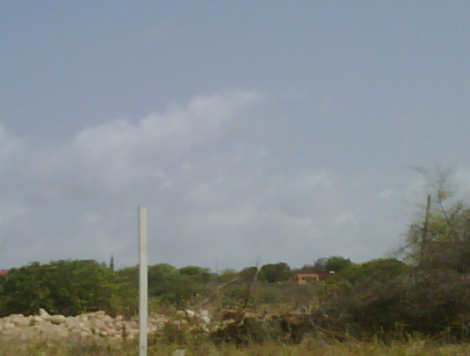
- Brilliant day in anguilla
|
- From: kareemgumbs at digicel.blackberry.com
- Date: Wed, 13 Aug 2008 14:42:17 +0000
|
Not much clouds, sun shining with all of its glory nice day for chilling with
the family on the beach hoping for the same 2 marrow.
Sent from my BlackBerry® device from Digicel
Attachment:
IMG00109.jpg
Description: JPEG image
|
|
- NO CURRENT THREATS!
|
- From: "Steve Donahue" <steve at anguilla-weather.com>
- Date: Wed, 13 Aug 2008 10:20:40 -0400
|
All
good news! Storm 92L (400 miles to our east) has not really developed and
will be passing well to our north. We can still hope for a little rain,
but even the chances of that are decreasing. Storm 93L in the far eastern
Atlantic may develop, but is tracking well to
our north and should be no threat. No further reports unless something
develops.
Steve
Donahue
Anguilla, BWI
US
Phone - (410) 505-8661
Anguilla Phone - (264) 497-8177
Websites - www.anguilla-weather.com & www.anguilla-diving.com
|
|
|
- STORM 92L HEADS NORTH
|
- From: "Steve Donahue" <steve at anguilla-weather.com>
- Date: Tue, 12 Aug 2008 07:51:59 -0400
|
92L
is located about 650 miles to our east, but models show it passing to our
north. The NHC has upgraded it to a more than 50% chance of developing, and a Hurricane
Hunter flight is scheduled for 2:00 PM today to investigate. Make sure to
check the status of this storm tonight after their flight.
93L
is still way out there, but is also looking like it will pass to our north.
Steve
Donahue
Anguilla, BWI
US
Phone - (410) 505-8661
Anguilla Phone - (264) 497-8177
Websites - www.anguilla-weather.com & www.anguilla-diving.com
|
|
|
- Perfect day today
|
- From: kareemgumbs at digicel.blackberry.com
- Date: Mon, 11 Aug 2008 19:28:44 +0000
|
Sent from my BlackBerry® device from Digicel Attachment:
IMG00106.jpg
Description: JPEG image
|
|
- Tropical Wave Invest 92 Forms
|
- From: "Steve Donahue" <steve at anguilla-weather.com>
- Date: Wed, 2 Jul 2008 11:00:44 -0400
|
Nothing much to worry about right
now, but strong Tropical Wave Invest 92 has formed over the far eastern Atlantic. There is the potential for this system to
develop over the next few days, but almost ALL model tracks show it moving well
north of the islands. But still need to keep an eye on it.
Click for details http://www.anguilla-weather.com/index.html.
Steve Donahue
Anguilla, BWI
US
Phone - (410) 505-8661
Anguilla Phone - (264) 497-8177
Websites - www.anguilla-weather.com & www.anguilla-diving.com
|
|
|
