- Updates from the Islands -

- - St.Croix (USVI) - -

| home | tools | pleas for help | QHWRN | guide | climatology | archive

- - - 2005 Hurricane Season - - -

- Linda Baxter Voted Best Lawyer in USVI.jpg
  • From: "Linda Baxter" <lawvi at attglobal.net>
  • Date: Tue, 28 Feb 2006 16:00:19 -0400
I am proud and excited to bring the news that The Virgin Island Daily News Readers Poll voted the Law Offices of Linda M. Baxter as the best Law Office in the United State Virgin Islands for 2006.   In addition,   I was voted Best Lawyer for St. Croix, St. Thomas and St. John.   I am very honored and touched that my office, staff and I have received such a prestigous award.
 
Linda M. Baxter
Law Offices of Linda M. Baxter
5041 Cotton Valley Shores
Christiansted,   VI  00820
(340) 773-9168
(340) 773-5941  Fax
lawvi at attglobal.net
 

Attachment: Linda Baxter Voted Best Lawyer in USVI.jpg
Description: Binary data


- Another beauuuuutiful day in Paradise ...
  • From: Heygirllll at aol.com
  • Date: Sat, 19 Nov 2005 09:02:23 EST
Yes, it's another beautiful day in Paradise; the ocean is flat calm, the most gorgeous shades of blue. The skies are clear, a few puffy clouds here and there. I LOVE it here!!!! I think today I'll skip work and hit the pool! Life is good.
 
Enjoy!
 
Jill in St. Croix

JPEG image


- Here we go again!
  • From: Heygirllll at aol.com
  • Date: Mon, 14 Nov 2005 06:09:03 EST
I thought we'd be sailing through November and ending the hurricane season with no more disturbances ... but alas, this is not the case! Last night and early this morning we had some gusty winds and heavy downpours; looks like there's more on the horizon, according to NOAA:
 

Hazardous Weather Outlook

HAZARDOUS WEATHER OUTLOOK
NATIONAL WEATHER SERVICE SAN JUAN PR
615 AM AST MON NOV 14 2005

VIZ001-002-AMZ710>730-151030-
615 AM AST MON NOV 14 2005

THIS HAZARDOUS WEATHER OUTLOOK IS FOR THE U.S. VIRGIN ISLANDS.

.DAY ONE...TODAY AND TONIGHT

THE COMBINATION OF HIGH PRESSURE CONTINUING TO BUILD NORTH OF PUERTO
RICO AND TROPICAL DEPRESSION NUMBER TWENTY SEVEN ABOUT 290 MILES
SOUTH SOUTHEAST OF ST CROIX WILL CONTINUE TO MAINTAIN STRONG WINDS
AND QUICKLY MOVING SHOWERS ACROSS THE LOCAL AREA.  SOME OF THE
STORMS WILL PRODUCE BRIEF PERIODS OF HEAVY RAINFALL WHICH WILL
PRODUCE LOCALIZED URBAN AND GUT TYPE FLOODING.

FOR THE MARINE CONDITIONS TODAY...THE SEAS WILL RANGE FROM 6 TO 8
FEET ACROSS COASTAL WATERS...WITH WINDS OF 17 TO 24 KNOTS WITH
HIGHER GUSTS IN THE QUICKLY MOVING SHOWERS. THE WINDS WILL HELP
PRODUCE DANGEROUS AND CHOPPY SEAS. A SMALL CRAFT ADVISORY IS IN
EFFECT FOR ALL THE LOCAL WATERS EXCEPT THE NEAR SHORE WATERS OFF
WESTERN PUERTO RICO.

.DAYS TWO THROUGH SEVEN...

TROPICAL DEPRESSION NUMBER TWENTY SEVEN IS FORECAST TO BE ABOUT 200
MILES SOUTHWEST OF ST CROIX EARLY TUESDAY MORNING...WITH INCREASING
CHANCES OF NUMEROUS SHOWERS...SCATTERED THUNDERSTORMS AND CONTINUING
STRONG WINDS. HEAVY RAINFALL IS POSSIBLE WHICH COULD PRODUCE
LOCALIZED FLASH FLOODING.

.SPOTTER CALL TO ACTION STATEMENT...

SPOTTER ACTIVATION IS ANTICIPATED.

$$

STAY TUNED TO NOAA WEATHER RADIO AND OTHER LOCAL MEDIA FOR FURTHER
DETAILS OR UPDATES.

FOR ADDITIONAL INFORMATION...VISIT THE NATIONAL WEATHER SERVICE WEB
SITE FOR PUERTO RICO AND THE U.S. VIRGIN ISLANDS AT (ALL LOWERCASE
LETTERS): HTTP://WWW.SRH.NOAA.GOV/SJU.

$$


Wind Advisory

URGENT - WEATHER MESSAGE...UPDATED
NATIONAL WEATHER SERVICE SAN JUAN PR
1039 PM AST SUN NOV 13 2005

PRZ001>013-VIZ001-002-141400-
/O.CON.TJSJ.WI.Y.0004.000000T0000Z-051114T1400Z/
SAN JUAN AND VICINITY-NORTHEAST-SOUTHEAST-EASTERN INTERIOR-
NORTH CENTRAL-CENTRAL INTERIOR-PONCE AND VICINITY-NORTHWEST-
WESTERN INTERIOR-MAYAGUEZ AND VICINITY-SOUTHWEST-CULEBRA-VIEQUES-
ST. THOMAS ST. JOHN AND ADJACENT ISLANDS-ST CROIX-
1039 PM AST SUN NOV 13 2005

...WIND ADVISORY REMAINS IN EFFECT UNTIL 10 AM AST MONDAY...

A WIND ADVISORY REMAINS IN EFFECT UNTIL 10 AM AST MONDAY FOR ALL
OF PUERTO RICO...INCLUDING CULEBRA AND VIEQUES...AND FOR ALL OF
THE U.S. VIRGIN ISLANDS...ESPECIALLY FOR ELEVATIONS OF 300 FEET
AND ABOVE.

SUSTAINED NORTHEAST WINDS OF 25 TO 35 MPH WITH LOCAL GUSTS TO 40
TO 45 MPH...WILL CONTINUE TO AFFECT THE LOCAL ISLANDS THROUGH AT
LEAST 10 AM MONDAY...ESPECIALLY ACROSS THE HIGHER ELEVATIONS. THE
STRONGEST GUSTS WILL LIKELY OCCUR IN THE VICINITY OF PASSING
SHOWERS AND THUNDERSTORMS AND IN THE MOST EXPOSED AREAS TO THE
NORTHEAST.

A WIND ADVISORY MEANS THAT SUSTAINED WIND SPEEDS OF 25 MPH OR
GREATER ARE EXPECTED ACROSS THE ADVISORY AREA. PEOPLE IN THE
ADVISORY AREA SHOULD SECURE ANY LOOSE OUTDOOR ITEMS SUCH AS
GARBAGE CANS OR LAWN FURNITURE. TRUCKS AND HIGH PROFILE VEHICLES
SHOULD BE PREPARED FOR STRONG GUSTY WINDS...ESPECIALLY ACROSS
HIGHER TERRAIN AND MOUNTAIN PASSES.

$$

BCS/ASL
***********************************************************
BUT ... winter weather is right around the corner ... sunshine, blue skies, gentle breezes ... paradise!
Enjoy!
Jill in St. Croix
 

- No news is good news!
  • From: Heygirllll at aol.com
  • Date: Tue, 1 Nov 2005 19:12:03 EST
No reports from here in the past few days, and that means all is well! We've gotten back to the good ol' tropical weather, warm sunshine and the kind of days that just make you want to say "Let's skip work and go to the beach"  ... maybe next week!
 
Last Sunday I spent a couple of hours snoozin' in the pool and caught some most excellent rays ... love that! We're still watchin' the weather but also enjoying the sunshine. The punkin turned orange and the orchids are still bloomin' ... life is gooooooooooood!
 
Nothin' on the immediate horizon, so we'll just keep enjoying the fabulous weather and think about getting ready for the holidays! Oh boy, Thanksgiving is right around the corner ... let's throw a turkey in the oven and go divin'! GOOD TIMES!
 
Enjoy!
 
Jill in St. Croix

JPEG image

JPEG image


- We're getting heavy rain ...
  • From: Heygirllll at aol.com
  • Date: Sat, 22 Oct 2005 21:14:41 EDT
It has suddenly started to rain very, very hard. I checked the hazardous weather site, and here's the reason:
 

Flood Statement

VIC010-230330-

URGENT - IMMEDIATE BROADCAST REQUESTED
FLOOD STATEMENT
NATIONAL WEATHER SERVICE SAN JUAN PR
841 PM AST SAT OCT 22 2005

AN URBAN AND SMALL STREAM FLOOD ADVISORY HAS BEEN ISSUED BY THE
NATIONAL WEATHER SERVICE IN SAN JUAN EFFECTIVE UNTIL 11:30 PM AST
SATURDAY EVENING FOR PEOPLE IN THE FOLLOWING ISLAND

IN THE U.S. VIRGIN ISLANDS
ST CROIX

AT 8:35 PM AST...NWS DOPPLER RADAR INDICATED BANDS OF HEAVY SHOWERS
AND THUNDERSTORMS MOVING NORTH NORTHWESTWARD ACROSS ST CROIX...
PRODUCING PERIODS OF HEAVY RAIN. ADDITIONAL BANDS OF THUNDERSTORMS
ARE LINED UP SOUTH TO NORTH ACROSS THE LOCAL CARIBBEAN WATERS AND
WILL MOVE NORTHWARD ACROSS ST CROIX IN THE NEXT HOUR...AND LEAVE
RAIN ACCUMULATIONS OF ONE TO TWO INCHES ACROSS MUCH OF THE ISLAND.

EXCESSIVE RUNOFF FROM THESE SHOWERS AND THUNDERSTORMS WILL CAUSE
FLOODING OF GUTS AND STREAMS...HIGHWAYS AND ROADWAYS.
ADDITIONALLY...ROADS AND LAND ALONG THE BANKS OF CREEKS AND STREAMS
AND OTHER LOW LYING AREAS ARE SUBJECT TO FLOODING. ALSO...MUDSLIDES
ARE POSSIBLE IN AREAS OF STEEP TERRAIN.

$$

70

- Very windy today ...
  • From: "Chandler" <cruzans at attglobal.net>
  • Date: Fri, 21 Oct 2005 17:30:27 -0400
It's been very windy and gray today, but with intermittent rain.  I am enclosing a weather station report on St. Croix, where you can see the latest observations.  The satellite shows a large blob south of us, and the predictions call for a strengthening of this system.  Let's pay close attention!


Click On Image To Enlarge
 
Guy

- URGENT - WEATHER MESSAGE: Wind Advisory for USVI and PR ...
  • From: Heygirllll at aol.com
  • Date: Fri, 21 Oct 2005 17:01:29 EDT
Here's a copy of the latest "Hazardous Weather Outlook" from the NOAA weather site. Looks like we're gonna have some wind and rain this weekend. Judging from the updates from the people in St. Lucia, I'll be curious to see how windy it gets here.  
I saw a blurb on the weather channel this morning, before they talked about Wilma, regarding the Virgin Islands being attentive to what's approaching.  
Stay safe and my thoughts are with the people facing Wilma.
 

Wind Advisory

URGENT - WEATHER MESSAGE
NATIONAL WEATHER SERVICE SAN JUAN PR
309 PM AST FRI OCT 21 2005

...STRONG AND GUSTY WINDS ACROSS THE U.S. VIRGIN ISLANDS...VIEQUES
AND CULEBRA|...

PRZ012-013-VIZ001-002-220315-
/X.NEW.TJSJ.WI.Y.0003.051021T1909Z-051022T1000Z/
CULEBRA-VIEQUES-ST. THOMAS ST. JOHN AND ADJACENT ISLANDS-ST CROIX-
309 PM AST FRI OCT 21 2005

...WIND ADVISORY IN EFFECT UNTIL 6 AM AST SATURDAY...

THE NATIONAL WEATHER SERVICE IN SAN JUAN HAS ISSUED A WIND
ADVISORY...WHICH IS IN EFFECT UNTIL 6 AM AST SATURDAY.

WINDS OF 25 TO 35 MPH ARE EXPECTED ESPECIALLY ACROSS THE HIGHER
ELEVATIONS OF THE U.S VIRGIN ISLANDS...VIEQUES AND CULEBRA.

A WIND ADVISORY MEANS THAT SUSTAINED WIND SPEEDS OF 25 MPH OR
GREATER ARE POSSIBLE ACROSS THE ADVISORY AREA. PEOPLE IN THE
ADVISORY AREA SHOULD SECURE ANY LOOSE OUTDOOR ITEMS SUCH AS
GARBAGE CANS OR LAWN FURNITURE. TRUCKS AND HIGH PROFILE VEHICLES
SHOULD BE PREPARED FOR STRONG GUSTY WINDS...ESPECIALLY ACROSS
HIGHER TERRAIN.

$$

RM


- More rain is on the way ...
  • From: Heygirllll at aol.com
  • Date: Fri, 21 Oct 2005 07:08:30 EDT
Looks like we'll have another wet weekend; I was really hoping to get some quality pool-time this weekend. It's currently not raining, but I see the clouds approaching. Here's the hazardous weather outlook for the US Virgin Islands, 2 tropical waves are on the way ...

Hazardous Weather Outlook

HAZARDOUS WEATHER OUTLOOK
NATIONAL WEATHER SERVICE SAN JUAN PR
630 AM AST FRI OCT 21 2005

VIZ001-002-AMZ710>730-221030-
630 AM AST FRI OCT 21 2005

THIS HAZARDOUS WEATHER OUTLOOK IS FOR THE U.S. VIRGIN ISLANDS.

.DAY ONE...TODAY AND TONIGHT

MORE FREQUENT SHOWERS ARE EXPECTED OVER THE NEXT COUPLE OF DAYS AS
TWO TROPICAL WAVES ARE FORECAST TO AFFECT THE AREA. THE FIRST
TROPICAL WAVE IS CURRENTLY OVER THE MONA PASSAGE. AN INCREASE IN LOW
LEVEL MOISTURE BEHIND THIS WAVE WILL BRING AN INCREASE IN AFTERNOON
SHOWER AND THUNDERSTORM ACTIVITY TODAY AND TONIGHT.


.DAYS TWO THROUGH SEVEN...

ANOTHER TROPICAL WAVE...JUST EAST OF THE WINDWARD ISLANDS...IS
ACCOMPANIED BY ABUNDANT TROPICAL MOISTURE AND A SIGNIFICANT AREA OF
SHOWERS AND THUNDERSTORMS. THIS TROPICAL WAVE WILL PASS ACROSS THE
LOCAL AREA SATURDAY TO FURTHER INCREASE SHOWER AND THUNDERSTORM
ACTIVITY.


.SPOTTER CALL TO ACTION STATEMENT...

SPOTTER ACTIVATION MAY BE NECESSARY.

$$

STAY TUNED TO NOAA WEATHER RADIO AND OTHER LOCAL MEDIA FOR FURTHER
DETAILS OR UPDATES.

FOR ADDITIONAL INFORMATION...VISIT THE NATIONAL WEATHER SERVICE WEB
SITE FOR PUERTO RICO AND THE U.S. VIRGIN ISLANDS AT (ALL LOWERCASE
LETTERS): HTTP://WWW.SRH.NOAA.GOV/SJU.


- It's raining ... a LOT ...
  • From: Heygirllll at aol.com
  • Date: Mon, 10 Oct 2005 09:37:52 EDT
Holy cow ... it's raining cats & dogs! This morning we woke up to thunder and lightning ... not too much, but there were a couple of good boomers; enough to send both dogs into the closet.
It's now about 9:30 and raining very hard and a pretty good wind is accompanying that - our wind chimes are really chimin' again - I LOVE that sound.
The satellite pictures show a big cloud, and it looks like it'll be here for a while. NOAA has a Hazardous Weather Outlook posted here:
Click here: Weather Hazards for Christiansted, VI  which includes flash flood warnings in effect for the Virgin Islands and Puerto Rico.
 
I dropped my brother off at work this morning and found there is quite a bit of standing water here and there. Please be careful if you're out and about.
 
What a great day for being indoors, I think I'll clean up the computer room and putter around the house. Happy Columbus Day!
 
Jill in St. Croix

JPEG image


- It's here ...
  • From: Heygirllll at aol.com
  • Date: Sat, 8 Oct 2005 21:26:45 EDT
The storm is upon us, and it is raining HARD! This is the loudest I've ever heard the rain on our tin roof. Even Frank the cat came running for cover, meowing like he'd been struck by lightning! I've never seen him freaked out like he was tonight ... I think it's gonna be a whopper.
 
It's about 9:30 p.m. and we're having thunder and lightning and amazing amounts of rain. The lights are now flickering ... I better send this and get my flashlight ready.
 
Jill in St. Croix

- YOWZA ...
  • From: Heygirllll at aol.com
  • Date: Sat, 8 Oct 2005 15:28:42 EDT
Looks like we're in for some rain and thunder and lightning ... woooohoooooo!
 
Thanks to MJ at the Culebra (PR) site for the heads-up on the weather warning ... it sounds like a doozie! I've copied it from the NOAA weather site and pasted it below.
 
I love the storms, but our poor dogs will be rearranging the closet again, no doubt about that. I will try to get a picture of a lightning bolt, or maybe a waterspout ... that would be exciting to see.
 
The Hazardous Weather Outlook below refers to "AN EXPLOSIVELY UNSTABLE ATMOSPHERE" ... ? interesting, isn't it? Sounds kinda scary to me, I better make sure my camera batteries are charged and ready to go! I'll keep you posted.
 
Jill in St. Croix
 
from NOAA weather:
 

Hazardous Weather Outlook

HAZARDOUS WEATHER OUTLOOK
NATIONAL WEATHER SERVICE SAN JUAN PR
630 AM AST SAT OCT 8 2005

VIZ001-002-AMZ710>730-091030-
630 AM AST SAT OCT 8 2005

THIS HAZARDOUS WEATHER OUTLOOK IS FOR THE U.S. VIRGIN ISLANDS.

.DAY ONE...TODAY AND TONIGHT

A LARGE AND ENERGETIC UPPER LEVEL LOW ACROSS THE ATLANTIC WELL TO
OUR NORTHEAST THIS MORNING HAS ALREADY BEGUN TO CREATE UNSTABLE
ATMOSPHERIC CONDITIONS ACROSS THE REGION THIS MORNING...AND WILL
MOVE WEST INTO A MORE FAVORABLE POSITIONS TO GENERATE STRONG
THUNDERSTORM ACTIVITY AND VERY HEAVY RAIN IN THE NEXT FEW DAYS. A
MOISTENING SOUTHEAST LOW LEVEL FLOW TODAY IS EXPECTED TO BRING
SCATTERED SHOWERS AND THUNDERSTORMS FROM THE LOCAL CARIBBEAN
NORTHWARD INTO THE LOCAL ISLANDS TODAY...WITH THUNDERSTORM ACTIVITY
THEN SHIFTING NORTH AND NORTHEAST THIS AFTERNOON THROUGH TONIGHT.
SOME AREAS WILL SEE HEAVY RAINFALL POSSIBLY LEADING TO URBAN AND GUT
FLOODING. INTENSE THUNDERSTORMS WILL ALSO PRODUCE STRONG GUSTY
WINDS...DANGEROUS CLOUD TO GROUND LIGHTNING...AND POSSIBLE
WATERSPOUTS.

MODERATE NORTHEAST SWELLS CONTINUE TO MOVE INTO THE REGIONAL WATERS
AND ARE MAINTAINING SEAS AROUND 6 FEET ACROSS THE OFF SHORE
ATLANTIC. SOME OF THIS SWELL ENERGY IS MAKING IT INTO THE NORTH AND
NORTHEAST COASTS AND BEACHES OF THE LOCAL ISLANDS...GENERATING RIP
CURRENTS.

.DAYS TWO THROUGH SEVEN...

THE UPPER LEVEL LOW WILL MOVE INTO A MORE FAVORABLE POSITION SUNDAY
THROUGH MONDAY TO CREATE AN EXPLOSIVELY UNSTABLE ATMOSPHERE. AT THE
SAME TIME...TROPICAL MOISTURE WILL BE INCREASING IN BOTH DEPTH AND
QUANTITY ACROSS THE LOCAL AREA...AND VERY HEAVY...AND POSSIBLY
EXTREME RAINFALL MAY BE SEEN. THE POTENTIAL FOR INTENSE OR SEVERE
THUNDERSTORMS WILL ALSO PREVAIL SUNDAY AND MONDAY. THE UPPER LOW IS
EXPECTED TO MOVE NORTHWESTWARD AND GRADUALLY EXIT THE REGION TUESDAY
AND WEDNESDAY...BUT WITH HIGH RAINFALL CHANCES PERSISTING.

THERE IS THE POTENTIAL FOR A TROPICAL OR SUBTROPICAL CYCLONE TO
DEVELOP ACROSS THE OFF SHORE ATLANTIC TO THE NORTH OR NORTHWEST OR
OUR AREA SUNDAY THROUGH TUESDAY...AND COULD INDIRECTLY INCREASE THE
LOCAL WIND FLOW ACROSS OUR AREA...AND EVENTUALLY GENERATE MODERATE
TO LARGE SWELLS THAT WOULD AFFECT THE LOCAL WATERS LATER IN THE
WEEK.

.SPOTTER CALL TO ACTION STATEMENT...

SPOTTER ACTIVATION IS REQUESTED.

$$

STAY TUNED TO NOAA WEATHER RADIO AND OTHER LOCAL MEDIA FOR FURTHER
DETAILS OR UPDATES.

FOR ADDITIONAL INFORMATION...VISIT THE NATIONAL WEATHER SERVICE WEB
SITE FOR PUERTO RICO AND THE U.S. VIRGIN ISLANDS AT (ALL LOWERCASE
LETTERS): HTTP://WWW.SRH.NOAA.GOV/SJU.


- BIG lightning & HUGE thunder ...
  • From: Heygirllll at aol.com
  • Date: Mon, 3 Oct 2005 06:42:54 EDT
It was a dark and stormy Sunday ... perfect day for being indoors and catching up on chores. I watched the storm from the front porch, while transplanting the basil into bigger pots and getting it ready to become pesto ... YUM. We had thunder and lightning throughout most of the afternoon and through the evening.
 
The power went out around 9:30ish p.m. and then the storm really became active. HUGE bolts of lightning, with thunder not far behind. Fortunately, the power was restored shortly after 10, so we could turn up the volume on the TV to help drown out some of the loud thunder. Our poor puppies hate thunder storms, they both took cover in the closet. Even Mr. Stinkers, our indoor cat, was a little freaked and stayed on the bed most of the night.
 
It's now morning and it's still raining - it rained A BUNCH last night. The pool is filled to the top! The outdoor cats have taken refuge on the back porch and are looking pretty comfy lounging in 'their' patio chairs. The local forecast on the weather channel shows a huge green blob over us - I think it's gonna be another dark and stormy day. That's ok ... the orchids and our first crop of bananas LOVE the water ... it's gonna be a good day.
 
Enjoy!
 
Jill in St. Croix

JPEG image

JPEG image


- Here we go ...
  • From: Heygirllll at aol.com
  • Date: Sun, 18 Sep 2005 10:14:57 EDT
It's another lovely day here in paradise. The sunrise yesterday was beauuuuuuuuuuuuuuuuutiful. Here's a picture taken from the Leisure Lady on our way out to catch some fish during the 6th Annual Guy/Gal Reel Challenge. Here comes the sun ... doot-n-doodoo (think Beatles). I didn't catch any keepers, but caught lots of rays and have the sunburn to prove it. Owie ... shoulda slapped on more sunscreen.
 
It's been extremely warm the past several weeks. I thought perhaps I was just being a wimp, but even the locals who've lived here forever say it's been exceedingly hot. We've also had a big bunch of Sahara Dust, which is ok because it helps keep the hurricanes away and makes for some spectacular sunsets. Below is a picture taken earlier this month from our front porch. I LOVE it here!
 
We've got our eye on Philippe, which is currently a tropical storm, and is expected to go north and miss us. And more weather stuff coming off of Africa, we'll be watching and keep you posted.
 
Time to hit the pool ...
 
Enjoy!
 
Jill in St. Croix

JPEG image

JPEG image


- Counting my blessings ...
  • From: Heygirllll at aol.com
  • Date: Mon, 5 Sep 2005 20:23:30 EDT
 
My thoughts and prayers are with the victims of Hurricane Katrina. I continue to watch the news and cannot believe this is happening in America - how can this be possible? I am stunned by the devastation and cannot imagine being left with nothing but the clothes on my back; although some have lost much more than that. It's truly heartbreaking to see this.
 
Last week I went back to Oregon for my high school reunion. On the way back, from Dallas to Miami, we flew over Louisiana and I saw some of the flooding - what an awful sight. It just seems so very surreal, doesn't it?
 
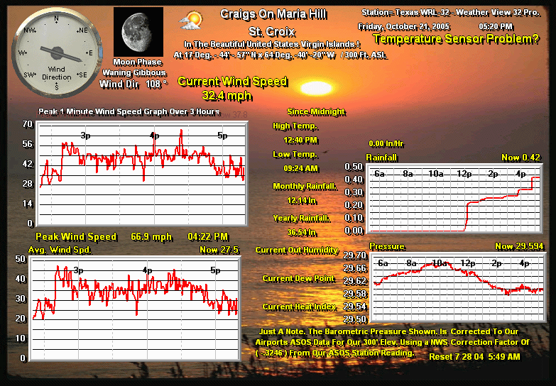
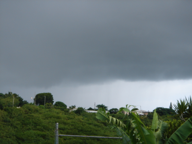
It's been quite warm here for the past few days, with very little wind. 
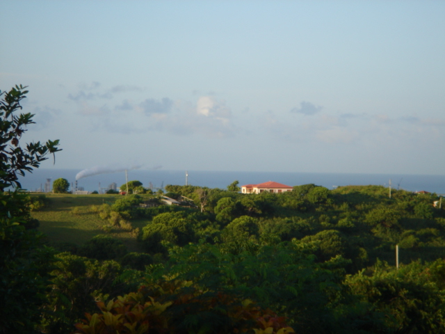
Today was the first day in quite a while we had a dust-free view of the ocean. In fact, we went scuba diving over at Cane Bay, and coming over the hill to the north side of our island we could see all the islands across the away. It was a spectacular sight and a great dive.  
 
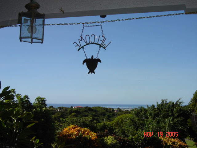
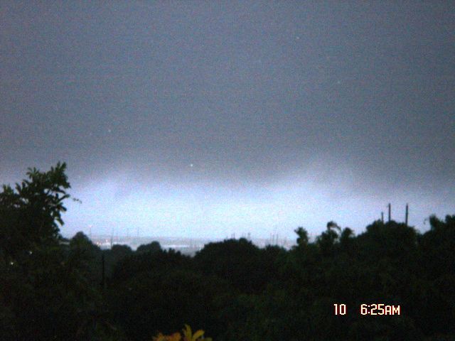
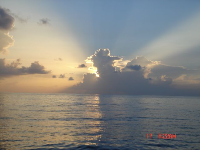
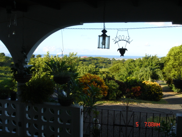
The morning view from our front doorstep was beautiful and the 
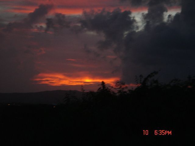
sunset tonight gorgeous ... I am counting my blessings.
 
 
Jill in St. Croix

JPEG image

JPEG image


- Make an Islander Think
  • From: "Aaron McLees" <amclees1 at excite.com>
  • Date: Wed, 31 Aug 2005 16:37:47 -0400 (EDT)
If what has happened in the gulf coast doesn't make you prepare for the worst hurricane ever experienced in the Virgin Islands. Well then..... I'M not going to be feeling sorry for the people here when it happens. I'M prepared. I will don't have to loot. If people try to loot my house the will be worm food. I have everything that I kneed, and there is not even a hurricane on the horizon. Time to prepare people. No BS here WE are going to get one soon. Set yourself straight. TIME TO PREPARE. Don't let yourself be like the poor soles in NOLA who thought that it was just another warning that would go by without incident. Read the posts an NOLA.com If you need some more encouragement.


Join Excite! - http://www.excite.com
The most personalized portal on the Web!

- Are we having a hurricane???????
  • From: Heygirllll at aol.com
  • Date: Wed, 24 Aug 2005 07:32:44 EDT
No we're not, but HOLY COW ... it sure is windy and stormy! I woke up at 4:45 for my first push of the snooze button and heard the garage door rattling and the wind chimes chimin' and I just had to get up and see what was going on outside. We've got lots of clouds and thunder and lightning and it's awesome. I wish I could stay home and enjoy the weather, but it's time to get ready for work. I've been trying to capture a picture of the lightning, but it's gone by the time my camera snaps the picture. I'll keep trying.
 
Enjoy!
 
Jill in St. Croix

JPEG image


- Another beautiful day in St. Croix ...
  • From: Heygirllll at aol.com
  • Date: Sun, 21 Aug 2005 07:50:22 EDT
It's a beautiful, sunny morning here in St. Croix. We've had quite a few thunder and lightning storms during the past week, but today is starting out great (see picture).
 
We'll be watching the area of low pressure, which is heading just south of the Cape Verde Islands, but we'll definitely be enjoying the sunshine and blue skies today! Yes, it's another beautiful day in paradise.
 
 
Enjoy!
 
Jill in St. Croix

JPEG image


- Tropical Wave
  • From: dhammond at flycapeair.com
  • Date: Tue, 19 Jul 2005 19:38:09 -0400 (EDT)
Some "Tropical Wave" news from the source on St Croix.
Showers, thunder storms and wind are island wide at this moment.  The last
time we had event like this, it turned into something much bigger!  Our
"Cape Air" flight from St Thomas is delayed due to this weather condition.
Dia
Cape Air/CSA STX


- Jamaica
  • From: "Aaron McLees" <amclees1 at excite.com>
  • Date: Wed, 6 Jul 2005 16:42:21 -0400 (EDT)
Dennis passed 350 miles to the south of STX but we still got heavy rain and 40 mph winds.This going to be a big one. I think that we all need to pray for Jamaica. No mater witch god you pray to please pray for Jamaica. They really don't need another hurricane. It would just destroy them. They have bear ly recovered from last season.


Join Excite! - http://www.excite.com
The most personalized portal on the Web!

Back to top | home | tools | pleas for help | QHWRN | guide | climatology | archive