- Updates from the Islands -

- - the Bahamas - -

| home | tools | pleas for help | QHWRN | guide | climatology | archive

- - - 2005 Hurricane Season - - -

- grand bahama update
  • From: "Kate Taylor" <kbtaylor at westend.coralwave.com>
  • Date: Wed, 26 Oct 2005 09:46:17 -0400
Wilma roared across Grand Bahama Monday morning from the south with winds I 
would guess gusting to 100mph or higher. The northshore for once was dry and 
our southshore took a big hit.  Large parts of the coastal areas from South 
Bahamia to West End went under water upwards of 2 feet.  The Beach erosion was 
bad but not fixable!
By 3:30 we were all out of our houses walking around checking the damage.
The power company is hard at work restoring power, the hotels are all on....I 
just wish they would find our street!
Our phones remained on throughout the storm...a miracle.


- Abaco: After Wilma
  • From: "shaun/mischa diehl" <s_mdiehl at hotmail.com>
  • Date: Tue, 25 Oct 2005 01:21:39 +0000
Hello Everyone:
 
Wilma really travelled quite North of us, leaving little damage to secure structures.  I can only report from Bahama Palm Shores, mid-Southern part of the Island.  We were told on the radio that Baker's Bay area, Great Guana Cay would get the strongest winds.  For the most part, moderate winds and little rain left limbs down and some weaker, smaller trees bent over, but everything else is fine.  We had phone communication the whole time, and the power was down intermittently.  We are back to normal now.  There was little water with this storm for us.  Salt and sand in the wind covered everything so the vehicles will need a good wash.  Thank God for minimal effects from Wilma.  Our prayers go to Florida, and the other areas where the full strength was realized. 
 
Shaun


Don't just search. Find. MSN Search Check out the new MSN Search!

- Update
  • From: "HOGG" <adelphi at batelnet.bs>
  • Date: Mon, 24 Oct 2005 09:33:50 -0400
Good Day to Everyone.
 
The winds are coming in gusts, much stronger than last night. The sky is overcast but there is still no rain on this side of the island at least ( east end near Yamacraw). Electricity, phone,water, cable and  internet services are still currently available.  The Nassau International Airport is closed until further notice .Government & private offices ,businesses and schools are closed. So far, I have heard/seen no local reports of serious injury to anyone. We look forward to the safe and speedy exit of Wilma from this area.

- New Providence update
  • From: "HOGG" <adelphi at batelnet.bs>
  • Date: Sun, 23 Oct 2005 21:48:21 -0400
The waves have picked up.A drive through central and eastern New Providence has revealed that only s few residents have put up storm shutters or other window protection.There is still no rain. However the breeze is more brisk than last night, and its a bit cooler.
Public service announcements have been made as follows:
1. All public schools will be closed on Monday 24th October.
2. The Nassau International Airport will be closed as of 8am.
3. Government offices will be closed on Monday.
4. Hospital workers that are scheduled for the storm period are asked to come in. Those scheduled for the period following are asked to be alert for updates and public announcements via radio.
5. Residents are encouraged to stay off the roads after completing their storm preparations .
 
Folks, it's time for us to stay home. keep tuned in for updates and be mindful of the need for caution and common sense.
I will be in touch , with updates when I have additional data. 
 

- Abaco Prepares for a Serious Storm
  • From: "shaun/mischa diehl" <s_mdiehl at hotmail.com>
  • Date: Mon, 24 Oct 2005 00:31:37 +0000
Hello everyone!
 
Well, most of the Island has prepared early for this storm.  Schools were closed down Friday and many businesses and buildings well under way with putting up shutters.  Others are ensuring water, food and gas supplies as Grocery stores were low already by Friday.  As our Red Cross Head Barbara Johnson states "we must be prepared for the worst", I think Abaco has - in a general sense - done this.  As the storm speeds up, I am not sure how our communication will be but updates will come as soon as we can get them out.  Being new to the Bahamas, to Abaco, and new to hurricanes, I am impressed and grateful as to how well everyone helps one another out to get ready for storms like these.  There is a mix of hurricane wisdom, faith in God, and just plain good neighborly help.  'Way to go, Abaco!
 
Shaun


FREE pop-up blocking with the new MSN Toolbar MSN Toolbar Get it now!

- beauty before the beast
  • From: "Katybel Taylor" <kbtaylor at coralwave.com>
  • Date: Sun, 23 Oct 2005 19:35:38 -0400

It has been a beautiful day here on Grand Bahama.  Last week we would have been out on our boats or at the beach; instead, today we kept one eye on the TV weather reports as we finished our Hurricane Preparations.

Although “Alpha” is due to pass 100 miles east of Freeport it has us a bit worried.  Wilma, Alpha, High tide….all at 2pm.

Here’s to a quick high wind experience with no surge to speak of. 


- Wilma & Alpha - New Providence
  • From: "HOGG" <adelphi at batelnet.bs>
  • Date: Sun, 23 Oct 2005 14:09:28 -0400
Hello to all in this record breaking hurricane season.
I drove around the central and eastern regions of New Providence late yesterday. I only saw two residences that had storm panels or shutters already in place. There were moderate lines at water depots and gas stations.
 
Presently its a beautiful sunny day with light to moderate breezes.The waves are larger and at the Yamacraw Beach side, there is more visible erosion of the sea wall and the road itself. The central , west and northern islands ( Including New Providence, Grand Bahama and Bimini ) are currently under hurricane warning, due to Wilma. Southern islands, including Inagua and the Turks and Caicos are under Tropical Storm Watch due to Alpha. Both systems are expected to merely brush the islands however , as always , conditions and tracks can change as time passes. So keep alert and stay prepared until Wilma and Alpha have made their way out of this area.

- blue skies
  • From: "Katybel Taylor" <kbtaylor at coralwave.com>
  • Date: Sun, 9 Oct 2005 13:25:15 -0400

Finally!  We have a beautiful sunny day here in Freeport with a light breeze coming in off the ocean.  It’s a bit hot at 90 degrees but the humidity is not too bad.  We were beginning to wonder if the rain was ever going to cease.  It seems like it has been raining for weeks here on Grand Bahama.  The gardeners amongst us have been loving it, the movie people have been frustrated.….. People have been grumbling about the infamous “Bermuda Triangle” effect in action again…note that 3 major hurricanes this season began as tropical depressions off our shores……thank goodness this last depression off Bermuda has fizzled out else that would have been #4 perhaps!


Now if only the temperature would drop off 10 – 15 degrees and we could get on with the winter season.  Cheers.


- Bye BYe Rita
  • From: "HOGG" <adelphi at batelnet.bs>
  • Date: Wed, 21 Sep 2005 22:54:04 -0400
Well she is gone on to Florida and beyond. Lady Rita left us in New Providence with a few inches of rain and mild wind damage but we are all back to work in New Providence. THe children are back at school and we give thanks that we have been spared major harm.As we give thanks, we should also offer prayers for those who now lay in the path of the strengthening hurricane.

- Tropical Storm Rita
  • From: "ghpsafari" <ghpsafari at batelnet.bs>
  • Date: Wed, 21 Sep 2005 09:09:23 -0400
Freeport
Grand Bahama Island
Bahamas
 
21 September 2005
 
Tropical Storm Rita passed way South of Grand Bahama Island and all we got were feeder bands with lots of rain but no significant winds. The rain was much needed on the Island.
 
Capt. John Roberts
www.fishermanssafari.com

- Rita
  • From: fmaillis <fmaillis at direcway.com>
  • Date: Tue, 20 Sep 2005 23:17:03 -0400
The last Tropical Storm to come over Long Island, in the southern Bahamas, was Katrina. Rita gave us more of a blow than Katrina and probably more rain as it had already formed into a Tropical Storm before it arrived here. Katrina formed on us. We were witness to the "centre of circulation" of Rita as we got a calming and shift in wind direction.
The crawfishermen were all recently commenting on the heat of the water. Many are now concerned about their crawfish "condos" out on the Bahama banks where Rita is drawing energy from this heat as she gathers into a hurricane and heads into the gulf of Mexico.
We will all watch and pray as hurricane Rita strengthens.
Even though Rita was a Tropical Storm for us , it still paid us to be well organised as we received high gusts of wind, downpouring rain and power outages. Preparedness is never overstated. Better to prepare for the worst.

- Rita: Effects on Abaco
  • From: "shaun/mischa diehl" <s_mdiehl at hotmail.com>
  • Date: Wed, 21 Sep 2005 02:10:12 +0000

Hello Everyone!

Rita really has been quite polite to us.  Mild to moderate winds and rain came through the last two days, and we slept soundly last night.  We expected a more threatening day, but were pleasantly surprised with mixed rainfall, mostly cloudy skies, and even some sun today.  The south end of the Island recieved the most action, where Marsh Harbour was quieter.  All roads were clear, but wet.  The ocean presented itself differently.  We live in Bahama Palm Shores, and last night we went to check the surf from our Atlantic facing beach.  The surge was present, even as far away as we were from the centre of this storm!  We have quite high banks here, and the water was surging up to 50 feet from the banks - the closest I've seen in the year I've been here.  Still, the homes on our beach are quite safe.  It amazes me still the power of these storms, and I am grateful that a serious hurricane has not breached our Island this year as of yet.  Lots of rain, mild internal winds, and some rough surf.  Rita has been kind to Abaco.

Shaun


Don't just search. Find. MSN Search Check out the new MSN Search!

- rita
  • From: "Adrian Chriswell" <abchriswell at hotmail.com>
  • Date: Tue, 20 Sep 2005 18:51:03 +0000
been busy until now. had heavy winds and rain squalls since a.m. 19 Sep until early 20 Sep., here in Nassau. Do not know how southern islands went, but most likely South Andros would have suffered infrastructure and personal property damage. Winds were just under hurricane strength as she passed south of the island by a few miles.

I will add after getting reports from Andros

Adrian


- rita update
  • From: "Katybel Taylor" <kbtaylor at coralwave.com>
  • Date: Tue, 20 Sep 2005 12:35:29 -0400

Very strong wind and rain squalls crossed over Grand Bahama around 3am this morning.  So much for sleeping with the windows open.  The wind appeared to be gusting around 30mph or more at times.  The ocean continues to be very rough but our beautiful Lucayan Beach is holding with no erosion. 

We can see patches of blue sky now but the wind continues to blow out of the east about 18 mph.


- Grand Bahama Conditions
  • From: "Katybel Taylor" <kbtaylor at coralwave.com>
  • Date: Mon, 19 Sep 2005 21:21:35 -0400

Good evening everyone,


Here in Lucaya we are experiencing blustery winds ENE 17 and occasional showers.  It’s a lovely 79 degrees.  A good night to sleep with the windows open. I saw a few stars when I last looked out.  We are lucky this time around.


- Rita update -- Bahamas
  • From: "David Sherwin" <davidcalgary29 at hotmail.com>
  • Date: Mon, 19 Sep 2005 17:24:20 -0600
Dear Gert:
 
A friend on northern Long Island (Central Bahamas) just contacted my father to advise on the effects of "Rita"'s passing. She reports that the area received steady 40+ mph winds and 'extremely heavy' rain, but otherwise suffered no wind or water damage. She also states, however, that the southern part of Long Island received a "major thrashing" and that there are reports of property damage (seawater). She couldn't confirm these reports, as telephone lines are down.
 
Regards,
 
David Sherwin (safe in Canada)

- RITA ON THE WAY
  • From: "HOGG" <adelphi at batelnet.bs>
  • Date: Mon, 19 Sep 2005 18:45:22 -0400
Well, its almost 7pm and the wind has picked up. Rain comes in alternating heavy torrents and light drizzles. These are the first real effects of Rita here at the eastern end of the island of New Providence. Lines at gas stations were still several cars long at 5 pm. The food stores at this end were fill of people making last minute hurricane supply purchases, especially water and batteries. It will be a windy and wet night.I will update later.


- Eleuthera Bahamas
  • From: Jonna Riley <jonnariley at yahoo.com>
  • Date: Mon, 19 Sep 2005 02:37:54 -0700 (PDT)
Hi Gert,
Here on Eleuthera we have been very lucky so far this season but it looks like Rita is making her presents felt. Wind gradually picked up Sunday afternoon and by about 10pm last night a pretty steady 30 - 35 mph wind with some higher gusts. The seas on both sides of the island have been rough and choppy all day Sunday.
 
It's 5:30 AM Monday, winds havent picked up too much since last night, a few light squalls and a little thunder and lightening is what's got me up before the crack of dawn, (and the roosters). But I expect because of the full moon and an exceptionally high tide today around noon that the seas may be up into the roads in the lower lying areas of Eleuthera. Will keep you posted, but so far so good, we still have electricty! And the air temp is considerably cooler.
 
PS See pix, Spotted this yesterday!

__________________________________________________
Do You Yahoo!?
Tired of spam? Yahoo! Mail has the best spam protection around
http://mail.yahoo.com

JPEG image


- RITA
  • From: "HOGG" <adelphi at batelnet.bs>
  • Date: Sun, 18 Sep 2005 23:33:05 -0400
Correction as to the expected time for greatest effects of Rita on Central Bahamas. The main effects are projected as 12 midnight not midday. Thankfully that gives residents a little more time to prepare. Some of the effects will be felt much earlier than that however so we are al advised to remain alert.

- Rita
  • From: "HOGG" <adelphi at batelnet.bs>
  • Date: Sun, 18 Sep 2005 22:50:07 -0400
Hello Everyone, I was sure hoping that I would have absolutely nothing to say for at least another few weeks. But Rita is demanding attention. Its minutes to 11pm Sunday 18th September. There is a definite pick up in the breezes at the eastern end of New Providence, in the Central Bahamas. It is a bit cooler than normal and the waves are crashing over the sea walls near the road side, splashing those bold enough to venture out with salt spray. There is a full moon out  .
On my way home tonite I saw cars lined up at four different gas stations. The pharmacy where I picked up  my weekly supplies was low on batteries and the water that they normally sold was no where to be found.
 
Rita is expected to pass near us between tonite and midday Monday. Lets hope she passes through quickly and at minimal strength. I wil be in touch again after Rita.
 
Good Night All.

- Katrina
  • From: Robert Chapman <rnc456 at yahoo.com>
  • Date: Wed, 31 Aug 2005 04:39:59 -0700 (PDT)
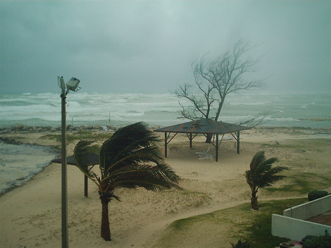
Greeting from Andros Island, Bahamas.
 
It is a sad day for many throughout the South Eastern United States devastated by Hurricane Katrina. 
 
Here on Andros the Storm got close to us initially but it was still very weak.  We experieced 20knt winds and about 3-5 hours of heavy down poors but nothing really significant.  Significant winds that are above the norm are winds 40knts or geater.  Our last big storm was Michelle in 2002 which was a high Cat 1low Cat 2 storm.   I clocked wind gusts at around 90 miles per hour with sustained winds at about 60-70 miles perhour when the eye of the storm passed directly over us.  Along the beach less then 1/2 mile away winds were clocked at 120 mph.  I live in Fresh Creek wich is located in Central Andros on the larger part of the island north of the Southern Bite.  The news media always seems to down play these storms.  You just can not imagine the severity of even a minimal hurricane. Trees were uprooted, powerlines were toppled and the beach erosion was extreme.  We are protected by a barrier reef and! still experienced heavy damage.  You can still see remenants of the storm even to this very day along the beach.
 
What I wish to say is two things one.  Do not unerestimate these storms.  As one who has gone through one these storms it should be treated as nothing less then a nuclear bomb!  GET THE HELL OUT OF DODGE!  Kiss your belongings good-bye there is nothing you can do to save them,  (what the hell are you going to do with a tv that you can not watch anyways).  These storms are that strong and they are that powerful!  A 60mph wind is nothing to pass off lightly especially if it is sustained even for 30 minutes or more.  It can be very damaging.  Secondly,  I wish to offer my services to your website for the future reference.   I am not sure if anyone from Andros reports to you.
 
Sincerely,
 
Robert N. Chapman, Jr.

- Abaco, Bahamas storm aftermath: Katrina
  • From: "shaun/mischa diehl" <s_mdiehl at hotmail.com>
  • Date: Fri, 26 Aug 2005 11:24:39 +0000
Hi Everyone!
 
Katrina blew in hard Wedneday night.  We watched the waves come in from the Atlantic off our beach.  The wind was intense for a storm, but there was little to no damage except for a few branches down and the odd tree.  We had power throughout the storm, but the Island internet systems went down for a day or two.  There was lots of rain, but this morning has the promise of sun and nice weather.  We rescued a baby bird that had fallen from a nest and was alone in the storm.  It is almost ready to fly.  It makes you realize how much the animal life is effected during weather like this, especially during major hurricanes!
 
Take care!
 
Shaun.


Don't just search. Find. MSN Search Check out the new MSN Search!

- Bye to Katrina
  • From: "HOGG" <adelphi at batelnet.bs>
  • Date: Thu, 25 Aug 2005 21:54:01 -0400
Well, Katrina has left the central Bahamas finally. In her wake she has left much flooding of low lying areas. Today was an all day driving rain day. There was little , if any blue sky. Thankfully, apart from the heavy rains and some mild damage to trees the effect, in the eastern part of New Providence has been minimal. Reports of flooding in the northern islands are yet to be confirmed.
 
As I watch the Florida news, I realise that we  have been fortunate to have experienced Katrina in her weaker state. Let's keep a close watch on the new system that seems to be organizing as it approaches our region.If you have NOT yet done your hurricane preparations for this season NOW is the time to take stock and make preparations. If nothing else, Katrina has demonstrated just how quickly a situation can change from depression to hurricane. 

- TROPICAL STORM KATRINA
  • From: "ghpsafari" <ghpsafari at batelnet.bs>
  • Date: Thu, 25 Aug 2005 12:58:48 -0400
Freeport, Grand Bahama Island
25 August 2005
1300hrs
 
All businesses appear to be operating normally in the City of Freeport. All main roads are clear, but power is still out in many areas.
Feeder bands are still affecting Freeport with very gusty winds and heavy rain as TS Katrina appears on radar to be growing in size and intensity.
Attached is a picture of a surfer's delight - the South shore at 0900 this morning.
Capt. John Roberts


Attachment: IM000588.JPG
Description: JPEG image


- Abaco Katrina conditions
  • From: Anita Rolle <anita_rolle at yahoo.com>
  • Date: Thu, 25 Aug 2005 06:45:24 -0700 (PDT)
It's Thursday August 25th and I've completed the Radio Abaco weather update for the morning.  Here on Abaco we came through this one unscathed as Katrina heads to Florida.  Though the rain and some wind is expected to continue throughout the day, both are much less intense now as Katrina gradually leaves us. 
 
No reports of actual flooding, but there's been ALOT of rain, fortunately not incessant.  I must say though, these last two days would have been the perfect test to find out whether or not you have a leak in your house roof.  If you don't have any wet walls by now, you're safe.
 
Anita.

__________________________________________________
Do You Yahoo!?
Tired of spam? Yahoo! Mail has the best spam protection around
http://mail.yahoo.com


- TROPICAL STORM KATRINA
  • From: "John Roberts" <ghpsafari at hotmail.com>
  • Date: Thu, 25 Aug 2005 08:29:40 -0400
Freeport,
Grand Bahama Island
0830
25 August 2005

Good Morning!
I am sending this on generator power as all the lights went out at 4a.m. this morning. At my rough guesstimate the winds were gusting 50+mph, and at 0430 my home barometer bottomed out at 29.58. It is now on the rise, reading 29.70.
Heavy rain with continued electrical activity most of the night.
So far the only damage we have heard of is some downed power lines and trees across the roads - hopefully this will be all!
Will advise further later.
Capt. John Roberts
www.fishermanssafari.com


- Katrina
  • From: "HOGG" <adelphi at batelnet.bs>
  • Date: Wed, 24 Aug 2005 22:24:18 -0400
Hello, Katrina has dumped inches of rain here in New Providence ( Central Bahamas). The winds have been mild with no wind damage observed in my area eastern New  Providence. The waves are larger, but so far Katrina has been an irritant ( mild to moderate flooding in some low lying areas). Economic activity continued as normal today, although the main airport suspended several flights today .The mild cooling breezes are a breif respite from the usual summer heat.
If all our stormy visitors were as well mannered as Lady Katrina.......the next few months would be fine !!


- Tropical Storm Katrina
  • From: "ghpsafari" <ghpsafari at batelnet.bs>
  • Date: Wed, 24 Aug 2005 18:06:07 -0400
Freeport
Grand Bahama Island
1800EST  24 August 2005
 
The weather at Freeport at present:
Barometric Pressure 29.84
Ceiling 1,000ft, overcast with heavy rain showers and lots of electrical activity in the area.
The centre of TS Katrina is shown approximately 100 miles SE of Freeport, heading in our general direction.
The winds all day have been around the 8-10kt. velocity.
Everyone is stocking up on water and dry goods, batteries, etc., as the average Freeporter is now an experienced hurricane survivor!
Hopefully the storm will not gain hurricane force before it reaches us, which should be before morning.
Will update tomorrow morning, GW.
Capt. John Roberts

- Abaco Update
  • From: "George Phillpot" <phillpots5 at coralwave.com>
  • Date: Wed, 24 Aug 2005 17:57:57 -0400

It looks as if Katrina is going to give us a little more than we’ve been forcasted to get. The wind and rain has steadily been increasing since noon . We had our hardest rain at about 1600  and a few hard squalls since then. It sure made a rough ride from Guana Cay to Man-O-War in a 25 ft boat but, hey, it sure beats driving down Bay Street or I-95 in rush hour traffic and rain . As I look now there is a pretty ominous squall line to our East and moving in. Anyway, we sure needed the rain even if we are still trying to repair roofs etc from last year. Some areas of Man-O-War have been out of electricity since early afternoon and I’m sure BEC will not be coming over by ferry to check it out tonight. Hopefully we do not all get knocked off or the cable goes down(with the internet).

Cheers


George Phillpot


- KATRINA
  • From: LynnBorrow at aol.com
  • Date: Wed, 24 Aug 2005 15:38:17 EDT
I'M LOCATED ON GREAT GUANA CAY IN ABACO.  WE'VE HAD HEAVY RAIN SQUALLS FOR THE PAST HOUR OR SO WITH FAIRLY HIGH WINDS.  ALL IS WELL THOUGH

- Katerina
  • From: hmaillis <hmaillis at direcway.com>
  • Date: Wed, 24 Aug 2005 14:19:05 -0400
Here in Long Island of the Bahamas we  enjoyed a fairly pleasant day yesterday but as the day drew to a close , the skies darkened and the rain squalls started. We had a wet night with a really gusty winds. This morning it is obvious that Katerina saw no need to linger here, having seen the farmers plight and poured her tears to their relief, she is moving to the northwest leaving overcast skies to keep our much needed moisture from evapourating in summer sunshine. 
There are a couple of anxious fishermen's wives though. If anyone has news on the Bahama Raider they would be grateful. They went crawfishing on the banks and were caught in this weather.

- Bahamas, Wednesday 24 August 2005
  • From: "Adrian Chriswell" <abchriswell at hotmail.com>
  • Date: Wed, 24 Aug 2005 17:42:24 +0000

I am in Freeport, Grand Bahama this week. Started experiencing some shower squalls about one hour ago. I have not looked at radar or satellite image since 0700, but expect more showers over next 24 hours as it comes up over and past Nassau. Freeport really does not need anything like last year's 2 hurricanes. Place has still not fully recovered. This is my first trip here since last July, and I still still much work to be done.

Adrian


Get MSN Messenger with Video Conversation - FREE. The next best thing to being there.

- Tropical Storm Katrina (Central Bahamas)
  • From: Kimberly King-Burns <kkingburns at convergenz.com>
  • Date: Wed, 24 Aug 2005 09:01:34 -0700
BULLETIN
TROPICAL STORM KATRINA ADVISORY NUMBER  4
NWS TPC/NATIONAL HURRICANE CENTER MIAMI FL
11 AM EDT WED AUG 24 2005

...DEPRESSION STRENGTHENS INTO TROPICAL STORM KATRINA OVER THE
CENTRAL BAHAMAS...
...HURRICANE WATCH AND TROPICAL STORM WARNING ISSUED FOR FLORIDA...

AT 11 AM EDT...1500Z...A TROPICAL STORM WARNING AND A HURRICANE
WATCH HAVE BEEN ISSUED FOR THE SOUTHEAST FLORIDA COAST FROM VERO
BEACH SOUTHWARD TO FLORIDA CITY. THIS REPLACES THE TROPICAL STORM
WATCH.  A HURRICANE WATCH MEANS THAT HURRICANE CONDITIONS ARE
POSSIBLE WITHIN THE WATCH AREA...GENERALLY WITHIN 36 HOURS.

A TROPICAL STORM WARNING REMAINS IN EFFECT FOR THE CENTRAL AND
NORTHWEST BAHAMAS.  A TROPICAL STORM WARNING MEANS THAT TROPICAL
STORM CONDITIONS ARE EXPECTED WITHIN THE WARNING AREA WITHIN THE
NEXT 24 HOURS.

A TROPICAL STORM WATCH REMAINS IN EFFECT FOR THE MIDDLE AND UPPER
FLORIDA KEYS FROM WEST OF THE SEVEN MILE BRIDGE NORTHWARD TO SOUTH
OF FLORIDA CITY.  A TROPICAL STORM WATCH MEANS THAT TROPICAL STORM
CONDITIONS ARE POSSIBLE WITHIN THE WATCH AREA...GENERALLY WITHIN 36
HOURS.

A WATCH OR WARNING MAY BE REQUIRED FOR LAKE OKEECHOBEE LATER TODAY.
A HURRICANE WARNING MAY BE REQUIRED FOR PORTIONS OF THE NORTHWEST
BAHAMAS LATER TODAY.

FOR STORM INFORMATION SPECIFIC TO YOUR AREA...INCLUDING POSSIBLE
INLAND WATCHES AND WARNINGS...PLEASE MONITOR PRODUCTS ISSUED
BY YOUR LOCAL WEATHER OFFICE.

AT 11 AM EDT...1500Z...THE CENTER OF TROPICAL STORM KATRINA WAS
LOCATED NEAR LATITUDE 24.7 NORTH... LONGITUDE 76.7 WEST OR ABOUT 50
MILES... 80 KM... EAST-SOUTHEAST OF NASSAU AND ABOUT 230 MILES...
375 KM...EAST-SOUTHEAST OF SOUTHEAST COAST OF FLORIDA.

KATRINA IS MOVING TOWARD THE NORTH-NORTHWEST NEAR  8 MPH
...13 KM/HR. A GRADUAL TURN TOWARD THE NORTHWEST AT A SLIGHTLY
SLOWER FORWARD SPEED IS EXPECTED TO OCCUR LATER TODAY. THIS MOTION
SHOULD BRING THE CENTER THROUGH THE CENTRAL AND NORTHWEST BAHAMAS
LATER TODAY AND TONIGHT.

EARLIER REPORTS FROM AN AIR FORCE RESERVE RECONNAISSANCE AIRCRAFT
INDICATED MAXIMUM SUSTAINED WINDS HAD INCREASED TO NEAR  40 MPH...
65 KM/HR...WITH HIGHER GUSTS. ADDITIONAL STRENGTHENING IS FORECAST
DURING THE NEXT 24 HOURS.

TROPICAL STORM FORCE WINDS EXTEND OUTWARD UP TO  70 MILES
...110 KM...MAINLY EAST OF THE CENTER.

THE ESTIMATED MINIMUM CENTRAL PRESSURE IS 1006 MB...29.71 INCHES.

DUE TO ITS SLOW FORWARD SPEED...KATRINA IS EXPECTED TO PRODUCE A
SIGNIFICANT HEAVY RAINFALL EVENT OVER THE CENTRAL AND NORTHWEST
BAHAMAS...AND SOUTH FLORIDA... WITH TOTAL RAINFALL ACCUMULATIONS OF
6 TO 12 INCHES AND ISOLATED MAXIMUM AMOUNTS OF 15 TO 20 INCHES
POSSIBLE.

STORM SURGE FLOODING OF 3 TO 5 FEET ABOVE NORMAL TIDE LEVELS...
ALONG WITH LARGE AND DANGEROUS BATTERING WAVES... CAN BE EXPECTED
NEAR THE CENTER IN AREAS OF ONSHORE WINDS IN THE BAHAMAS.

REPEATING THE 11 AM EDT POSITION...24.7 N... 76.7 W.  MOVEMENT
TOWARD...NORTH-NORTHWEST NEAR  8 MPH.  MAXIMUM SUSTAINED
WINDS... 40 MPH.  MINIMUM CENTRAL PRESSURE...1006 MB.

AN INTERMEDIATE ADVISORY WILL BE ISSUED BY THE NATIONAL
HURRICANE CENTER AT 2 PM EDT FOLLOWED BY THE NEXT COMPLETE
ADVISORY AT 5 PM EDT.

FORECASTER STEWART


- Conditions in the Abacos
  • From: Anita Rolle <anita_rolle at yahoo.com>
  • Date: Sun, 24 Jul 2005 05:27:25 -0700 (PDT)
Great to be back on here again! Though Franklin has passed us now, there's still somewhat of a thick cloud covering over Central Abaco this Sunday morning.  The majority of the flights were cancelled out of here on Friday, however, the airport is gradually getting back to a schedule. 
 
This active hurricane season 2005 is not being welcomed at all by Abaconians...many are STILL trying to recover emotionally from Frances and Jean of 2004 (more than would admit it).  Yes, the buildings may have been repaired, the water might have dryed, but the scars left from having to go through the process will take a little longer to mend.
 
Be safe everyone!!
 
Anita.

__________________________________________________
Do You Yahoo!?
Tired of spam? Yahoo! Mail has the best spam protection around
http://mail.yahoo.com


- From the Abacos
  • From: "George Phillpot" <phillpots5 at coralwave.com>
  • Date: Sat, 23 Jul 2005 07:09:16 -0400

Well, Franklin paid us a visit yesterday and finally we get a visitor that doesn’t like our hospitality. I guess he really didn’t intend to stay that long as he didn’t bring the usual luggage that we saw so much of last year. Here in Man-O-War we had a few strong gusts early on in the morning( I would guess about 35-40 with the leaves etc blown around) and then just light showers until noon. After noon it really belted down and we caught about 5 inches of rain in a five gallon bucket left out in the yard. A few of the showers also carried strong winds but, as my wife said’ I can handle Hurricanes like this’.

This morning it is flat calm with overcast skies and the cicadas are out in full force so it looks as if we made out excellent.


George Phillpot


- Franklin
  • From: Sandra Pitt <romperpitt at yahoo.com>
  • Date: Sat, 23 Jul 2005 03:53:43 -0700 (PDT)
This is Sandra Pitt in San Salvador Bahamas.
 Nothing to report from here slight breezees & very little rain, which we need !!!! Believe The Abaco's got more rain !!!.
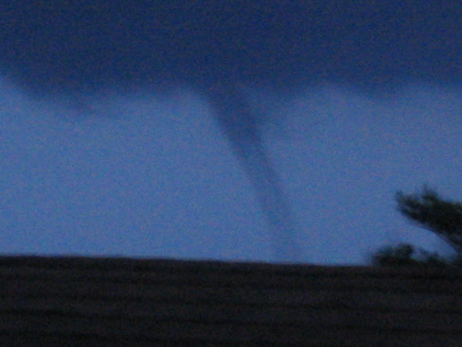
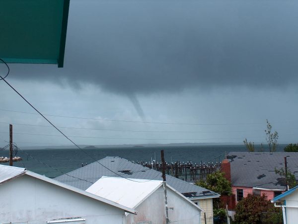
__________________________________________________
Do You Yahoo!?
Tired of spam? Yahoo! Mail has the best spam protection around
http://mail.yahoo.com


- Great Guana Cay
  • From: Pat Weatherford <guanaloverpat at yahoo.com>
  • Date: Fri, 22 Jul 2005 12:52:12 -0700 (PDT)
Its been raining off and on since 2 am. In the last hour, the rain has been coming in strong squalls. I haven't been able to check my rain gauge but at noon it was at 2 inches. Its coming down so hard that I can't see the boats in the Orchid Bay marina. We needed this rain so its a welcome site. Power is still on, phones work and internet service is still up so I would say we made out pretty good.
Just sighted a water spout heading down the Sea of Abaco.
Pat Weatherford
Great Guana Cay
Abaco, Bahamas


Pat Weatherford

__________________________________________________
Do You Yahoo!?
Tired of spam? Yahoo! Mail has the best spam protection around
http://mail.yahoo.com

JPEG image


- Great Guana Cay, Bahamas
  • From: "pat weatherford" <patw at abacoinet.com>
  • Date: Fri, 22 Jul 2005 14:37:06 -0400 (Eastern

JPEG image


- Franklin Update: Abaco, Bahamas
  • From: "shaun/mischa diehl" <s_mdiehl at hotmail.com>
  • Date: Fri, 22 Jul 2005 17:10:52 +0000
Hi Everyone!
 
The Abacos are getting a good downpoor and soaking with Franklin.   Yesterday evening started with some rain and then lightning storms.  Winds were moderate.  The worst was during the night and the stuff on my deck is still in it's place so it was not too bad.  Today we have seen steady rain and overcast sky.  The sea is rough but there is no cause for alarm.  Our water table and plants are enjoying this welcome break to the heat.  It's a good day for a good book!
 
Shaun
 
Bahama Palm Shores, Abaco, Bahamas.


Express yourself instantly with MSN Messenger! MSN Messenger Download today it's FREE!

- Emily in the distance- long distance
  • From: "HOGG" <adelphi at batelnet.bs>
  • Date: Wed, 13 Jul 2005 00:23:10 -0400
Hello again. Its just mid July and already we are at E. Here in New Providence, Bahamas ,life goes on as normal.THis past weekend we spent celebrating the birth of our nation (July 10th 1973) and particip[ating in numerous sporting events. Still, folks are keeping a watchful eye on the systems, especially now that Emily is officially a storm. Dennis dropped moderate rains on us but was otherwise essentially a non-event here.Let us hope that Emily proves to be a quiet one for us all.
Bridget Hogg

Back to top | home | tools | pleas for help | QHWRN | guide | climatology | archive