
|
|
- Updates from the Islands -- - Antigua - - |
|
|
More recent 2003 reports can be found elsewhere
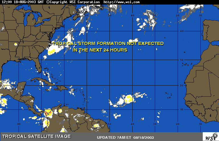
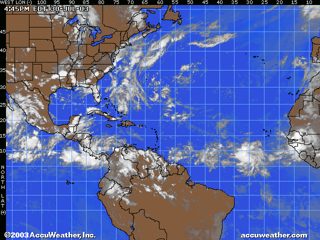
| - ATLANTIC'S SHOT SO FAR |
|
CLICK ON ATTACHED SITE THIS MAY AROUSE SOME OF THE BOYS IN THE BACK ROOM THE LAST THING TO DO THAT WAS A REPORT ABOUT A VIRGIN MERMAID Your files are attached and ready to send with this message. |
| - THAT TIME OF THE YEAR! | ||||||
| ||||||
|
| - RAIN RAIN RAIN !!! |
|
Over the last few hours, Antigua has been inundated with rain. The sky is currently completely overcast (full 8 oktas). Here is a pictures of the view from Cable & Wireless looking south towards the Shekerly mountains. Visibility was down to about 2 miles in this picture: Alan B. Scholl http://www.digitalphoto.ag/scholla Amateur Radio: V21BF Antigua, West Indies - "Where Land & Sea Make Beauty..." |
| - Still to the "west" |
|
|
Some welcoming showers this morning...the Atlantic seems to become a bit more active during the past few days. There are two active system we are monitoring in the tropical Atlantic and another one inland over Africa expected to move off the coast in a couple of days. Subsidence exist in the Atlantic around 25-48W:10-20N and seems to inhibit rapid development of system that move into that vincinity such as the tropical wave along 31W but the subsidence is expected to lift a bit to the north during September and provide a more favourable environment for tropical cyclone development. So far, the tropical Atlantic(East of 60W) had not yeild a single storm as yet...but soon............ Add photos to your messages with MSN 8. Get 2 months FREE*. |
| - SATURDAY | ||||||
| ||||||
|
| - NO RAIN :( |
|
|
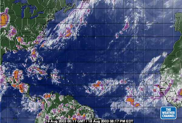
The system move through the Eastern Caribbean Islands today bringing heavy showers to the windward islands, but guess what......not a single drop of rain fell on Antigua.
The ML-Enhanced SAT(IR/WV/Visible) below shows what the system looked liked this morning. Right now,its somewhat weaker.
 The new MSN 8: smart spam protection and 2 months FREE* |
| - Today | ||||||
| ||||||
|
| - BETTER NEWS than last time!! | ||||||
| ||||||
|
| - TS FABIAN AND GRACE???? | ||||||
| ||||||
|
| - GRACE????? | ||||||
| ||||||
|
| - Tropical Atlantic Satellite | |||||||||||||||||||||||||||||||||||||||||||||||||||||||||||||||||||
| |||||||||||||||||||||||||||||||||||||||||||||||||||||||||||||||||||
| |||||||||||||||||||||||||||||||||||||||||||||||||||||||||||||||||||
| - THAT WAVE!!! | ||||||
| ||||||
|
| - DROUGHT RELIEVE |
|
|
We got a temporary relieve from the short drought we had a few days ago. This morning(and now), we had a nice cool showers, a blessing from heaven. Hopefully more would come.
As for the Tropical Atlantic, it looks even more worthless than last year's already fruitless season(at least for now). So far, all the major systems that developed(from Ana-Erika) spawn in the Gulf, Sub-Tropical Atlantic and the Caribbean Sea. Non of which developed in the Tropical Atlantic(guess neutral ENSO and dry air/subsidence play a major role). Only 2-3 of the 7 depression developed in the Trop. Atlantic and they are short lived. We have already entered the busiest part of the hurricane season but the Atlantic still look unusually quiet although a couple of system is out there playing games. What lies ahead is very uncertain, watching and waiting is the best option. STOP MORE SPAM with the new MSN 8 and get 2 months FREE* |
| - rain drops keep falling!!!! | ||||||
| ||||||
|
| - Watching off of AFRICA again | |||||||||
| |||||||||
|
| - MARS from ANTIGUA | ||||||||||||
| ||||||||||||
| ||||||||||||
| - DORMANT |
|
|
Its frying globally, Europe, Asia, N. America and to a lesser extent, the Caribbean. Earlier today, the Max. temperature here hover around the 90's, thanks to the sea-breeze or we would be baked alive under the blazing tropical sun. Thats not all, looks like we're in for another short drought, the nearest tropical wave that could promise some rain is over five days away and we hadn't got any significant rainfall for the past week or so, the water tank is drying out. There seems to be a lag in the wave chain propagation because of some upper trough and the wave is moving real slow....Damn it. WE NEED RAIN!!! Add photos to your e-mail with MSN 8. Get 2 months FREE*. |
| - DOG DAYS | |
| |
|
| - the next couple of months???? | |||||||||
| |||||||||
|
| - A another satellite photo | ||||||
| ||||||
|
| - ANTIGUA FROM SPACE | ||||||
| ||||||
|
| - 4 AM update | ||||||
| ||||||
|
| - Tuesday night... | ||||||
| ||||||
|
| - Developing?????????? |
|
|
Got a few heavy showers an hour or so ago, but its Carnival Tuesday and Last Lap..WHAT DO WE CARE!!
The wave looks impressive to the east of us with a 1013MB Low near 16N. The latest IR Sat included shows what seems to be some convection curling around the low pressure center, I am not too sure since NHT report the wave axis along 58W, the wave is probably infront of the low. Help STOP SPAM with the new MSN 8 and get 2 months FREE* |
| - another update | ||||||
| ||||||
|
| - TUESDAY early morning report | ||||||
| ||||||
|
| - error in math!!! | ||||||
| ||||||
|
| - STILL WATCHING ???TD #7 | ||||||
| ||||||
|
| - RAIN STORMED.......... |
|
|
Its been a rainy night, my rain gauge recorded over 1 inch of rain just for today alone which is a rare occasion since this year begun. It has been raining on and off since 4:00PM(local time) climaxing at 8:25PM. The heavy down pour was non-stop for over half an hour! There was a weak attack of lightning through out the whole night but only a couple blast of thunder sounded. Right now, the sky is still very cloudy. Anyway, the people are still Jamming hard in 'Lions' and "Shanty Town". Its only two days away from Carnival Monday in Antigua. Peeps are getting quiet excited, the 'shows' at ARG(Antigua Recreation Ground) is already half way through. I wish the representatives from the Caribbean islands participating in the Jaycees Pageant good luck! For those of you who wish to get a glance of the notorious Antigua Carnival visit www.antiguacarnival.com or just use the search engines.
Back to the tropical wave located 850NM east of Barbados. Well, it look less organized tonight but advance observation shows a more or less the same system as 24 hrs ago. Convections had weaken somewhat during the past 24 hours...BUT the remaining convections had moved closer to the center of the system and vortecity are better defined, it has also slowed down to 15mph. In fact, the system had moved north-west(away from the ITCZ) during the past few hours(showing independency). With warm SST and favorable upper level easterlies, would this wave become a tropical cyclone or just another scare like tropical depression six...??? The new MSN 8: smart spam protection and 2 months FREE* |
| - sounds like good news to me! | ||||||
| ||||||
|
| - TROPICAL DEPRESSION #8 ???THEN ERIKA | ||||||
| ||||||
|
| - ANOTHER STORM SCARE?????? OR WAS IT?...WE ARE ALMOST IN AUGUST!! |
|
|
Had some heavy showers last night and this morning, rather refreshing.
Tropical systems in the tropical Atlantic this season seems to be in a hurry. A fast moving but impressive looking tropical wave(along 35W) witha 1010mb low pressure center along 9N is moving west rather quickly. Earlier satellite pics shows a well organised/defined system with good banding features. However, the center is not so well defined(like TD#6) and was not under the canopy of deep convections although convection in general was more abundant than TD#6. BUT...It could still be TD#8 in the near future...though not necessarily. Add photos to your messages with MSN 8. Get 2 months FREE*. |
| - Potential storm development? |
|
Last night brought some VERY HEAVY showers in the St.Johns area. About half hour ago, there was more shower activity in the Clare Hall area. It is still slightly overcast but the sun is peeking out. Seems like there could be some development of the cloud mass about half way between Africa and the Caribbean. Visually, it seems to show some circulation. I suspect the 5PM report will have us on the alert. Alan B. Scholl http://www.digitalphoto.ag/scholla Amateur Radio: V21BF Antigua, West Indies - "Where Land & Sea Make Beauty..." |
| - THAT WAVE ???ERIKA | ||||||
| ||||||
|
| - AUGUST |
|
|
Title: Message
THE BOYS WENT DOWN
TO THE BEACH THIS MORNING TO CHECK OUT THE SEA TEMPERATURE.
THEY DECIDED IT
WASN'T WARM ENOUGH TO SWIM AS YET-IT WAS ONLY 82F.
THEY CHECKED THE
SAND FOR MERMAID TRACKS,FOUND NONE AND TRUDGED BACK TO THEIR
HUT,
AND I HEARD THEM
MURMURING SOMETHING ABOUT ERIKA FROM AFRICA-I COULDN'T QUITE MAKE IT
OUT.
MAYBE SHE WAS SOME
LONG LOST MERMAID FRIEND OF THEIRS-I DON'T KNOW-THEY ALWAYS BLAMED THEIR LAST
WRECK ON THAT REEF EAST OF BARBUDA ON A MERMAID.WHO IS
ERIKA?
AUGUST COME THEY
MUST.
|
| - An Environmental Emergency! | ||||||
| ||||||
|
| - SUNSHINE AGAIN | ||||||
| ||||||
|
| - rain rain GO AWAY!!! | ||||||
| ||||||
|
| - RAIN DROPS ARE FALLING... | ||||||
| ||||||
|
| - Getting brighter... |
|
Although we had a few earlier showers, the sun is out and it is hot! It is still a bit hazy looking to the south but there is a light breeze and the cumulus clouds are drifiting by. Alan B. Scholl http://www.digitalphoto.ag/scholla Ham: V21BF Antigua, West Indies - "Where Land & Sea Make Beauty..." |
| - Overcast but no significant rainfall :-( |
|
It has been overcast all day but no significant rainfall at all. There was a shower about 1 1/2 hours ago but it did not last very long. Alan B. Scholl http://www.digitalphoto.ag/scholla Ham: V21BF Antigua, West Indies - "Where Land & Sea Make Beauty..." |
| - storm band? |
|
At approximately 1:05PM, we had a splash of some very bad weather. Sustained winds of 20-25knots with higher gusts and lots of rain. However it only lasted for about 10 minutes. Had me worried for a bit until it subsided Alan B. Scholl http://www.digitalphoto.ag/scholla Ham: V21BF Antigua, West Indies - "Where Land & Sea Make Beauty..." |
| - GOOD NEWS ON TD #6 | ||||||
| ||||||
|
| - Quick Update |
|
|
Hi all, just a quick word to let you know the condition here at 1:30PM Local Time. The sky is now overcast when slight to moderate showers on and off. The wind had picked up slightly(about 18-20mph) with two isolated gust of 25.6mph and 24.8mph respectively. These weather are expected to continue in spurts throughout today as burst of convection move across Antigua. Tired of spam? Get advanced junk mail protection with MSN 8. |
| - Quickly and surely..... |
|
|
Hey, hope you peeps down south are safe and sound. All activities remain normal in Antigua with a few banging here and there.
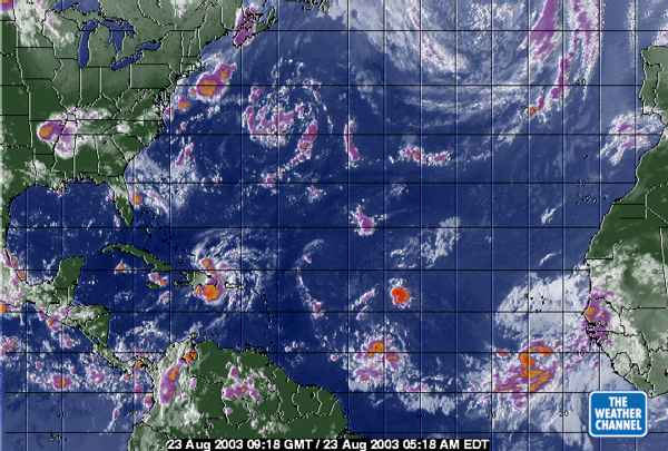
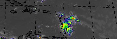
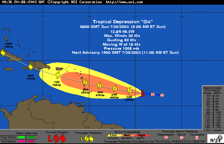
It was sunny in Antigua this morning but right now(at 12:30EDT), it is partly cloudy with occasional showers. Maximum wind gust for the day so far recorded here in Belmont(near St.John's) is 24.5mph(15 mins. ago). Visibility is poor and the barometer droped slight over the past few hours. We expect the weather to deterriorate a bit more as TD#6 move through the Northern Windward Islands. Everything however, should abate to normal by Tuesday afternoon. The Depression show no signs of slowing down(remains at 23mph/20knots) while lower level easterlies continues to hinder rapid development.
The Visible satellite imagery shown below taken at 12:30EDT shows the system just east of Martinique. The aqua color circles represent possible wind field distribution. The green dots represent possible track of the cyclone during the next 24 hours.
 Tired of spam? Get advanced junk mail protection with MSN 8. |
| - Rain and overcast |
|
We had a heavy shower about an hour ago. The sky is dark grey, completely overcast and as I write this, the rain has once again started in the Clare Hall area, It is getting heavy but there is no wind as such. Alan B. Scholl http://www.digitalphoto.ag/scholla Ham: V21BF Antigua, West Indies - "Where Land & Sea Make Beauty..." |
| - 11 AM UPDATE | ||||||
| ||||||
|
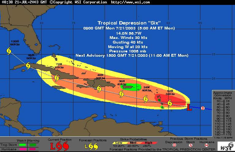
| - TROPICAL DEPRESSION 6 UPDATE | ||||||
| ||||||
|
| - * |
|
|
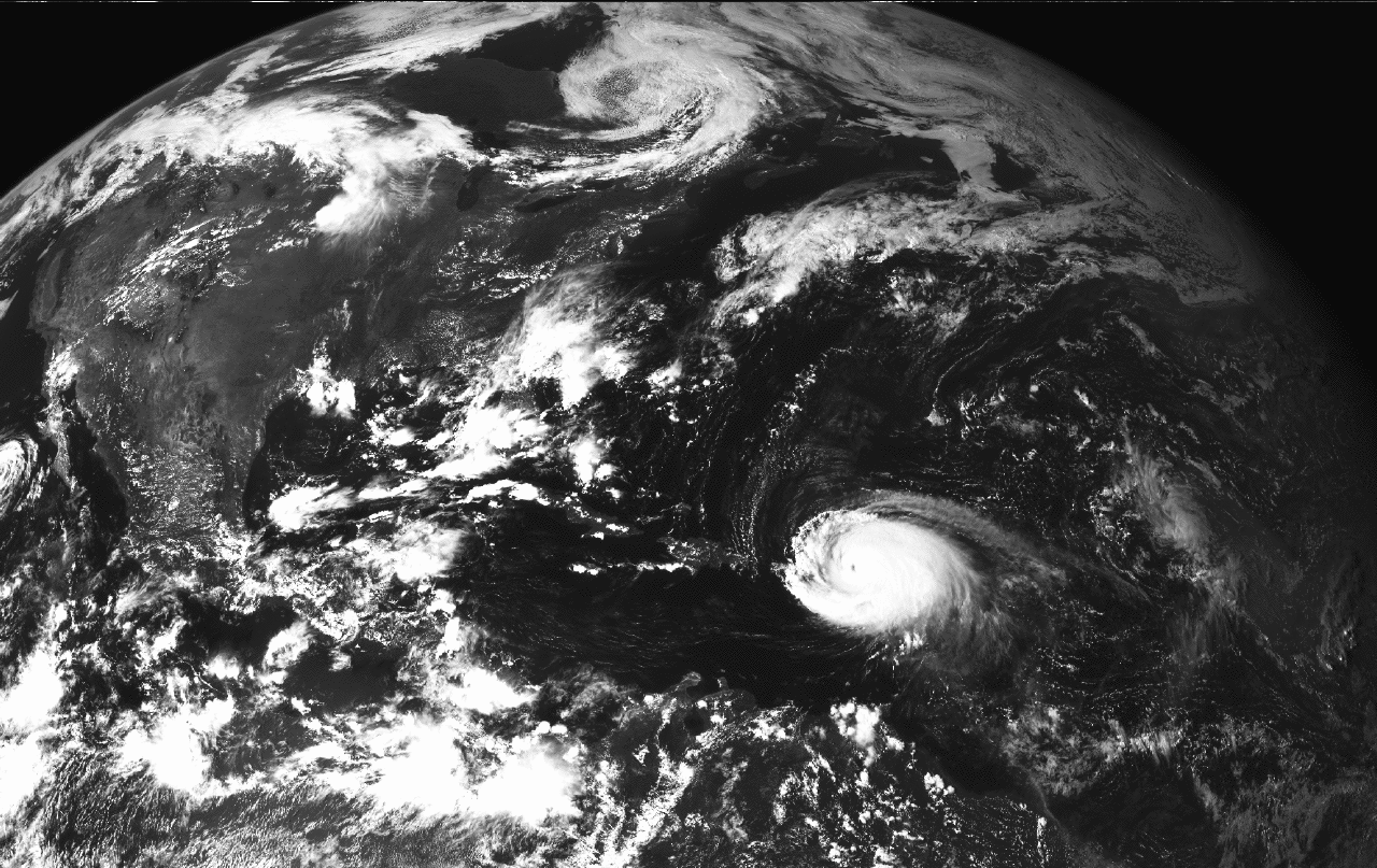
Based upon the 11:00AM bulleting and report, TD#6 is moving westward near 23mph. This is quiet a fast speed for a depression and at this speed, remaining its organization is difficult for any tropical system much less for strengthening. The 11AM IR-SAT and Visible shown TD#6 as a frail system with little banding features. If the depression continues to move at this speed or faster, it would probably dissipate. Nevertheless, the system as a whole seem well organized at the moment and the environment ahead are favorable for intensification, the system could still become a tropical storm before crossing the Lesser Antilles.
The strength and latitude in which the system impacting the islands will depend mainly on its forward speed and direction. The slower it moves, the more time it would get to develop further before impact and the higher the chance of it shifting northward(closer to Antigua and the Leeward), HOPE NOT! Tired of spam? Get advanced junk mail protection with MSN 8. |
| - SUNDAY 5 am projected track | ||||||
| ||||||
|
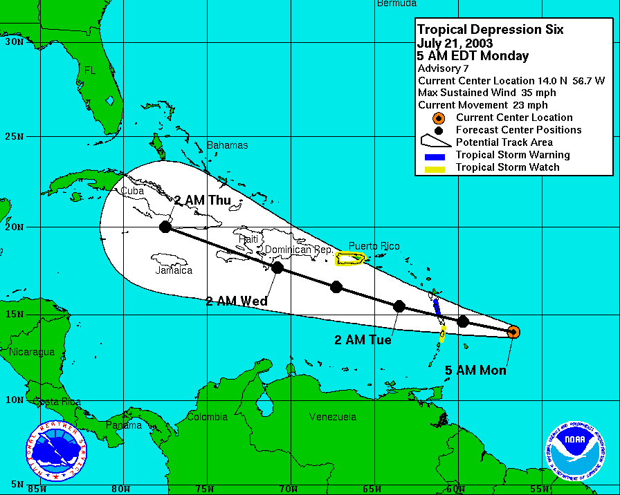
| - Another one....? |
|
|
Well...., look like its time for us after the US was hit left, right and center. Tropical Depression Six might well be Erika soon. It could even strenghten to a hurricane before striking the Estern Caribbean Islands given that the upper level wind shear is so low ahead unless dry air move into the storm. We just got to wait n' c.
The forcast track for the storm/system is shown here(green circle is the probable strike area). Protect your PC - Click here for McAfee.com VirusScan Online |
| - THIS...I DON'T LIKE! | ||||||
| ||||||
|
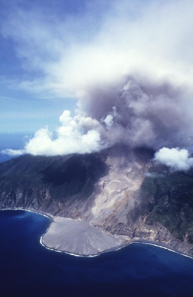
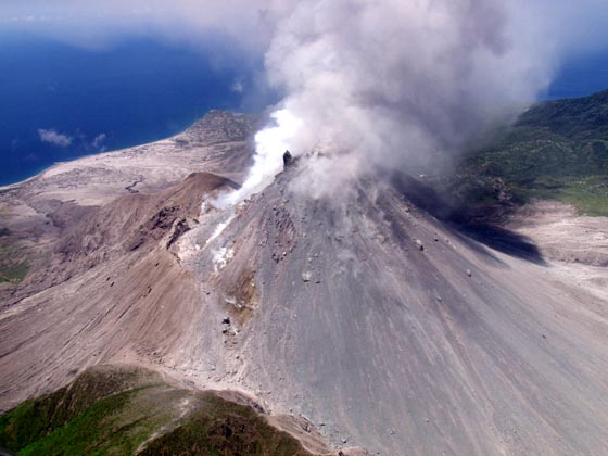
| - MONTSERRAT VOLCANO | ||||||
| ||||||
|
| - Update |
|
|
So far, there has been no major ash fall event in Antigua after the major explosion on the 12/13 July. Thanks to the wind.
The top section of the large tropical wave located along 50.5W(about 900 miles away) has broken into a trough. This trough continues to show signs of development base on the SAT pictures but may be to far north to pose a threat to the Caribbean islands. The tropical wave itself(south of 21N) is relatively dry with hardly any convective activity probably caused by the large anticyclonic flow to the east of the Leeward Islands. Help STOP SPAM with the new MSN 8 and get 2 months FREE* |
| - MONTSSERRT VOLCANOE | ||||||
| ||||||
|
| - wonderful rain | ||||||
| ||||||
|
| - Update |
|
|
Hi, its SUN, SEA and SAND in Antigua, very sunny with a bit of haze and moderate breeze.
If we turn our attention to the east, we should see a strong tropical wave moving off the African coast. Seem as though the African Monsoon is becoming more active as the August days drew nearer. This wave do seem threatening, worth monitoring. The new MSN 8: smart spam protection and 2 months FREE* |
| - WEATHER WEATHER..and RAIN | ||||||
| ||||||
|
| - Storm's Brewing |
|
|
Hi, Greetings Everyone. Special greetings to the 'Mermaid'.
Sky over Antigua over past few hours ranged between partly cloudy to very cloudy and during the past hours or so, there has been intermittent heavy rainfall with winds for the whole day around 18-25mph with a few gust to excess of 30mph. These winds are probably due to the tight pressure gradient cause by the high pressure system to the north-east and even more so as the tropical low to the south squeez closer to the island chain. From the 5p.m. IR-SAT Imagery, it look as though St. Lucia and Martinique is starting to get the worst of the system. We in Antigua are also expecting a slight taste of it later tonight as bands of convection move northward. Anyway, we need a hell lota rain after that severe drought we had. Deep Convection has redeveloped during the past few hours around the center, its gona be a 50/50 chance of the system becoming a tropical depression dispite its disorganize characteristics.
Thats it for now. We'll keep you informed of the local situation. MSN 8 with e-mail virus protection service: 2 months FREE* |
| - Emailing: MIADSAAT | |||||||||||||||||||||||||||||||||||||||||||||
| |||||||||||||||||||||||||||||||||||||||||||||
Title: Message
| |||||||||||||||||||||||||||||||||||||||||||||
| - FIREWORKS FOR YOUR HAPPY JULY 4th | |||||||||||
| |||||||||||
|
| - LOVERLY |
|
|
Title: Message
SQUALLY,RAINY,BLUSTERY.AN ILLUSION.NOT MUCH BEHIND
IT.
THE BOYS IN THE BACK
ROOM SAY IT'S TOO EARLY FOR THEIR MIDSUMMER BATH.THEY SAY IT'S ONLY ENOUGH RAIN
TO SOAP UP AND NOT ENOUGH TO RINSE OFF!
|
| - AN EARTHQUAKE | ||||||||||||||||||||||||||
| ||||||||||||||||||||||||||
|
| - MORE EXCITING TALES THAN HURRICANES | ||||||
| ||||||
|
| - RAIN lovely RAIN ! |
|
Beautiful rain awoke us this morning. It is still raining sine about 4AM or so. The sky is completely overcast and it seems like this is what is in store for us today. At this point we need even more s our ponds are still pretty empty. Alan www.digitalphoto.ag |
| - more RAIN!!! |
|
Hi All, I wrote too soon, the heavens are blessing us. The rain is not very heavy but it is a start. Alan http://www.digitalphoto.ag/scholla Ham: V21BF Antigua, West Indies - "Where Land & Sea Make Beauty..." |
| - Overcast but no rain yet... |
|
Hi All, Overcast in the southeast with a few dark grey clouds. No rain yet but we are hopeful... Alan http://www.digitalphoto.ag/scholla Ham: V21BF Antigua, West Indies - "Where Land & Sea Make Beauty..." |
| - BARBUDA | |
| |
|
| - RAIN | |
| |
|
| - RAIN RAIN RAIN!!! |
|
Hi All, BEAUTIFUL RAIN!!! We are inundated with showers of blessing in Antigua right now. A heavy rain shower started at 7:15AM and kept going to 7:45AM. The sky is completely overcast with visibility down to about 5 miles. It is now 12:35PM and is still very overcast with an ocasioal heavy shower. FINALLY... Alan B. Scholl http://www.digitalphoto.ag/scholla Ham: V21BF Antigua, West Indies - "Where Land & Sea Make Beauty..." |
| - MORE FISH TALES | ||||||
| ||||||
|
| - p.s. | |
| |
|
| - BREEZE | |
| |
|
| - JUNE |
|
|
Title: Message
IF THE HURRICANE
SEASON STARTS ON JUNE 1ST WHAT IS THE BIG DEAL?
AND WE NEED THE
RAIN
THE BOYS ARE TIRED
OF WASHING IN SALT
WATER
AND SCANNING THE HORIZON FOR NON-EXISTANT
MERMAIDS
|
| - FISHIING FUN... over the moon???? | ||||||
| ||||||
|
| - THE WINNING BOAT | ||||||
| ||||||
|
| - ANTIGUA FISHING | ||||||
| ||||||
|
| - OF MERMAIDS AND BAD BOYS AND STORMS | |
| |
|
| - START OF HURRICANE SEASON | ||||||
| ||||||
|
| - HOT AND DRY | ||||||
| ||||||
|
| - ANTIGUA CLASSIC WEEK | ||||||
| ||||||
|
| - MONTSERRAT VOLCANOE | ||||||
| ||||||
|
| - VOLCANOES/ STORMS AND SAILING | ||||||
| ||||||
|
| - ANNA WHO? | |
| |
|
| Back to top |


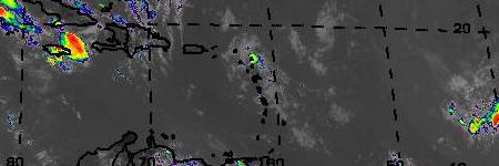
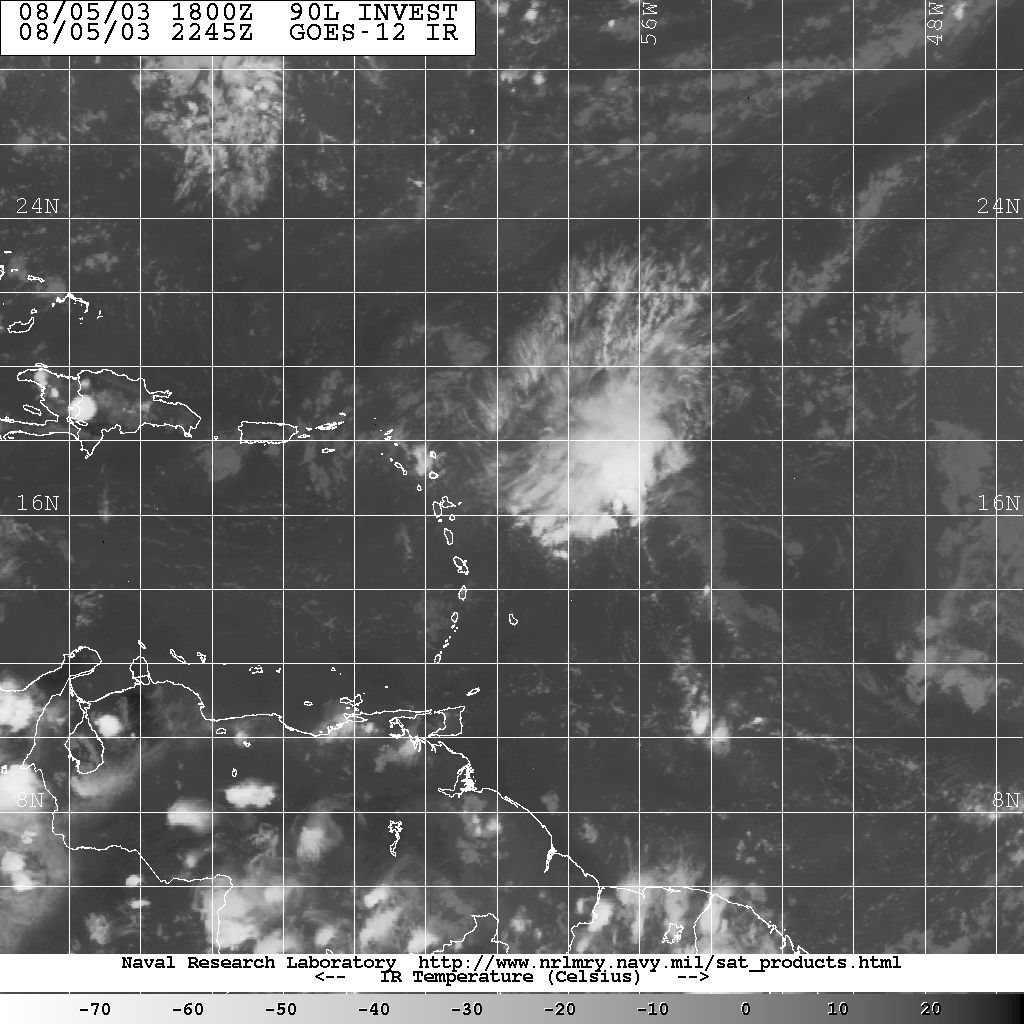
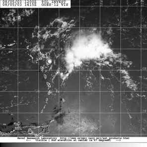
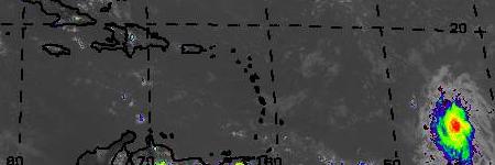
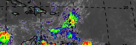
 Just a couple of days ago the experts thought this wave just coming upon the Leewards could be named FABIAN...and now it looks like it wont even bring us any rain...looking at the top sat pic below... Antigua and Barbuda is just above any clouds... and at this time it is nice and sunny!! however the lower moving sat pic does give us some cloud cover... so maybe some rain will be forthcoming! If there is any strengthening as mentioned below it will be after it is well past us!
  GOES Puerto Rico SECTOR Water Vapor Image
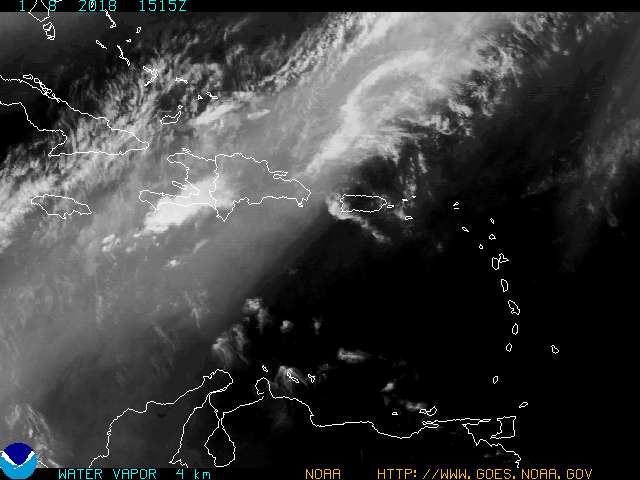
 6 a.m!!! AND WATCHING!!


 mass (bringing FLOWERS TO OUR GARDENS)
 on that wave mentioned below (and barely shown above on the far
 sea is flat calm.. not a puff of air blowing..even on the EAST COAST...great boating day......
  ...since it is way down around 10 degrees that is not good news for Antigua if it develops!!!
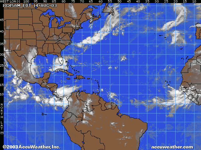

 as Antigua is the dot on the sat image below IN THE CLEAR (just above butterfly shape island) so much to do about nothing it appears!! Guess the holiday makers will have a beautiful day after all!!!
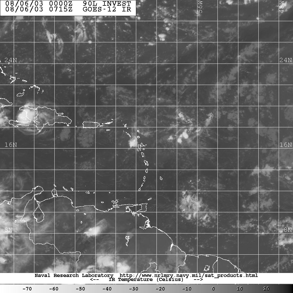
 and cant worry about a few puffs!! but i am still watchin it....
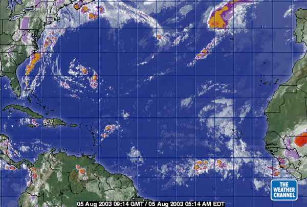
 WRONG CALCULATION..
  MY GENERATION is ELECTRONICALLY ORIENTED AND SHOULD NEVER ATTEMPT MATH WITHOUT A CALCULATOR!!
  This wave (which we have been talking about since LAST THURSDAY!!)
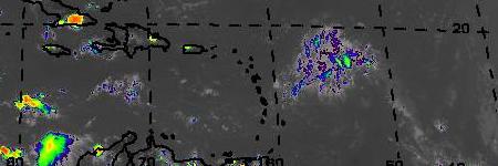
 . this i like!!! but will still watch it!


 during the night


 LAST NIGHT JUST AROUND 8 P.M. WAS HAVING DINNER WHEN THE EARTH MOVED!! literally!! See below and Antigua is that little StAR on the map!!!


 The sea is buzzing with fishing boats competing for some big prizes! For those interested you can check out thier web site below...
 AND TAKE NOTE! ANTIGUA...AND MOST OF THE ISLANDS .... HAVE BEEN SPARED THE LAST 2 YEARS OF HURRICANES AND SOME PEOPLE GET SLACK IN BEING PREPARED! THIS YEAR IS EXPECTED TO BE MORE ACTIVE SO WE SHOULD ALL TAKE NOTE AND PREPARE EARLY! For those of you who check the hurricane reporting site... just to reassure you.. your "reporters" are here and will do our best to keep you informed of what is going on... but let's hope you don't hear from us too often!
  Our weatherman reported last night that this April is the DRIEST IN 12 YEARS... great for beach goers (and this is a holiday weekend with MOnday being Labour Day- so lots of beach pic nics etc)... but our LAND NEEDS WATERING!
  our poor livestock appear to be eating DIRT as you drive past the pastures. So.. any of you with any direct connection to the Great rainmaker... please try to send some our way! Until later ...


