
|
|
- Updates from the Islands -- - Antigua - - |
|
|
More recent reports can be found on another page.
| - Poor Organization |
|
|
Weather is all clear this morning,expect so for the rest of the day.
All weather disturbance in the Atlantic weakens. Get your FREE download of MSN Explorer at http://explorer.msn.com |
| - Update | |
| |
|
| - Strange trend......? |
|
|
Another thing,on a hunch,the reason why so far,most of the system develope or become better organize in the west (after 40W) instead of the east is probably due to the influence of Warm Sea Temperature<above 27degrees>(which is presently confine/restricted to after 42W) and High Pressure,Ridge,Troughs(which affect the upper-level winds and other wind flows).And also due to the influence of other factors. But remember,we are just starting the Cape Verde era and September is still ahead,things might change later such as the sea warms up more.Noted is also that the main Hurricane season for the Atlantic has shifted a little later during the past few years than usual,which is September-November instead of July/August-October.
Don't let yourself be caught by surprise!Always be prepare for whatever happens! Get your FREE download of MSN Explorer at http://explorer.msn.com |
| - BIG THING A GO ON!!!!!!!! |
|
|
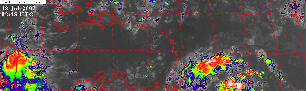
WOW!!!!!Da..Da...That sssstuffff coming off the African coast,I am not sure its a weather system,look more like a super-hydrogen bomb explosion!If thats a tropical wave,it would be the biggest one I see in 6-7 years!That stuff have a chance of becoming a Hurricane LUIS II (2).However,convection usually dissipate a little when it move off the coast.This disturbance need extra care.
On the Satellite image below,you can also see the tropical wave that move off the coast a couple of days earlier.Little banding feature or convection is noted and there is a ely shear on the system.But the shear is expected to decrease as the system moves westward and the disturbance could become better organize then.Also need to keep an eye on this one.
(The wave is located in center of the imagery)
 SAT>7
Heres another thats developing slowly,a spiral banding is noted indicating circulation.
Location(12.5N,50W)
 SAT>8
To the north,you can see the spiral feature of the remnant of Dean.
To the far west is a burst of convection.MASSIVE!,but........nothing of our concern in the east.
Have a nice day all... Get your FREE download of MSN Explorer at http://explorer.msn.com |
| - Update |
|
|
Weather is sunny in Antigua,not a single drop of rain.
This tropical wave south of the Cape Verde is poorly organize at this time.Convection is small and weak,but development is expected.
 SAT>6 Get your FREE download of MSN Explorer at http://explorer.msn.com |
| - Deans dead,whos next? |
|
|
We got a bright sunrise,weather is fine,lota blue skys.
Dean in the west has become disorganized a while ago and has downgraded to a tropical wave,redevelopment is unlikely.Storms this year seem to be forming after the disturbance pass the Eastern Caribbean Islands,and other than Chantal,all the others are short lived,two out of 4 storms move at unusual incredible speed.
The latest is a strong tropical wave moving off the African coast.Development is expected so we need to keep a look out.If it develope into a cyclone before longtitude 35W and move WNW or NW then it'll pass way to the north of the Leeward,but if it move west,watch out! Get your FREE download of MSN Explorer at http://explorer.msn.com |
| - Dean..... |
|
|
Weather is overcast with persistent moderate rain and thunderstorm occuring from around 12:00am this morning to 7:00am and partly cloudy sky and improving thereafter.And did we got some wind!Max winds speeds around 30-35mph gusting to 45mph at times,50mph winds are reported on higher terrain.Wind decrease gradually. Weather now at 10:30pm is fair.Winds at 16mph. Get your FREE download of MSN Explorer at http://explorer.msn.com |
| - TS DEAN!!! |
|
Phewww!!!! A few hours earlier and DEAN would have formed right over our heads! Based on its current track, "Happy Man" 's wife from the Turks may get her wish to film a storm in action. Be careful for what you wish for though.... The sun is shining brilliant through patches of clouds. Alan B. Scholl |
| - Passing Wave |
|
The sky is breaking and the sun is actually peeking out now with large pacthes of blue sky!!! There was some more rain earlier this afternoon but it has all subsided for now. Alan B. Scholl |
| - Overcast and grey! |
|
We awoke this morning to a very overcast and grey sky. There was some occasinal strong gusts early this morning and occasional heavy rain. On my way to work, it was starting to get heavy but has subsided since. Accoring to the reports, this wave is showing signs of development. I hope it develope AFTER it passes here, it would be interesting if it formed right over our heads :-) Alan B. Scholl |
| - Update | |
| |
|
| - Update | |
| |
|
| - Update |
|
|
Hi,everyone
At 4:00~5:00pm in St.John's the weather is partly cloudy to cloudy with some showers,wind at 15mph.
6:00~9:40pm,skys partly cloudy and drizzle.Wind at 13mph,Temperature/27.5degree C.
Now is 10:35pm,sky become partly overcast with light to moderate showers which cease as I write.The wind speed is 20-23mph gusting to 26mph ocassionally.
I guess there will be stronger winds and more bad weather coming up,maybe until 12:00 noon tomorrow.Seem as though Guadeloup getting the worst.
Wave still need monitoring. Get your FREE download of MSN Explorer at http://explorer.msn.com |
| - Update | |
| |
|
| - Overcast & raining in the outh |
|
Hi, It is about 2:00PM and some heay showers are being noticed in the south. Hopefully, this wave should continue to bless us with some more needed rain. Alan B. Scholl |
| - Update |
|
|
Patches of cloud drifting in form the ESE,otherwise weathers fine.Winds at 16knots.
Convection associate with Trop. Wave located 200mile east of the Lesser Antilles has increase during the past few hours,however, if the system don't become a depression by nightfall tonight,it will not until it past the islands.Even if it become one near the islands,it will not do much. Get your FREE download of MSN Explorer at http://explorer.msn.com |
| - Update | |
| |
|
| - Update |
|
|
<As anyone would notice,some of the sat. imagery posted by me below has automatically updated so they don't make any sense with the text discription and date.>
Weather is fine this morning but sky has become cloudy by nightfall.Winds at <15knots/17mph,we expect a few light showers tonight or tomorrow.Its real hot here,around 29degrees at 9:00pm.These influence is maybe due to clouds moving up from the Windwards where the ITCZ and a weak tropical wave is active.
If you scroll down,a look at the updated Satellite Imagery will so a tropical wave accompanied by a 1013mb low a little way off the Windward Islands located at about <14N53W> moving west at 15mph.This morning Sat. Imagery show the wave has wildly scattered convections which indicate disorganization.However,Sat. Imagery tonight show a more concentrate convection and a cyclonic turning is visible.We need to keep a look out.
post later>> Get your FREE download of MSN Explorer at http://explorer.msn.com |
| - Update |
|
|
Weather is super clear in Antigua.
That wave in the Atlantic<12N50W> is seemingly became disorganize. Get your FREE download of MSN Explorer at http://explorer.msn.com |
| - Another one? |
|
 They say this tropical wave is becoming better organize and development is anticipated.(But to me,this wave dosen't look organize,at least it does not seem to have a circulation)
Nevertherless,lets wait and see.
Report back later.bye Get your FREE download of MSN Explorer at http://explorer.msn.com |
| - Update | |
| |
|
| - would Chantal cripple a second time..? |
|
|
Breezy in Antigua,no rain,but a cloud is movin up..
 Convection Dosen't look too healthy.
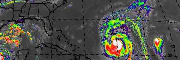
![[radar map]](http://www.intellicast.com/WeatherImages/CustomGraphic/hurtrack.wsi;hurtrac;CustomGraphic;gif;hutrack1.gif) Forecast track fo Chantal.
The system at 11:00am seem to become disorganized and weakens slightly, a single circulation split into two.
Get your FREE download of MSN Explorer at http://explorer.msn.com |
| - Update | |
| |
|
| - Regeneration.....Back to storm then to Hurricane! |
|
|
Now I know Chantal is not dead but only crippled as it pass the windward,but now,its back to destruction....
 4:15UTC 18,Aug 2001
By 3:00pm,it became a tropical storm and at 12:00midnight,its still strenghtening and heading West-West North West as the ridge to the north weakens. Its heading for Jamaica! Get your FREE download of MSN Explorer at http://explorer.msn.com |
| - Remnant> |
|
|
Last night,we got partly cloudy to cloudy sky with no rain but wind at 25-30mph gusting to 35mph,the climax came at 1:00am with light overcast to cloudy sky with light squalls and light thunderstorm,wind 30-35mph gusting to 45mph,this morning cloudy,winds 25-35mph. Get your FREE download of MSN Explorer at http://explorer.msn.com |
| - My Satellite |
|
The Satellite Pictures Martha is mentioning can be found on this website as well. When you go to the "My Satellite" page you can select your island, say Antigua, and you get a close-up satellite image centered on Antigua. Try it: http://stormcarib.com/mysat.htm Gert * ** *** Gert van Dijken ( gert AT vandijken.com ) **** Caribbean Hurricane Network - http://stormcarib.com/ |
| - TO GET SAT. PIC | |
| |
|
| - STORM CHANTAL GHCC - Interactive GOES-8 Infrared Satellite Data Selector | |
| |
Title: GHCC - Interactive GOES-8 Infrared Satellite Data Selector
|
| - cool!! :) | |
| |
|
| - STORM SCARE........ |
|
|
Oops!I think thats it for Chantal......too bad it don't have a funeral service.
The high pressure and a ridge is keeping it well south of Antigua.We got near 25knots/30mph wind since 11am and still getting the same strenght now(10:58pm).Not a drop of rain had fall over the past 10 hours,in fact,we only got cloud 2-3 hours ago. Get your FREE download of MSN Explorer at http://explorer.msn.com |
| - Update | |
| |
|
| - Current conditions.. |
|
It is quite windy here but this probably originates from the high pressure system in the Atlantic as it is more NE to ENE and pretty constant. Other than that the skies are hazy with patches of blue. The beaches on the NW (Fort James, Dickenson Bay etc) were not particularly rough but a bit more choppy than usual. Hope all is well with our neighbours to the south... Alan B. Scholl |
| - TROPICAL STORM CHANTAL |
|
|
Title: TROPICAL STORM CHANTAL
I'VE BEEN READING SOME OF THE UPDATES FROM THE ISLANDS THAT ARE BEING THREATENED AND IT SEEMS THAT THEY ARE NOT QUITE SURE WHAT TO DO. AFTER ALL, IT'S ONLY A TROPICAL STORM SO THERE IS NO NEED FOR A MAD PANIC. TAKE PRECAUTIONS AND IF YOU NEED HELP OR ADVICE ON WHAT TO DO THEN CALL US HERE IN ANTIGUA. WE HAVE LOTS OF EXPERIENCE WITH THE BIG ONES. Allan |
| - Break Time |
|
|
Seem as thought amature Chantal is gona hit windward flat in the face tonight.
Anyway,Antigua deserve a break after those powerful creature running across Antigua & Barbuda during the pass 6 years,its now the Windward islands turn to suffer(which I do not wish).Antiguans can sleep and work in peace.....at least FOR NOW.
Antigua is still having clouds and drizzle in part of the island but the sun is shining bright over St.John's.However,feeder bands from Chantal might affect the island soon,so we'll be back in the river.
If the storm pass above the 15degrees line(which is not likely), we might get some heavy gust,otherwise,we are safe. Get your FREE download of MSN Explorer at http://explorer.msn.com |
| - quite breezy | |
| |
|
| - TS Chantal !!! |
|
We had quite a bit of lightning and thunder last night from the end of the wave. I have not heard/FELT thunder like that in years. According to the latest reports, the depression has become TS Chantal!!! It has not deviated much so the southern islands should already be preparing for this one. Alan B. Scholl |
| - Update | |
| |
|
| - OFFICIAL REPORT | |
| |
|
| - Moving closer |
|
As of 11pm local Antigua time Weather Channel reports Tropical Storm watches polsted for Barbados, St. Vincent and St.Lucia New position 12.6N 50.2W 625 miles east of Barbados and moving atg 26 mph directly west Now within 36 hours of landfall and expected to be a hurricane south of Puerto Rico within 72 hours. Predicting Antigua will start seeing the way outer bands early Friday morning A good test of being prepared!!!!- cheers-rl |
| - Storm Bearing? |
|
|
TD4 continues to move rapidly due west,chance of hitting Antigua is almost nil~ The maximum line of passage would only reach as far north as Dominica,but a north shift would bring it closer(but still not to close).Guess all we are getting is rain especially since the convection area is to the north of the center,we got a higher chance of rain than those island to the south of the center.If the system slows down,it would had a better chance of strenghtening even more,but then,it might also had a higher chance of shifting north. We just need to keep on the look out. Bye~~ Get your FREE download of MSN Explorer at http://explorer.msn.com |
| - TOO CALM AROUND HERE!!! | |
| |
|
| - moving faster |
|
Dr.Steve Lyons at Weather Channel in 8pm Antigua time update reports TD4 moving faster westward than anticipated. Says the island chain will start feeling the northern winds of Chantal as early as tomorrow afternoon (THURSDAY) . Still on target for a Friday daytime arrival over the islands as a hurricane. cheers-rl |
| - The OFFICIAL version!! |
|
TROPICAL DEPRESSION MOVING RAPIDLY WESTWARD...HEADING FOR THE LESSER ANTILLES... ALL INTERESTS IN THE LESSER ANTILLES SHOULD MONITOR THE PROGRESS OF THIS SYSTEM. A TROPICAL STORM OR A HURRICANE WATCH MAY BE REQUIRED FOR PORTIONS OF THE LESSER ANTILLES AS EARLY AS TONIGHT. AT 5 PM AST...2100Z...THE POORLY DEFINED CENTER OF TROPICAL DEPRESSION FOUR WAS LOCATED NEAR LATITUDE 12.5 NORTH...LONGITUDE 47.2 WEST OR ABOUT 825 MILES...1330 KM...EAST OF THE WINDWARD ISLANDS. THE DEPRESSION IS MOVING TOWARD THE WEST 37 KM/HR AND THIS MOTION IS EXPECTED TO CONTINUE DURING THE NEXT DAY OR TWO. ON THIS TRACK...THE TROPICAL CYCLONE SHOULD BE APPROACHING THE LESSER ANTILLES IN A COUPLE OF DAYS. MAXIMUM SUSTAINED WINDS ARE NEAR 55 KM/HR...WITH HIGHER GUSTS. SOME STRENGTHENING IS FORECAST DURING THE NEXT 24 HOURS. ESTIMATED MINIMUM CENTRAL PRESSURE IS 1009 MB...29.80 INCHES. |
| - too early to tell??? | |
| |
|
| - TD$ 6pm Antigua time latest update |
|
TD4 now at 12.5N 47.2W -moving very quickly at 23-29mph with 35mph winds -825 miles E of Windward Islands .A hurricane watch or tropical storm watch may well be called this evening for several of the islands. The probability of landstrike as a Category 1 hurricane over area from Barbados to St Lucia if it continues on its direct westward path in 12 hour period Friday 12 noon onwards Antigua time versus only 12% probability if it jjogs northwest of affecting 65 mile area around Antigua. cheers-rl |
| - Update | |
| |
|
| - TD4 path |
|
Weather Channel at 3pm Antigua time produced first projected path of Chantal predicting over the islands at hurricane strength Friday night into Saturday morning. Fairly wide swath and unknown if it will be to the north the south or the center at this point. Still moving quite rapidly directly west. First hurricane reconnaisance flights into Chantal at 5pm Antigua time tomorrow (THURSDAY). Also a new "fairly bigorous" tropical wave just came off the African coast that will also need careful monitoring. Getting busy!!!-rl |
| - Jumby washing out |
|
Jumby Bay reporting heavy continuous rain is beginning to cause some minor flooding and washouts- grass is fully green again, palm trees reopening but mud is sliding. Workers there getting hurricane shutters readied. Fragile stuff being moved indoors already.-rl |
| - TD 4 threats increase |
|
At 1pm Antigua time Weather Channel says TD4 is moving faster than 23 -35mph westward and that by 12 noon Thursday it will have been upgraded to a Tropical Storm. Dr.John Hope fears it may well be at Hurricane strength as it approaches the islands as early as Friday. Thus Chantal will have arrived in the neighborhood and it doesn't look like a gentle French princess to me. Watch carefully- its quickness may surprise !!! Thats the real trouble with French women!! cheers-rl |
| - TD4 update |
|
as of 12 noon local Antigua time: Weather Channel says it is now officially Tropical Depression 4 at 12.3N and 45.) W 975 miles east of the Windward islands with 35mph winds moving West at 23 mph. Weather Channel also reports there will now be rain on Thursday for Antigua and for next seven days with exception of Sunday- I guess people can get to church dry! we'll keep watching -rl |
| - Update |
|
|
Got some rain here,otherwise,nothing much.
Dominica got a high chance of getting a strike from that Swirly. Get your FREE download of MSN Explorer at http://explorer.msn.com |
| - TD #4 |
|
HI ALL, Well #4 is on our doorstep. While the track has it south of us, we have to keep a keen eye on this storm!!! Alan B. Scholl |
| - TD about to form |
|
Weather Channel reports at 8pm local time that the storm cluster about 3-4 days out will probably become a Tropical Depression in 24 hours and is worth watching carefully. Weather Channel also projecting rainfall over Antigua for next seven days but none on Thursday. Congrats to Martha on her remarkable Arctic Seal save- now we must all gird together to do battle against Dolphin Captivity Program. Great that so many Antiguans came together yesterday to save an injured mammal - now we have to save the live healthy ones before they are injured by agressive hunters. Cheers! |
| - IS IT WEATHER RELATED!? | |
| |
|
| - Update |
|
|
Got some new update,guess i am right,as the High Pressure weakens,the Atlantic has become relatively active.Watch out people!!! Get your FREE download of MSN Explorer at http://explorer.msn.com |
| - Update |
|
|
Guess we are going to get some rain today.
The tropical wave located in the central Atlantic has become better organise as the High Pressure rich to the north weakens. Get your FREE download of MSN Explorer at http://explorer.msn.com |
| - Update | |
| |
|
| - Storm cluster just east of us? |
|
I have been watching the mass of clouds slowly approaching the Eastern Caribbean. While there are no reports of development, we probably will be in for some serious thunderstorm activity. Any comments on this? Alan B. Scholl |
| - Update |
|
|
We got some nice rain this morning,feel refresh
That tropical wave in the central Atlantic is showing some sign of organization.But even if it became a tropical cyclone,the high pressure will cause a shear on the system and cause it to weaken or a stop in strenghtening.If the high pressure only weaken.................... Get your FREE download of MSN Explorer at http://explorer.msn.com |
| - Update |
|
|
Strengthening High Pressure systems continues to dominate all of Central & North Atlantic No development is anticipated with any of the disturbance. Get your FREE download of MSN Explorer at http://explorer.msn.com |
| - Update |
|
|
With this type of strong high pressure dominating the Atlantic,those tiny disturbance moving off Africa wouldn't go very far in development (if there's any).But I noted some slight weakening in the High Pressure system,dropping from 1030mb to 1028mb,but thats still to high for much development,In fact,a 1026mb High is moving south next to the one thats already there.However,in my opinion,both system will weaken sooner or later.
Get your FREE download of MSN Explorer at http://explorer.msn.com |
| - Update | |
| |
|
| - Update |
|
|
Very dry ........and hot, i see something is in the eastern Atlantic Get your FREE download of MSN Explorer at http://explorer.msn.com |
| - Update |
|
|
Hope we are not back into the wave of drought,its stinking hot here! MY OUT LOOK>> -> SST(Sea Surface Temperature) in the Centra & Eastern Atlantic is presently not warm enough for development this early in August but its getting there. -> High Pressure System prone to cause vertical shear in cyclone,therefore weakens them or make developing disturbance become disorganise.There is a STRONG High Pressure Rich in the central -north Atlantic and another one in the Gulf of Mexico now,making development impossible.However,if only these High Pressure retreat north,weaken or dissipate altogether then I believe development is climatologically anticipated. So....pray that it don't! Get your FREE download of MSN Explorer at http://explorer.msn.com |
| - Update | |
| |
|
| - Update |
|
|
A weak wave is passing,weathers fine except some light showers. Lets try my little prediction. I am not an expert but i know what I am saying, I smell somethings up with the Atlantic,every time theres a long span of minimal activity period(which can be said as the 'incubation' period) somethings always up.
Get your FREE download of MSN Explorer at http://explorer.msn.com |
| - Update |
|
|
Well.....,its pretty quite now,no storm ,no depression but still on guard. Get your FREE download of MSN Explorer at http://explorer.msn.com |
| - Update | |
| |
|
| - East Atlantic IR Ch. 4 Loop | |
| |
|
| - Update | |
| |
|
| - Update | |
| |
|
| - Update | |
| |
|
| - Update | |
| |
|
| - joining the report team |
|
have decided to join Antigua's intrepid team of weather watchers- and hope to add some pithy contributions in the future. Meantime Keep Antigua Shining.Cheers-rl |
| - Update | |
| |
|
| - Update | |
| |
|
| - TD #2 |
|
Hi,

Well our first "swirly" is lining us up in the crosshairs. The track is
taking it pretty close to Antigua/Barbuda. Although it is a bit early to
worry, there is nothing wrong with a little mental preparation.

Alan B. Scholl
Email: scholla AT candw.ag  alan.scholl AT cw.com
       schollab AT hotmail.com     schollab AT yahoo.com
|
| - FIRST TROPICAL STORM WARNINGS ISSUED... | |
| |
|
| - Update | |
| |
|
| - Update | |
| |
|
| - test report to HURRICANE REPORT PAGE | |
| |
|
| - Update | |
| |
|
| - Update |
|
|
2 drops--------back to the
sahara.
|
| - Update |
|
|
This system coming up from the southeast is the
FIRST promise of rain (also the first wave) we have had this year! I don't
recall a drier year.
p.s. ocean getting quite
warm.
|
| Back to top |
