![[IMG: Luis; Credit: Norm Nelson, Bermuda Biological Station for Research - http://www.bbsr.edu/Weather/]](luis5.gif)
|
The Caribbean Hurricane PageUpdates from the Islands
|
Archive of weather discussions and eye witness reports from the Caribbean Islands in the 1999 Atlantic Hurricane Season. Featured on this page: Jose, Katrina and Lenny. Other 1999 storms can be found on another page. For current events look here.
| - - - Lenny - - - |
Pleas for Help can now be posted on our bulletin board
Local Updates from the islands can be found above, including St.Maarten/St.Martin, Anguilla, St.Croix, Antigua and many others...
[Sat, 20 November 1999 14:15 EST] - Really Gone!
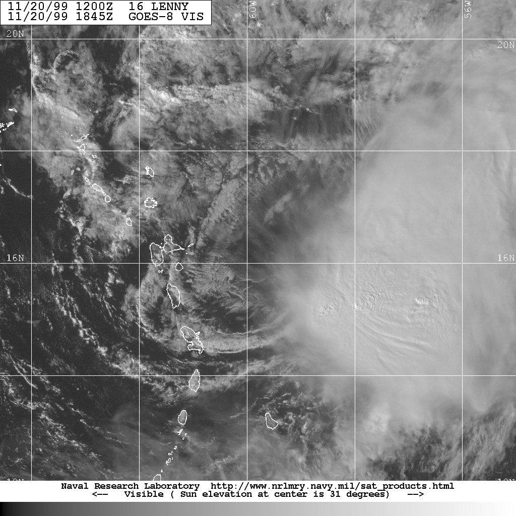
Tropical Storm Lenny is now located about 145 miles east southeast of Antigua. Satellite images show that the areas of convection are located well east of the islands right now and that the sun is out (see here, source: NRL Monterey). So it's really over now! Let the cleanup begin!!! Local reports by our special hurricane correspondents can be found above.
[Fri, 19 November 1999 20:55 EST] - Tropical Storm Lenny
Lenny is downgraded to a tropical storm now. Winds are not the problem anymore, but looking at the satellite images there is still a lot of convection close to Antigua and Guadeloupe. The 'center' is located about 20 miles northwest of Antigua. Reports from Antigua indicate a lot of rain (over 25 inches since Wednesday!), but not too much wind (see above). The system is slowly driftin eastward, so hope it over for everyone soon. I am tired...
[Fri, 19 November 1999 14:15 EST] - Weakening more
Lenny is weakening more. Barely a hurricane now with maximum sustained winds of 70mph. According to the National Hurricane Center the center is located between Antigua and St.Kitts. However, if I look at satellit images it seems that the center is much more to the east, just northeast of Antigua... Rain has been a major problem on the islands. Right now, looking at infra-red images, most convection is to the east of Antigua and Barbuda. It looks like Barbuda will get some more torrential downpours, but for the other islands, it should be almost over. Finally! This is one weird hurricane!
[Fri, 19 November 1999 12:55 EST] - St.Maarten/St.Martin
From all the reports we are seeing from St.Maarten/St.Martin the situation seems to be as follows:
- Wind damage not that bad (at least compared to Luis)
- Most problem areas are the lower lying areas on the waterfront on the south side of the island. Philipsburg, Simpson Bay, Pelican, Beacon Hill, due to the massive waves
- Telephone on the Dutch side seems to work here and there. Electricity poles are mostly up as well.
- The road to the airport has probably suffered a lot of damage
- The condition of the airport is unknown, some say it has been badly damaged, others say it is not that bad
Please, everyone keep your common sense. I haven't heard any confirmed reports of fatalities other than rumours. A lot of misinformation is going around. Above you find links to our news-updates for each island. Unfortunately I don't get much news from St.Barts and Saba. Reports from my hurricane correspondent on Anguilla are still coming in! More news can be found on our Pleas for help Bulleting Board.
[Fri, 19 November 1999 10:10 EST] - Still there but getting better!
Lenny is still meandering around Anguilla, St.Maarten/St.Martin and St.Barts. Then moving a bit east, then southeast, west, etc.etc. Right now maximum sustained winds are 90 mph and it is expected to further weaken. So it has quieted down a bit on the islands. But steering winds are still weak, though the Hurricane Center expect Lenny to move out of the area within 12 hours.
Some phones are still working on St.Maarten/St.Martin. First reports indicate that on St.Maarten/St.Martin esp. the Simpson Bay area was hit hard. Will update more when news comes in. Just remember, that this is the time that rumours go around the island. Not everything you read here might be true! Links to local updates from the islands above. Also, tid-bits of information is also posted by several people on our Pleas for Help Bulletin Board.
[Thu, 18 November 1999 16:45 EST] - Weakening
The center of Lenny is still lingering just west-southwest of St.Maarten/St.Martin. Or better (worse) part of the eye is probably over St.Maarten. The winds before the center drifted to St.Maarten were not too bad (see my earlier SXM-update, which I think is strange, because this was supposed to be a 135 mph hurricane... Right now winds are down to 120mph, this is from a recon-flight. Also, pressure is up to 966mbar, another sign of weakening. BUT it is unfortunately still a Cat-3 hurricane. Lenny is expected to keep drifting around this area, due to lack of steering currents, for the next 12 hours... I hope not of course. Anyway, it looks like St.Maarten/St.Martin did more or less 'ok' during the first part. With the weakening of this storm the second part will windwise not be as bad. Torrential rain and battering waves will undoubtedly stay a problem though. Links to updates from the islands by our hurricane correspondents are posted above. Also, I am very busy here trying to coordinate things and keep this website running under the high load so I am not able to answer any e-mail regarding the current situation and/or lost contacts. Pleae, use our Pleas for Help Bulletin Board for this purpose. If you do have any news which you think might be useful for other people as well forward it to me at gert@gobeach.com. Thanks.
[Thu, 18 November 1999 12:15 EST] - St.Maarten
The center of Lenny is now very, very close to St.Maarten/St.Martin. Weather conditions at Juliana Airport, St.Maarten as of 11:36 EST: Wind from the SE (130 degrees) at 55 MPH (48 KT) gusting to 80 MPH (70 KT). That's not bad at all, not even hurricane force winds. Weird since the center is so close to the islands... Suprised though that we still get weather reports from St.Maarten (URL: http://tgsv7.nws.noaa.gov/weather/current/TNCM.html. Links to weather reports from other islands can be found on our 'Practical Guide'
[Thu, 18 November 1999 10:36 EST] - Move!!!
Lenny hasn't moved much over the last 12 hours. The center is located at 17.8N, 63.6W or about 20-25 miles east-northeast of Saba, 35 miles west-southwest of St.Maarten/St.Martin and about 40 miles west-southwest of Anguilla. The good thing is that winds are down a little to 135mph, which makes it borderline Cat-3/Cat-4 hurricane, so still a major one. It isn't expect to move much in the next 12 hours, hopefully after that steering currents will take it away quickly. The most recent forecast shows that the center of the storm will pass over Anguilla, but regardless, it is a bad situation for Anguilla/St.Maarten/St.Martin/Saba/Statia already. Waves have been a problem already, and with this storm sitting at the same spot, swells can keep growing... The only positive thing is that the longer it sits in the same spot the colder the water gets and the weaker the storm gets. But apparently that process is quite slow since it already hasn't moved much over the last 18 hours... It is expected to move over Anguilla in about 18 (!) hours, so the islands will continue to see hurricane force winds for a while...
Anyway, let's just hope for the best. Local reports above.
[Wed, 17 November 1999 22:36 EST] - Stalled!
Lenny keeps surprising us! Make you wonder what we really know about hurricane forecasting. We knew it was hard to predict intensity changes, but no-one would have predicted that Lenny would stop moving forward!
I am not sure if this is good or bad. At least maximum sustained winds are down a little (145mph). Also, since it is sitting at the same spot it will mix up the ocean and bring up colder water. Warm water is the energy source for a hurricane, so stalling means weakening (most of the time...). On the other hand, winds will keep blowing out of the same direction over large areas, promoting buildup of huge swells. I have heard reports of damaging waves on St.Maarten and many other islands. This will get worse the longer our friend sits there...
In any case, I am relieved to see the reports from St.Croix and to note how little damage they seem to have sustained. This while this 150mph beast was sitting at their doorstep...
Now it looks to be another 12 hours before Lenny's eye makes its closest point of approach to St.Maarten/St.Martin/Anguilla. Well, at least the new forecast brings the eye a little further from Anguilla for a change, instead of closer! Also, for Saba it is still not looking too good, but well, maybe just a little better. Let just hope that Lenny weakens even further and will pass the island chain just between the BVI and Anguilla to cause as little damage as possible...
Again, links to our local reports from the islands can be found above. If you are trying to get in contact with people you can use our bulletin board.
[Wed, 17 November 1999 17:20 EST] - Heading towards Anguilla/St.Maarten/St.Martin
The latest: Lenny hasn't strengthened even more. It is just southeast of St.Croix and about 85 miles west, southwest of St.Maarten. Currently hurricane force winds extend to up to 55-60 miles to the northeast of the center. With a current forward speed of 9 mph, this means that St.Maarten/St.Martin can expect hurricane force winds in (85-60)/9 = almost 3 hours... The eye will make its closest point of approach in about 9.5 hours...
From the latest advisory:
AT 5 PM AST...2100Z...THE EYE OF HURRICANE LENNY WAS LOCATED NEAR
LATITUDE 17.6 NORTH...LONGITUDE  64.3 WEST OR ABOUT 35 MILES...55
KM...EAST-SOUTHEAST OF ST. CROIX OR 85 MILES...135 KM WEST-SOUTHWEST
OF ST. MAARTEN.

LENNY IS MOVING TOWARD THE NORTHEAST NEAR 9 MPH...15 KM/HR.  ON THIS
TRACK...THE CORE OF POWERFUL HURRICANE LENNY WILL BE CROSSING THE
WARNING AREA LATER TODAY.  WEATHER CONDITIONS WILL CONTINUE TO
WORSEN IN THE AREA.

MAXIMUM SUSTAINED WINDS ARE NEAR 150 MPH...240 KM/HR...WITH HIGHER
GUSTS ESPECIALLY OVER UNPROTECTED SOUTH AND WEST FACING HARBORS.
LENNY IS VERY CLOSE TO BEING A CATEGORY 5 HURRICANE ON THE
SAFFIR/SIMPSON HURRICANE SCALE.  STRONGER WINDS COULD BE EXPERIENCED
IN MOUNTAINOUS AREAS.  SOME FLUCTUATIONS IN INTENSITY ARE EXPECTED
DURING THE NEXT 24 HOURS.

HURRICANE FORCE WINDS EXTEND OUTWARD UP TO  70 MILES...110 KM...
FROM THE CENTER...AND TROPICAL STORM FORCE WINDS EXTEND OUTWARD UP
TO 205 MILES...335 KM.  THERE ARE REPORTS FROM SABA OF GUSTS TO 60
MPH...97 KPH.

MINIMUM CENTRAL PRESSURE MEASURED BY A RECONNAISSANCE AIRCRAFT WAS
934 MB...27.58 INCHES.

RAINFALL TOTALS OF 10 TO 15 INCHES...WITH LOCALLY HIGHER AMOUNTS IN
MOUNTAINOUS REGIONS ARE ASSOCIATED WITH THE HURRICANE.  THESE RAINS
CAN PRODUCE LIFE-THREATENING FLASH FLOODS AND MUD SLIDES.  SAN JUAN
DOPPLER RADAR SHOWS HEAVY RAINS CONTINUING TO SPREAD OVER PORTIONS
OF PUERTO RICO...THE VIRGIN ISLANDS...AND THE NORTHERN LEEWARD
ISLANDS.

ISOLATED TORNADOES ARE POSSIBLE OVER THE WARNING AREA.

STORM SURGE FLOODING OF 5 TO 8 FT ABOVE NORMAL...ACCOMPANIED BY
LARGE AND DANGEROUS BATTERING WAVES...IS EXPECTED NEAR THE CENTER IN
THE WARNED AREA.
[Wed, 17 November 1999 14:05 EST] - ...!!!
3PM AST Update... Maximum sustained winds near ONE HUNDRED AND FIFTY MILES. Well, at least the minimum central pressure went up a little to 936mbar. Northern eyewall just south of St.Croix. Lenny moving towards NE near 12mph. Current location for people who still dare to plot it: 17.5N, 64.7W. Lenny is now almost a Category 5 (the highest) Hurricane. No, I am not going to mention that other L-hurricane.
On the 'plus' side, it is hard for a hurricane to keep this kind of strength. On visible satellite images it looks like the eye is not as clear anymore, but seems to fill in with clouds a little. A sign of weakening. But this might be wishful thinking from my part. See eg: here (from NRL Monterey).
[Wed, 17 November 1999 13:10 EST] - ...
1PM update... I don't even want to see it anymore, but 140mph! Min. central pressure 933mbar!! Now at 17.2N, 64.8W, or about 35 miles south of St.Croix...
[Wed, 17 November 1999 10:10 EST] - Cat-4
It does not look good. Lenny has done the unexpected again. It has strengthened into a Category 4 Hurricane. Maximum susstained winds are near 135mph and the minimum central pressure is a whopping low of 942mbar! For what it is worth, the National Hurricane Center does not think that this Lenny-thing, Lefty Lenny, Backdoor Lenny, or what ever you want to call it,will strengthen even more.
The track: currently the eye of Lenny is at 17.1N, 65.1W. For people who track it, YES, more to the east again. Again, as stated below, good for the people 'above' the track, bad for the people south of it, even worse when you take into account that the strongest side of the storm is on the southeast side.
As it stands right now (subject to change of course) Lenny's eye will not go over St.Croix, but will stay just east of it (about 20 miles). The center is located less then 50 miles from the island right now! The latest reports from St.Croix show that they still have power.
For the rest of the USVI and BVI it is looking a little better too, but a little better from very bad is still quite bad. The center might stay as far as 50 miles from the BVI! Above you can find local reports straight from the islands.
For Saba, Statia, and especially Anguilla and St.Maarten/St.Martin it looks bad. Right now the eye will pass Anguilla as close as 25 miles, St.Maarten/St.Martin 35miles. But because the forecasts tend to shift to the west with every new advisory I would not be surprised if the eye will make landfall there. Regardless, it's a huge system. As the Hurricane Center repeats over and over again, don't focus on the eye too much. It will be bad. Closest point of approach for St.Maarten/Anguilla will be in about 18 hours. Yes, the forward motion has slowed down somewhat. Now 13 mph. With hurricane force winds extending up to 55-60 miles from the center, and tropical force winds advancing the storm 145 miles, there will be no escape. In addition to the winds, the torrential rains will cause flooding and muslides... People in this area HATE L-storms...
Stay tuned with what is happening on the islands. We are still getting in reports by our special hurricane correspondents (see above for a listing of all islands).
[Wed, 17 November 1999 0:05 EST] - Moving more northward...
Lenny has become better organized. With max.sustained winds near 115mph Lenny is now classified as a Category-3 hurricane. The 10PM advisories show that Lenny's forward motion finally has a more northernly component, actually it is moving more or less due northeast now. I cannot say if that is good news or bad news. Depends on where you live. Since it started moving in this direction so late Lenny's center will stay further from Puerto Rico than earlier thought. Also, since the strongest side of the storm is to the southeast of the center (away from Puerto Rico) this is more good news for them. For the more northeasternly Leeward Islands (Anguilla, St.Maarten/St.Martin, Saba, Statia, St.Kitts, Nevis, Antigua, etc.) this is bad news. They will be on the strong side of the storm.
Using the 10PM advisories the center of Lenny will pass by the island as follows: Puerto Rico: closest point of approach 70 miles in about 12 hours; St.Croix, sorry, 0 miles, 14 hours; St.John, Tortola, Virgin Gorda, Anagada: around 30 miles in about 18 hours; St.Thomas: 45 miles; Anguilla, St.Maarten/St.Martin: 50 miles, 22 hours; Saba: 70 miles; St.Kitts&Nevis: 110-120miles; Antigua: 160 miles.
Note that I stress the center above. Since this is a big storm and since this track is as we have noticed many times in not etched in stone, we shouldn't pay too much attention to where the center exactly is. Hurricane force winds extend to up to 55 miles from the center; 50 knot winds up to about 85 miles and tropical storm force winds (34kt) up to 175 miles from the center. So many islands will experience hurricane force winds... Also, looking at infra red images of Lenny you will see that the rain will be a huge factor as well... This is not a nice surprise so late in the season!!! See above for local reports from the islands by our special hurricane correspondents.
And new coordinates just came in. The 1AM (AST) location is 16.3N, 66.7W. So Lenny is wobbling a little more to the east again... Also, this is already a little east of the 3 day forecast track issued 3 hours ago. Good for the islands northwest of the forecasted track, bad for the ones below it... Too bad that the people of the NRL Satellite Team do not seem to update their tracks 'at night'. Their tracking charts are the best!
[Tue, 16 November 1999 11:35 EST] - Getting organized
Well, Lenny is stronger again, maximum sustained winds are now near 100mph. Also, it is expected to move a little more to the east than thought yesterday, resulting in tropical storm warnings for the more easternly islands (Dutch St.Maarten, Statia, Saba, Anguilla, Nevis, St.Kitts, Montserrat, Barbuda and Antigua). On its current forecasted track it will cross the island chain just east of Puerto Rico, and possibly make landfal in the USVI (St.Thomas/St.John) and BVI... So its looking a little better for Hispaniola, but worse for the more easternly islands. Eastern part of Puerto Rico, BVI and USVI will experience hurricane force winds, and if it takes a more easternly path, Anguilla, St.Maarten, Saba and Statia as well.By the time it reaches the islands (in about 24 hours) maximum sustained winds are expected to be near 110mph, a strong Category-2 Hurricane, which the islands, with good preparations should be able to handle. But again, the rain aassociated with this system might cause more trouble. Above you can find links to local reports from the islands by our special hurricane correspondents.
[Mon, 15 November 1999 23:30 EST] - Falling apart?
Lenny has weakened considerably since this morning. Satellite images do not show a very well organized hurricane either. Maximum sustained winds are now estimated to be near 80mph. Currently the 'center' of Lenny is located about 315 miles southwest of Santa Domingo, Dominican Republic. It is still moving east near 14 mph. Lenny is forecasted to be steered more to the north pretty soon. As it looks right now it will follow a little more westernly track than thought this morning. On this track the center of Lenny will move through the middle part of Puerto Rico with 90mph in about 36 hours. Hurricane warnings have therefore been issued for Puerto Rico and the Virgin Islands.
Although a little strengthening is forecasted, to me it looks like it will further weaken. The different model forecasts agree pretty well qua track. In any case, again, wind will not be the biggest factor. Sattelite pictures show that there is a lot of rain associated with this rather large system. Although Lenny won't make landfall in the Dominican Republic and Haiti, torrential rains will still be expected in the next 36 hours. Esp. in the mountainous terrain Hispaniola this will cause flooding and possible mudslides. For Puerto Rico the same, expect a lot of rain causing flooding and mudslides...
Pretty strange an eastward moving hurricane towards the northeastern islands this late in the season. So once more, hopefully for the last time this season, people have to get ready for this storm. Stay tuned with what is really happening on the islands. Check out the local reports from the islands by our special hurricane correspondents above.
[Mon, 15 November 1999 12:30 EST] - Lenny
And all of a sudden, we have a hurricane out there about 200 miles south of Jamaica packing 100mph winds! Saturday the first advisories were issued for tropical depression 16, Sunday it was upgraded to a tropical storm, and quickly thereafter to a hurricane!
It moved just south of Jamaica to the east, yes, towards the northeastern islands! Right now the eye is expected to skirt the east coast of Puerto Rico, and move just north of the USVI and BVI in a little over 48 hours! Maximum sustained winds at that time are forecasted to reach 110 mph...
Above local updates by our hurricane correspondents can be found. More discussion about the track later today.
| - - - Katrina - - - |
[Fri, 29 October 1999 17:05 EDT] - Katrina
A week after Jose we have a new tropical storm. Tropical Depression 15 was just upgraded to Tropical Storm Katrina. It is currently very close to the coast of Nicaragua, and is expected to make landfall later this evening, so it will be a short lived storm. There is some possibility however that it will re-emerge over water and restrengthen into a tropical storm again. Again, winds won't be the biggest problem. Like Jose this system will cause torrential rainfall, flash floods and mudslides will be very likely, esp. in the mountainous areas of Nicargua and Honduras. We haven't forgotten Mitch...
| - - - Jose - - - |
Trying to make contact with someone on the islands?
You can now post your 'Plea for Help' on our bulletin board
Look above for numerous local updates from the islands by our special hurricane correspondents
[Fri, 22 October 1999 19:00 EDT] - Stop the Rain!
Looking at the latest Forecast Track it looks like Bermuda will be spared by Jose. Great!
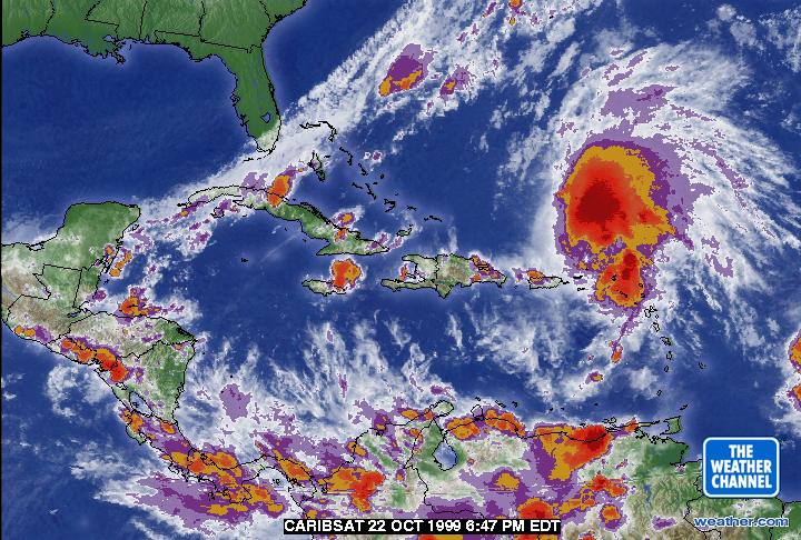
On the other hand, it's still raining really hard on the NE Islands. One of our special hurricane correspondents on St.Maarten/St.Martin reported that their was a casualty due to a landslide caused by the torrential rains from a feeder band of Jose (see for example this satellite image [source Weather Channel]). Hope it will stop soon so that the real cleanup can start.
[Fri, 22 October 1999 00:40 EDT] - It's over...
Well, is it? Weather reports and satellite images show that there is still a lot of rain hanging around the islands. But at least the wind is gone. A fair conclusion would be that Jose's path was quite unpredictable, but given the relatively short time that the islands could prepare for the storm they battered it really well. Though especially on Antigua they didn't expect Jose to be that bad (if you consider they had much worse...), but everything will be cleaned up quite quickly and be back to business as usual.
Only one thing to keep an eye on... Bermuda! There is a chance that it will pass close to this island. Though Jose is quite weak now it might restrengthen a little bit and become a hurricane again.
Also, a lot of people on the islands are talking that the next hurricane is already on its way. Don't worry too much about it. Yes, there is an area of disturbed weather about 500 miles west of the islands, quite far south. But it's not a hurricane, tropical storm or even a depression!
Finally, for the books, last night I quickly saved some neat satellite pictures when Jose was over the NE islands. The first one is from the 'NOAA/defiant' website, and the second one (237K) from the University of Hawaii Tropical Meteorology website, who always nicely focus in and enhance images with color and wind data (if available). And now that I have a little more time to browse around on the web to look at other website, the NRL Monterey Tropical Cyclone Homepage is really great for tracking maps and enhanced images.
[Thu, 21 October 1999 10:50 EDT] - Tropical Storm Jose
It's almost over. Jose has weakened considerably and is now downgraded to a tropical storm. The center is now located just north of St.Thomas. So Jose made the expected turn later then forecasted. It's track shows even that it seemed to make a special effort to turn just a little south to include Virgin Gorda and Tortola in it's path.
In any case, the good news is that all islands seem to have weather out the storm ok. Unlike it looked like yesterday the eye did indeed go over St.Maarten/St.Martin. Some parts of the island have and telephone and electricity, others have none. But the general feeling is that everything will be back to normal. Club Orient who out of a precaution evacuated their guests is back in business and has faxed (!) us even an update on the current situation. I also got through to my sister-in-law, who was sleeping... Her husband said that it didn't look too bad, a few boats stranded, some damage to vegetation, but nothing major as far as he knows. Now let's wait for reports from the other islands (see above by our special hurricane correspondents. Just received a live report from St.Thomas who are now 'in' the storm.
[Wed, 20 October 1999 23:45 EDT] - St.Maarten/St.Martin!
The center of Jose is now very, very close to St.Maarten/St.Martin (SXM). The eye is at 17.8N, 63.0W, SXM's coordinates are 18.0N, 63.0W, only .2 degrees. The eye is about 23 miles in diameter, so should touch SXM. However, I just spoke to my sister in law ([cell] phones are still working) who lives at Port de Plaisance, Cole Bay, and according to her it was still very windy, no eye. She could look over Simpson Bay Lagoon and noticed that there were already a couple of boats stranded. In any case, the eye will then pass just south of the island. I am afraid that since the island will be to the west of the storm (the strongest side) that they will experience 100mph winds. This is somewhat stronger than Bertha 2 years ago, from which the island recovered very fast, but of course a lot weaker than Luis in 1995. St.Barts and Anguilla will experience the same kind of winds as SXM I'm afraid. Unfortunately I haven't heard yet from my special hurricane correspondents from there. The good news is that Montserrate, Nevis, St.Kitts, Statia and Saba stayed on the weaker side of the storm.
And next...? Everybody is saying that it will turn more to the north, but it hasn't done so yet. But let's just trust those models (though they haven't been performing that well, remember that we first thought that Jose would pass over the Grenadines, about 500 miles to the south...?). Anyway, according to the 3 day forecast by the TPC/NHC, Jose is expected to pass over or north of the most eastern Virgin Islands; Anagada and Virgin Gorda. Again, many islands are closeby; Tortola, St.John, St.Thomas and also Puerto Rico, a little jog to the west, or a less then anticipated turn to the north could differ a lot.
Not much more to tell. Only that at least on Antigua it was worse than I and many others expected. Hopefully SXM and surrounding islands will do fine. We will know soon since Jose is still moving along fine; it will be over fast. Reports from the islands by the special hurricane correspondents are still coming in. See above for the listing. Also, if you are worried about someone on the island, you can now post your plea for help on our bulletin board.
[Wed, 20 October 1999 13:10 EDT] - Eye over Antigua
HURRICANE JOSE TROPICAL CYCLONE UPDATE
NATIONAL WEATHER SERVICE MIAMI FL
1215 PM EDT WED OCT 20 1999

THE DIRECTOR OF THE METEOROLOGICAL SERVICE IN ANTIGUA RELAYED A
RECENT WIND MEASUREMENT OF A GUST TO 102 MPH...164 KPH.  THE EYE OF
THE HURRICANE IS MOVING OVER THE ISLAND AT THIS TIME.  PEOPLE
EXPERIENCING THE CALM EYE OF THIS HURRICANE SHOULD REMAIN INDOORS AS
CONDITIONS AGAIN RAPIDLY DETERIORATE.

AVILA
[Wed, 20 October 1999 11:20 EDT] - Antigua!
Computer models.... Yesterday they seemed to be in close agreement that the center would pass over Guadeloupe in half a day. Now, 12 hours later the center is located just (about 15 miles) east (yes east, not west) of Antigua. So unlike yesterday the storm will pass North of Nevis, St.Kitts, Statia and Saba, but as it looks right now, right over St.Barts, St.Maarten/St.Martin and Anguilla! Since the trough north of the islands is weaker than expected (which already caused the more northernly track), the storm might go even further north than is forecasted, so the center might well pass north east of St.Barts, St.Maarten/St.Martin and Anguilla. The strongest side of the storm is the eastern side. That will now point away from the islands. Good for the islands above, but bad for Barbuda....
What to expect... Antigua should now be experiencing minimal hurricane force winds. Tropical storm winds are preceding the center by about 115 miles, ie., they are now very close to St.Barts and St.Maarten/St.Martin. Now maximum sustained winds are near 90 mph, it is expected to increase to 105 mph in the next 12 hours (about the time that the center is over St.Barts). So it will have reached Category-2 status by then. In short, windwise this is by now means an extremely dangerous hurricane (see windfield and definition below). But the rains will be a problem. Luckily it is moving along at 12mph, so it should be over fast.
Windfield (an explanation on how to read these things can be found in our Practical Guide):
Now:
     ESTIMATED MINIMUM CENTRAL PRESSURE  978 MB
     EYE DIAMETER  30 NM
     MAX SUSTAINED WINDS  85 KT WITH GUSTS TO 105 KT
     64 KT....... 30NE  20SE   0SW   0NW
     50 KT....... 50NE  50SE  20SW  30NW
     34 KT.......100NE 100SE  30SW  75NW
     12 FT SEAS..125NE 125SE  30SW 100NW
     ALL QUADRANT RADII IN NAUTICAL MILES
Antigua is to the west of the storm, so I take back what I said above, no hurricane force (64kt) winds for Antigua (although gusts will reach hurricane force easily). Tropical storm winds (higher than 34 kt) are inevitable of course.
In 12 hours (when it is expected to be over St.Barts and close to SXM):
     FORECAST VALID 21/0000Z 17.9N  62.8W
     MAX WIND  90 KT...GUSTS 110 KT
     64 KT... 30NE  20SE   0SW   0NW
     50 KT... 50NE  50SE  20SW  30NW
     34 KT...100NE 100SE  30SW  75NW
Again, only to the east of the eye, hurricane force winds, and with the tendency of this storm to go more northward than expected, it might be that even these islands might not see (sustained) hurricane force winds. But it will be a close call. Keep in mind that the exact track can not be forecasted exactly.
   Category Two - A Moderate Hurricane
          Winds: 96-110 mph, 84-96 kts, 154-177 km/h
          Minimum surface pressure: 979-965 mbar
          Storm surge: 6-8 ft, 1.8-2.6 m
          Considerable damage to shrubbery and tree foliage; some trees
          blown down. Major damage to exposed mobile homes. Extensive
          damage to poorly constructed signs. Some damage to roofing
          materials of buildings; some window and door damage. No major
          damage to buildings. Coast roads and low-lying escape routes
          inland cut by rising water 2 to 4 hours before arrival of
          hurricane center. Considerable damage to piers. Marinas
          flooded. Small craft in unprotected anchorages torn from
          moorings. Evacuation of some shoreline residences and low-lying
          areas required. Example: Hurricane Bob (1991)
[Tue, 19 October 1999 23:20 EDT] - Where oh where...
I am starting to repeat myself... The Tropical Prediction Center new 3 day forecast shows that Jose's track is a little more to the north then earlier. Not good, since now more islands are 'in the way'. Guadeloupe seems to be a sure bet. Then the center is expected to pass just north of Montserrat, then straight over Nevis, St.Kitts, Statia and Saba...
Maximum sustained winds are now near 80 mph, Jose's center is located at 15.9N, 60.0W or about 105 miles east south-east of Guadeloupe. As stated above there is a little more northernly component in it's west northwesternly motion. Currently the system is cruising along at 13 mph.
So what to expect...? The 'grunt' of the storm is on the east northeastern side, ie. the 'islands' side. In less then 12 hours the center will already be past Guadeloupe, in 24 hours past Saba. So the good thing is that it doesn't hang around; it will be over soon. Believe it or not but Jose is still a pretty weak hurricane. Hurricane force winds extend at this time barely 25 miles to the northeast of the center (and according to the Marine Advisory 0 miles to the other directions). Tropical storm winds however extend to up to 115 miles to the north and southeast and about 85 to the northwest and just 35 miles to the southwest. Keeping in mind that Jose is currently 105 miles from Guadeloupe and that tropical storm winds extend to up to 85 miles in that direction, which is just 20 miles away, and knowing that the current speed is 13 mph, we can see that Guadeloupe will experience tropical storm winds within TWO hours.
Between the time that it has passed Guadeloupe and is passed Saba (12-24 hours) winds are expected to have increased to about 92 mph. So still a Cat-1 Hurricane. But Guadeloupe may take a small toll on the hurricane's strength as well... Anyway, in 24 hours hurricane winds are expected to extend up to 35 miles from the center. Right now it looks like the center will pass about 20-30 miles south of Antigua, well within reach of hurricane force winds, and about 30-40 miles south of St.Barts, St.Maarten/St.Martin and Anguilla, so borderline hurricane force winds.
After that it is expected to pass over the over the Virgin Islands; St.Thomas, St.John, Tortola and Virgin Gorda in about 30 hours. But be aware that tropical storm winds preceed the center about 115 miles (almost 9 hours...).
In conclusion: hurricane force winds are concentrated in just a small area around the center of the storm. This is still 'just' a Cat-1 hurricane, by the time it reaches the Virgin Islands it might be a borderline Cat-2 hurricane. So the winds will not be the biggest problem, it is by no means a Georges or Luis... However, it is a big system, and all of the islands mentioned will get a lot of rain. Since they already had a lot of rain over the recent weeks grounds are already quite saturated and flooding will thus be very likely, esp. on the hilly/mountainous islands. Stay tuned with what is happening. Many, many reports are coming in from the islands, submitted by the special hurricane correspondents (see above).
[Tue, 19 October 1999 12:15 EDT] - Getting stronger...
A little faster than expected, but Jose is now a hurricane. Maximum sustained winds are now near 75 mph. It's forecasted track is a tad north of yesterday's. As it looks right now the center will pass over Guadeloupe within 24 hours, then pass less than 20 miles south of Montserrat, about 20-40 miles south of the islands Nevis, St.Kitts and Statia. It is expected to pass about 50 miles south of Antigua and 60-80 miles south of the islands of St.Maarten/St.Martin, Anguilla and St.Barts. After that Jose's center is expected to move just north of St.Croix and cross the island chain again between Puerto Rico and St.Thomas, probably just east of Culebra. Keep in mind that the uncertainty increases with forecasted time. Also, this is a pretty big system, so don't focus on the center alone.
By the time Jose reaches Guadeloupe it is expected to be still a Category-1 hurricane with 85 mph winds. In two days however it could be a stron Category-2 hurricane with 110 mph winds. At the time is passes south of the northeastern most islands hurricane force winds extend to up to 35 miles northeast of the center, tropical storm force winds up to 115 miles and 50kt winds up to 70 miles to the northeast of the center. So basically all of the NE islands are within reach of tropical storm force winds. The islands, when well prepared, should have little problem with a winds of Cat-1 Hurricane force. However, the torrential rains could become a problem. Stay up to date with what is happening on the islands by reading the local updates by our special hurricnae correspondents on the islands.
[Mon, 18 October 1999 23:55 EDT] - Where oh Where...
What a difference 12 hours makes... Earlier it was forecasted that Jose would move south of Barbados, right now hurricane watches are issued from as far south as the Grenadines all the way up north to Anguilla! After hurricane hunters investigated Jose it was found that the center was much more to the north as what it appeared from satellite images. Right now the center is due east of Barbados, at a distance of about 185 miles. A very unlikely scenario just 12 hours ago!
Current location is 13.2N, 56.7W; moving quite rapidly (west) north-west at 13 mph. With maximum sustained winds near 50 mph Jose hasn't strengthened much, but the latest satellite images indicate that the system becomes better organized. It actually begins to look like a tropical storm/hurricane... It is forecasted to become a hurricane in the next 30 hours or so and might become a Category 2 hurricane (a 'moderate' hurricane) in three days.
So, where will it go...? It's not St.Vincent or the Grenadines, Barbados, St.Lucia or even Martinique... The 3 day forecasted track that the center of Jose is expected to cross the island chain in between Dominica and Guadeloupe in about 30 hours (it might be borderline hurricane/tropical storm at that point of time). Then it will move south of the far north eastern islands like Montserrat, Nevis, St.Kitts, Statia, etc., towards the USVI (St.Croix!) and onto Puerto Rico in less then 3 days... However, keep in mind that the uncertainty of the forecast of Jose's path increases with time. A little deviation to the north and Jose can pass over Antigua, St.Barts, St.Maarten/St.Martin, etc... However, as said before, Jose is by no means a Luis or Floyd. It will be close to hurricane strength when it hits the islands but wind damage will not be severe. A bigger problem will be the torrential rains and subsequent flooding, esp. on the hilly islands. However, conditions are pretty favorable for strengthening; the ocean is warm and there is not much shear. Thus almost half of the Caribbean have to keep a close eye on this storm.
[Mon, 18 October 1999 12:10 EDT] - Jose
Tropical Depression 14 has been upgraded to Tropical Storm Jose. The center is now located at 10.7N, 54.3W or about 390 miles east-southeast of Barbados. It is already taking a more northernly path than forecasted yesterday. On it's current track it could pass as close as 20 miles from Barbados in about 36 hours. By that time Jose is expected to have reached just hurricane strength. Also, St.Vincent & Grenadines seem to be safer now as well. But right now it looks like Jose's center will pass over St.Lucia in less than 48 hours as a hurricane. Fortunately though this is by no means a very destructive hurricane windwise. However, the largest problem, esp. for the mountainous St.Lucia will be rain and subsequent flooding... Stay tuned to this website for local updates from the islands by our special hurricane correspondents.
[Mon, 18 October 1999 00:10 EDT] - Tropical Depression 14
And here we have another one this late in the season. The 5PM advisories upgraded the area of disturbed weather in the Atlantic to tropical depression number 14. Currently the center is located pretty far south at 10.0N, 52.5W or about 580 miles west of the Windward islands. The system is moving west near 12 mph, but is expected to move more west north-west soon. The 3 day forecast shows that it might become a tropical storm (Jose) in 12 hours and a hurricane in 2 days.
It's forecasted track takes this system about 70 miles south of Barbados in 42 hours, and will pass the Caribbean Island chain just south of St.Vincent, somewhere around Bequia and Mustique (part of the Grenadines) in 52 hours. If this holds true (which probably won't since thses long term forecasts are prone to relatively large errors), Barbados should be ok, but St.Vincent & the Grenadines could be in for some stormy weather. The good news is though that it is not forecasted to become a Category 2 (or higher) hurricane by the time it reaches the islands. But as always, things can change quite unexpectedly so we have to pay close attention on this storm.
Local reports from our special Hurricane Correspondents on Trinidad&Tobago, St.Vincent&Grenadines, Barbados and St.Lucia and other islands are expected soon.
|
GoBeach Vacations |
| Back to top | Current Season | Hurricane Guide | QHWRL | 1998 Season | 1997 Season | 1996 Season |