|
|
|
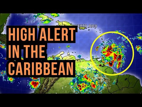
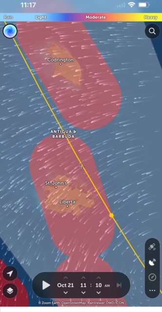
- Torrential rains
|
- By eli fuller <eliantigua at gmail.com>
- Date: Sun, 22 Oct 2023 10:51:37 -0400
|
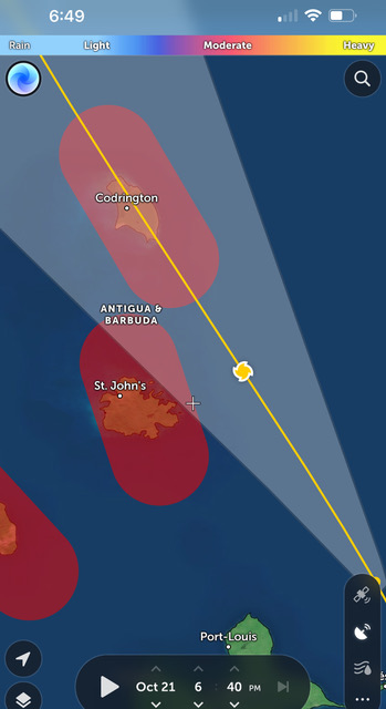
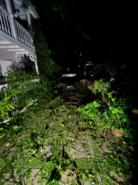
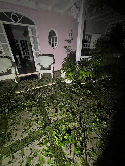
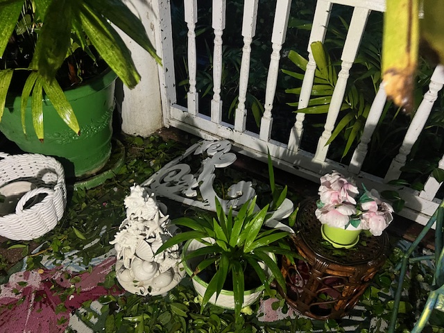
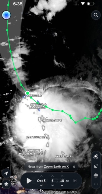
It's been a while since I sent in a report. My dad, John Fuller who's been gone a few years now and was a regular contributor here, would have been a bit disappointed that we didn't get more "action". He loved storms. That being said, his "boys in the back room" are getting a good soaking at this hour as a huge band of heavy rain is over us. Winds are not that strong with gusts in jolly harbour from the south at about 25-30 mph from the feel of it. The land is pretty wet at the moment so if this continues, we will have some flooding for sure in the usual places. Next door in Guadeloupe my friend Pilou who's enjoying a stormy birthday at home, told me that much of the island is "under water". I'll try and attach a radar loop showing what we are getting right now. Looks heavy and hopefully doesn't last too long. Hopefully it's "October all over" now. All the best everyone. Attachment:
Screen_Recording_20231022_104211_Chrome.mp4
Description: MP4 movie
|
|
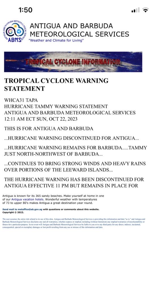
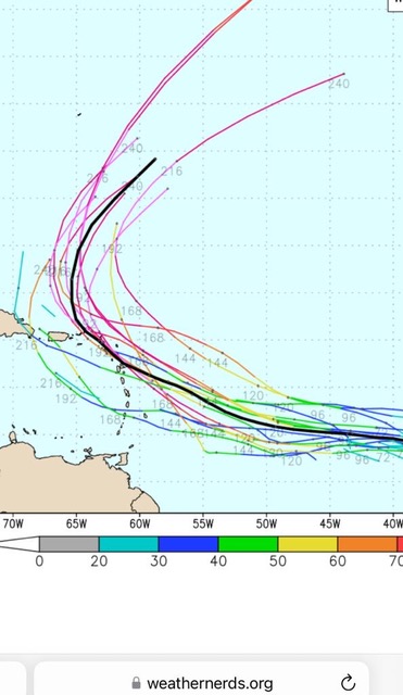
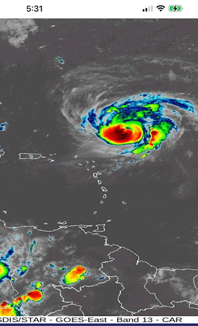
- Hurricane Tammy passed
|
- By Martha Gilkes <gilkesm at me.com>
- Date: Sun, 22 Oct 2023 02:36:27 -0400
|
We have weathered the storm!  Hope Barbuda is ok    🙏   We still have outer
bands to come so today will be gusty
Still in darkness  and locked behind my metal hurricane shutters so have not
checked for damage
Thanks 🙏 to all who sent concerns   Have hardly slept for 48 hours!  Happy and
thankful to see  Tammy move out.  Hope no one else is in harms way !


|
|
- CHANGE OF HURRICANE TRACK
|
- By Martha Watkins Gilkes <marthawatkinsgilkes at gmail.com>
- Date: Sat, 21 Oct 2023 19:24:05 -0400
|
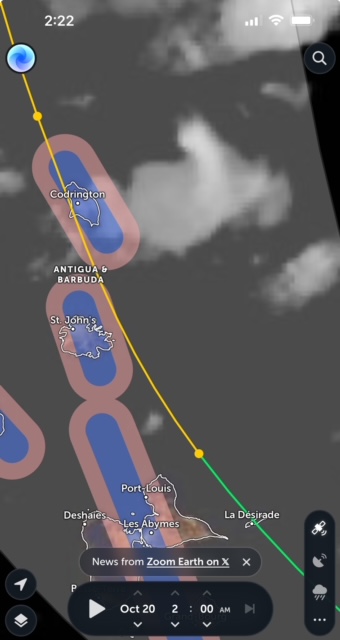
IT SEEMS HURRICANE TAMMY HAS ONCE AGAIN SHIFTED TO THE WEST AND WILL GO OVER BARBUDA UNLESS THIS CHANGES AGAIN. WE ARE WAITNG FOR THE 8 PM UPDATE. ANTIGUA was sooo lucky to dodge the bullet and not have a direct hit as they forecast. BUT OUR HEARTS GO OUT TO OUR LITTLE SISTER ISLAND BARBUDA !
|
|
|
- ANTIGUA AIRPORT CLOSED FOR HURRICANE TAMMY
|
- By Martha Watkins Gilkes <marthawatkinsgilkes at gmail.com>
- Date: Sat, 21 Oct 2023 13:54:03 -0400
|
|
|
|
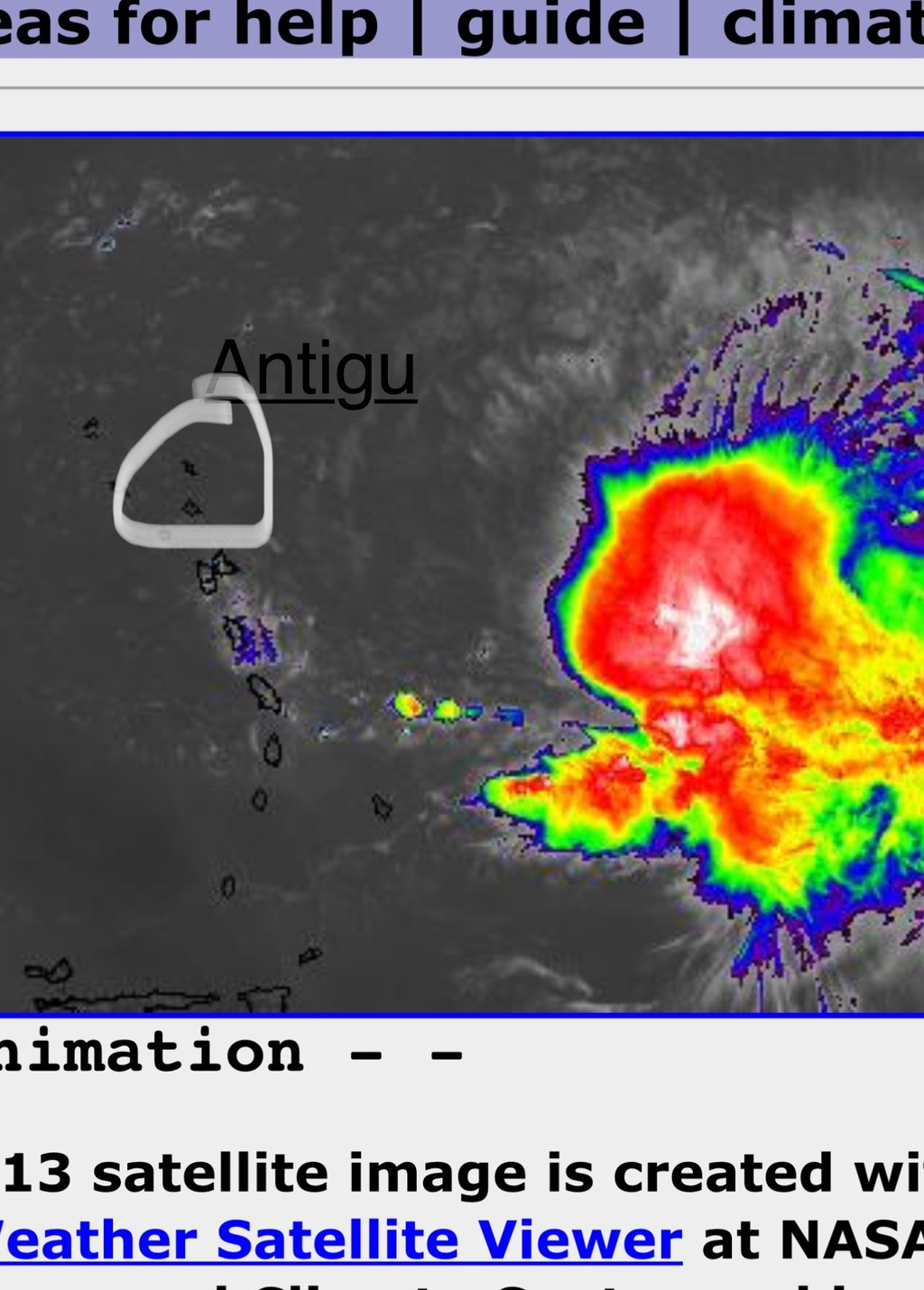
- Antigua
|
- By Andre Sharpe <andresharpe1 at gmail.com>
- Date: Sat, 21 Oct 2023 13:38:12 -0400
|
Hi Gert,
Currently, a mild breeze here in Antigua with overcast skies. We had some sunshine earlier today. The showers have been off and on and quite scattered. We await anxiously for the arrival of hurricane Tammy.
-- |
|
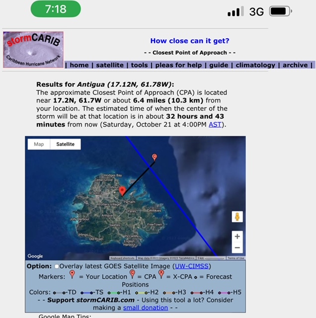
- Better news
|
- By Martha Gilkes <gilkesm at me.com>
- Date: Sat, 21 Oct 2023 11:59:56 -0400
|
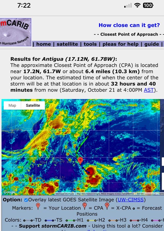
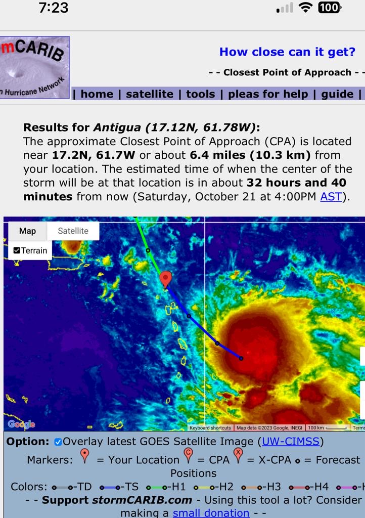
SOME   BETTER NEWS    TAMMY HAS SHIFTED BACK to the  EAST   ( see 2  photos
showing this )  which is  GOOD NEWS for us  with that being the  strongest
winds  ( in the East)    .      The 11 AM  revealed this
             TAMMY STRENGTHENS A LITTLE JUST EAST OF GUADELOUPE...
...HURRICANE CONDITIONS AND HEAVY RAINS EXPECTED IN PORTIONS OF THE LEEWARD
ISLANDS LATER TODAY AND TONIGHT...
Satellite and radar data indicate that the core of Hurricane Tammy is quite
compact and despite its close proximity to the islands, the strong winds remain
just offshore. The initial intensity is adjusted upward to 85mph, however, as
noted above, the hurricane-force winds are occurring over a small region very
near the center of the system.
The hurricane has turned to the right over the past several hours, and the
initial motion is now northwestward, 325 degrees, at 8 mph.
A continued northwestward motion is expected during the next 12-24 hours,
taking the core of Tammy over or just east of the Leeward Islands during that
time.
The NHC track forecast is a little to the right and slower than the previous
one based on the initial position/motion and latest model guidance.
We will  STILL  Get  Hurricane  winds  but   not the worst of them so this is a
good thing .. The System  is getting very near to antigua  now..    105 MILES
 we will start feeling the effects  in a few hours .
Sent from my iPhone
|
|
- HURRICANE LOOKING worse
|
- By Martha Watkins Gilkes <marthawatkinsgilkes at gmail.com>
- Date: Sat, 21 Oct 2023 07:55:54 -0400
|
Very concerning on what we are soon facing. 
|
|
|
- 2 am Hurricane Tammy
|
- By Martha Watkins Gilkes <marthawatkinsgilkes at gmail.com>
- Date: Sat, 21 Oct 2023 02:33:35 -0400
|
21st.  Oct   2 am
Reported to Storm Carib

From Steve on Antigua Weather

Reconnaissance aircraft data indicate that the hurricane has strengthened
slightly and surface winds from Air Force and NOAA Hurricane Hunter aircraft
support an intensity of 80 mph for the 11 pm advantage

Tammy is still moving west-northwestward or at about 295/9 mph, so the
anticipated northwestward turn has not yet occurred......Based on the more
westward motion observed
by the Hurricane Hunters, the official track forecast has been
shifted somewhat to the west of the previous one through 48 hours, which is not
great news for us here in Antigua as it suggests the center passing closer to
us  tonight around. 9 pm October  21st

Not getting  much shut eye ! Hard rain falling at Half moon bay.
Sent from my iPhone
|
|
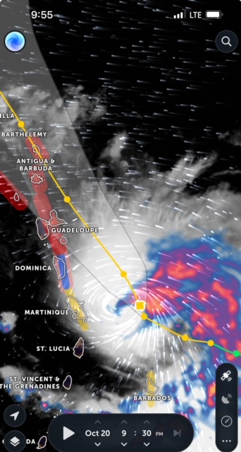
- Hurricane Tammy approaching
|
- By Martha Gilkes <gilkesm at me.com>
- Date: Fri, 20 Oct 2023 21:59:08 -0400
|
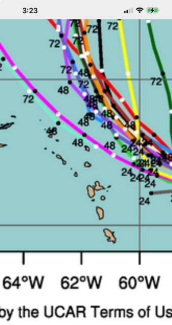
As I try to get a few hours sleep this is what is coming !
Sent from my iPhone
|
|
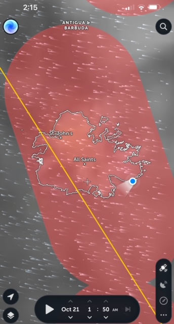
- Closest point
|
- By Martha Gilkes <gilkesm at me.com>
- Date: Fri, 20 Oct 2023 08:37:04 -0400
|
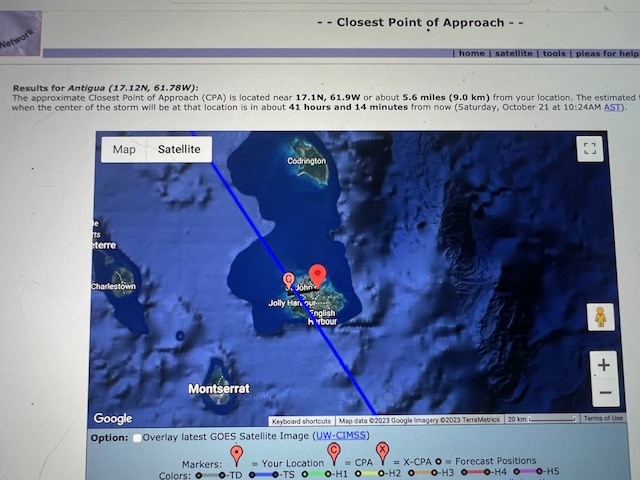
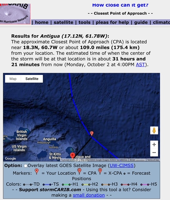
Latest shows very close to us.
Sent from my iPhone
|
|
- 2 am advisory
|
- By Martha Gilkes <gilkesm at me.com>
- Date: Fri, 20 Oct 2023 02:46:35 -0400
|
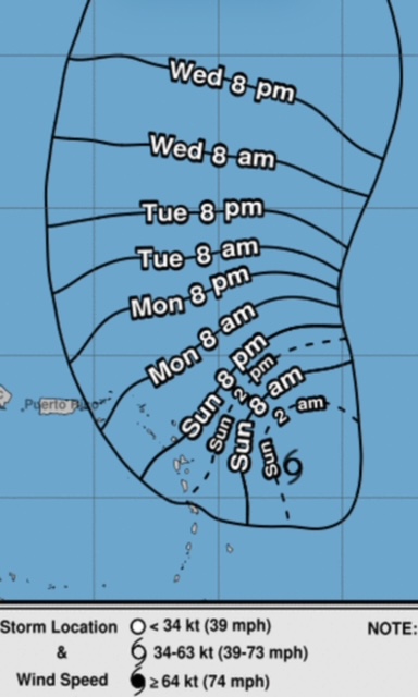
This locates Hurricane Tammy closer to Barbuda!

Sent from my iPhone
|
|
- Closest point
|
- By Martha Gilkes <gilkesm at me.com>
- Date: Thu, 19 Oct 2023 21:11:51 -0400
|
Sent from my iPhone
|
|
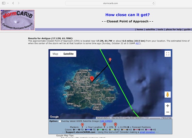
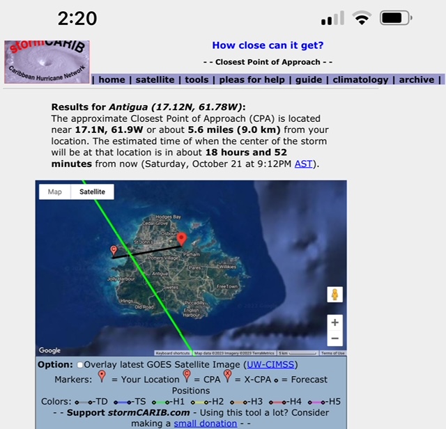
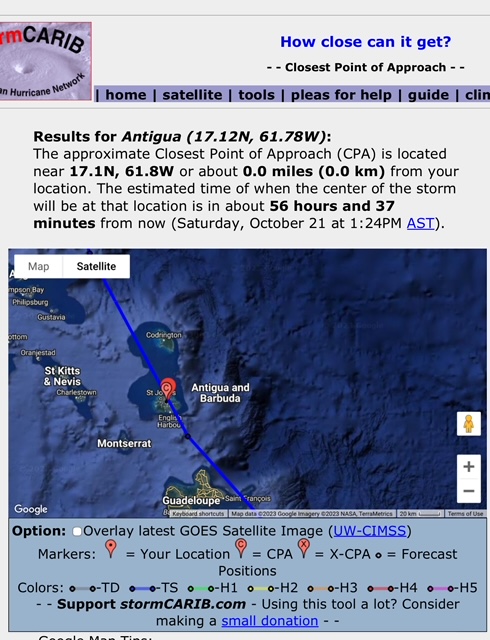
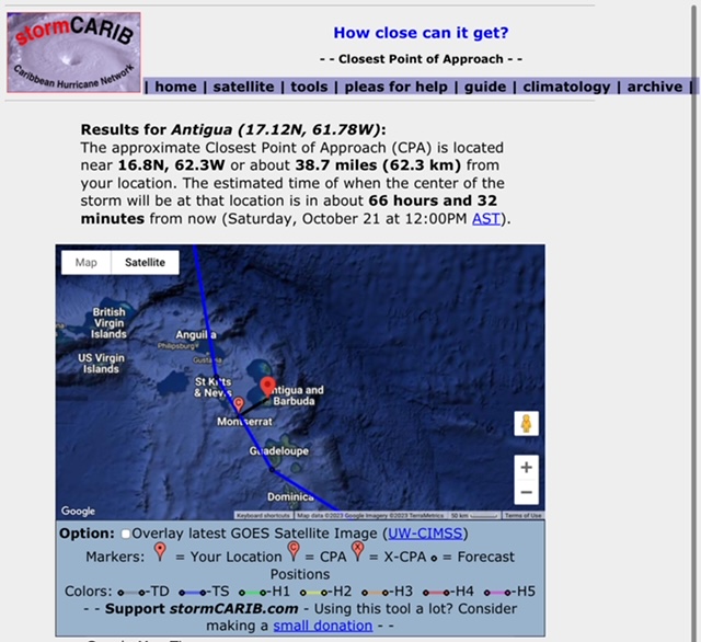
- How close can it get? - Closest Point of Approach - Caribbean Hurricane Network
|
- By Martha Watkins Gilkes <marthawatkinsgilkes at gmail.com>
- Date: Thu, 19 Oct 2023 20:47:11 -0400
|
This ONE IS TRICKY it keeps changing !! WEATHER… but it seems Antigua will get a big hit !!! Stay tuned for the next check in !!!
https://stormcarib.com/closest5.htm
Martha Watkins Gilkes Dolphin View, Half Moon Bay Estate
ANTIGUA, WEST INDIES
FANTA SEA ISLAND LTD
268 764 7722- cell & Whats App
marthawatkinsgilkes at gmail.com
Women Divers Hall of Fame 2002
https://www.wdhof.org
https://www.wdhof.org/members/martha-gilkes
ELKHORN MARINE CONSERVANCY
RESTORING CORAL ONE STEP AT A TIME !
Ways to Donate AND MAKE A DIFFERECE
https://www.emcantigua.org
Explorers Club Fellow International
https://www.explorers.org
|

|
|
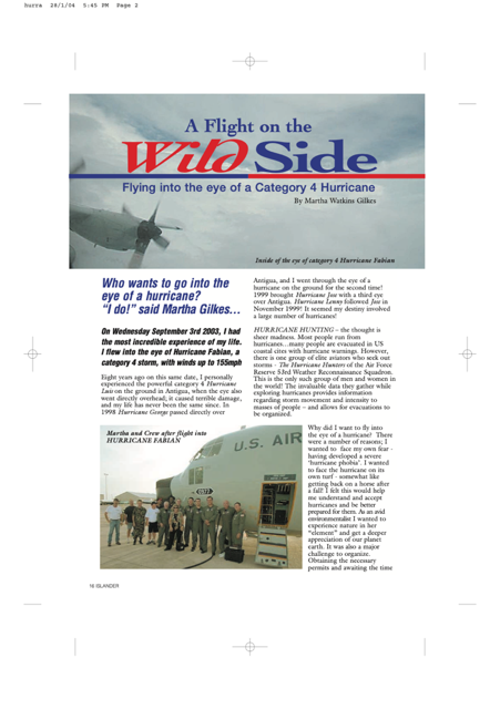
- A FLIGHT ON THE WILD SIDE
|
- By Martha Watkins Gilkes <marthawatkinsgilkes at gmail.com>
- Date: Thu, 19 Oct 2023 16:17:46 -0400
|
My life has been intertwined with Hurricanes for many years ! In 1995 I personally experienced the powerful category 4 Hurricane Luis on the ground in Antigua, when the eye also went directly overhead; it caused terrible damage, and my life has never been the same since. In 1998 Hurricane George passed directly over Antigua, and I went through the eye of a hurricane on the ground for the second time! 1999 brought Hurricane Jose with a third eye over Antigua. Hurricane Lenny followed Jose in November 1999! It seemed my destiny involved a large number of hurricanes! In 2005 I flew INTO THE EYE of CATAGORY 4 Hurricane Fabian with the HURRICANE HUNTERS as Press. ( see link below for more on that experience ) 2 weeks ago here in ANTIGUA I went thru what was TROPICAL STORM PHILLIPE but it sure seemed like MUCH MORE THAN a STORM given the Damage and destruction. I am now facing what will become HURRICANE TAMMY predicted to have a DIRECT PASS OVER THE TOP of ANTIGUA! We are hoping for the best and that our paradise island does not have terrible damage. Thanks for all who have sent prayers and concern our way ! AND THANKS TO GERT OF STROM CARIB FOR POSTING THIS STORY AND DOCUMENTING THE HISTORY !!

|
|
|
- Storm Tammy & Antigua Barbuda
|
- By Martha Gilkes <gilkesm at me.com>
- Date: Thu, 19 Oct 2023 08:08:45 -0400
|
|
|
|
- Storm Tammy
|
- By Martha Gilkes <gilkesm at me.com>
- Date: Thu, 19 Oct 2023 05:06:22 -0400
|
Sent from my iPhone
|
|
- Storm Tammy
|
- By Martha Gilkes <gilkesm at me.com>
- Date: Thu, 19 Oct 2023 04:54:09 -0400
|
Early Thursday morning this track put her right over Antigua!

Sent from my iPhone
|
|
- Tropical Storm Tammy
|
- By Martha Gilkes <gilkesm at me.com>
- Date: Wed, 18 Oct 2023 18:12:29 -0400
|
Sent from my iPhone
|
|
- Antigua on weather watch
|
- By Martha Gilkes <gilkesm at me.com>
- Date: Wed, 18 Oct 2023 09:40:16 -0400
|
Report to Storm Carib

THE HURRICANE HUNTERS WILL FLY the   system  TOMORROW    THURSDAY and this will
give us better information on  the   important aspects.   THE  wind speed   and
  direction,  if there is  center  circulation  and other important  details
 SO  we  hope to have a better  picture on this  TOMORROW THRUSDAY    but this
is a good summary of things    for now  as stated by  Steve on the  Antigua
Weather  Watching site.....   The NHC continues to suggest that Invest 94L is
getting its act together, although there are little signs that the system is
organized enough to be declared a tropical cyclone at this time!
Computer models continue to disagree, mostly on the future strength of the
system, with some showing a TC passing near or just to the NE of the islands
and some that do not develop an organized TC at all, but instead bring 94L
through the island chain as a strong and large tropical wave......The timing
for this is sometime on Friday into the weekend!
Invest 94L is another one of these systems that meteorologists dislike, due to
the difficulty in forecasting them........It is therefore deemed necessary for
residents of the Lesser Antilles to be mindful of the forecast uncertainties
and to be prepared for a worse case scenario until more reliable info is
available.......NB: Watches may be issued for some of the islands later today!
Sent from my iPhone
|
|
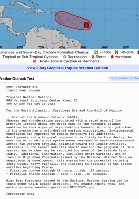
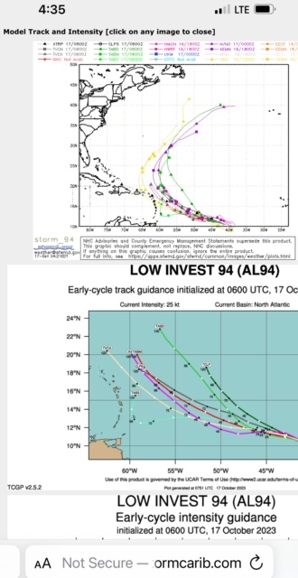
- Invest 94L
|
- By Martha Watkins Gilkes <marthawatkinsgilkes at gmail.com>
- Date: Tue, 17 Oct 2023 05:03:00 -0400
|
Reporting for Storm Carib

On this early Tuesday morning checking a number of weather sites …. Gert’s
Storm Carib.   Weather Nerd. National Hurricane 🌀 Center!   It is a mystery
what this system will do !

The models have this potential hurricane Tammy all over the place.  In the next
4 days  but a lot of uncertainty!   “Err on the side of caution “ I say in
preparation! I will be prepared in full hurricane mode !  The recent Storm
PHILLIPE caught many off guard !
>
>
>
>
>
>
>
>
>
>
> Sent from my iPhone
|
|
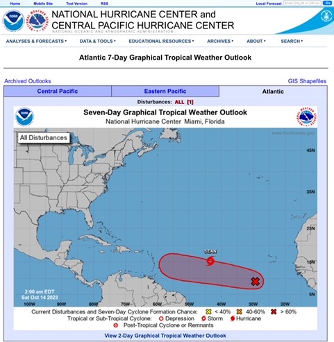
- ? COMING OUR WAY ????
|
- By Martha Gilkes <gilkesm at me.com>
- Date: Sat, 14 Oct 2023 07:03:28 -0400
|
AS WE  wake up this  Saturday    i  dont like the  looks of of  the     94L
which  will become    HURRICANE TAMMY…
The Tracks are   TOOO CLOSE  FOR COMFORT    in around   6 or 7  days  (  so
late next week or the weekend !)    Still have  my HURRICANE SHUTTER UP  from
PHILLIPE   but will  do MORE  if this is  coming this way !!
Sent from my iPhone
|
|
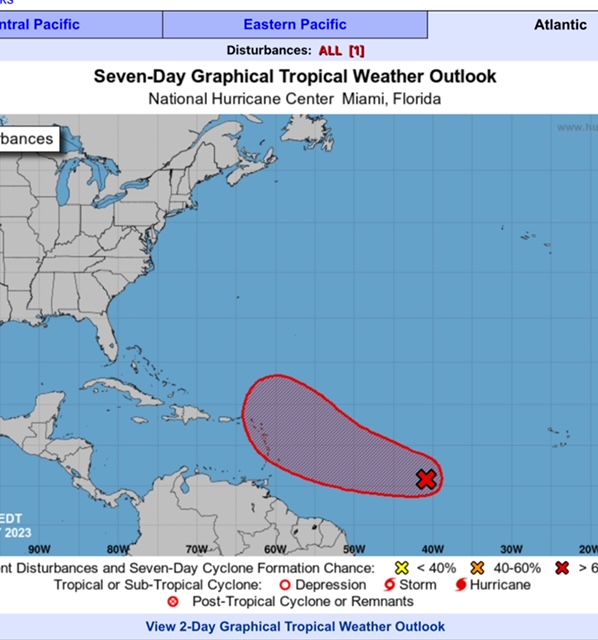
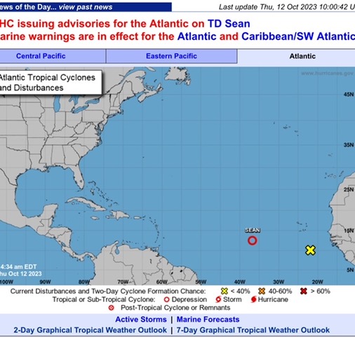
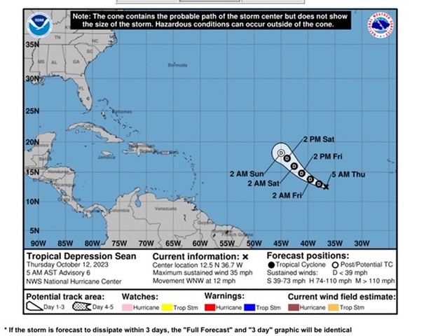
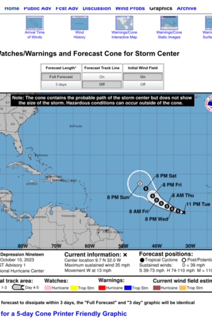
- ANTIGUA MET OFFICE NOTICE
|
- By Martha Gilkes <gilkesm at me.com>
- Date: Fri, 13 Oct 2023 15:37:35 -0400
|
REPORT FOR   STORM  CARIB !!!


Thankfully     STORM SEAN  is not a threat   any longer   but we  are  being
warned to  be alert for what may become    TAMMY   with the path  seeming to
be coming   towards the island  chain  next  week !!!

Will be happy to see the end  of this   hurricane season !!!
Sent from my iPhone
|
|
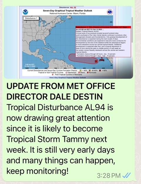
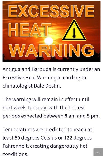
- ANTIGUA WEATHER
|
- By Martha Gilkes <gilkesm at me.com>
- Date: Thu, 12 Oct 2023 10:25:12 -0400
|
STORM CARIB POST

ANTIGUA  IS  UNDER  AN  EXCESSIVE HEAT  WARNING as you see here !!!        SIGN
OF THE TIMES  SADLY !!!

AND  we are  watching the  2  systems   below   coming our  direction !
They say  a NORTH TURN FOR THE NAMED ONE    ( SEAN)     but  who knows   with
weather these  days !!        It looks like the     LOW RIDER  behind     ( the
yellow   x  and yellow cone)  MAY  stay to the  SOUTH …  but  those MAKE ME
NERVOUS  as they often   wobble to the NORTH…    WE just   double checked all
of our  HURRICANE BOLTS      with good old    WD40  to be  sure we are  ready
to  CLOSE UP  if needed !!!

    FOR  SURE   EYES  TO THE EAST !!!!!

I will keep you weather watchers   posted  !!!

Martha
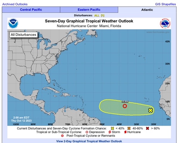
Sent from my iPhone
|
|
- MID WEEK WATCHING
|
- By Martha Gilkes <gilkesm at me.com>
- Date: Wed, 11 Oct 2023 08:16:45 -0400
|
HAPPY TO  wake up and   SEE  THIS  projected  NORTH  TURN of what is NOW NAMED
 TROPICAL STORM SEAN   BUT   we  saw     this same thing with   PHILLIPE
TURNING NORTH……..   and  then he turned    DIRECT to the islands !!!
Also there  is  YET  ANOTHER  system  just off  the  coast   ( the YELLOW  X  )
    and it  is showing  more  of  a   WESTWARD  TURN.    ALL  EYES  TO THE
EAST   for  the  development of these   systems  over the next  week.
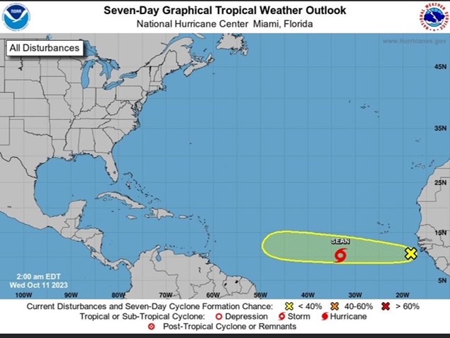
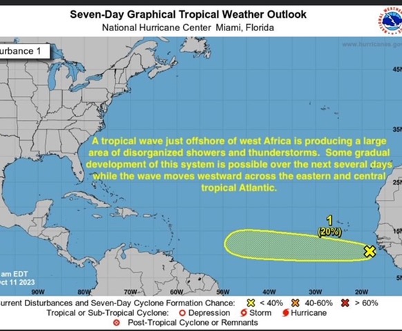
Sent from my iPhone
|
|
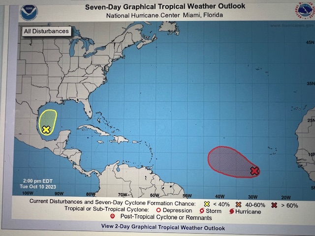
- ANTIGUA WEATHER WATCHING AGIN.....
|
- By Martha Watkins Gilkes <marthawatkinsgilkes at gmail.com>
- Date: Tue, 10 Oct 2023 16:25:29 -0400
|
WATCHING  ANOTHER  one…      This one  started    at  a   VERY  LOW  LATITUDE
which  makes ME  NERVOUS.  but they are  saying    a  NORTH   TURN        THAT
WAS  SAID  FOR  PHILLIPE  TOO  last  week   when he    decided  to  dance
RIGHT  OVER THE  TOP  OF   US  bringing     ILL  WINDS …   This  is   not far
off  CAPE VERDE  ISLAND     about  1800  aways from  ANTIGUA  so   still   a
long way  off  and   they are  NOT  GIVING  ANY  WIND  SPEED  so  hard to
calculate  when  IF  THIS COMES …     example..   IF   it was  moving   15 MPH
that  is  about   350 miles  /  day  so     5  days or so   away    BUT    it
is to even NAMED YET   so  i dont mean to jump the  gun here…      and   as we
know   WEATHER  IS    A  VERY  CHANGEABLE  THING   so   we   are never  sure
……       BUT  FOR SURE  will be  watching this   daily


>
>
>
>
>
|
|
- After the blow
|
- By Martha Gilkes <gilkesm at me.com>
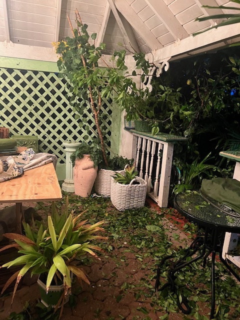
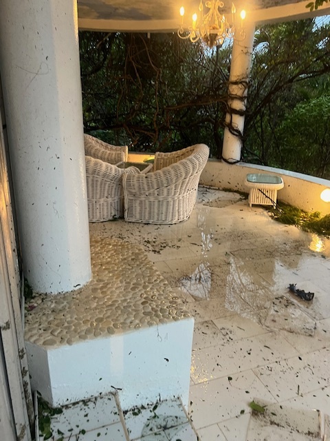
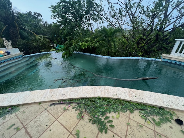
- Date: Tue, 3 Oct 2023 20:52:00 -0400
|
Catching my breath after a sleepless storm night“ Or so we were told Storm
only. 🤷♀️ I am a seasoned hurricane 🌀 person. Been thru the eye of 5
hurricanes )another story. This was more than expected! Photos show. Not
mega structure damage but lots of clean up mess to organize! No
electricity. Cell phone down Luckily minimal structural damage but work to
do ! Seems a lot were caught off guard thinking STORM only. This PHILLIPE
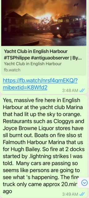
was one wierd one ! Most tragic thing is the lightning strike on Antigua
Yacht club marina which burned it down (previously posted ) thinking of so
many suffering as a result. Start my own cleanup tomorrow

Sent from my iPhone
|
|
- Fire destroying location.
|
- By Martha Gilkes <gilkesm at me.com>
- Date: Tue, 3 Oct 2023 05:05:43 -0400
|
|
|
|
- Antigua
|
- By Martha Gilkes <gilkesm at me.com>
- Date: Tue, 3 Oct 2023 02:34:48 -0400
|
Very strong winds beating us up. Pray for the passing !
|
|
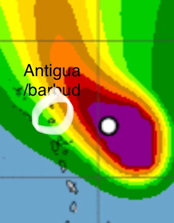
- STORM PHILLIPE ON TOP OF US
|
- By Martha Watkins Gilkes <marthawatkinsgilkes at gmail.com>
- Date: Mon, 2 Oct 2023 21:18:58 -0400
|
 What a difference   a  day makes  THEY SAY!!!   yesterday   OCT   1  I posted
on this site     thinking all  WAS  GOOD for  us and   Storm   Phillipe was
GOING TO MAKE THE  NORTH TURN..   I  am  a  seasoned  HURRICANE PERSON  and
know  WEATHER  always  surprises  us !       and   as  is the case with
WEATHER..  it all   went   HAY WIRE  with things  changing   and suddenly
this storm is on  our door step .   WE are  212  feet  above sea level so  FEEL
THE WIND more than  others  not as  high.    and the wind is  BLOWING NOW…
and  this is just  starting !   But  still thankful  it is not  HURRICANE WINDS
..  Will   try to report  as we go forward .   Hope the    ELECTRICITY and
INTERNET HOLDS UP..       It is just  starting now.
|
|
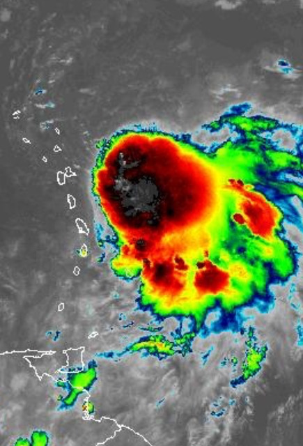
- STORM PHILLIPE
|
- By Martha Watkins Gilkes <marthawatkinsgilkes at gmail.com>
- Date: Sun, 1 Oct 2023 17:14:38 -0400
|
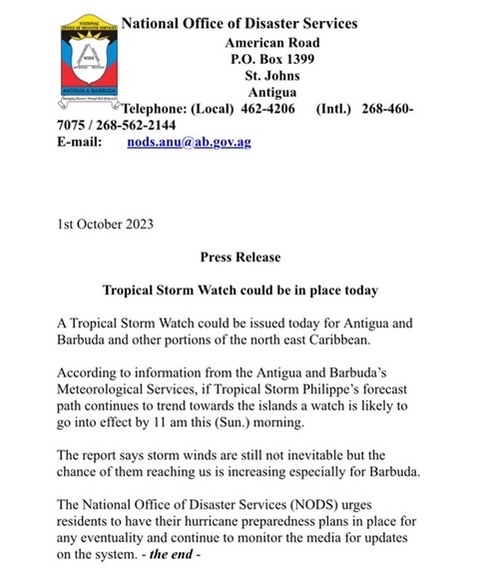
THE 5 PM NATIONAL HURRICANE ADVISORY IS OUT and seems GOOD NEWS TO ME for Antigua & Barbuda.
An Air Force Reserve Hurricane Hunter aircraft is scheduled to be inside the storm tonight. THiS is the most accurate info we can get ; moreso than satellite images so we will have a better picture after tonight.
I think the 5 am TOMORROW OCT 2nd will give us a much better picture of what Antigua and Barbuda can expect. If the North turn continues it will mostly be a rain event. KEY MESSAGES:
1. Tropical storm conditions are possible across portions of the
northern Leeward Islands Monday and Monday night while Philippe
passes near or just northeast of the area, and a Tropical Storm
Watch is in effect for Antigua and Barbuda. Interests elsewhere
in the northern Leeward Islands should continue to monitor this
system as additional watches or warnings could be required later
today or tonight.
2. Heavy rainfall from Philippe could produce isolated to scattered
flash flooding, particularly across Barbuda and Antigua, through
Tuesday.
Stay tunes for the early morning advisory on October 2nd |
|
|
- STORM ON OUR DOORSTEP
|
- By Martha Gilkes <gilkesm at me.com>
- Date: Sun, 1 Oct 2023 15:49:55 -0400
|
WE have this   VERY  STRANGE    weather  system  dancing on our  door  step  as
we have been  watching for some days but thinking it would     GO NORTH …...
IT IS NOT  A HURRICANE     …   IT  was  SUPPOSE TO  GO  NORTH  and Miss the
islands but  as we know  with  WEATHER  THINGS  CHANGE …         see  the text
 for  EXPERT   DAVES  comments on it all     ( FROM  STORM CARIB  main page )
 I  ALWAYS   ere  on the  side of  CAUTION   so pulling   EASY GIRL OUT OF
HARMS WAY  this morning..     Standing by to   decide tomorrow on   any other
action  needed !
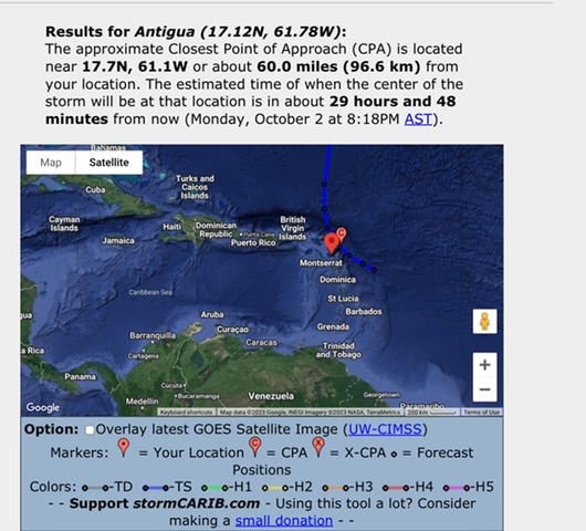
MOVED FROM BEING 109 MILES AWAY to now 60 MILES AWAY

Sent from my iPhone
|
|
- STORM WATCHING
|
- By Martha Gilkes <gilkesm at me.com>
- Date: Sun, 1 Oct 2023 08:53:12 -0400
|
TOOOO  CLOSE  FOR COMFORT        Watching this..       Antigua may  get
clipped    with some  storm winds !!!

PULLING  OUR BOAT UP  THIS  MORNING

Sent from my iPhone
|
|
- STORM PHILLIPE
|
- By Martha Gilkes <gilkesm at me.com>
- Date: Sat, 30 Sep 2023 12:53:03 -0400
|
THIS  IS   TOOOO CLOSE FOR COMFORT !!!  just  on  our  DOORSTEP..     Seas  are
 rough  but  no  wind  !!    ALL MODELS  show the  turn  below     by  MONDAY
around  NOON !!     ALTHOUGH  I  am  a very seasoned  HURRICANE  WATCHER  this
one makes me    nervous and  I will   very thankful  for that north turn…  If
something  changes   with the movement     we  could  be in for a  BIG    OH
MY GUD MOMENT !!!       WE  are   watching   waiting   and praying for the
TURN  but  at least  it is NOT  a hurricane .

Sent from my iPhone
|
|
- WEATHER WATCHING
|
- By Martha Watkins Gilkes <marthawatkinsgilkes at gmail.com>
- Date: Thu, 28 Sep 2023 15:58:14 -0400
|
STRANGE THINGS ON OUR DOOR STEP with these 2 systems almost FLIRTING with each other !! This makes us a bit NERVOUS as it seems they dont even know where they are going.. WE ARE CAREFULLY WATCHING THESE few days. THINKING WE should PULL UP OUR EASY GIRL BOAT to be safe !!!
STANDING BY FOR TOMORROW…
https://x.com/268Weather/status/1707470198477922648?s=20
|
|
|
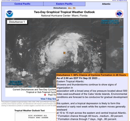
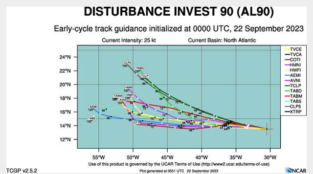
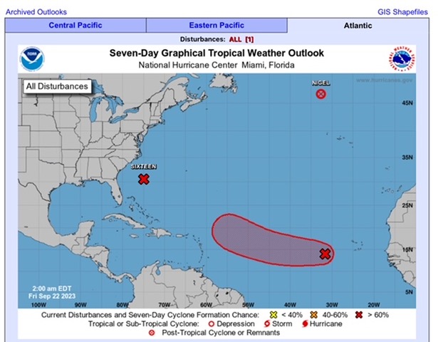
- 90L weather system
|
- By Martha Gilkes <gilkesm at me.com>
- Date: Fri, 22 Sep 2023 07:42:13 -0400
|
WE   continue to watch this   system     with    2 models  having it over the
NORTHEN LEEWARDS   (  ANTIGUA & BARBUDA!!)  but  hope it follows  the earlier
ones  and   turns  NORTH..    IT   WILL  BECOME   PHILIPPE  in due course !
SO the next week  is  watching as   this  system dances across the  Atlantic ……
  Beautiful days  in the islands  just now   BUT  VERY VERY HOT  !!
Sent from my iPhone
|
|
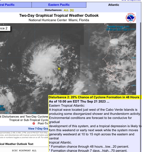
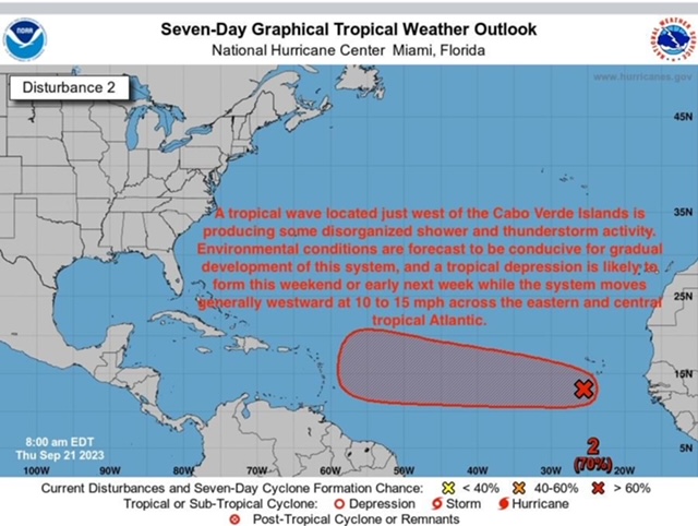
- New weather system
|
- By Martha Gilkes <gilkesm at me.com>
- Date: Thu, 21 Sep 2023 12:15:47 -0400
|
Folks we have another on off Africa.  May shift north may come over our beloved
islands!   Stay tuned in a week or so !

|
|
- STORMY WEATHER in Antigua LAST NIGHT
|
- By Martha Gilkes <gilkesm at me.com>
- Date: Sat, 16 Sep 2023 12:15:20 -0400
|
Last night in Antigua we had VERY VERY STORMY WEATHER develop almost on top of us !! Lightening and Thunder like I have not heard for a long time ! and a lot of rain! (thankful for) We did have some on and off gusty winds also. This Morning in reviewing my weather sites MR WEATHERMAN showed what developed over Antigua last night ( big red blob below) but today we are back to SUNNY WEATHER!!
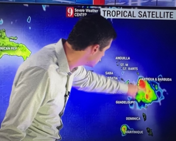 Sent from my iPhone |
|
|
- Hurricane Lee
|
- By Martha Gilkes <gilkesm at me.com>
- Date: Mon, 11 Sep 2023 06:58:25 -0400
|
Today Remembering 9 —11 22 years ago. Such tragic times.
On this early morning Hurricane Lee is still giving Antigua gusty west winds as you see on this site. 5 am advisory shows movement is only 7 MPH so very slow ! Will be happy to see this one move on. Watching now. 97L due towards the end of the week ! Hope for a northern turn
http://www.antiguamet.com/ |
|
|
- Passing of Hurricane Lee
|
- By Martha Gilkes <gilkesm at me.com>
- Date: Sun, 10 Sep 2023 16:27:51 -0400
|
 TODAY   WE  ARE   feeling   the  passing of   HURRICANE  LEE  SHOWN  just
above the island chain   with the  outer  band winds   coming from the  WEST..
      So thankful  as to what could have happened with  a more  direct hit.
 hoping those in the path now  are spared…….

      WE have    only had coastal damage  on   the   beaches with    big  surge
        but the  positive  of that  for  the  EAST  COAST  BEACHES    the
invasive seaweed has  been  washed out and   away    and the  beaches are
beautiful !!           HOWEVER NEGATIVE IS THE     WEST COAST  BEACHES    Have
  SEAWEED  BROUGHT in  by  a west wind.     These  beaches should  be clear
when the wind  shifts again!       MOTHER  EARTH is  sure  angry     we are
living in trying times
Sent from my iPhone
|
|
- Hurricane Lee passing ANTIGUA
|
- By Martha Gilkes <gilkesm at me.com>
- Date: Sat, 9 Sep 2023 08:30:24 -0400
|
HALF MOON BAY BEACH swells rolling in
  |
|
|
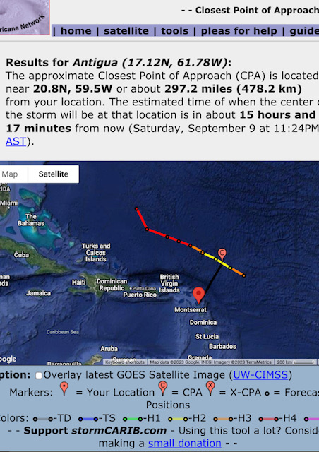
- SATRUDAY MORN HURRICANE LEE PASSING
|
- By Martha Gilkes <gilkesm at me.com>
- Date: Sat, 9 Sep 2023 08:29:28 -0400
|
 Martha  Reporting for   STORM  CARIB       ( www.stormcarib.com )   As we
wake this morning  Hurricane LEE  is Moving on  to THE NORTH OF  THE ISLANDS
thankfully  with  the closest point
being  TONIGHT    1124   PM..    Big  swells are   washing in on  HALF MOON
BEACH below  my house   with the good news  of it  cleaning up the beach of all
the  invasive  sea weed   that has plagued   us.   We hope  NO ONE WILL BE
EFFECTED BY HURRICANE LEE  as  the systems moves  north    especially  watching
 our  family in   BERMUDA !!!!

    STILL WATCHING  THE WEATHER    Coming off  Africa   as  Hurricane season is
NOT OVER  yet!

Sent from my iPhone
|
|
- ANTIGUA watching HURRICANE LEE
|
- By Martha Gilkes <gilkesm at me.com>
- Date: Fri, 8 Sep 2023 20:23:04 -0400
|
Martha REPORTING FOR STORM CARIB HERE from Antigua… thank you to those who keep us in your thoughts and prayers in these hard times.
AS we watch this monster hurricane “skirting” our islands tonight and over the next few days we are so thankful we are not getting a direct HIT which would be so destructive ! But we are still not OUT OF THE WOODS as we have just been sent by our CAP ALERT SYSTEM this notice for HIGH SEAS … I am located on the EAST COAST and we are in the warning zone for the high surf. Praying it will be LESS THAN MORE and also for any in the path especially my Bermuda family !! Nature is really angry at MANS ABUSE OF the environment! It is our pay back time ! Let’s all do our part in whatever way we can to PAY BACK….. and help MOTHER EARTH HEAL! ??? too little tooo late ??? 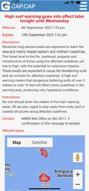 Sent from my iPhone |
|
|
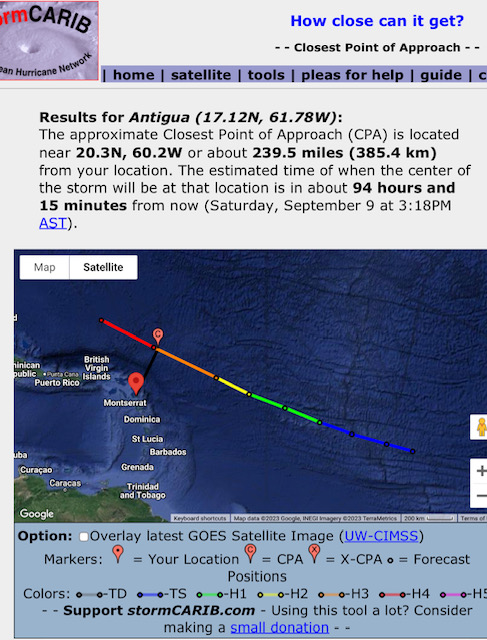
- Hurricane Lee
|
- By Martha Watkins Gilkes <marthawatkinsgilkes at gmail.com>
- Date: Thu, 7 Sep 2023 15:27:50 -0400
|
|
|
|
- Hurricane Lee
|
- By Martha Gilkes <gilkesm at me.com>
- Date: Tue, 5 Sep 2023 17:09:55 -0400
|
Looking like we will be spared Hurricane Lee  passing this weekend to our north
🙏. Very grateful for this
Sent from my iPhone
|
|
- Hurricane development
|
- By Martha Gilkes <gilkesm at me.com>
- Date: Mon, 4 Sep 2023 16:48:44 -0400
|
We are watching. Looking like it might pass north of us 🙏
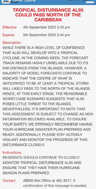
Sent from my iPhone
|
|
- All Eyes East
|
- By Mario-Dorecia Lewis <mariodorecialewis at gmail.com>
- Date: Mon, 4 Sep 2023 14:10:18 -0400
|
I think everyone is watching this new development to our east for further signs of development. While all of the islands could use some rain, we certainly do not want a storm, an even worse a Hurricane. I am hoping that it shocks all of us and stears north. Prayers up!
Dorecia L. Antigua |
|
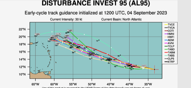
- potential HURRICANE DEVELOPING
|
- By Martha Watkins Gilkes <marthawatkinsgilkes at gmail.com>
- Date: Sun, 3 Sep 2023 10:15:44 -0400
|
WE ARE VERY CAREFULLY WATCHING THIS AS it develops over the next few day
PEOPLE GET ready!!!
|
|
|
- Active weather systems!
|
- By Martha Gilkes <gilkesm at me.com>
- Date: Sat, 2 Sep 2023 06:15:18 -0400
|
Latest system just off Africa worth watching as it could come our way.
|
|
- RAIN AND MORE RAIN
|
- By Martha Watkins Gilkes <marthawatkinsgilkes at gmail.com>
- Date: Sun, 20 Aug 2023 15:41:35 -0400
|
Antigua Is getting LOTS OF RAIN JUST NOW.. my own house had flooding and we are on a hill so am sure our low lying areas are getting flooded. BUT NO WIND and we are thankful for the much needed rain. I hope others along the path do not have damage.
|
|
|
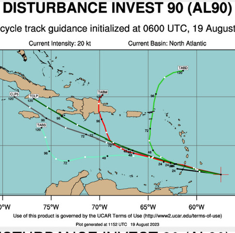
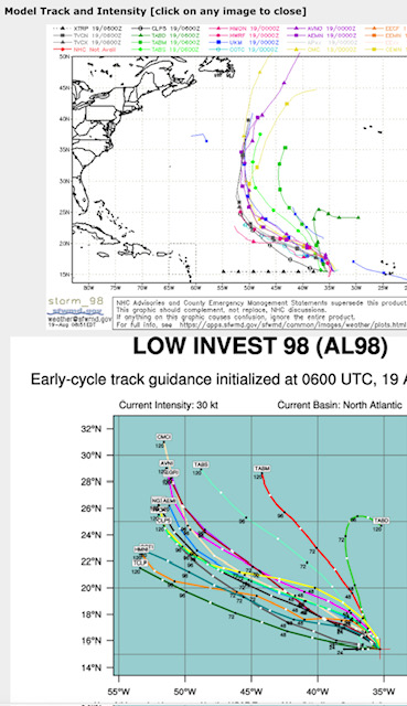
- more on weather watching
|
- By Martha Watkins Gilkes <marthawatkinsgilkes at gmail.com>
- Date: Sat, 19 Aug 2023 12:18:29 -0400
|
More on the systems I just posted about !
|
|
|
- WEATHER WATCHING
|
- By Martha Gilkes <gilkesm at me.com>
- Date: Sat, 19 Aug 2023 11:43:42 -0400
|
WE are all   watching these    THREE   SYSTEMS  dancing on our  door step.
It is  THAT  TIME OF YEAR.       The Models  seem to  indicate  we  will not be
 effected  with the projected tracks…but  in the bottom  photo  the islands
are  showing  a  bigger scale.    WE will  continue to monitor.

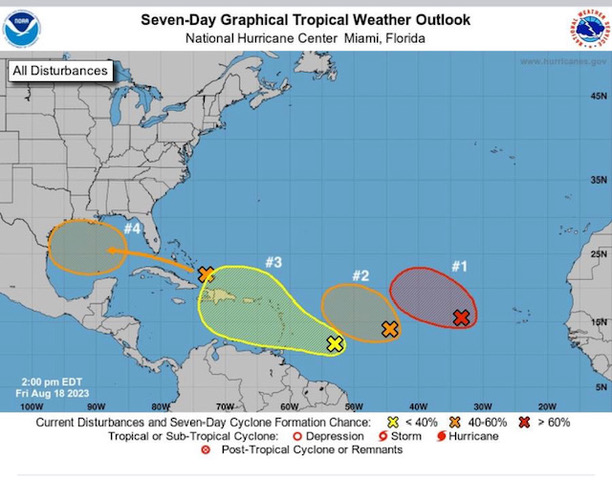
Sent from my iPhone
|
|
- Weather watching
|
- By Martha Gilkes <gilkesm at me.com>
- Date: Thu, 20 Jul 2023 11:52:47 -0400
|
Another system we are watching.
Hope for some rain !
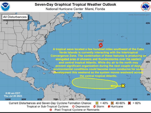
Sent from my iPhone
|
|
- Tsunami
|
- By Martha Watkins Gilkes <marthawatkinsgilkes at gmail.com>
- Date: Mon, 10 Jul 2023 18:48:40 -0400
|
|
|
|
- More on the quake
|
- By Martha Gilkes <gilkesm at me.com>
- Date: Mon, 10 Jul 2023 18:47:27 -0400
|
|
|
|
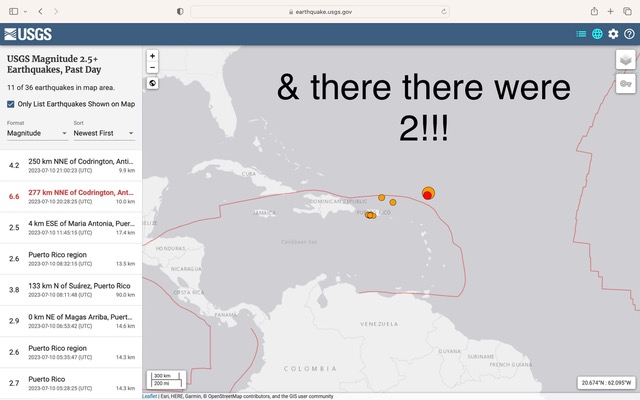
- AND THEN THERE WERE 2 !!!!
|
- By Martha Gilkes <gilkesm at me.com>
- Date: Mon, 10 Jul 2023 17:50:47 -0400
|
30 Minutes after  the first  tremor  we had  a  second one!       Life  in
paradise !!!!
Sent from my iPhone
|
|
- ANTIGUA EARTHQUAKE..
|
- By Martha Gilkes <gilkesm at me.com>
- Date: Mon, 10 Jul 2023 17:34:38 -0400
|
 Antigua  is   POPPING UP ON  SITES   like    below  from the   shake  we had
 one hour  ago now  !!!    WE  did feel it  but  so far seems no damage   but
we  know  we are  in  a fault  area    so  need to   be  alert.   WE  once had
our  swimming pool  crack open !!!  thankfully  not  today !!     Will  report
if i hear  of  any problems from this tremor.
Hope  everyone is  safe !
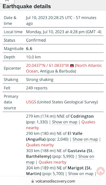

Sent from my iPhone
|
|
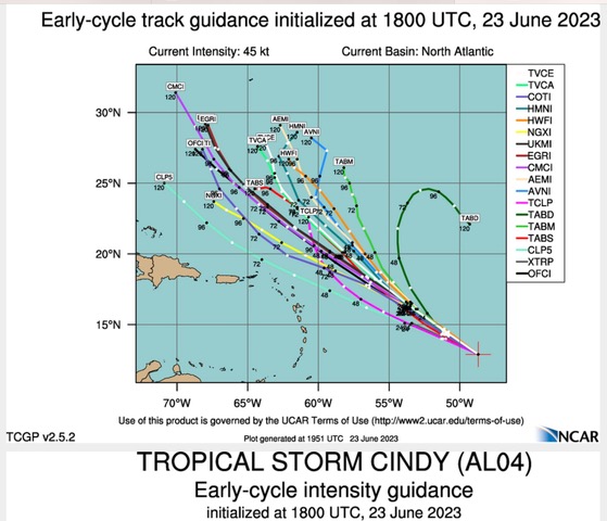
- WATCHING STORM CINDY
|
- By Martha Watkins Gilkes <marthawatkinsgilkes at gmail.com>
- Date: Fri, 23 Jun 2023 16:07:37 -0400
|
WE  are   watching   STORM  CINDY     behind   StORM  BURT  but  all models
are  showing    her  TURNING  AWAY  from the islands  as  is  shown below.
Most  likely this will be  the  case but  it is  WEATHER   and   whether
ChANGES  so   we need to keep monitoring   the  system until  it is  PAST  the
islands.        This  season  has  started     WAY TO  EARLY   in my mind !!

Onwards…..
|
|
- Storm. Burt
|
- By Martha Gilkes <gilkesm at me.com>
- Date: Wed, 21 Jun 2023 05:27:02 -0400
|
Waking early morning the weather is staying to our south but still watching for a wobbly We have seen it before. Thinking of those in the path ! 🙏. More so thinking of the 5 explorers on the lost submarine and praying for a miracle About 20 hours of hope left 🙏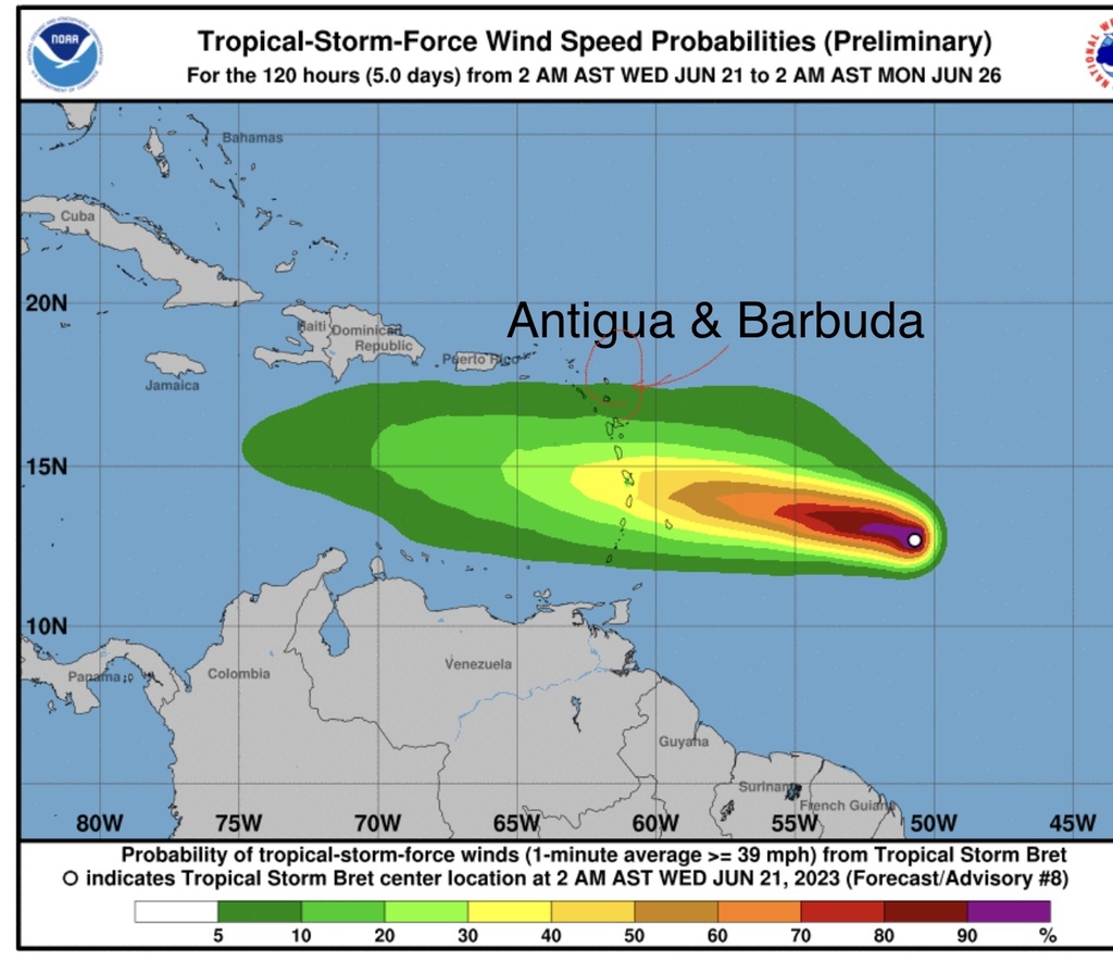
Sent from my iPhone |
|
|
- Storm Bert
|
- By Martha Gilkes <gilkesm at me.com>
- Date: Tue, 20 Jun 2023 16:02:51 -0400
|
The Hurricane Hunters will begin flying into the system which will give much
more acct information on what to expect!   Standing by for that !   Watching.
And waiting!
Sent from my iPhone
|
|
- ANTIGUA WEATHER WATCHING
|
- By Martha Watkins Gilkes <marthawatkinsgilkes at gmail.com>
- Date: Tue, 20 Jun 2023 10:45:12 -0400
|
For Antigua as of TODAY this is the forecast and if it is right this storm willl STAY SOUTH and in this brief below with MR WEATHERMAN …….. the windward islands are mentioned. However Antigua's immediate Southern neighbor is GUADELOUPE so that is a bit CLOSE FOR COMFORT as these systems DO WOBBLE! WE are closely watching to make decision on PUTTING UP HURRICANE SHUTTERS or not !!!
Tropical Storm Bret is moving to the Caribbean, and it could become a hurricane. Bret is on track to bring at least tropical storm conditions to St. Lucia, Barbados, Guadeloupe, Dominica, Martinique, and St. Vincent and the Grenadines. Tropical Storm and Hurricane preparations should be made in these locations, just to be safe.
CHECK OUT MR WEATHERMAN
https://youtu.be/CSCPcHlC4D8
|
|
|
- Issued by the Antigua Met Office
|
- By Martha Watkins Gilkes <marthawatkinsgilkes at gmail.com>
- Date: Mon, 19 Jun 2023 20:25:38 -0400
|
TROPICAL CYCLONE ALERT STATEMENTWHCA31 TAPA
TROPICAL STORM BRET ALERT STATEMENT
ANTIGUA AND BARBUDA METEOROLOGICAL SERVICES
5:00 PM ECT MON, JUN 19, 2023 THIS IS FOR THE LEEWARD ISLANDS AND BRITISH VIRGIN ISLANDS TROPICAL STORM BRET FORMS OVER THE CENTRAL ATLANTIC...
INTERESTS IN THE LESSER ANTILLES SHOULD MONITOR THIS SYSTEM.
AT 5 PM BRETT WAS LOCATED NEAR LATITUDE 11.3N LONGITUDE 42.2W ABOUT 1191 MILES EAST- SOUTHEAST OF ANTIGUA AND BARBUDA AND THE LEEWARD
AND BRITISH VIRGIN ISLANDS.
MAXIMUM SUSTAINED WINDS...40 MPH...65 KM/H WITH HIGHER GUSTS
PRESENT MOVEMENT...W OR 280 DEGREES AT 21 MPH...33 KM/H
MINIMUM CENTRAL PRESSURE...1008 MB...29.77 INCHES
ON ITS PRESENT TRACK, BRET COULD BE NEAR OR SOUTH OF THE LEEWARD ISLANDS BY LATE THURSDAY INTO FRIDAY. THIS COULD BRING LOCALLY HEAVY RAINFALL AND STRONG GUSTY WINDS. THE SPECIFIC AMOUNT OF THE IMPACTS WOULD DEPEND ON THE INTENSITY, SIZE, EVENTUAL TRACK AND FORWARD SPEED OF THIS SYSTEM. HENCE, A TROPICAL STORM OR HURRICANE WATCH MAY BE REQUIRED FOR SOME OF THE ISLANDS IN THE NEXT 48 HOURS OR LESS.
RESIDENTS SHOULD COMPLETE THEIR HURRICANE PLANS AND BE PREPARED TO START TO IMPLEMENT THEM AT A SHORT NOTICE. ALL RESIDENTS IN ANTIGUA AND BARBUDA AND THE REST OF THE LEEWARD AND VIRGIN ISLANDS ARE URGED TO MONITOR THE MOVEMENT OF TROPICAL STORM BRET CLOSELY, AND HAVE THEIR HURRICANE PLANS IN PLACE. THE NEXT ADVISORY WILL BE AT 11 PM ECT OR 0300 UTC FORECASTER
CECIL MATTHEW |
|
|
- And then there were TWO
|
- By Martha Watkins Gilkes <marthawatkinsgilkes at gmail.com>
- Date: Mon, 19 Jun 2023 15:07:36 -0400
|
The system is Tropical Depression #3. With something on her coattail. 🤷♀️.
Strange development going on. Stay tuned

|
|
- WEATHER WATCHING AGAIN
|
- By Martha Watkins Gilkes <marthawatkinsgilkes at gmail.com>
- Date: Sun, 18 Jun 2023 09:31:34 -0400
|
BE AWARE PEOPLE…..

|
|
|
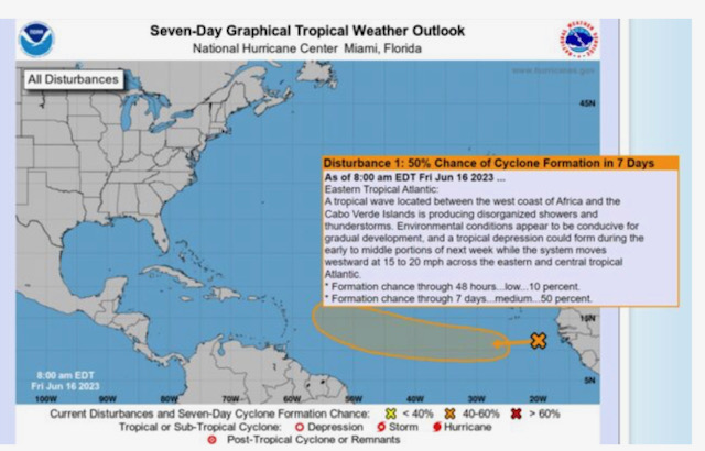
- TROPICAL DISTRUBANCE
|
- By Martha Gilkes <gilkesm at me.com>
- Date: Sat, 17 Jun 2023 08:25:56 -0400
|
WE  ARE   WEATHER   WATCHING ..    THIS  IS  THE   SEASON !   MOST MODELS HAVE
this system making a NORTH turn as it  comes closer to  the  Islands  late next
week  but well worth watching.
|
|
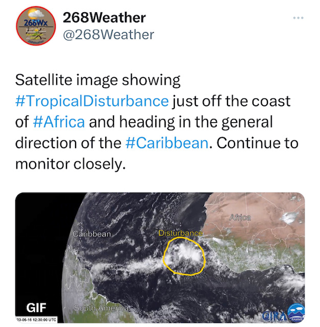
- Weather system
|
- By Martha Watkins Gilkes <marthawatkinsgilkes at gmail.com>
- Date: Fri, 16 Jun 2023 09:20:53 -0400
|
It is very early to have something develop but it  may happen!   Moral to the
story.  People get ready !   It only takes one to mess up our paradise life !
 Be sure hurricane plans are in place.
|
|
- HURRICANE SEASON STARTS !!
|
- By Martha Watkins Gilkes <marthawatkinsgilkes at gmail.com>
- Date: Thu, 1 Jun 2023 12:31:35 -0400
|
| JUNE 1st is the start of HURRICANE SEASON !!! ALSO my wedding anniversary married now 42 years !!! Been a wonderful wild ride !!! An average season is on the cards but as we know IT ONLY TAKES ONE so people get ready as we know being prepared is part of the battle!
Hope you will NOT hear from me very often this season.
Martha
|
|
|
- The beginning of hurricane season is also pineapple season
|
- By Steve Selim <stevenselim at gmail.com>
- Date: Tue, 30 May 2023 15:14:23 -0400
|
|

|
|