|
|
- - - 2012 Hurricane Season - - -
|
- Update
|
- From: "Barbara Cannegieter" <barcann at hotmail.com>
- Date: Sun, 31 Mar 2013 09:05:20 -0400
|
Good Morning and happy Easter
St. Maarten finally received a little more rain last night. It was
cloudy yesterday and we had 2 moderate showers during the day. The early part of
the evening also gave us some heavy rain.
That being said, my little back yard rain gauge this morning only
showed 1/2 inch of rain.
Well,we will take what we can get. All of it is
helpful.
Today is still cloudy. I don’t know if we will get more
rain.
Today and tomorrow are big local beach days so I do hope no rain
falls on their beach picnics.
Enjoy the holidays!
|
|
|
- Update
|
- From: "Barbara Cannegieter" <barcann at hotmail.com>
- Date: Wed, 27 Mar 2013 11:38:56 -0400
|
Well, I don’t know who did that rain dance, but thanks a
lot!
|
|
|
- Update
|
- From: "Barbara Cannegieter" <barcann at hotmail.com>
- Date: Wed, 27 Mar 2013 08:50:35 -0400
|
Position Available Immediately: Master Rain
Dancer
Experienced in bringing rain to dry parched
island.
Knowledge of any and all rainmaking rituals
required.
Goals: fill our cisterns, makes our hills green
again.
|
|
|
- Update
|
- From: "Barbara Cannegieter" <barcann at hotmail.com>
- Date: Sun, 10 Feb 2013 20:30:24 -0400
|
Tonight I said to my family that the weather is a 12.
After a great fish and fungi dinner cooked by my husband, we
sat out on the patio, looking at the stars and enjoying the wonderful tropical
breeze.
It was cool and comfortable and wonderful.
I love this time of year.
The island does need some rain though.
The plants in the garden are starting to droop even though we water
them every day.
We need a good solid soaking
rain.
|
|
|
- Update
|
- From: "Barbara Cannegieter" <barcann at hotmail.com>
- Date: Sat, 5 Jan 2013 10:39:03 -0400
|
Good morning and Happy New Year to everyone.
I see no one has updated any weather reports since Anguilla on
January 2nd.
I guess that is because the weather has been
perfect.
This is the time of year I love. Cool breezy days. No air
conditioning needed at night.
We’ve had a few passing showers but no significant rainfall to
speak of.
The wind is about 17 MPH currently but there are higher
gusts.
The wind is making sea conditions choppy I am sure, so be
careful out there.
Have a good weekend, whatever you
do!
|
|
|
- Update
|
- From: "Barbara Cannegieter" <barcann at hotmail.com>
- Date: Mon, 15 Oct 2012 20:10:33 -0400
|
3 days of rain and just a little while ago we were complaining
of
not enough rain.
Go figure!
Thankfully St. Maarten has had no major problems from Raphael
and
all the rain.
I see he has strengthened now and is heading towards Bermuda. I
hope the storm by passes Bermuda and gives that island no
problems.
They say after a storm, you can see beautiful sunsets, and
tonight
on St. Maarten was no exception.
|
|
|
- Day 3 Tropical storm Rafael
|
- From: Alfonso Blijden <rolandoblij at yahoo.com>
- Date: Mon, 15 Oct 2012 07:15:42 -0700 (PDT)
|
Day 3 of Tropical Storm Rafael and St Maarten beaches still being punded. Waves are about 6 - 10 feet. Regards Alfonso Attachment:
PA150618.JPG
Description: JPEG image
Attachment:
PA150620.JPG
Description: JPEG image
Attachment:
PA150623.JPG
Description: JPEG image
Attachment:
PA150628.JPG
Description: JPEG image
Attachment:
PA150634.JPG
Description: JPEG image
|
|
- Tropical Storm Rafael affecting St. Maarten
|
- From: Alfonso Blijden <rolandoblij at yahoo.com>
- Date: Sun, 14 Oct 2012 18:53:24 -0700 (PDT)
|
Tropical Storm Rafael still affecting St. Maarten. These are pictures taken on the Great Bay Beach in St. Maarten.
Attachment:
PA140596.JPG
Description: JPEG image
Attachment:
PA140602.JPG
Description: JPEG image
Attachment:
PA140600.JPG
Description: JPEG image
Attachment:
PA140592.JPG
Description: JPEG image
Attachment:
PA140599.JPG
Description: JPEG image
Attachment:
PA140603.JPG
Description: JPEG image
Attachment:
PA140594.JPG
Description: JPEG image
Attachment:
PA140606.JPG
Description: JPEG image
Attachment:
PA140605.JPG
Description: JPEG image
Attachment:
PA140593.JPG
Description: JPEG image
Attachment:
PA140604.JPG
Description: JPEG image
Attachment:
PA140595.JPG
Description: JPEG image
Attachment:
PA140597.JPG
Description: JPEG image
Attachment:
PA140598.JPG
Description: JPEG image
|
|
- SxmDCOMM - Advisory #7 - FINAL ADVISORY on TS Rafael - Country under Flash Flood Watch - Drive with Caution in Low Lying Area, Watch out for Rock Falls in Hilly Areas
|
- From: Roddy Heyliger <roddyheyliger at gmail.com>
- Date: Sun, 14 Oct 2012 12:03:16 -0400
|
News Release – IMMEDIATE BROADCAST MEDIA ADVISORY
Department of Communication (DCOMM), Ennia Bldg.,
Longwall Rd., Philipsburg, Sint Maarten W.I. Tel. +1 721 543-1162, 542-4119, Fax: 543-1169;
Email: gis at sintmaarten.net;
Website: www.sintmaartengov.org
For Immediate Release: Sunday, October 14, 2012/N324-Advisory
#7 – FINAL MEDIA ADVISORY on TS RAFAEL
Flash
Flood Watch in Effect until Tonight;
Tropical
Storm Warning Discontinued;
GREAT BAY, Sint Maarten (DCOMM) – Tropical Storm (TS)
Rafael, passed very close to the country last night bringing gale force to
tropical storm force winds during heavy rain showers.
TS Rafael at 11.00am was located approximately 170
miles Northeast of Puerto Rico with maximum sustained winds of 60 miles per
hour. The storm continues to move away
from our area.
The country is under a Flash Flood Watch due to possible thunderstorms that can still be
expected from the tail section of the system.
The tropical storm warning has been discontinued.
Strong gusts of winds to near gale force can still be
expected according to the Meteorological Department of Curacao (MDC).
Seas are moderate to rough at six to 10 feet; light to
moderate periods of rainfall are still expected with a couple thunderstorms is
still possible accumulating in amounts of one to three inches, therefore street
flooding in low lying areas is still possible due to saturated grounds.
Motorists are advised to exercise caution while
driving in low lying areas; exercise caution when driving in along hilly areas
with respect to possible rock falls.
# # #
Roddy Heyliger (Email/Blackberry: roddyheyliger at gmail.com; roddy.heyliger at sintmaartengov.org;
Cells: +1 721 520-4217, 581-6323)
Department of Communication (DCOMM), Sint Maarten
Best regards,
Roddy Heyliger - BB pin 21437DBE
'Communications are at the heart of delivering results and winning support.' CONFIDENTIALITY NOTICE
This e-mail message is intended only for the individual(s) to whom it is
addressed. This e-mail may contain information that is privileged,
confidential and exempt from disclosure under applicable law. If you are not
the intended recipient, you are hereby notified that any dissemination,
distribution or copying of this communication is strictly prohibited. If you received this e-mail by accident, please notify the sender immediately and destroy this e-mail and all copies of it.
News Release ? IMMEDIATE BROADCAST MEDIA ADVISORY

Department of Communication (DCOMM), Ennia Bldg., Longwall Rd., Philipsburg,
Sint Maarten W.I. Tel. +1 721 543-1162, 542-4119, Fax: 543-1169; Email:
gis at sintmaarten.net; Website: www.sintmaartengov.org

For Immediate Release: Sunday, October 14, 2012/N324-Advisory #7 ? FINAL MEDIA
ADVISORY on TS RAFAEL

Flash Flood Watch in Effect until Tonight;
Tropical Storm Warning Discontinued;

GREAT BAY, Sint Maarten (DCOMM) ? Tropical Storm (TS) Rafael, passed very close
to the country last night bringing gale force to tropical storm force winds
during heavy rain showers.

TS Rafael at 11.00am was located approximately 170 miles Northeast of Puerto
Rico with maximum sustained winds of 60 miles per hour.  The storm continues to
move away from our area.

The country is under a Flash Flood Watch due to possible thunderstorms that can
still be expected from the tail section of the system.  The tropical storm
warning has been discontinued.

Strong gusts of winds to near gale force can still be expected according to the
Meteorological Department of Curacao (MDC).

Seas are moderate to rough at six to 10 feet; light to moderate periods of
rainfall are still expected with a couple thunderstorms is still possible
accumulating in amounts of one to three inches, therefore street flooding in
low lying areas is still possible due to saturated grounds.

Motorists are advised to exercise caution while driving in low lying areas;
exercise caution when driving in along hilly areas with respect to possible
rock falls.

# # #

Roddy Heyliger (Email/Blackberry: roddyheyliger at gmail.com;
roddy.heyliger at sintmaartengov.org; Cells: +1 721 520-4217, 581-6323)
Department of Communication (DCOMM), Sint Maarten
|
|
- Tropical Storm Rafael
|
- From: Alfonso Blijden <rolandoblij at yahoo.com>
- Date: Sat, 13 Oct 2012 19:45:22 -0700 (PDT)
|
Great Bay Beach, Still relatively calm. The wind was just starting to pick up. Attachment:
PA130572.JPG
Description: JPEG image
Attachment:
PA130567.JPG
Description: JPEG image
Attachment:
PA130566.JPG
Description: JPEG image
Attachment:
PA130573.JPG
Description: JPEG image
Attachment:
PA130570.JPG
Description: JPEG image
Attachment:
PA130581.JPG
Description: JPEG image
Attachment:
PA130568.JPG
Description: JPEG image
Attachment:
PA130579.JPG
Description: JPEG image
Attachment:
PA130569.JPG
Description: JPEG image
Attachment:
PA130574.JPG
Description: JPEG image
Attachment:
PA130571.JPG
Description: JPEG image
|
|
- Tropical Storm Rafael affecting St. Maarten
|
- From: Alfonso Blijden <rolandoblij at yahoo.com>
- Date: Sat, 13 Oct 2012 19:38:50 -0700 (PDT)
|
This the wave action in Pointe Blanche brought on by Tropical Storm Rafael. Attachment:
PA130584.JPG
Description: JPEG image
Attachment:
PA130583.JPG
Description: JPEG image
Attachment:
PA130585.JPG
Description: JPEG image
Attachment:
PA130587.JPG
Description: JPEG image
|
|
- SxmDCOMM - Advisory #6 - Tropical Storm Rafael Passing Between St. Croix and Sint Maarten
|
- From: Roddy Heyliger <roddyheyliger at gmail.com>
- Date: Sat, 13 Oct 2012 21:56:08 -0400
|
News Release – IMMEDIATE BROADCAST MEDIA ADVISORY
Department of Communication (DCOMM), Ennia Bldg.,
Longwall Rd., Philipsburg, Sint Maarten W.I. Tel. +1 721 543-1162, 542-4119, Fax: 543-1169;
Email: gis at sintmaarten.net;
Website: www.sintmaartengov.org
For Immediate Release: Saturday, October 13, 2012/N323-Advisory
#6 – IMMEDIATE BROADCAST MEDIA ADVISORY (next advisory Sunday morning)
Tropical
Storm Rafael passing between St. Croix and Sint Maarten; Tropical Storm force
winds have increased to 50 miles per hour;
Country
remains under a Tropical Storm Warning;
Public
advised to continue to monitor progress of storm
GREAT BAY, Sint Maarten (DCOMM) – Tropical Storm (TS)
Rafael, is currently passing between the islands of St. Croix and Sint Maarten. At 8.00pm Rafael was 25 miles West South West
of the country.
Additional rain and tropical storm force winds can be
expected. Weather conditions have deteriorated. The National Hurricane Center said they
received reports from the island of wind gusts at 40 miles per hour.
Ministry VROMI (ESF-3), Police (ESF-5) along with the
Fire Department (ESF-4) are taking preventive measures to temporarily close
certain roads if they are flooded, and re-open them once flood waters have
receded.
Motorists are advised to exercise caution while
driving in low lying areas which could flood – street flooding - due to heavy
and persistent rainfall.
Motorists driving near hillsides are also asked to
exercise caution with respect to possible rock falls.
# # #
Roddy Heyliger (Email/Blackberry: roddyheyliger at gmail.com; roddy.heyliger at sintmaartengov.org;
Cells: +1 721 520-4217, 581-6323)
Department of Communication (DCOMM), Sint Maarten
Best regards,
Roddy Heyliger - BB pin 21437DBE
'Communications are at the heart of delivering results and winning support.' CONFIDENTIALITY NOTICE
This e-mail message is intended only for the individual(s) to whom it is
addressed. This e-mail may contain information that is privileged,
confidential and exempt from disclosure under applicable law. If you are not
the intended recipient, you are hereby notified that any dissemination,
distribution or copying of this communication is strictly prohibited. If you received this e-mail by accident, please notify the sender immediately and destroy this e-mail and all copies of it.
News Release ? IMMEDIATE BROADCAST MEDIA ADVISORY

Department of Communication (DCOMM), Ennia Bldg., Longwall Rd., Philipsburg,
Sint Maarten W.I. Tel. +1 721 543-1162, 542-4119, Fax: 543-1169; Email:
gis at sintmaarten.net; Website: www.sintmaartengov.org

For Immediate Release: Saturday, October 13, 2012/N323-Advisory #6 ? IMMEDIATE
BROADCAST MEDIA ADVISORY (next advisory Sunday morning)

Tropical Storm Rafael passing between St. Croix and Sint Maarten; Tropical
Storm force winds have increased to 50 miles per hour;
Country remains under a Tropical Storm Warning;
Public advised to continue to monitor progress of storm

GREAT BAY, Sint Maarten (DCOMM) ? Tropical Storm (TS) Rafael, is currently
passing between the islands of St. Croix and Sint Maarten.  At 8.00pm Rafael
was 25 miles West South West of the country.

Additional rain and tropical storm force winds can be expected.  Weather
conditions have deteriorated.  The National Hurricane Center said they received
reports from the island of wind gusts at 40 miles per hour.

Ministry VROMI (ESF-3), Police (ESF-5) along with the Fire Department (ESF-4)
are taking preventive measures to temporarily close certain roads if they are
flooded, and re-open them once flood waters have receded.

Motorists are advised to exercise caution while driving in low lying areas
which could flood ? street flooding - due to heavy and persistent rainfall.

Motorists driving near hillsides are also asked to exercise caution with
respect to possible rock falls.

# # #

Roddy Heyliger (Email/Blackberry: roddyheyliger at gmail.com;
roddy.heyliger at sintmaartengov.org; Cells: +1 721 520-4217, 581-6323)
Department of Communication (DCOMM), Sint Maarten
|
|
- SxmDCOMM - Tropical Storm Rafael to pass Closer to Sint Maarten Tonight; Expect tropical storm force winds and more rain
|
- From: Roddy Heyliger <roddyheyliger at gmail.com>
- Date: Sat, 13 Oct 2012 18:21:01 -0400
|
News Release – IMMEDIATE BROADCAST MEDIA ADVISORY
Department of Communication (DCOMM), Ennia Bldg.,
Longwall Rd., Philipsburg, Sint Maarten W.I. Tel. +1 721 543-1162, 542-4119, Fax: 543-1169;
Email: gis at sintmaarten.net;
Website: www.sintmaartengov.org
For Immediate Release: Saturday, October 13, 2012/N322-Advisory
#5 – IMMEDIATE BROADCAST MEDIA ADVISORY (next advisory at 8.00pm)
Tropical
Storm Rafael to Pass Closer to Sint Maarten Tonight; Tropical Storm force winds
have increased to 50 miles per hour;
Country
remains under a Tropical Storm Warning;
Public
advised to continue to monitor progress of storm
GREAT BAY, Sint Maarten (DCOMM) – Tropical Storm (TS)
Rafael, the 17th storm of the 2012 Atlantic hurricane season is now
moving North-north East and will pass closer to the island tonight bringing
more rain and tropical storm force winds.
As of 5.00pm TS Rafael was located 55 miles
South-south West of the country, according to the National Hurricane Center
(NHC).
Weather conditions will continue to deteriorate tonight.
A Tropical Storm Warning remains in effect for the
country according to the Meteorological Department of Curacao (MDC).
Residents are advised to monitor radio broadcasts and
weather reports for updates.
Ministry VROMI (ESF-3), Police (ESF-5) along with the
Fire Department (ESF-4) will take preventive measures to temporarily close
certain roads if they are flooded, and re-open them once flood waters have
receded.
According to the MDC 6.00pm advisory, TS Rafael is
forecasted to pass approximately 28 miles South West of Sint Maarten on
Saturday evening into Sunday fore day morning as a minor to moderate tropical
storm.
Residents are advised to secure loose items in and
around their yards and businesses as a precautionary measure; garbage pails
should also be properly secured.
MDC says impact on local conditions from TS Rafael will
be near gale force to tropical storm force (25 to 50 miles per hour). Seas are fairly rough at eight to 12 feet.
MDC says rainfall is expected to be heavy with
thunderstorms tonight; four to eight inches of rainfall is likely in some
locations leading to street flooding in low lying areas.
Motorists are advised to exercise caution while
driving in low lying areas which could flood – street flooding - due to heavy
and persistent rainfall.
Motorists driving near hillsides are also asked to
exercise caution with respect to possible rock falls.
TS Rafael at 5.00pm according to the NHC is moving North-north
East at 12 miles per hour; highest wind speeds are 50 miles per hour with
higher gusts. Tropical storm force winds
extend outward up to 175 miles to the Southeast of the center.
# # #
Roddy Heyliger (Email/Blackberry: roddyheyliger at gmail.com; roddy.heyliger at sintmaartengov.org;
Cells: +1 721 520-4217, 581-6323)
Department of Communication (DCOMM), Sint Maarten
Best regards,
Roddy Heyliger - BB pin 21437DBE
'Communications are at the heart of delivering results and winning support.' CONFIDENTIALITY NOTICE
This e-mail message is intended only for the individual(s) to whom it is
addressed. This e-mail may contain information that is privileged,
confidential and exempt from disclosure under applicable law. If you are not
the intended recipient, you are hereby notified that any dissemination,
distribution or copying of this communication is strictly prohibited. If you received this e-mail by accident, please notify the sender immediately and destroy this e-mail and all copies of it.
News Release ? IMMEDIATE BROADCAST MEDIA ADVISORY

Department of Communication (DCOMM), Ennia Bldg., Longwall Rd., Philipsburg,
Sint Maarten W.I. Tel. +1 721 543-1162, 542-4119, Fax: 543-1169; Email:
gis at sintmaarten.net; Website: www.sintmaartengov.org

For Immediate Release: Saturday, October 13, 2012/N322-Advisory #5 ? IMMEDIATE
BROADCAST MEDIA ADVISORY (next advisory at 8.00pm)

Tropical Storm Rafael to Pass Closer to Sint Maarten Tonight; Tropical Storm
force winds have increased to 50 miles per hour;
Country remains under a Tropical Storm Warning;
Public advised to continue to monitor progress of storm

GREAT BAY, Sint Maarten (DCOMM) ? Tropical Storm (TS) Rafael, the 17th storm of
the 2012 Atlantic hurricane season is now moving North-north East and will pass
closer to the island tonight bringing more rain and tropical storm force winds.


As of 5.00pm TS Rafael was located 55 miles South-south West of the country,
according to the National Hurricane Center (NHC).

Weather conditions will continue to deteriorate tonight.

A Tropical Storm Warning remains in effect for the country according to the
Meteorological Department of Curacao (MDC).

Residents are advised to monitor radio broadcasts and weather reports for
updates.

Ministry VROMI (ESF-3), Police (ESF-5) along with the Fire Department (ESF-4)
will take preventive measures to temporarily close certain roads if they are
flooded, and re-open them once flood waters have receded.

According to the MDC 6.00pm advisory, TS Rafael is forecasted to pass
approximately 28 miles South West of Sint Maarten on Saturday evening into
Sunday fore day morning as a minor to moderate tropical storm.

Residents are advised to secure loose items in and around their yards and
businesses as a precautionary measure; garbage pails should also be properly
secured.

MDC says impact on local conditions from TS Rafael will be near gale force to
tropical storm force (25 to 50 miles per hour).  Seas are fairly rough at eight
to 12 feet.

MDC says rainfall is expected to be heavy with thunderstorms tonight; four to
eight inches of rainfall is likely in some locations leading to street flooding
in low lying areas.

Motorists are advised to exercise caution while driving in low lying areas
which could flood ? street flooding - due to heavy and persistent rainfall.

Motorists driving near hillsides are also asked to exercise caution with
respect to possible rock falls.

TS Rafael at 5.00pm according to the NHC is moving North-north East at 12 miles
per hour; highest wind speeds are 50 miles per hour with higher gusts.
Tropical storm force winds extend outward up to 175 miles to the Southeast of
the center.

# # #

Roddy Heyliger (Email/Blackberry: roddyheyliger at gmail.com;
roddy.heyliger at sintmaartengov.org; Cells: +1 721 520-4217, 581-6323)
Department of Communication (DCOMM), Sint Maarten
|
|
- SxmDCOMM - Advisory #4 Tropical Storm Rafael UPDATE - Country remains under Tropical Storm Warning
|
- From: Roddy Heyliger <roddyheyliger at gmail.com>
- Date: Sat, 13 Oct 2012 14:15:36 -0400
|
News Release – IMMEDIATE BROADCAST MEDIA ADVISORY
Department of Communication (DCOMM), Ennia Bldg.,
Longwall Rd., Philipsburg, Sint Maarten W.I. Tel. +1 721 543-1162, 542-4119, Fax: 543-1169;
Email: gis at sintmaarten.net;
Website: www.sintmaartengov.org
For Immediate Release: Saturday, October 13, 2012/N321-Advisory
#4 – IMMEDIATE BROADCAST MEDIA ADVISORY (next advisory at 6.30pm)
Tropical
Storm Rafael; Country remains a Tropical Storm Warning; Public advised to
monitor progress of storm
GREAT BAY, Sint Maarten (DCOMM) – Tropical Storm (TS)
Rafael, the 17th storm of the 2012 Atlantic hurricane season
continues its slow move to the West up the island chain towards the Virgin
Islands.
Weather conditions will continue to deteriorate during
the course of Saturday afternoon and evening.
A Tropical Storm Warning remains in effect for the
country according to the Meteorological Department of Curacao (MDC).
Residents are advised to monitor radio broadcasts and
weather reports for updates.
Ministry VROMI (ESF-3), Police (ESF-5) along with the
Fire Department (ESF-4) will take preventive measures to temporarily close
certain roads if they are flooded, and re-open them once flood waters have
receded.
According to the MDC 11.00am advisory, TS Rafael is
forecasted to pass approximately 125 miles West of Sint Maarten on Saturday evening
into Sunday fore day morning as a moderate tropical storm.
Residents are advised to secure loose items in and
around their yards and businesses as a precautionary measure; garbage pails
should also be properly secured.
MDC says impact on local conditions from TS Rafael could
be strong to near gale force winds with possible gusts to tropical storm force
(40 to 50 miles per hour) on Saturday.
Seas are moderate to rough on Saturday with waves between four to eight feet
becoming very rough later today with height of six to 10 feet.
MDC says rainfall is expected to be heavy with
occasional thunderstorms during the afternoon and especially tonight; four to eight
inches of rainfall is likely in some locations leading to street flooding in
low lying areas.
Motorists are advised to exercise caution while
driving in low lying areas which could flood – street flooding - due to heavy
and persistent rainfall.
Motorists driving near hillsides are also asked to
exercise caution with respect to possible rock falls.
TS Rafael at 11.00am was approximately 135 miles South-Southeast
of St. Croix or 155 miles Southwest of Sint Maarten, and moving North-Northwest
at 9 miles per hour; highest wind speeds are near 40 miles per hour with higher
gusts. Tropical storm force winds extend
outward up to 175 miles to the Southeast of the center.
The 10 Emergency Support Functions (ESFs) that form
the country’s’ disaster management organization are on alert and closely
monitoring current conditions. Some ESFs
have been active in taking measures and responding to situations.
The ESFs are: GEBE Utility Company, Telem Telecommunications,
Public Works Dept., Fire Dept., Police, Ministry of Public Health and Social
Development, Dept of Communications, Ministry of General Affairs, and the
Ministry of Tourism, Economy, Transportation and Telecommunications.
# # #
Roddy Heyliger (Email/Blackberry: roddyheyliger at gmail.com; roddy.heyliger at sintmaartengov.org;
Cells: +1 721 520-4217, 581-6323)
Department of Communication (DCOMM), Sint Maarten
Best regards,
Roddy Heyliger - BB pin 21437DBE
'Communications are at the heart of delivering results and winning support.' CONFIDENTIALITY NOTICE
This e-mail message is intended only for the individual(s) to whom it is
addressed. This e-mail may contain information that is privileged,
confidential and exempt from disclosure under applicable law. If you are not
the intended recipient, you are hereby notified that any dissemination,
distribution or copying of this communication is strictly prohibited. If you received this e-mail by accident, please notify the sender immediately and destroy this e-mail and all copies of it.
News Release ? IMMEDIATE BROADCAST MEDIA ADVISORY

Department of Communication (DCOMM), Ennia Bldg., Longwall Rd., Philipsburg,
Sint Maarten W.I. Tel. +1 721 543-1162, 542-4119, Fax: 543-1169; Email:
gis at sintmaarten.net; Website: www.sintmaartengov.org

For Immediate Release: Saturday, October 13, 2012/N321-Advisory #4 ? IMMEDIATE
BROADCAST MEDIA ADVISORY (next advisory at 6.30pm)

Tropical Storm Rafael; Country remains a Tropical Storm Warning; Public advised
to monitor progress of storm

GREAT BAY, Sint Maarten (DCOMM) ? Tropical Storm (TS) Rafael, the 17th storm of
the 2012 Atlantic hurricane season continues its slow move to the West up the
island chain towards the Virgin Islands.

Weather conditions will continue to deteriorate during the course of Saturday
afternoon and evening.

A Tropical Storm Warning remains in effect for the country according to the
Meteorological Department of Curacao (MDC).

Residents are advised to monitor radio broadcasts and weather reports for
updates.

Ministry VROMI (ESF-3), Police (ESF-5) along with the Fire Department (ESF-4)
will take preventive measures to temporarily close certain roads if they are
flooded, and re-open them once flood waters have receded.

According to the MDC 11.00am advisory, TS Rafael is forecasted to pass
approximately 125 miles West of Sint Maarten on Saturday evening into Sunday
fore day morning as a moderate tropical storm.

Residents are advised to secure loose items in and around their yards and
businesses as a precautionary measure; garbage pails should also be properly
secured.

MDC says impact on local conditions from TS Rafael could be strong to near gale
force winds with possible gusts to tropical storm force (40 to 50 miles per
hour) on Saturday.  Seas are moderate to rough on Saturday with waves between
four to eight feet becoming very rough later today with height of six to 10
feet.

MDC says rainfall is expected to be heavy with occasional thunderstorms during
the afternoon and especially tonight; four to eight inches of rainfall is
likely in some locations leading to street flooding in low lying areas.

Motorists are advised to exercise caution while driving in low lying areas
which could flood ? street flooding - due to heavy and persistent rainfall.

Motorists driving near hillsides are also asked to exercise caution with
respect to possible rock falls.

TS Rafael at 11.00am was approximately 135 miles South-Southeast of St. Croix
or 155 miles Southwest of Sint Maarten, and moving North-Northwest at 9 miles
per hour; highest wind speeds are near 40 miles per hour with higher gusts.
Tropical storm force winds extend outward up to 175 miles to the Southeast of
the center.

The 10 Emergency Support Functions (ESFs) that form the country?s? disaster
management organization are on alert and closely monitoring current conditions.
 Some ESFs have been active in taking measures and responding to situations.

The ESFs are: GEBE Utility Company, Telem Telecommunications, Public Works
Dept., Fire Dept., Police, Ministry of Public Health and Social Development,
Dept of Communications, Ministry of General Affairs, and the Ministry of
Tourism, Economy, Transportation and Telecommunications.

# # #

Roddy Heyliger (Email/Blackberry: roddyheyliger at gmail.com;
roddy.heyliger at sintmaartengov.org; Cells: +1 721 520-4217, 581-6323)
Department of Communication (DCOMM), Sint Maarten
|
|
- SxmDCOMM - TS Rafael ADVISORY #3 UPDATE on Current Situation; Conditions Expectedto Further Deteriorate; Tropical Storm Warning Remains in Effect
|
- From: Roddy Heyliger <roddyheyliger at gmail.com>
- Date: Sat, 13 Oct 2012 09:36:37 -0400
|
News Release – IMMEDIATE BROADCAST MEDIA ADVISORY
Department of Communication (DCOMM), Ennia Bldg.,
Longwall Rd., Philipsburg, Sint Maarten W.I. Tel. +1 721 543-1162, 542-4119, Fax: 543-1169;
Email: gis at sintmaarten.net;
Website: www.sintmaartengov.org
For Immediate Release: Saturday, October 13, 2012/N320-Advisory
#3 – IMMEDIATE BROADCAST MEDIA ADVISORY
Tropical
Storm Rafael; Country remains a Tropical Storm Warning; Public advised to
monitor progress of storm
GREAT BAY, Sint Maarten (DCOMM) – Tropical Storm (TS)
Rafael, the 17th storm of the 2012 Atlantic hurricane season
continues its slow move to the West up the island chain towards the Virgin
Islands.
Weather conditions will continue to deteriorate during
the course of Saturday
A Tropical Storm Warning remains in effect for the
country according to the Meteorological Department of Curacao (MDC).
A Tropical Storm Warning means that storm conditions
are expected within 36 hours somewhere within the warning area. Residents are advised to monitor radio
broadcasts and weather reports for updates.
Overnight and into early Saturday morning, Ministry
VROMI (ESF-3), Police (ESF-5) along with the Fire Department (ESF-4) closed certain
roads that were flooded, however they have been re-opened. When it becomes necessary, flood prone roads
will be closed temporarily until street flooding subsides.
Construction works have been taking place at the Rolandus
Channel near Bobby’s Marina for a number of months. However, the channel is in full use to allow floods
waters to flow towards the sea.
Water levels in the Fresh and Salt Ponds have been at
a low level prior to the storm and both ponds can accommodate a significant
amount of rainwater which will be pumped into the Rolandus Channel and allowed
to flow into the sea via the Great Bay Channel in order to avoid any overflow
due to heavy and continuous rainfall.
According to the MDC 8.00am advisory, TS Rafael is
forecasted to pass approximately 120 miles West of Sint Maarten on Saturday evening
as a moderate tropical storm.
Residents are advised to secure loose items in and
around their yards and businesses as a precautionary measure; garbage pails
should also be properly secured.
MDC says impact on local conditions from TS Rafael could
be strong to near gale force winds with possible gusts to tropical storm force
(40 to 50 miles per hour) on Saturday.
Seas will be moderate to very rough on Saturday with waves between eight
to 12 feet.
MDC says rainfall is expected to be heavy with
occasional thunderstorms; three to five inches of rainfall is likely in some
locations leading to street flooding in low lying areas.
Motorists are advised to exercise caution while
driving in low lying areas which could flood – street flooding - due to heavy
and persistent rainfall.
Motorists driving near hillsides are also asked to
exercise caution with respect to possible rock falls.
TS Rafael at 8.00am was approximately 165 miles South-Southeast
of St. Croix or 185 miles South-Southwest of Sint Maarten, and moving Northwest
at 9 miles per hour; highest wind speeds are near 40 miles per hour with higher
gusts. Tropical storm force winds extend
outward up to 175 miles to the Southeast of the center.
The 10 Emergency Support Functions (ESFs) that form
the country’s’ disaster management organization are on alert and closely
monitoring current conditions. Some ESFs
have been active in taking measures and responding to situations.
The ESFs are: GEBE Utility Company, Telem Telecommunications,
Public Works Dept., Fire Dept., Police, Ministry of Public Health and Social
Development, Dept of Communications, Ministry of General Affairs, and the
Ministry of Tourism, Economy, Transportation and Telecommunications.
# # #
Roddy Heyliger (Email/Blackberry: roddyheyliger at gmail.com; roddy.heyliger at sintmaartengov.org;
Cells: +1 721 520-4217, 581-6323)
Department of Communication (DCOMM), Sint Maarten
Best regards,
Roddy Heyliger - BB pin 21437DBE
'Communications are at the heart of delivering results and winning support.' CONFIDENTIALITY NOTICE
This e-mail message is intended only for the individual(s) to whom it is
addressed. This e-mail may contain information that is privileged,
confidential and exempt from disclosure under applicable law. If you are not
the intended recipient, you are hereby notified that any dissemination,
distribution or copying of this communication is strictly prohibited. If you received this e-mail by accident, please notify the sender immediately and destroy this e-mail and all copies of it.
News Release ? IMMEDIATE BROADCAST MEDIA ADVISORY

Department of Communication (DCOMM), Ennia Bldg., Longwall Rd., Philipsburg,
Sint Maarten W.I. Tel. +1 721 543-1162, 542-4119, Fax: 543-1169; Email:
gis at sintmaarten.net; Website: www.sintmaartengov.org

For Immediate Release: Saturday, October 13, 2012/N320-Advisory #3 ? IMMEDIATE
BROADCAST MEDIA ADVISORY

Tropical Storm Rafael; Country remains a Tropical Storm Warning; Public advised
to monitor progress of storm

GREAT BAY, Sint Maarten (DCOMM) ? Tropical Storm (TS) Rafael, the 17th storm of
the 2012 Atlantic hurricane season continues its slow move to the West up the
island chain towards the Virgin Islands.

Weather conditions will continue to deteriorate during the course of Saturday

A Tropical Storm Warning remains in effect for the country according to the
Meteorological Department of Curacao (MDC).

A Tropical Storm Warning means that storm conditions are expected within 36
hours somewhere within the warning area.  Residents are advised to monitor
radio broadcasts and weather reports for updates.

Overnight and into early Saturday morning, Ministry VROMI (ESF-3), Police
(ESF-5) along with the Fire Department (ESF-4) closed certain roads that were
flooded, however they have been re-opened.  When it becomes necessary, flood
prone roads will be closed temporarily until street flooding subsides.

Construction works have been taking place at the Rolandus Channel near Bobby?s
Marina for a number of months.  However, the channel is in full use to allow
floods waters to flow towards the sea.

Water levels in the Fresh and Salt Ponds have been at a low level prior to the
storm and both ponds can accommodate a significant amount of rainwater which
will be pumped into the Rolandus Channel and allowed to flow into the sea via
the Great Bay Channel in order to avoid any overflow due to heavy and
continuous rainfall.

According to the MDC 8.00am advisory, TS Rafael is forecasted to pass
approximately 120 miles West of Sint Maarten on Saturday evening as a moderate
tropical storm.

Residents are advised to secure loose items in and around their yards and
businesses as a precautionary measure; garbage pails should also be properly
secured.

MDC says impact on local conditions from TS Rafael could be strong to near gale
force winds with possible gusts to tropical storm force (40 to 50 miles per
hour) on Saturday.  Seas will be moderate to very rough on Saturday with waves
between eight to 12 feet.

MDC says rainfall is expected to be heavy with occasional thunderstorms; three
to five inches of rainfall is likely in some locations leading to street
flooding in low lying areas.

Motorists are advised to exercise caution while driving in low lying areas
which could flood ? street flooding - due to heavy and persistent rainfall.

Motorists driving near hillsides are also asked to exercise caution with
respect to possible rock falls.

TS Rafael at 8.00am was approximately 165 miles South-Southeast of St. Croix or
185 miles South-Southwest of Sint Maarten, and moving Northwest at 9 miles per
hour; highest wind speeds are near 40 miles per hour with higher gusts.
Tropical storm force winds extend outward up to 175 miles to the Southeast of
the center.

The 10 Emergency Support Functions (ESFs) that form the country?s? disaster
management organization are on alert and closely monitoring current conditions.
 Some ESFs have been active in taking measures and responding to situations.

The ESFs are: GEBE Utility Company, Telem Telecommunications, Public Works
Dept., Fire Dept., Police, Ministry of Public Health and Social Development,
Dept of Communications, Ministry of General Affairs, and the Ministry of
Tourism, Economy, Transportation and Telecommunications.

# # #

Roddy Heyliger (Email/Blackberry: roddyheyliger at gmail.com;
roddy.heyliger at sintmaartengov.org; Cells: +1 721 520-4217, 581-6323)
Department of Communication (DCOMM), Sint Maarten
|
|
- Update
|
- From: "Barbara Cannegieter" <barcann at hotmail.com>
- Date: Sat, 13 Oct 2012 09:34:51 -0400
|
gloomy dark skies, light drizzle at this time on
SXM.
I can see a heavier squall coming in from the
South.
Overnight my little backyard rain gauge showed 2.5 inches of
rain
has fallen already.
|
|
|
- SxmDCOMM - Tropical Storm Rafael ADVISORY 2
|
- From: Roddy Heyliger <roddyheyliger at gmail.com>
- Date: Fri, 12 Oct 2012 21:02:13 -0400
|
News Release – BROADCAST MEDIA ADVISORY
Department of Communication (DCOMM), Ennia Bldg.,
Longwall Rd., Philipsburg, Sint Maarten W.I. Tel. +1 721 543-1162, 542-4119, Fax: 543-1169;
Email: gis at sintmaarten.net;
Website: www.sintmaartengov.org
For Immediate Release: Friday, October 12, 2012/N319-Advisory
#2 – BROADCAST MEDIA ADVISORY
Tropical
Wave/Low#98 becomes Tropical Storm Rafael; Country under a Tropical Storm
Warning; Public advised to monitor progress of storm
GREAT BAY, Sint Maarten (DCOMM) – The Tropical
Wave/Low#98 has now become Tropical Storm (TS) Rafael, the 17th
storm of the 2012 Atlantic hurricane season.
A Tropical Storm Warning is now in effect for the
country according to the Meteorological Department of Curacao (MDC).
A Tropical Storm Warning means that storm conditions
are expected within 36 hours somewhere within the warning area. Residents are advised to monitor radio
broadcasts and weather reports for updates.
According to the MDC, TS Rafael is forecasted to pass
approximately 55 miles from Sint Maarten on Saturday afternoon as a moderate
tropical storm.
Residents are advised to secure loose items in and
around their yards and businesses as a precautionary measure; garbage pails
should also be properly secured.
MDC says impact on local conditions could be gale
force winds up to tropical storm force on Saturday. Seas will be moderate to very rough on Saturday
with waves between eight to 12 feet.
MDC says rainfall is expected to be heavy, three to
six inches in some locations with the possibility of street flooding in low
lying areas.
Motorists are advised to exercise caution while
driving in low lying areas which could flood – street flooding - due to heavy
and persistent rainfall.
Motorists driving near hillsides are also asked to
exercise caution with respect to possible rock falls.
TS Rafael at 7.30pm was approximately 125 miles
West-Southwest of Dominica, and moving North-Northwest at 12 miles per hour;
highest wind speeds are 40 miles per hour.
The 10 Emergency Support Functions (ESFs) that form
the country’s’ disaster management organization were placed on alert earlier
today-Friday by the Office of Disaster Management.
The ESFs are: GEBE Utility Company, Telem
Telecommunications, Public Works Dept., Fire Dept., Police, Ministry of Public
Health and Social Development, Dept of Communications, Ministry of General
Affairs, and the Ministry of Tourism, Economy, Transportation and
Telecommunications.
# # #
Roddy Heyliger (Email/Blackberry: roddyheyliger at gmail.com; roddy.heyliger at sintmaartengov.org;
Cells: +1 721 520-4217, 581-6323)
Department of Communication (DCOMM), Sint Maarten
Best regards,
Roddy Heyliger - BB pin 21437DBE
'Communications are at the heart of delivering results and winning support.' CONFIDENTIALITY NOTICE
This e-mail message is intended only for the individual(s) to whom it is
addressed. This e-mail may contain information that is privileged,
confidential and exempt from disclosure under applicable law. If you are not
the intended recipient, you are hereby notified that any dissemination,
distribution or copying of this communication is strictly prohibited. If you received this e-mail by accident, please notify the sender immediately and destroy this e-mail and all copies of it.
News Release ? BROADCAST MEDIA ADVISORY

Department of Communication (DCOMM), Ennia Bldg., Longwall Rd., Philipsburg,
Sint Maarten W.I. Tel. +1 721 543-1162, 542-4119, Fax: 543-1169; Email:
gis at sintmaarten.net; Website: www.sintmaartengov.org

For Immediate Release: Friday, October 12, 2012/N319-Advisory #2 ? BROADCAST
MEDIA ADVISORY

Tropical Wave/Low#98 becomes Tropical Storm Rafael; Country under a Tropical
Storm Warning; Public advised to monitor progress of storm

GREAT BAY, Sint Maarten (DCOMM) ? The Tropical Wave/Low#98 has now become
Tropical Storm (TS) Rafael, the 17th storm of the 2012 Atlantic hurricane
season.

A Tropical Storm Warning is now in effect for the country according to the
Meteorological Department of Curacao (MDC).

A Tropical Storm Warning means that storm conditions are expected within 36
hours somewhere within the warning area.  Residents are advised to monitor
radio broadcasts and weather reports for updates.

According to the MDC, TS Rafael is forecasted to pass approximately 55 miles
from Sint Maarten on Saturday afternoon as a moderate tropical storm.

Residents are advised to secure loose items in and around their yards and
businesses as a precautionary measure; garbage pails should also be properly
secured.

MDC says impact on local conditions could be gale force winds up to tropical
storm force on Saturday.  Seas will be moderate to very rough on Saturday with
waves between eight to 12 feet.

MDC says rainfall is expected to be heavy, three to six inches in some
locations with the possibility of street flooding in low lying areas.

Motorists are advised to exercise caution while driving in low lying areas
which could flood ? street flooding - due to heavy and persistent rainfall.

Motorists driving near hillsides are also asked to exercise caution with
respect to possible rock falls.

TS Rafael at 7.30pm was approximately 125 miles West-Southwest of Dominica, and
moving North-Northwest at 12 miles per hour; highest wind speeds are 40 miles
per hour.

The 10 Emergency Support Functions (ESFs) that form the country?s? disaster
management organization were placed on alert earlier today-Friday by the Office
of Disaster Management.

The ESFs are: GEBE Utility Company, Telem Telecommunications, Public Works
Dept., Fire Dept., Police, Ministry of Public Health and Social Development,
Dept of Communications, Ministry of General Affairs, and the Ministry of
Tourism, Economy, Transportation and Telecommunications.

# # #

Roddy Heyliger (Email/Blackberry: roddyheyliger at gmail.com;
roddy.heyliger at sintmaartengov.org; Cells: +1 721 520-4217, 581-6323)
Department of Communication (DCOMM), Sint Maarten
|
|
- SxmDCOMM - BROADCAST MEDIA WEATHER ADVISORY Office of Disaster Management Advisory #1
|
- From: Roddy Heyliger <roddyheyliger at gmail.com>
- Date: Fri, 12 Oct 2012 15:39:50 -0400
|
News Release – BROADCAST MEDIA ADVISORY
Department of Communication (DCOMM), Ennia Bldg.,
Longwall Rd., Philipsburg, Sint Maarten W.I. Tel. +1 721 543-1162, 542-4119, Fax: 543-1169;
Email: gis at sintmaarten.net;
Website: www.sintmaartengov.org
For Immediate Release: Friday, October 12, 2012/N317-Advisory
#1 – BROADCAST MEDIA ADVISORY
ODM
Alerts Emergency Support Functions to Monitor Tropical Wave/Low#98; Public
advised to monitor progress of system
GREAT BAY, Sint Maarten (DCOMM) – The Department of Disaster Management (ODM) has alerted its 10 Emergency
Support Functions (ESFs) to closely monitor the progress of a strong Tropical
Wave (TW) associated with a Low Pressure system #98, which has the potential to
become a tropical depression/storm within the next day or two.
The population is advised to closely monitor the
progress of this system. Heavy rain and high winds are a possibility over the
weekend.
The National Hurricane Center out of Miami says that a
tropical storm warning could be required for portions of the Leeward Islands. A hurricane reconnaissance flight will be
made into the system this afternoon – Friday.
The disturbance is between St. Lucia and Dominica, and
moving Northwest or North-Northwest at 10-15 miles per hour.
The 10 ESFs that form the country’s’ disaster
management organization are: GEBE Utility Company, Telem Telecommunications,
Public Works Dept., Fire Dept., Police, Ministry of Public Health and Social
Development, Dept of Communications, Ministry of General Affairs, and the
Ministry of Tourism, Economy, Transportation and Telecommunications.
# # #
Roddy Heyliger (Email/Blackberry: roddyheyliger at gmail.com; roddy.heyliger at sintmaartengov.org;
Cells: +1 721 520-4217, 581-6323)
Department of Communication (DCOMM), Sint Maarten
Best regards,
Roddy Heyliger - BB pin 21437DBE
'Communications are at the heart of delivering results and winning support.' CONFIDENTIALITY NOTICE
This e-mail message is intended only for the individual(s) to whom it is
addressed. This e-mail may contain information that is privileged,
confidential and exempt from disclosure under applicable law. If you are not
the intended recipient, you are hereby notified that any dissemination,
distribution or copying of this communication is strictly prohibited. If you received this e-mail by accident, please notify the sender immediately and destroy this e-mail and all copies of it.
News Release

Department of Communication (DCOMM), Ennia Bldg., Longwall Rd., Philipsburg,
Sint Maarten W.I. Tel. +1 721 543-1162, 542-4119, Fax: 543-1169; Email:
gis at sintmaarten.net; Website: www.sintmaartengov.org

For Immediate Release: Wednesday, October 10, 2012/N310

ODM says peak of 2012 Hurricane Season Reached; Approaching Tropical Wave could
bring some rainy weather

GREAT BAY, Sint Maarten (DCOMM) ? The Department of Disaster Management (ODM)
says the peak of the hurricane season has passed, but residents should still
remain vigilant until the end of the season.

The season so far has seen 15 named tropical storms.  Nadine became of the
longest-lived tropical systems on record.

A Tropical Wave (TW) associated with a Low Pressure system #98, is expected to
pass close or over the Leeward Islands late this week, bringing possibly
adverse weather conditions.

With respect to the possibility of heavy rainfall, motorists are advised to
exercise caution while driving in low lying areas which could flood ? street
flooding - due to heavy and persistent rainfall.

Motorists driving near hillsides are also asked to exercise caution with
respect to possible rock falls.

Drivers and individuals who do not need to be on the road should remain at home
until weather conditions improve.

# # #

Roddy Heyliger (Email/Blackberry: roddyheyliger at gmail.com;
roddy.heyliger at sintmaartengov.org; Cells: +1 721 520-4217, 581-6323)
Department of Communication (DCOMM), Sint Maarten
|
|
- Update
|
- From: "Barbara Cannegieter" <barcann at hotmail.com>
- Date: Tue, 9 Oct 2012 13:48:45 -0400
|
Good afternoon fellow hurricane correspondents
I am asking everyone to take a look on the stormcarib.com web
page
and you will notice that Gert is asking for donations.
I know he hates to ask, but sometimes it is
necessary.
I count on this web site to keep me informed and up to date,
but I
rarely think about what it costs Gert to keep it operating.
We all appreciate that he does this.
So I just made a little donation.
I am asking that each of you do the same.
I hope we all can support Gert and the web site just a little
bit..whatever we can...
Thanks
|
|
|
- Update
|
- From: "Barbara Cannegieter" <barcann at hotmail.com>
- Date: Sat, 6 Oct 2012 19:14:19 -0400
|
The weather has been spectacular, although we can still use
some
rain and it is still hot.
Everything is super clear though and the sunsets have been
gorgeous.
I took this sunset picture last night and tonight I took the
cruise
ship leaving, with Statia in the background..
|
|
|
- Update
|
- From: "Barbara Cannegieter" <barcann at hotmail.com>
- Date: Wed, 26 Sep 2012 08:42:32 -0400
|
Good morning
There is a new disturbance we can watch in
the
Northern Caribbean..
The 8 AM Tropical Weather Outlook says:
AN AREA OF DISTURBED WEATHER
HAS
FORMED ABOUT 700 MILES
EAST-NORTHEAST OF THE LEEWARD ISLANDS. UPPER-LEVEL
WINDS ARE
CURRENTLY NOT FAVORABLE FOR ADDITIONAL DEVELOPMENT...AND
THIS
SYSTEM HAS A LOW CHANCE...10 PERCENT...OF BECOMING A
TROPICAL
CYCLONE
DURING THE NEXT 48 HOURS.
It would be nice if it brought us
some
rain, although I think it is too far North already.
Our Fire Department has just
issued a
fire warning for us because of how dry it is
|
|
|
- Update
|
- From: "Barbara Cannegieter" <barcann at hotmail.com>
- Date: Mon, 17 Sep 2012 13:20:15 -0400
|
Good afternoon
The weather in St. Maarten remains very hot and dry. We did
have a
few very light showers this morning but nothing significant.
Did I say hot? Everyone is complaining about the heat.
We could use some more rain to water the plants and cool things
off.
The tropical wave is currently
passing
over the Lesser Antilles but so far most of it's active weather has been to
the
south of us.
Yesterday was International Coastal
Clean Up Day. The event this year, organized locally by St. Maarten PRIDE
Foundation, , was held at the beach by La Belle Creole on the French
side.
Over 320 volunteers collected
almost
2000 pounds of trash.
You can see some pictures
here.
|
|
|
- SxmDCOMM - URGENT BROADCAST MESSAGE - Tsunami Watch for Sint Maarten Cancelled
|
- From: Roddy Heyliger <roddyheyliger at gmail.com>
- Date: Wed, 5 Sep 2012 11:43:37 -0400
|
News Release –
URGENT RADIO BRADCAST
Department of
Communication (DCOMM), Ennia Bldg., Longwall Rd., Philipsburg,
Sint Maarten W.I. Tel. +1 721 543-1162,
542-4119, Fax: 543-1169; Email: gis at sintmaarten.net;
Website: www.sintmaartengov.org
For Immediate
Release: Wednesday, September 05, 2012/N253 – RADIO BROADCAST
Tsunami Watch
Cancelled
GREAT BAY, Sint
Maarten (DCOMM) – Disaster Coordinator Winston Salomon would like to inform the
Sint Maarten community that a Tsunami Watch issued for the entire Caribbean by
the US National Weather Service Pacific Tsunami Warning Center, has been
cancelled.
An earthquake has occurred
off Costa Rica measuring 7.6 in magnitude, on the Pacific coast of that country
within the past hour.
The tsunami watch was
initially meant for the Pacific and was inadvertently sent to the Caribbean by
mistake by the Pacific Tsunami Warning Center.
There is no Tsunami Watch
for Sint Maarten.
# # #
Roddy Heyliger (Email/Blackberry:
roddyheyliger at gmail.com,
roddy.heyliger at sintmaartengov.org; Cells: +1 721 520-4217, 581-6323)
Department
of Communication (DCOMM), Sint Maarten
roddy.heyliger at sintmaartengov.orgCONFIDENTIALITY NOTICE This e-mail message is intended only for the individual(s) to whom it is
addressed. This e-mail may contain information that is privileged,
confidential and exempt from disclosure under applicable law. If you are not the intended recipient, you are hereby notified that any dissemination, distribution or copying of this communication is strictly prohibited. If you received this e-mail by accident, please notify the sender immediately and destroy this e-mail and all copies of it.
News Release ? URGENT RADIO BRADCAST
Department of Communication (DCOMM), Ennia Bldg., Longwall Rd., Philipsburg,
Sint Maarten W.I. Tel. +1 721 543-1162, 542-4119, Fax: 543-1169; Email:
gis at sintmaarten.net; Website: www.sintmaartengov.org
For Immediate Release: Wednesday, September 05, 2012/N253 ? RADIO BROADCAST
Tsunami Watch Cancelled
GREAT BAY, Sint Maarten (DCOMM) ? Disaster Coordinator Winston Salomon would
like to inform the Sint Maarten community that a Tsunami Watch issued for the
entire Caribbean by the US National Weather Service Pacific Tsunami Warning
Center, has been cancelled.
An earthquake has occurred off Costa Rica measuring 7.6 in magnitude, on the
Pacific coast of that country within the past hour.
The tsunami watch was initially meant for the Pacific and was inadvertently
sent to the Caribbean by mistake by the Pacific Tsunami Warning Center.
There is no Tsunami Watch for Sint Maarten.
# # #
Roddy Heyliger (Email/Blackberry: roddyheyliger at gmail.com,
roddy.heyliger at sintmaartengov.org; Cells: +1 721 520-4217, 581-6323)
Department of Communication (DCOMM), Sint Maarten
|
|
- SxmDCOMM - ODM Advises Residents and Business Community to Remain Prepared; 13th Storm of the Season Forms
|
- From: Roddy Heyliger <roddyheyliger at gmail.com>
- Date: Tue, 4 Sep 2012 18:50:57 -0400
|
News Release
Department of Communication (DCOMM), Ennia Bldg., Longwall Rd., Philipsburg,
Sint Maarten W.I. Tel. +1 721 543-1162, 542-4119, Fax: 543-1169; Email:
gis at sintmaarten.net; Website: www.sintmaartengov.org
For Immediate Release: Tuesday, September 04, 2012/N252
ODM Advises Residents and Business Community to Remain Prepared; 13th Storm of
the Season Forms
GREAT BAY, Sint Maarten (DCOMM) – Disaster Coordinator Winston Salomon is
advising residents and the business community to remain prepared as the 13
storm of the season formed on Tuesday, Tropical Storm (TS) Michael.
TS Michael is in the Northern Atlantic Ocean and does not pose a threat to the
Leeward Islands where Sint Maarten is located.
The month of September is a peak month for storm and hurricane activity.  The
peak storm period runs from August 15 through October 15.
As the Office of Disaster Management annual theme says, “It only takes one,”
continue to maintain a state of preparedness until the end of the season.
The remaining names of potential storms for the 2012 season are: Nadine, Oscar,
Patty, Rafael, Sandy, Tony, Valerie and William.
The hurricane season runs through November 30.
# # #
Roddy Heyliger (Email/Blackberry: roddyheyliger at gmail.com,
roddy.heyliger at sintmaartengov.org; Cells: +1 721 520-4217, 581-6323)
Department of Communication (DCOMM), Sint Maarten
roddy.heyliger at sintmaartengov.orgCONFIDENTIALITY NOTICE This e-mail message is intended only for the individual(s) to whom it is
addressed. This e-mail may contain information that is privileged,
confidential and exempt from disclosure under applicable law. If you are not the intended recipient, you are hereby notified that any dissemination, distribution or copying of this communication is strictly prohibited. If you received this e-mail by accident, please notify the sender immediately and destroy this e-mail and all copies of it.
News Release
Department of Communication (DCOMM), Ennia Bldg., Longwall Rd., Philipsburg,
Sint Maarten W.I. Tel. +1 721 543-1162, 542-4119, Fax: 543-1169; Email:
gis at sintmaarten.net; Website: www.sintmaartengov.org
For Immediate Release: Tuesday, September 04, 2012/N252
ODM Advises Residents and Business Community to Remain Prepared; 13th Storm of
the Season Forms
GREAT BAY, Sint Maarten (DCOMM) – Disaster Coordinator Winston Salomon is
advising residents and the business community to remain prepared as the 13
storm of the season formed on Tuesday, Tropical Storm (TS) Michael.
TS Michael is in the Northern Atlantic Ocean and does not pose a threat to the
Leeward Islands where Sint Maarten is located.
The month of September is a peak month for storm and hurricane activity. The
peak storm period runs from August 15 through October 15.
As the Office of Disaster Management annual theme says, “It only takes one,”
continue to maintain a state of preparedness until the end of the season.
The remaining names of potential storms for the 2012 season are: Nadine, Oscar,
Patty, Rafael, Sandy, Tony, Valerie and William.
The hurricane season runs through November 30.
# # #
Roddy Heyliger (Email/Blackberry: roddyheyliger at gmail.com,
roddy.heyliger at sintmaartengov.org; Cells: +1 721 520-4217, 581-6323)
Department of Communication (DCOMM), Sint Maarten
|
|
- Tropical Storm Leslie affecting St. Maarten
|
- From: Alfonso Blijden <rolandoblij at yahoo.com>
- Date: Sun, 2 Sep 2012 15:11:32 -0700 (PDT)
|
September 2nd 2012 2:30 PM Sint Maarten
At 4:15 PM Tropical Storm Leslie was located about 370 miles north of the Leeward Islands. It has maximum sustained winds of 60 mph and is moving northwest at 10 mph. Its minimum central pressure is 998 millibars or 29.47 inches. Little change in strength is forecast during the next couple of days, and no coastal watches or
warnings are in effect. Swells generated by Tropical Storm Leslie could affect portions of the Leeward Islands through the weekend, and begin to affect Puerto Rico and the Virgin Islands tonight. These swells could cause life-threatening surf and rip current conditions. At 2:30 this afternoon seas were quite rough in the area near Sunset bar and Grill.
Attachment:
P9020483.JPG
Description: JPEG image
Attachment:
P9020484.JPG
Description: JPEG image
|
|
- SxmDCOMM - Tropical Storm Leslie forecast to pass well north of the Leeward Islands
|
- From: Roddy Heyliger <roddyheyliger at gmail.com>
- Date: Fri, 31 Aug 2012 17:55:42 -0400
|
News Release
Department of Communication (DCOMM), Ennia Bldg., Longwall Rd., Philipsburg, Sint Maarten W.I. Tel. +1 721 543-1162, 542-4119, Fax: 543-1169; Email: gis at sintmaarten.net; Website: www.sintmaartengov.org
For Immediate Release: Friday, August 31, 2012/N245
Tropical Storm Leslie forecast to pass well north of the Leeward Islands
GREAT BAY, Sint Maarten (DCOMM) – According to the National Hurricane Center (NHC) 5pm advisory on Friday, Tropical Storm (TS) Leslie, is forecasted to pass well north of the Leeward Islands over the weekend.
TS Leslie is expected to pass over 300 miles from Sint Maarten. TS Leslie does not pose any threat to land at this point in time. Leslie is strengthening and is expected to become a hurricane over the weekend.
TS Leslie on Friday afternoon was moving West North West ward at approximately 18 miles per hour. ODM will continue to monitor the progress of this system until it completely clears the Leeward Islands. # # #
Roddy Heyliger (Email/Blackberry: roddyheyliger at gmail.com; roddy.heyliger at sintmaartengov.org; Cells: +1 721 520-4217, 581-6323)
Department of Communication (DCOMM), Sint Maarten
roddy.heyliger at sintmaartengov.orgCONFIDENTIALITY NOTICE This e-mail message is intended only for the individual(s) to whom it is
addressed. This e-mail may contain information that is privileged,
confidential and exempt from disclosure under applicable law. If you are not the intended recipient, you are hereby notified that any dissemination, distribution or copying of this communication is strictly prohibited. If you received this e-mail by accident, please notify the sender immediately and destroy this e-mail and all copies of it.
News Release

Department of Communication (DCOMM), Ennia Bldg., Longwall Rd., Philipsburg,
Sint Maarten W.I. Tel. +1 721 543-1162, 542-4119, Fax: 543-1169; Email:
gis at sintmaarten.net; Website: www.sintmaartengov.org

For Immediate Release: Friday, August 31, 2012/N245

Tropical Storm Leslie forecast to pass well north of the Leeward Islands

GREAT BAY, Sint Maarten (DCOMM) ? According to the National Hurricane Center
(NHC) 5pm advisory on Friday, Tropical Storm (TS) Leslie, is forecasted to pass
well north of the Leeward Islands over the weekend.

TS Leslie is expected to pass over 300 miles from Sint Maarten.

TS Leslie does not pose any threat to land at this point in time.  Leslie is
strengthening and is expected to become a hurricane over the weekend.

TS Leslie on Friday afternoon was moving West North West ward at approximately
18 miles per hour.

ODM will continue to monitor the progress of this system until it completely
clears the Leeward Islands.

# # #

Roddy Heyliger (Email/Blackberry: roddyheyliger at gmail.com;
roddy.heyliger at sintmaartengov.org; Cells: +1 721 520-4217, 581-6323)
Department of Communication (DCOMM), Sint Maarten
|
|
- SxmDCOMM - ODM calls on population to monitor the progress of Tropical Storm Leslie
|
- From: Roddy Heyliger <roddyheyliger at gmail.com>
- Date: Thu, 30 Aug 2012 19:58:29 -0400
|
News Release
Department of Communication (DCOMM), Ennia Bldg., Longwall Rd., Philipsburg, Sint Maarten W.I. Tel. +1 721 543-1162, 542-4119, Fax: 543-1169; Email: gis at sintmaarten.net; Website: www.sintmaartengov.org
For Immediate Release: Thursday, August 30, 2012/N244
ODM calls on population to monitor the progress of Tropical Storm Leslie
GREAT BAY, Sint Maarten (DCOMM) – The Department of Disaster Management (ODM) is calling on the population to monitor government and weather reports related to the 12th tropical weather system for the 2012 Atlantic hurricane season, Tropical Storm (TS) Leslie, which was located on Thursday afternoon over 1000 miles East of the Lesser Antilles.
TS Leslie does not pose any threat to land at this point in time. Leslie is strengthening and is expected to become a hurricane. The system is forecasted to pass North East of Sint Maarten over the weekend. TS Leslie will go down in the record books as the second earliest formation of a 12th named storm in the Atlantic Basin, eclipsed only by Hurricane Luis of 1995, according to the National Hurricane Center (NHC).
TS Leslie on Thursday afternoon was moving Westward at approximately 21 miles per hour; however the storm is forecast to make a West North West turn in the next few days according to the NHC. ODM will be closely monitoring the progress of this system and will provide updates to the general public via various forms of media.
# # #
Roddy Heyliger (Email/Blackberry: roddyheyliger at gmail.com; roddy.heyliger at sintmaartengov.org; Cells: +1 721 520-4217, 581-6323)
Department of Communication (DCOMM), Sint Maarten
roddy.heyliger at sintmaartengov.orgCONFIDENTIALITY NOTICE This e-mail message is intended only for the individual(s) to whom it is
addressed. This e-mail may contain information that is privileged,
confidential and exempt from disclosure under applicable law. If you are not the intended recipient, you are hereby notified that any dissemination, distribution or copying of this communication is strictly prohibited. If you received this e-mail by accident, please notify the sender immediately and destroy this e-mail and all copies of it.
News Release

Department of Communication (DCOMM), Ennia Bldg., Longwall Rd., Philipsburg,
Sint Maarten W.I. Tel. +1 721 543-1162, 542-4119, Fax: 543-1169; Email:
gis at sintmaarten.net; Website: www.sintmaartengov.org

For Immediate Release: Thursday, August 30, 2012/N244

ODM calls on population to monitor the progress of Tropical Storm Leslie

GREAT BAY, Sint Maarten (DCOMM) ? The Department of Disaster Management (ODM)
is calling on the population to monitor government and weather reports related
to the 12th tropical weather system for the 2012 Atlantic hurricane season,
Tropical Storm (TS) Leslie, which was located on Thursday afternoon over 1000
miles East of the Lesser Antilles.

TS Leslie does not pose any threat to land at this point in time.  Leslie is
strengthening and is expected to become a hurricane.  The system is forecasted
to pass North East of Sint Maarten over the weekend.

TS Leslie will go down in the record books as the second earliest formation of
a 12th named storm in the Atlantic Basin, eclipsed only by Hurricane Luis of
1995, according to the National Hurricane Center (NHC).

TS Leslie on Thursday afternoon was moving Westward at approximately 21 miles
per hour; however the storm is forecast to make a West North West turn in the
next few days according to the NHC.

ODM will be closely monitoring the progress of this system and will provide
updates to the general public via various forms of media.

# # #

Roddy Heyliger (Email/Blackberry: roddyheyliger at gmail.com;
roddy.heyliger at sintmaartengov.org; Cells: +1 721 520-4217, 581-6323)
Department of Communication (DCOMM), Sint Maarten
|
|
- SxmDCOMM - Protecting your pets this hurricane season
|
- From: Roddy Heyliger <roddyheyliger at gmail.com>
- Date: Thu, 30 Aug 2012 17:38:36 -0400
|
News Release

Department of Communication (DCOMM), Longwall Rd., Philipsburg, Sint Maarten
W.I. Tel. +1 721 543-1162, 542-4119, Fax: 543-1169; Email: gis at sintmaarten.net;
Website: www.sintmaartengov.org

For Immediate Release: Thursday, August 30, 2012/N243

Protecting your pets this hurricane season

GREAT BAY, Sint Maarten (DCOMM) – The 2012 Atlantic hurricane season has
already churned out 12 named storms so far, and as part of its annual hurricane
awareness campaign, the Office of Disaster Management would like to shed some
light on protecting your pets this hurricane season.

Without proper planning, pets can get injured, lost, or worse.  Hurricane
shelters cannot accept pets because of space and for health and safety concerns.

It is important to always plan ahead.  If you need to evacuate your home, you
should have a plan in place for your pet.

Prepare an area at home that is easily cleaned, such as a bathroom or utility
room.  Do not leave your pet near a window.  Leave several days of dried food
and water.  The bowls that you place the aforementioned in should be set-up in
such a way that they do not spill over.

For additional information, contact one of the Veterinary offices or an animal
welfare organization.  Remember, plan ahead.

# # #

Roddy Heyliger (Email/Blackberry: roddyheyliger at gmail.com,
roddy.heyliger at sintmaartengov.org; Cell +1 721 520-4217, 581-6323)
Department of Communication (DCOMM), Sint Maarten
roddy.heyliger at sintmaartengov.orgCONFIDENTIALITY NOTICE This e-mail message is intended only for the individual(s) to whom it is
addressed. This e-mail may contain information that is privileged,
confidential and exempt from disclosure under applicable law. If you are not the intended recipient, you are hereby notified that any dissemination, distribution or copying of this communication is strictly prohibited. If you received this e-mail by accident, please notify the sender immediately and destroy this e-mail and all copies of it.
News Release
Department of Communication (DCOMM), Longwall Rd., Philipsburg, Sint Maarten
W.I. Tel. +1 721 543-1162, 542-4119, Fax: 543-1169; Email: gis at sintmaarten.net;
Website: www.sintmaartengov.org
For Immediate Release: Thursday, August 30, 2012/N243
Protecting your pets this hurricane season
GREAT BAY, Sint Maarten (DCOMM) – The 2012 Atlantic hurricane season has
already churned out 12 named storms so far, and as part of its annual hurricane
awareness campaign, the Office of Disaster Management would like to shed some
light on protecting your pets this hurricane season.
Without proper planning, pets can get injured, lost, or worse. Hurricane
shelters cannot accept pets because of space and for health and safety concerns.
It is important to always plan ahead. If you need to evacuate your home, you
should have a plan in place for your pet.
Prepare an area at home that is easily cleaned, such as a bathroom or utility
room. Do not leave your pet near a window. Leave several days of dried food
and water. The bowls that you place the aforementioned in should be set-up in
such a way that they do not spill over.
For additional information, contact one of the Veterinary offices or an animal
welfare organization. Remember, plan ahead.
# # #
Roddy Heyliger (Email/Blackberry: roddyheyliger at gmail.com,
roddy.heyliger at sintmaartengov.org; Cell +1 721 520-4217, 581-6323)
Department of Communication (DCOMM), Sint Maarten
|
|
- SxmDCOMM - ODM Facilitates Hurricane Exercise; Prime Minister Contacts Governor for Military Support
|
- From: Roddy Heyliger <roddyheyliger at gmail.com>
- Date: Wed, 29 Aug 2012 17:34:37 -0400
|
ODM Facilitates Hurricane Exercise; Prime Minister Contacts Governor for Military Support
GREAT BAY, Sint Maarten (DCOMM) – As the 2012 Atlantic hurricane season is about to go into its fourth month, the season has already seen 11 storm systems develop with Tropical Storm Isaac over land in Louisiana and Tropical Storm Kirk in the far North Atlantic Ocean, the latter posing no threat to land at this time.
Disaster Coordinator/Fire Chief Winston Salomon of the Office of Disaster Management (ODM) says that ODM is facilitating the current Hurricane Exercise training that is underway. Riot training is scheduled for Wednesday evening going into the night in Philipsburg which will also include Voluntary Korps of Sint Maarten and the Red Cross.
On Thursday Emergency Support Function (ESF-4) the Fire Department, will do a cross-training with the Marines. The exercise started last week under the scenario that a storm was approaching the country. The system intensified over the weekend and on Monday the Prime Minister – who is responsible for Disaster Management – requested military assistance through the Governor.
The objective was to test all procedures. Formal exercise permission was received resulting in a contingent of Marines traveling to Sint Maarten. The country’s disaster management system comprises of 10 ESFs. The ODM reminds the community to make sure everybody has everything in place and are storm ready.
Everybody must take the required actions to minimize the risk of injury and damage to property in case there is a hurricane strike, and the time to act is now if you haven’t already. The remaining names of potential storms for the 2012 season are: Leslie, Michael, Nadine, Oscar, Patty, Rafael, Sandy, Tony, Valerie and William.
The hurricane season runs from June 1 through November 30. # # # Roddy Heyliger (Email/Blackberry: roddyheyliger at gmail.com, roddy.heyliger at sintmaartengov.org; Cells: +1 721 520-4217, 581-6323)
Department of Communication (DCOMM), Sint Maarten
roddy.heyliger at sintmaartengov.orgCONFIDENTIALITY NOTICE This e-mail message is intended only for the individual(s) to whom it is
addressed. This e-mail may contain information that is privileged,
confidential and exempt from disclosure under applicable law. If you are not the intended recipient, you are hereby notified that any dissemination, distribution or copying of this communication is strictly prohibited. If you received this e-mail by accident, please notify the sender immediately and destroy this e-mail and all copies of it.
News Release
Department of Communication (DCOMM), Ennia Bldg., Longwall Rd., Philipsburg,
Sint Maarten W.I. Tel. +1 721 543-1162, 542-4119, Fax: 543-1169; Email:
gis at sintmaarten.net; Website: www.sintmaartengov.org
For Immediate Release: Wednesday, August 29, 2012/N242
ODM Facilitates Hurricane Exercise; Prime Minister Contacts Governor for
Military Support
GREAT BAY, Sint Maarten (DCOMM) ? As the 2012 Atlantic hurricane season is
about to go into its fourth month, the season has already seen 11 storm systems
develop with Tropical Storm Isaac over land in Louisiana and Tropical Storm
Kirk in the far North Atlantic Ocean, the latter posing no threat to land at
this time.
Disaster Coordinator/Fire Chief Winston Salomon of the Office of Disaster
Management (ODM) says that ODM is facilitating the current Hurricane Exercise
training that is underway.
Riot training is scheduled for Wednesday evening going into the night in
Philipsburg which will also include Voluntary Korps of Sint Maarten and the Red
Cross.
On Thursday Emergency Support Function (ESF-4) the Fire Department, will do a
cross-training with the Marines.
The exercise started last week under the scenario that a storm was approaching
the country.  The system intensified over the weekend and on Monday the Prime
Minister ? who is responsible for Disaster Management ? requested military
assistance through the Governor.
The objective was to test all procedures.  Formal exercise permission was
received resulting in a contingent of Marines traveling to Sint Maarten.
The country?s disaster management system comprises of 10 ESFs.
The ODM reminds the community to make sure everybody has everything in place
and are storm ready.
Everybody must take the required actions to minimize the risk of injury and
damage to property in case there is a hurricane strike, and the time to act is
now if you haven?t already.
The remaining names of potential storms for the 2012 season are: Leslie,
Michael, Nadine, Oscar, Patty, Rafael, Sandy, Tony, Valerie and William.
The hurricane season runs from June 1 through November 30.
# # #
Roddy Heyliger (Email/Blackberry: roddyheyliger at gmail.com,
roddy.heyliger at sintmaartengov.org; Cells: +1 721 520-4217, 581-6323)
Department of Communication (DCOMM), Sint Maarten
|
|
- Tropical storm Isaac
|
- From: Alfonso Blijden <rolandoblij at yahoo.com>
- Date: Mon, 27 Aug 2012 14:08:11 -0700 (PDT)
|
What you see here are before during and after the passage of Tropical Storm Isaac. Pay close attention to the two last pictures. The first one was taken the day before while the last one was taken two days later on the same location.
Regards
Alfonso Blijden Attachment:
P8230391.JPG
Description: JPEG image
Attachment:
P8230393.JPG
Description: JPEG image
Attachment:
P8230394.JPG
Description: JPEG image
Attachment:
P8230399.JPG
Description: JPEG image
Attachment:
P8230401.JPG
Description: JPEG image
Attachment:
P8230402.JPG
Description: JPEG image
Attachment:
P8230403.JPG
Description: JPEG image
Attachment:
P8230405.JPG
Description: JPEG image
Attachment:
P8230407.JPG
Description: JPEG image
Attachment:
P8230406.JPG
Description: JPEG image
Attachment:
P8240446.JPG
Description: JPEG image
Attachment:
P8220380.JPG
Description: JPEG image
Attachment:
P8240445.JPG
Description: JPEG image
|
|
- Update
|
- From: "Barbara Cannegieter" <barcann at hotmail.com>
- Date: Mon, 27 Aug 2012 09:26:27 -0400
|
It’s gray and cloudy here on St. Maarten this morning. The
satellite shows a “blob” right over us.
Isaac is still a storm but not a hurricane. He has
managed to
cause a lot of people a lot of problems.
Now they say he is headed towards New Orleans, not a good
scenario
at all.
I put on my blog two videos that someone posted on YouTube of
an
Air France plane trying to land on St. Maarten during Isaac.
Take a look!
Pretty interesting!
|
|
|
- Update
|
- From: "Barbara Cannegieter" <barcann at hotmail.com>
- Date: Thu, 23 Aug 2012 18:19:31 -0400
|
Isaac is past us, on his way to threaten others. I hope he will
not
bother anyone too badly.
We had a pretty nice day today but continue to have high winds
(22
- 28 MPH with higher gusts) and the ocean is churning.
The surfers are happy, I imagine.
Here are a couple of pictures I took of the waves in Great Bay
harbour and Pointe Blanche this afternoon.
|
|
|
- SxmDCOMM - Final Advisory on Isaac - RADIO ANNOUNCEMENT - Tropical Storm Isaac continues Westward over Caribbean Sea; Tropical Storm Joyce Not a Threat
|
- From: Roddy Heyliger <roddyheyliger at gmail.com>
- Date: Thu, 23 Aug 2012 11:50:10 -0400
|
News Release – RADIO-ONLINE MEDIA ANNOUNCEMENT
Department of Communication (DCOMM), Ennia Bldg., Longwall Rd., Philipsburg, Sint Maarten W.I. Tel. +1 721 543-1162, 542-4119, Fax: 543-1169; Email: gis at sintmaarten.net; Website: www.sintmaartengov.org
For Immediate Release: Thursday, August 23, 2012/N240 FINAL Advisory #12 – 11.45AM – FINAL ANNOUNCEMENT
Tropical Storm Isaac continues Westward over Caribbean Sea;
Final Advisory on Isaac
GREAT BAY, Sint Maarten (DCOMM) – Tropical Storm Isaac continues moving Westward through the Eastern Caribbean Sea away from Sint Maarten as a minor tropical storm.
Local weather conditions for today Thursday according to the Meteorological Department of Curacao (MDC): fresh to strong winds will continue into early Friday morning. Rainfall: occasional rain showers becoming heavier at times; total rainfall amounts will vary between one to two inches.
Seas: Small Craft Advisory will remain in effect until further notice; rough today and Friday. Tropical Depression #10 at 11.00AM according to the National Hurricane Center was upgraded to the 10th named storm of the season, Tropical Storm Joyce.
Joyce at 11.00AM was located over 1300 miles east of the Leeward Islands out in the Atlantic Ocean. The storm does not pose a threat to Sint Maarten and is forecast to pass several hundred miles north of the island on Sunday.
This is the final advisory from the Office of Disaster Management on Tropical Storm Issac. # # #
Roddy Heyliger (Email/Blackberry: roddyheyliger at gmail.com; roddy.heyliger at sintmaartengov.org; Cells: +1 721 520-4217, 581-6323)
Department of Communication (DCOMM), Sint Maarten
roddy.heyliger at sintmaartengov.orgCONFIDENTIALITY NOTICE This e-mail message is intended only for the individual(s) to whom it is
addressed. This e-mail may contain information that is privileged,
confidential and exempt from disclosure under applicable law. If you are not the intended recipient, you are hereby notified that any dissemination, distribution or copying of this communication is strictly prohibited. If you received this e-mail by accident, please notify the sender immediately and destroy this e-mail and all copies of it.
News Release ? RADIO-ONLINE MEDIA ANNOUNCEMENT

Department of Communication (DCOMM), Ennia Bldg., Longwall Rd., Philipsburg,
Sint Maarten W.I. Tel. +1 721 543-1162, 542-4119, Fax: 543-1169; Email:
gis at sintmaarten.net; Website: www.sintmaartengov.org

For Immediate Release: Thursday, August 23, 2012/N240 FINAL Advisory #12 ?
11.45AM ? FINAL ANNOUNCEMENT

Tropical Storm Isaac continues Westward over Caribbean Sea;
Final Advisory on Isaac

GREAT BAY, Sint Maarten (DCOMM) ? Tropical Storm Isaac continues moving
Westward through the Eastern Caribbean Sea away from Sint Maarten as a minor
tropical storm.

Local weather conditions for today Thursday according to the Meteorological
Department of Curacao (MDC): fresh to strong winds will continue into early
Friday morning.

Rainfall: occasional rain showers becoming heavier at times; total rainfall
amounts will vary between one to two inches.

Seas: Small Craft Advisory will remain in effect until further notice; rough
today and Friday.

Tropical Depression #10 at 11.00AM according to the National Hurricane Center
was upgraded to the 10th named storm of the season, Tropical Storm Joyce.

Joyce at 11.00AM was located over 1300 miles east of the Leeward Islands out in
the Atlantic Ocean.  The storm does not pose a threat to Sint Maarten and is
forecast to pass several hundred miles north of the island on Sunday.

This is the final advisory from the Office of Disaster Management on Tropical
Storm Issac.

# # #

Roddy Heyliger (Email/Blackberry: roddyheyliger at gmail.com;
roddy.heyliger at sintmaartengov.org; Cells: +1 721 520-4217, 581-6323)
Department of Communication (DCOMM), Sint Maarten
|
|
- SxmDCOMM - RADIO ANNOUNCEMENT - Tropical Storm Warning Discontinued, Isaac continues to mov farther away
|
- From: Roddy Heyliger <roddyheyliger at gmail.com>
- Date: Thu, 23 Aug 2012 08:34:23 -0400
|
News Release – RADIO-ONLINE MEDIA ANNOUNCEMENT
Department of Communication (DCOMM), Ennia Bldg., Longwall Rd., Philipsburg, Sint Maarten W.I. Tel. +1 721 543-1162, 542-4119, Fax: 543-1169; Email: gis at sintmaarten.net; Website: www.sintmaartengov.org
For Immediate Release: Thursday, August 23, 2012/N239 Advisory #11 – 8.30AM – ANNOUNCEMENT
Tropical Storm Isaac over Caribbean Sea;
Tropical Storm Warning Discontinued
GREAT BAY, Sint Maarten (DCOMM) – The Tropical Storm Warning for the country has been discontinued. Tropical Storm Isaac is moving Westward through the Eastern Caribbean Sea.
With respect to schools, it is not expected, but if the weather situation changes and creates challenges at any particular school, arrangements will be made to address them. Local weather conditions for today Thursday which is valid until 11.30am: fresh and strong winds as already forecasted on Thursday, will continue into early Friday morning.
Seas are rough; occasional rain or thundershowers are forecasted for Thursday with possible street flooding in low lying areas; total rainfall amounts will vary between one to two inches. Tropical Storm Isaac at 8.00AM according to the National Hurricane Center was located 225 miles South South East of San Juan, Puerto Rico, and is moving West near 13 miles per hour.
Maximum sustained winds are near 40 miles per hour with higher gusts. Isaac has weakened a bit. Tropical Depression #10 is located in the Eastern Atlantic Ocean and poses no threat to Sint Maarten. The Depression is forecast to pass several hundred miles north of the island on Sunday.
# # #
Roddy Heyliger (Email/Blackberry: roddyheyliger at gmail.com; roddy.heyliger at sintmaartengov.org; Cells: +1 721 520-4217, 581-6323)
Department of Communication (DCOMM), Sint Maarten
roddy.heyliger at sintmaartengov.orgCONFIDENTIALITY NOTICE This e-mail message is intended only for the individual(s) to whom it is
addressed. This e-mail may contain information that is privileged,
confidential and exempt from disclosure under applicable law. If you are not the intended recipient, you are hereby notified that any dissemination, distribution or copying of this communication is strictly prohibited. If you received this e-mail by accident, please notify the sender immediately and destroy this e-mail and all copies of it.
News Release ? RADIO-ONLINE MEDIA ANNOUNCEMENT

Department of Communication (DCOMM), Ennia Bldg., Longwall Rd., Philipsburg,
Sint Maarten W.I. Tel. +1 721 543-1162, 542-4119, Fax: 543-1169; Email:
gis at sintmaarten.net; Website: www.sintmaartengov.org

For Immediate Release: Thursday, August 23, 2012/N239 Advisory #11 ? 8.30AM ?
ANNOUNCEMENT

Tropical Storm Isaac over Caribbean Sea;
Tropical Storm Warning Discontinued

GREAT BAY, Sint Maarten (DCOMM) ? The Tropical Storm Warning for the country
has been discontinued.  Tropical Storm Isaac is moving Westward through the
Eastern Caribbean Sea.

With respect to schools, it is not expected, but if the weather situation
changes and creates challenges at any particular school, arrangements will be
made to address them.

Local weather conditions for today Thursday which is valid until 11.30am: fresh
and strong winds as already forecasted on Thursday, will continue into early
Friday morning.

Seas are rough; occasional rain or thundershowers are forecasted for Thursday
with possible street flooding in low lying areas; total rainfall amounts will
vary between one to two inches.

Tropical Storm Isaac at 8.00AM according to the National Hurricane Center was
located 225 miles South South East of San Juan, Puerto Rico, and is moving West
near 13 miles per hour.

Maximum sustained winds are near 40 miles per hour with higher gusts. Isaac has
weakened a bit.

Tropical Depression #10 is located in the Eastern Atlantic Ocean and poses no
threat to Sint Maarten.  The Depression is forecast to pass several hundred
miles north of the island on Sunday.

# # #

Roddy Heyliger (Email/Blackberry: roddyheyliger at gmail.com;
roddy.heyliger at sintmaartengov.org; Cells: +1 721 520-4217, 581-6323)
Department of Communication (DCOMM), Sint Maarten
|
|
- Update
|
- From: "Barbara Cannegieter" <barcann at hotmail.com>
- Date: Thu, 23 Aug 2012 08:16:41 -0400
|
Good morning.
Hoping everyone in the islands south of us are doing OK.
I
saw some pictures online from Martinique which looked like that island
received
quite a bit of rain.
For St. Maarten thankfully, Isaac has been the storm that
wasn't.
We had some heavy wind last night. Even this morning it is
gusty
with rain showers, but the sun keeps trying to shine through. We have had no
significant rainfall from Isaac.
We had wind steadily from the ENE yesterday and at 7:00 AM this
morning the Met Office at the airport reported winds from the ESE at 20 MPH
with
rain showers.
Wishing safe conditions for the islands still possibly in the
line
of fire.
|
|
|
- A tad breezy!
|
- From: "Carolyn Lloyd" <carolynlloyd at machospitalityconsultants.com>
- Date: Thu, 23 Aug 2012 06:34:47 -0400
|
Well, we have woken up to a grey, damp windy morning. The
wind started picking up in the early hours and there is a little rain, not much
though - so far. The gusts are quite strong and according to the local weather
station are currently reaching up to 70km/h. The Dutch side announced
last night that the schools would re-open today and it even states in the local
paper that the storm has passed - a bit premature I think!
So far here on the French side, people seem to be going
about their normal business this morning and hopefully things will not deteriorate
further.
It seems Issac has been a gentle giant so far. It is nice to
have cool winds though!
Carolyn
|
|
|
- SxmDCOMM - RADIO ONLINE BROADCAST - Tropical Storm Isaac over Caribbean Sea;
|
- From: Roddy Heyliger <roddyheyliger at gmail.com>
- Date: Wed, 22 Aug 2012 23:56:39 -0400
|
News Release – RADIO-ONLINE MEDIA ANNOUNCEMENT
Department of Communication (DCOMM), Ennia Bldg., Longwall Rd., Philipsburg, Sint Maarten W.I. Tel. +1 721 543-1162, 542-4119, Fax: 543-1169; Email: gis at sintmaarten.net; Website: www.sintmaartengov.org
For Immediate Release: Wednesday, August 22, 2012/N238 Advisory #10 – 11.45PM – ANNOUNCEMENT
Tropical Storm Isaac over Caribbean Sea;
Country remains under a Tropical Storm Warning until further notice
GREAT BAY, Sint Maarten (DCOMM) – Tropical Storm Isaac is now over the Caribbean Sea and continues to move away from the Leeward Islands. On the advice of Office of Disaster Management, the Prime Minister, who is responsible for Disaster Management, has decided that schools will reopen on Thursday.
It is not expected, but if the weather situation changes and creates challenges at any particular school, arrangements will be made to address them. Tropical Storm Isaac at 11.00PM according to the National Hurricane Center was located 270 miles South East of Puerto Rico, and is moving West near 20 miles per hour.
Maximum sustained winds are near 45 miles per hour with higher gusts. Tropical Storm force winds now extend outward up to 140 miles mainly to the North and East of the system center. # # #
Roddy Heyliger (Email/Blackberry: roddyheyliger at gmail.com; roddy.heyliger at sintmaartengov.org; Cells: +1 721 520-4217, 581-6323)
Department of Communication (DCOMM), Sint Maarten
roddy.heyliger at sintmaartengov.orgCONFIDENTIALITY NOTICE This e-mail message is intended only for the individual(s) to whom it is
addressed. This e-mail may contain information that is privileged,
confidential and exempt from disclosure under applicable law. If you are not the intended recipient, you are hereby notified that any dissemination, distribution or copying of this communication is strictly prohibited. If you received this e-mail by accident, please notify the sender immediately and destroy this e-mail and all copies of it.
News Release ? RADIO-ONLINE MEDIA ANNOUNCEMENT

Department of Communication (DCOMM), Ennia Bldg., Longwall Rd., Philipsburg,
Sint Maarten W.I. Tel. +1 721 543-1162, 542-4119, Fax: 543-1169; Email:
gis at sintmaarten.net; Website: www.sintmaartengov.org

For Immediate Release: Wednesday, August 22, 2012/N238 Advisory #10 ? 11.45PM ?
ANNOUNCEMENT

Tropical Storm Isaac over Caribbean Sea;
Country remains under a Tropical Storm Warning until further notice

GREAT BAY, Sint Maarten (DCOMM) ? Tropical Storm Isaac is now over the
Caribbean Sea and continues to move away from the Leeward Islands.

On the advice of Office of Disaster Management, the Prime Minister, who is
responsible for Disaster Management, has decided that schools will reopen on
Thursday.

It is not expected, but if the weather situation changes and creates challenges
at any particular school, arrangements will be made to address them.

Tropical Storm Isaac at 11.00PM according to the National Hurricane Center was
located 270 miles South East of Puerto Rico, and is moving West near 20 miles
per hour.

Maximum sustained winds are near 45 miles per hour with higher gusts. Tropical
Storm force winds now extend outward up to 140 miles mainly to the North and
East of the system center.

# # #

Roddy Heyliger (Email/Blackberry: roddyheyliger at gmail.com;
roddy.heyliger at sintmaartengov.org; Cells: +1 721 520-4217, 581-6323)
Department of Communication (DCOMM), Sint Maarten
|
|
- SxmDCOMM - Tropical Storm Isaac enters Eastern Caribbean Sea; Back to School on Thursday, says Prime Minister
|
- From: Roddy Heyliger <roddyheyliger at gmail.com>
- Date: Wed, 22 Aug 2012 20:23:29 -0400
|
News Release – RADIO-ONLINE MEDIA ANNOUNCEMENT
Department of Communication (DCOMM), Ennia Bldg., Longwall Rd., Philipsburg, Sint Maarten W.I. Tel. +1 721 543-1162, 542-4119, Fax: 543-1169; Email: gis at sintmaarten.net; Website: www.sintmaartengov.org
For Immediate Release: Wednesday, August 22, 2012/N237 Advisory #9 – 8.15PM – ANNOUNCEMENT
Tropical Storm Isaac enters Eastern Caribbean Sea;
Country remains under a Tropical Storm Warning until further notice
Back to School on Thursday, says Prime Minister
GREAT BAY, Sint Maarten (DCOMM) – Tropical Storm Isaac has now entered the Eastern Caribbean Sea. The center of Isaac should move away from the Leeward Islands during the next few hours and pass near or South of the Virgin Islands and Puerto Rico on Thursday.
The Meteorological Department of Curacao (MDC) advisory of 11.30am noted that it would be a severe tropical storm Wednesday night, but based on the 5.30pm updated advisory, the storm will pass as a minor system.
The MDC weather notice at 5.30pm maintains that we should receive one to two inches of rainfall. Taking the aforementioned information into consideration, on the advice of Office of Disaster Management, the Prime Minister, who is responsible for Disaster Management, has decided that schools will reopen on Thursday.
It is not expected, but if the weather situation changes and creates challenges at any particular school, arrangements will be made to address them. Tropical Storm Isaac at 8.00PM according to the National Hurricane Center was located 65 miles South West of Guadeloupe, and is moving West near 21 miles per hour or away from Guadeloupe.
Maximum sustained winds are near 45 miles per hour with higher gusts. Tropical Storm force winds now extend outward up to 140 miles mainly to the North and East of the system center. The Office of Disaster Management (ODM) is the official Government Department in collaboration with the Department of Communications to issue storm related information to the community.
ODM will continue to monitor the progress of this system as it clears the area. The next ODM advisory will be after 11.30PM. # # #
Roddy Heyliger (Email/Blackberry: roddyheyliger at gmail.com; roddy.heyliger at sintmaartengov.org; Cells: +1 721 520-4217, 581-6323)
Department of Communication (DCOMM), Sint Maarten
roddy.heyliger at sintmaartengov.orgCONFIDENTIALITY NOTICE This e-mail message is intended only for the individual(s) to whom it is
addressed. This e-mail may contain information that is privileged,
confidential and exempt from disclosure under applicable law. If you are not the intended recipient, you are hereby notified that any dissemination, distribution or copying of this communication is strictly prohibited. If you received this e-mail by accident, please notify the sender immediately and destroy this e-mail and all copies of it.
News Release ? RADIO-ONLINE MEDIA ANNOUNCEMENT

Department of Communication (DCOMM), Ennia Bldg., Longwall Rd., Philipsburg,
Sint Maarten W.I. Tel. +1 721 543-1162, 542-4119, Fax: 543-1169; Email:
gis at sintmaarten.net; Website: www.sintmaartengov.org

For Immediate Release: Wednesday, August 22, 2012/N237 Advisory #9 ? 8.15PM ?
ANNOUNCEMENT

Tropical Storm Isaac enters Eastern Caribbean Sea;
Country remains under a Tropical Storm Warning until further notice
Back to School on Thursday, says Prime Minister

GREAT BAY, Sint Maarten (DCOMM) ? Tropical Storm Isaac has now entered the
Eastern Caribbean Sea.  The center of Isaac should move away from the Leeward
Islands during the next few hours and pass near or South of the Virgin Islands
and Puerto Rico on Thursday.

The Meteorological Department of Curacao (MDC) advisory of 11.30am noted that
it would be a severe tropical storm Wednesday night, but based on the 5.30pm
updated advisory, the storm will pass as a minor system.

The MDC weather notice at 5.30pm maintains that we should receive one to two
inches of rainfall.  Taking the aforementioned information into consideration,
on the advice of Office of Disaster Management, the Prime Minister, who is
responsible for Disaster Management, has decided that schools will reopen on
Thursday.

It is not expected, but if the weather situation changes and creates challenges
at any particular school, arrangements will be made to address them.

Tropical Storm Isaac at 8.00PM according to the National Hurricane Center was
located 65 miles South West of Guadeloupe, and is moving West near 21 miles per
hour or away from Guadeloupe.

Maximum sustained winds are near 45 miles per hour with higher gusts. Tropical
Storm force winds now extend outward up to 140 miles mainly to the North and
East of the system center.

The Office of Disaster Management (ODM) is the official Government Department
in collaboration with the Department of Communications to issue storm related
information to the community.

ODM will continue to monitor the progress of this system as it clears the area.
The next ODM advisory will be after 11.30PM.

# # #

Roddy Heyliger (Email/Blackberry: roddyheyliger at gmail.com;
roddy.heyliger at sintmaartengov.org; Cells: +1 721 520-4217, 581-6323)
Department of Communication (DCOMM), Sint Maarten
|
|
- SxmDCOMM - RADIO-ONLINE BROADCAST - Tropical Storm Isaac to pass over 110 miles South of Sint Maarten tonight as a minor Tropical Storm; Back to School on Thursday
|
- From: Roddy Heyliger <roddyheyliger at gmail.com>
- Date: Wed, 22 Aug 2012 19:02:45 -0400
|
News Release – RADIO-ONLINE MEDIA ANNOUNCEMENT
Department of Communication (DCOMM), Ennia Bldg., Longwall Rd., Philipsburg, Sint Maarten W.I. Tel. +1 721 543-1162, 542-4119, Fax: 543-1169; Email: gis at sintmaarten.net; Website: www.sintmaartengov.org
For Immediate Release: Wednesday, August 22, 2012/N236 Advisory #8 – 7.00PM – RADIO ANNOUNCEMENT
Tropical Storm Isaac to pass over 110 miles South of Sint Maarten tonight as a minor Tropical Storm;
Country remains under a Tropical Storm Warning until further notice
Back to School on Thursday, says Prime Minister
GREAT BAY, Sint Maarten (DCOMM) – According to the Meteorological Department of Curacao (MDC), Tropical Storm Isaac will pass over 110 miles South of Sint Maarten Wednesday night as a minor tropical storm.
The previous MDC advisory at 11.30am noted that it would be a severe tropical storm Wednesday night, but based on the 5.30pm advisory, the storm will pass as a minor system. The MDC weather notice at 5.30pm maintains that we should receive one to two inches of rainfall. Taking the aforementioned information into consideration, on the advice of Office of Disaster Management, the Prime Minister, who is responsible for Disaster Management, has decided that schools will reopen on Thursday.
It is not expected, but if the weather situation changes and creates challenges at any particular school, arrangements will be made to address them. According to MDC: Sint Maarten can expect fresh to strong winds near gale force with higher gusts. These winds will diminish gradually from fresh to strong by early Friday morning.
Sea state conditions: seas will build gradually and become rough. A small craft warning is in effect through Thursday evening. Rainfall: Occasional thundershowers are forecast for Wednesday evening, becoming heavier at times early Thursday morning. Some street flooding in low lying areas is possible. Total rainfall amounts could reach one to two inches.
Coastal residents along the South shores of the country are advised to remove outdoor furniture etc. as a precautionary measure in the event of high sea swells that may impact the coastline late tonight. The storm still maintains its forecast track to move through the Leeward Islands in the next few hours into the North Eastern Caribbean Sea.
Tropical Storm Isaac at 5.00PM according to the National Hurricane Center was located 25 miles East South East of Guadeloupe, and is moving West near 22 miles per hour. Maximum sustained winds are near 45 miles per hour with higher gusts. Additional strengthening is forecasts during the next 48 hours and Isaac could become a Hurricane by Thursday night and Friday. Tropical Storm force winds now extend outward 80 miles mainly to the North of the system center.
The Office of Disaster Management (ODM) is the official Government Department in collaboration with the Department of Communications to issue storm related information to the community. ODM will continue to monitor the progress of this system as it clears the area. The next ODM advisory will be after 11.30PM.
# # #
Roddy Heyliger (Email/Blackberry: roddyheyliger at gmail.com; roddy.heyliger at sintmaartengov.org; Cells: +1 721 520-4217, 581-6323)
Department of Communication (DCOMM), Sint Maarten
roddy.heyliger at sintmaartengov.orgCONFIDENTIALITY NOTICE This e-mail message is intended only for the individual(s) to whom it is
addressed. This e-mail may contain information that is privileged,
confidential and exempt from disclosure under applicable law. If you are not the intended recipient, you are hereby notified that any dissemination, distribution or copying of this communication is strictly prohibited. If you received this e-mail by accident, please notify the sender immediately and destroy this e-mail and all copies of it.
News Release ? RADIO-ONLINE MEDIA ANNOUNCEMENT

Department of Communication (DCOMM), Ennia Bldg., Longwall Rd., Philipsburg,
Sint Maarten W.I. Tel. +1 721 543-1162, 542-4119, Fax: 543-1169; Email:
gis at sintmaarten.net; Website: www.sintmaartengov.org

For Immediate Release: Wednesday, August 22, 2012/N236 Advisory #8 ? 7.00PM ?
RADIO ANNOUNCEMENT

Tropical Storm Isaac to pass over 110 miles South of Sint Maarten tonight as a
minor Tropical Storm;
Country remains under a Tropical Storm Warning until further notice
Back to School on Thursday, says Prime Minister

GREAT BAY, Sint Maarten (DCOMM) ? According to the Meteorological Department of
Curacao (MDC), Tropical Storm Isaac will pass over 110 miles South of Sint
Maarten Wednesday night as a minor tropical storm.

The previous MDC advisory at 11.30am noted that it would be a severe tropical
storm Wednesday night, but based on the 5.30pm advisory, the storm will pass as
a minor system.

The MDC weather notice at 5.30pm maintains that we should receive one to two
inches of rainfall.  Taking the aforementioned information into consideration,
on the advice of Office of Disaster Management, the Prime Minister, who is
responsible for Disaster Management, has decided that schools will reopen on
Thursday.

It is not expected, but if the weather situation changes and creates challenges
at any particular school, arrangements will be made to address them.

According to MDC: Sint Maarten can expect fresh to strong winds near gale force
with higher gusts.  These winds will diminish gradually from fresh to strong by
early Friday morning.

Sea state conditions: seas will build gradually and become rough.  A small
craft warning is in effect through Thursday evening.

Rainfall: Occasional thundershowers are forecast for Wednesday evening,
becoming heavier at times early Thursday morning.  Some street flooding in low
lying areas is possible.  Total rainfall amounts could reach one to two inches.

Coastal residents along the South shores of the country are advised to remove
outdoor furniture etc. as a precautionary measure in the event of high sea
swells that may impact the coastline late tonight.

The storm still maintains its forecast track to move through the Leeward
Islands in the next few hours into the North Eastern Caribbean Sea.

Tropical Storm Isaac at 5.00PM according to the National Hurricane Center was
located 25 miles East South East of Guadeloupe, and is moving West near 22
miles per hour.

Maximum sustained winds are near 45 miles per hour with higher gusts.
Additional strengthening is forecasts during the next 48 hours and Isaac could
become a Hurricane by Thursday night and Friday.  Tropical Storm force winds
now extend outward 80 miles mainly to the North of the system center.

The Office of Disaster Management (ODM) is the official Government Department
in collaboration with the Department of Communications to issue storm related
information to the community.

ODM will continue to monitor the progress of this system as it clears the area.
The next ODM advisory will be after 11.30PM.

# # #

Roddy Heyliger (Email/Blackberry: roddyheyliger at gmail.com;
roddy.heyliger at sintmaartengov.org; Cells: +1 721 520-4217, 581-6323)
Department of Communication (DCOMM), Sint Maarten
|
|
- I'm in wait and watch mode
|
- From: "Barbara Cannegieter" <barcann at hotmail.com>
- Date: Wed, 22 Aug 2012 14:04:41 -0400
|
Sitting in St. Maarten and waiting for Isaac.
Currently Isaac is forecast to pass about 100 miles south of us
overnight.
Right now the weather is cloudy and breezy with occasional
light
rain.
Everything seems pretty normal on the island. I haven’t seen
any
mad rush for gas or groceries.
We did secure our boats and actually took the little Boston
Whaler
out of the water...just in case.
My biggest concern from Isaac at this point is how much rain we
will get from it.
If we have problems it will be more from flooding rather than
wind.
So far so good today. We will see what the overnight hours
bring.
Wishing safe passage of Isaac to our Caribbean friends, and
especially to the islands south of us.
And hi to Gert who is watching and monitoring and reminding me
to
post updates.
|
|
|
- SxmDCOMM - Tropical Storm Isaac to pass 110 miles South of Sint Maarten late tonight as a Severe Tropical Storm;
|
- From: Roddy Heyliger <roddyheyliger at gmail.com>
- Date: Wed, 22 Aug 2012 13:10:47 -0400
|
News Release – RADIO ANNOUNCEMENT
Department of Communication (DCOMM), Ennia Bldg., Longwall Rd., Philipsburg, Sint Maarten W.I. Tel. +1 721 543-1162, 542-4119, Fax: 543-1169; Email: gis at sintmaarten.net; Website: www.sintmaartengov.org
For Immediate Release: Wednesday, August 22, 2012/N235 Advisory #7 – 1.00PM – RADIO ANNOUNCEMENT
Tropical Storm Isaac to pass 110 miles South of Sint Maarten late tonight as a Severe Tropical Storm;
Country remains under a Tropical Storm Warning
GREAT BAY, Sint Maarten (DCOMM) – According to the Meteorological Department of Curacao (MDC), Tropical Storm Isaac will pass 110 miles South of Sint Maarten late tonight (Wednesday) as a severe tropical storm.
According to MDC: Sint Maarten can expect fresh to strong winds near gale force with higher gusts. These winds will diminish gradually from fresh to strong by early Friday morning. Sea state conditions: seas will build gradually and become rough (eight to 14 feet). A small craft warning is in effect.
Rainfall: Occasional thundershowers are forecast, becoming heavier at times during the evening into Thursday morning. Some street flooding in low lying areas is possible. Total rainfall amounts could reach one to two inches.
Coastal residents along the South shores of the country are advised to remove outdoor furniture etc. as a precautionary measure in the event of high sea swells that may impact the coastline late tonight. With respect to whether schools will be open tomorrow, Thursday, information will be provided early evening via the broadcast and online media after a review and consultations based on 5.30pm weather analysis from the MDC.
As of 11.00AM, Tropical Storm Isaac continues on its track towards the island of Guadeloupe. A Tropical Storm Warning remains in effect for the country of Sint Maarten. The Office of Disaster Management (ODM) advises the community to continue to monitor radio broadcast and weather reports throughout Wednesday for any additional information.
Isaac’s rain bands have started to spread through the Lesser Antilles. The storm still maintains its forecasted track to move through the Leeward Islands Wednesday evening and into the North Eastern Caribbean Sea on Thursday.
Tropical Storm Isaac at 11.00am according to the National Hurricane Center was located 140 miles East of Guadeloupe, and is moving West at 21 miles per hour. Maximum sustained winds are 45 miles per hour with higher gusts. Additional strengthening is forecasts during the next 48 hours and Isaac could become a Hurricane by Thursday. Tropical Storm force winds now extend outward 60 miles from the system center.
ODM will continue to monitor the progress of this system. # # #
Roddy Heyliger (Email/Blackberry: roddyheyliger at gmail.com; roddy.heyliger at sintmaartengov.org; Cells: +1 721 520-4217, 581-6323)
Department of Communication (DCOMM), Sint Maarten
roddy.heyliger at sintmaartengov.orgCONFIDENTIALITY NOTICE This e-mail message is intended only for the individual(s) to whom it is
addressed. This e-mail may contain information that is privileged,
confidential and exempt from disclosure under applicable law. If you are not the intended recipient, you are hereby notified that any dissemination, distribution or copying of this communication is strictly prohibited. If you received this e-mail by accident, please notify the sender immediately and destroy this e-mail and all copies of it.
News Release ? RADIO ANNOUNCEMENT

Department of Communication (DCOMM), Ennia Bldg., Longwall Rd., Philipsburg,
Sint Maarten W.I. Tel. +1 721 543-1162, 542-4119, Fax: 543-1169; Email:
gis at sintmaarten.net; Website: www.sintmaartengov.org

For Immediate Release: Wednesday, August 22, 2012/N235 Advisory #7 ? 1.00PM ?
RADIO ANNOUNCEMENT

Tropical Storm Isaac to pass 110 miles South of Sint Maarten late tonight as a
Severe Tropical Storm;
Country remains under a Tropical Storm Warning

GREAT BAY, Sint Maarten (DCOMM) ? According to the Meteorological Department of
Curacao (MDC), Tropical Storm Isaac will pass 110 miles South of Sint Maarten
late tonight (Wednesday) as a severe tropical storm.

According to MDC: Sint Maarten can expect fresh to strong winds near gale force
with higher gusts.  These winds will diminish gradually from fresh to strong by
early Friday morning.

Sea state conditions: seas will build gradually and become rough (eight to 14
feet).  A small craft warning is in effect.

Rainfall: Occasional thundershowers are forecast, becoming heavier at times
during the evening into Thursday morning.  Some street flooding in low lying
areas is possible.  Total rainfall amounts could reach one to two inches.

Coastal residents along the South shores of the country are advised to remove
outdoor furniture etc. as a precautionary measure in the event of high sea
swells that may impact the coastline late tonight.

With respect to whether schools will be open tomorrow, Thursday, information
will be provided early evening via the broadcast and online media after a
review and consultations based on 5.30pm weather analysis from the MDC.

As of 11.00AM, Tropical Storm Isaac continues on its track towards the island
of Guadeloupe.

A Tropical Storm Warning remains in effect for the country of Sint Maarten.
The Office of Disaster Management (ODM) advises the community to continue to
monitor radio broadcast and weather reports throughout Wednesday for any
additional information.

Isaac?s rain bands have started to spread through the Lesser Antilles.  The
storm still maintains its forecasted track to move through the Leeward Islands
Wednesday evening and into the North Eastern Caribbean Sea on Thursday.

Tropical Storm Isaac at 11.00am according to the National Hurricane Center was
located 140 miles East of Guadeloupe, and is moving West at 21 miles per hour.

Maximum sustained winds are 45 miles per hour with higher gusts. Additional
strengthening is forecasts during the next 48 hours and Isaac could become a
Hurricane by Thursday.  Tropical Storm force winds now extend outward 60 miles
from the system center.

ODM will continue to monitor the progress of this system.

# # #

Roddy Heyliger (Email/Blackberry: roddyheyliger at gmail.com;
roddy.heyliger at sintmaartengov.org; Cells: +1 721 520-4217, 581-6323)
Department of Communication (DCOMM), Sint Maarten
|
|
- SxmDCOMM - RADIO-ONLINE BROADCAST - Price controllers to be out to prevent price gouging
|
- From: Roddy Heyliger <roddyheyliger at gmail.com>
- Date: Wed, 22 Aug 2012 09:44:36 -0400
|
News Release – RADIO-ONLINE MEDIA ANNOUNCEMENT
Department of Communication (DCOMM), Ennia Bldg., Longwall Rd., Philipsburg, Sint Maarten W.I. Tel. +1 721 543-1162, 542-4119, Fax: 543-1169; Email: gis at sintmaarten.net; Website: www.sintmaartengov.org
For Immediate Release: Wednesday, August 22, 2012/N234
Price controllers to be out to prevent price gouging
GREAT BAY, Sint Maarten (DCOMM) – Section Inspection Head at the Department of Economic Affairs M. Thewet says economic controllers are currently out –Wednesday- to prevent price gouging with respect to the passing of Tropical Storm Isaac.
The island is currently under a Tropical Storm Warning. Tropical Storm Isaac is forecast to pass Wednesday night approximately 110 miles South of the country. It has become common practice in different parts of the world when a natural disaster such as a hurricane strikes, a number of retailers will try to take advantage of the victims.
Price gouging is when a retailer unnecessarily and callously increases their prices during a time of great panic or in an emergency situation. In order to avoid the above situation, the Office of Disaster Management has advised residents prior to the start of the hurricane season to prepare a disaster kit which should include non-perishable canned foods, water, batteries etc.
Food items and sanitary products with a maximum price are: corned beef, sardines, soup, tuna in the can, vienna sausages, bottled water, toothpaste, mouth wash, dishwashing liquid, bath soaps, toilet paper, soap powder, disinfectant, batteries, glass candles, and hurricane lamps.
Government has also set maximum prices for building materials that are used for securing one’s home or business during the last hours pending a hurricane strike. The maximum prices are for lumber, ply form, nails (galvanize, steel, concrete, zinc nails), paint, hammers, felt paper, flush doors, roof zinc, blocks, cement, P.V.C. fittings, and C.P.V.C.
As a consumer, if you believe that a merchant has cheated or scammed you by engaging in price gouging, then you can call the Inspection Department at Tel. 543-7820, 542-4519 to file a complaint or email eainspection at sintmaartengov.org.
# # #
Roddy Heyliger (Email/Blackberry: roddyheyliger at gmail.com, roddy.heyliger at sintmaartengov.org; Cells: +1 721 520-4217, 581-6323)
Department of Communication (DCOMM), Sint Maarten
roddy.heyliger at sintmaartengov.orgCONFIDENTIALITY NOTICE This e-mail message is intended only for the individual(s) to whom it is
addressed. This e-mail may contain information that is privileged,
confidential and exempt from disclosure under applicable law. If you are not the intended recipient, you are hereby notified that any dissemination, distribution or copying of this communication is strictly prohibited. If you received this e-mail by accident, please notify the sender immediately and destroy this e-mail and all copies of it.
News Release ? RADIO-ONLINE MEDIA ANNOUNCEMENT

Department of Communication (DCOMM), Ennia Bldg., Longwall Rd., Philipsburg,
Sint Maarten W.I. Tel. +1 721 543-1162, 542-4119, Fax: 543-1169; Email:
gis at sintmaarten.net; Website: www.sintmaartengov.org

For Immediate Release: Wednesday, August 22, 2012/N234

Price controllers to be out to prevent price gouging

GREAT BAY, Sint Maarten (DCOMM) ? Section Inspection Head at the Department of
Economic Affairs M. Thewet says economic controllers are currently out
?Wednesday- to prevent price gouging with respect to the passing of Tropical
Storm Isaac.

The island is currently under a Tropical Storm Warning.  Tropical Storm Isaac
is forecast to pass Wednesday night approximately 110 miles South of the
country.

It has become common practice in different parts of the world when a natural
disaster such as a hurricane strikes, a number of retailers will try to take
advantage of the victims.

Price gouging is when a retailer unnecessarily and callously increases their
prices during a time of great panic or in an emergency situation.

In order to avoid the above situation, the Office of Disaster Management has
advised residents prior to the start of the hurricane season to prepare a
disaster kit which should include non-perishable canned foods, water, batteries
etc.

Food items and sanitary products with a maximum price are: corned beef,
sardines, soup, tuna in the can, vienna sausages, bottled water, toothpaste,
mouth wash, dishwashing liquid, bath soaps, toilet paper, soap powder,
disinfectant, batteries, glass candles, and hurricane lamps.

Government has also set maximum prices for building materials that are used for
securing one?s home or business during the last hours pending a hurricane
strike.

The maximum prices are for lumber, ply form, nails (galvanize, steel, concrete,
zinc nails), paint, hammers, felt paper, flush doors, roof zinc, blocks,
cement, P.V.C. fittings, and C.P.V.C.

As a consumer, if you believe that a merchant has cheated or scammed you by
engaging in price gouging, then you can call the Inspection Department at Tel.
543-7820, 542-4519 to file a complaint or email eainspection at sintmaartengov.org.

# # #

Roddy Heyliger (Email/Blackberry: roddyheyliger at gmail.com,
roddy.heyliger at sintmaartengov.org; Cells: +1 721 520-4217, 581-6323)
Department of Communication (DCOMM), Sint Maarten
|
|
- Grey and Breezy
|
- From: "Carolyn Lloyd" <carolynlloyd at candw.lc>
- Date: Wed, 22 Aug 2012 09:18:28 -0400
|
Well this morning the sky is grey and there is a good breeze
but nothing too dramatic. the Dutch Government have announced schools are
closed today but businesses open as normal. The cruise ship Allure of the Seas
has cancelled its arrival for tomorrow. Here on the French side, everything is
running as normal and have just seen a couple of trucks on the side of the road
clearing any last minute debris. The seas are quite calm for now.
Let's see what Issac brings us later today and tomorrow.
Stay safe
Carolyn
|
|
|
- Grey and Breezy
|
- From: "Carolyn Lloyd" <carolynlloyd at machospitalityconsultants.com>
- Date: Wed, 22 Aug 2012 09:17:30 -0400
|
Well this morning the sky is grey and there is a good breeze
but nothing too dramatic. the Dutch Government have announced schools are
closed today but businesses open as normal. The cruise ship Allure of the Seas
has cancelled its arrival for tomorrow. Here on the French side, everything is
running as normal and have just seen a couple of trucks on the side of the road
clearing any last minute debris. The seas are quite calm for now.
Let's see what Issac brings us later today and tomorrow.
Stay safe
Carolyn
|
|
Older reports from St.Maarten/St.Martin have been moved to another page.
|


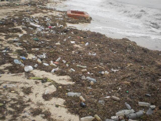
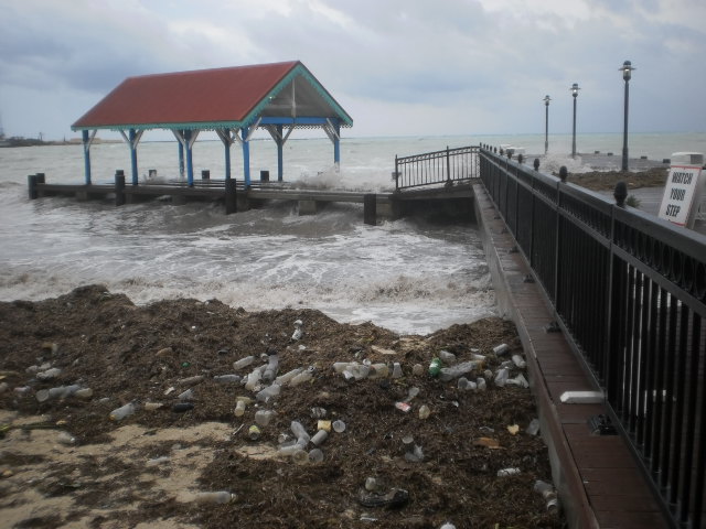
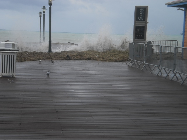
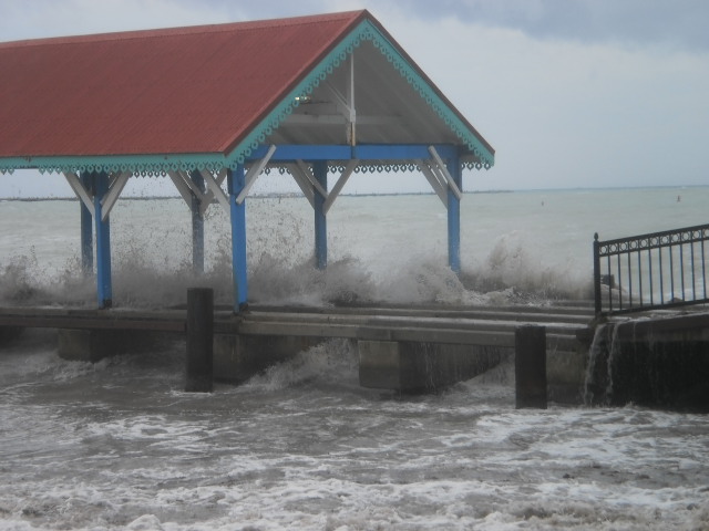
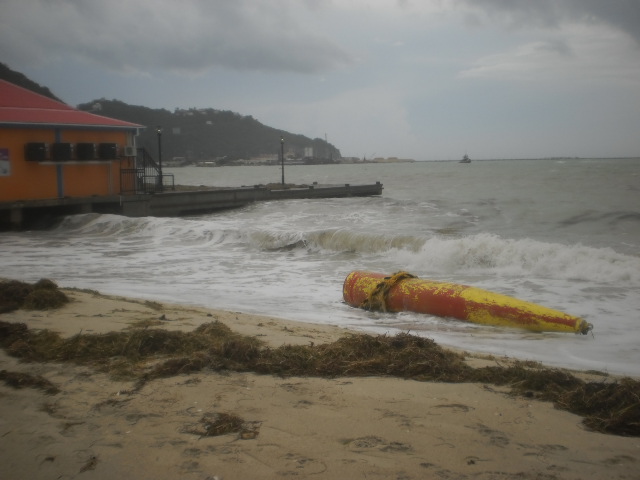
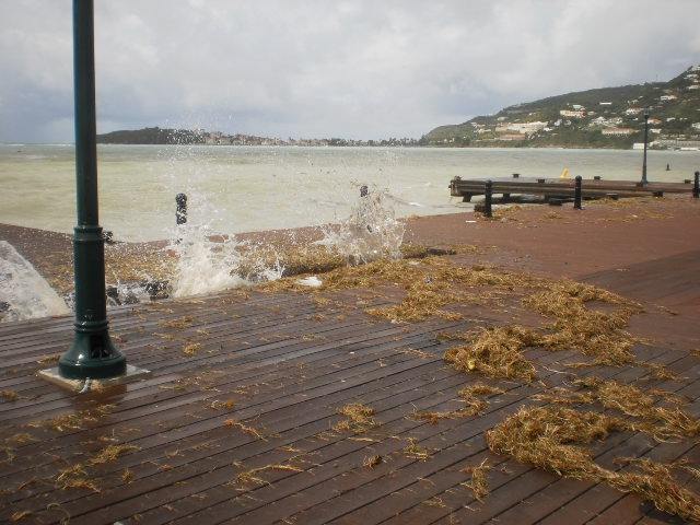
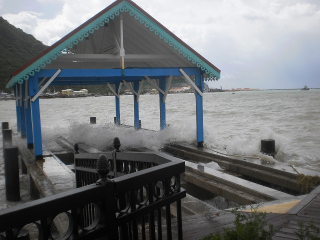
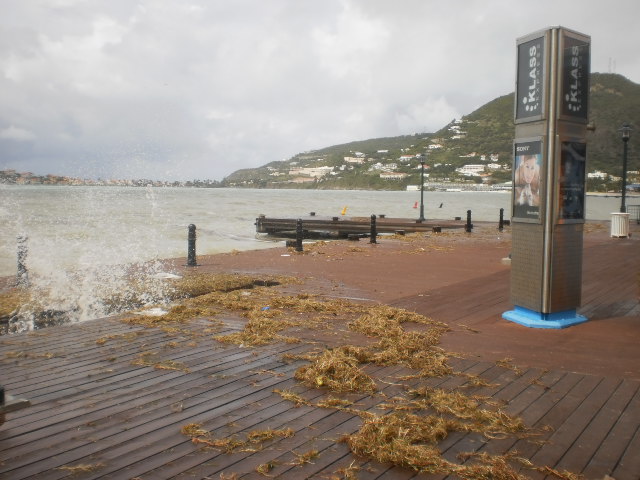
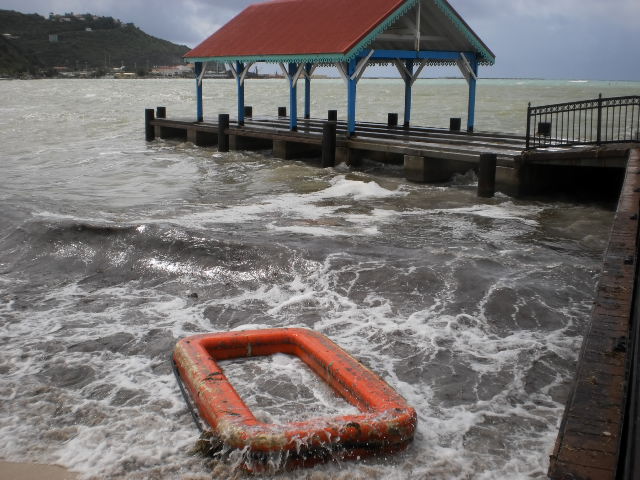
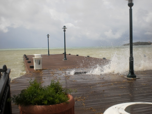
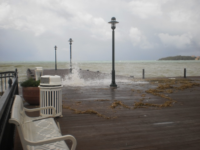
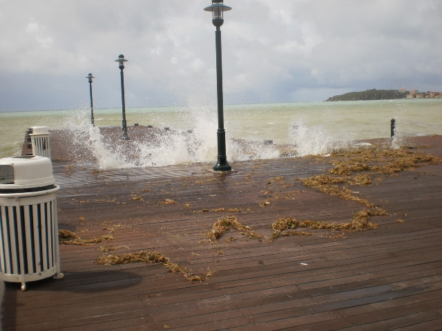
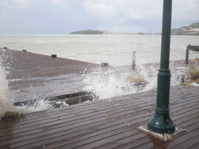
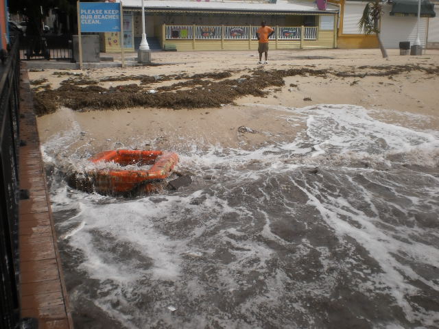
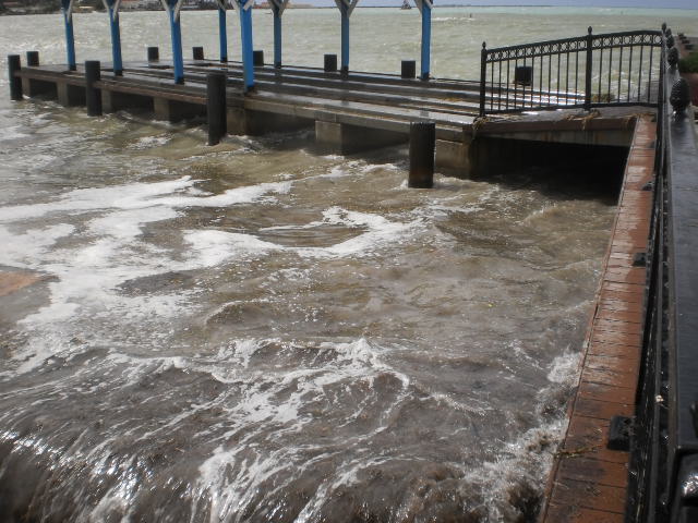
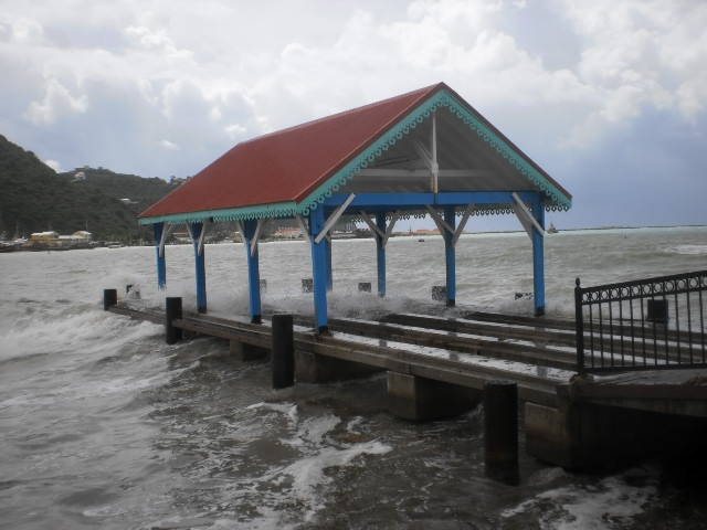
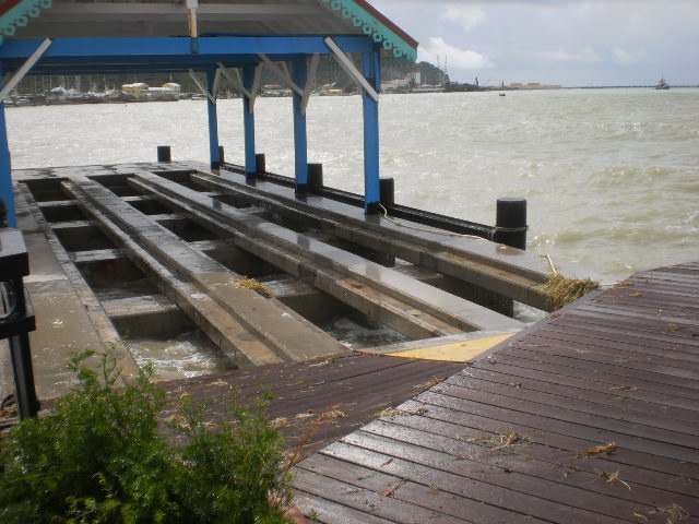
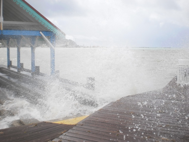
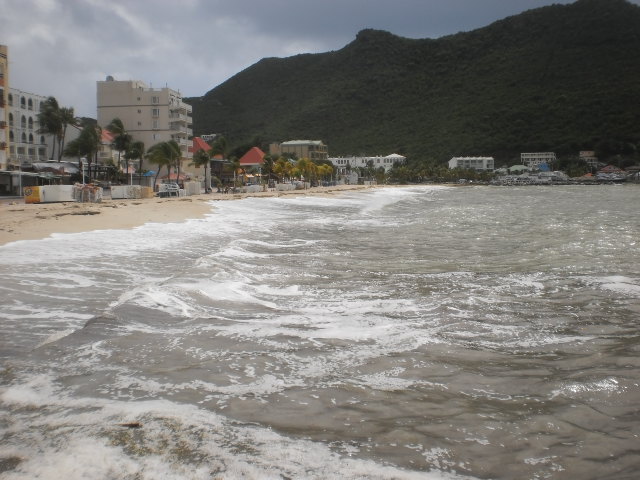
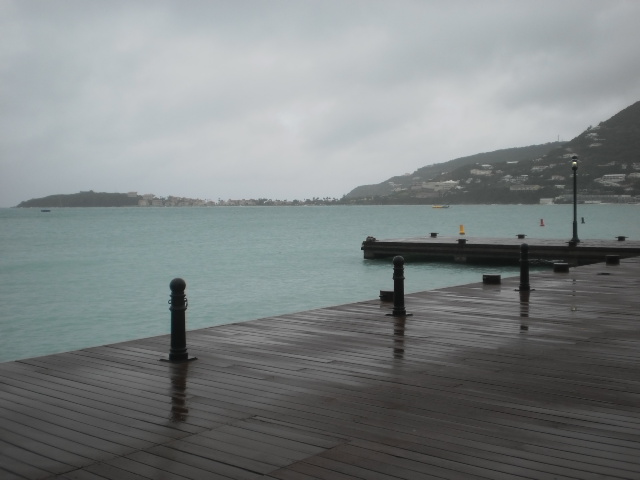
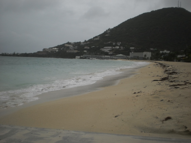
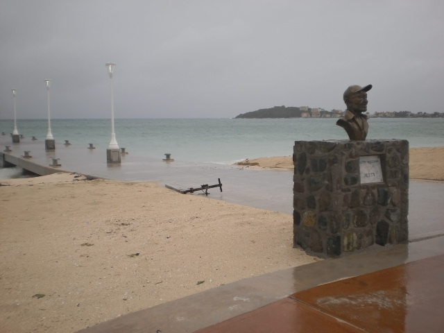
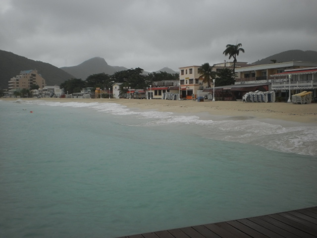
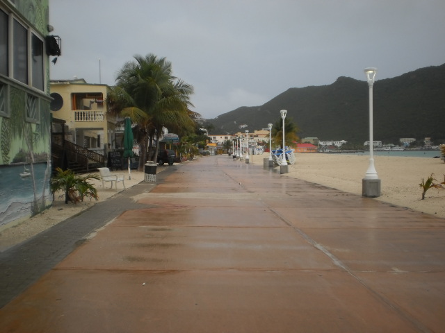
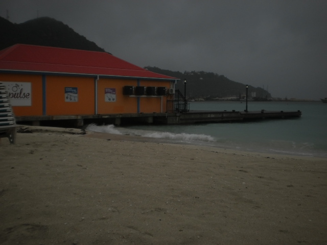
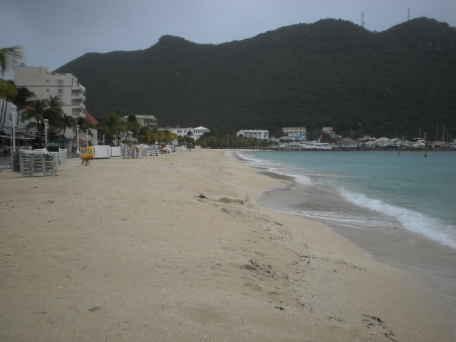
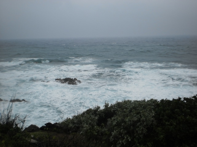
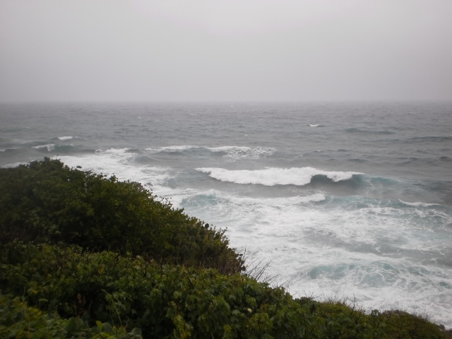
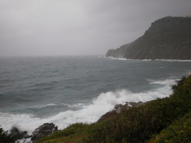
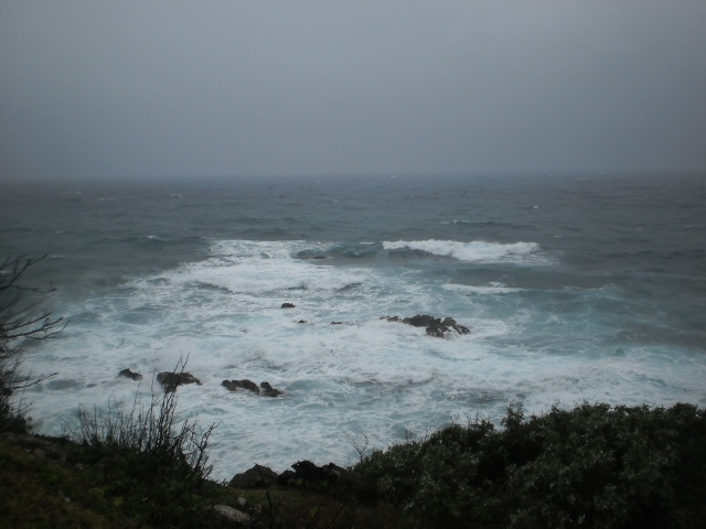
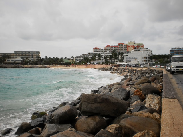
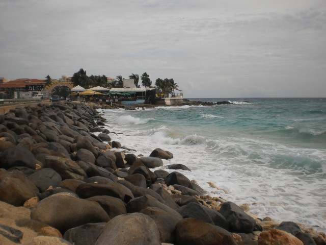
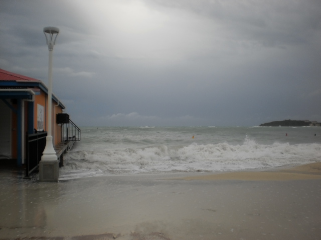
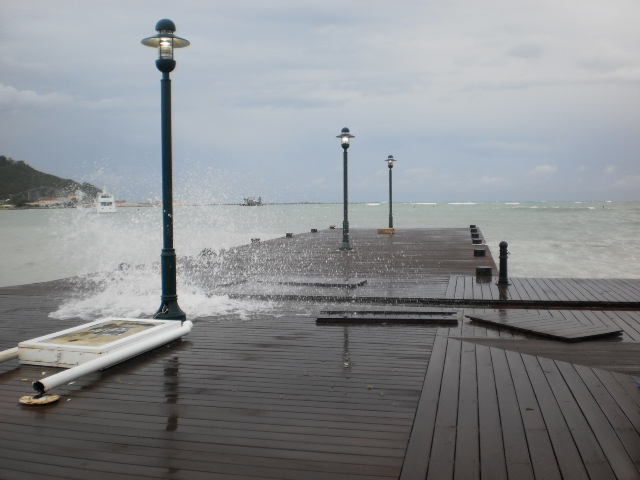
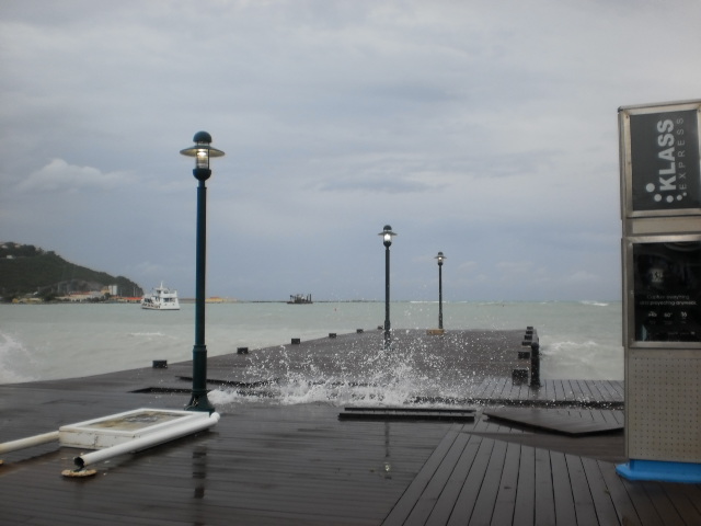
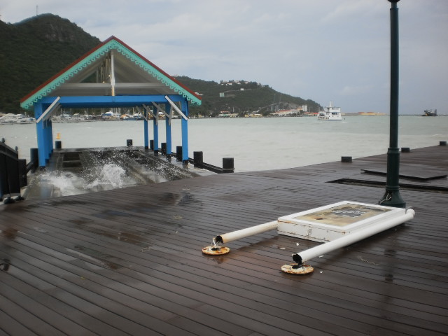
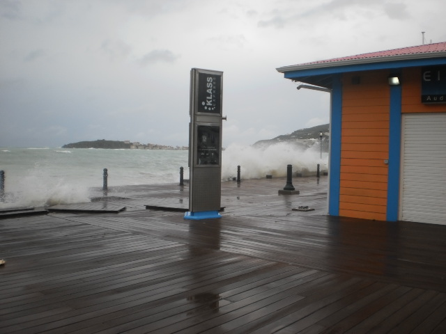
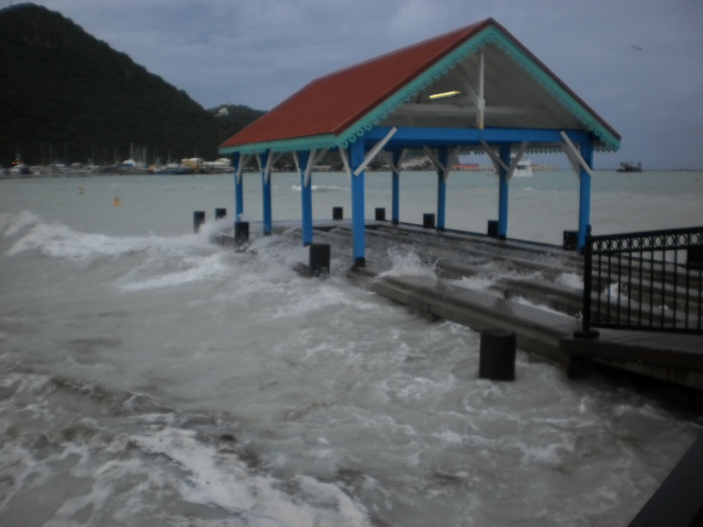
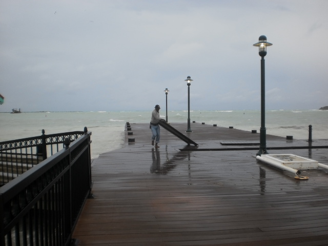
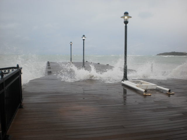
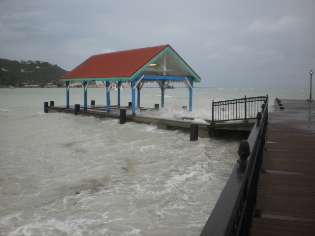
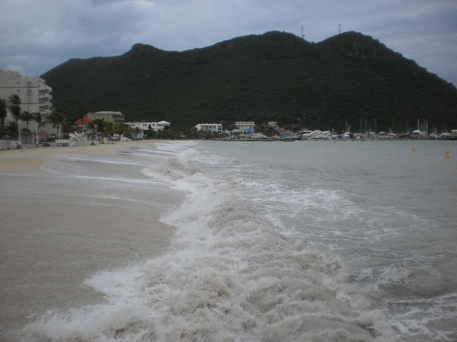
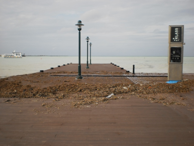
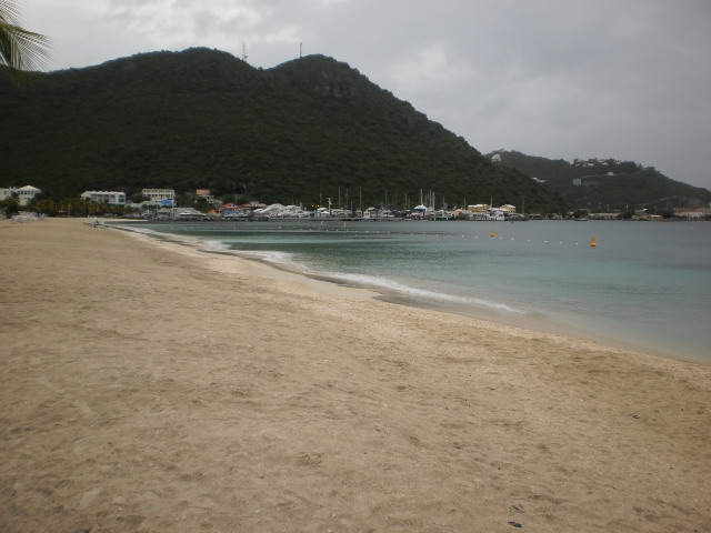
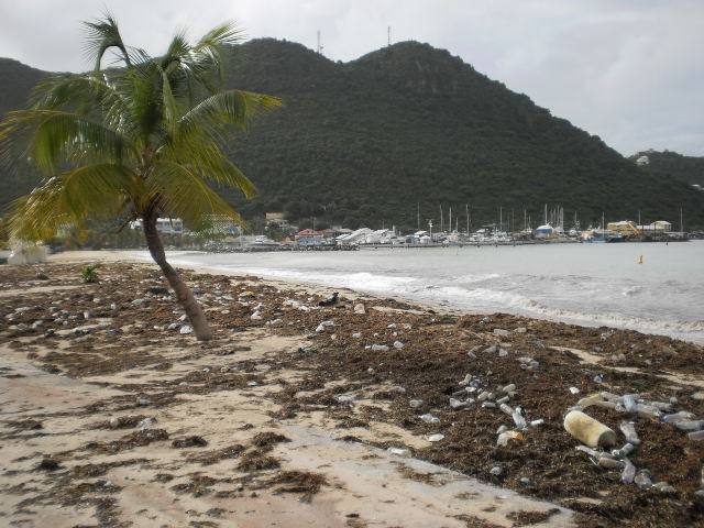