
|
- - - 2008 Hurricane Season - - -
|
- een afbeelding voor u
|
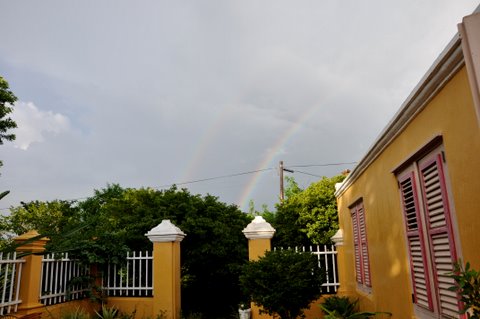
- From: "Bea Moedt" <beamoedt at scarlet.an>
- Date: Wed, 29 Oct 2008 07:37:51 -0400
|
Two rainbows
Attachment:
DSC_0181.jpg
Description: JPEG image
|
|
- bos ku wirlib banda di noordkant
|
- From: info at kunuku.net
- Date: 22 Oct 2008 17:10:45 -0000
|
http://www.StormCarib.com
20081022-1:09pm (UTC: 5:09pm)
Weather update for Curacao
Latitude: 12° 05'02.90"N
Longitude: 68°53'48.81"W
Report by: info -at- kunuku.net


PAPIAMENTU
Un tiki awaseru ta kai aworaki pero no na tur luga. Tambe tin bos i wirlib na
bandariba banda di noordkust. Laman tin golf di masomenos  un meter i mei i
bientu ta fo'i oost 11.5 mph / 18.5 km/h. Preshon ta 29.89 in / 1012 hPa.
Temperatura ta 88 °F / 31 °C .

ENGLISH
Light rain is falling here and there accompanied by lightning and thunder near
the north coast of Bandariba. The sea has 5ft waves and wind is coming from
east 11.5 mph / 18.5 km/h. Pressure is 29.89 in / 1012 hPa. Temperature is 88
°F / 31 °C .

NEDERLANDS (DUTCH)
Plaatselijke lichte regenbuien hier en daar en het bliksemt vooral op Bandariba
nabij de noordkust. De zee is matig met 1.5 m golven en wind komt uit de
oosterlijke richting 11.5 mph / 18.5 km/h. De barometer toont 29.89 in / 1012
hPa. Temperatuur is 88 °F / 31 °C .
|
|
- un tiki awaseru ta kai
|
- From: info at kunuku.net
- Date: 21 Oct 2008 16:11:30 -0000
|
|
http://www.StormCarib.com
20081021-12:05pm (UTC: 4:05pm)
Weather update for Curacao
Latitude: 12° 05'02.90"N
Longitude: 68°53'48.81"W
Report by: info -at- kunuku.net
PAPIAMENTU
Un tiki awaseru ta kai aworaki. Laman ta basta ketu i bientu ta fo'i oost 8.1 mph / 13.0 km/h. Preshon ta 29.92 in / 1013 hPa. Temperatura ta 87.8 °F / 31.0 °C.
ENGLISH
Light rain is falling here and there. The sea is calm and wind is coming from east 8.1 mph / 13.0 km/h. Pressure is 29.92 in / 1013 hPa. Temperature is 87.8 °F / 31.0 °C.
NEDERLANDS (DUTCH)
Het regent een klein beetje. De zee is rustig en wind komt uit de oosterlijke richting 8.1 mph / 13.0 km/h. De barometer toont 29.92 in / 1013 hPa. Temperatuur is 87.8 °F / 31.0 °C.

|
|
- hopi awaseru por jega mas tempran ku tabata kalkula
|
- From: info at kunuku.net
- Date: 19 Oct 2008 19:17:54 -0000
|
|
PAPIAMENTU
Birdman a informa nos ku atrobe awaseru i maltempu por jega mas tempran ku tabata kalkula. Entre kosta di Venezuela te ku 150 zeemijl fo'i kosta di Venezuela e islanan ABC tin chens pa risibi bastante awaseru. Sabiendo esaki por fabor tene kwenta ku bo bestianan di kas i den kura i nos grandinan ku no por kana bon.
ENGLISH
tropical wave moving W 10-15 KT. Scattered moderate to strong rainshowers are possible between the coast of Venezuela and up to 150 nautical miles offshore of the coast of Venezuela. The ABC islands are within this area
NEDERLANDS (DUTCH)
plaatselijke regenbuien zijn mogelijk in een gebied vanaf de kust van venezuela tot ongeveer 150 zeemijl buiten de Venezolaanse kust. De ABC eilanden liggen in dit gebied. Regen zal matig tot sterk zijn...
bron: NHC forecast op http://stormcarib.com/tropdisc.htm

|
|
- light thunderstorms moving in from SW
|
- From: help at curacaowildlife.com
- Date: 17 Oct 2008 04:14:49 -0000
|
http://Stormcarib.com
20081017_12:13hrs am (UTC 4:13hrs am)
Weather update for Curacao, DUTCH ANTILLES.
Latitude: 12° 9'8.93"N
Longitude: 68°53'44.61"W
Report by: Marcus DeMaaijer (help -at- curacaowildlife.com)
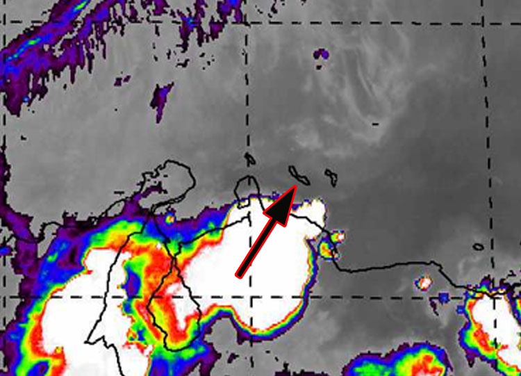
Currently Curacao is experiencing a wave of light to medium thunderstorms arriving from the SW from Venezuela. See satellite image below. Light rain is currently falling in Bandariba. Since large areas of Bandabou are still without power and phone service it is not fully operational either in the areas of the Turtle Nest Hathings... it is not possible to find out from the Curacao Wildlife volunteers in that area what their weather experience is at this moment.
In regards to my post on the 15th.... you should read this
http://www.amigoe.com/artman/publish/artikel_48018.
php
Godspeed to all in the Caribbean.
| |
|
|
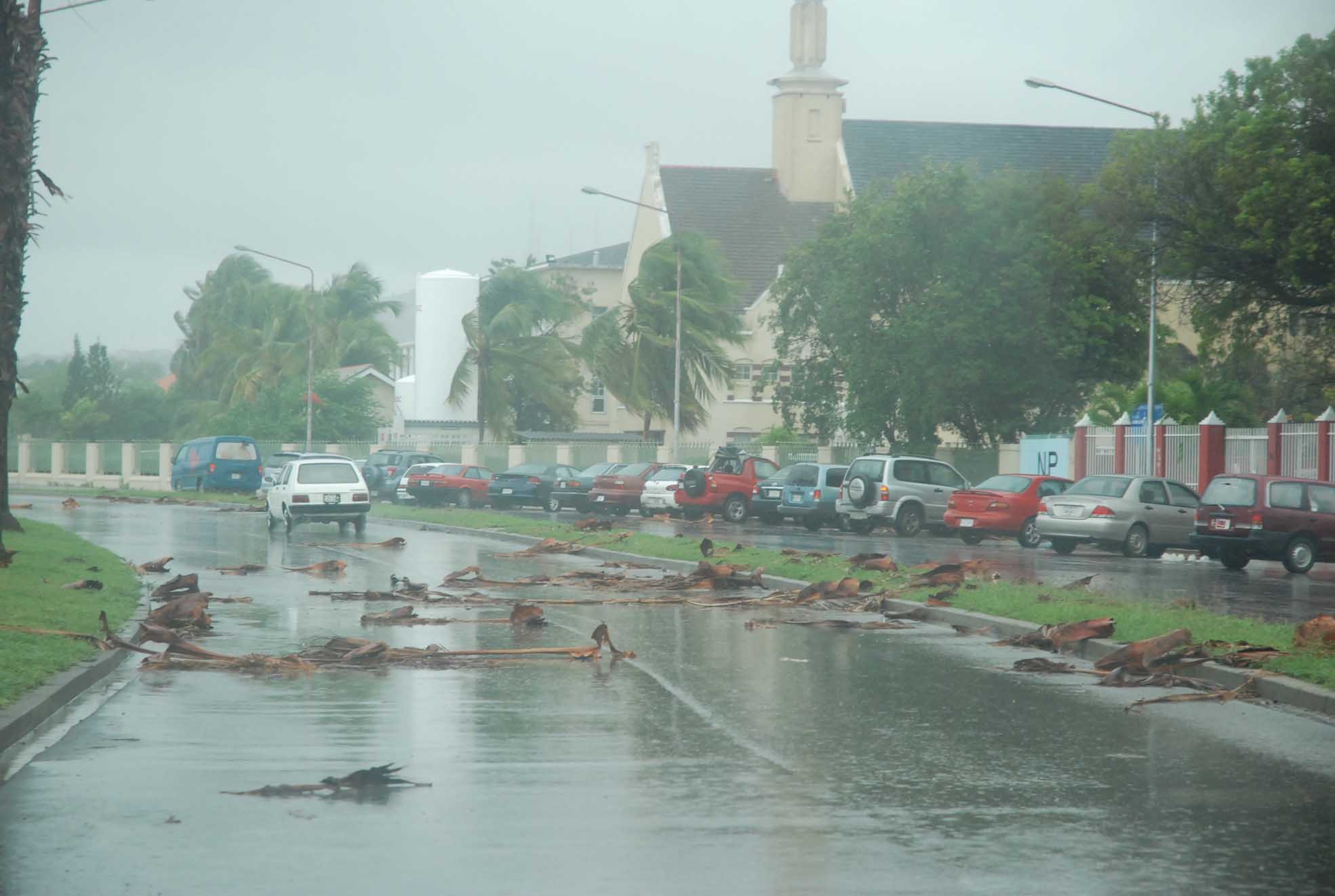
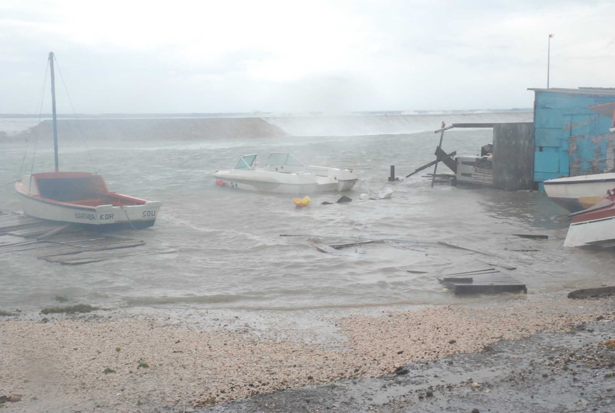
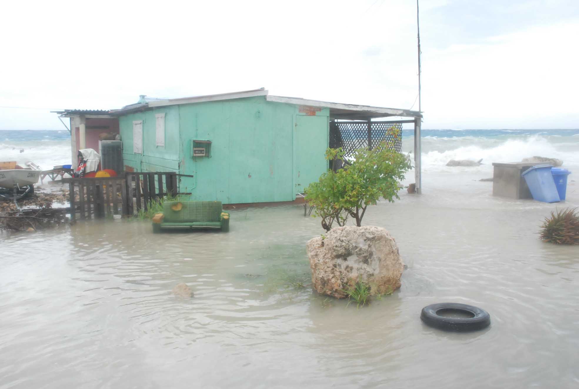
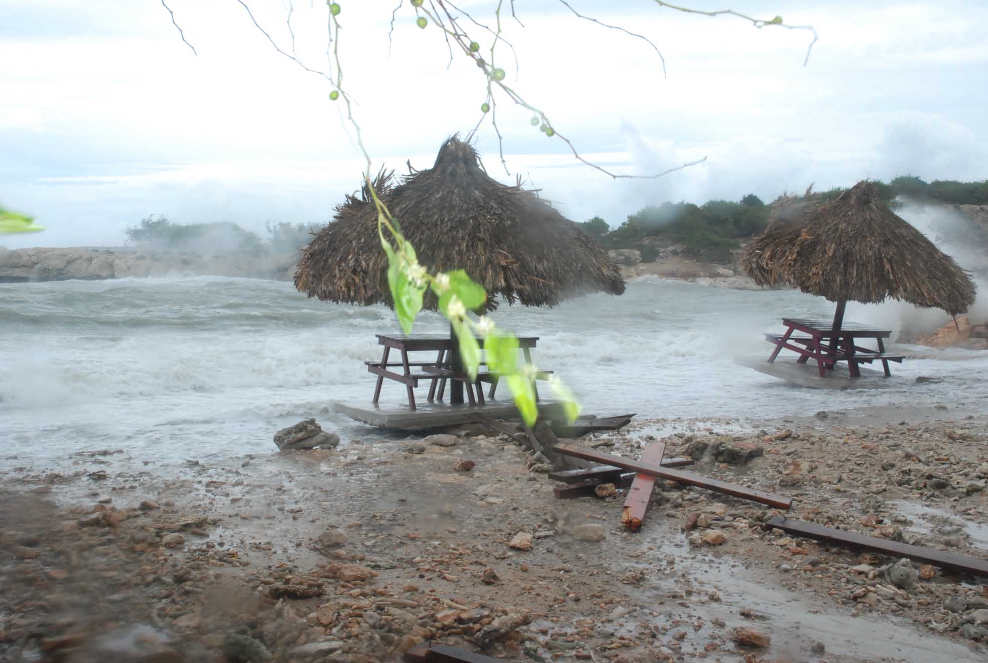
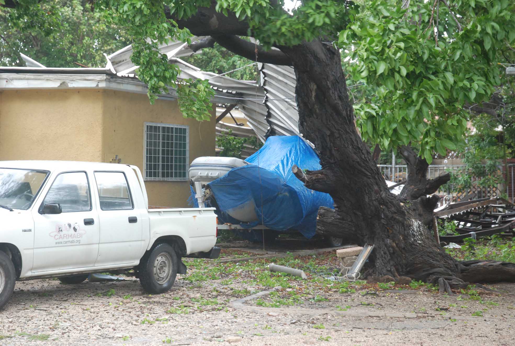
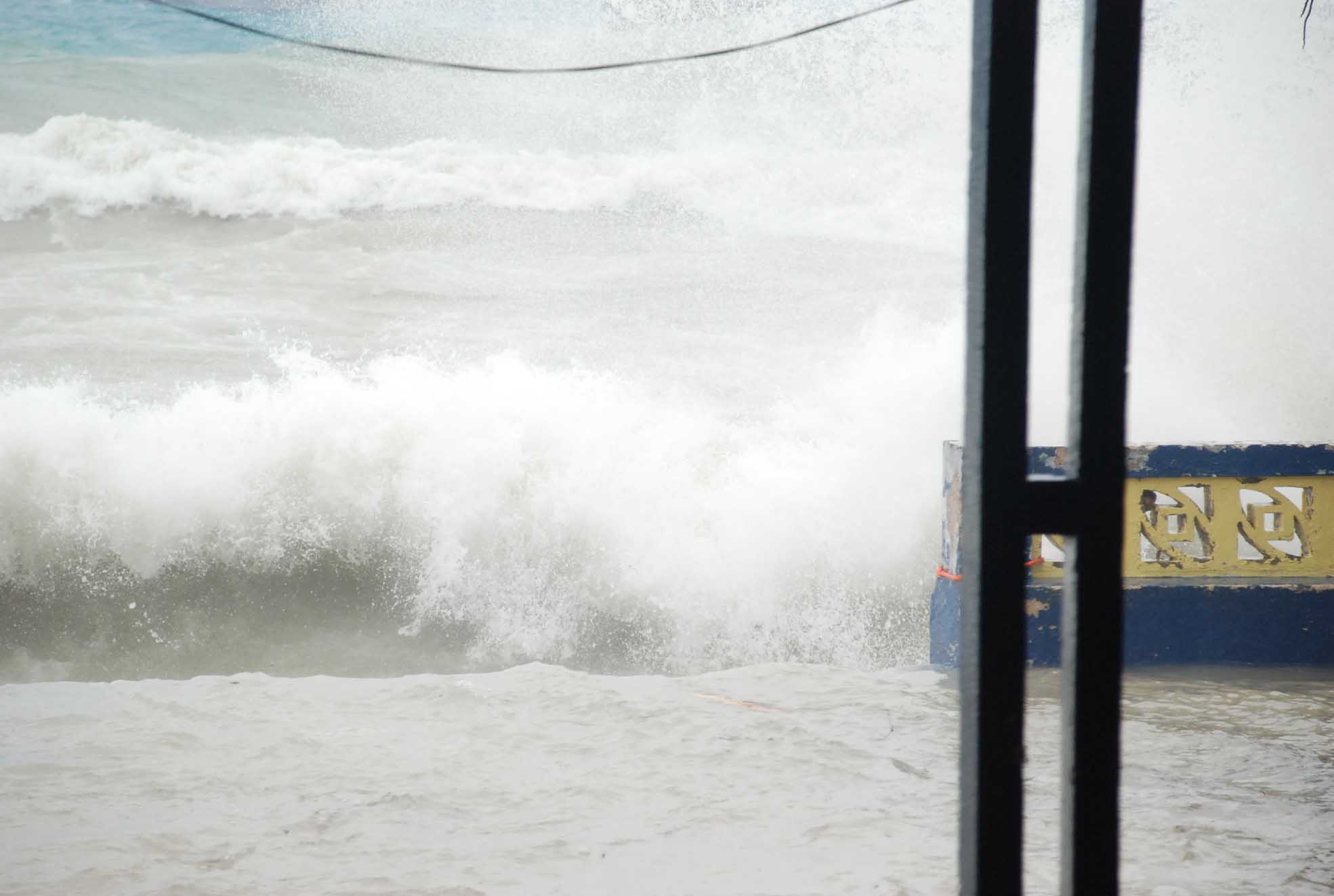
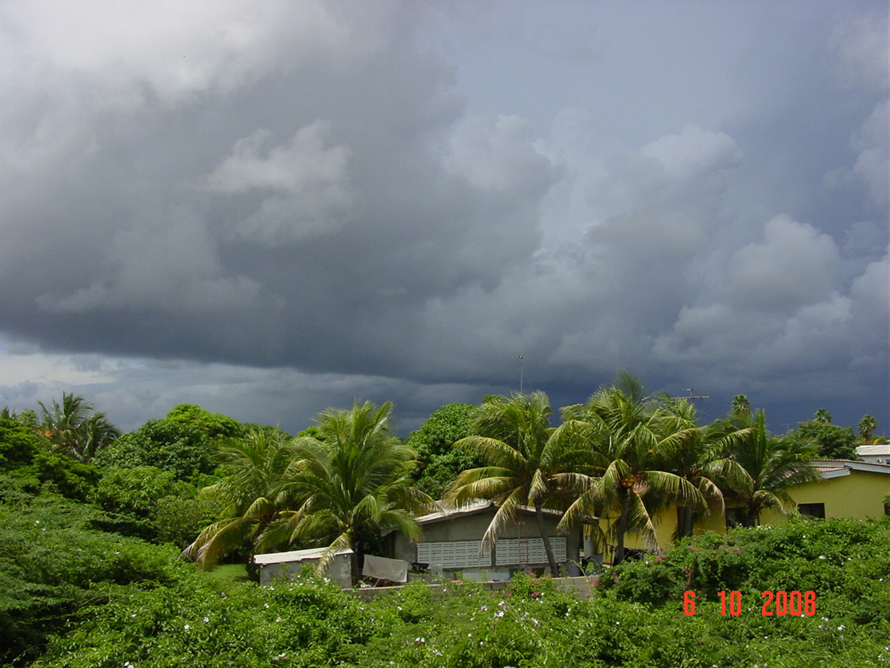
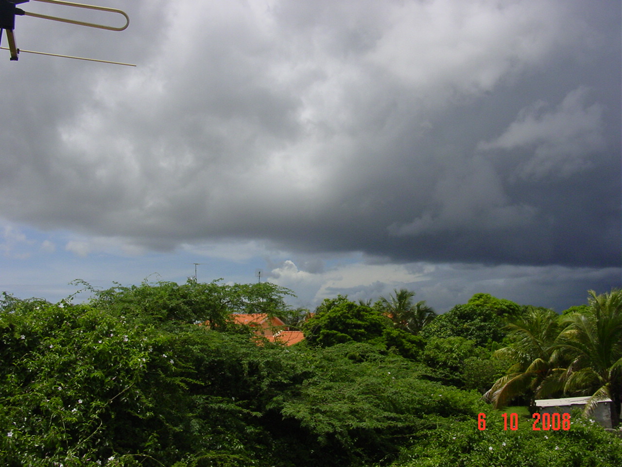
- some pics of effect omar
|
- From: Robert Candelaria <robertcandelaria at rocketmail.com>
- Date: Wed, 15 Oct 2008 20:05:10 -0700 (PDT)
|
yesterday we experienced some effect of tropical storm omar that approached our island at about 165 km
we're not accustom with such kind of weather, so it really scare us somewhat
thanks God today it left
God spare those that will be hit
stay safe
attached you'll see some pics
robby
|
Attachment:
DSC_0204.JPG
Description: JPEG image
Attachment:
DSC_0210.JPG
Description: JPEG image
Attachment:
DSC_0214.JPG
Description: JPEG image
Attachment:
DSC_0217.JPG
Description: JPEG image
Attachment:
DSC_0222.JPG
Description: JPEG image
Attachment:
DSC_0227.JPG
Description: JPEG image
Attachment:
DSC_0234.JPG
Description: JPEG image
Attachment:
DSC_0235.JPG
Description: JPEG image
Attachment:
DSC_0248.JPG
Description: JPEG image
Attachment:
DSC_0251.JPG
Description: JPEG image
Attachment:
IMGP0027.JPG
Description: JPEG image
Attachment:
IMGP0028.JPG
Description: JPEG image
|
|
- OMAR UPDATE
|
- From: help at curacaowildlife.com
- Date: 15 Oct 2008 20:35:22 -0000
|
http://Stormcarib.com
20081015-4:30pm (UTC: 8:30pm)
Weather update for Curacao
Latitude: 12° 9'8.93"N
Longitude: 68°53'44.61"W
Report by: Marcus DeMaaijer (help -at- curacaowildlife.com)
CURRENT CONDITIONS IN CURACAO AND IMPORTANT PHONE NUMBERS
ELECTRICTY
Powerlines have been fixed and uprooted trees have been removed.
Smashed power poles are being replaced.
If you still see powerlines emitting sparks, please call 911 to alert the
police and the fire brigade.
TRAFFIC LIGHTS UPDATE
The traffic lights at Centrum Mahaai and at the Church of Janwe are not
functioning, but traffic police are guiding traffic during times of high
traffic congestion.
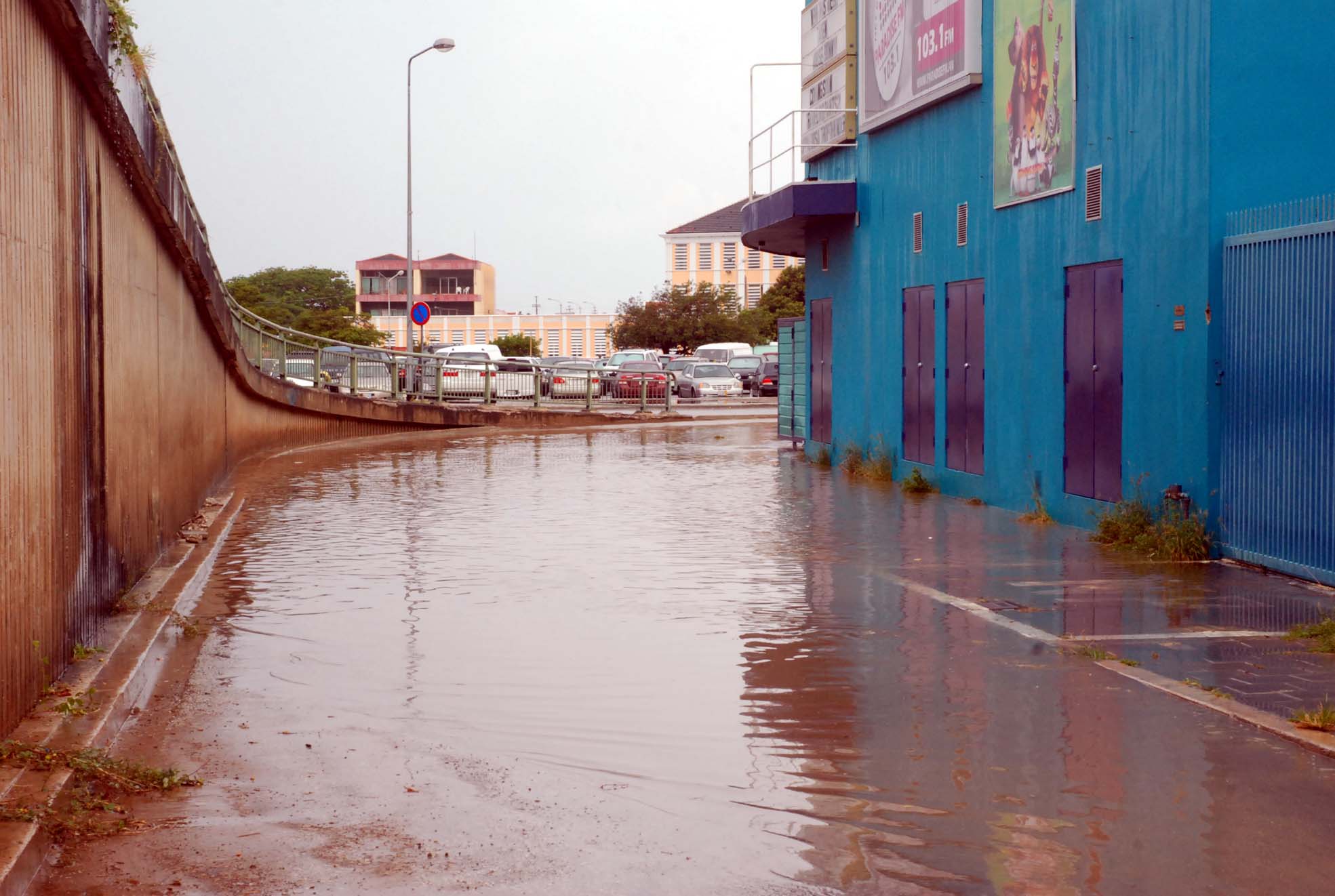
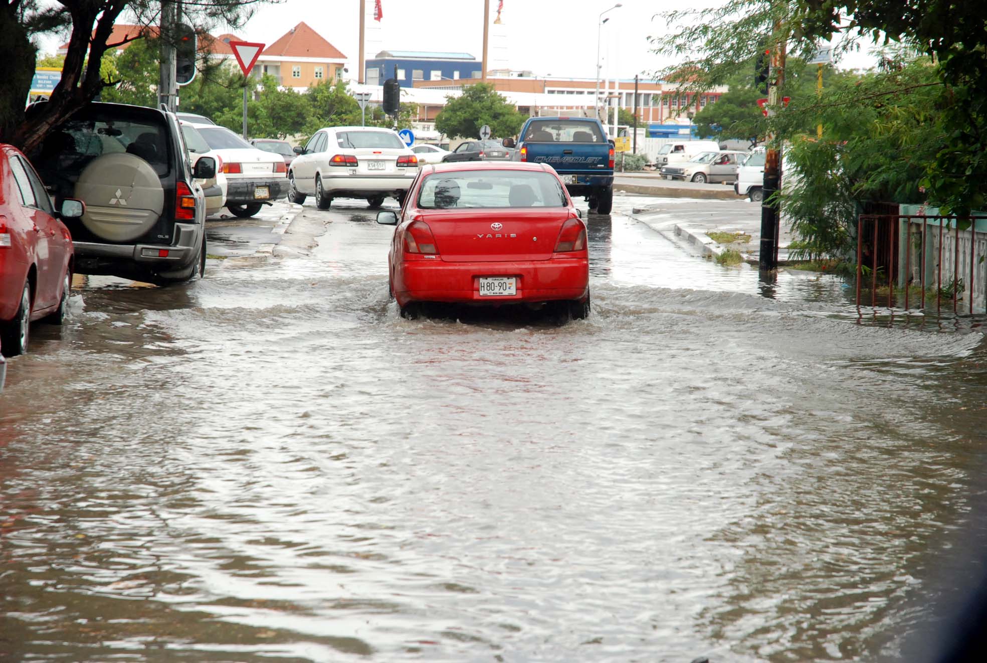
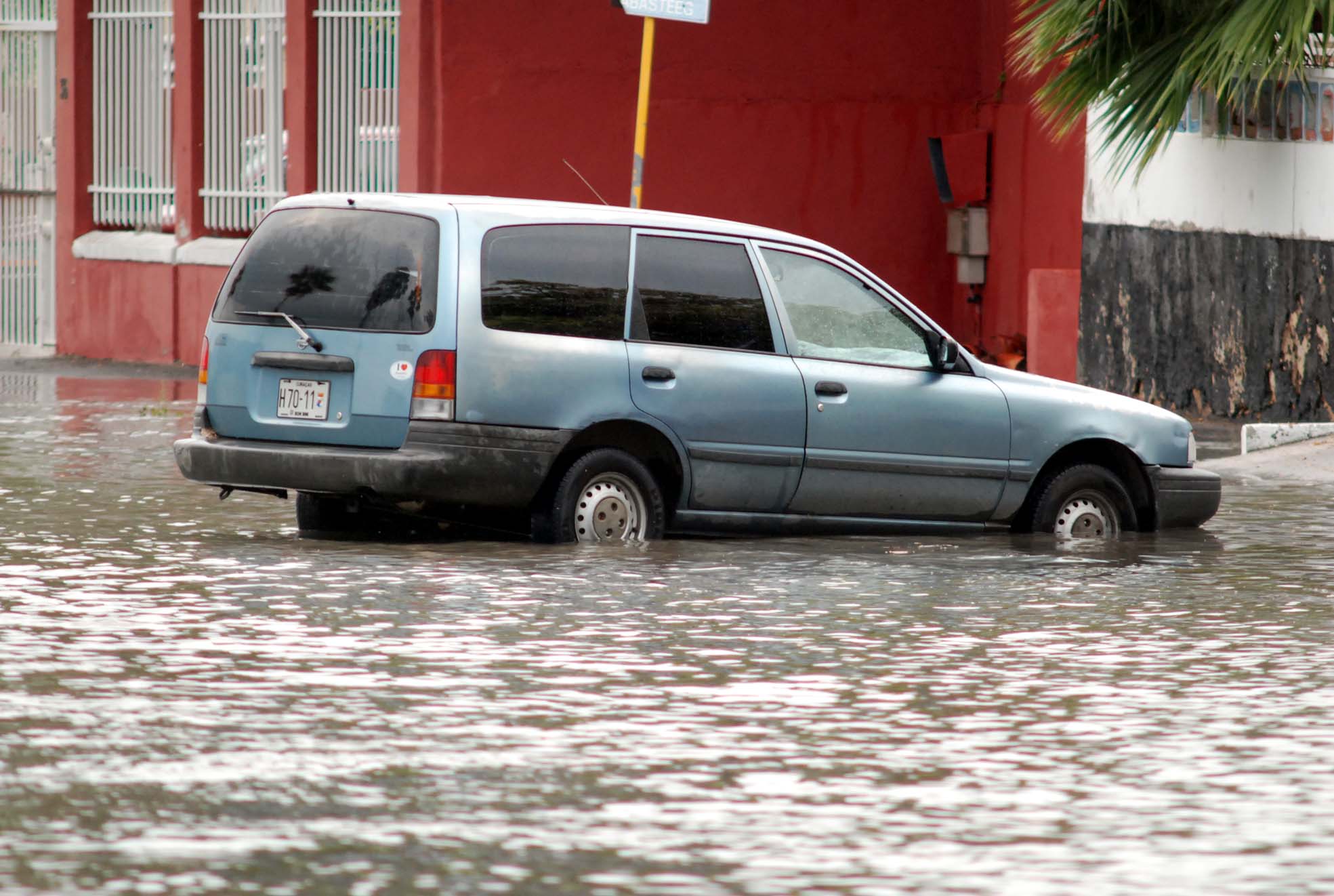
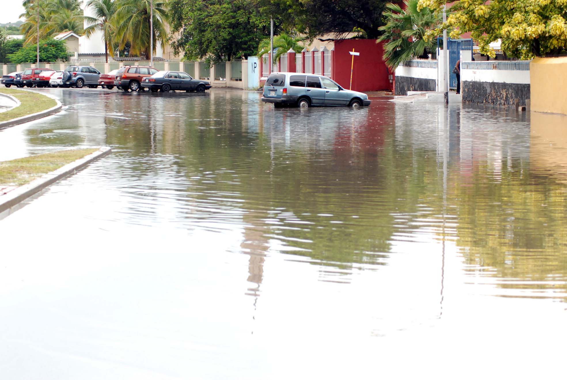
ROADS UPDATE
Floaded roads at:
Emancipatie Boulevard,
Dr. Martin King Blvd,
all roads in Damacor near the Zoo,
some deep puddles at Kaya di Steenrijk
Marie Pompoen
Penstraat
WILDLIFE UPDATE:
Please check cattle and other farm animals for injuries.
Make sure that they have enough FRESH water and DRY food.
Don't forget about your caged farm animals and housepets.
For Emergencies with farm animals and domesticated pets you can call:
Animal Care Center 738-4422
Veterinarian Doest 868-2621
Ronde Klip 737-2185
Tera Cora 864- 9569
Vredenberg 465-3033
Dierenbescherming 465-4300
For Emergencies with wild animals you can call:
Wild Animal Rescue Curacao Wildlife : 6683500
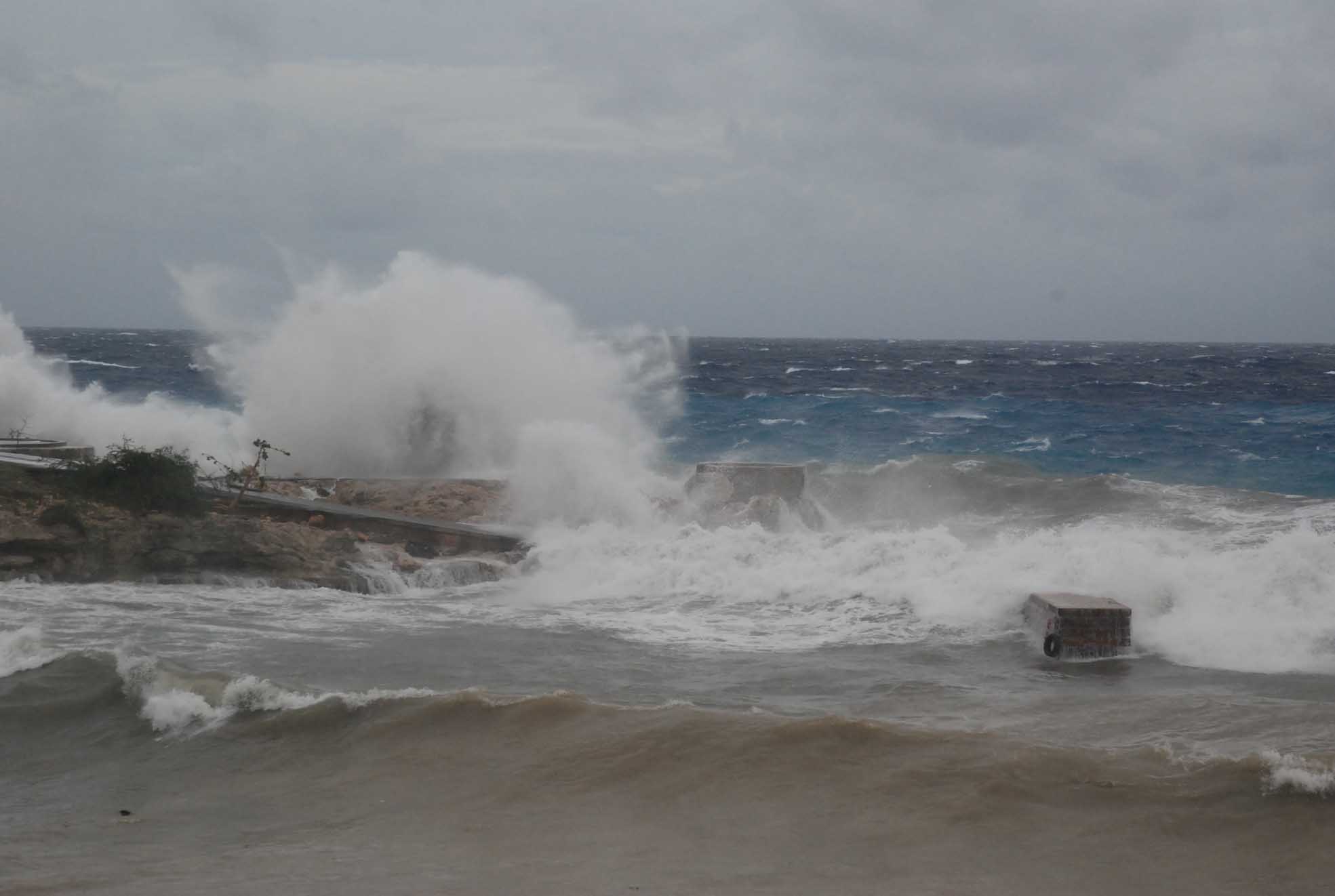
MARINE UPDATE
5 to 7 feet waves coming from the south west are still affecting the southern
shoreline of Curacao. Boaters are still advised NOT to head out to sea and to
take the boats out of the water if possible, or find shelter inside Schottegat,
Piscadera, Spaanse Water, and St.Joris bays.
WIND UPDATE
Wind is clocked at the southern coastline at 15 km/h with windgusts to 35 km/h.
RAIN UPDATE
Light rain is coming down in Bandabou and at Bandariba.
PICTURES AND VIDEO
http://www.versgeperst.com/?p=401
http://www.versgeperst.com/?p=391
Godspeed to all of us in Curacao, Bonaire, Aruba, St.Maarten, Saba,
St.Eustatius, the other islands in the Caribbean and everyone on the
surrounding mainland.
|
|
- Important phone numbers...!!
|
- From: help at curacaowildlife.com
- Date: 15 Oct 2008 14:58:17 -0000
|
http://Stormcarib.com
20081015-10:55am (UTC: 2:55pm)
Weather update for Curacao
Latitude: 12° 9'8.93"N
Longitude: 68°53'44.61"W
Report by: Marcus DeMaaijer (help -at- curacaowildlife.com)

CURRENT CONDITIONS IN CURACAO AND IMPORTANT PHONE NUMBERS

Fire Brigade and police 911
Coastguard 913
CEMS 912

ELECTRICTY
Powerlines have been downed by broken treelimbs and uprooted trees.
Due to traffic accidents some powerline poles have been smashed.
When powerlines emit sparks it must be reported to the police 911 and
Aqualectra and the fire brigade at 911.

TRAFFIC LIGHTS UPDATE
The traffic lights at Centrum Mahaai and at the Church of Janwe have ceased to
function.


ROADS UPDATE

Floaded roads and stalled cars blocking roads at:

Emancipatie Boulevard,
Dr. Martin King Blvd,
Schottegatweg Ring,
Roodeweg,
all roads in Damacor near the Zoo,
Otrobanda centrum,
Punda
Kaminda di Brievengat,
Kaya di Steenrijk
Marie Pompoen
Penstraat
Scharloo

WILDLIFE UPDATE:
Please take cattle and other farm anilas to higher ground.
Don't forget about your caged farm animals and housepets.

For Emergencies with farm animals and domesticated pets you can call:
Animal Care Center 738-4422
Veterinarian Doest 868-2621
Ronde Klip 737-2185
Tera Cora 864- 9569
Vredenberg 465-3033
Dierenbescherming 465-4300

For Emergencies with wild animals you can call:
Wild Animal Rescue Curacao Wildlife : 6683500

MARINE UPDATE
8 to 11 feet waves coming from the south west is affecting the southern
shoreline of Curacao. Boaters are not advised to head out to sea and to take
the boats out of the water if possible, or find shelter inside Schottegat,
Piscadera, Spaanse Water, and St.Joris bays. For Emergencies call the
coastguard at 913

WIND UPDATE
Wind is clocked at the southern coastline at 60 km/h with windgusts to  85 km/h.

RAIN UPDATE
Light to moderate rain is coming down at a rate of 2 to 4 inches per hour in
Bandabou and at a rate of 1 to 2 inches per hour at Bandariba.


Godspeed to all of us in Curacao, Bonaire, Aruba, the Caribbean and on the
surrounding mainland.
|
|
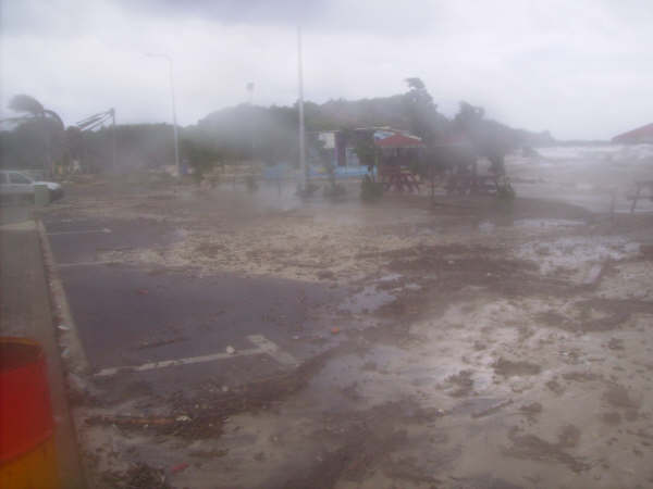
- Omar update for Curacao
|
- From: help at curacaowildlife.com
- Date: 15 Oct 2008 14:18:20 -0000
|
http://Stormcarib.com
20081015-10:15am (UTC: 2:15pm)
Weather update for Curacao
Latitude: 12° 9'8.93"N
Longitude: 68°53'44.61"W
Report by: Marcus DeMaaijer (help -at- curacaowildlife.com)


Moving on........

CURRENT WEATHER IN CURACAO

MARINE
Seven to 10 feet waves coming from the south west is affecting the southern
shoreline of Curacao. Boaters are not advised to head out to sea and to take
the boats out of the water if possible, or find shelter inside Schottegat,
Piscadera, Spaanse Water, and St.Joris bays.

WIND
Wind is clocked at the souther shore at 55 km/h with windgusts to  80 km/h.

RAIN
The skies have opened up and heavy rain is coming down at a rate of 8 inches
per hour.

ELECTRICTY
Powerlines have been downed by broken treelimbs and uprooted trees. Due to
traffic accidents some powerline poles have been smashed.

TRAFFIC LIGHTS
The traffic lights at Centrum Mahaai and at the Church of Janwe have ceased to
function.

ROADS
The roads at Emacipatie Boulevard, and Dr. Martin King Blvd, and at
Schottegatweg North, East, and South have floaded. Drivers are advised not to
drive here due to floaded cars blocking the roads.

Godspeed to all of us in Curacao, Bonaire, Aruba, the Caribbean and on the
surrounding mainland.
|
|
- Emailing: MOV00143
|
- From: "Bea Moedt" <beamoedt at scarlet.an>
- Date: Tue, 14 Oct 2008 16:36:56 -0400
|
Handelskade
Attachment:
MOV00143.MPG
Description: MPEG movie
|
|
- Emailing: MOV00117
|
- From: "Bea Moedt" <beamoedt at scarlet.an>
- Date: Tue, 14 Oct 2008 16:14:50 -0400
|
Marie Pompoen
Attachment:
MOV00117.MPG
Description: MPEG movie
|
|
- Emailing: MOV00129
|
- From: "Bea Moedt" <beamoedt at scarlet.an>
- Date: Tue, 14 Oct 2008 16:14:50 -0400
|
Beach of Lions Dive Hotel
Attachment:
MOV00129.MPG
Description: MPEG movie
|
|
- Emailing: MOV00111
|
- From: "Bea Moedt" <beamoedt at scarlet.an>
- Date: Tue, 14 Oct 2008 15:50:36 -0400
|
Penstraat
Attachment:
MOV00111.MPG
Description: MPEG movie
|
|
- Emailing: MOV00136
|
- From: "Bea Moedt" <beamoedt at scarlet.an>
- Date: Tue, 14 Oct 2008 15:33:49 -0400
|
Handelskade
Attachment:
MOV00136.MPG
Description: MPEG movie
|
|
- Emailing: MOV00126
|
- From: "Bea Moedt" <beamoedt at scarlet.an>
- Date: Tue, 14 Oct 2008 15:25:59 -0400
|
Lions Dive Hotel
Attachment:
MOV00126.MPG
Description: MPEG movie
|
|
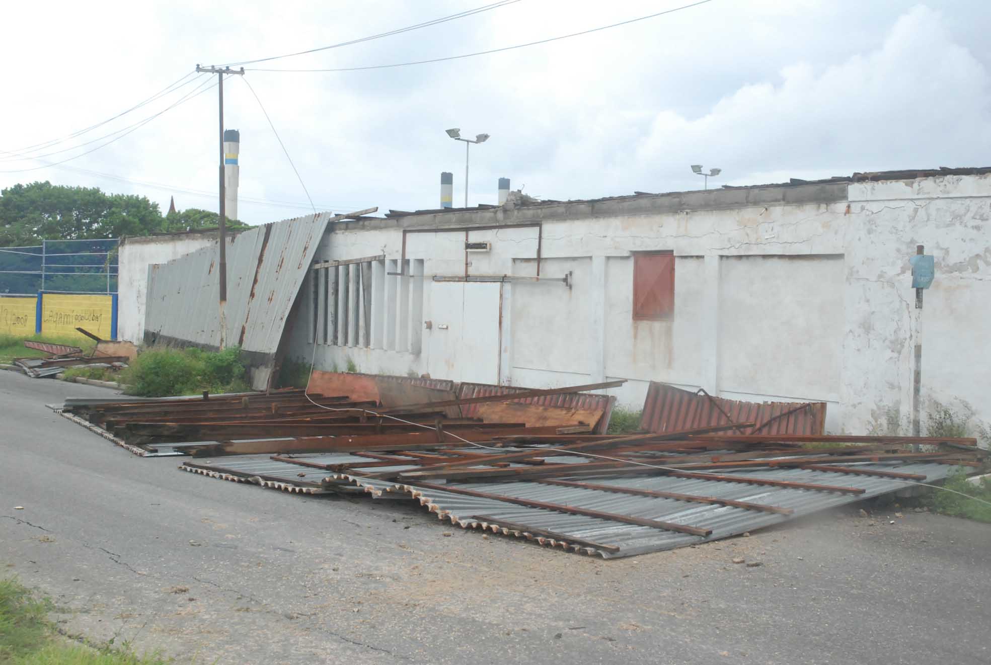
- tropical storm omar....
|
- From: help at curacaowildlife.com
- Date: 14 Oct 2008 15:22:32 -0000
|
http://Stormcarib.com
20081014-11:20am (UTC: 3:20pm)
Weather update for Curacao
Latitude: 12° 9'8.93"N
Longitude: 68°53'44.61"W
Report by: Marcus DeMaaijer (help -at- curacaowildlife.com)
Omar did a sneak attack and dipped south at 1 am today when everyone was
snoozing. I myself got stuck in traffic and was rescued by the RoadWatch aka
"de wegenwacht". Currently we are clocking windgusts up to 115 Km/h with huge
sea waves coming in from the south west. Rain accumulationwas measured at 84 mm
at 730am in Schelpwijk. Rain measurements in other areas will be posted as they
become known. In Bandariba there is a light downpour and at Banda Bou the rain
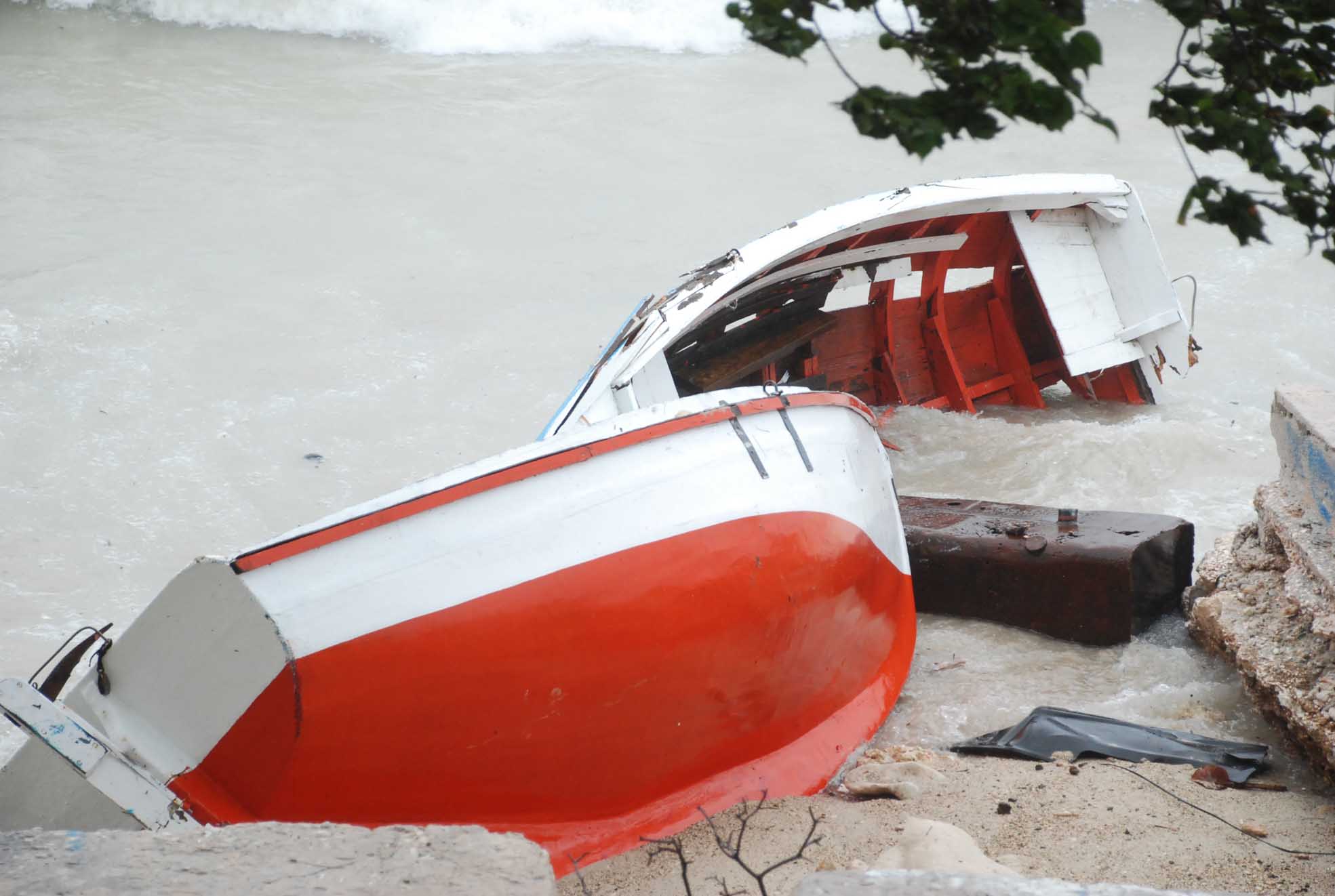
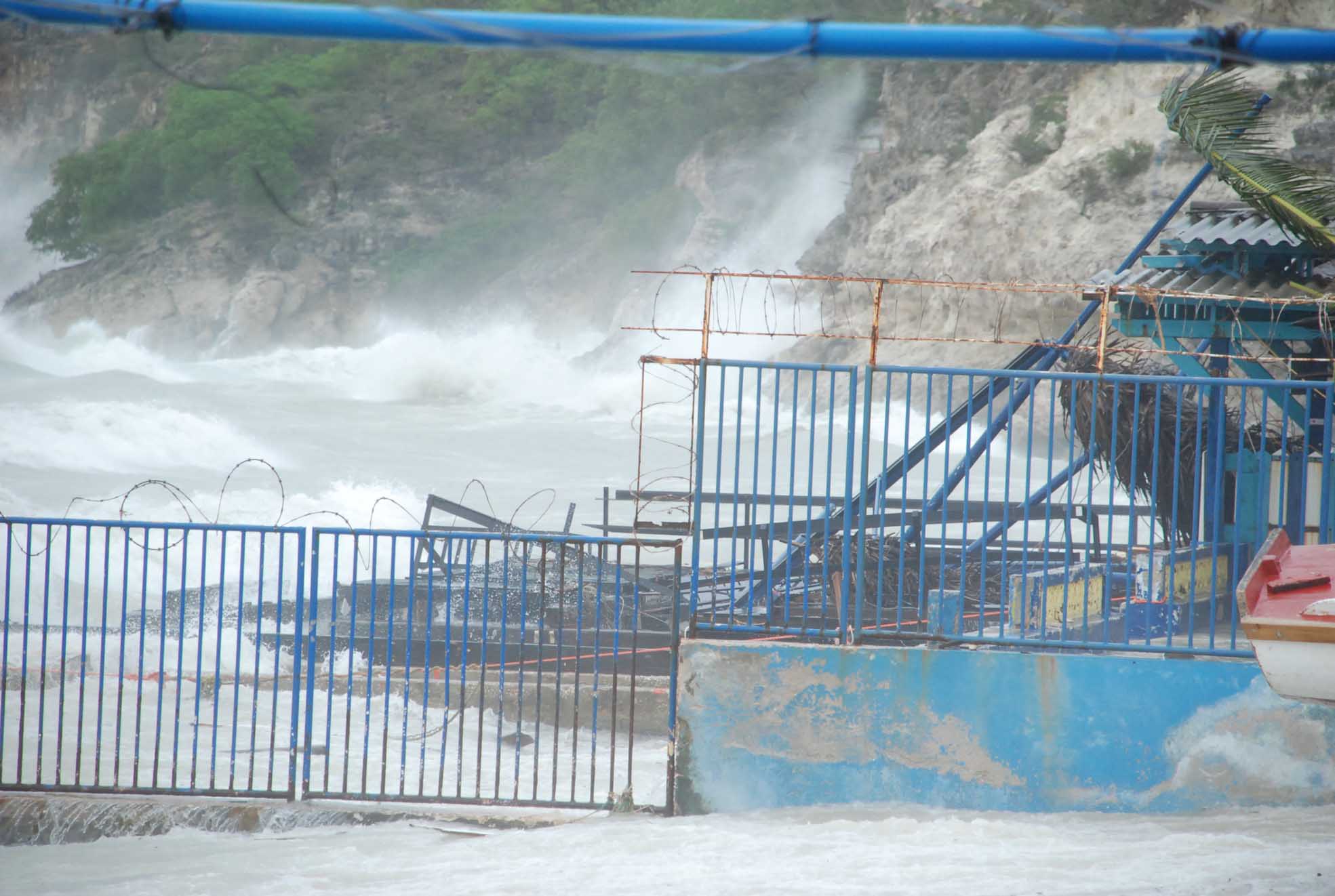
is moderate to heavy. Reports from local fishermen indicate that the piers at
the hotels have sustained significant damage.
The pontoon bridge between Punda and Otrobanda has been safely towed into the
harbour and sustained minimal to no damage. People are asked to remain inside
as their are many downed powerlines and trees have been uprooted.
+++++==the NHC forecast is as follows:
At 1100 am AST...1500z...the center of Tropical Storm Omar was located by
satellite and radar data from Curacao to be near latitude 14.0
north...longitude 69.0 west or about 355 miles...570 km...south-southwest of
San Juan Puerto Rico and about 125 miles...200 km...north of Curacao.
Omar is moving toward the east-southeast near 2 mph...4 km/hr. A gradual turn
to the east and then northeast is forecast today...with a slow increase in
forward speed expected on Wednesday.
Maximum sustained winds are near 40 mph...65 km/hr. Gradual strengthening is
forecast over the next 48 hours.
Tropical storm force winds extend outward up to 70 miles... 110 km...mainly
east through south of the center.
The estimated minimum central pressure is 1001 mb...29.56 inches.
Omar may produce total rainfall amounts of 4 to 8 inches over portions of the
Netherlands Antilles...with maximum amounts of 12 inches possible. Rainfall
amounts of 2 to 4 inches with maximum amounts of 6 inches are possible across
extreme northwestern and north central Venezuela and the northern Guajira
Peninsula. These rains could produce life-threatening flash floods and mud
slides.
Repeating the 1100 am AST position...14.0 N...69.0 W. Movement
toward...east-southeast near 2 mph. Maximum sustained winds...40 mph. Minimum
central pressure...1001 mb.
+++++++
Godspeed to all of us in Curacao, Aruba, Bonaire, the Caribbean and on the
surrounding mainland.
|
|
- rain rain and more rain
|
- From: Robert Candelaria <robertcandelaria at rocketmail.com>
- Date: Tue, 14 Oct 2008 07:18:32 -0700 (PDT)
|
yesterday it started in the night with lightning, thunder and a lot of rain when the south part of the tropical depression 15 touch our island at the north side
the wind picked up a little and so it continue during the night
this morning we have a lot of rain and wind but thunder and lightning stayed out for a while
the see is a little rough and some beaches and boats suffered damages
trees fall down and there are floodings over the island
long we were waiting for some rain so now we can see forward to a green island for some time
robby
|
|
|
- bastante wirlib...
|
- From: informashon at tio-wan.com
- Date: 14 Oct 2008 03:54:16 -0000
|
Si, ta hopi wirlib ta sona den sielu, pero no masha awaseru. E laman na
watamula ta hopi ketu i e bientu ta morto.

Yes, right now we have many thunder, but only little bit rain. The sea at
watamula is flat and the wind is dead.

Bon nochi!

Tio Wan
|
|
- blue skies & partly clouded skies
|
- From: info at kunuku.net
- Date: 13 Oct 2008 18:04:39 -0000
|
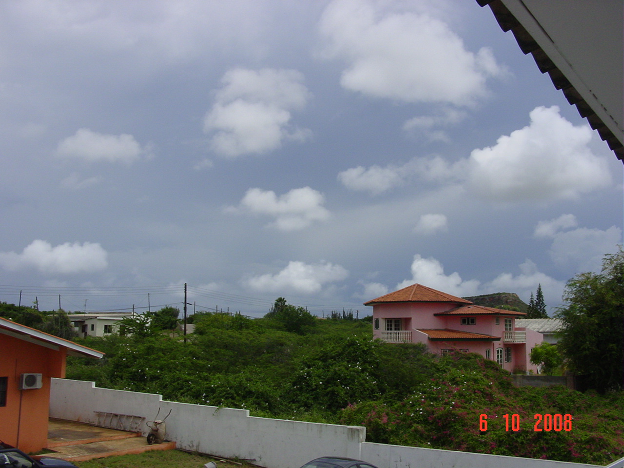
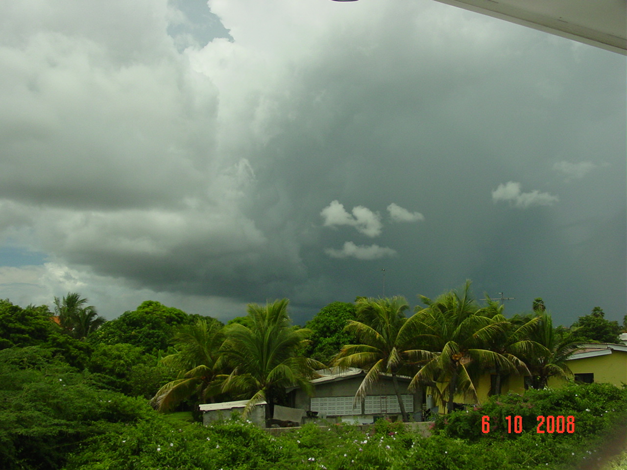
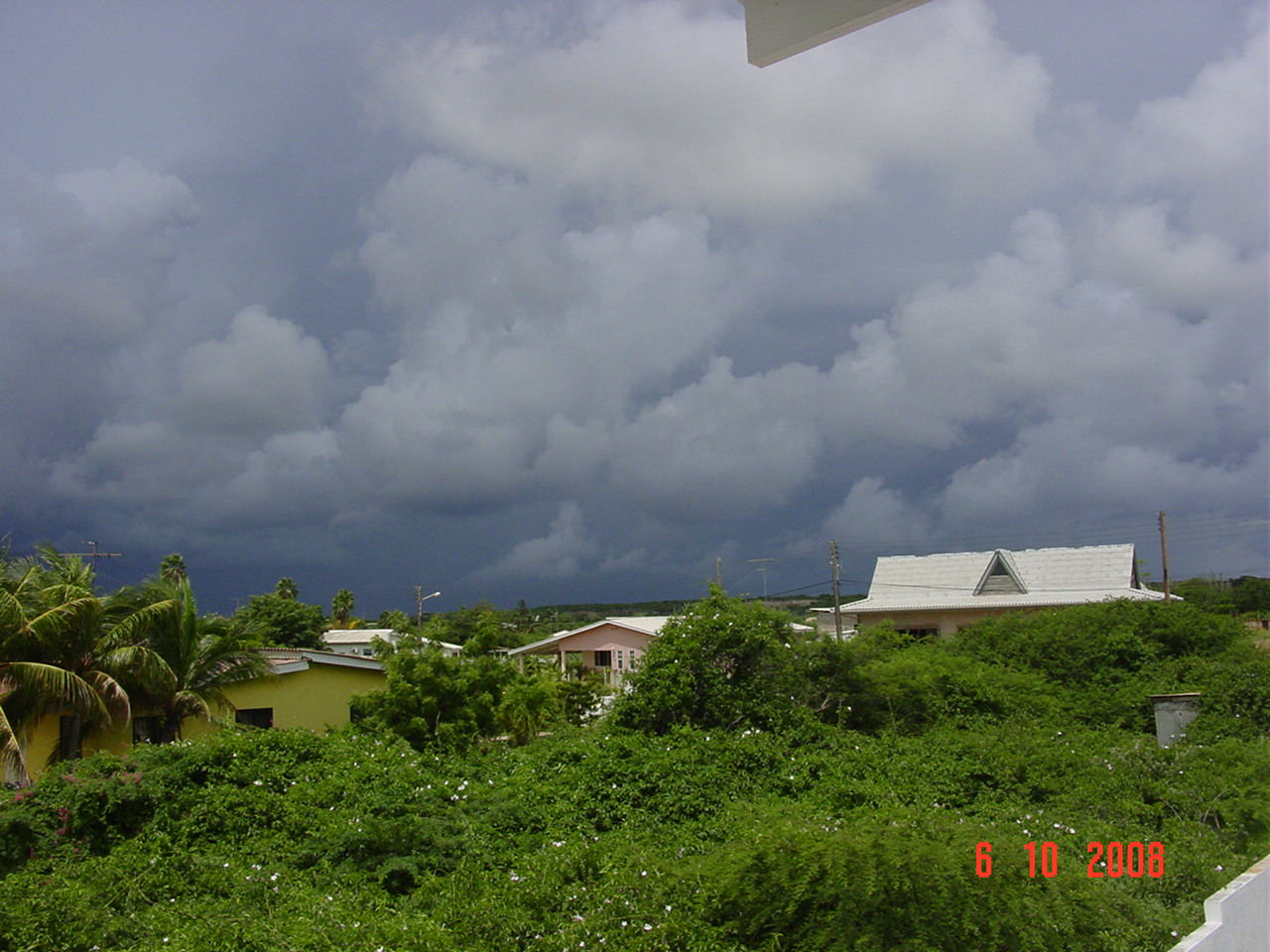
Hello,

This morning a huge white blob was heading towards Curacao on the radar. Other
than an early morning shower at 6am we have experienced zero rain and currently
we have blue skies in some areas and partially clouded blue skies in the
remainder of the sky above Curacao. The sea is flat and the waves and the wind
have turned and are coming in to shore from the southwest. The sea level has
risen 2 feet above normal.

It is a great day for diving at stingray city, the blue room and at mushroom
forest. For nondivers I recommend relaxing at the beaches of Curacao, hiking at
Malpais Wildlife Park, moutainbiking at JanThiel, and shopping in downtown at
Punda and Otrobanda.

The huge blob is still in the area whereas windguru predicted 20mm of rain...we
only had 0.3 mm so far since 6am.

Regards,

Wendy Martina
Curacao Wildlife
http://www.kunuku.net
|
|
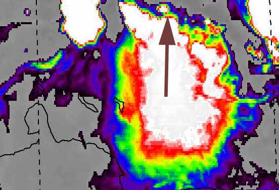
- How you identify a Cumulonimbus thunderstorm cloud?
|
- From: "Devin Balentina" <blue13x at hotmail.com>
- Date: Sun, 12 Oct 2008 16:47:12 -0400
|
Yes, October is finally here and it?s a good thing too, as I don?t think I
could have survived a few days longer with those 35+ degrees Celsius
temperatures. It?s literally raining everyday and as a result the local
temperatures have fallen dramatically.
Today I would like to talk about what I think is arguably a very important
subject when it comes to weather: the mighty Cumulonimbus clouds. Most important
weather events, whether it be Tornadoes, hail, Hurricanes, thunderstorms, strong
winds, etc. are most likely created or caused by this type of cloud. I?ve been
observing them for a long time and would like to talk about their external
experience to better help other identify them and as a result know when bad
weather is coming.
Cumulonimbus clouds, sometimes known as thunderheads or thunderclouds are
much larger and more vertically developed and dense clouds when compared to fair
weather cumulus clouds. . They sometimes form alone, in clusters, straight line
(also called squall line) or in a more severe form, called the Supercell..
?Fueled by vigorous convective updrafts (sometimes in excess 50 knots), the tops
of cumulonimbus clouds can easily reach 39,000 feet (12,000 meters) or
higher.?
Most people become aware of thunderstorms or types of bad weather when it?s
well over head. As a result it doesn?t come as a surprise that many people
identify thunderstorms with dark greyish clouds. This is how they appear, but
only when seen from beneath. Fact of the matter is that seen from afar,
Cumulonimbus thunder clouds have a pure (of)white color. Ironically, people
identify white clouds with sunny weather, it is for this small fact that
Cumulonimbus are to the untrained eye, quite hard to spot. The shape of these
clouds are characterized by their classic anvil shape: wide at the bottom, less
wide in the middle and again widening at the top.
Compare your average anvil: http://www.anvil-art.co.uk/media_pics/anvil5a.jpg with a classic Cumulonimbus thunder cloud: http://upload.wikimedia.org/wikipedia/commons/4/45/Big_Cumulonimbus.JPG
and the ultra dangerous and severe SuperCell: http://www.ems.psu.edu/~lno/Meteo437/SuperCell.JPG Notice the similar shape? Some people even speak of an ?exploding atom
bomb look,? this is especially true in the case of the super cell. Cumulonimbus
thunder clouds and Super cell are capable of some impressive heights, many times
reaching the limits of the Troposphere itself! This creates the flattened top
part, while in other cases this is also caused by high altitude winds. The high
winds are also to blame for the ?tail?. Notice the long tail in this picture:
http://www.missouriskies.org/archive/westtower.jpg
In some cases the cumulonimbus clouds can have such a vigorous updraft, that
it ignores the fact that there are high altitude winds or even the Troposphere
and continues to push upwards, creating a dome shape that is known as the
?overshooting top? that reaches well into the Stratosphere. A long-lasting
overshooting top is a sign of a very sever thunderstorm or Supercell, sometimes
capable of Tornadoes. Notice the overshooting dome shape above the flattened
top:
http://www.freewebs.com/tonyg1963/First%20Chase%20Files/overshoot_sml.jpg
Other than the shape, other tell-tale signs are the dense foamy structure,
pure of white color, which sometimes have a yellowish-tint, while at dusk or
dawn they have the regular orange tint. Don?t be fooled though, they sometimes
are hidden behind other clouds, but can be spotted because other clouds appear
to move faster. Last, but not least, sometime you can observe the mammatus
clouds beneath the flattened clouds, a sign of VERY bad weather: http://www.dphotojournal.com/wp-content/daily/mammatus-clouds.jpg and here: http://www.dnr.state.ne.us/floodplain/mitigation/mammatus3.jpg
When occurring in cumulonimbus, mammatus are often indicative of a
particularly strong storms or maybe even a tornadic storms
This simplified schematic drawing of a classic Superrcell can help you in
identifying one and knowing when bad weather is coming.: http://content.answers.com/main/content/wp/en-commons/thumb/9/9c/400px-Supercell02.jpg
I?ve included a picture below, which
|
|
|
- hopi awaseru
|
- From: informashon at tio-wan.com
- Date: 12 Oct 2008 17:36:27 -0000
|
Si Si..awor nos tin bos duru i hopi awaseru ku laman ketu ketu i niun bientu.


Yes, now we have thunder and lightning and many many many rain with very quiet
sea and no wind.

Ajo!

Tio Wan
|
|
- bos ta sona
|
- From: informashon at tio-wan.com
- Date: 9 Oct 2008 05:26:52 -0000
|
Awel si, bos ta sona masha duru mes i lantami fo'i sonjo.

A loud thunder woke me up from my dreams. I can hear thunder and see lightning
on the sea between Aruba Curacao and Venezuela. No wind, no rain, no clouds and
the sea is flat here at Watamula.
|
|
- A small tropical wave arrived from Venezuela and left...
|
- From: birdman at curacaowildlife.com
- Date: 8 Oct 2008 11:44:01 -0000
|
|
http://Stormcarib.com
20081008-7:00am (UTC: 11:00am)
Weather update for Curacao
Latitude: 12° 9'8.93"N
Longitude: 68°53'44.61"W
Report by: Marcus DeMaaijer (birdman -at- curacaowildlife.com)
A small tropical wave arrived from Venezuela at 3pm at Curacao and brought 24mm rain and a light thunderstorm. The lightning was concentrated in the area of Mahuma and Campo Alegre. Intra-cloud lightning was mostly observed over the sea due north of Playa Canoa. At 7am the last raindrop came down and clear skies are back again.
Godspeed to all of us in the Caribbean and on the surrounding mainland.
http://www.curacaowildlife.com/images/weather/20081008-7am.jpg
|
|
- bye bye rain...
|
- From: birdman at curacaowildlife.com
- Date: 6 Oct 2008 18:53:40 -0000
|
http://Stormcarib.com
20081006_14:47hrs local time (UTC: 18:47hrs)
Weather update for Curacao
Latitude: 12° 9'8.93"N
Longitude: 68°53'44.61"W
Report by: Marcus DeMaaijer (birdman -at- curacaowildlife.com)

Heavy rain and  light thunderstorms arrived in Curacao today starting at 7:30
am and continued on and off all the way till 1pm. The streets were flooded near
the SEHOS hospital, but only a light drizzle was experienced in the areas of
Choloma, Montagne Rey, Zuid Popo, Janwe and Dominguito where there were some
dark clouds passing overhead. Allot of rain was witnessed however offshore all
morning and until now between Curacao and Venezuela.

The sea is flat and weather numbers are as follows:

TEMP:  78.8 °F / 26.0 °C
HUMIDITY: 82%
PRESSURE: 29.80 in / 1009 hPa  (dropping)
VISIBILITY: 6.2 miles / 10.0 kilometers
WIND: ESE 4.6 mph / 7.4 km/h

Currently no rain and light clouds with spots of blue sky re-appearing... great
weather for shopping in Punda and snorkeling at Sea Aquarium.


Godspeed to all of us in the Caribbean and on the mainland.
|
|
- Update
|
- From: Reynald Dovale <reynald_dovale at yahoo.com>
- Date: Mon, 6 Oct 2008 09:44:59 -0700 (PDT)
|
A lot of thunder but no rain
We are experiencing a lot of thunder and clouds moving in a not normal direction. |
Attachment:
Picture 014.jpg
Description: JPEG image
Attachment:
Picture 015.jpg
Description: JPEG image
Attachment:
Picture 016.jpg
Description: JPEG image
Attachment:
Picture 017.jpg
Description: JPEG image
Attachment:
Picture 018.jpg
Description: JPEG image
|
|
- awaseru riba laman ketu
|
- From: informashon at tio-wan.com
- Date: 6 Oct 2008 11:44:46 -0000
|
Si, awor nos tin hopi awaseru riba laman ketu. Un tiki so a kai riba tera. Esei
kiermen ku e piskanan ta bini kantu i m'a gara dos purunchi: un p'ami i e otro
p'e gabilan.

Yes, now we have plenty rain on the sea. Only a little bit fall on land. That
means that the fish come to land and I catch two purunchi: one for me and one
for the osprey.

Ajo!

Tio Wan
|
|
- kandela den sielu
|
- From: informashon at tio-wan.com
- Date: 6 Oct 2008 00:20:33 -0000
|
Yes, it is night and we have kandela den sielu. That means we have fire in the
sky and rain. It is normal when the sun goes to sleep I go sleep too. Now I am
awake and listen to thunder and watch the fire in the sky.

Ajo!

Tio Wan
|
|
- awaseru riba dia di bestia
|
- From: informashon at tio-wan.com
- Date: 4 Oct 2008 16:00:43 -0000
|
Yes today we have hopi awasera riba dia di bestia. That means we have plenty
rain on the day of the animals. Now it rains in Banda Riba from Eastpoint to
Daniel. They have thunder too. Here in Watamula I am sitiing under the divi
divi tree to hide from the hot sun and to feel the nice cool wind (bientu) on
my face. Yes here in Watamula we have blue sky with plenty sun. The sea is flat
but one meter higher than normal. This is good for the baby sea turtles to find
their way to sea. This morning I saw at Shete Boca 3 nests hatch at 5:30 am and
the last baby turtle went swimming into the sea at 7:45 am.

Tio Marcus tells me that today on the day of the animals (dia di bestianan di
mondi)Curacao Wildlife has an open house at kaya kiwa 29 (bario di schelpwijk)
from 11am to 5pm and that peoples can donate food for the wild animals and
become member of the junior wildlife rangers from 9 years and older.

Ajo!

Tio Wan
|
|
- GAbilan di Laman
|
- From: informashon at tio-wan.com
- Date: 1 Oct 2008 12:00:46 -0000
|
Yesterday I find GAbilan di Laman along the water at Westpoint. His left wing
is not so good now. This morning I wake up to catch fish. The sky was very red
in the east. This means that there is rain in the air. Now the sky is
everywhere shinishi. This means the sky has many clouds everywhere so you do
not see the blue. I caught two fish and that is enough: one for me and one for
the GAbilan di Laman. The dutchmans call it visarend and Tio Boy says it has
name of osprey.

Ajo!

Tio Wan.
|
|
- the light from HEaven
|
- From: informashon at tio-wan.com
- Date: 30 Sep 2008 11:43:07 -0000
|
The seven songs of the chuchubi bird woke me up this morning at 6:24 am. The
light from HEaven will shine 12 hours and 42 minutes today in Curacao. Tomorrow
there will be 41 seconds less sunlight. It is so nice and clear today that I
can see the island Aruba from The Kura Hulanda Lodge at Watamula. The sea waves
are small and there are no clouds in the air. This will be a nice day to go
picking Kenepa fruit and Shimaruku fruit from the trees in the mondi of Kristof.

Ajo!

Tio Wan
|
|
- in Curacao it is very quiet
|
- From: informashon at tio-wan.com
- Date: 24 Sep 2008 04:05:06 -0000
|
Yes I am watching the lightning in Aruba. But in Curacao it is very quiet. We
have no wind and no rain and it is a cool 27 celsius.

Ajoo!

Tio Wan.
|
|
- invest 93L moving south instead of north
|
- From: help at curacaowildlife.com
- Date: 23 Sep 2008 19:18:50 -0000
|
Can someone please contact the NWS TPC/NATIONAL HURRICANE CENTER MIAMI FL,
because invest 93L is not moving North and NW...it is actually moving South and
SE towards Aruba. They are reading their chart upside down!!!

Hey Dave and Gert...it's tuesday..., cuz I am seeing a sunday report on the
homepage as the latest news...


The weather experience currently here in Curacao is a cool breeze, 33 degrees
celsius, blue skies, and smally choppy waves from the southwest. The sea level
pressure is at 1008 hPa. The wind is picking up as the outer tentacle of invest
93L is approaching...but I don't think we'll get any of the weather that Aruba
is experiencing...

I have a pastechi riding on this as a bet, so we'll see.
|
|
- Fw: nice weather in Korsou
|
- From: informashon at tio-wan.com
- Date: 23 Sep 2008 18:28:59 -0000
|
> Yes, we have good weather today. One degree celsius less hot than yesterday!
> Today we have 34 degrees and blue sky. The sea is flat flat! We can see at
> Watamula that Aruba weather is not so nice.
>
> ajoo!
>
> Tio Wan
>
>
|
|
- Dushi i kajente weather
|
- From: info at kunuku.net
- Date: 22 Sep 2008 20:06:13 -0000
|
Greetings and salutations to everyone in the Caribbean.

Here is Curacao we have flat sea, almost no wind, no rain, blue sky, and
temperature near 35 degrees celsius in the shade.

Ajoo!

Tio Wan.
|
|
- resend pictures
|
- From: Robert Candelaria <robertcandelaria at rocketmail.com>
- Date: Sat, 20 Sep 2008 12:03:04 -0700 (PDT)
|
still sunny on the island and no much clouds
waiting to see if the weather will change to a rainy one
i hereby resend the pictures of the rainy day of yesterday
sorry for the inconvenience
robby
|
Attachment:
DSC_2920.JPG
Description: JPEG image
Attachment:
DSC_2923.JPG
Description: JPEG image
Attachment:
DSC_2932.JPG
Description: JPEG image
Attachment:
DSC_2935.JPG
Description: JPEG image
|
|
- some rain
|
- From: Robert Candelaria <robertcandelaria at rocketmail.com>
- Date: Sat, 20 Sep 2008 10:07:12 -0700 (PDT)
|
yesterday we had some rain after waiting very long for it
we needed it very much because the island is dry
this morning the island is a little overcast, seems like we under influence of the tropical wave thats coming from the leeward islands
hope we get some rain, but not like the islands got with floodings etc.
will keep you inform
nice week-end
robby
see some pictures of yesterday
|
|
|
- remember Lenny?
|
- From: help at curacaowildlife.com
- Date: 18 Sep 2008 13:24:50 -0000
|
That blob to the left of the ABC islands is starting to spin in a clockwise
direction, just like Lenny did in 1999...

(goosebumps)
|
|
- sail aho!!
|
- From: bonbini at dushicuracao.net
- Date: 14 Sep 2008 19:02:15 -0000
|
Blue skies, 28 degrees celsius, and great sailing wind from NE. This is a
welcome change from the hot weather we experienced when Ike was beating his
chest and huffing and puffing in the Caribbean.

I'm sailing back from Klein Curacao to (big) Curacao, and saw schools of
dolphins and one humpback whale.
|
|
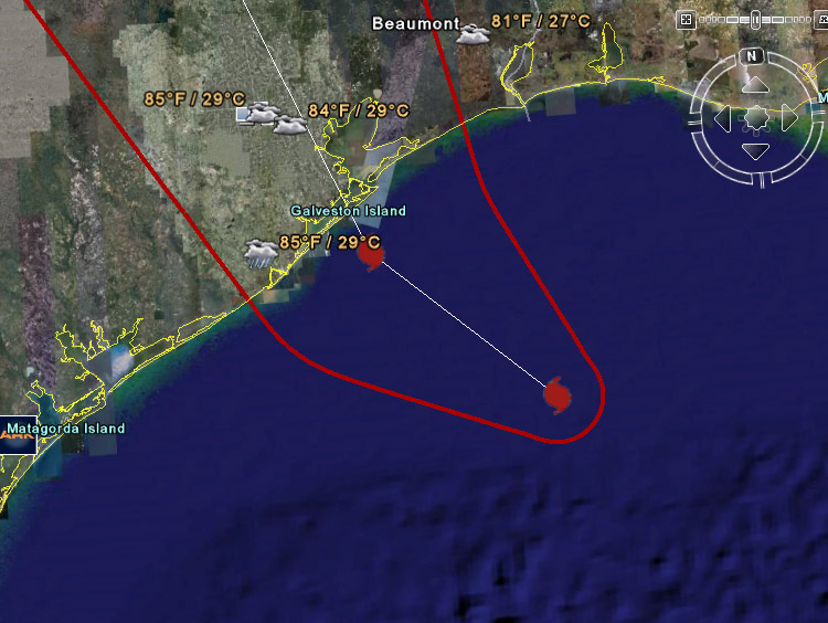
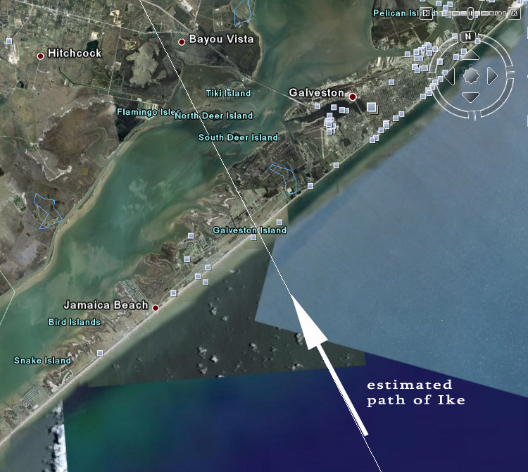
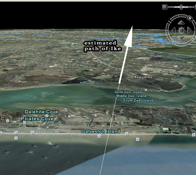
- video shows why people did not leave Galveston
|
- From: birdman at curacaowildlife.com
- Date: 14 Sep 2008 03:04:57 -0000
|
|
http://Stormcarib.com
20080913_23:10hrs (UTC -4)
Curacao
Latitude: 12° 9'8.93"N
Longitude: 68°53'44.61"W
Report by: Marcus DeMaaijer (birdman -at- curacaowildlife.com)
Reason why most people did not leave the island of Galveston (Texas) in the path of Ike is because Steve LeBlanc, who is the Galveston City Manager, said that max winds would be up to 74 mph and total storm surge of 4 to 8 feet in this video
http://abclocal.go.com/ktrk/media?id=6382486
|
|
- changing the name for storm surge to...
|
- From: birdman at curacaowildlife.com
- Date: 13 Sep 2008 03:28:52 -0000
|
|
http://Stormcarib.com
20080912_23:30hrs (UTC -4)
Curacao
Latitude: 12° 9'8.93"N
Longitude: 68°53'44.61"W
Report by: Marcus DeMaaijer (birdman -at- curacaowildlife.com)
Maybe we ought to change the terminology for rising water in front of a storm from "Storm Surge" to "Storm Flood". Ranging from severity we ought to give additional descriptive names to the different types of storm surges ranging from "House Wrecker Flood" to "Widow Maker Flood".
Maybe in this manner people will take a storm surge serious...
Dontcha agree that "storm surge" is a wimpy description that won't motivate people to pack things and head for the hills?
Godspeed to all in the Caribbean and to all on the surrounding mainland.
|
|
|
- no time for stupidity...get out !!!
|
- From: birdman at curacaowildlife.com
- Date: 13 Sep 2008 00:47:06 -0000
|
|
|
|
- 3.5 waves in the Atlantic heading westwards
|
- From: birdman at curacaowildlife.com
- Date: 11 Sep 2008 11:58:05 -0000
|
http://Stormcarib.com
20080911_08:00hrs (UTC -4)
Weather update for Curacao
Latitude: 12° 9'8.93"N
Longitude: 68°53'44.61"W
Report by: Marcus DeMaaijer (birdman -at- curacaowildlife.com)
Three tropical waves are racing westwards from the Atlantic to the Caribbean, and more more is about to glide off the African continent's western coast. This past week we passed the peak of the hurricane season. With one more half to go...let's keep a diligent watch on any wave, even the unorganized ones. In our experience in the ABC islands it can be clear one minute and within a half hour something pops* up in the air, because we were careless about a passing wave.
*(in reference to the funnel clouds last month that caused light damage to 40 buildings)
Godspeed to all of us in the Caribbean and on the surrounding mainland.
| |
|
|
- perfect seaturtle egg incubation weather...
|
- From: birdman at curacaowildlife.com
- Date: 6 Sep 2008 01:57:39 -0000
|
http://Stormcarib.com
20080905_21:50hrs (UTC -4)
Weather update for Curacao
Latitude: 12° 9'8.93"N
Longitude: 68°53'44.61"W
Report by: Marcus DeMaaijer (birdman -at- curacaowildlife.com)
The tropical wave that was posted earlier today is currently located at 53W S of 15N and is moving between 18 and 27 Km/h in a westerly direction. At this moment it is unlikely to become more organized and develop into a depression.
Todays weather in Curacao dry, overcast skies, and was moderately humid and temperatures soaring to 93 F or 34 C aka perfect seaturtle egg incubation weather...
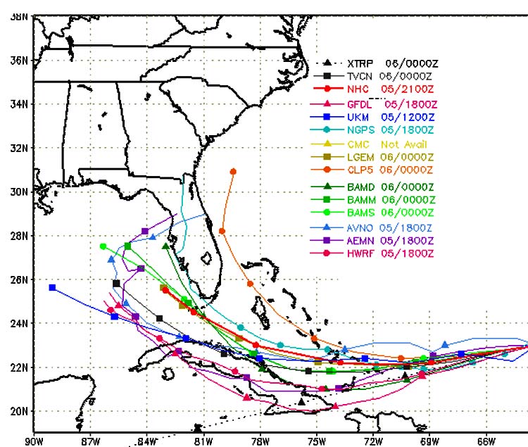
As for Ike... if you want to believe the NHC, BAMM, and the BAMD computer models in the image below... this storm will stay on the body of water called the Florida Straights right between Florida and Cuba's northern coastline and race over the Florida Keys towards New Orleans as a Cat.2...
Ike looks like it is gonna leave a mean impact b
ehind in the history books just like his (censored) namesake who slapped Tina around...
ps: if you ever wondered what the letters at top of this computer model map (see below) mean...here ya go:
XTRP - Extrapolation using past 12-hr motion (NHC)
TVCN - Consensus of GFS, UKMET, NOGAPS, GFDL, HWRF, GFDN, and ECMWF models (replaces old CONU model)
NHC - National Hurricane Center official forecast
BAMD - Beta and Advection model, deep (NHC)
BAMM - Beta and Advection model, medium (NHC)
BAMS - Beta and Advection model, shallow (NHC)
GFDL - Geophysical Fluid Dynamics Laboratory (GFDL) model
UKM - United Kingdom Meteorological Office (UKMET) model (Developmental)
NGPS - United States Navy Global Atmospheric Prediction System (NOGAPS) model
AVNO - NOAA Global Forecast System (GFS) model (formerly known as the AVN/MRF)
AEMN - NOAA GFS Ensemble Mean
HWRF - NOAA Hurricane
Weather and Research Forecast (HWRF) model
CMC - Canadian Meteorological Centre (CMC) model
LGEM - NOAA Logistic Growth Equation Model (LGEM)
CLP5 - CLImatology-PERsistance (CLIPER) model 5-day (NHC)
Godspeed to all of us in the Caribbean and on the surrounding mainland.
| |
|
|
- hmm well look what's sneaking up on us...
|
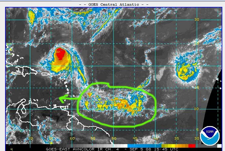
- From: birdman at curacaowildlife.com
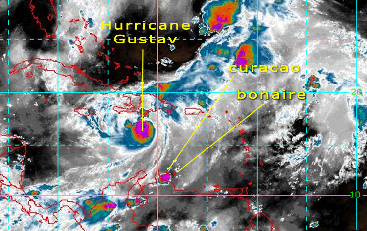
- Date: 5 Sep 2008 16:57:04 -0000
|
http://Stormcarib.com
20080905_12:50hrs (UTC -4)
Weather update for Curacao
Latitude: 12° 9'8.93"N
Longitude: 68°53'44.61"W
Report by: Marcus DeMaaijer (birdman -at- curacaowildlife.com)
A rather large tropical wave is heading towards the ABC islands which is located due south and in between of Ike and Josephine (see satellite image below)... As soon as more data about this wave becomes available it will be posted.
Godspeed to all of us in the Caribbean and on the mainland.
|
|
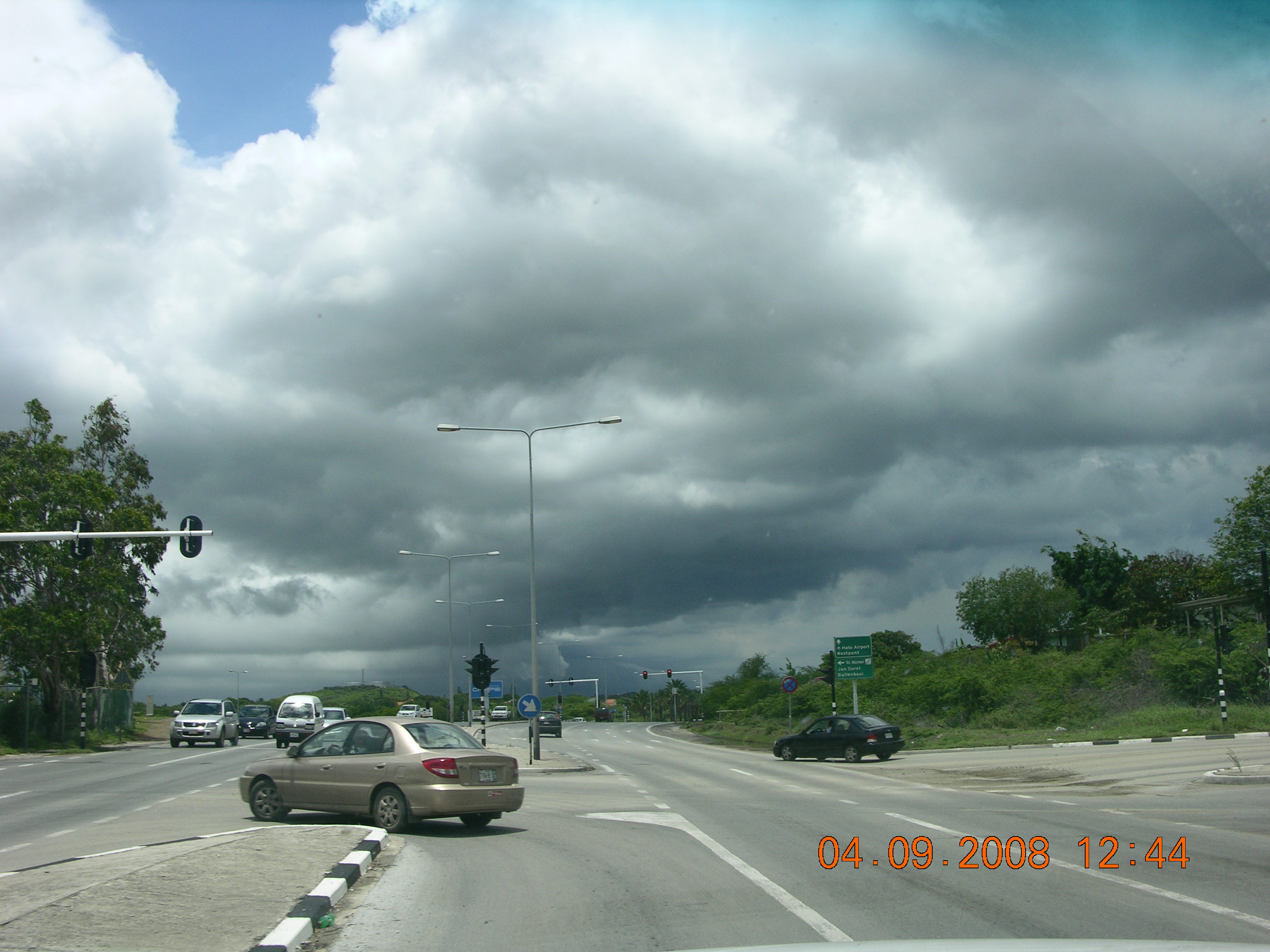
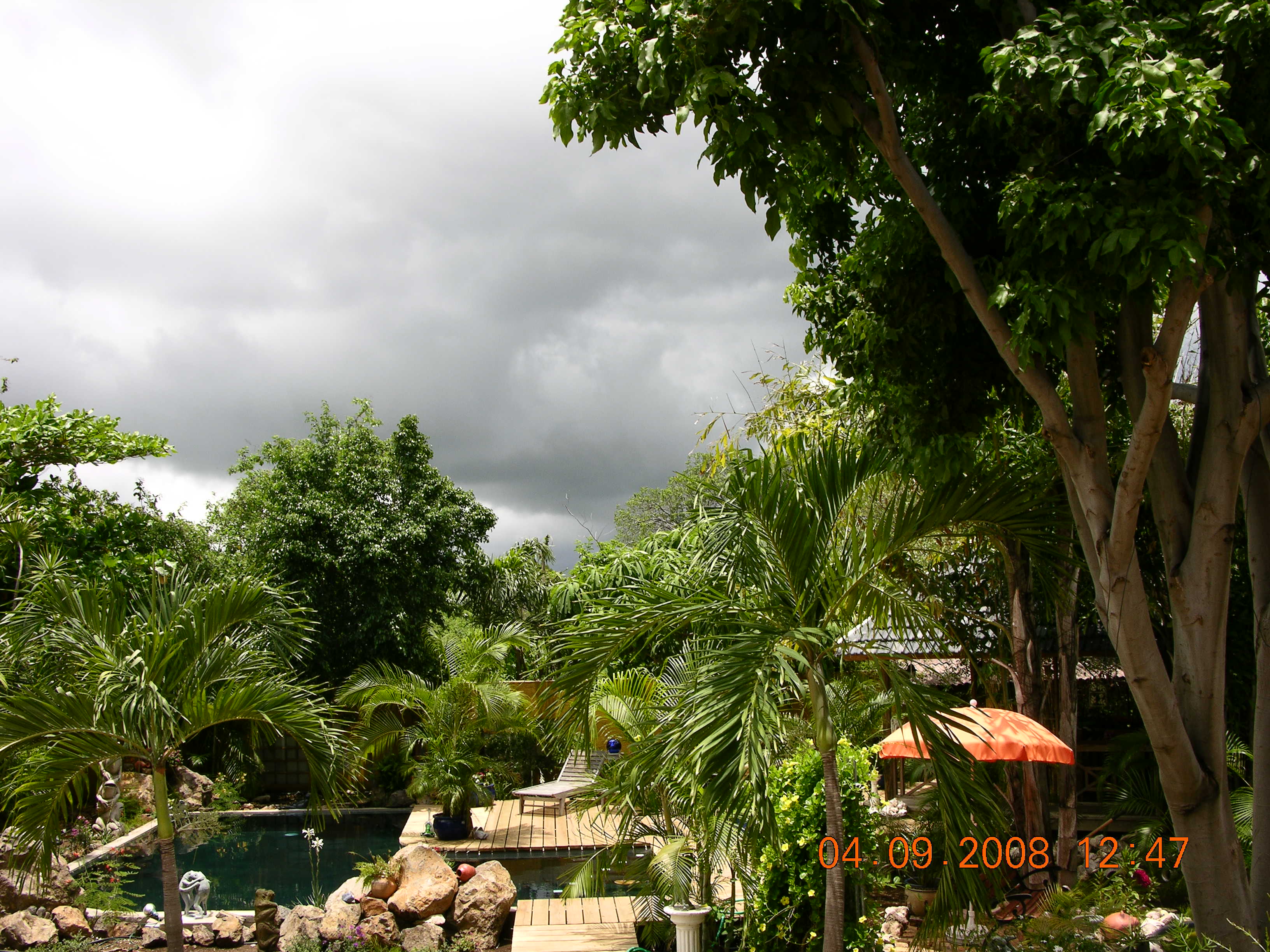
- Update
|
- From: "Moedt Bouwbedrijf NV" <bea at moedt.com>
- Date: Thu, 4 Sep 2008 14:30:49 -0400
|
|
Attachment:
DSCN8174.JPG
Description: JPEG image
Attachment:
DSCN8171.JPG
Description: JPEG image
Attachment:
DSCN8172.JPG
Description: JPEG image
Attachment:
DSCN8173.JPG
Description: JPEG image
|
|
- 260 mm of rain so far at Playa Canoa on Curacao
|
- From: birdman at curacaowildlife.com
- Date: 4 Sep 2008 11:31:25 -0000
|
http://Stormcarib.com
20080904_07:32hrs local time (UTC -4)
Weather update for Curacao
Latitude: 12° 9'8.93"N
Longitude: 68°53'44.61"W
Report by: Marcus DeMaaijer (birdman -at- curacaowildlife.com)
Heavy rain and thunderstorms arrived in Curacao today at approx 1 am on Sept. 4th, 2008. In our location at Playa Canoa we have registered 26 cm of rain between 1 am and 7 am and it doesn't look like the rain will cease anytime soon... The rain was generated by an outer tentacle of Tropical Storm Hanna which came from the southwest and moved NNE very slowly at approx 6 mph (9.6 Km/hr). The thunderstorms were visible offshore at approx 9:00 pm on the day before. The precipitation is expected to continue all day varying from light to heavy with temperatures soaring to 91° F. / 33° C with overcast skies. See also current satellite image below...
Cat. 4 Hurricane Ike has a well defined eye and way out of reach of the ABC islands (th
ank God) just like Hanna is moving NW whereas Hanna is moving slowly, Ike on the other hand seems to be in a rush and is speeding towards NNW and is later today to dip a bit to the south and then move NW for the remained of the day. But...do not bank on this because these storms this season have continuously been doing othr things than the computer models have predicted within a prediction window of 12 to 18 hours. Josephine is also currently not en route to Curacao and appears to vear off due north of us, but don't throw caution in the wind and write it off just yet. Please keep Emily and Ivan in the back of your head, and be on the alert...
Godspeed to all of us in the Caribbean and on the mainland.
| |
|
|
- rain thunder and lightning
|
- From: Robert Candelaria <robertcandelaria at rocketmail.com>
- Date: Thu, 4 Sep 2008 03:49:58 -0700 (PDT)
|
we were asking for rain and here it is
sins last night we are very overcast
grey clouds are covering the island and we are having rain thunder and lightning
seems like it will hold on for a while
will update later today
take care
robby |
|
|
- incredible
|
- From: Robert Candelaria <robertcandelaria at rocketmail.com>
- Date: Tue, 2 Sep 2008 09:09:00 -0700 (PDT)
|
incredible all those storms behind each other
it looks like a chain
hope that in New Olean they will get things together soon
by us it's still hot but instead of a bleu sky yesterday and the day before, today we have some clouds
mayby we could get some rain
this because of the influence of now tropical storm Hanna
being in the beginning of september we still have three month to go
hold tight and be safe
robby
|
|
|
- hot hot hot
|
- From: Robert Candelaria <robertcandelaria at rocketmail.com>
- Date: Sat, 30 Aug 2008 09:53:09 -0700 (PDT)
|
It's really hot on the island
looks like hurricane Gustav and tropical storm Hanna took all our breeze away
it's time to get some rain to cool down the island
once in a while there is a light breeze coming for different direction
let's hope the rain wont stay out long
let's hope that the islands who got hit will pick-up soon and God spare the rest
have a nice weekend
robert |
|
|
- Today we broke the heat record of 33 degrees celsius in 1997!!!
|
- From: sunny_skies at curacaowildlife.com
- Date: 28 Aug 2008 00:22:50 -0000
|
http://Stormcarib.com
20080827_20:23hrs (UTC -4)
Weather update for Curacao
Latitude: 12° 9'8.93"N
Longitude: 68°53'44.61"W
Report by: Ronald (sunny_skies -at- curacaowildlife.com)

Early this morning Curacao got dumped on by a massive raincloud from an outer
band of Gustav and during the day everyone on the island got cooked like a pan
dushi bread in the oven. With no wind in the air the sahara dust had no place
to go but litterally hang around and as a result the sunheated dust particles
acted like coal in a closed bbq: the heat was increased tenfold. Today we broke
the heat record of 33 degrees celsius that was set in 1997!!! My intruments
recorded temperatures soaring to 34 degrees celsius inland and 31 degrees near
the shore.  Standing in line at the trafic lights almost caused drivers to
faint. Breathing hot air through your mouth was unbearable. It felt like being
in the desert during a sandstorm. Aug, Sept. and October are seasonally the
hottest months of the year but we never before felt this kind of heat since the
record temp of 33 in 1997. The sun has set and the temp is 29 degrees, and it
is dropping slowly...THANK GOD!

Currently I am at Shete Boca (by myself) and I can see lightning offshore in
the NW. This thunderstorm appears to be moving forward towards Curacao. The
GOES satellite images however do not show anything NW of Curacao... I hope the
rain does come this way to drive away the heat.

Ps: kudos to onenet & UTS for wireless internet via laptop.


(ps: this is for Annie in Bonaire: ticks travel on iguanas too.)
|
|
- 18 cm rain so far
|
- From: help at curacaowildlife.com
- Date: 27 Aug 2008 04:22:05 -0000
|
http://Stormcarib.com
20080827_00:22hrs (UTC -4)
Weather update for Curacao
Latitude: 12° 9'8.93"N
Longitude: 68°53'44.61"W
Report by: Birdman (help -at- curacaowildlife.com)
Heavy rain and thunderstorms continue in Curacao. In our location at Fuikbaai we have registered 18 cm of rain so far...and it doesn't look like the rain will stop anytime soon...
|
|
- rain and thunder
|
- From: help at curacaowildlife.com
- Date: 27 Aug 2008 02:05:03 -0000
|
|
http://Stormcarib.com
20080826_22:04hrs (UTC -4)
Weather update for Curacao
Latitude: 12° 9'8.93"N
Longitude: 68°53'44.61"W
Report by: Birdman (help -at- curacaowildlife.com)
Hurricane Gustav which is heading away from the ABC islands towards Haiti which is still recovering from the damage done by Fay only 10 days ago.
Today in the am we had some light showers in Curacao, and then the rest of the day a wee bit hot, but sunny skies all day. Because the humidity was near 60 percent all afternoon it did not feel as hot as yesterday.
Currently we are at the southern coastline and about a half hour or so ago we witnessed a horizon wide sized wave of thunderstorms as far as the eye can see racing towards us. The speed at which it took to g
et here really took us by surprise. It is not raining in our location but we can see that the inland is being soaked again for the second night in a row... yay...(no seriously, we do need some rain...)
|
|
- light rain and thunderstorms heading NE into open sea
|
- From: help at curacaowildlife.com
- Date: 26 Aug 2008 08:03:32 -0000
|
|
http://Stormcarib.com
20080826_04:03hrs (UTC -4)
Weather update for Curacao
Latitude: 12° 9'8.93"N
Longitude: 68°53'44.61"W
Report by: Giselle B. (help -at- curacaowildlife.com)
Invest 94 has now become Cat. 1 Hurricane Gustav which is heading away from the ABC islands towards Cuba.
The outer band of Hurricane Gustav continues to affect the weather in Curacao. Wind is turning, coming from south and heading towards North.
Precipitation has decreased to light rain, thunderstorms have moved offshore and are heading towards Bonaire. Wind speed has dropped to: 7 mph / 11.2 km/h.
Furthermore sea level pressure has increased to 29.83 in / 1010 hPa.
We just registered the 72nd turtle
nest during pouring rain...Birdman didn't bring a rainjacket and he's soaked :-)
ps: tnx to our sponsor Scarlet for wireless internet.
|
|
- heavy rain and crazy wind from SW
|
- From: help at curacaowildlife.com
- Date: 26 Aug 2008 07:17:02 -0000
|
http://Stormcarib.com
20080826_03:17hrs (UTC -4)
Weather update for Curacao
Latitude: 12° 9'8.93"N
Longitude: 68°53'44.61"W
Report by: Birdman (help -at- curacaowildlife.com)
Invest 94 has now become Cat. 1 Hurricane Gustav which is heading away from the ABC islands towards Cuba.
Curacao is currently being affected by an outer band of Hurricane Gustav which includes thunderstorms and wind coming from southwest heading towards NE.
Heavy rain is now falling from the skies with wind speed: 10 mph / 16 km/h.
Furthermore sea level pressure is 29.80 in / 1009 hPa.
|
|
- fire in the sky
|
- From: bonbini at dushicuracao.net
- Date: 26 Aug 2008 07:02:43 -0000
|
http://Stormcarib.com
20080826_03:00hrs (UTC -4)
Weather update for Curacao
Latitude: 12° 9'8.93"N
Longitude: 68°53'44.61"W
Report by: Birdman (help -at- curacaowildlife.com)
Invest 94 has now become Cat. 1 Hurricane Gustav.
FORECAST POSITIONS AND MAX WINDS
INITIAL 26/0300Z 16.6N 71.4W 60 KT 69 MPH TS
12HR VT 26/1200Z 17.5N 72.6W 65 KT 75 MPH CAT-1
24HR VT 27/0000Z 18.5N 73.9W 80 KT 92 MPH CAT-1...INLAND
36HR VT 27/1200Z 19.3N 75.1W 75 KT 8
6 MPH CAT-1
48HR VT 28/0000Z 19.8N 76.2W 80 KT 92 MPH CAT-1
72HR VT 29/0000Z 20.5N 78.0W 75 KT 86 MPH CAT-1
96HR VT 30/0000Z 21.5N 80.5W 75 KT 86 MPH CAT-1
120HR VT 31/0000Z 23.0N 83.5W 75 KT 86 MPH CAT-1
Curacao is currently being affected by an outer band of Hurricane Gustav which includes thunderstorms and wind coming from southwest heading towards NE.
Precipitation is currently zero and wind speed: 8 mph / 12.8 km/h.
Furthermore sea level pressure is 29.80 in / 1009 hPa.
|
|
- blue skies are back
|
- From: help at curacaowildlife.com
- Date: 25 Aug 2008 21:05:20 -0000
|
|
http://Stormcarib.com
20080825_17:00hrs (GMT -4)
Weather update for Curacao
Latitude: 12° 9'8.93"N
Longitude: 68°53'44.61"W
Report by: Birdman (help -at- curacaowildlife.com)
Invest 94 brought heavy rain to Curacao yesterday. At seroeloraweg 6cm of rain was registered. Today only blue skies
and zero wind. A perfect day for flying and tanning at the beaches...
|
|
- strange weather
|
- From: bonbini at dushicuracao.net
- Date: 24 Aug 2008 18:47:59 -0000
|
Currently the weather is weird at Curacao":
along the southern coast flat sea, blue skies and partial cloudy in some parts
whereas Bandabou, St.Joris, and Souax the rain is so heavy that the iguanas are
falling out of the trees. The waves are huge at the northern surfer's paradise
cove Playa Canoa whereas teh sea is flat along the southern coastline... weird.

and this is just the start....according to the sat images there is more to come.
|
|
- blue skies are back...but not for long
|
- From: bonbini at dushicuracao.net
- Date: 24 Aug 2008 15:39:32 -0000
|
|
http://Stormcarib.com
20080824_11:33hrs (GMT -4)
Weather update for Curacao
Latitude: 12° 9'8.93"N
Longitude: 68°53'44.61"W
Report by: Marcus DeMaaijer (bonbini -at- dushicuracao.net)
The thunderstorm ahead of Invest 94 brought heavy rain to Curacao between 1am and 8:30 am. Currently we have blue skies in some parts and partial overcast skies in other parts as we are right in between of the two waves. The center of the next wave - which is called invest 94 - is expected to pass due north of Curacao between 4 and 8 pm local time UTC -4. The first part of the front can be experienced between noon and 1 pm today. Since August and September are the seasonal times of the year for warwaru's (tiny funnel clouds) we should keep our eyes to the sky for the
next 30 days, because these warwaru's are so tiny, there is no advance warning possible other than personal observation and subsequent visual monitoring of a dark cloud overhead...
Warwaru's that occur in Curacao are known not to be as severe as the ones you find on the American mainland. Tornadoes - as they are called in the USA - are measured rom category 1 thru 5. The warwaru's in Curacao are in the same strngth measurement about 0.2 tot 0.6, so very weak in comparison to their American counterparts.
Furthermore, the warwaru's in Curacao are very rare natural events that do not last more than ten minutes after touching ground. Damage to surroundings can vary from toppled trees and unsolid built roofs ripped off houses and garages and cars moved into the neighbor's yard. The warwaru's are fortunately most times not strong enough to suck a vehicle into the air (thank god). Humans on the other hand should take cover and walk into the opposite direction...yes
this is a no brainer but during yesterday's warwaru, people ran towards it to see what was going on... It was a miracle that no fool got hurt by swirling debris...
you can view new pictures of yesterday's warwaru at http://www.24ora.com/content/view/5908/6/ (Kudos 2 Bonaire's StormCarib correspondent Ann Phelan for this link)

|
|
- rain rain rain....
|
- From: bonbini at dushicuracao.net
- Date: 24 Aug 2008 05:41:26 -0000
|
|
http://Stormcarib.com
20080824_01:33hrs (GMT -4)
Weather update for Curacao
Latitude: 12° 9'8.93"N
Longitude: 68°53'44.61"W
Report by: Marcus DeMaaijer (bonbini -at- dushicuracao.net)
At about 1 am a loud thunder sound knocked me out of bed. Upon
consulting the sat images at stormcarib I saw this wave of bad
weather below racing towards us, whereas at 6 pm yesterday it
appeared to miss us completely due north.
This update shows a diferent scenario.
Around 10 am on saturday August 23 (yesterday) two mini
tornadoes caused havoc in the Buena Vista neighborhood
ripping roofs open and sucking furniture into the air.
Fortunately, no human loss of life. Sadly an entire iguana
family became treeless after their wabi tree was knocked down.

|
|
- Fay...
|
- From: bonbini at dushicuracao.net
- Date: 17 Aug 2008 20:48:27 -0000
|
The eye of cat. 1 hurricane Fay will pass just by my uncle's house on Tuesday
at 2 pm... He will email me some pictures and I'll place them here.
|
|
- all clear...
|
- From: Marcus DeMaaijer <demaaijer at yahoo.com>
- Date: Tue, 12 Aug 2008 11:14:53 -0700 (PDT)
|
The rain and thunder has passed. The wind is about 3 to 5 mph. The sea is flat with a hazy sky in some parts while other parts the sky is a very purty blue... |
|
|
- bad weather heading from west to east
|
- From: Marcus DeMaaijer <demaaijer at yahoo.com>
- Date: Tue, 12 Aug 2008 09:51:09 -0700 (PDT)
|
Even though the sat image does not show much happening in our area... in reality Curacao is currently experiencing heavy rain and sporadic thunder. Just like Lenny, this bad weather is heading from west to east....weird....
by the way, I recorded the Perseids Meteor shower in clear skies between 3:30 am and 5:40 am this moring on video, and with a Nikon D300 I recorded over 100 pictures of meteor streaks at Raw, large, fine format. Anyone interested in obtaining the video and pictures on a DVD? |
|
|
- needlecloud that did not touch the water NE of Canoa
|
- From: bonbini at dushicuracao.net
- Date: 6 Aug 2008 14:30:46 -0000
|
This morning around 7 am a rather small rain system rolled over Curacao coming
in from the SouthEast from Venezuela. Some heave to moderate rain fell in some
spots in Curacao. There was even a funnel cloud spotted at sea NE of Playa
Canoa that did not touch the water. If it did it could have become a
waterspout. Around 8am some light rain touched ground here and there, and a
half hour later the skies cleared up. Another small wave with lotsa moisture is
heading towards Curacao, but it is still about 3 to 5 hours away, so anything
can happen: it can still dissipate or vear off to the north.

Most funnel clouds near Curacao are observed far offshore and rarely hit land.
A funnel cloud is a funnel-shaped cloud of condensed water droplets, associated
with a rotating column of air and extending from the base of a cloud (usually a
cumulonimbus or towering cumulus cloud) but not reaching the ground or a water
surface. A funnel cloud is usually visible as a cone-shaped or needle like
protuberance from the main cloud base. Funnel clouds frequently form in
association with supercell thunderstorms.

If a funnel cloud touches the ground it becomes a tornado. Most tornadoes begin
as funnel clouds, but many funnel clouds do not make ground contact and so do
not become tornadoes. Also, a tornado does not necessarily need to have an
associated condensation funnel?if strong cyclonic winds are occurring at the
surface, then the feature is a tornado. Some tornadoes may appear only as a
debris swirl, with no obvious funnel cloud extending below the rotating cloud
base.

A funnel cloud that touches down on, or moves over water is a waterspout.

Most funnel clouds near Curacao are waterspouts and are fairly unstable and
will dissipate within minutes after forming.
|
|
- up up and away...
|
- From: bonbini at dushicuracao.net
- Date: 4 Aug 2008 16:01:02 -0000
|
Invest 99 is forecasted to head up, up, and then away from the Caribbean and
become a nuisance for the Atlantic maritime traffic.

http://www.wunderground.com/tropical/at200899.track.html

This is a good start of the month August this hurricane season...

Curacao was drenched a bit around 10 am yesterday, and from then on only sunny
skies. The wind is a bit strong and gusty but that is great for kitesurfing at
St Joris and windsurfing at Mambo and Cat Sailing at Jan Thiel, and flying
kites at SDK's parkinglot.

This afternoon I'll be flying kites myself at Playa Canoa after 6pm...cya there?
|
|
- meteors and egglaying turtles! coincedence?
|
- From: bonbini at dushicuracao.net
- Date: 2 Aug 2008 05:21:43 -0000
|
Yes Siree,

Just came back from watching a rare green turtle lay eggs in the sand at a
northern beach cove in Curacao. A few nights ago another green turtle lay her
eggs at Klein Curacao, a mile long island approx 10 miles due southeast of
Curacao.

Nothing noteworthy to report about the weather since July 23rd other than
everyday blue skies and after each b-e-a-u-t-i-ful sunset only clear starry
skies. I hope this weather keeps up for the August 12 meteor shower watch so
that you can expect to count between 20 and 30 meteors per hour during the
Perseids Meteor Shower.

This meteor event is taking place round the clock at every minute of each 24
hours day. This year, the shower will be active between about July 30 and
August 25. Of course, fewer meteors will be visible further away from the
August 12 peak.

Just like striking a match goes unnoticed outdoors at noon, you can lay on your
back all day and watch the skies to detect a space rock bouncing off molecules
in our atmosphere, but you can't see it against a sunlit sky. Your best chances
are at night in an area which is not illumuninated by any type of lightsource.
Your best bet will be an open field away from the lights of streets, PDVSA,
homes and office buildings. In Curacao this is at Playa Canoa, Watamula,
St.Joris, Fuik, San Juan, Ascenshon, Kristof, Shete Boca, Daaibooi baai,
Caracasbaai, Zoutpan di Willibrordes, St. Michielbaai, tereno di Maal, to name
a few.

You don't need a campfire, flashlights, or binoculars. All you need is a beach
chair, air mattress, or anything else that allows you to be in a relatively
horizontal position (standing up is vertical). And oh yeah...very important
items to remember when going meteor shower watching: bug spray for the
mosquitos and no-see-ums, cookies, fruit, and a non-alcoholic beverages.
Alcohol interferes with the eye?s adaption to the dark.

Photography tips: set your camera on a tripod. Look in the sky for the area
with the most activity. Aim your lens in that direction with 8.0 or 11.0
F-stop, and set your shutter to bulb or long exposures for 2 to 4 minutes
depending on how illumintaed your area is. Since the meteors are quite small,
it is best to use a shutter release other than your fingers. Weighing down your
tripod with sandbags may prevent/reduce the jitter caused by wind.

My excuses for the long explenation, and the words between "(" and ")". But it
had to be done because for example I was asked last wednesday: "...so this
meteor watching is in the morning, afternoon or at night?" and "what if they
fall on my head..." LOL!

Let me end this with my own question: ...is it coincedence that the Perseids
meteor shower happens at the same time when turtles come ashore to lay their
eggs?
|
|
- bye bye invest 97
|
- From: bonbini at dushicuracao.net
- Date: 23 Jul 2008 13:16:45 -0000
|
Woke up this morning to a bright sunset in blue cloudless sky. Currently still
sunny with blue skies and a nice cool breeze...perfect weather for a nice day
at the beach or to go to Punda / Otrobanda with friends and family!!

Good news! the Saharan Air Layer has swallowed up invest 97 overnight.

Currently there are two small systems in the Atlantic that could be
rainbringers...keep your fingers crossed...
|
|
- Tracking Info For Invest 97
|
- From: bonbini at dushicuracao.net
- Date: 22 Jul 2008 20:10:45 -0000
|
|
Tracking Info For Invest 97
Date Time Lat Lon Wind Pressure Storm type
---------------------------------------------------------------------------
20080722 0800hrs 16.4N 20.2W 20mph 32km/h 1011 Invest
20080722 1400hrs 16.7N 21.4W 20mph 32km/h 1009 Invest
And right here in Curacao the weather is just perfect with calm seas and blue skies.
|
|
- invest 97
|
- From: bonbini at dushicuracao.net
- Date: 22 Jul 2008 14:48:28 -0000
|
Tracking Info For Invest 97
Date Time Lat Lon Wind Pressure Storm type
---------------------------------------------------------------------
20080722 0800hrs 16.4N 20.2W 20mph 32km/h 1011 Invest
|
|
- douwe egberts vs nescafe
|
- From: bonbini at dushicuracao.net
- Date: 22 Jul 2008 06:29:28 -0000
|
http://Stormcarib.com
20080722_02:26hrs (GMT -4)
Weather update for Curacao
Latitude: 12° 9'8.93"N
Longitude: 68°53'44.61"W
Report by: Marcus DeMaaijer (bonbini -at- dushicuracao.net)

Okay, now this is weird... I placed stormcarib dot com at top and when I check
the page it is stormcarib dot net...

(drumroll)

...but I found the culprit!!

(trumpets and horns)

it is an autocorrect feature of my outgoing email that does that...!!?!!

I have it turned off now, so that ought not happen again... (see top of this
post)

ps: douwe egberts vs nescafe is like lada vs ferrari...nescafe has no
replacement as a pick me upper wake me upper
|
|
- new wave coming off African coast and heading to Caribbean
|
- From: bonbini at dushicuracao.net
- Date: 22 Jul 2008 06:18:15 -0000
|
|
http://StormCarib.net
20080722_02:04hrs (GMT -4)
Weather update for Curacao
Latitude: 12° 9'8.93"N
Longitude: 68°53'44.61"W
Report by: Marcus DeMaaijer (bonbini -at- dushicuracao.net)
I just came back from guarding a huge leatherback turtle who was laying her eggs on a beach a loooong ways from my house. Before hopping into bed to catch zome zzz's I took a gander at that wave that swooped off the African coast and made its way towards the caribbean. Currently this wave is not affected by SAL (Saharan Air Layer). In some situations the SAL is able to have a significant negative impact on the development of waves coming off the African coast that head towards the Caribbean. Its dry air can act to weaken a tropical cyclone by inhibiting updrafts in the storm, while its strong winds can substantially increase the vertical wind shear in and around the storm environment.&
nbsp;
This wave is also located in the warmest water region of the Atlantic. Both events of the SAL and the wave being in warmest Atlantic waters are favourable conditions for this wave to develop into something nasty... so keep your browsers n eyes on it.
Weather images:

|
|
- invest 94 passing by...
|
- From: bonbini at dushicuracao.net
- Date: 18 Jul 2008 14:35:27 -0000
|
|
http://StormCarib.net
20080718_10:29hrs (GMT -4)
Weather update for Curacao
Latitude: 12° 9'8.93"N
Longitude: 68°53'44.61"W
Report by: Marcus DeMaaijer (bonbini -at- dushicuracao.net)
Temp: 77.0 °F / 25.0 °C
Hum: 89%
Pressure: 1011 hPa
Visisbility: 3.1 miles / 5.0 kilometers
Wind: SSE 3 mph / 4.8 km/h
In the distance due north we can witness a lightning storm over open sea as invest 94's more stronger center is passing Curacao due north. The outer bands of invest 94, especially the bottom right quadrant, is passing over Curacao and is currently responsible for the rainshowers varying from light to heavy all over the island.
Invest 94 was expected to arive early saturday morning but it picked up its pace yesterday and arrived this morning. Fast moving systems are favourable for the climate of Curacao since non-overave
rage shower activity will not be able to cause flooding and not uproot trees that have been awaiting rain in dry & dusty soil.
Once more the seas are quite tranquil and there is little or no wind. The sky is 100% overcast.
What can we expect elsewhere in the region for the next 72 hours...
Storm Bertha is heading towards the UK and Holland (see bottom image), invest 94 will fall apart and not develop into a storm. The storm in the bottom left part of the bottom image will head west into the pacific, away from the Americas...
Weather images:


|
|
- no rain, no wind, no sun
|
- From: info at turfoto.net
- Date: 17 Jul 2008 22:00:24 -0000
|
no rain, no wind, no sun...that pretyy much sums it all up for Curacao. The
long awaited rains did not come round today. We saw some really dark clouds
pass overhead in a totally overcast sky, but no rainshower. The zero wind and
zero current caused the sea to be totally flat. Overall the temperature peaked
at 28 celsius and is now now 26 and still dropping. It kinda feels like I'm
back in the Rocky mountains in October... I feel like starting a fire.. but no
dead pinetrees around here to chop to firewood... heh..

invest 94 is still heading towards us, so hopefully that'll bring some rain
instead...
|
|
- rain on the way
|
- From: info at turfoto.net
- Date: 17 Jul 2008 17:47:38 -0000
|
http://StormCarib.net
20080717 1342 hrs
weather forecast update

Curacao is eagerly awaiting some rain. Currently we are experiencing a hazy and overcast sky, with little to zero wind.

posted by Marcus DeMaaijer

|
|
- Invest 94
|
- From: info at turfoto.net
- Date: 16 Jul 2008 16:03:22 -0000
|
http://StormCarib.net
20080716 1204 hrs
weather forecast update

Curacao is eagerly awaiting the report of the storm recon plane which will fly
into invest_94 this afternoon. Yesterday all computer models showed this system
moving north and away from Curacao. Whereas right now 12 out of 15 computer
models shows this system passing smack center over Curacao in 3 to 3.5 days
from now.

posted by Marcus DeMaaijer
|
|
- rain and thunder has passed
|
- From: bonbini at dushicuracao.net
- Date: 14 Jul 2008 19:34:21 -0000
|
The rain has passed, the wind is calm, and the thunder is gone. All is quiet
again in Curacao. Dark skies remain and will soon pass as well.
|
|
- thunderstorm and heavy rain
|
- From: bonbini at dushicuracao.net
- Date: 14 Jul 2008 18:35:07 -0000
|
Current conditions in Curacao:

Heavy rain accompanied by thunder and strong windgusts in Bandariba of Curacao.
Dark skies reported at Banda Bou with strong wind gusts but no rain over there
yet.

Forcast by Marcus.
|
|
- yes... rain!
|
- From: bonbini at dushicuracao.net
- Date: 14 Jul 2008 16:43:02 -0000
|
|
Okay, here come our well needed rain for our wells...

|
|
- earie 21 Celsius chilly night
|
- From: sunny_skies at curacaowildlife.com
- Date: 11 Jul 2008 01:22:01 -0000
|
Three hours ago at 6 pm there was a wave of gusty wind that sweeped over
Curacao caused by the cold front colliding with the hot late afternoon air.
Rain was expected. But the wave of convection took a last minute turn to the
north and passed Curacao altogether. Right now its a chilly 21 degrees celsius
with a clear sky and almost zero wind.

It feels kinda earie like Oct 31, 3 years ago...

If I had a fireplace, I'd be chopping wood right now and roasting
marshmellows...
|
|
- gail
|
- From: sunny_skies at curacaowildlife.com
- Date: 26 Jun 2008 20:53:16 -0000
|
Gail force winds passing along southern coastline of Curacao heading WNW in the
direction of Aruba.
|
|
- surf's up!
|
- From: sunny_skies at curacaowildlife.com
- Date: 16 Jun 2008 16:22:17 -0000
|
The last 2 weeks of June are ususally very windy. Currently we are experiencing
inland easterly windspeed around 20 mph / 32 km/h and coastal windspeeds of  33
mph / 52.8 km/h. A few scattered clouds in a hazy sky. The rough seas are a
challange for small boats and produce fantastic surfing conditions at playa
canoa!
|
|
- TY4RAIN!
|
- From: sunny_skies at curacaowildlife.com
- Date: 8 Jun 2008 11:15:42 -0000
|
Trini God TY4RAIN!

A short shower this morning but nevertheless every drop counts to replenish our
water supplies after a 4 month drought. It is easy to predict the weather when
a wave comes at us from the east, having passed over Trinidad and others due
east of us. It is a bit more difficult when it arrives from the west because
other than Aruba, there is no other reliable weather station or stormcarib
correspondent for that matter due west of us.

The water vapor sat image shows something developing due south west of us.
Let's hope it will still be intact after moving and passing the mountain range
of Venezuela. Usually waves with rain are ripped to shreds at or near the
Venezuelan mountain range, so let's keep our fingers crossed for more rain in 4
to 6 hours from now.
|
|
- where oh where is the rain?
|
- From: sunny_skies at curacaowildlife.com
- Date: 5 Jun 2008 13:15:51 -0000
|
Hey Trini God send some rain to Curacao!
|
|
- Impressive Winds
|
- From: "Devin Balentina" <blue13x at hotmail.com>
- Date: Fri, 9 May 2008 09:49:34 -0400
|
Yesterday we had some incredible wind
gusts during the day, reaching around 40km/h or maybe more. The sky was clear,
but hazy with very low visibility.
It?s been a while
since I?ve seen the wind gusts like that during clear weather. The wind just
dies when night falls.
Currently the
wind isn?t blowing that hard, but that might change later on. The sky is a light
grayish color, but it doesn?t seem like there will be rain in store for us.
Devin
Balentina
www.gadgetnutz.com
www.thenokiaguide.com
|
|
|
- earthquake?
|
- From: sunny_skies at curacaowildlife.com
- Date: 1 May 2008 17:32:11 -0000
|
At approx 12:30 pm a light tremor struck Curacao. No property damages and no
personal injuries were incurred.
|
|
- Is everybody ready?
|
- From: sunny_skies at curacaowildlife.com
- Date: 27 Apr 2008 16:31:38 -0000
|
Atlantic Hurricane Season commences officially 35 days from today. Is everybody
ready? Get your food, water, and other supplies together right now. Don't wait
till something comes our way, cuz by then the items you need will be scarce,
hard to find, or not available at all. Don't forget to acquire supplies and
safe shelter for your pets.

By the way, keep an eye on the African coast, cuz history teaches us that the
weather still being unpredictable, something could head our way before June 1
2008.

sunny regards,

Curacao Wildlife staff
sunny_skies [at] curacaowildlife [dot] com


Arie
Andre
Giselle
Johan
Marcus
Nacho
Ronald
Wendy
|
|

.jpg?download)