|
|
- Updates from the Islands -- - Trinidad & Tobago - - |
|
|
| - Carnival weather |
|
|
Last week was
worrisome. With Carnival around the bend, we had one night where it rained all
night. Then last week Friday, it rained all day. We're not talking passing
showers here, I mean rain, non-stop, drenching RAIN.
I tried to imagine
what it would be like, if last week Friday was Carnival Tuesday. I am sure that,
in spite of best efforts, we would have been miserable. Not to mention, those
feathery plumes that you find on most every costume, do NOT wear well when
wet.
Today, the Sunday
before the start of it all, it is beautiful sunshine, gentle breezes, blue skies
with some fair weather cumulus. Keeping my fingers crossed that it holds till
Ash Wednesday.
To all of you of
there that have not arrived yet, it's not too late. I'm sure you can catch a
LIAT out of anywhere, and make it into tonight in time for the action. You may
have to camp out in the Savannah though. Hotels are fully booked. I LOVE
CARNIVAL !!!
|
| - Finally some sunshine |
|
|
Last Tuesday, 12 -
18 hours (depending on what part of the island you live) of continuous, and I
mean continuous, moderate to heavy rain caused severe flooding in many parts of
the island, the second time this month. Much livestock was lost and many
villagers marooned. The Caroni river did attempt sever the island in two and
caused traffic havoc, with some motorists taking over six hours to get home.
The rain
did continue for the rest of the week, ending yesterday with the fuzzy white
rain, NNE wind and some gusts.
Today, for the first
time in a week, true blue skies and sunshine. I wonder how long will this dry
spell last. We are seeing a repeat of last January, when it rained for three
weeks non-stop causing numerous landslides on the North Coast mountainous road,
some of which have not been completely repaired yet. It is not as severe as lat
year, though. Perhaps we a seeing the start of a new seasonal pattern -
a less wet November, but rainier January, February. I can't imagine a
dry season of only four months with a rainy season of eight months, but at least
we don't have to worry bush fires as much.
|
| - Giant Waves - In Trinidad - Our Tsunami |
|
|
Hi All Just wanted to share this with you guys hundreds of visitors to one of the most popular beaches the Maracas Bay in Trinidad on Sunday were forced to abandon their beach as huge waves, up to 15 feet high, batterd the shoreline. People sough refuge by standing on Tables tops but the water continued to force itself further inland. A lot of people started to panick as they felt we were about to experience a Tsunami. Most of the fishing boats were badly damaged. Some of the huts on the beach were damaged as the water came up to the counter tops. As the water poured through the doors and windows of one hut a cooking gas tank exploded. Up to late evening, most people who were trapped were making attempts to get to their cars as the height of the waves continued to rise. It is the first time in 10 years Maracas has experience such. The Metereological Office in Piarco were unable to give a reason for the huge waves, but advised the public to be careful. Apparently for the next 12 hours both Trinidad and Tobago along the nothern coast are expected to experience this sort of weather pattern. Carol Mc Millan FREE pop-up blocking with the new MSN Toolbar MSN Toolbar Get it now! |
| - Rapidly developing tropical cyclone! |
|
Hi Gert,There is a system that is rapidly developing east of the lesser antilles.The winds appear to be favourable ahead of this system and I have a funny feeling that this could spell disaster for the islands if it continues on its westerly track. I am hoping that the Lord will have mercy and spare us again as we are not prepared for any strong tropical system. Dr Adesh Nanan _________________________________________________________________Express yourself instantly with MSN Messenger! Download today it's FREE! http://messenger.msn.click-url.com/go/onm00200471ave/direct/01/ |
| - Possible strong tropical wave approaching! |
|
Hi Gert,The recent satellite picture shows storm clouds developing south of the 10 degree North line If this trend continues ,this could develop into a tropical storm that could threathen Trinidad and Tobago. Dr Adesh Nanan _________________________________________________________________Express yourself instantly with MSN Messenger! Download today it's FREE! http://messenger.msn.click-url.com/go/onm00200471ave/direct/01/ |
| - Strong Tropical Wave |
|
Hi Gert,The tropical wave located at 53 W shows signs of cyclonic activity.It is moving southwest and may become a siignificant rainmaker with possible fllooding of low lying areas in Trinidad over the weekend. I hope I am wrong. Dr Adesh Nanan _________________________________________________________________Express yourself instantly with MSN Messenger! Download today it's FREE! http://messenger.msn.click-url.com/go/onm00200471ave/direct/01/ |
| - Philippe | |
| |
|
| - Odds? | |
| |
No virus found in this outgoing message. Checked by AVG Anti-Virus. Version: 7.0.338 / Virus Database: 267.11.1/104 - Release Date: 9/16/2005 |
| - Tropical disturbance |
|
Hi Gert

This looks serious!
There is an eerie calm now as this system intensifies.The temp is 29 and the wind speed is almost negligible.The humidity is 60 percent. The islands should be prepared for heavy rainfall.Certain parts of Trinidad experience severe flooding with a heavy thundershower alone ,could you imagine with the drenching from a storm? We are not prepared, I hope it moves rapidly and more north Dr Adesh Nanan _________________________________________________________________Express yourself instantly with MSN Messenger! Download today it's FREE! http://messenger.msn.click-url.com/go/onm00200471ave/direct/01/ |
| - Tropical wave |
|
|
Hi Gert,
The temp is 21and the wind speed is 5mph.
There is a tropical wave passing across the island.The heavy rainfall is concentrated in the north eastern part of the island.In the west there is constant rainfall.Reports of thunder in the north .
This is a fast moving wave
Reports from Tobago are high winds in gusts.Constant rainfall with occasional thunder
Dr Adesh Nanan
Start your day with Yahoo! - make it your home page |
| - Tropical Disturbance |
|
|
Hi Gert,
It is a long weekend in Trinidad as we celebrate Emancipation day on monday.Many families are on the beaches.The forecast earlier today was for no development of the tropical wave approaching the islands.
I just had a feeling that this wave had the potential for further development.Tonight the picture is different.We are faced with a rapidly developing system virtually on our doorstep.
The forecast is for heavy rainfall and gusty winds later tonight.
Also many families are in Tobago,our sister island.They will be feeling the effects .
with greater intensity.
I am praying that this system takes a more northerly track to steer away from the islands!
Dr Adesh Nanan
Start your day with Yahoo! - make it your home page |
| - Mixed weather. | |
| |
No virus found in this outgoing message. Checked by AVG Anti-Virus. Version: 7.0.338 / Virus Database: 267.9.5/58 - Release Date: 7/25/2005 |
| - Tropical Disturbance possibly threatening |
|
Hi Gert,Satellite picture shows a well defned cloud mass moving west.It is still far out in the Atlantic but its continuing westward track puts it on course for Trinidad and Tobago. I do hope that the respective populations will be given ample time to prepare for a possible storm. Dr Adesh Nanan _________________________________________________________________Don't just search. Find. Check out the new MSN Search! http://search.msn.click-url.com/go/onm00200636ave/direct/01/ |
| - Here we go again. | |
| |
|
| - Fw: CDERA to visit Grenada for first hand assessment |
|
----- Original Message ----- From: CDERA Information Unit <webmaster at cdera.org> To: <z4fw at yahoo.com> Sent: Thursday, July 14, 2005 7:16 PM Subject: CDERA to visit Grenada for first hand assessment > SITUATION REPORT #2 > =================== > ISSUED BY: THE CARIBBEAN DISASTER EMERGENCY RESPONSE AGENCY (CDERA) > DATE & TIME: July 14, 2005 -- 5:00 pm > > > THE EVENT > At 5 pm Eastern Caribbean Time, the center of Hurricane Emily was located near latitude 13.3 north, longitude 65.9 west or about 800mls ESE of Kingston, Jamaica. Emily is now a Category 3 Hurricane on the Saffir Simpson Scale. The Government of Jamaica has issued a Hurricane Watch for the island. > > THE PROGNOSIS > The all clear has now been issued for Grenada and its Dependencies and Trinidad & Tobago. Emily is fast approaching Jamaica and is expected to pass very close to the couth coast by the afternoon of Saturday, July 20, 2005. Participating States in the Northwestern Caribbean need to monitor the progress of Emily very closely and complete their preparedness activities. > > THE SITUATION > > Grenada > The Grenada National Emergency Operations Centre (NEOC) has provided the following update. > The overall picture has not changed significantly from that reported earlier. The Northeast of the island, Carriacou and Petit Martinique were the hardest hit by Hurricane Emily. The Prime Minister conducted an aerial reconnaissance of the country this morning with the assistance of the Trinidad & Tobago Defence Force. > The National Emergency Advisory Council is meeting this afternoon and will provide an updated report immediately after. > > St. Vincent and the Grenadines > The National Disaster Coordinator has advised that following their more detailed assessments today it is apparent that the country fared well relative to the impact on Hurricane Ivan. > 52 Houses are reported damaged with 25 that lost their complete roof, 27 with significant damage. > The level of damage is within the capabilities of the island and therefore no support is being requested at this time. > > Saint Lucia > The Damage and Needs Assessment Committee in Saint Lucia through the National Emergency Management Organisation (NEMO) has advised that they have conducted their initial assessment of the impacted areas of the island. No damages were observed to structures, some debris deposited on beaches and the river in Anse La Raye is in spate but not causing any flooding. > > Trinidad & Tobago > The Office of Disaster Preparedness & Management with the support of the Trinidad & Tobago Defence Force conducted an aerial reconnaissance of the country this morning. This was followed by ground assessments in some areas conducted by the Municipalities. > Diego Martin Regional Cooperation - the Diego Martin River was elevated but has since receded. Roads in some areas are blocked by debris and landslides but are being cleared by the Ministry of Works. > Port of Spain City Council - Flooding in some areas reported. Residents in need of assistance to clear and clean houses affected by mud. > San Juan/Laventille - Many roads blocked by flooding and debris. Ministry of Works clearing to allow traffic to flow. Severe flooding reported in near Hololo Bridge and at Bourg Mulatresse. Water now receding. Landslides reported in Santa Cruz area are being cleared. > The Aranguez Bridge is impassable as the protective gabion baskets have been washed away. No entry to area is being allowed. > Retaining wall along San Juan River near MTS Plaza collapsed. Repairs to be made next week. > 6 houses in Mt. Lambert flooded. > Tunapuna/Piarco - Road by the Trincity Mall flooded and water rising. Most rivers in the area are reported in spate and rising. > Chaguanas - Flood waters affected most areas but now receding. 30 persons in the Pierre Road, Charlieville area have been relocated due to flooding. Relief supplies being dispatched to the affected persons. > Couva/Tabaquitte/Talparo - The Mamoral and Caparo rivers are reportedly in spate and have flooded the Carr Road area. The Ministry of Works will verify as conditions permit. The Caparo Village is completely cut off and residents are marooned. > Arima- Many areas affected by flood waters. 12 Houses flooded near Manuel Congo Road. River banks in some areas unstable. > Sangre Grande - No electricity in Matelot due to fallen poles. > Tobago House of Assembly - 9 roofs blown off. It was also reported that 40% of the island is without electricity from St. George to Charlotteville. 3 house damaged in Mt. St. George. > Many areas are threatened by flooding form rising river waters. > Trinidad & Tobago Electricity Corporation reported that 11,000 customers lost supply. 8200 have now been restored. Full restoration is expected by midday Friday. > > Regional > > The Regional Response Mechanism (RRM) has been activated at Level 2. The RRM is an agreement among CARICOM member states as well as international and regional non-governmental organisations and relief agencies to provide assistance to impacted states. > The International Federation of the Red Cross Societies (IFRCS) has announced that it will be launching an appeal July 15, 2005 to raise much needed funds to support countries affected by Hurricanes Dennis and Emily. > UNICEF has advised the Eastern Caribbean Donor Group (ECDG) and CDERA CU of its list of emergency response items that could be made available to support any first response operations. > The Pan American Health organization (PAHO) is collaborating with local counterparts to conduct assessments of the health facilities. PAHO/CPC Barbados will deploy personnel to Grenada July 15, 2005. > The OECS Secretariat has advised that its on standby to assist as necessary. > > CDERA CU ACTIONS IN SUPPORT OF GRENADA: > 1. The Preparedness & Response Manager will be deployed to Grenada on July 15, 2005 to meet with local Officials. > 2. Information is being collated and SITREPS being prepared for dissemination > > The CDERA CU continues to issue SITREPs on Hurricane Emily which may be vi ewed at www.cdera.org. > Contact Details: The CDERA CU 24hr contact number is 246 425 0386 > > > > > -- Internal Virus Database is out-of-date. Checked by AVG Anti-Virus. Version: 7.0.323 / Virus Database: 267.8.9/39 - Release Date: 7/4/05 |
| - That's Better. | |
| |
No virus found in this outgoing message. Checked by AVG Anti-Virus. Version: 7.0.323 / Virus Database: 267.8.16/50 - Release Date: 7/15/2005 |
| - Sneaky thingy. | |
| |
No virus found in this outgoing message. Checked by AVG Anti-Virus. Version: 7.0.323 / Virus Database: 267.8.16/50 - Release Date: 7/15/2005 |
| - Gert is that you? | |
| |
No virus found in this outgoing message. Checked by AVG Anti-Virus. Version: 7.0.323 / Virus Database: 267.8.16/50 - Release Date: 7/15/2005 |
| - Power is back in Charlotteville | |
| |
|
| - CDERA to visit Grenada for first hand assessment |
|
SITUATION REPORT #2 =================== ISSUED BY: THE CARIBBEAN DISASTER EMERGENCY RESPONSE AGENCY (CDERA) DATE & TIME: July 14, 2005 -- 5:00 pm THE EVENT At 5 pm Eastern Caribbean Time, the center of Hurricane Emily was located near latitude 13.3 north, longitude 65.9 west or about 800mls ESE of Kingston, Jamaica. Emily is now a Category 3 Hurricane on the Saffir Simpson Scale. The Government of Jamaica has issued a Hurricane Watch for the island. THE PROGNOSIS The all clear has now been issued for Grenada and its Dependencies and Trinidad & Tobago. Emily is fast approaching Jamaica and is expected to pass very close to the couth coast by the afternoon of Saturday, July 20, 2005. Participating States in the Northwestern Caribbean need to monitor the progress of Emily very closely and complete their preparedness activities. THE SITUATION Grenada The Grenada National Emergency Operations Centre (NEOC) has provided the following update. The overall picture has not changed significantly from that reported earlier. The Northeast of the island, Carriacou and Petit Martinique were the hardest hit by Hurricane Emily. The Prime Minister conducted an aerial reconnaissance of the country this morning with the assistance of the Trinidad & Tobago Defence Force. The National Emergency Advisory Council is meeting this afternoon and will provide an updated report immediately after. St. Vincent and the Grenadines The National Disaster Coordinator has advised that following their more detailed assessments today it is apparent that the country fared well relative to the impact on Hurricane Ivan. 52 Houses are reported damaged with 25 that lost their complete roof, 27 with significant damage. The level of damage is within the capabilities of the island and therefore no support is being requested at this time. Saint Lucia The Damage and Needs Assessment Committee in Saint Lucia through the National Emergency Management Organisation (NEMO) has advised that they have conducted their initial assessment of the impacted areas of the island. No damages were observed to structures, some debris deposited on beaches and the river in Anse La Raye is in spate but not causing any flooding. Trinidad & Tobago The Office of Disaster Preparedness & Management with the support of the Trinidad & Tobago Defence Force conducted an aerial reconnaissance of the country this morning. This was followed by ground assessments in some areas conducted by the Municipalities. Diego Martin Regional Cooperation ? the Diego Martin River was elevated but has since receded. Roads in some areas are blocked by debris and landslides but are being cleared by the Ministry of Works. Port of Spain City Council ? Flooding in some areas reported. Residents in need of assistance to clear and clean houses affected by mud. San Juan/Laventille ? Many roads blocked by flooding and debris. Ministry of Works clearing to allow traffic to flow. Severe flooding reported in near Hololo Bridge and at Bourg Mulatresse. Water now receding. Landslides reported in Santa Cruz area are being cleared. The Aranguez Bridge is impassable as the protective gabion baskets have been washed away. No entry to area is being allowed. Retaining wall along San Juan River near MTS Plaza collapsed. Repairs to be made next week. 6 houses in Mt. Lambert flooded. Tunapuna/Piarco ? Road by the Trincity Mall flooded and water rising. Most rivers in the area are reported in spate and rising. Chaguanas ? Flood waters affected most areas but now receding. 30 persons in the Pierre Road, Charlieville area have been relocated due to flooding. Relief supplies being dispatched to the affected persons. Couva/Tabaquitte/Talparo ? The Mamoral and Caparo rivers are reportedly in spate and have flooded the Carr Road area. The Ministry of Works will verify as conditions permit. The Caparo Village is completely cut off and residents are marooned. Arima- Many areas affected by flood waters. 12 Houses flooded near Manuel Congo Road. River banks in some areas unstable. Sangre Grande ? No electricity in Matelot due to fallen poles. Tobago House of Assembly ? 9 roofs blown off. It was also reported that 40% of the island is without electricity from St. George to Charlotteville. 3 house damaged in Mt. St. George. Many areas are threatened by flooding form rising river waters. Trinidad & Tobago Electricity Corporation reported that 11,000 customers lost supply. 8200 have now been restored. Full restoration is expected by midday Friday. Regional The Regional Response Mechanism (RRM) has been activated at Level 2. The RRM is an agreement among CARICOM member states as well as international and regional non-governmental organisations and relief agencies to provide assistance to impacted states. The International Federation of the Red Cross Societies (IFRCS) has announced that it will be launching an appeal July 15, 2005 to raise much needed funds to support countries affected by Hurricanes Dennis and Emily. UNICEF has advised the Eastern Caribbean Donor Group (ECDG) and CDERA CU of its list of emergency response items that could be made available to support any first response operations. The Pan American Health organization (PAHO) is collaborating with local counterparts to conduct assessments of the health facilities. PAHO/CPC Barbados will deploy personnel to Grenada July 15, 2005. The OECS Secretariat has advised that its on standby to assist as necessary. CDERA CU ACTIONS IN SUPPORT OF GRENADA: 1. The Preparedness & Response Manager will be deployed to Grenada on July 15, 2005 to meet with local Officials. 2. Information is being collated and SITREPS being prepared for dissemination The CDERA CU continues to issue SITREPs on Hurricane Emily which may be viewed at www.cdera.org. Contact Details: The CDERA CU 24hr contact number is 246 425 0386 |
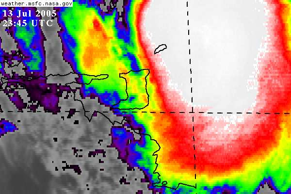
| - Situation Report #1 - TS/Hurr Emily impact on Windward Islands |
|
ISSUED BY: THE CARIBBEAN DISASTER EMERGENCY RESPONSE AGENCY (CDERA) DATE & TIME: July 14, 2005 12:00 noon THE EVENT: Tropical Depression #5 formed Sunday night July 10, 2005 and advisories were initiated by the National Hurricane Centre at 11 pm. At 5 am on July 11, 2005 the tropical depression was upgraded to Tropical Storm Emily which slowly strengthened to become a strong tropical storm as it approached the Windward Islands on the afternoon of Wednesday July 13, 2005. Around 8:45 pm July 13, 2005 data from an United States reconnaissance aircraft taking measurements in the tropical storm found that Emily had become a very strong Category One Hurricane with sustained winds of 90 miles per hour. Another measurement at 8:15 am July 14, 200 found an 11 millibar drop in pressure this morning, indicating that further strengthening is underway, however, the plane did not report increased wind speeds. The forecast track from initialization by tracking models on July 10, 2005 was for a gradual turn toward the west-northwest. Despite 11 advisories in the first three days to this effect, Emily stubbornly refused to turn but late Wednesday night July 13, 2005, a gradual turn started and has continued. The track brought the centre of Emily, then a Tropical Storm, about 125 miles south of Barbados, 90 miles northeast of Trinidad before passing over Grenada between 1 am and 2 am Thursday July 14, 2005 as a Category One Hurricane. The forecast track at 11:00 am Thursday July 14, 2005 is for Emily to pass south of Jamaica as a Category Three hurricane Saturday morning. Emily impacted Barbados, Trinidad and Tobago, St Vincent and the Grenadines, and Grenada. THE IMPACT (BY COUNTRY): Barbados No official information available Tobago 1. About 40 per cent of population lost electricity; 2. One northern town is without communication and cut off; 3. Two homes reported damaged or destroyed; 4. Another 16 homes sustained roof damage; 5. Seven roads reported blocked by fallen trees or debris; 6. Landslides reported in Lanse Fourmi. There is still heavy wind and rain in the area. 9:00 am; 7. One family was evacuated; 8. The hotels are all in good shape and open for business; 9. Martinair, Excel, and British Airways flights are operating according to schedule today. St Vincent and the Grenadines 1. Small number of homes sustained roof damage; 2. Shelters were opened and being utilized. Grenada 1. State of emergency remains in effect with a curfew from 7 pm to 6 am. Police are on patrol; 2. Eighty buildings were identified as emergency shelters of which 45 were used to house 1,650 persons; 3. Communication remained intact with the Emergency Operations Centre (EOC) and all of its District Coordinators; 4. Communication was also maintained and flowed well between the EOC and the media and then to the public; 5. Hardest hit areas were in the parish of St Andrew?s where houses in the villages of Seamoon, Pearls, Paradise, Marqui and Telescope were among those losing roofs; 6. A large number of houses in the northern parish of St. Patrick?s were also damaged. 7. Many homes were destroyed in Petit Martinique and Carriacou; 8. The hospital in Carriacou lost part of its roof and patients were taken into another section of the building; 9. The roof of the operating theatre of the main hospital in Grenada suffered water damage but was remained intact; 10. Part of the roof of the Police station in Petit Martinique was blown off; 11. Two Homes for the elderly, the Caudrona and the Hillarion lost their roofs; 12. The roof of the Sauteurs police station was blown away; 13. The eastern town of Grenville and parts of the outskirts of St.George are flooded; 14. Teams from the districts are being dispatched into the communities to carry out rapid assessment of the damage; 15. The Grenada Coast Guard has been put on standby to take damage assessment teams to Carriacou and Petit Martinique; 16. The works ministry has quickly mobilized crews to be dispatched to affected areas to commence recovery efforts; 17. Relief distribution has started to key areas; 18. The Prime Minister is expected to address the nation later today; THE RESPONSE (LOCAL, REGIONAL, INTERNATIONAL): Based on the information in Grenada and discussions with the National Disaster Coordinator the Regional Response Mechanism is at a Level Two Response. Level Two means that Grenada can largely handle the damage on its own but may require some external assistance. The Trinidad and Tobago Defence Force is conducting a surveillance flight with Grenadian emergency personnel and the Prime Minister of Grenada, Dr Keith Mitchell. The Eastern Caribbean Donor Group (ECDG) met at United Nations House in Barbados at 10 am July 14, 2005 and was informed that Grenada has declared a Level Two Disaster which means they can cope largely using their own resources but would require some external assistance. As a result there will be no need for the Rapid Needs Assessment Team. Pan American Health Organisation advised that a team of medical persons would be accompanying the Trinidad and Tobago Reconnaissance Flight to assess the damage to the Carricaou Hospital. Members at the ECDG indicated they were presently conducting their own assessments in the affected states where they had representative. This information be shared with the respective EOCs and with CDERA. Indications of immediate support available from these Agencies would also be communicated. These SITREPS will be shared with CDERA and a further update will be issued to the public as information becomes available. Information is also available at the Agency?s Website- http://www.cdera.org. |
| - EMILY |
|
|
Hello folks,
Well, it is now 7.45 pm and it seem as if the bad weather is over. It rained from around 11 am until around 6.30 am this morning. It has stopped raining, but it is still overcast, but the dark cloud covering is gone, and the light blue sky is trying to break through, in some areas.
Alot of areas throughout Trinidad are under water and lots of large rivers have overflowed their banks.
It seems as if Central Trinidad, Chaguanas, Enterprise, Edinburgh Gardens, are badly flooded, some parts of Arima as well.
The sea isa dark brown, and the currents are flowing very quickly, and sea is still choppy.
Hope that the day is better today.
Have not heard anything about Tobaga since my last report, or other parts of Trinidad.
Trini girl (Janice Camps)
Don't just search. Find. MSN Search Check out the new MSN Search! |
| - Almost over. | |
| |
No virus found in this outgoing message. Checked by AVG Anti-Virus. Version: 7.0.323 / Virus Database: 267.8.11/44 - Release Date: 7/8/2005 |
| - Trinidad Update |
|
East Trinidad 0720 LST or 1120 GMT Rain is only falling lightly now. Still overcast middle clouds and scattered low stratus fractus clouds. The wind is now very reduced to 3 to 5 km per hr. There have been reports coming in on the radio of flooding in City Gate area of Port-of-Spain, in the Santa Cruz area and parts of Central Trinidad. There have been some occasional reports of fallen trees. The Meteorological Office at Piarco have stated that the heavy rain and resulting damage have been caused by feeder bands emerging out of the hurricane itself. -- No virus found in this outgoing message. Checked by AVG Anti-Virus. Version: 7.0.323 / Virus Database: 267.8.14/48 - Release Date: 7/13/2005 |
| - Reports | |
| |
No virus found in this outgoing message. Checked by AVG Anti-Virus. Version: 7.0.323 / Virus Database: 267.8.11/44 - Release Date: 7/8/2005 |
| - Scorpion Emily. | |
| |
No virus found in this outgoing message. Checked by AVG Anti-Virus. Version: 7.0.323 / Virus Database: 267.8.11/44 - Release Date: 7/8/2005 |
| - Trinidad Update |
|
East Trinidad 0605 LST OR 1004 GMT Heavy continuous rain pounding Trinidad for the last two hours. Overcast low and middle clouds. Winds 15 to 20 knots. -- No virus found in this outgoing message. Checked by AVG Anti-Virus. Version: 7.0.323 / Virus Database: 267.8.14/48 - Release Date: 7/13/2005 |
| - EMILY |
|
|
Hello folks,
info on Trinidad -The Mamoral river, Piparo river all overflowed their banks, and authorities are telling all do not to out or use the roads. Flooding in D'abadie and Arouca.
The river in St. James overflowed its banks for a short time and water went into the stadium and the Red Cross, and the level in river went down and no longer over flowing..
Still raining heavy in South Trinidad, some thunder.
In Tobago , a person called into the Trinidad Gayelle TV station, Roofs blown off several houses and damages to infastructure, especially in windward area. 40% island without electricity.There was also a fire as a result of a tree falling on a electricity wire that caused a fire to a house, which was put out by the Fire Services, there are no cable services.
Bye for now - Janice Camps
Express yourself instantly with MSN Messenger! MSN Messenger Download today it's FREE! |
| - Emily in Tobago |
|
Good evening Gert, I am in Canada but just spoke to my sisters-in-law both in Speyside and in Les Coteaux at around 22:15. Power and phones were still on. The winds are coming from the West and Les Coteaux and the Plymouth side of Tobago seem to be getting more wind than Speyside and the windward side. They are experiencing gusts of 45 to 60 miles an hour but so far minimal damage has been done, at least in Les Coteaux and Speyside. The rainfall fluctuates but is mostly on now and has been heavy at times. This is the main concern in Speyside where they had landslides last week because of rain. If it doesn't get any worse, Tobago should be OK. Many people are of course concerned as they remember Flora's visit in 1963 which devastated the Island. I was told many times how the eye of the hurricane passed over Tobago and people spent months in tents before rebuilding. I hope this information is of some interest and help, please post it if you think it relevant. Thank you, Anne Trim |
| - emily | |
| |
|
| - Now Hurricane Emily (Trinidad- Tacarigua) |
|
Hello TS Emily is now classed as Hurricane Emily. Here in Tacarigua, on the southern side of the Northern Range, the foothills seem to be sheltering us from the gusty winds. Earlier there were bouts of heavy showers with thunder heard in intervals of approximately 15 minutes. This has now given way to a continuous moderate rain. TV and radio still up. Gayelle TV seems to be doing an allnighter! |
| - Emily (Hurricane) |
|
|
Hello again to all.
emailing from South Trinidad. It has been raining steadily over the last hour, light to moderate rain, and large raindrops, and it is now moderate to heavy, there is a stillness outside almost uneasy. There is a heavy low dark cloud coverage over land and sea. I am near the sea but it is so dark that I cannot see it properly, and the rain out there is very heavy and makes hard to see through.
No lightening now, but about an hour ago I saw sheet lightening over the sea but none since,and the wind was very strong, and the trees were swirling around. I have not heard any thunder down here.
Bye for now. Janice Camps - Trinidad Express yourself instantly with MSN Messenger! MSN Messenger Download today it's FREE! |
| - Fickle Emily | |
| |
No virus found in this outgoing message. Checked by AVG Anti-Virus. Version: 7.0.323 / Virus Database: 267.8.11/44 - Release Date: 7/8/2005 |
| - Trinidad Update |
|
East Trinidad 0015 LST or 0415 GMT Rain moderate continuous for the last thirty minutes. Overcast cloud cover with scraggly low clouds. Also a blanket of medium level altostratus covering the sky. No thunder heard, no lightning seen. Winds have pick up a bit, now about 8 to 10 miles per hour. -- No virus found in this outgoing message. Checked by AVG Anti-Virus. Version: 7.0.323 / Virus Database: 267.8.14/48 - Release Date: 7/13/2005 |
| - emily | |
| |
|
| - Trinidad Update |
|
East Trinidad 2250 LST or 0250 GMT Overcast low clouds, moderate rain. No thunder heard or lightning seen. Winds 5 Knots -- No virus found in this outgoing message. Checked by AVG Anti-Virus. Version: 7.0.323 / Virus Database: 267.8.14/48 - Release Date: 7/13/2005 |
| - Storm Watch on Emily | |
| |
|
| - Trinidad Update |
|
East Trinidad 2200 LST or 0200 GMT Rain has subsided significantly to a light dribble. No thunder heard. Wind even lighter now maybe 3 to 5 knots. Still overcast. -- No virus found in this outgoing message. Checked by AVG Anti-Virus. Version: 7.0.323 / Virus Database: 267.8.14/48 - Release Date: 7/13/2005 |
| - updating | |
| |
|
| - Trinidad Update |
|
2145LST or 0145 GMT Rain is now heavy. However the thunder frequency has reduced and still no sign of lightning. The wind is still light maybe 7 knots. -- No virus found in this outgoing message. Checked by AVG Anti-Virus. Version: 7.0.323 / Virus Database: 267.8.14/48 - Release Date: 7/13/2005 |
| - Trinidad Update |
|
2137 LST or 0137 GMT East Trinidad Rain has picked up significantly. Now moderate to heavy showers from low clouds shrouding the sky. Thunder booming much more frequently and somewhat louder. No sign of lightning close by. -- No virus found in this outgoing message. Checked by AVG Anti-Virus. Version: 7.0.323 / Virus Database: 267.8.14/48 - Release Date: 7/13/2005 |
| - That's it! | |
| |
No virus found in this outgoing message. Checked by AVG Anti-Virus. Version: 7.0.323 / Virus Database: 267.8.11/44 - Release Date: 7/8/2005 |
| - Trinidad Update |
|
2130 LST or 0130 GMT East Trinidad Light rain from overcast conditions with heavy low clouds and a layer of middle altostratus clouds. Constant thunder booming in the distance, maybe 10 kilometres away. Light wind of maybe 7 knots. -- No virus found in this outgoing message. Checked by AVG Anti-Virus. Version: 7.0.323 / Virus Database: 267.8.14/48 - Release Date: 7/13/2005 |
| - 8.30 p.m. | |
| |
No virus found in this outgoing message. Checked by AVG Anti-Virus. Version: 7.0.323 / Virus Database: 267.8.11/44 - Release Date: 7/8/2005 |
| - It's a hit | |
| |
|
| - Emily Em-ily EMILY. - First real rains | |
| |
No virus found in this outgoing message. Checked by AVG Anti-Virus. Version: 7.0.323 / Virus Database: 267.8.11/44 - Release Date: 7/8/2005 |
| - emily | |
| |
|
| - Emily from Trinidad |
|
3.35 pm Emily is estimated to be 175 km from Trinidad. Here in the east of Trinidad, although there is a quiet calm,there are ominous dark low clouds (mainly stratus fractus, cumulus fractus and heaped cumulus). There is no sign of rain at the moment, although it seems inevitable. There is a lot of traffic on the main highways and the main roads are people are trying to get out of the main cities and towns. Many people have stopped off at the grocery stores and stocked up on canned foods, bread and crix biscuits. There is a sense of anxiety pervading the atmosphere, since the government announced closure of all government offices, schools and most people are already home or on there way home. Keith Joseph -- No virus found in this outgoing message. Checked by AVG Anti-Virus. Version: 7.0.323 / Virus Database: 267.8.13/47 - Release Date: 7/12/2005 |
| - Update | |
| |
|
| - 2:15 pm | |
| |
No virus found in this outgoing message. Checked by AVG Anti-Virus. Version: 7.0.323 / Virus Database: 267.8.11/44 - Release Date: 7/8/2005 |
| - Home from work | |
| |
No virus found in this outgoing message. Checked by AVG Anti-Virus. Version: 7.0.323 / Virus Database: 267.8.11/44 - Release Date: 7/8/2005 |
| - what a day! | |
| |
|
| - Update | |
| |
|
| - Hurry Emily | |
| |
No virus found in this outgoing message. Checked by AVG Anti-Virus. Version: 7.0.323 / Virus Database: 267.8.11/44 - Release Date: 7/8/2005 |
| - Emily | |
| |
|
| - While we slumber | |
| |
No virus found in this outgoing message. Checked by AVG Anti-Virus. Version: 7.0.323 / Virus Database: 267.8.11/44 - Release Date: 7/8/2005 |
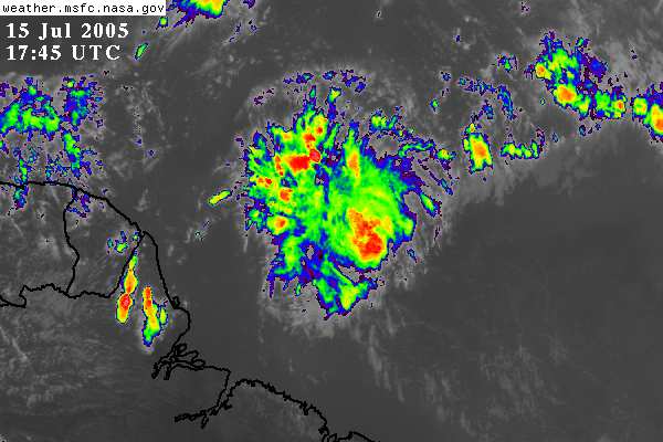
| - Strong Topical Wave approaching |
|
Hi Gert,
The  humidity is 70% and the temp is 30
The sky is an eerie grey and there is continuous rainfall,sometimes heavy
This is in Palmiste ,Trinidad on the south west of the island.
The satellite picture shows the rainfall concentrated to the nort east affecting first Tobago then Trinidad.We are bracing for landslides on the north! Dr Adesh Nanan _________________________________________________________________FREE pop-up blocking with the new MSN Toolbar - get it now! http://toolbar.msn.click-url.com/go/onm00200415ave/direct/01/ |
| - The season of large counter-rotating winds. |
|
Hello everyone,
                      I pray for the safety and preservation of all as we
begin the 2005 hurricane season. Last year Ivan passed really close but
Tobago got the worst of it between us.

With the mess this coutry is in, do we need a hurricane? What would
happen after the devastation? As I have said before our disaster
preparedness status.... is a disaster!

On a lighter note Trinidad is a lush green all over. We did not really
have a dry season this year. Interestingly last year was the same, food
for thought huh? Well, here we go. May God keep us all.

Robert Krucia
Port of Spain.


    [ Part 2: ""AVG certification"" ]

Internal Virus Database is out-of-date.
Checked by AVG Anti-Virus.
Version: 7.0.322 / Virus Database: 266.11.17 - Release Date: 5/25/2005
|
| - Y-Up & attem. | |
| |
No virus found in this outgoing message. Checked by AVG Anti-Virus. Version: 7.0.308 / Virus Database: 266.11.9 - Release Date: 5/12/2005 |
| - Yeah Gert! | |
| |
No virus found in this outgoing message. Checked by AVG Anti-Virus. Version: 7.0.308 / Virus Database: 266.11.2 - Release Date: 5/2/2005 |
| - 2005 hello. | |
| |
No virus found in this outgoing message. Checked by AVG Anti-Virus. Version: 7.0.308 / Virus Database: 266.11.2 - Release Date: 5/2/2005 |
| Back to top |