
|
|
- Updates from the Islands -- - the Bahamas - - |
|
|
Looking for someone? You can post your plea for help on Bahamas bulletin board
Map of the Bahamas can be found in the Bahamas Climatology Section
Bahamian News Websites: briland.com, Harbour Island and Eleuthera, some Cat Island; eleu.net, Spanish Wells and Eleuthera; CoconutTelegraph.net, all Abacos
Other bulletin boards are located at BahamiansOnline and Grand Bahama Online. For Abaco check out the Coconut Telegraph Board.
| - ABACO Recovering from Jeanne |
|
|
Well, Abaco made it through another one. But boy was this a rough one! Central Abaco, in particular Marsh Harbour got the brunt of this one, however, North Abaco took a good beating also. For once in as long as i can remember, i was lost for words after seeing the devastation. The eye of Jeanne passed over us the worst possible time - high tide. The tides swept through Marsh Harbor which is the main business sector on the island. foodstores, hardware stores, banks, eateries, marinas, you name it...took a good pounding from Jeanne. flooding was excessive, had it been rain water, some things might have been salvageable, but this time we took in the OCEAN...salt water. i'm just now writing because i'm on a visit to nassau. needed a change of scenery. i still don't have internet services yet. there are still many without power and telephone. there are still many with no homes to go to. Jeanne tossed boats ashore. She tossed vehicles into the sea. She uprooted buildings and trees. Roads have eroded. Docking facilities demolished. With winds so powerful she lifted roofs. Surges so strong that business establishments and homes, now have watermarks up to 4ft inside. It will take us some time to get back on our feet from this one...but we will. I took my eleven year old daughter on a tour after this one...to witness history. Most Abaconians have come to the conclusion that Floydd of 1999 was a joke compared to Jeanne of 2004. Sometimes it seems unreal when i think about it. Its like Jeanne decided, "Frances doesn't know what she's doing. Let me show her how its done!" What hurricane frances started, jeanne completed. And she did it with a bang!!! Pray for us! Anita.
STOP MORE SPAM with the new MSN 8 and get 2 months FREE* |
| - NEWS RELEASE: The Bahamas declares disaster areas in Abaco and Grand Bahama |
|
ISSUED BY: Caribbean Disaster Emergency Response Agency (CDERA) DATE: September 28, 2004 TIME: 1:00 pm Bridgetown, Sep 27, 2004 - The islands of Abaco and Grand Bahamas have been declared disaster areas by Prime Minister the Right Honourable Perry G. Christie. Both islands, in the northern Bahamas, sustained substantial damage from Hurricane Frances in August and Hurricane Jeanne last weekend. The Government has appealed for regional and international assistance to provide immediate emergency relief to the residents of both islands and also for the reconstruction which is to follow. |
| - Situation Report #1 - Hurricane Jeanne impact on The Bahamas |
|
ISSUED BY: Caribbean Disaster Emergency Response Agency (CDERA)
DATE: September 27, 2004
TIME: 2:00 pm

SITUATION UPDATE

The Event: Hurricane Jeanne impacted the northwestern Bahamas including the
Abacos, Andros Island, Berry Islands, Bimini, Eleuthera, Exuma, Grand Bahama
Island and New Providence September 25 – 26, 2004.  Storm surges, heavy rains
and hurricane/storm force winds caused wind damage and flooding as Hurricane
Jeanne moved across the Islands. Several areas were evacuated and thousands
weathered the storm in shelters


Preliminary Reports
The National Emergency Management Agency (NEMA) in the Bahamas has provided the
following initial report:

Abaco           Heavy flooding, Sandy Point suffered 1/3 water damage
                6-10 houses destroyed
                7-10 houses severely damaged

Grand Bahama    E.O.C sustained some damage
                Search & Rescue Teams rescued 13 persons including children
                Grand Cay extensive damage
                Roof damage reported
                Sweetings Cay suffered damage

Bimini          Experienced 8-10 feet seas
                Erosion at Beach front east Coast

Eleuthera       Experienced tropical storm conditions – winds 35-40 mph
                No major damage reported.
                3 feet of water in some areas
                Shingles lost from homes on Mainland

Berry Islands   Experienced winds 70-80mph, seas 5-6 feet high
                Most homes damaged from previous Hurricane are now leaking
                Flooding in low lying areas
                Major erosion to the Cause-Way
                Some damage to schools

Reconnaissance flights conducted on September 26 over Grand Bahama and Abaco
reported that airports/airstrips at Marsh Harbour, Sandy Point and Treasure
Cay, and Walker’s Cay are usable.

Teams are presently deployed to conduct preliminary assessment

Electricity and water have been restored to many areas

All Roads were cleared in Bimini

Supplies of water were airlifted to Moore’s Island

The CDERA Coordinator, Mr. Jeremy Collymore is presently enroute to the Bahamas
to meet with local officials and to receive first hand updates on the situation.

Further SITREPS on the situation in the Bahamas will be issued as necessary.
|
| - Hurricane Jeanne - Morning After |
|
Jeanne continued to roar through the night with strong southerly winds and driving rain, but as we awoke this morning we were very happy to see the damage was not near as bad as Frances. There are some poles down, some more roof tiles missing, additional water damage to rooms, we are without power and water but the rain has stopped, the sky is brightening, everyone is starting to clean up. All the boats and docks here at Ocean Reef made it through okay. Thankfully the water never rose more than a foot ot two beyond the high tide mark on the south side of Grand Bahama. Reports from friends who have been driving around town confirm this situation in other parts of Freeport as well. Let's hope this is the last storm this year! Vicki |
| - Hurricane Jeanne - live! |
|
7:45 pm EDT Freeport, Grand Bahama Don't ask me how we still have an internet connection!!?? Hurricane Jeanne is upon us now...exactly 3 weeks after the destruction of Hurricane Frances. Since early this morning the wind and rain has been non-stop and increasing in intensity. The winds started out NE but are now blowing from the SW, well over 100mph and it is high tide, which coupled with the storm surge has brought the water level near the top of the walls in our canals here on the south side. It is dark now so I cannot see too much more but the storm has not abated at all since about 4pm - continuing with heavy rain and a strong SW wind. All of the boats in the marina at Ocean Reef Yacht Club are holding well, but lines are worn from the last hurricane and the docks and poles as well. Daylight will tell if any of the boats have been damaged. The gray building lost most of its roof in Frances and the repairs have been coming along quickly. As of now, 7:50pm, the plywood repair is still holding, only the tarps have blown off which will add to the water damage in the rooms. The white townhouses are holding fine - that's where I am now. Our concern would be if the water level rose another 3 feet or so. The last satellite image I saw had the eye about 20 miles NW of us and moving away. Jeanne is moving at 14mph so hopefully she'll be past quickly. Here on Grand Bahama we were hit heavily by Frances...this can only make matters worse. Will update as able. Vicki at Ocean Reef Resort & Yacht Club Freeport, Grand Bahama www.oryc.com |
| - Jeanne Leaves New Providence |
|
Its after 8pm Saturday. The trees have been blasted again, but fewer fell down this time. Jeanne was a kinder lady than Frances, at least on this eastern side of New Providence. The wind seemed much less fierce. There was very little flying debris observed. All utilities are currently working properly at this end. Thats a welcom change from last time , with Frances when we lost everything for a while.Local news reports indicate that Grand Bahama and Abaco were very much battered by Jeanne. Our thoughts and prayers go out to all who need them. We are in this active hurricane season together. |
| - Hurricane Jeanne: Day After [Harbour Island & North Eleuthera] |
|
Early reports from Harbour Island and North Eleuthera suggest that Jeanne held to a more northern path than predicted ... ***** Ben Knox reports from Harbour Island: Hi all, Had a quick look outside just now and there is far less damage than after Frances. There are just a few small branches blown down here and there, and palm leaves dotted around on the ground. The beach doesn't appear to have been eroded any more. Overnight, the winds were certainly much weaker than Frances, and came initially from the Northwest, and then moved around to roughly Southwest. The power stayed on pretty much all night, until about 5 or 6am (it's still off at the moment - 9:20am). I haven't been into town yet. Things are calming down now, with periods of rain squalls and wind gusts. The phones seem to be working ok for incoming and outgoing calls. ***** Hurricane Jeanne Slams Bahamas on Way to Florida Noon - 25 September By Michael Christie MIAMI (Reuters) - Deadly Hurricane Jeanne strengthened rapidly as it crossed the northern Bahamas on Saturday on its way to deliver a record fourth hurricane strike in one season to densely populated Florida. Up to 3 million storm-weary Floridians were told to evacuate coastal islands, mobile homes and flood-prone areas. Others battened down the hatches one more time, stocking up on batteries, water and gasoline and shuttering homes, or streamed into public shelters. Many on the storm-scarred Atlantic coast, emboldened by having survived Hurricane Frances three weeks ago, vowed to remain at home, an act of defiance that alarmed authorities. As Jeanne's 115 mph winds, up from 105 mph overnight, and 8-foot storm surge lashed Great Abaco island in the Bahamas, a 700-island chain of 300,000 people stretching from Haiti to off the Florida coast, U.S. officials urged residents not to be complacent. Gov. Jeb Bush said people living in Florida's coastal areas could not assume they could ride out Jeanne just because they had survived the previous hurricanes. "People on the barrier islands who think they can ride this storm out should think again," Bush, brother of President Bush (news - web sites), told reporters. "It is getting bigger and stronger." By 11 a.m., the storm, which has already killed up to 2,000 people in Haiti and 31 in the Dominican Republic and Puerto Rico, was just west of Marsh Harbour, Great Abaco, at latitude 26.6 north and longitude 77.6 west, or 155 miles east of Florida. Jeanne picked up speed overnight and was traveling westward at 14 mph. The U.S. National Hurricane Center (news - web sites) warned the storm, now a strong Category 3 on the five-step Saffir-Simpson scale of hurricane intensity, could strengthen further over warm water between the Bahamas and the southeastern United States. Along Florida's Atlantic coast, including the densely populated counties of Broward and Miami-Dade, 3 million residents were told to evacuate. MILLIONS IN HARM'S WAY State officials said computer models showed 4.7 million of the state's 17 million people were in harm's way, and estimated that 1.2 million buildings could be damaged, leaving around 142,000 families without homes. In some parts of the likely strike zone near Ft. Pierce in St. Lucie county, home owners have barely had time to patch over damaged roofs with blue tarpaulin, or to clear piles of tree limbs and debris left behind by Hurricane Frances, or the soggy remnants of Hurricane Ivan last week. "It's horrible. This is just unprecedented," said St. Lucie county emergency management spokeswoman Linette Trabulsy. When Jeanne comes ashore on Florida as expected late on Saturday or early Sunday, it will make history -- the first time since records began in 1851 that Florida has been walloped by four hurricanes in a single Atlantic storm season. The season lasts from June to the end of November. Hurricane Charley kicked off a season likely to dent the state's reputation as a tourist destination when it slammed ashore on the southwest Gulf Coast on Aug. 13 as a Category 4 storm -- the second most powerful. It had winds of 145 mph, killed 33 people and caused $7.4 billion in insured damages. Frances, a weaker but much larger storm with 105 mph winds, spread destruction along the Atlantic coast on Sept. 5, killing 30 and causing $4.4 billion in damages. Ivan, at one point the sixth most powerful Atlantic hurricane ever recorded, ripped into the Gulf Coast between Florida and Alabama with 130 mph winds on Sept. 16, killing at least 45 people across the United States and causing up to $6 billion in damages. "It's all part of living in Florida. You live in California, you deal with earthquakes. You live in Texas, you deal with drought and fire. You live in Kansas, you deal with tornadoes. I'd rather live somewhere it's warm," said Broward county emergency management spokeswoman Alinda Montfort. In the Bahamas, residents of Grand Bahama and Great Abaco islands, both still recovering from the ravages of Frances, packed into shelters. Silbert Mills, chairman of Abaco's disaster preparedness committee, said there was a feeling of "ubiquitous melancholy" on the island in the face of the approaching storm. (Additional reporting by Frances Kerry in Miami, Michael Peltier in Tallahassee and John Marquis in Nassau, Bahamas) ------------------------------------------------------------------------------------------------------- The Briland Modem <www.briland.com> ------------------------------------------------------------------------------------------------------- News and Information for Harbour Island & North Eleuthera, Bahamas ------------------------------------------------------------------------------------------------------- [It's much better in the Out Islands.] - Coordinates: 25°30'N 76°38'W ------------------------------------------------------------------------------------------------------- Support the Briland Modem Fund, a 501(c)(3) community development initiative: http://tinyurl.com/25ka6 |
| - Jeanne , A New Providence Experience |
|
Its after 8am Saturday morning. The sky is hazy gray. The wind has picked up a bit, causing trees to bow and sway. There is continuous rain...........varying in intensity from a light spray to a pelting downpour. Here at the eastern end of the island we still have all utilities. Folks here are shuttered up and just waiting for Jeanne to hurry up and get out of here. ZNS TV is conducting a phone survey of the islands, speaking to various persons in the islands and finding out what the status and conditions are on the islands. We continue to take all neccessary precautions, and to pray for all those affected by this active hurricane season. |
| - Hurricane Relief Desk Opens [Nassau Guardian] |
|
Hurricane relief desk opens 24 September 2004 By RAYMOND KONGWA, Guardian Staff Reporter House repairs, rent, financial and food assistance make up the hardship relief Government is extending to certain groups affected by Hurricane Frances. Minister of Social Services and Community Development Melanie Griffin announced Thursday that a Hurricane Relief Desk had been set up in the Department of Social Services "to assist qualified old age pensioners, persons with disabilities and other persons with limited income who are incurring hardship due in the aftermath of Hurricane Frances." The relief desk would receive and process applications; follow-up on referrals to ensure appropriate distribution; and partner with private sector groups to provide additional aid. The following were listed as requirements for eligibilty: * All applicants must be 18 years or older * Applications for assistance must be related to Hurricane France. * Old age pensioners, persons with disabilities and other persons without sufficient income to affect repairs or replace losses occasioned by the hurricane. * Applicants must own and occupy the home for which requests are made for repairs * Applicants must be without hurricane insurance coverage * Applicants must be suffering genuine hardship due to damages and/or losses sustained from Hurricane Frances The Minister said teams from various government agencies had conducted door-to-door assessments in badly affected Grand Bahama and Family Island Communities. However in cases where persons were missed, applications could be made to Department offices in the respective districts. Persons affected in New Providence were advised to make application at the following locations: * Clarence Bain Building, Thompson Boulevard (tel 326-0526, 326-0451) * Munnings Building, Nassau Street (tel 322-7121) * National Insurance Building, Wulff Road (tel 356-9391) * National Insurance Building, Fox Hill (tel 364-7224) The deadline for applications is Friday Oct. 29, 2004. The assessment process began Sept. 6 and has been completed in North Andros, The Berry Islands, Cat Island and San Salvador, Mrs Griffin announced. ------------------------------------------------------------------------------------------------------- The Briland Modem <www.briland.com> ------------------------------------------------------------------------------------------------------- News and Information for Harbour Island & North Eleuthera, Bahamas ------------------------------------------------------------------------------------------------------- [It's much better in the Out Islands.] - Coordinates: 25°30'N 76°38'W ------------------------------------------------------------------------------------------------------- Support the Briland Modem Fund, a 501(c)(3) community development initiative: http://tinyurl.com/25ka6 |
| - Update |
|
Hello There From Nassau The Bahamas, Well here we go again another hurricane. It has been frantic out there. The shops are full, the gas station have long lines and you cannot move for the traffic. I really feel for the people of Grand Bahama, as they have not recovered from Francis and they are facing another one. I just want to let them know we have not forgotton them and we will be thinking and praying for them and after this is over we will do what we can to help. SO far the sun is still shining . Will keep in touch as long as possible God Bless Angela CUlmer _________________________________________________________________ Protect your PC - get McAfee.com VirusScan Online http://clinic.mcafee.com/clinic/ibuy/campaign.asp?cid=3963 |
| - Information Note #2 - Hurricane Jeanne threatens the northern Bahamas |
|
ISSUED BY: Caribbean Disaster Emergency Response Agency (CDERA) DATE: Sep 16, 2004 TIME: 5:00 pm --------------------------------------------------------------------------------------------- 1. Hurricane Jeanne which passed over Haiti as a Tropical Storm and killed more than 1,000 people is now headed towards the northern Bahamas where a hurricane warning is in effect; 2. The Emergency Operations Centre in the Bahamas is still activated. The National Emergency Management Agency has advised that particular attention is being placed on the Abacos and Grand Bahama Islands where it is anticipated that flooding is likely to be the main hazard. Persons on these islands have been advised to evacuate low lying coastal areas and to go into shelters. Teams deployed during the response to Frances are still on the ground in these islands and are being used to support the preparations for the impact of Jeanne. Recovery Centres which were established following the impact of Hurricane Frances will also be available to assist residents as necessary; 3. A Hurricane Warning is in effect for the northwestern Bahamas which includes the Abacos, Andros Island, Berry Islands, Bimini, Eleuthera, Grand Bahama Island, and New Providence. A Hurricane Warning means that hurricane force conditions are expected within the next 24 hours; 4. Grand Bahama Island was hit the hardest by Hurricane Frances three weeks ago and the international airport on the island was destroyed; 5. A Tropical Storm Warning is in effect for the central Bahamas which includes Cat Island, the Exumas, Long Island, Rum Cay, and San Salvador. A Tropical Storm Warning means that tropical storm conditions are expected in the warning area in the next 24 hours; 6. San Salvador was the island over which the eye of Hurricane Frances passed three weeks ago but the infrastructure was able to withstand Frances' poweful winds; 7. At 5 pm the center of Hurricane Jeanne was located near latitude 26.4 north and longitude 73.5 west or about 225 miles east of Great Abaco Island. Jeanne is mvoing westward as 12 mph which would cause the hurricane to make landfall on Saturday. Maximum sustained winds are near 100 mph making Jeanne a Category Two hurricane on the Saffir-Simpson Scale. Hurricane force winds extend outward to 45 miles and storm force winds up to 150 miles. The National Hurricane Centre says that up to 10 inches of rain is possible along the path of Jeanne; 8. The CDERA Coordinating Unit in Barbados remains on 24-hour call to respond should The Bahamas request support; 9. Updated information on the hurricane track and forecasts as well as situation reports from The Bahamas can be read at www.cdera.org |
| - Abaco Bracing for Jeanne |
|
|
It's now 4:35pm and the change in weather is becoming more noticable with more frequent spats of rain and occaisional wind gusts. Currently the few stores that are still open are still crowded with persons purchasing last minutes supplies. For the most part, Abaco has prepared themselves as best they can, considering that both Frances of two weeks ago and Floyd of five years ago are STILL FRESH on everyone's mind. Will keep you posted.
Add photos to your messages with MSN 8. Get 2 months FREE*. |
| - Jeanne Update - Gregory Town, Eleuthera |
|
Hurricane Jeanne Update Friday, September 24, 2004 North Eleuthera - Bahamas Jeanne is fast approaching. Clouds are a dark boiling mass to our northeast, and winds have picked up in the last few minutes and are gusting from 25-30 mph. Rain bands are coming in consistent intervals, with the breaks in between decreasing as each new band arrives. The seas on the Caribbean side are heavy and coming out of the west. Tighten up everyone. Live from Gregory Town, this is Kimberly Morgan. ------------------------------------------------------------------------------------------------------- The Briland Modem <www.briland.com> ------------------------------------------------------------------------------------------------------- News and Information for Harbour Island & North Eleuthera, Bahamas ------------------------------------------------------------------------------------------------------- [It's much better in the Out Islands.] - Coordinates: 25°30'N 76°38'W ------------------------------------------------------------------------------------------------------- Support the Briland Modem Fund, a 501(c)(3) community development initiative: http://tinyurl.com/25ka6 |
| - Hurricane Jeanne | |
| |
|
| - Hurricane Jeanne, NOT Welcome in The Bahamas!! |
|
Sure, we say " Welcome to the Bahamas" but that doesn't mean storms!! Lady
Jeanne, the "Turn-Back Hurricane" is on the way back. In New Providence,
there is a cool, moderate breeze dancing in the air. At the Yamacraw Beach
area,the Go-Slow Bend and at Arawak Cay, the white capped waves crash
against the shore . Passing motorists are sprayed with seawater, and even
small rocks tossed up by the waves.
   A check of some hardware stores revealed that hurricane supplies were
still moving quickly off the shelves. I was unable to find C cell batteries,
slide bolts, shingles in several stores. People in Nassau are still making
repairs from Frances. Some, unable to get materials or workpersons, have
made temporary repairs with sheets of plywood, plastic, tarps etc. Shutters
remain installed on several buildings. In my area, homeowners removed some
shutters but have them nearby for quick installation. Piles of  post
hurricane debris lay in yards and along the roadsides awaiting removal.
    Residents that I have spoken to indicate that they have been at
semi-alert status since Frances. They learned from all the stress that came
from getting prepared for Frances. Water, canned goods, and other
preparations remain secure .
     I also spoke with some persons with friends/relatives in Grand Bahama.
Water, food, hygiene products, roofing materials etc. are still in short
supply. Various service groups and  corporate citizens in several islands
have started hurricane relief drives to assist those most affected by
Frances.
      Let us continue to  pray for those already affected during this storm
season, and for those yet to be touched.
|
| - Eleuthera |
|
|
Well here we go again! I am back in my cave! Eleutherans are prepared once again for a little "Blow". In fact it's beginning to get pretty windy outside, the sea's have been choppy and higher then normal for a couple of days now as we await Jeanne's arrival. Actually most never removed their storm shutters, and the ones that did had left the close by for quick replacement. It seems that this is an exceptional season, some speculate due to global warming.... (you tink?).
I have had enough for one month! Hurricane anxiety for sure!, first Frances gets us moving,( she moved me, literally, I never knew glass could bend like that!), then Ivan kept us on our toes, (and in our caves), then Jeanne did a drive by, decided she wasn't ready, Karl kept his distance and Lisa still can't make up her mind!
This will be my 2nd hurricane, funny how I am already ready! New shingles, new sheet rock, most everything important still packed up, go figure.... My digital camera was a casualty of Frances, but I got the good old SLR for back up, film, batteries, water jugs full. gas tank full, picking up the rum in the morning! Enough already!
I realize that hurricanes are no laughing matter, they are deadly and destructive. I was quite scared during the hight of Frances. The sound of the wind was like standing next to a speeding freight train. And why did she have to come at night... Impending doom, like swimming in the cloudy sea, you know the shark is there, somewhere...
I weathered my first hurricane with my good friend McGyver in the bomb shelter, we were the best survivors! This time McGyver is flying the coop for a few weeks, so I am solo, but being through basic training already I will be a brave trooper!
I believe that Eleuthera, as much damage as she sustained from Frances, overall, was quite lucky. No loss of life! Shingles and sheet-rock can always be replaced.
I pray for all who meet Jeanne's wrath, stay safe, high and dry! __________________________________________________ |
| - Hurricane Jeanne | ||
| ||
__________________________________________________ |
| - From Abaco |
|
|
Here in abaco we're bracing ourselves for another one. Most residents have not recuperated from hurricane Frances, but are none the less preparing as best they can for Jeanne. Major problem here after Frances was leaking roofs, water damage, and yes, despite some of the reports you've heard, there are a few people who lost just about everything - resulting from collapsed houses. As we prepare ourselves for Jeanne, pray with us. I'm located in Central Abaco where the brunt of the business sector of the island is located. As i speak, foodstores are busy, hardware stores as well. There are some in despair because they haven't been able to even begin repairs from the last hurricane...therefore...prepaing themselves for even more dammage to the existing now weaker structures. Thank God no lives were lost on the island! We're praying we can say the same thing after Jeanne passes. Will keep u posted. MSN 8 with e-mail virus protection service: 2 months FREE* |
| - Bahamas on alert for Hurricane Jeanne |
|
Posted on Thu, Sep. 23, 2004
237fc7a.jpg


Miami Herald
Florida, the Bahamas placed on alert for Hurricane Jeanne

By MARTIN MERZER
<mailto:mmerzer@herald.com>mmerzer@herald.com

Forecasters issued a tropical storm watch for the central Bahamas and
alerted residents of South and Central Florida this morning as Hurricane
Jeanne edged closer to the area. They predicted landfall somewhere in
Florida -- possibly South Florida -- by Sunday.

If so, Jeanne would become the fourth hurricane to strike the state during
this deadly, destructive and freakish hurricane season.

''It would be no surprise to see Jeanne reach major hurricane status in 48
to 72 hours . . .,'' said forecasters Jack Beven of the National Hurricane
Center in West Miami-Dade County. ``Given the forecast of the steering
currents, Florida should pay close attention to the evolution of Jeanne.''

He said the storm, already responsible for more than 1,000 deaths, mostly
in Haiti, was expected to begin a steady approach toward the Bahamas and
Florida.

This morning's official forecast showed the core of a Category 2 hurricane,
with 110 mph winds, coming dangerously close to the area between Palm Beach
and Vero Beach -- the same region struck by Hurricane Frances early this
month -- veering north and making landfall around Cape Canaveral.

Forecasters emphasized, however, that such forecasts constantly change,
that Florida's entire East Coast was in danger of a direct hit, and that
Jeanne's outlying effects were likely to reach much of the state.

The local forecast for South Florida called for increasingly cloudiness and
rain Friday night, with heavy rain and wind Saturday and Saturday night.

High surf and riptides already are sweeping South Florida's coastline,
mostly in Palm Beach and Broward counties, and beach erosion has been reported.

At 5 a.m EDT, a tropical storm watch was issued for the central Bahamas,
including Cat Island, the Exumas, Long Island, Rum Cay and San Salvador. A
tropical storm watch means that tropical storm conditions are possible in
the watch area within 36 hours. Forecasters said a hurricane watch could be
required for the northwestern Bahamas later today.

Meanwhile, Ivan returned -- call it Ivan2.

A resilient piece of Hurricane Ivan, the storm that viciously assaulted the
Gulf Coast last week, looped over the Atlantic, passed over Florida,
returned to the Gulf of Mexico, redeveloped into a tropical storm Wednesday
and was punching the Louisiana and upper Texas Gulf Coasts with rain and
wind this morning.

The center of reborn Tropical Storm Ivan was expected to make landfall near
the Texas-Louisiana border tonight.

-------------------------------------------------------------------------------------------------------
The Briland Modem
<www.briland.com>
-------------------------------------------------------------------------------------------------------
News and Information for Harbour Island & North Eleuthera, Bahamas
-------------------------------------------------------------------------------------------------------
[It's much better in the Out Islands.] - Coordinates: 25°30'N 76°38'W

-------------------------------------------------------------------------------------------------------
Support the Briland Modem Fund,
a 501(c)(3) community development initiative:
http://tinyurl.com/25ka6
|
| - After Frances Update |
|
Date: Tue, 21 Sep 2004 21:03:38 -0400 From: Gaye Albury <sgaye_AT_batelnet.bs> I will try to be specific on each inquiry that I have read on the site. Abaco received minimal structural damage to buildings, mostly loss of shingles and plenty water damage to homes and businesses. Little Harbour is o.k. saw some of the residents and they are all fine. I believe Pete is away at this time. Hope Town/Elbow Cay received a lot of sand blasting the area near White Sound was almost cut in two again. Fortunately there were no deaths or serious injuries. Nassau had minimal damage as the strong side of the hurricane was north of it. Grand Bahama and especially Freeport and West End was devastated. I am told that there were no more than three homes standing in West End. Things are beginning to come together for Freeport, essential services are being slowly restored. The islands south of us fared much better than Abaco and Grand Bahama as Frances stalled over us for 30 plus hours and we had 25-30 inches of rain. If you want more specific answers I will try to get them for you. Jack |
| - Hurricane Frances | |
| |
|
| - Hurricane Frances | |
| |
|
| - On the path of Jeanne, Karl [Nassau Guardian - 17 Sep 2004] |
|
Friday, September 17, 2004 <http://www.thenassauguardian.com/national_local//national_local/281470675418218.php>Hurricane <http://www.thenassauguardian.com/national_local//national_local/281470675418218.php>Jeanne Southeast Islands prepare By TAMARA McKENZIE, Guardian Staff Reporter Given only two weeks to revive from the blow dealt by Hurricane Frances, residents in the South-East Bahamas are somewhat baffled that a third hurricane is on the verge of hitting The Bahamas, They, however, are taking the necessary precautions to ensure safety of life and property. A hurricane warning remained in effect on Thursday for the Turks and Caicos Islands and islands in the South-East Bahamas. These islands include: Great Inagua, Mayaguana, Acklins, Crooked Island, Ragged Island and the Semana Cays. A hurricane watch was issued for the Central Bahamas, which includes Long Island, San Salvador, Rum Cay, Exuma, the Exuma Cays, Cat Island, South Eleuthera and South Andros, while a hurricane alert was issued for the remaining islands in the North West Bahamas. These include: New Providence, North Eleuthera, North Andros, the Berry Islands, Bimini, Grand Bahama and Abaco. Hurricane alerts are issued in stages of: Alert, Watch, and Warning. An Alert lets residents know that storm conditions could be affecting parts of The Bahamas within 60 hours. A Watch is carried out when a storm is less than 36 hours away and a Warning is when a storm is less than 24 hours away. As of 5:00 p.m. Thursday, Jeanne, the tenth named storm for the 2004 Hurricane season, was downgraded to a tropical storm with highest winds near 70 miles per hour with gusts that could increase to hurricane force. Director of Meteorology, Arthur Rolle, said Jeanne had the potential to intensify once it moved over waters into the South-East Bahamas. Like Frances, forecasters are predicting that Jeanne would follow the same path as Hurricane Frances, which touched every island in The Bahamas. The coordinates as of 5:00 p.m. placed Jeanne near Latitude 19.9 degrees north and Longitude 69.3 degrees west or 200 miles south east of the Turks and Caicos Islands, 290 miles, east south east of Inagua and 670 miles south east of New Providence. Jeanne was moving toward the west, near eight miles per hour and a turn to the northwest was expected overnight. Mr Rolle mentioned that Jeanne, a category one hurricane on Wednesday, moved over mountains of Hispaniola and lost its strength. He added, however, that the system is back over water and may have regained its strength last night. Mr Rolle said residents in the South-East Bahamas should try and minimise whatever losses they can, having recently experienced the effects of Hurricane Frances. "We do not feel that they have overcome their ordeal, but we are hoping that they can do whatever they can to save whatever they can from potential flooding," he said, adding that Jeanne will bring more rain showers than Frances, therefore "considerable flooding" is expected in the southeastern islands. According to the met director, September is the peak month for hurricanes, and to have several storms repeatedly formed within weeks, is not unnatural. He informed that as of today, another tropical depression may have formed, and another unnamed system is moving off the coast of Africa. Turks and Caicos On Thursday evening, residents in the Turks and Caicos had already battened down their homes and were stocking up on bottled water and other shelf items. According to the Met Office, the island should have experienced some hurricane force winds last night and early this morning. The Minister responsible for the Department of Disaster Management, Karen Delancy, said Hurricane Frances give Turks Islanders a good "exercise call" in terms of preparation, although the island was not directly hit. "What we got was some wind and rain, but with Hurricane Jeanne, we are anticipating rain and lots of water, especially in our low lying areas and we may see some flooding," she said Mayaguana Mayaguana Administrator, Samuel Miller said as of Thursday, preparations were already in place on the island in anticipation of Jeanne. He said many of the residents did not remove their hurricane shutters since Hurricane Frances, therefore there was not much work to do in terms of securing houses. "We have just completed a tour of the entire island along with NEMA local representative and the chief councilor to ensure there is full compliance," he said, adding that residents are concerned about having to brace themselves for another hurricane in such a short period of time. He said residents are waiting for supplies to carry out cosmetic work as a result of Hurricane Frances, and another hurricane may result in further damage to some certain structures. Long Island Long Island Administrator, Preston Cunningham, also mentioned that residents had "little to do" in terms of preparation for Hurricane Jeanne, as shutters remained battened to windows since Hurricane Frances. He also mentioned that two mailboats arrived at the island on Wednesday, therefore residents were able to secure basic items to prepare for the storm. Mr Cunningham said since the passing of Hurricane Frances, Long Islanders seem to be more alert and are not taking any chances. He said they now realise that these storms can be "tricky" and can develop strength as they move. He added, however, that he had already touched base with shelter managers on the island and they were making sure that all shelters were ready and available. Ragged Island Ragged Island Administrator, Granville Hepburn was attending a meeting to discuss Hurricane Jeanne at the time he was contacted by The Guardian. He mentioned that everyone on the island had already battened up and all shelters were ready to be occupied. "We are just going through the motions here now and bringing the people together once again to let them know the seriousness of this situation," he said. Meanwhile, The Bahamas Government is trying to come to grips with the devastation left behind by Hurricane Frances, especially on the island of Grand Bahama where hundreds were left homeless. Parts of the island still remain without electricity and telephone services, however, the government, The Bahamas Red Cross and other organisations and businesses have shipped food items and water to the island. The government also reactivated the Disaster Relief Fund, which was initially established in 1992 as a result of the Hurricane Andrew's devastation. The fund gives immediate relief to those requiring the most assistance after a hurricane. It has been recently reactivated on several other occasions for national disasters - Hurricane Floyd in 1999 and Michelle in 2001. The fund is chaired by the Minister of State for Finance James Smith and the Regional Director of the Royal Bank of Canada Ross McDonald. ------------------------------------------------------------------------------------------------------- The Briland Modem <www.briland.com> ------------------------------------------------------------------------------------------------------- News and Information for Harbour Island & North Eleuthera, Bahamas ------------------------------------------------------------------------------------------------------- [It's much better in the Out Islands.] - Coordinates: 25°30'N 76°38'W ------------------------------------------------------------------------------------------------------- Support the Briland Modem Fund, a 501(c)(3) community development initiative: http://tinyurl.com/25ka6 |
| - Tropical Storm Jeanne | |
| |
|
| - TravelWeekly Frances Update |
|
Source: Travel Weekly's Caribbean E-Letter - http://travelweekly.com Sept. 16, 2004 HURRICANE IVAN ripped through the Caribbean last weekend and is scheduled to make landfall somewhere along the Gulf Coast today. Tropical storm Jeanne, nearing hurricane strength, eyed the northeastern Caribbean on Wednesday. Meanwhile, relief efforts are underway for the Cayman Islands, Grenada and Jamaica; information is posted on each destination's Web site: www.caymanislands.ky; www.grenadagrenadines.com; and www.visitjamaica.com. In addition, the Caribbean Tourism Organization [www.onecaribbean.org] and the Caribbean Hotel Association [www.caribbeanhotels.org] have spearheaded relief efforts. Caribbean Star Airlines launched an initiative with a number of musicians who recorded a song dedicated to Grenada; proceeds from the sales of the CD and $2 from each Caribbean Star ticket sold in the next two months will be earmarked for Grenada relief. Cayman Airways is operating emergency relief flights on a limited basis into Grand Cayman; Air Jamaica flew 30,000 pounds of supplies into Kingston, Jamaica, on a special relief flight Sept. 13. The airport there, as well as in Montego Bay, Jamaica, is open for business. HERE'S A PARTIAL RECAP throughout the region: i Bahamas . Club Med Columbus Isle on San Salvador, Bahamas will reopen Dec. 18 when it completes storm repairs from Hurricane Frances -- remember that one? * ** *** Gert van Dijken ( gert@vandijken.com ) **** Caribbean Hurricane Network - http://stormcarib.com/ |
| - Update |
|
Nassau The Bahamas Hello There, I cannot believe it yet again another hurricane ,we have recovered from our experiences and now off we go again!!!.The food store was busy and once again we are searching for water.I really feel for the people living on Grand Bahama island . I just hope and pray that we donot get to much rain!!Famous last words. Will keep in touch. A.Culmer _________________________________________________________________ MSN 8 helps eliminate e-mail viruses. Get 2 months FREE*. http://join.msn.com/?page=features/virus |
| - Here we go again! | ||||||
| ||||||
|
| - Still Frances... |
|
Found on the Pleas for Help forum:

    Re: Pictures and Word From Grand Bahama
   Author: johanna (---.7.3.213.fix.bluewin.ch)
   Date:   09-16-04 04:18

   The Freeport News is online again, since Sept 14.
   There were a lot of photos in the printed edition of Sept 14, you can
   view them on-line n the pdf-edition:
   http://freeport.nassauguardian.net/
   Online PDF
   "Jump to Edition" pick "September 14"

   for "Words from Grand Bahama"
   Go to the Geographia/Grand Bahama Forum.
   http://www.geographia.com/guestbook/gbahama/ (or
   http://f27.parsimony.net/forum67650/)

   Use the search function to find info about a particular place or
   person. If you can't find it, post a message to "Janice" who is a
   wealth of information.
   hope this helps


*
**
*** Gert van Dijken ( gert@vandijken.com )
**** Caribbean Hurricane Network - http://stormcarib.com/
|
| - Hurricane Jeanne - 11:00a 16 Sep 2004 |
|
11 AM AST THU SEP 16 2004 ...HURRICANE WARNING ISSUED FOR SOUTHEASTERN BAHAMAS AS JEANNE SCRAPES THE NORTHERN COAST OF THE DOMINICAN REPUBLIC... AT 11 AM AST...1500Z...THE GOVERNMENT OF THE BAHAMAS HAS ISSUED A HURRICANE WARNING FOR THE SOUTHEASTERN BAHAMAS...INCLUDING THE ACKLINS...CROOKED ISLAND...THE INAGUAS...MAYAGUANA...AND THE RAGGED ISLANDS...AS WELL AS FOR THE TURKS AND CAICOS ISLANDS. AT 11 AM AST...THE GOVERNMENT OF THE BAHAMAS HAS ALSO ISSUED A HURRICANE WATCH FOR THE CENTRAL BAHAMAS...INCLUDING CAT ISLAND...THE EXUMAS...LONG ISLAND...RUM CAY...AND SAN SALVADOR. AT 11 AM AST...1500Z...THE CENTER OF HURRICANE JEANNE WAS LOCATED NEAR LATITUDE 18.8 NORTH...LONGITUDE 68.7 WEST OR ABOUT 80 MILES... 130 KM...EAST-NORTHEAST OF SANTO DOMINGO IN THE DOMINICAN REPUBLIC. JEANNE IS MOVING JUST NORTH OF DUE WEST NEAR 7 MPH ...11 KM/HR. A WEST-NORTHWESTWARD MOTION IS EXPECTED OVER THE NEXT 24 HOURS. ON THE FORECAST TRACK...THE CENTER OF JEANNE IS EXPECTED TO REMAIN NEAR OR JUST INLAND OF THE NORTHERN COAST OF THE DOMINICAN REPUBLIC FOR MUCH OF THE NEXT 24 HOURS. MAXIMUM SUSTAINED WINDS ARE NEAR 80 MPH...130 KM/HR...WITH HIGHER GUSTS. JEANNE IS EXPECTED TO WEAKEN TO A TROPICAL STORM DURING THE NEXT 24 HOURS AS A RESULT OF ITS ENCOUNTER WITH HISPANIOLA...BUT SHOULD REGAIN HURRICANE STRENGTH ON FRIDAY. ------------------------------------------------------------------------------------------------------- The Briland Modem <www.briland.com> ------------------------------------------------------------------------------------------------------- News and Information for Harbour Island & North Eleuthera, Bahamas ------------------------------------------------------------------------------------------------------- [It's much better in the Out Islands.] - Coordinates: 25°30'N 76°38'W ------------------------------------------------------------------------------------------------------- Support the Briland Modem Fund, a 501(c)(3) community development initiative: http://tinyurl.com/25ka6 |
| - Hurricane Frances | |
| |
|
| - Watch IVAN!! |
|
|
Good afternoon!
First of all, big big thoughts for all the people living in Grenada. Also lots of prayers for those in Jamaica. This dirty thing is terrible!
A quick note to let you know that I wouldn't be surprised if we get some outer bands of clouds here in the Bahamas, with perhaps some gusts of wind.. Andros would be the mostly exposed right now. It's still a bit early to tell what we can expect precisely, but I would really suggest to everyone living in the Bahamas, especially in the Central and North Western parts, to keep a close eye of Ivan's evolution.
Better to stay alert in this period of the year; it looks like this season is really going to be long...
Take care, I wish you all a good recovery; I know it's going to take some time for a lot, but life must go on!
Créez gratuitement votre Yahoo! Mail avec 100 Mo de stockage ! Créez votre Yahoo! Mail Le nouveau Yahoo! Messenger est arrivé ! Découvrez toutes les nouveautés pour dialoguer instantanément avec vos amis. Téléchargez GRATUITEMENT ici ! |
| - News From Freeport | |
| |
|
| - Frances Update |
|
NEW PROVIDENCE Frances has left the country . The awesome task of clean up has begun around the nation. New Providence, where the capital of Nassau is located, suffered moderate damage to some buildings. Houses near Go-Slow bend were flooded and washed with sand. Large trees were uprooted or broken up all over the island. Fortunately the island was subjected to less intense conditions than some of the others. Utilities : Power , telephone and cable services have been restored to a large portion of suscribers. We are currently on water restriction , with water pressure being significantly reduced at times. Transportation : Nassau Airport is open for business again. Businesses have , for the large part reopened. The local bus ( Jitney) system is running regular routes. Misc. A large crowd was observed at one hardware and lumber business on Prince Charles, where homeowners gathered to purchase good for home repair. The Malls were also full of storm weary residents, purchasing supplies , but also getting more back to school shopping done. Schools: Government schools remain closed, while damage assessments and repairs are conducted. Some private schools will open later this week .The College of The Bahamas Nassau Campus reopened today. One of the local papers , The Nassau Guardian. provides a good overall review of the affected islands. You can check their online edition for details , thenassauguardian.com Hotels: So far I have heard no news about major damage in any of the larger (50 rooms +) hotels. They are open for business and eager to have guests. GRANDBAHAMA There was severe flooding and property damage in West End, resulting in the emergency evacuation of residents.Telephone service to the island is currently being restored.The airport was flooded and damaged. Reports are still coming from all over the Bahamas. |
| - San Salvador, Bahamas |
|
|
Our current was restored Monday evening and our internet dish was up and running this morning. We had plenty of messages and dealt with family and friends first.
Hurricane Frances passed directly over San Salvador at 3.00pm on Thursday. The calm of the 'eye' lasted 80 minutes. What an experience! Our island, even though so small [at 12 miles by 5] was effected variably. The settlement of United Estates [pop. 700] on the north end of the island suffered both the north east and, after the 'eye' the south winds directly. No injuries reported, but some homes were destroyed and most received partial or total roof loss; the two schools badly damaged. This is a disaster area and government have already surveyed damage and will be providing assistance. The west coast settlements faired alot better; some destruction but mostly minor roof damage. No roads or seawalls were damaged and power poles stood up well. The Electricity corporation cut power off on Thursday morning and have been very prompt in returning current, as the few poles are put back up, to the Cockburn Town area and to Long Bay,
Sugar Loaf and the south; excellent service.
The storm passed over all the islands facing the Atlantic; Cat Island, Eleuthera and we understand worst hit Abaco and Grand Bahama where flooding and surge played a larger factor.
Your correspondent has faired well. Our house is in good shape. The yard is wrecked but coconut trees remain standing. We estimate some 6-8 inches of rain fell and more since so we hope the natural vegetation will recover quickly. I guess 60% of leaves were blown away. We see new shoots on bushes and trees already. Birds have survived and bugs too. We have a plague of frogs. Yes, we have mosquitos!
Do you Yahoo!? Read only the mail you want - Yahoo! Mail SpamGuard. |
| - Nassau Guardian: Island-by-Island Update |
|
FRANCES' FURY VANESSA C. ROLLE,Guardian Staff Reporter If "hell hath no fury like a woman scorned," then someone must have made Hurricane Frances really mad. Frolicking around The Bahama Islands with a beating stick packed with fierce winds and rain, Frances acted like a woman stalking a bad man. She was an unruly tourist who aggravated Bahamians by staying for a whole week, destroying things that really did not belong to her. And linger she did with winds up to 135 miles per hour and moving at 16 miles per hour, then 6, then four,...it seemed as if she stopped to have a few daiquiris and conch fritters at the Fish Fry - Twin Brothers probably - before making her way out of the archipelagic chain. Name any inhabited island of The Bahamas, and Hurricane Frances made the trip - knocking down lamp poles, flooding streets and homes, drumming on rooftops with heavy rain showers, and pummeling windows and walls with winds that seemed to have Samson's DNA. Frances was furious, and likewise are thousands of Bahamians who have been left without electricity, water, telephone service - after they almost depleted their bank accounts having to buy food, plywood, and batteries. One would think the locals would be thankful for several days off, but I think if the majority could have been stuck in their regular weekend party spots, they wouldn't have wanted Frances to leave. But for the families of those who perished and received injuries as a result of the hurricane, I'll bet they wished that they could have turned back "the hands of time." The hurt is fathomless, and the price of Frances' arrival too great. The family of 18-year-old Kenrad Delaney, who was electrocuted trying to repair a generator during the hurricane, is probably feeling something far greater than the rest of the country can ever imagine. But the nation today is filled with compassion and love for them, for the pain of not having electricity or telephone service can never compare to the loss of a life. Yes, the Bahama Islands took a good whippin' from Hurricane Frances, but as history records, we can bounce back even better.....and better.....and better. She really was a strong and mighty woman who tried knocking everything out of her way...on her way to Florida when she finally decided to become a tropical storm. Go figure!! According to a report by the National Emergency Management Agency (NEMA) on Saturday, in New Providence, apart from there being no electricity and telephone services, trees were blocking Dumping Ground Corner and Fox Hill Road, and trees and poles were also down in Montagu. The roof caved in at the Bethsada United Missionary Baptist church, and persons had to be moved to the Calvary Deliverance shelter. Traffic lights were hanging dangerously at some intersections, but that didn't make a difference because everyone was advised not to be on the streets. In Freeport, Grand Bahama, Queen's Cove was totally underwater, and personnel had to be taken to higher ground. Persons were also advised to evacuate low lying areas. The airport was under six-foot of water; 500 persons were evacuated from the Hawksbill area, adding to the 1,200 persons who occupied the shelters. In fact there was a massive evacuation effort from the low-lying areas. There was much roof damage in certain areas, and electrical and telephone services came to a halt. One person was also reported missing on that island. In West End Grand Bahama, a rescue effort was conducted at Homes Rock and West End due to flooding. Electricity poles were down, and there was no telephone service. The roof was blown off from the barracks at Hanna Hill, and the area of the Fishing Hole was completely flooded. Residents of Queens Cove - as well as weather personnel - had to be evacuated . One person was also reported missing. The island of Abaco, thankfully, did not have any loss of life, but ironically, a part of the roof used as the Emergency Operations Center collapsed, causing minor injuries to occupants. In Sandy Point, there was flooding and property damage to roofs, and some roofs were blown off in the Crossing Rock area. There were also several persons injured after the Cooper's Town Clinic's roof collapsed. The injured were airlifted to the Princess Margaret Hospital on Sunday assisted by the United States Coast Guard. Preliminary assessments also revealed there was major damage in the Treasure Cay area. Many boats also broke away from anchors. There was also a tremendous amount of flood lines in various communities on the cays from Guana Cay to Little Harbour. In Acklins and Crooked Island/ Long Cay, the dock was washed away, and there was much flooding, fallen trees, and debris from sea surge. The utility poles were down in Chesters Bay. There was also Minor damage to the High School and the Government Clinic but no damage to the airport. In Harbour Island, there was flooding, fallen trees, and electrical lines were down. Although the shelters were full, damage to the roofs were reported. There was minor damage to the clinic, as the roof was leaking. In Central Eleuthera , the shelter at Governor's Harbour Primary school was closed, and occupants were moved to Worker's House. Phillip Bethel Shopping Center received major damage and had its roof blown off. Lawrence Griffin Esso Service Station's gas pumps and roof were blown away, and the police station at Governor's Harbour was under 10-foot of water and was evacuated. Some 300 persons had to be evacuated to various shelters. In South Eleuthera, there were six operational shelters, and there was no electricity in the area . The roof at Green Castle and Rock Sound schools were damaged. There was also minimum damage to government buildings. In North Eleuthera, there was general flooding, and Jane Bay Dock was underwater, making it impossible for residents to travel to the mainland. Queen's Highway was flooded, and North Eleuthera residents could not access South Eleuthera. There was flooding in the northern part of Cat Island, and several homes had minor roof damage. Coastal erosions and debris made the roads impassable. Residents had no electrical power nor telephone services. In Exuma, a portion of the roof at the Packing House in Mt. Thompson blew off, and the water supply ceased. In Bimini/Cat Cay, the Anglican school building which was used as a shelter had to be evacuated. Evacuees were housed in Bub Hall. Major roads were covered with debris. No damage was done to Government buildings or the clinics. North Andros experienced heavy winds which knocked utility poles and trees down. The island also experienced some flooding. The electricity was off in Morgan's Bluff. The oil barge broke away from the mooring, running aground in the cove. Long Island also experienced some flooding from a four-foot storm surge. There were also power outages. In Inagua, there were sunken boats at Government Dock, and the roads were filled with debris. Trees were down in Mayaguana, but a matter of real concern was that the main road leading to the major dock had a crack that spanned 100-150-foot , 2-3-foot wide and 2-3-foot deep. The roads were blocked because of the fallen trees. There was a potential for flooding in San Salvador at Halls Landing near the sea wall. There was major damage to some of the homes. Approximately 100 homes were damaged, leaving five families homeless. Sixty homes were partially damaged. One house was completely destroyed. Eighty per cent of Club Med's roof was moderately damaged, and there is an estimated $60,000 damage at the field station. The primary and the high schools have been damaged. Shelters were operational with 98 per cent of United Estates staying in the shelter. At the St James Baptist church in North Victoria, some 50 percent of the population stayed at the shelter. Two government schools were damaged, and power and phone lines were down. |
| - Finally power and the internet!!! |
|
Report from Nassau, New Providence. Thank you everyone who showed concern and sent wonderful wishes and prayers it was truely appreciated. It was a pretty scay expereience which was made easier by the 24 hour coverage fron ZNS radio.It gave us a true picture of exactly what was happening.We did not suffer much damage just some shingles and we consider ourselves very lucky as Grand Bahama really suffered especially as it lingered for so long.We heard reports of families being stuck on roofs and their roofs collapsing. People sufferd lacerations and one of the ministers actually stayed with his constituents in a dangerous part of the island as it was by the water to support them. I heard many people leaving the safety of their shelter to try to assist those in distress. So I am grateful that our experience was not that harrowing and we pray for those In the family islands A. Culmer _________________________________________________________________ STOP MORE SPAM with the new MSN 8 and get 2 months FREE* http://join.msn.com/?page=features/junkmail |
| - Nassau Tribune - 'Bahamas Eyes Second Storm' |
|
Bahamas Wary Of Ivan In The Wake Of Frances [Nassau Tribune] Stunned Bahamians just getting over the shock of Hurricane Frances are being urged to keep a close eye on Hurricane Ivan. With floods still preventing planes from landing in Freeport, a view from the air was the closest that could be managed yesterday. Nassau got off lightly in Hurricane Frances compared with the nation's second city, Freeport, which has been one of the worst hit areas, suffering severe devastation. The Tribune flew over Grand Bahama and Abaco yesterday to survey the damage. With airports closed, harbours damaged, roads flooded, power lines down and telephones cut off, many settlements in both Grand Bahama and Abaco have been isolated from each other, and the islands are cut off from the outside world. Stunned Bahamians just getting over the shock of Hurricane Frances are being urged to keep a close eye on Hurricane Ivan, a category four storm that could make its presence felt in the Bahamas as early as Friday morning, the Met Office reported yesterday. Source: The Tribune |
| - Frances aftermath - water supplies in Nassau and Freeport | |
| |
|
| - Nassau Frances aftermath | |
| |
|
| - FW: Gregory Town, Eleuthera |
|
-----Original Message----- From: William J. Coates [mailto:wjc@offshorerisk.com] Sent: Monday, September 06, 2004 09:05 To: 'Gert van Dijken' Subject: RE: Gregory Town, Eleuthera Spoke with Eleuthera. Electric still out as are phones. Glass Window bridge intact but road North of bridge strewn with debris. Suspect most boulders and big stuff. If I can get over I will take my backhoe up and clear it away., but I am in the Keys and bracing for Ivan, the Terrible. Will advise more soonest. William J. Coates (wjc@offshorerisk.com) Offshore Risk Management www.offshorerisk.com Click here for contact information No coverage is bound or in force unless confirmed in writing by this office |
| - Gregory Town, Eleuthera | |
| |
|
| - Please tell us it's OVER!!!!!!! |
|
|
Hey you all.
Here in Nassau people are trying to get back to their routine, with a big cleaning needed... All the opinions are the same: we've been very lucky.
A lot of thoughts for the other islands of the Bahamas, as well as Florida, which have experienced a really bad time, much worse than we did here on New Providence.
OK... Some news... I guess you all now what I want to talk about: IVAN...
Find attached the warning number 14 from the NRL Monterey... I don't like the path indicated.
As of tonight, I've heard and read that it's already a cat 4! (Will have to check on that.) I wish this one stays South, we don't need another one in the Bahamas (this DOESN'T MEAN that I wish the Leewards get hit of course!).
All our thoughts and prayers now for them; get prepared on time, I can tell you it makes a lot of difference in the way it can affect you.
TAKE IT SERIOUSLY, AND GOOD LUCK!!!
Créez gratuitement votre Yahoo! Mail avec 100 Mo de stockage ! Créez votre Yahoo! Mail Le nouveau Yahoo! Messenger est arrivé ! Découvrez toutes les nouveautés pour dialoguer instantanément avec vos amis. |
| - Exuma |
|
---------- Forwarded message ---------- Date: Sun, 5 Sep 2004 06:44:20 EDT From: Crwslw AT aol.com You might want to post the following message from my big sister Barbara on Highborne Caye in the Exumas: From: barbara <highborne AT earthlink.net> To: dotef AT juno.com Date: Sat, 4 Sep 2004 07:32:11 -0400 (GMT-04:00) Subject: Francis Mom..please forward this to everyone who you can, I can't get into my address book..it is 7:30am Sat..and it has died down to about 40mph and we will be moving home soon, but staying ready while watchin Tropical Storm Ivan..Update from paradise...8PM Friday night...Itmiliar?) until about 8pm last night when it changed course from 290 to 310 which made a difference of 40 miles by the time it got to us so we only caught the edge of the eye. Donwas well over 100mph around 7am and has switched all the way around and itseems to have stopped and is probably going to last all night? NOAA says it is entlessly ravaging and pummeling but we have been out and checked on things a couple of times and the staff houses and trailers are still standing and the power station and store are okay. The dock house is taking a beating and the north house is okay on the front side anyway. Cat and Dale at McDuffs are fine and Dan and Chad and Leroy. The Champaign Lady reports from the pond at Normans that the and boom. The houseboats didnas low tide at the worst so none of the boats in the harbour got to much damage...mostley canvass, hard tops, antennas and rub rail...no one hit the dock to hard as Ian helped them tie their boats up really well..POR and Arasay(the people went off on Thursday) were on the south dock... a small sail boat from Ship Channel with the owner is in #1 and on Thurs the Sea Dragon(a dive boat from Fl) Showed up with 8 tourist and their 4 dogs. They stayed on the boat on the north dock.. We moved into the new store bldg on Thurs at 6PM. Made little cubicles with the cabinets (still no shelves) for privacy, some doubles and some singles as there are 15 people, 3 dogs, 1 cat and 1 birdcely. There is a kitchen in the back room with enough food to feed an army, even popcorn and video, all the comforts of home including ac and internet to plot the course. Set up a head in the liquor room with buckets and sand..quite civilized, even has a door!! Hotel Francis.. We have taken lots of pics and I will send some later..Staying the night again to avoid injury so just finished dinner of beef stew(by Armour)and bread, chips & salsa, cheese & crackers, salad and ice cream with crumbled Twix for desert. See it headed toward all our friends in Florida. Thinking of you and wish you well..let us know how you fare..more later, love b |
| - Now that's the spirit!!!! |
|
"I received much more information about hurricanes from ZNS than any weather channel in the states, and the faith of the Bahamians is amazing ... and gives us all hope." -- Judie Reynolds, of Miss Eula's house beside The Harbour Lounge [Harbour Island] ------------------------------------------------------------------------------------------------------- The Briland Modem <www.briland.com> ------------------------------------------------------------------------------------------------------- News and Information for Harbour Island & North Eleuthera, Bahamas ------------------------------------------------------------------------------------------------------- [It's much better in the Out Islands.] - Coordinates: 25°30'N 76°38'W ------------------------------------------------------------------------------------------------------- Support the Briland Modem Fund, a 501(c)(3) community development initiative: http://tinyurl.com/25ka6 |
| - Briland.com, Eleu.net Regional News Online - 4 Sep |
|
Today's storm news from the scene: Sep 4th, 07:15p EST – From Ben Knox, on Harbour Island: As you haven’t been getting many reports from Harbour Island, I thought I would send you this. I took a drive around Dunmore town earlier today and also walked along the beach. From what I saw, there didn’t appear to be any major structural damage to building, mainly things like roof tiles coming off, and wooden verandas and fences have been broken or blown down. The roads seemed to have mostly been cleared, and people were getting on with clearing the fallen trees and branches from their properties and making repairs. I saw a few street lights smashed on the ground, and quite a lot of power lines and telephone lines trailing across roads. Trees and branches are down all over the place. On the beach, there has been a lot of erosion. Where there used to be sandy slopes down to the beach from properties and hotels, there are now ‘cliffs’ where the sand has been gouged out by the sea. Many of the wooden stairs from properties down to the beach have been damaged or have the lower sections missing. Also many of the palm leaf “umbrellas” along the beach have gone (though Coral Sands Hotel’s ones seemed to still be there). The beach does look very pristine now as all the old seaweed that builds up on it has washed away. Today has had some quite high winds still and big gusts from time to time. The winds seem particularly high along the beach where it feels like your legs are being sand-blasted when you walk there. The sea is still quite rough. There have also been also intermittent squalls of rain and it has been very cloudy all day. At about 5.30pm, we started having a thunder and lightning storm with periods of very heavy rain. Power is still out and phones still not working. Hope this is of interest. Regards, Ben Posted by: Sep 4th 2004, 05:26:08 pm - Fig Tree News Team Thanks for your patience. In the meantime, here are Eleuthera and Harbour Island-related excerps from CEDRA that offers general detail of the islands [the entire report can be read at the briland.com messageboard]: CEDRA Situation Report #4 - Hurricane Frances - Sep 4, 2004, 14:00 pm North Eleuthera - Affected by winds in excess of 100 mph. Power down. No land base phone contact with Spanish Wells, N. Eleuthera and S. Eleuthera as fiber lines broken. General environmental damage and structural damage. Harbour Island – Affected by 100 mph winds which caused widespread environmental damage and downed power lines. All public shelters filled. Roofing damage. No injuries reported. Roads impassable. Central Eleuthera - Governor's Harbour sustained heavy flooding and some structural damage. Hatchet Bay - heavy flooding and some structural damage, no electricity. South Eleuthera - General flooding and structural damage, no electricity. Sep 4th 2004, 01:26:08 pm - Fig Tree News Team Thanks for your patience ... as any word comes in, it'll be posted here. As it stands, there's a lot over cloud cover over the island right now, which is most certainly hampering any post-storm satellite communications. If you hear anything on your end, please post here or send to info@briland.com. More news later ... Eleu.net Deserted Beach News Fig Tree News Team at Briland.com and an awesome network of satcom/ham and cell correspondents ------------------------------------------------------------------------------------------------------- The Briland Modem <www.briland.com> ------------------------------------------------------------------------------------------------------- News and Information for Harbour Island & North Eleuthera, Bahamas ------------------------------------------------------------------------------------------------------- [It's much better in the Out Islands.] - Coordinates: 25°30'N 76°38'W ------------------------------------------------------------------------------------------------------- Support the Briland Modem Fund, a 501(c)(3) community development initiative: http://tinyurl.com/25ka6 |
| - CEDRA Report No. 4 - General Island News |
|
Hi, guys: I completely understand your frustration, but at this point there's really little point in inquiring about individual towns, properties until the communications kick back in, as we're feeding you all of the news as it comes in. Thanks for your patience. In the meantime, here's the latest report from CEDRA that offers general detail of the islands: CEDRA Situation Report #4 - Hurricane Frances - Sep 4, 2004, 14:00 pm The Event: At 11:00am Eastern Caribbean Time, Hurricane Frances was located near the Island of Grand Bahama in the Northwestern Bahamas. A hurricane Warning for the Northwestern Bahamas continues to be in effect. The Prognosis: Hurricane Frances slowed considerably overnight whilst continuing to impact the Northwestern Bahamas. It is expected to continue to drench the Northwestern areas with torrential rainfall for the remainder of today. The weather conditions in the central Bahamas continues to improve. Status of RRM: The Regional Response Mechanism is activated. Caribbean Disaster Relief Unit (CDRU) on Standby The Situation – BAHAMAS The following update was provided by the National Emergency Management Agency’s (NEMA) EOC at September 4, 2003: Mayaguana - Electricity has been restored to the island. Acklins/Crooked Island/Long Cay – Flooding, minor damage to High School, homes, and the Government Clinic. There is damage to the dock in Spring Point. Long Island - Power is intermittent. There are fallen trees and flooding. Clean up underway. Exuma - Weather conditions improving. Water supply restored. San Salvador / Rum Cay – Five families homeless, another 100 have sustained damage to their homes. Damage to two Government schools, and other Government buildings; localised flooding. Power out, phone lines down. No loss of life. North Eleuthera - Affected by winds in excess of 100 mph. Power down. No land base phone contact with Spanish Wells, N. Eleuthera and S. Eleuthera as fiber lines broken. General environmental damage and structural damage. Harbour Island – Affected by 100 mph winds which caused widespread environmental damage and downed power lines. All public shelters filled. Roofing damage. No injuries reported. Roads impassable. Central Eleuthera - Governor's Harbour sustained heavy flooding and some structural damage. Hatchet Bay - heavy flooding and some structural damage, no electricity. South Eleuthera - General flooding and structural damage, no electricity. Cat Island - No water, no light, broken gas lines. Environmental damage. North Andros - Utility poles are down, trees down, flooding, no injuries, no electricity. Electricity is now on in some areas AA Central Andros – Minimal impact. Telecommunication and electricity available. South Andros / Mangrove Cay - No major damages. Few roofs have loose shingles. One floating dock in Driggs Hill broke away. New Providence - Trees down blocking Dumping Ground Corner. Roof caved in at Shelter at Bethsheda United Missionary Baptist church, no injuries reported. Occupants moved to Calvary Deliverance Shelter. Cunningham closed off at Kemp Road across from Urich McPhee School Library. Mia Dean and Nay Dean (sister ships) aground at Rose Island. Two elderly persons aboard Mia Dean assisted by Defence Force (harbor patrol). Traffic Light Dangerously Hanging on Thompson Blvd. Corner West of Harbour Bay Centre Blocked by Trees. Trees and poles are down at Montague, number of electrical lines down in Fox Hill Area. Public Information Officer is working with the media to notify the public to continue to stay in doors until otherwise advised. Nassau International Airport - NIA is up and running. Flights are being accepted. Berry Islands - Power lines down and roof damage in Great Harbour Cay. Abaco - In Central Abaco strong winds and torrential rain. In South Abaco cell phones and land phones are down; there is no electricity, contact being maintained with NEMA via satellite phone. In North Abaco part of the roof at the Government building which was used as the EOC collapsed and caused minor injuries. There are no utilities in North Abaco. East Grand Bahama – No damage assessment as yet. West Grand Bahama - Flooding in West End; electricity poles are down and there is no electricity as well as no phones. Roof blown off from barracks at Hanna Hill. Fishing Hole completely flooded. Residents of Queens Cove had to be evacuated. Weather personnel hand to be evacuated. Freeport Grand Bahama - Windy 80 mph; Airport under six feet of water. Queens Cove under water; personnel taken to higher ground. West End and Queens Cove have no communication. Maurice Moore Primary has 150 persons in shelter. A few trees down; no power. North and South Bahama along with Trip Circle are now experiencing high water rise, now in process of relocating to Huge Campbell Shelter. Ragged Island - No damage to any critical infrastructure. Telephones lines are up; electricity is on, no flooding and very little rain. Bimini / Cat Cay – No damage reported. |
| - Nassau, Freeport [AP Wire] |
|
Gert, can you please tell the CEDRA folks that your board can't read attachments? Can the board repost the latest CEDRA report from the Bahamas, please? Thanks -- Kimberly FREEPORT, Bahamas (AP) -- Hurricane Frances ripped apart roofs, shattered windows and flooded neighborhoods as it raged through the Bahamas on Saturday, driving thousands from their homes before beginning a slow march toward the east coast of Florida. Frances appeared to be weakening, with forecasters downgrading it to a Category 2 hurricane as its sustained winds dipped to 105 mph. But because of its slow movement, at just 6 mph, it could strengthen again before reaching Florida, expected late Saturday or early Sunday. The slower-than-expected movement meant a long ordeal for Bahamians. Roaring winds blew down trees and toppled power lines, knocking out electricity. Buildings trembled, palms bent in violent gusts and street signs flew off poles. One man was electrocuted during the storm. Surging seawater flooded at least three neighborhoods in the Freeport area on Grand Bahama Island, emergency administrator Alexander E. Williams said. "We're hearing reports of flooding all over. We're trying to move people to safety," he said. Sharon Carey, a 43-year-old waitress, said she awoke Saturday morning with water knee-deep in her house as police going through the neighborhood banged on the door. The family grabbed passports, birth certificates and other documents and waded outside, where they said dozens of neighbors were evacuating holding whatever belongings they could salvage. "Everybody was starting to cry because we were scared," said Carey's 10-year-old daughter, Comerneich Williams. "It was terrible." The family drove to a hotel seeking shelter, then left when told it was full. They said they didn't know where they would go. The winds decreased a bit Saturday morning as the eye came very near Freeport. Forecasters warned of more heavy winds. It wasn't immediately clear how many were evacuated from flooded neighborhoods. "We're in the middle of our rescue operation. We're trying to save lives," police Superintendent Basil Rahming said. Authorities had urged those in low-lying areas to evacuate Friday, but some decided to stay put. About 1,100 people on Grand Bahama Island rode out the storm in shelters set up in churches and schools, said Williams, the emergency administrator. Similar shelters were open on other islands, and many Bahamians left vulnerable homes to move in with relatives. "I'm trying to save myself. I'm scared," said Elianise Jean, a 40-year-old Haitian immigrant who came with her six children to a shelter in a church outside Freeport. Streets were largely deserted Friday as people rode out the storm indoors in the capital of Nassau, which is home to about two-thirds of the archipelago's 300,000 people. Fallen trees, debris and downed satellite dishes littered roads in Nassau. There were scattered reports of looting, police said, including one man who broke into a gas station and another who tried to steal appliances from a store after winds ripped off part of its roof. Tourists at the 2,300-room Atlantis Resort on Paradise Island, outside Nassau, were moved into a conference room as a precaution. In Nassau, 18-year-old Kenrad Delaney was electrocuted Friday while filling a generator with diesel. The family heard a scream and found him on the floor. He died after being taken to the hospital, police said. Freeport, the country's second largest commercial center, has fewer high-rises than Nassau and its building are generally better built. However, when Hurricane Floyd blew through in 1999, it flooded neighborhoods, left the Grand Bahama airport underwater and closed hotels. The Freeport weather office at Grand Bahama airport was closed due to flooding. Nassau's Doctors Hospital treated about 40 people who suffered minor injuries during preparations for Frances, said Charles Sealy, vice president of operations. As Frances passed, patients and staff played board games and sang on a karaoke machine, he said. At 8 a.m., the hurricane's eye was very near Freeport and about 110 miles east of West Palm Beach, Florida. It was moving between the west-northwest and northwest at 6 mph. A hurricane warning was up for most of Florida's east coast, stretching more than 300 miles. Hurricane watches and tropical storm warnings were in effect for other areas. About 2.5 million residents were told to clear out -- the biggest evacuation request in the state's history. Forecasters said the brunt of the hurricane could hit Florida late Saturday or early Sunday, about three weeks after Hurricane Charley struck with 145 mph winds, causing billions of dollars in damage and killing 27 people. Meanwhile, the U.S. Coast Guard was searching for a Fort Lauderdale-bound pleasure boat that made a distress call 12 miles west of Bimini in the Bahamas. Three people were reported aboard when the boat ran into 9-foot swells. |
| - SITUATION REPORT #4 - Hurricane Frances |
|
Please find attached Situation Report #4 on Hurricane Frances |
| - Freeport [Grand Bahama] and Abaco, Bahamas [11:00p EST] |
|
11 PM EDT FRI SEP 03 2004 FRANCES SLOWLY APPROACHING GRAND BAHAMA ISLAND... ...HIGH WINDS AND HEAVY RAINFALL CONTINUE TO RAKE THE NORTHWESTERN BAHAMAS... A HURRICANE WARNING ALSO REMAINS IN EFFECT FOR THE NORTHWESTERN BAHAMAS. A HURRICANE WATCH AND A TROPICAL STORM WARNING REMAIN IN EFFECT FROM NORTH OF FLAGLER BEACH NORTHWARD TO FERNANDINA BEACH. A TROPICAL STORM WARNING REAMINS IN EFFECT FOR THE MIDDLE AND UPPER FLORIDA KEYS FROM SOUTH OF FLORIDA CITY SOUTHWARD TO THE SEVEN MILE BRIDGE...INCLUDING FLORIDA BAY. AT 11 PM EDT...0300Z...THE CENTER OF HURRICANE FRANCES WAS LOCATED NEAR LATITUDE 26.1 NORTH...LONGITUDE 77.8 WEST OR ABOUT 70 MILES ...110 KM...EAST-SOUTHEAST OF FREEPORT GRAND BAHAMA ISLAND. FRANCES IS MOVING TOWARD THE WEST-NORTHWEST NEAR 6 MPH ... 9 KM/HR...AND THIS GENERAL MOTION IS EXPECTED TO CONTINUE FOR THE NEXT 24 HOURS. HOWEVER...STEERING CURRENTS REMAIN WEAK AND SOME ERRATIC MOTION CAN BE EXPECTED. ON THE FORECAST TRACK...THE LARGE CORE OF HURRICANE FRANCES WILL CONTINUE TO MOVE SLOWLY OVER THE NORTHWESTERN BAHAMAS OVERNIGHT...AND WILL BE VERY NEAR THE FLORIDA EAST COAST BY LATE SATURDAY. MAXIMUM SUSTAINED WINDS ARE NEAR 105 MPH...165 KM/HR...WITH HIGHER GUSTS. THIS MAKES FRANCES A STRONG CATEGORY TWO HURRICANE. SOME FLUCTUATIONS IN INTENSITY ARE POSSIBLE DURING THE NEXT 24 HOURS. HURRICANE FORCE WINDS EXTEND OUTWARD UP TO 110 MILES...175 KM... FROM THE CENTER...AND TROPICAL STORM FORCE WINDS EXTEND OUTWARD UP TO 200 MILES...325 KM. A SUSTAINED WIND OF 81 MPH WAS RECENTLY REPORTED ON NORTH ELEUTHERA ISLAND. DURING THE PAST HOUR...HAM RADIO OPERATORS AT HOPETOWN ON ABACO ISLAND REPORTED WIND SUSTAINED WINDS OF 69 MPH WITH GUSTS TO 81 MPH AT HOPETOWN. THE SETTLEMENT POINT C-MAN STATION ON WESTERN GRAND BAHAMA ISLAND RECENTLY REPORTED A SUSTAINED WIND OF 59 MPH WITH A GUST TO 75 MPH...WHILE A SUSTAINED WIND OF 44 MPH WITH A GUST TO 52 MPH WERE REPORTED AT THE LAKE WORTH FLORIDA C-MAN STATION. THE ESTIMATED MINIMUM CENTRAL PRESSURE IS 960 MB...28.35 INCHES. A SHIP IN MARSH HARBOR RECENTLY REPORTED A PRESSURE OF 960 MB. STORM SURGE FLOODING OF 5 TO 12 FEET ABOVE NORMAL TIDE LEVELS... ALONG WITH DANGEROUS BATTERING WAVES...CAN BE EXPECTED NEAR THE EYE OF FRANCES ON THE NORTH SIDE OF GRAND BAHAMA ISLAND. STORM SURGE FLOODING OF 3 TO 5 FEET ABOVE NORMAL TIDE LEVELS CAN BE EXPECTED ON THE WEST SIDE OF THE OTHER ISLANDS OF THE BAHAMAS. COASTAL STORM SURGE FLOODING OF 4 TO 5 FEET ABOVE NORMAL TIDE LEVELS...ALONG WITH LARGE AND DANGEROUS BATTERING WAVES...CAN BE EXPECTED NEAR AND TO THE NORTH OF WHERE THE CENTER MAKES LANDFALL IN FLORIDA. RAINFALL AMOUNTS OF 7 TO 12 INCHES...LOCALLY AS HIGH AS 20 INCHES... ARE POSSIBLE IN ASSOCIATION WITH FRANCES OVER THE BAHAMAS. ------------------------------------------------------------------------------------------------------- The Briland Modem <www.briland.com> ------------------------------------------------------------------------------------------------------- News and Information for Harbour Island & North Eleuthera, Bahamas ------------------------------------------------------------------------------------------------------- [It's much better in the Out Islands.] - Coordinates: 25°30'N 76°38'W ------------------------------------------------------------------------------------------------------- Support the Briland Modem Fund, a 501(c)(3) community development initiative: http://tinyurl.com/25ka6 |
| - NASSAU UPDATE FRI 10:40 PM |
|
|
Things get better now. Still a;lot of wind, now coming from the South West. Still some risks of surge on the South now.
I've heard many things about the local situation, but at that point it's hard to precisely know the extent of the damages. One thing is now sure: we've been very lucky!!!
Some roads might be damaged / flooded; It'll be probably hard to citculate around the island tomorrow. We're getting some rain, which should continue for some more hours / days ?
I believe everyone is safe and in good health, apart from this one death reported earlier.
Don't forget to read the earlier posts on this section by the local authorities; they're pretty complete and very accurate.
Attached is a pic from taken at noon today... Things are much better now!
Thanks for all the e-mails I have received; i'll get back to you as much as possible individually when I get a real internet connection back...
Créez gratuitement votre Yahoo! Mail avec 100 Mo de stockage ! Créez votre Yahoo! Mail Le nouveau Yahoo! Messenger est arrivé ! Découvrez toutes les nouveautés pour dialoguer instantanément avec vos amis. Téléchargez GRATUITEMENT ici ! Friday 12.04 PM.JPG
|
| - One dead as Hurricane Frances moves through The Bahamas |
|
SITUATION REPORT #3 - Hurricane Frances ISSUED BY: Caribbean Disaster Emergency Response Agency DATE: September 3, 2004 TIME: 6;00 pm The Event: At 5:00pm Eastern Caribbean Time Hurricane Frances was approximately 90 miles East southeast of Freeport, Grand Bahama. . The north western Bahamas continues to be under a Hurricane Warning as Frances slowly travels west northwestward. The Prognosis: Frances has been affecting the central and north western Bahamas for the past 24 hours and is not expected to clear the area for another 24 hours. The Central Bahamas will gradually clear this evening into tonight as the hurricane warning for that area has been discontinued by the National Hurricane Centre. Status of RRM: The Regional Response Mechanism is activated. Caribbean Disaster Relief Unit (CDRU) on Standby The Situation - BAHAMAS *********************** Several islands of The Bahamas are still experiencing hurricane force and tropical storm force winds at 5:00 pm. Nassau – one person is confirmed dead. An 18-year old was outside in the height of the hurricane attempting to service a standby generator and was electrocuted. Roof of shelter at Bethsheda United Missionary Baptist Church caved in. People safely moved to neighbours. San Salvador – Hurricane Frances battered this island with 140 mph winds for 30 hours. 15 to 20 per cent of the housing stock has been damaged. Population is 1,000 people. Widespread environmental damage with fallen trees, power lines and utility poles – much of which was cleared for initial damage assessment. Health care facility is in good condition. A doctor, nurse, and official of the Bahamian Defence Force were pre-positioned and are assisting residents. All tourists at Club Med were evacuated and the hotel, which is empty, sustained roofing damage. New Providence is the headquarters of the Emergency Operations Centre of the National Emergency Management Agency (NEMA) - At 5 pm tropical storm force conditions were still affecting the island and expect to subside tomorrow. Initial reports of environmental damage and storm surge affecting coastal areas and cutting off coastal roads. Some homes have been flooded but assessment is difficult this evening. Acklins Island – Sustained damage to a marine docking facility and other coastal damage from battering waves. Acklins/Crooked Island/Long Cay - No major damage. Two Haitian boat people detained. Eleuthera – Winds in excess of 100 mph affected the island. Storm force conditions still affecting the island. Power is out. Harbour – Power out after island affected with winds in excess of 100 mph. Storm surge and inland flooding reported. All evacuation shelters are occupied. No reports of injury or death. Roads are impassable. Minor damage to health clinic roof. Inagua - Two vessels damaged. Mayaguana – Road infrastructure damage. No loss of life. Power should be restored by tonight or tomorrow morning. Long Island – No damage Exuma - Weather conditions improving. Water supplies restored. Black Point – Telecommunications down. Farmer’s Cay – Telecommunications down. North Eleuthera - Winds reported in excess of 100 mph. Power out. Fibre optic cable from North and South Eleuthera broken– no land-based contact with Spanish Wells. Central Eleuthera – No electricity and telecommunications down. No contact with the island. South Eleuthera – Tropical storm force conditions still exist. Damage assessment not possible at this time. North Andros – Tropical storm force conditions still exist. One property reported damaged. Full assessment not possible at this time. Central Andros – No known damage. Weather conditions mild. South Andros / Mangrove Cay – No reported problems Nassau International Airport - Heavy winds. Bahamasair Holdings Office roof and front portion was torn off making it accessible to the public. Airport Security is stationed at the site. Berry Islands – Heavy rains continuing. Assessment not possible at this time. Abaco – Winds becoming strong. 250 persons in public shelters. East Grand Bahama – Winds becoming stronger. About 130 persons in public shelters. West Grand Bahama – Weather is good. 240 persons in public shelters. Freeport Grand Bahama - Winds are picking up, continues to rain. 700 persons in public shelters. Ragged Island – No reported damage to any critical infrastructure. Bimini / Cat Cay - Winds 35-40 mph. Four shelters are operational. No significant damage, some fallen tree limbs. ACTIONS BY COORDINATING UNIT **************************** 1. Ms. Audrey Mullings, Deputy Coordinator, CDERA, is coordinating reconnaissance from Jamaica to The Bahamas in the morning. Estimates are that weather conditions will permit flight travel by 7 am Saturday. 2. A Caribbean Media Corporation team will be part of the CDERA reconnaissance and provide pool reports for the Caribbean media; 3. Another flight, coordinated by USAID/OFDA leaves Jamaica to transport the Prime Minister of The Bahamas and a Government delegation to survey the affected areas; 4. The CDRU is on standby for deployment to assist the Government of the Bahamas. Air Jamaica Express has graciously offered to transport 25 persons from Jamaica to the Bahamas free of cost if required. This facility will be used to transport the CDRU if it is required to deploy. The CDERA CU has conveyed its thanks and appreciation on behalf of the region to Air Jamaica for “its unhesitating readiness to support the Regional Response System” 2. The CDERA CU continues to issue advisories/sitreps on Hurricane Frances which may be viewed at www.cdera.org. The UN/OCHA Reliefweb service is also posting SITREPS at www.reliefweb.int FURTHER INFORMATION CONTACT: Mr Jeremy Collymore Coordinator, CDERA Tel: (246) 425-0386 Mr Donovan Gentles Preparedness and Response Manager, CDERA Tel: (246) 425-0386 Mr Terry Ally Public Education and Information Specialist, CDERA Tel: (246) 425-0386 Mr Carl Smith Director, National Emergency Management Agency, The Bahamas Tel: (242) 322-2805 |
| - Briland.com, Eleu.net Regional News Online |
|
Today's storm action through the eye and beyond: Fig Tree News Team AT 2 AM EDT...0600Z...THE EYE OF HURRICANE FRANCES WAS LOCATED BY RECONNAISSANCE AIRCRAFT AND RADAR NEAR LATITUDE 24.7 NORTH... LONGITUDE 75.7 WEST OR NEAR THE NORTHERN END OF CAT ISLAND. THIS IS ALSO ABOUT 310 MILES...495 KM...EAST-SOUTHEAST OF THE FLORIDA LOWER EAST COAST. 07:32:29 am Nice lady from James Cistern called into ZNS this morning reporting that her part of Eleuthera is just getting the eye right now at 7:30a – everyone is inside, everyone is fine right now … preparing for the worst, but wanting everyone to know that everyone is fine and safe inside and waiting the storm out. North Eleuthera/Harbour Island are reporting intense 120 mph winds -- South Eleuthera winds beginning to intensify as the eye passes north. The eye is over Central Eleuthera at this moment ... the general sentiment of everyone calling in from the Out Islands this morning to discuss their various situation ** flooding and high winds in Long Island, houses damaged in San Salvador, electricity and Internet access and cable out in Abaco, high winds in Cat Island ** is that of relief that things aren't worse. Posted by: Sep 3rd 2004, 02:17:12 am Fig Tree News Team Storm thankfully weakens to a Category 3 storm, with a more diffuse core, currently lingering about 40 miles south of Eleuthera. 07:44:02 am South Bar reports that the Harbour Island has been continually pounded with wind and rain since last night at 9, and it looks as though the eye is going over Spanish Wells in a couple of hours. There is no electricity but phones are presently working. The tide is going down so hopefully the surge will be less as the tide is down. The consensus to date is that Frances is not as bad a storm as Andrew but more in the line of Floyd. ** James Cistern just reported a few minutes ago that they're right in the middle of the eye (7:50a) ... and Warren Miller of Hatchet Bay called in this morning just to commend the ZNS 1 coverage countrywide. He says that things got rough last night, but Hatchet Bay folks ** unlike Governor's Harbour or James Cistern [or Harbour Island, for that matter, where the Vic Hum was packed from 5:00p forward :-)!] ** were staying inside and pretty well packed down for the storm -- so far so good. Stay tuned ... 09:37:13 am Kif Brown Just spoke with Sheril Saunders. People are out walking around while the eye passes. Understand Cookie[‘s garage] has sustained significant roof damage. 09:50:46 am Robert Arthur notes "from the eye" at 9:30s EST: Beach did "remarkably well" even the tiki huts at Coral Sands still up, and not too much erosion -- as far as they could tell from north of Pink Sands down to about Runaway Hill Club. Bayside, water up to top of the wall, and lapping over the street, but that's it now. Not over government dock. In the village, vegetation damage is about the extent of it, for now. When the eye passes, westerly winds from the rest of this storm will complete the story. Phone and power lines still up, some sagging, but in good shape generally. Bracing now for the other half..... 09:50:55 am Goombayboy posted: Eye of Frances over Harbour Island at 9:30am. Eye lasted 90 min in Governers Harbour. Governers reported worse winds after eye. Some roofs on Harbour are damaged, many trees down so far. 10:05:01 am Bahama Sharon posts: On NBC at 7:25 this AM, Friday, Michael Higgs gave a telephone interview and reported that at the moment the winds were 75 mph. Some roofs are gone and trees down but he was fine and so were his golf carts. The roof was off of the pre school. The backside of the storm was just approaching. He wished the people of Florida well as Hurricane Frances heads our way. 11:00:01 am Fig Tree News Team 40 miles northwest of Eleuthera now … AT 11 AM EDT...1500Z...THE CENTER OF HURRICANE FRANCES WAS LOCATED BY SURFACE OBSERVATIONS FROM THE BAHAMAS AND A RECONNAISSANCE PLANE NEAR LATITUDE 25.5 NORTH...LONGITUDE 76.7 WEST OR ABOUT 40 MILES...65 KM...NORTHWEST OF ELEUTHERA ISLAND AND 220 MILES EAST-SOUTHEAST OF THE FLORIDA LOWER EAST COAST. At about 11:30a EST, the backside of the storm winds started to kick in off Harbour Island, which means that local news may be somewhat minimal over the next several hours. Thanks for your patience. As information becomes available, we'll be in touch. Fig Tree News Team AT 2 PM EDT...1800Z...THE CENTER OF HURRICANE FRANCES WAS LOCATED BY SURFACE OBSERVATIONS FROM THE BAHAMAS AND A RECONNAISSANCE PLANE NEAR LATITUDE 25.7 NORTH...LONGITUDE 77.2 WEST...VERY NEAR THE SOUTHERN TIP OF GREAT ABACO IN THE BAHAMAS AND 200 MILES EAST- SOUTHEAST OF THE FLORIDA LOWER EAST COAST. Michael Pratt posts: 2PM-Jill Lorey reports eye passed 2-3 hours ago. They still have sustained winds around 100mph+. Cookie & Kathy Ross' roof was OK whne last checked. They are w/ Lorey's @ Fig Tree watching the yard disappear. Power out, but phones still OK. The worst is over. Fig Tree News Team It's official: AT 5 PM EDT...2100Z...THE HURRICANE WARNING FOR THE CENTRAL BAHAMAS HAS BEEN DISCONTINUED. We made it!!!!!!! More news later ... Eleu.net Deserted Beach News Fig Tree News Team at Briland.com and an awesome network of satcom/ham and cell correspondents ------------------------------------------------------------------------------------------------------- The Briland Modem <www.briland.com> ------------------------------------------------------------------------------------------------------- News and Information for Harbour Island & North Eleuthera, Bahamas ------------------------------------------------------------------------------------------------------- [It's much better in the Out Islands.] - Coordinates: 25°30'N 76°38'W ------------------------------------------------------------------------------------------------------- Support the Briland Modem Fund, a 501(c)(3) community development initiative: http://tinyurl.com/25ka6 |
| - NASSAU UPDATE FRIDAY 2:45 PM |
|
|
Hi all!
Well it seems the worst is passed now. Winds currently at approx. 50 mph, with gusts at 60-70. We don't exactly know if the wind should now calm or pick up again. Everyone still needs to stay in the shelters.
We expect heavy rains later today.
Last night, at 2:30 AM, we had to evacuate our rooms in the Radisson hotel Cable Beahc, as a measure of precaution. Have been in the hotel ballroom since.
Some tree damages; report of 1 death: an 18-year-old boy who got electrocuted while trying to start a generator.
Things should get better during the night.
Will keep you updated tomorrow.
Attached: 2 pictures of Balmoral island, located in front of the Radisson:
first one taken Thursday at 6:00 PM, second one taken today during the worst part of the Hurricane.
Take care, hope everybody else has been safe.
Stolidref
Pictures: |
| - Exuma |
|
Just a little update on Exuma...Went looking at the damage and for any people needing help....Looks like minor damage Island wide Shingles, trees, and such...We are very lucky...Most folks have power and phones... Four Seasons has trees down as well...Didn't go to Rolleville or further up Island nor over to Little Exuma but did speak to friends on Little Exuma and they are without power but have phones....Southside of the Island has lots of swells because the winds are blowing 17 gusting to 29...but we checked on a friends house on the Southside and all is well....Good luck Nassau. Connie Scott Giacobbe OPBAT Site Manager George Town, Great Exuma Bahamas (242)336-2186 Office (242)336-2187 Fax (242)357-0951 Cell |
| - Situation Report #2 - Hurricane Frances |
|
ISSUED BY: Caribbean Disaster Emergency Response Agency (CDERA) DATE: September 3, 2004 TIME: 11:00 AM = = = = = = = = = = = = = = = = = = = = = = = = = = = = = = = = The Event: At 11:00am Eastern Caribbean Time Hurricane Frances was located in the Northwestern Bahamas very close to the island of Eleuthera with maximum sustained winds of 115mph. It is forecast to approach the northernmost islands in the Bahamas where Hurricane Warnings are still in effect. The Prognosis: Hurricane Frances forward speed has slowed to near 9mph. This is resulting in longer periods of hurricane force sustained conditions in the islands of the Central Bahamas. Rainfall amounts are also increasing. Status of RRM: The Regional Response Mechanism is activated. Caribbean Disaster Relief Unit (CDRU) on Standby The Situation – THE BAHAMAS Reports early this morning from contacts within the National Emergency Management Agency (NEMA), USAID/OFDA, PAHO, a Florida State University team, deployed in The Bahamas, and HAM radio operators indicate that conditions are improving in the Southeastern Bahamas. Only minor wind damage was reported and no significant flooding. Many shelters are open and operational as residents heeded the advice to seek safety. Damage Assessment is underway in most of the islands where the weather condition has improved. USAID/OFDA has finalized standby arrangements with the Government of The Bahamas for an immediate flight after the all clear which will accommodate the Prime Minister, US Ambassador, OFDA, NEMA, CDERA and PAHO to gain first hand information on the scope and extent of any damages to the territory. A second flight is also on standby to accommodate damage assessment teams and transport supplies as necessary. The International Federation of the Red Cross & Red Crescent Societies (IFRC) has dispatched two disaster management specialists from their Pan American Disaster Response Unit (PADRU) to Nassau to assist the local Red Cross officials in shelter management. Other response personnel have been placed on standby for deployment. Actions By Coordinating Unit: 1. Ms. Audrey Mullings, Deputy Coordinator, CDERA, is in Jamaica to lead the regional initial assessment team to The Bahamas on Saturday, if required. 2. Air Jamaica Express has graciously offered to transport 25 persons from Jamaica to the Bahamas free of cost if required. This facility will be used to transport the CDRU if it is required to deploy. The CDERA Coordinating Unit has conveyed its thanks and appreciation on behalf of the region to Air Jamaica for “its unhesitating readiness to support the Regional Response System” 3. The CDERA CU continues to issue SITREPS and News Releases on Hurricane Frances which may be viewed at www.cdera.org. The UN/OCHA Reliefweb service is also posting SITREPS at www.reliefweb.int FURTHER INFORMATION CONTACT: Mr Jeremy Collymore Coordinator, CDERA Tel: (246) 425-0386 |
| - Harbour Island, Bahamas [1:00p EST] |
|
Fisherman Randall Johnson reports from Girls Bank, Harbour Island: Many trees sustained damage. Roof damage throughout the island was reported, with maximum damage to the beach, as a lot of sand was reported to be washed out. Phones are still up. Not as bad as Andrew and Floyd at all. The back part of the storm is going over the island at a reported 35mph to 40mph. Boats are still intact and on land. There is a lot of debris reported throughout the island, leaves off trees and trees uprooted. The tide was out at the storm’s height thanks to the moon, so not much in the way of flooding. ------------------------------------------------------------------------------------------------------- The Briland Modem <www.briland.com> ------------------------------------------------------------------------------------------------------- News and Information for Harbour Island & North Eleuthera, Bahamas ------------------------------------------------------------------------------------------------------- [It's much better in the Out Islands.] - Coordinates: 25°30'N 76°38'W ------------------------------------------------------------------------------------------------------- Support the Briland Modem Fund, a 501(c)(3) community development initiative: http://tinyurl.com/25ka6 |
| - FRANCES NASSAU BAHAMAS |
|
From: stolidref <stolidref AT yahoo.fr> Date: Fri, 3 Sep 2004 10:45 I just spoke with stolidref in Nassau, The eye is coming in 1 and half hour, wind expect 125 mph All the hotel's guest evacuated (2:00 am that night) in emergency places and are safe in the hotel's shelters No more power, no more TV no more phone (except cell phone) M.S. |
| - Exuma |
|
Well we are fine and are in coms with people across the Island this morning...we faired well thru out the night...trees down and such but well...will venture out shortly to check it out more after my coffee..priorities you know...power on the Island was spotty and at present is still out...we still are feeling the back side with winds around 40 mph gusts as of 8 am....but like a hangover will only get better as the day progresses...we did so well ourselves as we are inland...others on the North side had much more than we did...Thanks for the web site it's the best...Heart goes out to all Islands...we all will have our Islands back to norm soon... We can produce water around the 10,000 gal per day so that's what we will do is check all folks and make sure they have clean drinking water...Connie Scott Giacobbe OPBAT Site Manager George Town, Great Exuma Bahamas (242)336-2186 Office (242)336-2187 Fax (242)357-0951 Cell |
| - Eleuthera/Harbour Island 8:00a Roundup |
|
South Bar reports that the Harbour Island has been continually pounded with wind and rain since last night at 9, and it looks as though the eye will be going over Spanish Wells in a couple of hours. There is no electricity but phones are presently working. The tide is going down so hopefully the surge will be less as the tide is down. The consensus to date is that Frances is not as bad a storm as Andrew but more in the line of Floyd. ** James Cistern just reported a few minutes ago that they're right in the middle of the eye (7:50a) ... and Warren Miller of Hatchet Bay called in this morning just to commend the ZNS 1 coverage countrywide. [Anyone reading this can catch the live radio broadcast streaming live at BahamasIssues.com, see 'ZNS Live' link.] Miller says that things got rough last night, but Hatchet Bay folks ** unlike Governor's Harbour or James Cistern [or Harbour Island, for that matter, where the Vic Hum Club was packed from 5:00p forward :-)!] ** were staying inside and pretty well packed down for the storm -- so far so good. North Eleuthera/Harbour Island are reporting intense 120 mph winds -- South Eleuthera winds beginning to intensify as the eye passes north. The eye is over Central Eleuthera at this moment ... the general sentiment of everyone calling in from the Out Islands this morning to discuss their various situation ** flooding and high winds in Long Island, houses damaged in San Salvador, electricity and Internet access and cable out in Abaco, high winds in Cat Island ** is that of relief that things aren't worse. God bless ... |
| - Man-O-War report | |
| |
|
| - Nassau Thursday 9:00 PM |
|
|
Complete dark right now, so we can't see too well the sea. Wind North North East at approximately 30 mph.
All birds have disappeared since approx. 7:00 PM
We expect conditions to change a little bit faster now. 40-50 mph should start in 1 or 2 hours.
No rain yet.
At 7:30 PM, checked on the South West of the island; the sea was very calm, and wind picking up (always like that here: when it gets rough on the North, it's usually calm in the South, and vice versa)
Will keep you posted.
Créez gratuitement votre Yahoo! Mail avec 100 Mo de stockage ! Créez votre Yahoo! Mail Le nouveau Yahoo! Messenger est arrivé ! Découvrez toutes les nouveautés pour dialoguer instantanément avec vos amis. Téléchargez GRATUITEMENT ici ! |
| - Briland.com, Eleu.net Regional News Online |
|
Today in Harbour Island, Eleuthera, Cat Island: 7:00p EST Per local councilor Harvey Roberts, a visual inspection of Harbour Island's three-mile pink sand beach at 7:00p EST showed complete storm erosion. 6:00p EST ZNS is broadcasting right now that the Glass Window Bridge is sporting 30-feet waves and has been closed to all traffic. Further north in Eleuthera, the commercial dock at Three Islands facing Harbour Island is completely submerged, even though it's still high tide. 5:00p EST South Cat Island command control is reporting 110 mph winds there at 5:00p, well in advance of the storm's expected eye landfall at 8:00p this evening. 2:00p EST Governor's Harbour High School is being closed as an emergency shelter, thanks to a compromised roof. All residents are being transferred to Worker's House there. All day DaBahamianTing.com is streaming ZNS television and radio reports live. Once electricity in Nassau goes off, though, you'll have to head to BahamasIssues.com and catch the DaBahamianTing radio coverage from there. Their weather reports are the best that we have found that are specific to the islands of the Bahamas. 12:00p EST In Tarpum Bay, skies are completely overcast. Some rain has fallen for the first time from this hurricane. Wind gusts as a result of Frances are currently up to 50 to 60 mph in gusts. These gusts appear occasionally and then calm down again. *** Governor's Harbour has moved its local government storm shelter inland from its traditional location on the waterfront. Satellite communications are intact. *** The farmers in North Eleuthera have been busy drydocking boats and burying natural gas and other gas canisters in anticipation of flooding later tonight. *** Harbour Island has been without electricity since noon (power turned off as a precaution by BEC), but all local shelters are busy and the local government storm office is fully-manned. More news later ... Eleu.net Deserted Beach News Fig Tree News Team at Briland.com |
| - Exuma |
|
We are sitting it out in Exuma...No prob here... she is in San Sal now and we are getting about 40 mph...It's 4:23 and we had expected much worse we are greatful and surprised...We all still have VHF and are intouch with Locals and Boaters alike...We do have more to go...Try to get back with you later. Connie Giacobbe George Town, Great Exuma Bahamas |
| - Re: nassau new providence |
|
Nassau New Providence Thank you for al of the kind emails I have received it is good to know that people are out there thinking of us. So far not much to report. We had a squall and some wind at 1.00pm. But it is nothing to what we can expect at 2 am in the morning. As you can imagine we will not be sleeping and I will definately be on hurricane watch. It is very quiet on the streets as we all stay inside and watch and wait. My husband did say the sea was beginnig to churn. Thanks again will keep you posted A. Culmer _________________________________________________________________ Help STOP SPAM with the new MSN 8 and get 2 months FREE* http://join.msn.com/?page=features/junkmail |
| - Man-O-War Cay, Abaco | |
| |
|
| - Correction... |
|
|
Sorry, I realize I wrote it wrong:
First part: winds from the North to the South, approximately until Friday noon / early afternoon.
Second part: winds from the West to the East... And not the contrary...
But I think everybody will have figured out by looking at the graphic...
Talk to you all later
Créez gratuitement votre Yahoo! Mail avec 100 Mo de stockage ! Créez votre Yahoo! Mail Le nouveau Yahoo! Messenger est arrivé ! Découvrez toutes les nouveautés pour dialoguer instantanément avec vos amis. Téléchargez GRATUITEMENT ici ! |
| - Nassau Thursday 4:00 PM Update |
|
|
Hey!
Still nothing really significant here. Wind in between 10 and 15 mph. The sky starts getting a little more cloudy.
Please check the attached graphic on Frances's windfield. As you can see, Nassau will get some wind from the North, getting stronger and stronger until friday noon. In the afternoon, we then expect the wind to change and to come from the East. Nothing directly from the South, as Frances is still forecasted to pass a little bit North of New Providence.
You can keep an update of this graphic + great other informations on the following URL:
Keep thinking and praying for all those in San Salvador and Cat Island. They're in the middle right now!
Take care, will keep you posted.
Créez gratuitement votre Yahoo! Mail avec 100 Mo de stockage ! Créez votre Yahoo! Mail Le nouveau Yahoo! Messenger est arrivé ! Découvrez toutes les nouveautés pour dialoguer instantanément avec vos amis. Téléchargez GRATUITEMENT ici ! windfield.jpg
|
| - Nassau news 1:45 PM Thursday |
|
|
The sky is now cloudy. I'm in Cable Beach, north of the island. The sea gets a little dark. We just had a sudden heavy rain. Quickly gone.
The wind will now start picking up slowly. Big big thoughts for San Salvador right now, who's currently experiencing the worst.
It seems that the eye could be moving a little bit away from Nassau. We expect it to pass North of us (or on us) in 23 hours now. It's going to be a long night...
I don't know how long I'll be able to remain online; I'm now using an old dial-up connection, it's been long since I last browsed at 28 kbps... As soon as the phone system will be down, I won't be able to post.
Anyway, everybody here is finalizing the prep work and getting in their shelters.
The biggest concern, looking at the forecasts and experts talks, is about the surge. Water may climb high on the island. We'll see.
Every hotel has distributed an emergency evacuation plan to their guests in case of any problem, so whoever has friends / family in a resort, don't worry, they should be safe.
Attached is a pic taken minutes ago, at 1:45 PM. And this is nothing yet.
Créez gratuitement votre Yahoo! Mail avec 100 Mo de stockage ! Créez votre Yahoo! Mail Le nouveau Yahoo! Messenger est arrivé ! Découvrez toutes les nouveautés pour dialoguer instantanément avec vos amis. Téléchargez GRATUITEMENT ici ! IMG_1150.JPG
|
| - Re: nassau new providence |
|
Hi There, We live in Nassau,things are deteriorating a little right now and it is overcast. All through my neighbourhood there is the sound of saws and banging. We have received many phone calls and most people are ready. It is now the anticipation. It is very difficult to play the waiting game. The only consolation is that everyone is doing everything possible to ensure the island is ready. I had a call from Spanish Wells and it is like Fort Knox. One thing for sure is we are braced and ready. I like the fact that it is bringing everyone in the neighbourhood together, offering plywood and buckets for water. If you donot know your neighbours you do now. Will keep you updated A. Culmer _________________________________________________________________ Add photos to your messages with MSN 8. Get 2 months FREE*. http://join.msn.com/?page=features/featuredemail |
| - Update from Man-O-War Cay, Abaco | |
| |
|
| - nassau new providence |
|
Hi There, It is very scary waiting with anticipation for Hurricane Francis. The radio station ZNS104.9 has been brilliant giving up-to -date information and keeping in touch with the family islands. The Prime Minister has been on a number of times reassuring everyone that they are doing everything within their power for disaster preparedness. It had changed direction and looks like it is coming awfully close. My family has done everything to prepare. Will keep in touch A.Culmer _________________________________________________________________ The new MSN 8: smart spam protection and 2 months FREE* http://join.msn.com/?page=features/junkmail |
| - NASSAU UPDATE / Thursday morning |
|
|
Good morning.
A couple of hours to go now until we'll see the first signs coming. Still some hammering going around... Everybody is taking it very seriously.
No panic here on the island, which is good. Just some stress growing up. I know all the hotels should be now fully booked; yesterday evening, a TV report on ZNS indicated that a lot of the Lyford Cay residents were jumping at the Cable Beach / Atlantis resorts, where it might be a lot safer than staying in front of the beach.
A concern however for a lot of Haitians living in wooden houses downtown. I've heard that a lot of them refuse to move to public shelters, as they're afraid of looters, and having their homes destroyed. I sincerely hope local authorities will force them to move away before it's too late.
This morning's reports for Frances are not good for Nassau. The direction is WNW, and the eye is getting closer from us than earlier forecasted. I was tellling you that yesterday's CPA (Closest point of approach) was indicated at 51,6 miles from Nassau. It is now estimated at only 13,8 miles, just passing North of the island.
Well that's a good news for Eleuthera and Abaco, who may now avoid the eye.
However, Frances is still strengthening, with winds observed at 145 mph in this mornings report. Still some possibilities that it becomes a cat 5 during the day, as the waters in the Cebtral and Northern Bahamas are warmer then in the Southern part.
By today noon, everybody should make its final move to the shelters. Time to go in a safe place and organize the final preparations over there.
I'm myself moving soon to the Cable Beach area, in a safe building. I'll try to update these reports as long a spossible, to keep you informed about the local situation.
Pray for the Southern and Central Bahamas, and keep some for us! Nassau is the largest community of the Bahamas in terms of population. We need a lot of prayers now!!!
Attached is the warning number 34 from the Naval Atlantic Meteorology and Oceanography Center. You can see that the path has changed.
Also check these links to stay tuned:
And a great source of information + public shelters in Nassau
Créez gratuitement votre Yahoo! Mail avec 100 Mo de stockage ! Créez votre Yahoo! Mail Le nouveau Yahoo! Messenger est arrivé ! Découvrez toutes les nouveautés pour dialoguer instantanément avec vos amis. Téléchargez GRATUITEMENT ici ! Warning 34.JPG |
| - Eleuthera |
|
|
Well it looks like the 11th hour is approaching fast. The sea's are coming up and the wind is blowing about 40+, still got power but I suspect it won't last long. I took a walk around the settlement about 3 AM, (can't sleep!) 99% of the houses are boarded up. I still hear the hammers this morning at first light, that last 1%! The waves are already splashing up onto Queens highway on the Caribbean side and it's low tide right now. I did notice that there were no animals around, no cats, no dogs, no birds. The roosters have been crowing all night long though, they know too!
I am ready, (I Think...) got a pan of foccacia baking in the oven right now, that and a bottle of wine and all of my really important possessions are packing up and headed to the "North" side to ride out the storm with my friend "McGiver" in the bomb shelter!
I do believe Eleutherans are ready for this one, me... I'm a little scared, I have a feeling this will be a life altering event for me and many others along Frances' path. I wish you all well! Many prayers for you too!
I'll be back in touch ASAP.
Luck! Jonna
Tarpum Bay
Eleu, BA
I am going to attempt to get a few more pictures uploaded before the power goes out, you will be able to see them at www.eleutheraliving.com (look at "Sip sip").
Also can get info at www.eleu.net
Do you Yahoo!? Win 1 of 4,000 free domain names from Yahoo! Enter now. |
| - Frances arrives in the Bahamas |
|
|
Hey everyone,
We gotta little blow coming, it doesn't look good as it is headed straight for Eleuthera, I am prepared, water, food, flashlight, radio, extra batteries, candles, camera, gas in my truck, and my handy first aid kit!
So here's what it's like so far. A few people started placing their storm shutters yesterday morning, (that's when I got mine. It's like living in a cave), I do understand why some people wait until the last minute. Because today it was over 90 degrees outside, a nice breeze to, but inside it was 95 and no breeze, people will be coming outside tonight it's the relief from the heat.
I did all of my last minute shopping today, every other truck I saw had a load of plywood. The hammering and saws started about 7 AM this morning and I still hear a few now. (Last I checked plywood was going for $44 a sheet...) The island is starting to resemble a ghost town. The breeze started this morning and has picked up steadily all day, and yes, surf's up!
Eleuthera has two sea's, the "north side" (it's actually west!), is the raging blue Atlantic, and the "Caribbean side", all those perfect beach photo's you see with calm turquoise waters. Unfortunately the eye of this storm is quite large and the island isn't all that big, 110 miles long and not very wide, 5 miles possibly at the largest section and maybe, 30 feet at the narrowest, (Glass Window Bridge). Most of the people who have beach front houses have already barred up and left for higher grounds. Many loaded up all of their furniture and took that too!
We are expecting the outer bands to start arriving early tomorrow afternoon, according to my tracking program we are about 29 hours from hurricane force winds, (were talking 140 mph...) and from what I have heard that might last about 6+ hours depending on the forward speed, and then we get the outer bands again, I hear the whole thing takes 24 to 36 hours to pass, depending again on the forward speed, (14 mph last I checked, I believe faster is better)!
Been up since 4 AM, gotta get a little rest, after all, this is the calm before the storm! in case your following, my location is 24.58 N - 76.10 W
check out www.eleutheraliving.com for photo updates. The phones and electricity may be out for weeks after the storm, but I will be in touch asap!
Wish me luck! (Crossing my fingers and saying my prayers). I do have fear! Ciao, Jonna
Do you Yahoo!? New and Improved Yahoo! Mail - Send 10MB messages! |
| - Hurricane prepardness in Nassau, Bahamas |
|
|
Hello all
Greetings from a PRAYING BAHAMAS!
Almost everyone here is taking this hurricane VERY seriously! Most business houses let staff members leave work early today and hardly anyone is opening for business tomorrow. Bottled Water is hard to find as most outlets are SOLD OUT! Food stores were full all day as persons stocked up on supplies. Plywood for covering windows was also tough to find and lines were long. People are NOT panicing though and this is good. Mayaguana Island, at the bottom of the chain. should be feeling the first bit of the storm by now. (800pm) Local radio stations are giving good clear information continually and we are now waiting to ride out the storm.
Please pray for us all!
Rochelle __________________________________________________ |
| - San Salvador | ||
| ||
Do you Yahoo!? Win 1 of 4,000 free domain names from Yahoo! Enter now. |
| - BAHAMAS / NASSAU UPDATE |
|
|
AT 11 AM...1500Z...THE GOVERNMENT OF THE BAHAMAS HAS ISSUED A HURRICANE WARNING FOR THE CENTRAL BAHAMAS...WHICH INCLUDES...
CAT...EXUMAS...LONG ISLANDS...RUM CAY AND SAN SALVADOR AND A HURRICANE WATCH FOR THE NORTHWEST BAHAMAS...WHICH INCLUDES THE ABACOS...ANDROS...BERRY ISLANDS...BIMINI...ELEUTHERA...GRAND BAHAMA AND NEW PROVIDENCE. A HURRICANE WARNING REMAINS IN EFFECT FOR THE SOUTHEASTERN BAHAMAS...WHICH INCLUDES ACKLINS...CROOKED...INAGUAS...MAYAGUANA AND RAGGED ISLANDS...AND FOR THE TURKS AND CAICOS ISLANDS. A HURRICANE WARNING MEANS THAT HURRICANE CONDITIONS ARE EXPECTED WITHIN THE WARNING AREA WITHIN THE NEXT 24 HOURS. PREPARATIONS TO PROTECT LIFE AND PROPERTY SHOULD BE RUSHED TO COMPLETION. A HURRICANE WATCH MEANS THAT HURRICANE CONDITIONS ARE POSSIBLE WITHIN THE WATCH AREA...GENERALLY WITHIN 36 HOURS. Everybody is now preparing.. Good news! Supermarkets start lacking of bread and water. It seems some stocks will be delivered to these stores during the afternoon.
Still no real turn to the North; the last forecasts indicated that the eye should pass over Eleuthera and Abaco; however, there is absolutely no certainty that this is what's going to happen. As Frances goes right now, there are possibilities that New Providence gets the eye. Unfortunately, and I hate that, the "how close can it get" tool on this website keeps indicating that it is coming closer and closer to Nassau, with a CPA at 51,6 miles right now, compared to some 80 miles indicated yesterday...
Keep watching, keep securing your homes and belongings, make sure you know where to protect yourselves, and in case you're not sure that your place will resist, find a safe shelter!!!
All our best wishes to the Turks & Caicos at this moment, and of course to everyone living / staying in the Bahamas.
Take care!
Créez gratuitement votre Yahoo! Mail avec 100 Mo de stockage ! Créez votre Yahoo! Mail Le nouveau Yahoo! Messenger est arrivé ! Découvrez toutes les nouveautés pour dialoguer instantanément avec vos amis. Téléchargez GRATUITEMENT ici ! |
| - READ THE ANTIGUA POST | ||
| ||
|
Hi there, a quick note to let you know you should read the following post, from Sept 1 on the ANTIGUA section!!! Go read it now!!! Go !!! GO !!!
NOTHING TO PLAY WITH!
Créez gratuitement votre Yahoo! Mail avec 100 Mo de stockage ! Créez votre Yahoo! Mail Le nouveau Yahoo! Messenger est arrivé ! Découvrez toutes les nouveautés pour dialoguer instantanément avec vos amis. Téléchargez GRATUITEMENT ici ! |
| - Hurricane Frances | |
| |
|
| - Wednesday morning... |
|
|
Good morning.
Sunny morning. I realize now how good it is to get such sunny days pretty much everyday.
Please read this last post from our great Jerry from Houston (who posts in the "pleas for help" section)
Frances continues on course for a very close eye passage to the Turks Islands this evening. Latest projections have the center around 65 miles to the northeast of Provo at its closest point mid evening today. A slight jog to the west and Frances eye will pass over these islands with its full fury. The double eye wall structure has spread the wind field out and lowered the wind maxima a little as Frances goes through another eye wall replacement cycle. However, the initial intensity will remain at 140 MPH during this reorganization period. Additional increase in intensity is possible once we get back to a single eye wall structure. Models continue to suggest an eventual landfall along the east central FL coast Saturday morning with the eye passing just northeast of Nassau and over Freeport in the Bahamas. This track will likely be adjusted slightly the next couple of days.
I heard all flights from an to Florida have been cancelled. This is taking effect today. Bahamas Air last departure will be around 1.00 PM. I know that the British Airways departure going to London should be OK this evening, but we don't know if there's going to be a departure tomorrow evening.
Downtown, all shops start to close. I trust that everybody will now understand the situation.
Check the warning number 30 from the Naval Atlantic Meteorology and Oceanography Center which is attached at the bottom of this post. The path has been slightly moved down. The islands could really attract Frances and make it change from the WNW direction it has now. Let's keep praying that it'll move as much North as possible.
More later, I still have a lot of work going around here to secure my house... I'm facing the ocean, big concern here... We already installed 2 coats of shelters, metallic ones + plywood. We're also sealing all the door bottoms with caulk-in, in case of flooding, which is very likely to happen... We've levelled all the furniture 1 to 2 feet above the floor, let's hope the water won't reach that level.
Take care, stay tuned, get ready. And don't forget to send your best prayers to the Turks & Caicos right now. They're the ones who need them most for now.
Créez gratuitement votre Yahoo! Mail avec 100 Mo de stockage ! Créez votre Yahoo! Mail Le nouveau Yahoo! Messenger est arrivé ! Découvrez toutes les nouveautés pour dialoguer instantanément avec vos amis. Téléchargez GRATUITEMENT ici ! path 30.JPG |
| - WAKE UP!!!!!!!! |
|
|
Well, we observe some strange behaviours here in Nassau... it seems there are still a lot (too many) of people not taking the warnings seriously.
This afternoon, while circulating from Cable Beach to Lyford Cay, in the South, we've seen that approximately only 1 house out of 3 or 4 has shelters on.
Some people plan to organize a party during the hurricane... I've even seen someone buying charcoal today at the supermarket... What??? Is it time for a barbecue???
It seems the residents here in Nassau don't realize the power of what's coming on us. Perhaps there hasn't been enough problems in the past for them to realize what can happen here if they're not prepared. It's also true that the last real hit was in 1960 / hurricane Donna... Maybe too long ago for people to remember, or even to know about it.
THIS IS NOTHING TO PLAY WITH!!!! TIME TO UNDERSTAND THAT. HURRICANE EXPERTS ARE TALKING ABOUT A POTENTIAL CATASTROPHIC SITUATION!!! (and I quote their words).
The problem is that if everybody starts to realize the danger on thursday morning, it'll be too late, and people will start to panic.
The aim of this board is not to scare people, but I think it's really important for whoever is in the Bahamas and will read this message to start spreading the word better that IT'S TIME TO GET READY!!!
Show people here the forecasted path of Frances, make them understand that Charley was less intensive than Frances, and try to make them understand that the damages here could be worse than what Charley did in Florida, as we're on an island!
ZNS was making the same statements this evening. No real affluence in the shops compared to the normal, to what they said...
The South East & Central Bahamas are now on hurricane watch, they'll be on hurricane warning tomorrow, and we up here in the North will be on hurricane watch. 2 days to go now.
Please, all of you out there, BE SMART!!!! PREPARE YOURSELVES!!! PROTECT YOURSELVES!!!
Frances is a Monster!!!
I don't know how what to do to make you understand... Have a good night, I'll be back tomorrow in the morning.
Créez gratuitement votre Yahoo! Mail avec 100 Mo de stockage ! Créez votre Yahoo! Mail Le nouveau Yahoo! Messenger est arrivé ! Découvrez toutes les nouveautés pour dialoguer instantanément avec vos amis. Téléchargez GRATUITEMENT ici ! |
| - San Salvador, Bahamas | ||
| ||
Do you Yahoo!? New and Improved Yahoo! Mail - Send 10MB messages! |
| - Rain now... |
|
|
4.30 PM here in Nassau. It's been pouring for the last 15 minutes, and here we go, the ground is now really getting saturated.
On the last weather channel report, they just said Frances might become a cat 5 in the coming hours or days... Not a good news at all!
It is more important than ever now to stay informed of its evolution.
Here on the island we can feel the tension growing. Shops are being emptied; we just bought some more plywood, and it seems there's still some stock available.
Please continue checking these links provided earlier in my posts, as much as necessary. Several forecasts keep telling that Frances could be moving a bit North, but that would just make us avoid the eye. However, we still haven't been able to identify a real turn on the sat yet.
All our thoughts go now to Puerto Rico, Turks & Caicos, and all other residents from the Bahamas.
My best advise for the day: don't stay alone!!! and don't play with nature's force! This afternoon in Nassau I heard someone laughing at what was coming, telling me that during the hurricane, he would get drunk and go swim in his pool to pass the time... STUPID!!!
Stay tuned, get ready, send me your comments on your local situation if you're on other islands from the Bahamas for me to post them here! (stolidref@yahoo.fr)
REMINDER:
And for a list of shelters in Nassau + tips on how to better be prepared:
Take care, will keep you updated!
Créez gratuitement votre Yahoo! Mail avec 100 Mo de stockage ! Créez votre Yahoo! Mail Le nouveau Yahoo! Messenger est arrivé ! Découvrez toutes les nouveautés pour dialoguer instantanément avec vos amis. Téléchargez GRATUITEMENT ici ! |
| - NEWS FROM THE MONSTER / From Jerry |
|
|
Hey all of you, please read this post written by Jerry from Houston. He posts approximately 3 times per day in the "pleas for help section", and his posts are more than interesting !!! You should keep reading what's coming next!
I figured out it could be more accessible to everyone to have it here in the local reports section. Jerry thanks a million for what you're doing!
Frances Is Now a Category 4 Hurricane.....And Showing Signs Of Strengthening At 11 AM EDT Hurricane Frances Was Located At 20.0N 64.0W Or 175 Miles Northeast Of San Juan Or 1125 Miles East-Southeast Of Miami Int. Airport Frances Is Moving West (275 degrees) At 15 MPH Maximum Sustained Winds Are Near 135 MPH With Gust To 160 MPH Latest Minimum Pressure Reported By the Reconnaissance Plane At 7:14 AM EDT / AST Was 950 Millibars Or 28.05". New Recon Mission Is Underway...Expect An Update Shortly Closed Circular Eye 30 Miles In Diameter During the night Frances completed yet another eye wall replacement cycle and immediately begin showing signs of strengthening. Since early this morning the circular eye has become more well defined and nearly clear of clouds. The eye also shows up real impressively on the San Juan radar (link below). Frances is almost a perfect text book looking hurricane in the satellite pics, very symmetrical with an excellent upper level outflow and a large eye. Warm water lies ahead for Frances to tap. The TUTT (Tropical Upper Troposphere Trough) is diving south behind Frances in the central Atlantic, and a upper level low over the central Bahamas is drifting west-southwest. These two features are in good alignment to Frances to help evacuate the upper atmosphere around the hurricane. I believe this is what's helping Frances to ramp up to Cat 4 or higher the next day or two. It's certainly possible for Frances to strengthen to a Cat 5 with this kind of environment in place. The westward 275 degree heading has been ongoing for some time now. The last two to three hours a more 280 or 285 degree heading appears to be taking place. It's a little to early to tell if its a true turn to the right, or just another wobble. This could be the turn we have been expecting. I'm still expecting the eye to come very close to the Turks / Caicos Wednesday evening. These islands could end up in the western eye wall. A direct hit on these islands is still possible however. After another extensive research mission into the the Atlantic sampling the environment ahead and around Frances this data was ingested into the evening and morning model runs. Quite surprisingly some of the models that have shown a right of track bias path now have shifted to the left. And the left of track models to the right. Needless to say this has made things more complicated in trying to figure out where Frances will go 4 - 6 days down the road. The outliner model seems to be the European in taking Frances across southern FL into the Gulf. This is somewhat supported by the Canadian model, but not to an extreme degree. We cannot count this normally very reliable model out of the equation. Bottom Line Threat Level As I Currently Rate It To The US: South FL Landfall Or Near Miss Recurving North In The Eastern Gulf.....35% Landfall Between Ft Lauderdale FL And Cape Hatteras NC...................60% Recurving Northeast Missing The Southeast US Coast All together.........5%
Créez gratuitement votre Yahoo! Mail avec 100 Mo de stockage ! Créez votre Yahoo! Mail Le nouveau Yahoo! Messenger est arrivé ! Découvrez toutes les nouveautés pour dialoguer instantanément avec vos amis. Téléchargez GRATUITEMENT ici ! |
| - Update |
|
Hello There, Already in our area we have put up the hurricane shutters and my neighbours have also. I have managed to persuade my husband to return home from the fishing trip he was on . As we speak he is on his way home. Many of us in Nassau are taking this very seriously and the shops are busy with people buying supplies. It is scary waiting but it looks like we should take this hurricane very seriously! A. Culmer _________________________________________________________________ Add photos to your messages with MSN 8. Get 2 months FREE*. http://join.msn.com/?page=features/featuredemail |
| - Nassau update / Tuesday Aug 31 8:30 AM |
|
|
Hi!
On the attached picture retrieved on the Weather Channel website, you can see that we expect some rain today... Hope this is not going to saturate the ground with water too much, as it is already a little wet...
As a reminder, please check the following Url, for everything you need to know about the best way to be prepared, and the list of public shelters available during the hurricane.
Créez gratuitement votre Yahoo! Mail avec 100 Mo de stockage ! Créez votre Yahoo! Mail Le nouveau Yahoo! Messenger est arrivé ! Découvrez toutes les nouveautés pour dialoguer instantanément avec vos amis. Téléchargez GRATUITEMENT ici ! Nassau today.jpg |
| - Eleuthera |
|
|
Frances is expected to hit here Friday. It appears that islanders are taking the warnings seriously. This is my first hurricane, hopefully she takes a right turn and passes us to the north. (Fingers crossed and praying). The Eleutherans are beginning to make preparations, clearing debris, stocking up on canned foods, batteries, candles, and drinking water. (I've also filled every empty jug I have with water for the bathroom, just in case!) So today it's obvious somethings coming, change is in the air. The birds are much quieter, and the towering cumulus clouds are enormous. I found a great tracking program that allows me to compare storms, Frances is very similar to Floyd in their track. Not a good sign I think. Well I look forward to this storm for the sheer beauty of the power of mother nature, and then there's the other hand, wish they weren't destructive, I am a bit frightened and apprehensive. I will be prepared! Keep you posted.
Jonna, Tarpum Bay- Eleuthera, Bahamas
Do you Yahoo!? Yahoo! Mail Address AutoComplete - You start. We finish. |
| - Hurricane Francis |
|
|
Hi Gert. I am just signing in and haven't looked at recent forecast. It is now 2145 EST and now raining, but I think it is from local system (summer rains). As a reminder, I am a member of the Bahamas Defence Force, and so when I go in to work tomorrow I will get real busy. My house is strong, but as usual, we will procrastinate a few more hours before shuttering. I think that I will do some work in the morning before I go in to work. We were untouched by any of the earlier systems, and I feel that some people are getting nervous about this one. Southern Bahamas as well as Turks and Caicos already under Alert. Ground already saturated from recent rains. Adrian B. Chriswell Lieutenant Commander Royal Bahamas Defence Force Tired of spam? Get advanced junk mail protection with MSN 8. |
| - ABACO update / list of shelters in Nassau |
|
|
Here's a message I received from George in ABACO a couple of minutes ago.
Reporting from Man-O-War Cay, Abaco Folks up here have been listening to the reports for the last few days and according to all of the projections with perhaps the UKMET being the only voice of dissension, we have been in the alert mode for the last day or so. Some even began to board up houses as early as Saturday morning. The Hardware stores in
Créez gratuitement votre Yahoo! Mail avec 100 Mo de stockage ! Créez votre Yahoo! Mail Le nouveau Yahoo! Messenger est arrivé ! Découvrez toutes les nouveautés pour dialoguer instantanément avec vos amis. Téléchargez GRATUITEMENT ici ! |
| - Hurricane Frances | |
| |
|
| - San Salvador, Bahamas | ||
| ||
Do you Yahoo!? Yahoo! Mail - 50x more storage than other providers! |
| - Bad news... |
|
|
Why do all the possible scenarios that the Weather Channel shows in its Tropical Updates show Frances exactly on top of Nassau??????? Can't we have some good news ?????
Ok, well, it seems things are changing. Everything now points as if we're going to get a direct hit. They're talking about a category 4 hurricane by the time it reaches us, which is actually better news than having to fear a category 5... (we'll keep enjoying every little bit of what's good to think about it...)
Advice: you should keep watching the Tropical Update on the Weather Channel (Channel 45 here in Nassau), every hour 10 minutes before the hour, SHARP!
It remains a good source of information.
Earlier this evening, as we were watching the Bahamian news (yes, we do that sometimes...), they now start to worry. A list of public shelters has been issued; I'll try to find a link for you where you can find all that info.
Whatever may happen now, it's seriously time to get ready. We've ordered some sheets of plyboard today, to better protect our house. We actually face the ocean badly where we're located, and that's our biggest concern. (Maybe we'll get some nice fresh groupers in the pool by the time it's gone... yumee!!!)
Keep looking at the links I provided earlier in these reports; things are changing quickly right now.
We believe that by wednesday noon, everything will be much more precise for us down here. But IT IS TIME TO START GETTING READY!!!!
We'll keep you updated as much as possible; tomorrow I'll try to get better information from the government / local authorities.
Also, still no correspondant from other bahamian islands than us here in Nassau. It'll be good to hear from other sources to know what's happening elsewhere. In case you can provide some info, send me an e-mail to stolidref@yahoo.fr; I'll post your infos on this post.
Take care, talk to you later
Créez gratuitement votre Yahoo! Mail avec 100 Mo de stockage ! Créez votre Yahoo! Mail Le nouveau Yahoo! Messenger est arrivé ! Découvrez toutes les nouveautés pour dialoguer instantanément avec vos amis. Téléchargez GRATUITEMENT ici ! |
| - 5:00 PM update |
|
|
Ok here we go... We were just watching the Tropical Update on the Weather Channel. The more source of information you'll get, the best prepared you'll be!
Attached is the latest path issued by the Weather Channel. No big changes, we're still pretty much in the very middle of the cone.
We'll stay tuned for news from our friends from the northern Leewards; hope you're all safe there!
Here the newspaper have started talking about Frances. Still more people than usual this afternoon in the shops, starting to stock up food and water.
Don't forget these usefull links:
And these tips (I know I already told you all that, but that's just in case you forgot...)
I'll be waiting for the warning number 24 from the Naval Atlantic Meteorology and Oceanography Center to post it here; it seems thetr might be some changes to the path of Frances coming. Keep looking! And take care!! P.S. By the way we still have no one posting on this board for the other Bahamas islands... Whoever is willing to give a little bit of his time out there, your help is very welcome!
Créez gratuitement votre Yahoo! Mail avec 100 Mo de stockage ! Créez votre Yahoo! Mail Le nouveau Yahoo! Messenger est arrivé ! Découvrez toutes les nouveautés pour dialoguer instantanément avec vos amis. Téléchargez GRATUITEMENT ici ! path Monday aug 30 5PM.jpg |
| - Nassau update Monday Aug 30 1:00 PM |
|
|
Hey again!
The Naval Atlantic Meteorology and Oceanography Center has issued a warning n° 23 with an update graphic about Frances's projected path.
Check it at
Same as this morning: they believe Frances could be pushed a little bit further North, unfortunately bringing it to the Exumas and Abacos.
This morning we saw some people already buying batteries, water, garbage bags and so on. Everybody now understand the need to get ready in time.
A lot of thoughts for Anguilla, St Martin, St Barth, St Eustache, St Kitts and Nevis, and of course the Turks and Caicos. Please send us some reports as soon as it'll be gone, for us to better know what its strengths is.
I'm a bit surprised by the Bahamas government, which still hasn't issued any official storm / hurricane watch...
This should be corrected soon I believe...
Take care, will keep you updated!
Créez gratuitement votre Yahoo! Mail avec 100 Mo de stockage ! Créez votre Yahoo! Mail Le nouveau Yahoo! Messenger est arrivé ! Découvrez toutes les nouveautés pour dialoguer instantanément avec vos amis. Téléchargez GRATUITEMENT ici ! |
| - Update Monday Aug 30 |
|
|
Good morning,
Please check the attached latest graphic from the Naval Atlantic Meteorology and Oceanography Center.
You can also get it at the following Url:
It should be updated several times per day.
The South Eastern Islands of the Bahamas should now start focusing on getting ready.
The only good news for the morning is that Frances is back to a category 3 hurricane, with winds at 120 mph. However, it could reinforce itself by the time it reaches us here.
If anyone reading this report is located in the Bahamas on another island than Nassau, please contact me at stolidref@yahoo.fr, so that I can give you the info to post on this website for the Bahamas. The more information we'll get, the better it'll be for everyone.
Also, I'm surprised to see that there are no local correspondents for the Turks and Caicos. If you live there and feel you could keep us informed of your local situation, please send an e-mail to gert@gobeach.com so that he can explain you how to do it.
We keep looking for any change in Frances's path, and will keep you updated about its evolution.
Take care!
Créez gratuitement votre Yahoo! Mail avec 100 Mo de stockage ! Créez votre Yahoo! Mail Le nouveau Yahoo! Messenger est arrivé ! Découvrez toutes les nouveautés pour dialoguer instantanément avec vos amis. Téléchargez GRATUITEMENT ici ! PATH.jpg |
| - Frances update |
|
|
Sunny afternoon today in Nassau. We expect a little bit of rain maybe later this evening.
Our big concern remains Frances. Pretty much all the forecasts indicate a hit in the Bahamas. We're gently going to start getting ready here; we should have another 4-5 days before getting anything.
This morning we could see some wind going North over Pueto Rico. Should that push Frances a little more North???
The Weather channel has eventually decided to start talking about us. The good point is that they indicated an hour ago that Frances could indeed go a little further North, and that we could avoid the eye... Let's keep praying.
As a reminder, here are a couple of tips to think about:
This not to have you panic, but it's always better to take the time to get prepared, than realizing that you forgot something at the last minute!
Will keep you informed as soon as we have better news...
Take care 
Créez gratuitement votre Yahoo! Mail avec 100 Mo de stockage ! Créez votre Yahoo! Mail Le nouveau Yahoo! Messenger est arrivé ! Découvrez toutes les nouveautés pour dialoguer instantanément avec vos amis. Téléchargez GRATUITEMENT ici ! |
| - Frances (bis) |
|
|
As we keep monitoring Frances evolution, it now appears pretty certain that's the Bahamas, or maybe just part of it will be hit by the end of next week.
Please check the attached Jpeg indicating the latest forecats issued this morning at 11:00 AM.
The South East islands (Inaguas / Crooked / Acklins / Mayaguana / Exuma/ Long Island...) should really start thinking about getting ready. No reason to panic yet, as there are still some chances for Frances to move North or, as you can see on today's forecast, to head a little more down South... This to say that nothing is certain yet!
We'll keep you updated in the coming days, but you can also keep watching with these great links:
And of course stormcarib!
 All of these great links give you a great source of information on what's going on. Keep watching!
Take care,
Stolidref...
Créez gratuitement votre Yahoo! Mail avec 100 Mo de stockage ! Créez votre Yahoo! Mail Le nouveau Yahoo! Messenger est arrivé ! Découvrez toutes les nouveautés pour dialoguer instantanément avec vos amis. Téléchargez GRATUITEMENT ici ! last forecast.jpg
|
| - Frances |
|
|
Hi!
Just a quick advice: the Bahamas should keep monitoring Frances evolution, as some of the first forecasts indicate that it could reach us here.
Remember: the best way to be safe is to be prepared! Don't loose time!
Take care, will keep you updated
Créez gratuitement votre Yahoo! Mail avec 100 Mo de stockage ! Créez votre Yahoo! Mail Le nouveau Yahoo! Messenger est arrivé ! Découvrez toutes les nouveautés pour dialoguer instantanément avec vos amis. Téléchargez GRATUITEMENT ici ! |
| - Hurricane Charley | |
| |
|
| - TD 5 |
|
|
Hello from the now sunny Bahamas!
Ok, Charley missed us, and it seems that TD 4, now Danielle, will climb up North. However, we now should watch TD 5, which seems to get the same direction as Charley just did.
and the click on the picture at the top of the page, you'll be able to stay informed about its progression.
Talk to you all later!

Créez gratuitement votre Yahoo! Mail avec 100 Mo de stockage ! Créez votre Yahoo! Mail Le nouveau Yahoo! Messenger est arrivé ! Découvrez toutes les nouveautés pour dialoguer instantanément avec vos amis. Téléchargez GRATUITEMENT ici ! |
| - Hurricane Charley | |
| |
|
| - Cape verde this morning |
|
|
Well well well... Always good to keep an eye on what's coming out of Africa... This morning's shot is pretty impressive, already... Check that out!
Créez gratuitement votre Yahoo! Mail avec 100 Mo de stockage ! Créez votre Yahoo! Mail Le nouveau Yahoo! Messenger est arrivé ! Découvrez toutes les nouveautés pour dialoguer instantanément avec vos amis. Téléchargez GRATUITEMENT ici ! Cape verde Aug 12.jpeg: jpe00000.jpeg |
| - Update... |
|
|
Hey you all... Been out for a while... Didn't miss anything too important for the Bahamas.
Okay.. Last info regarding Charley: it seems there could still be some chances that this system move North - Northwestward. We'll keep an eye on it.
Other than that, we keep getting a few showers, even if the sun is back! for the pleasure of everyone.
Créez gratuitement votre Yahoo! Mail avec 100 Mo de stockage ! Créez votre Yahoo! Mail Le nouveau Yahoo! Messenger est arrivé ! Découvrez toutes les nouveautés pour dialoguer instantanément avec vos amis. Téléchargez GRATUITEMENT ici ! |
| - Update... |
|
|
Well hello you all! At last , our internet connection is back, after 15 days of black out... Thanks Cable Bahamas.....
We've had pretty weird weather these last 2 weeks, days with a lot of rain and a lot of sun in the same time. At least the garden is happy....
No tropical storm in sight yet.
It's now very hot and heavy. A lot of mosquitos around.
We'll now try to keep you updated with what's going on there!!!
Take care and have a great week-end
Créez gratuitement votre Yahoo! Mail avec 100 Mo de stockage ! Créez votre Yahoo! Mail Dialoguez en direct avec vos amis grâce ŕ Yahoo! Messenger ! |
| - Rain oh rain... |
|
|
Hey you all...
OK it's now 4:30 PM and we're currently facing a nice large piece of black cloud. It seems there's a little bit of rain coming.
Anyone living in North Andros might already be able to tell...
But here in Nassau???
 Will we get a little??? Will we get a little??? Please?????
Anyway... they say the week end is going to be bad so...
Yahoo! Mail - Votre e-mail personnel et gratuit qui vous suit partout ! |
| - Happy first day!!!!!! |
|
|
Hello to all the readers of this new post interested in what's going on in the Bahamas!! (Well, part of it...)
Here we go, today was June 1st, first day of the hurricane season, and nothing yet... lol
As a reminder, we're located in Nassau. There might always be some slight differences with other islands from the Bahamas, sorry for it!!!
It's been a pretty good day, sunny, not a lot of wind; WE NEED RAIN !!!!!!!!!!! It's kind of becoming a pitty down here, everybody is asking for the same, and you don't have enough fingers on your hands to count all the gardens which have been burned by the sun... Happy irrigation system!!!!
  And a minute of silence for all the others...
Nothing special forecasted for tomorrow; we'll keep monitoring a depression currently in formation south of the Bahamas on top of Cuba. Might bring some rain if the winds push it.
First post, please find down here 2 great links for radars in motion and other news about hurricanes.
Take care, talk to you all later!
Stolidref
Yahoo! Mail : votre e-mail personnel et gratuit qui vous suit partout ! Créez votre Yahoo! Mail Dialoguez en direct avec vos amis grâce ŕ Yahoo! Messenger ! |
| Back to top |


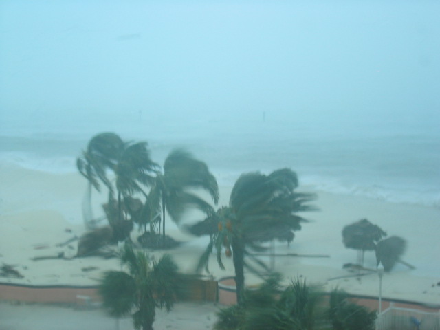
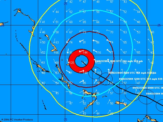
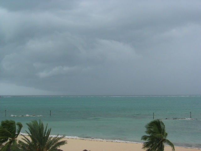

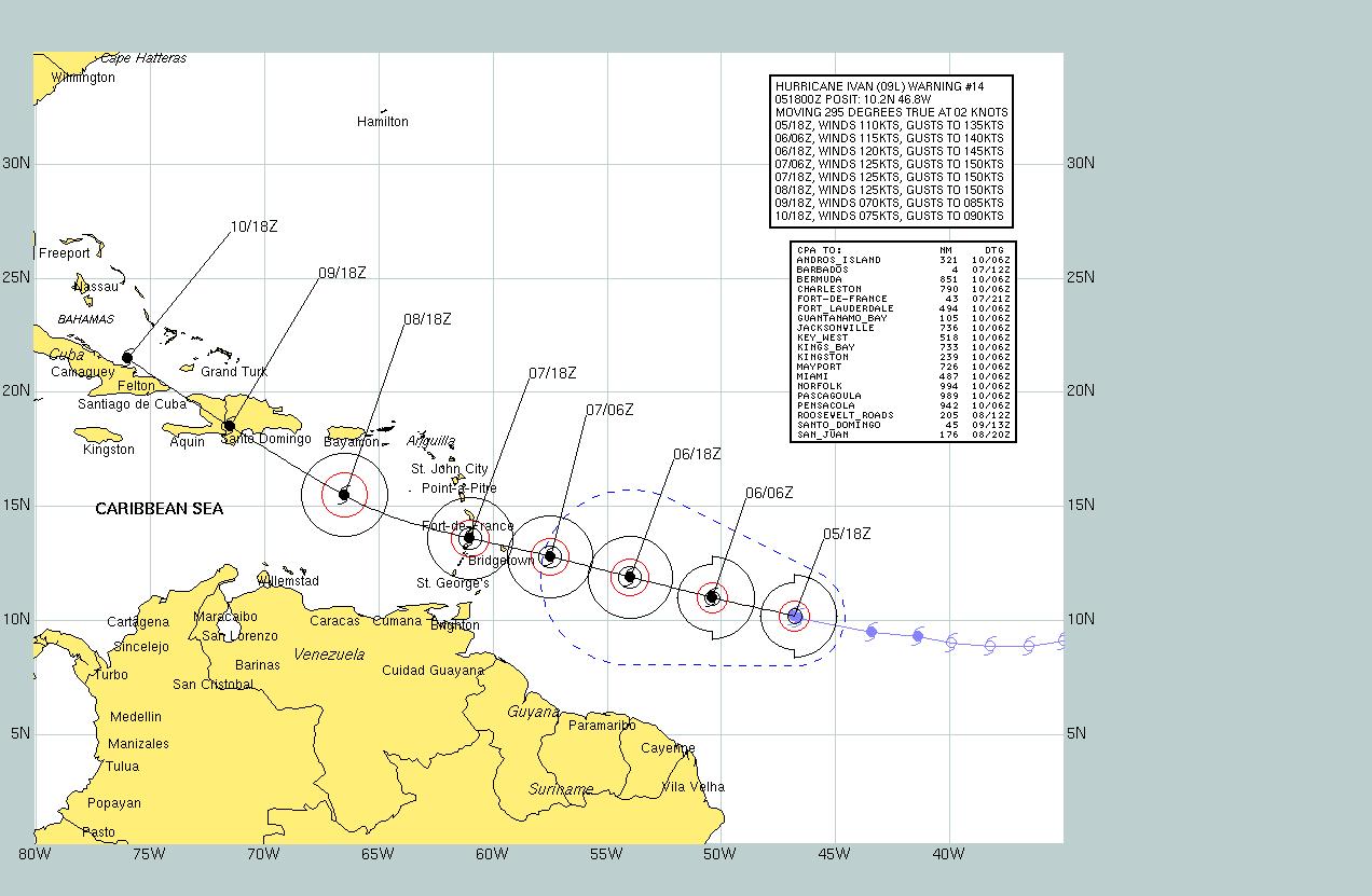
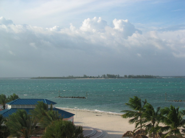
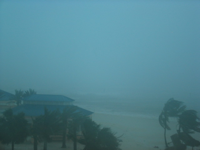
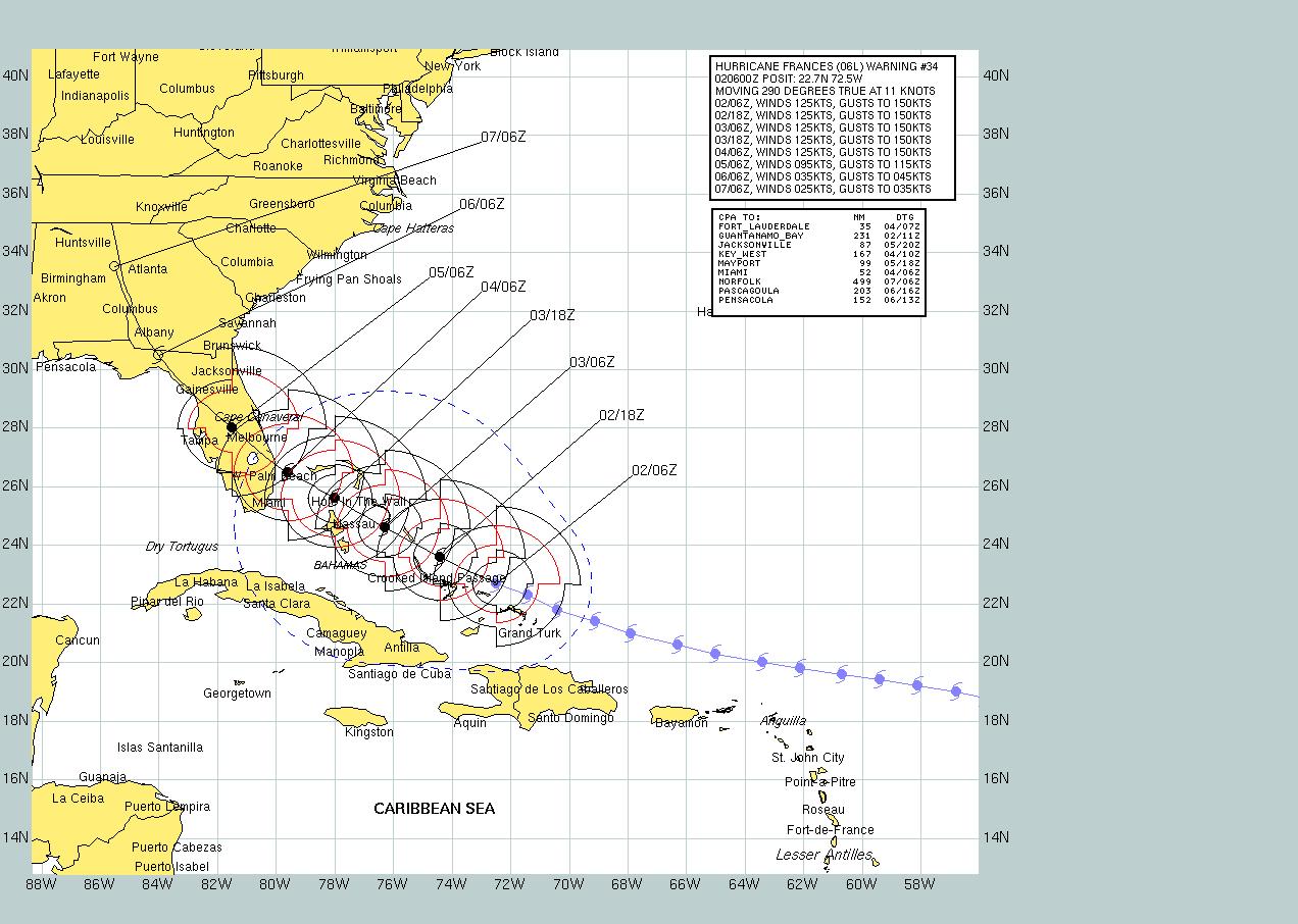
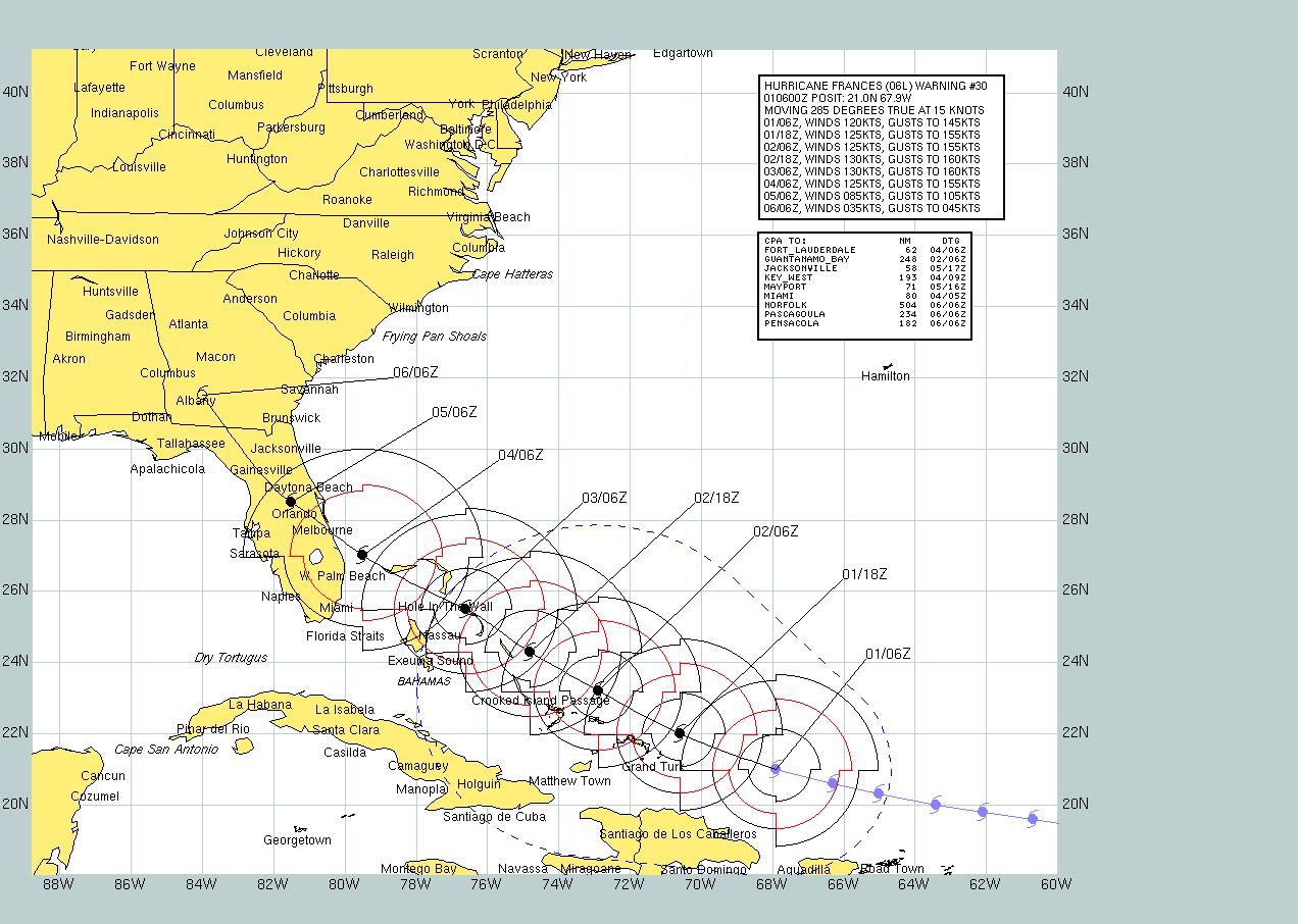
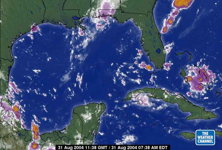
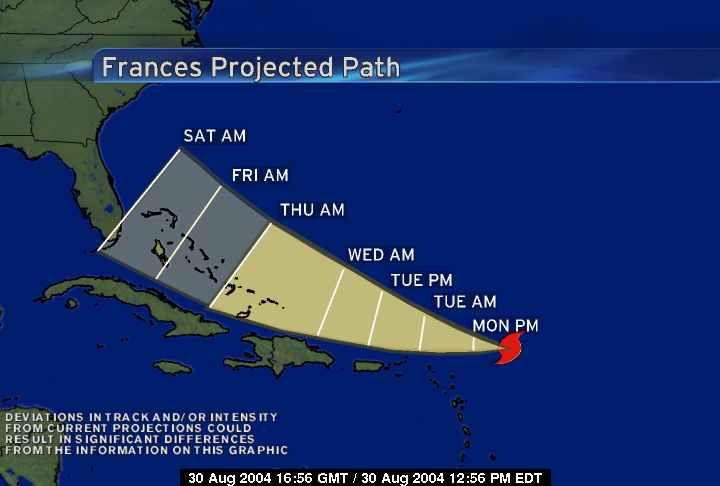
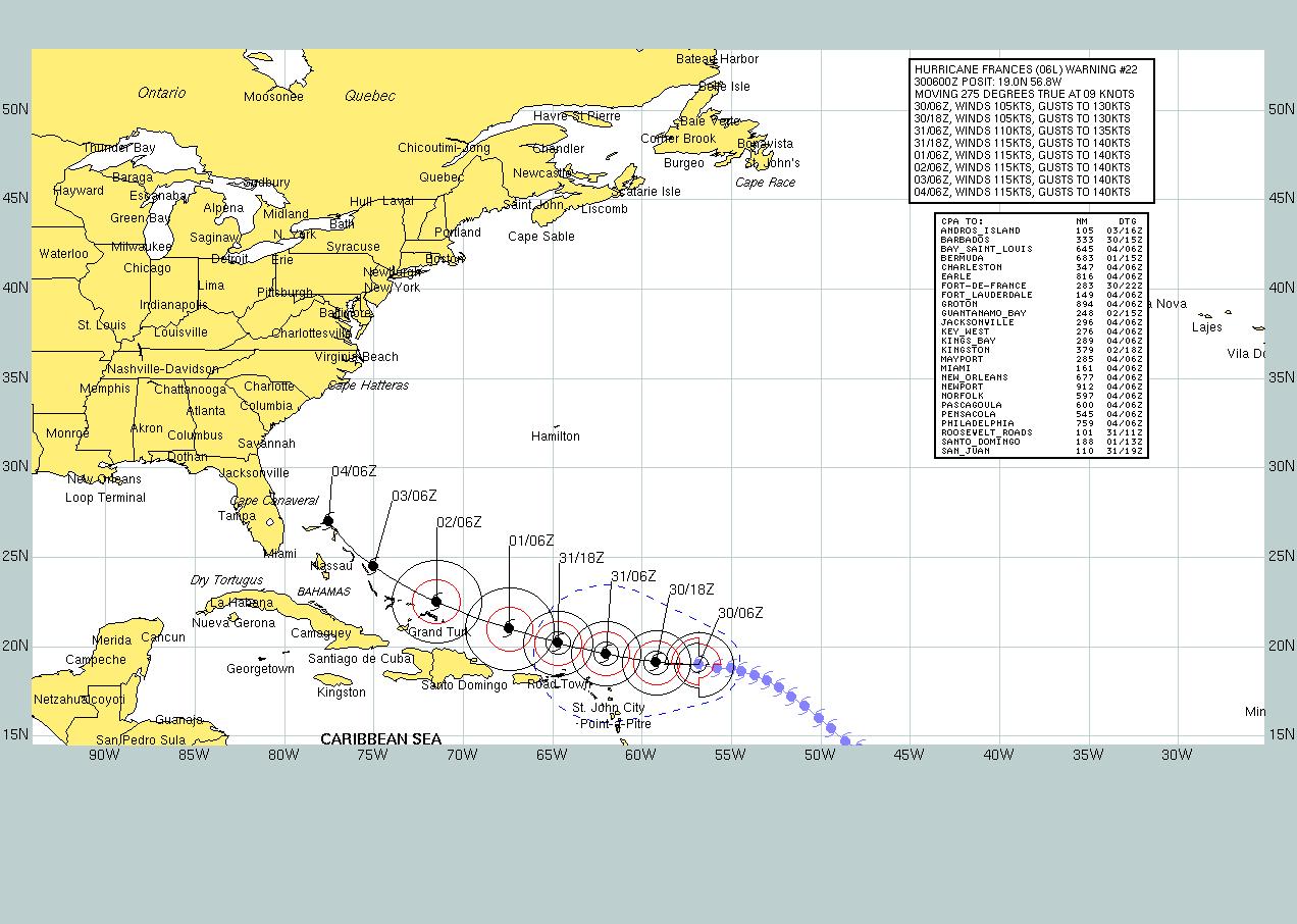