 |
Caribbean Hurricane Network
- 2 0 1 1 Season - |
|
|
|
2011 Atlantic Hurricane Season |
|
| Arlene | Bret | Cindy | Don | Emily | Franklin | Gert | Harvey | Irene | Jose | Katia | Lee | Maria | Nate | Ophelia | Philippe | Rina | Sean | |
The heart of the Caribbean Hurricane Network are the personal reports send in by the special hurricane correspondents on the islands. Find out whathappened on your favority island during the 2012 Hurricane Season by following the links below.
Following is an archive of all weather discussions Dave and I posted. They are in reverse chronological order, with the most recent storm discussion on top. If you want more background in formation on specific storms, I have found the 2011 Atlantic Hurricane Season section in the Wikipedia a great resource. Also, visit the Hurricane Research Division of NOAA's Atlantic Oceanographic and Meteorological Lab for 'best track' data of all 2011 storms. The track map below is from that website as well.
- - 2011 Hurricane Tracks - -
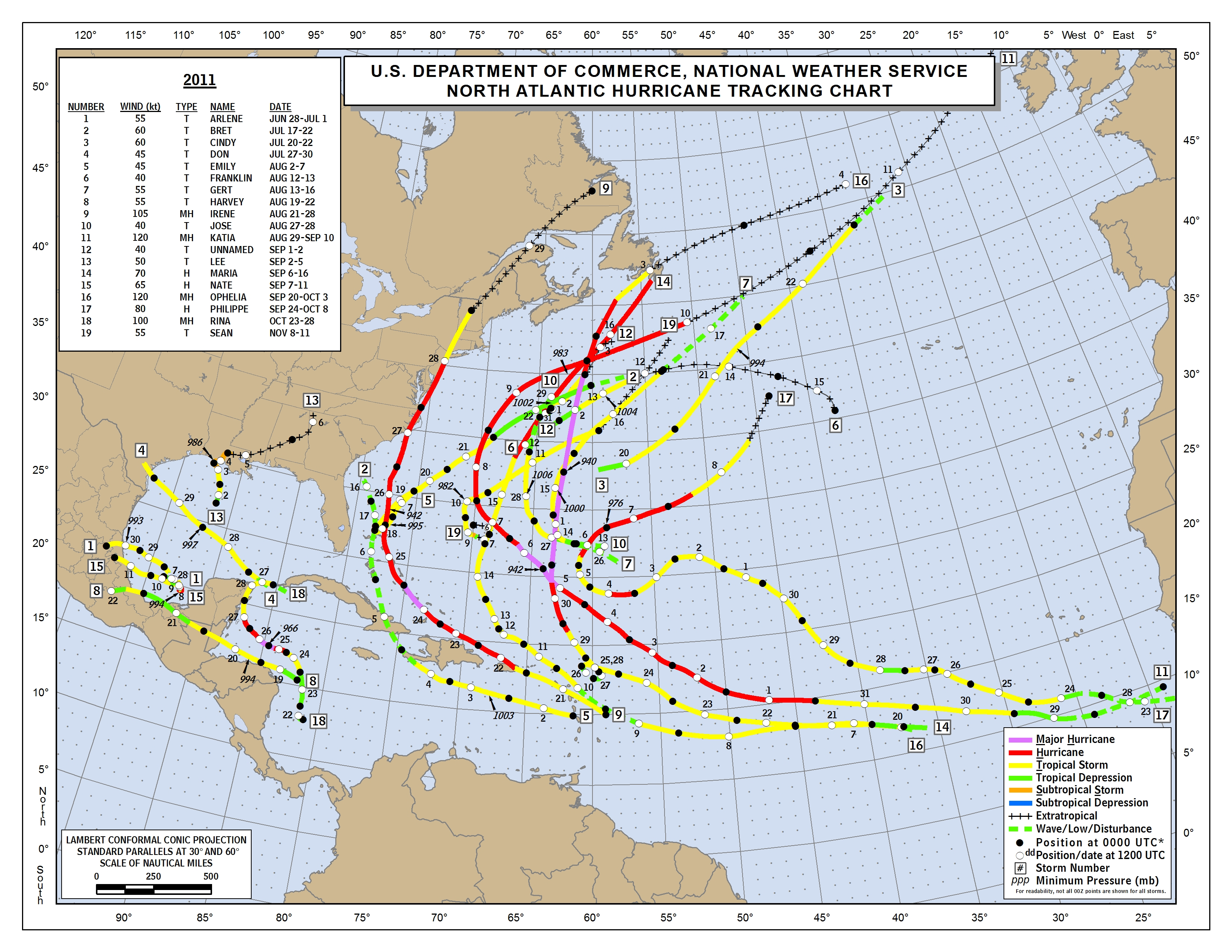
- - Source: NOAA/AOML Hurricane Research Division (click on image for larger size) - -
Weather discussions by Gert & Dave during the 2011 Atlantic Hurricane Season. The homepage with the links to local reports from the islands, latest satellite image, current weather outlook can be found here.
Thursday, December 1, 2011 08:19AM PST - Another season over
- Although we still have an Invest out there, Hurricane Season is officially over. There were a lot of tropical storms, with a total of nineteen, it tied for the third busiest season for tropical storms. But just a few of these made it to hurricane strength. Luckily for us in the Caribbean it turned out to be a pretty good season. Some notable ones for us were Emily, Irene, and Rina. And although a lot of storms seems to be attracted to Bermuda this year, they dodged the bullet each time!
A big thank you of course to all the special hurricane correspondents who again volunteered their time and effort this season on keeping us up to date on what is really happening on the islands! -Gert
Thursday, November 24, 2011 06:56AM EST
- Tammy who?
-
Good morning!!
Happy Thanksgiving to all who observe this holiday!
It's been quiet in the Atlantic as it should be while former Cat 4 hurricane Kenneth has set a record in the E. Pacific as the strongest hurricane at 145 mph this late in that areas season. No threat to land, he is dying just as fast as he rose.
However, it looks like we might have something late ourselves next week in the form of a named storm in the southern Caribbean north of Colombia as the global computer models are starting to come to a consensus. The next name is Tammy. Current long range forecast (and we all know what to think of those) has this developed system wandering aimlessly before finally making a beeline for Central America. Not good anytime and especially not good for the holidays.
As noted by Puerto Rico and having been through Georges, Omar and the infamous "Wrong Way Lenny", the possibility does exist, if developments occur as projected and a tropical system forms, it could travel our way. Not like it hasn't happened before as noted above.
Either way, a significant rainfall event is forecast with high confidence to occur over Eastern Puerto Rico, the USVI and BVI's Saturday night through Monday night. The every couple of years "around Thanksgiving deluge" may be coming together.
Dave
Thursday, November 17, 2011 15:05PM EST
- last minute system?
-
Good afternoon!
Late season tornadoes, snow in the Northwest, a weak El Nina in the Pacific and a possibility of one last tropical system spinning up both in the Atlantic and E. Pacific basins make for weather potpourri for 500 Alex!. For the E. Pacific, its a really late possibility even though the EPAC season also ends Nov. 30th.
Meanwhile, off to our east is a trough which appears to be slowly trying to form a surface low to the northwest of the islands. This trough is having a rough go as wind shear is kicking its butt so development will be slow if at all. Low level moisture continues to be "pieced" from it though as evidenced by the quickly moving scattered showers that have been prevalent most of today across the northern islands. Good thing that trough is where it is though as if it was to sit on us, major flooding would have been problematic.
Happy Thanksgiving to all who celebrate it and Seasons Greetings to all!!
Dave
Thursday, November 10, 2011 20:13PM PST - Sean closing in on Bermuda
- Sean is now a tropical storm packing winds of 65 mph. The center of Sean is expected to pass about 90 miles to the north of Bermuda tomorrow morning (see closest point of approach tool), and is therefore under a tropical storm watch. Tropical storm force winds actually extend outward of the center about 255 miles, well within reach of the Rock. For people on Bermuda, the strongest winds are on the eastern side, so once the center has passed it won't get any worse. I am confident that Bermuda can weather a storm like this very well, but still stay safe! -Gert
Tuesday, November 8, 2011 09:25AM PST - Sub-tropical storm Sean
- It's not over yet! The nineteenth named storm of the season formed between Bermuda and the Bahamas. Right now the closest point of approach for Bermuda is just 100 miles to the north on Friday morning. The current advisories show that it should still be 'just' a tropical storm by then. Sean is a 'sub-tropical storm', the main difference with a normal 'tropical storm' is that most of the high winds and heavy rain is at least 100 miles removed from the center. Once the winds and thunderstorm activity gets more 'focused' around the center it becomes a tropical storm, which is expected to happen with Sean soon. Stay safe! -Gert
Thursday, October 27, 2011 11:02AM PDT - Rina weakening but slowing down...
- Unexpectedly Rina has weakened into a tropical storm due to some wind shear. That is good news, esp. now that it is so close to the Yucatan Peninsula. However, this is kind of a mixed blessing since now its forward motion has significantly slowed down, and Rina is expected to just meander around a bit for the next couple of days. That means that locally it will rain a lot and probably will cause flash flooding. Check out the advisories and model spaghetti plots for the latest. Also look at the closest point of approach-tool and overlay the satellite image on the map. This will show that parts of the storm are already over land. See the reports from Mexico, incl. Cozumel, Playa del Carmen and Cancun for the latest updates by the special hurricane correspondents there. -Gert
Tuesday, October 25, 2011 15:51PM PDT - Almost major hurricane Rina on its way to Cozumel and Cancun
- Hurricane warnings have been issued for most of the east coast of the Yucatan Peninsula, as well as tropical storm watches for the coast of Belize and the Bay Islands (Honduras) [see more detailed info in the advisories]. Rina is now a strong Category 2 hurricane, and is expected to strengthen into a major storm!
The eye of the storm is still expected to brush by the Yucatan coast (Playa del Carmen/Cancun) or go over the island of Cozumel. The closest point of approach for Cozumel with the center of the storm is only 3.6 miles, Thursday afternoon, so people should be getting prepared now!
Meanwhile, Invest 97L might become a threat later for Jamaica or Cayman. Some models predict it to become a hurricane within four days. Stay tuned... Lots of action this late in the season. -Gert
Monday, October 24, 2011 15:06PM EDT
- Hurricane Rina
-
Good afternoon!
Well, with an official 5 weeks left in the 2011 Atlantic hurricane season, we have seen many names, 17, but not many hurricanes, only 6 with 3 making major hurricane status. Rina may make 4 before all is said and done. With just 21 hours elapsing between TD status and hurricane status, Rina has embraced the rapid development normally seen when low wind shear and very warm and heat deep waters coexist. Moving to the NW at only 4 knots, Rina is expected to brush the Yucatan Peninsula and Belize where heavy rains occurred not that long ago with the Caymans receiving cistern filling deluges in time for the Christmas drier season. Look for possible bad flooding if this storm meanders and moves slowly as forecast.
Track: Discombobulating. The 5 pm update will have all of the computer solutions programmed by then but right now, it looks to make a hard right turn and go over the Isle of Man SW of Cuba after giving the Yucatan a good blow by. In the meantime, a NW to N motion should occur. It will be interesting to see if a low pressure trough picks up Rina and takes her south of South Florida. Hostile wind shear and dry air will play a major part in Rinas intensity once picked up. For now, to me, Cuba, the Keys, extreme S Florida and the Bahamas should be paying closer attention. While not out of the ordinary or unexpected, a little farther to Central Florida might want to watch too. Last track option not likely but hey, its Mother Nature. If it doesn't get picked up, a hurricane amok in the Gulf? Wind shear would definitely have a say in that! Halloween hurricane!
97L hovering around the ABC islands north of South America has been a copious rain producer for some normally arid islands. This too has the potential to be a GOM player and needs to be paid attention too. Could be a sleeper you don't want to stay overnight.
Central Atlantic, around 48W there is another area of low pressure but it is not being paid any notice at this time!!!
The 5pm and 11pm tonight should be quite interesting!
Dave
Monday, October 24, 2011 08:00AM PDT - Tropical Storm Rina
- The seventeenth (!) named storm formed in the northwestern Caribbean, close to Honduras. It has been dumping a lot of rain in Honduras, but is now moving to the northwest. The center of Rina is forecast to stay just off the coast off the Yucatan Peninsula, but cross Cozumel in a couple of days. But since it has to make a sharp turn it is hard to forecast the exact track. Also, Rina is expected to strengthen into a hurricane. So everyone on the east coast of the Yucatan, incl. Cancun, Playa del Carmen, Tulum and also Belize to the south. Check how close it can get to you, or use the other tools above. See also the updates from Mexico and Belize.
Further to the east we have Invest 97L, in the opposite corner of the Caribbean Sea, dumping a lot of rain in the southern islands. Check out the reports on the right for what is happening there. -Gert
Monday, October 17, 2011 09:42AM EDT
- Soon
-
Good Monday morning,
A quick note tonight. First, thank you Gert and thank you to all who emailed me and confirmed the flooding in Trinidad. Wow! That was alot of water in 7 short hours!!!!!!!!!
95L is close to TD status with falling pressures and TS force wind speeds over water and a few noted over land even though the main convection is displaced from the center of circulation. As it moves north, then northeast, it will dump copious amounts of rain on some already soggy terrain in Florida and the Keys. This could turn into a powerful extratropical system as it burns its way up the east coast after the Florida crossing.
Actually, I wouldn't be surprised if it jumps to TS status right away, skipping TD status and would be named Rina.Advisories and warnings would be issued but the problem is, this system is close leaving not much time for preparation. Hopefully, most of the people with any experience and/or brains will have already secured their boats in the numerous marinas dotting the coast. Don't see storm shutter weather but other preparations should be made. Further strengthening before running over Florida ala OJ style is not expected as wind shear should increase dramatically.
1370 miles to the east of the Windward Islands, another tropical wave, a late contender, still has possibilities but wind shear will keep it dampened down for the next few days inhibiting anything substantial.
Dave
Saturday, October 15, 2011 17:00PM EDT
-
-
Good evening again!

I need to welcome two new volunteer correspondents to Storm Carib,
Jimmy and Linda Magner! Yes, I have pestered them for years to
volunteer as they have much local knowledge and finally, it paid off!
Happy to have you aboard! I'll explain those rings further when I get
back!!!

Dave
Saturday, October 15, 2011 16:55PM EDT
- Late action
-
Good evening!
Greetings from rainy, fall coud covered, 47 degree upstate New York!
While excellent sleeping weather and I get to wear my one pair of jeans, the daytime temps just don't mirror the beautiful Caribbean! I'll be back home soon!!!
95L is a rather large disorganized system off the east coast of Belize and is expected to move north through the Gulf then northeast across the Florida Peninsula bringing very heavy rainfall. Any remnants of drought will be extinguished by this system. Due to the rather large size of 95L, the chances of development are slim past the tropical depression stage and I did say slim, not never. The last several years have proven never say never rings of almost 100% truthfulness. Gusty winds and some high rough seas will accompany 95L but should not be of any significant disruption to oil production either.
845 miles SW of the Cape Verde Islands is a tropical wave trying to get in the record books as a late Cape Verde season named storm but appears to have fizzled a bit convection wise. Wind shear has weakened considerably though which could allow it to refire as the waters cool on that side of the Atlantic. Something to watch as the new week progresses.
I understand there is severe flooding in Trinidad but have not been able to confirm. T&T correspondents?
Dave
Wednesday, October 12, 2011 08:28AM PDT - Quiet
- It's mid-October, just 1½ left in official hurricane season, and nothing going on in the Atlantic. However, something might be brewing in the Western Caribbean, we'll see what happens.
On the Pacific side, Hurricane Jova made landfall as a Category 2 storm, near my beloved town of Puerto Vallarta. See Google-News for info. -Gert
Wednesday, October 5, 2011 08:11AM PDT - Philippe still going
- After 12 days Philippe is still churning the Atlantic Ocean. It might even become a hurricane again. However, it should not be a threat to land, incl. Bermuda where it should stay at a safe distance of over 400 miles. Elsewhere not much going on for us. However, hurricane season is not over yet, although the chances are getting lower to get some of those powerful Cape Verde storms. See the 'hurricane points of origin' in the climatology section for where storms form during the different months of the year.
On another note, thank you all so much for your donations! The website's future is safe again! I will probably also reshuffle some of the ads on the website to generate more revenue so that I am not as much dependent on donations. Thank you all for supporting the website and for the very nice feedback I received. -Gert
Friday, September 30, 2011 08:27AM PDT - Major Hurricane Ophelia
- Ophelia has just been upgraded to a Category 3 Hurricane and you can see her eye on satellite imagery. The islands were quite lucky that this didn't happen a bit earlier... Unfortunately, Bermuda is again (!) on a tropical storm watch. Right now the closest point of approach for Bermuda is about 150 miles to the east (Saturday night). This is a bit more east than yesterday. Hope this trend continues. However at that time Ophelia is still expected to be a Category 2 hurricane with 100mph sustained winds. So we have to keep watching... I'll move the projection of the satellite image in a bit to show Ophelia in relation to Bermuda. Stay safe! -Gert
Thursday, September 29, 2011 15:21PM PDT - Hurricane Ophelia
- And another Ophelia surprise, it became the fourth hurricane of the season. It is actually unusually low that only 4 out of the seventeen storms so far have become hurricanes. But we are not complaining about that! Ophelia is also moving away from the islands, now over 200 miles north of Anguilla. This very slow moving storm never actually really reached the islands. However, it might get close to Bermuda (again). Right now the closest point of approach is only 130 miles (Saturday evening). Stay safe. -Gert
Tuesday, September 27, 2011 15:27PM EDT
- Another Phoenix!
-
Good afternoon,
The remnants of what was TS Ophelia has loitered around long enough to regenerate considerably and will probably be reclassified a TD shortly. The NHC might be a bit reluctant to jump on that bandwagon though due to the fallout from Maria but it is what it is. The COC and lower pressures are farther south than previously thought as hurricane hunter aircraft are spending considerable time mapping out this phoenix-like tropical feature. With that said, TS warnings would be issued for the northern Leewards with short notice. Squally rains and winds are expected unless she moves more north than west.
More as information becomes available and analyzed.
Dave
Tuesday, September 27, 2011 09:47AM PDT - Big Blob
- What was once Ophelia is now a big blob on satellite images closing in on the northern Leeward Islands. It was supposed to have passed Sunday, but it is still there! This slow moving system will therefore cause a lot of rainfall on the islands. That is not all, the National Hurricane Center is giving this system an 80% chance that it will become a depression again! So with the rain, it might get a bit windy too! Stay safe... -Gert
Sunday, September 25, 2011 20:16PM PDT - Bye bye Ophelia
- Ophelia has been downgraded to 'post-tropical cyclone' Ophelia, meaning that it is weakened into a tropical wave. However, it is still a big 'blob' on satellite images, and it will skirt by the northeastern Leeward Islands, like Antigua, St.Maarten, Anguilla, with some squally weather. But nothing like a big hurricane or anything.
Then we have Philippe still far out their in the Atlantic. It is still expected to curve well north before it ever reaches the islands. So we don't have to worry about this one anymore. -Gert
Saturday, September 24, 2011 11:05AM PDT - Ophelia and Number Seventeen
- Ophelia is doing what it is supposed to do, though taking her time. As it looks right now it should still pass nicely north of the islands and probably even passing Bermuda on the east side. The closest point of approach is still a day away. Also, remember, it has a powerful tail end... Use the tools above to check out the threat to you. Also, try the My Satellite feature to view satellite loops centered on where you live.
The tropical wave far out in the Atlantic that Dave mentioned yesterday has been upgraded to Tropical Depression Seventeen. It is expected to become Tropical Storm Philippe within a day. The good news is that it is expected to curve north well before it reaches the islands. Stay safe! -Gert
Friday, September 23, 2011 11:08AM EDT
- hunk of burning satellite
-
Good morning again,
Please take a look at the post from Chris in Grenada at 10:31 am this morning regarding the imminent return of a satellite to earth. If you are in the northeastern islands, you might want to look up late this afternoon around 6 pm! Thanks Chris!!
Dave
Friday, September 23, 2011 10:37AM EDT
- No slow down
-
Good morning and Happy Friday!
TS Ophelia is having a rough go trying to survive the trek across the Atlantic doing battle every step of the way with wind shear her primary nemesis as it has been for most of the systems so far this tropical season. Forecast to weaken even further to TD status and possibly revert to an open wave, she nevertheless marches on heading WNW. Her track has some variables in it though. If she maintains strength somehow, she should still maintain the WNW track and stay about 265 miles to the north of the Virgin Islands. If she weakens to a TD or even an open wave, she will stay on a more westerly track. hurricane Hunters will be investigating her today and we'll have some more accurate projections.
Regardless or irregardless, Ophelia should not be the main culprit in the rains we can expect Sunday night into the work week as her main activity is to the north of the COC (center of circulation) and our islands would be on the drier, less active southern side. What she does have, which has been typical of our visiting systems this season, is a tail which is tied to the ITCZ. As she passes to the north, she will be pulling this deep tropical moisture behind her and we could be in for another bout of squally, heavy rain and possible flooding as our grounds are still on the saturated side. Bernie Raymo, an Accuweather Meteorologist for TV2 as Isabel of St. Croix mentioned, pointed this out last night. For a change, I think he might be right.
Off to the east, we should have our next Invest designation by 11am or the latest 5 pm today as a new entrant to the fray has decided to do a bit of bristling of its own. Just off the coast of Africa, current thinking is this wave will develop into at least a tropical storm and trek west, then WNW just like the rest of them so far. Time will tell. this looks to be another weekend visitor.
Off the coast of Florida there is an area of possibility and the artist formerly known as 99L continues on its merry way south of Haiti with another blob off the coast of Central America. The eastern Pacific has hurricane Hillary which probably should be upgraded to cat 5 shortly.
Residents along the gulfcoast should be paying closer attention to the SW Caribbean and the GOM as I mentioned previously concerning the potential for activity in October.
Have a great weekend everyone!!
Dave
Thursday, September 22, 2011 20:35PM PDT - Ophelia continues its struggles
- Looking at the satellite image above and reading the advisories it looks like Ophelia has had her best days. The wind shear is taking its toll on the storm. That's the first good news. The other positive development is that Ophelia is going even more north. Right now my closest point of approach tool shows that it will stay over 200 miles to the north of Antigua and Anguilla. However, there seems to be a little tail behind Ophelia's center, so don't be surprised if you get the worst weather after the center has actually passed. Stay safe everyone! -Gert
Wednesday, September 21, 2011 21:04PM PDT - Ophelia still struggling
- Not much has luckily changed since yesterday. Ophelia is still affected by wind shear, preventing further strengthening. Some models even predict the Ophelia might weaken rather then strengthen. Also, its (her) path takes it 150 miles or so north or the Leeward Islands. All in all looking good so far. Hope it stays that way. Use the tools above to calculate your closest point of approach, or check if you are in the cone of the uncertainty, view model spaghetti plots and more... Stay safe. -Gert
Tuesday, September 20, 2011 20:45PM PDT - Tropical Storm Ophelia
- And just tonight, the tropical wave we were following has been upgraded to tropical storm Ophelia. It is still struggling with some wind shear so any strengthening is expected to be slow. That is good news. As it looks right now it is expected to pass just north of Antigua late Saturday/early Sunday, as a relatively weak tropical storm. Hope these forecasts pan out, however, like the weather :-) things can change... Use the tools above to calculate your closest point of approach, see if you are in the cone of the uncertainty, model spaghetti plots and more... -Gert
Monday, September 19, 2011 23:11PM EDT
- weekends for real!
-
Good evening,
Contrary to popular opinion I have not yet went into hibernation; I was actually into a romantic and intellectual mode. I know, scary, but, it is what it is!
99L: Looks like an old Disney favorite movie of mine called "Charlie the Lonesome Cougar"! Seems to be looking for love in all the wrong places. On the forlorn side, 99L is pretty pitiful but cannot be discounted just yet as big things do come in small packages.
98L: Speaking of big things. This one is interesting. Should be named Ophelia by the time it makes a tourist stop somewhere amid the Windward Islands and possibly PR and the Virgins. Somehow, I don't think the $1600 duty free goods rule is gonna appeal to her. Current trains of thought, and this means most of them, have a weak TS Ophelia entering the Windwards through Barbados and then curve up into the Northern Antilles which is very Marilynesque. Only an Invest right now, 98L should become a TD extremely soon if it isn't one already. I have to admit, I am not happy with this system. It will face the same conditions every other one has had as in stable air, dry air, some Saharan Dust, and our best friend, wind shear. However, we've seen a few who threw caution to the winds (no pun intended) and have kicked butt regardless of the air around them. I think this one might have that attitude.
To the coast of Africa, another pretender to the throne is ready to emerge from the royal wings as are a few bretheren behind it. "Tis the season with a mere 9 weeks to go officially so expect more suitors to line up as we continue a very active 2011 season. The GOM is quiet for now but mid October could be very interesting.
Locally, thunderstorms have erupted due to an ULL (Upper Level Low) north of PR pulling deep tropical moisture north and west. Great lightning shows have abounded for the last two hours with heavy rain with a bit more to come as I cannot see St. John right now and it's a mere 4 miles across Pillsbury Sound. (Unless they were WAPA-ized). Meaning our electrical provider has chocohontased again. The towel brigade was briefly told to stand down but has been called back up as the rains from the last few days have really tried their defenses.They have done well against this seasons adversity so far except for Irene which was a breakdown in the chain of command for which I take full responsibility.
While I try to make my posts light-hearted and entertaining, I strive to give honest and updated information to help you make informative decisions and also understand. I am very serious about the weather and what Mother Nature can and has done. She is not to be taken lightly. As we say in the Caribbean, R-E-S-P-E-C-T!
Dave
Monday, September 19, 2011 14:10PM PDT - New depression soon?
- It has been relatively quiet in the last week. Very nice to have at the peak of hurricane season! But it looks like there is a new tropical depression forming in the far Atlantic. An area of disturbed weather, designated Invest 98L, about 1400 miles to our east, has been given a 60% chance that it will become our next tropical depression, number 16 (or Ophelia if it becomes a tropical storm). It will take a couple of days to reach, but even then the models indicate that it will be barely a tropical storm. Not much to worry about as of yet, but things can change quickly so we'll keep tracking it. -Gert
Saturday, September 10, 2011 09:11AM EDT
- What next?
-
Good morning,
Just a few thoughts.
TS Maria, if you can really call her that, is taking her good old time getting to where she is supposed to be. She seems to be trying to reinvent herself before she arrives with what appears to be two separate CONC's (center of non circulation). As I mentioned early this morning, Maria is one ugly TS and right now, probably isn't even nothing but a menacing open wave. Also, her current track has shifted to the right putting the BVIs and further east islands in a worse position. It must be noted the BVIs are really not that far away from the USVI. This track however, will keep PR out of the TS force wind field. But as we all know, this can change rapidly so stay tuned and we will know more later today.
TS Nate still needs his meds while Hurricane Katia refuses to die and might even strengthen into a serious North Atlantic feature. The UK could be in for quite a wallop!
Today marks the "official" peak of hurricane season but peak means halfway. The next half should feature a few more systems coming from the east but the GOM I believe will be a hotbed soon. I understand 10 people are missing from an oil rig evac as a precaution for TS Nate. Prayers are with their families they are found safe.
Dave
Saturday, September 10, 2011 00:45AM EDT
- Ugly stepchild
-
Good morning,
I must admit, there are two of the ugliest tropical storms active right now I have ever seen and one wicked stepmother who has decided to use her evil powers elsewhere in the northern hemisphere.
TS Nate. Looks like he needs that little blue pill or some Enzite right now as his convection is a little dismal at this point for a tropical storm. Dry air from the north which has been endemic to Texas so far mainly due to La Nina has been the main culprit in Nates lack of activity except for the NE quadrant. However, Nate is forecast to rise to the challenge and become at least a Cat 1 before lumbering into the Mexican coastline causing severe flooding and possible loss of life. Extreme southern Texas might get a whiff of rain but it will only be a tease unless Nate changes his mind.
TS Maria. Definitely, not the take a letter kind. Currently, she is a lightening rod east of the Windward Islands satellite pic-wise stretching the entire length of the Windward Island chain and even has a tail already poised just above Venezuela and adjacent islands. Not your typical, rotating, pinwheel, cotton candy outflow looking TS. Maria could well not be a TS right now but for broad cyclonic circulation found by the hurricane hunters earlier. Still potent though after being written off by many experts on and off TV and radio. You never say, "it's gonna be nothing" until its past you.
TS Maria has a date with the VI just like Irene did previously and it looks like we will have to dance, even if we don't want to. Actually, it looks like she will try many suitors and toss them aside. If Maria maintains TS strength overnight and she should, it will be a rough go tomorrow afternoon through Sunday morning. 4-8 inches of rain are expected on already saturated ground with 60 mph sustained winds. A curfew is in effect from 7 pm Saturday night until 5 am Sunday morning, courtesy of the Governor of the VI. Many are taking Maria as a joke. As Gert said below, not a wise idea. Maria's future path and intensity will be very interesting to Fla after the next three days.
Hurricane Katia. Threatened many but kept to herself in the Caribbean, near Bermuda, and the East Coast. Soon to be a very powerful force in the North Atlantic and headed for a date with the UK Monday into Tuesday. Katia will be an unlucky event for many there.
Off to the east, a lurker is poised to enter the fray off the African coast as the historical midterm of hurricane season is near. Yes, I did say midterm. We have another half to go!
Dave
Friday, September 9, 2011 11:32AM PDT - Do not underestimate Maria
- Just a quick note, just because Maria seems barely a tropical storm, don't underestimate it! It is a big storm, with tropical storm winds expanding outward up to 175 miles, with the northern side being the strongest. Also, Maria has slowed down somewhat, making it more susceptible for strengthening. If you are under a tropical storm warning, better take it serious! Use the closest point of approach tool and use the latest satellite overlay option to see its size and how it can affect you! Read more by Dave below. Stay safe. -Gert
Friday, September 9, 2011 07:41AM EDT
- Here we go again!
-
Good morning,
Flight back to St. Thomas is St. Thomas is today and even though there are tropical storm warnings in effect, we should be able to get in; just in time to activate the towel brigade again, fire up the cistern pump, and revive the generator for the anticipated WAPA outages. Hopefully, this lineup can keep up this time as Irene overwhelmed the towel brigade and pump just a short while ago.
TS Maria is actually following her expected track and the models have had a decent handle on this all along but her intensity forecast, just like every other system this year, has been an enigma. Raggedy but gaining strength, I see an eerily similar Marilyn-esque path as does Ronnie of St. Thomas. I also see her strengthening quicker than forecast. Just how much remains to be seen. Right now, overnight Saturday night will be challenging. Why do we always have the night storms??
Down the road, Maria could become a Cat 2 storm headed, like Irene, through the T&C, Bahamas, and eventually threatening the east coast. She is expected to recurve like Katia missing both the mainland and Bermuda. Not sure this will happen with too many variables 5 days out. She could plow straight forward into Georgia/SC or curve into Florida. Speaking of Katia, she will be a potent force in the British Isles Monday into Tuesday.
Soon to be hurricane Nate is expected to plow into Mexico where severe flooding will cause major havoc; much like the remnants of Lee have flooded my home area of upstate NY, only way worse due to the mountainous terrain. Sadly, Nate will not give Texas any help in their drought fight. Nate does however wake a few more people up in the gulf. And don't count Nate out just yet as far as moving north instead of into Mexico. A stationary system has no destination. As I mentioned before, the GOM should be on full alert from now on.
More after I get back home.
Dave
Thursday, September 8, 2011 20:23PM PDT - Maria hanging in there...
- Not much has changed with Maria since this morning. Rather then becoming more disorganized it might actually look a bit better now... So it doesn't look like Maria will fall apart before it reaches the islands late tomorrow. Yes, that quick. Note that tropical storm winds extend outward to up to 175 miles from the center, with the northeastern part of the storm being the strongest!
Its track is similar to this morning. After crossing the islands (close to Martinique and Dominica), Maria is expected to move close to St.Croix and onto Puerto Rico. Use the closest point of approach tool to see how close it can get to you. But keep in mind the size of the storm, this storm is not just a point, following a line! With the closest point tool you can toggle the latest satellite image on top of the map so you can see its size.
Note that I made a little improvement (I hope) to the closest point tool. Now it will say when the storm will have it closest approach relative to the current time, rather then the time the advisory was issued. This sounds like a easy fix to make, but it was actually harder then I expected because of all these different time zones! If it seems amiss, let me know. Stay safe! -Gert
Thursday, September 8, 2011 08:16AM PDT - Tropical Wave Maria?
- Looks like Maria is falling apart! The latest advisories show a very different picture of Maria. It probably has no closed circulation anymore, so by definition not really a tropical storm. Although seawater temperatures are high, the wind shear is taking its toll on Maria, and its high forward speed of over 20mph doesn't help either.
Also the forecasted track is a lot more southward than before. Yesterday it looked like the center of Maria was moving over Antigua/Anguilla/St.Martin, now it looks like it might cross the island chain all the way down near Martinique. Tropical storm watches have been posted for most of the island (see the advisories.
After crossing the island chain Maria will move more northward, towards the US and British Virgin Islands and Puerto Rico where it will be Saturday/Sunday. Although Maria is now barely a tropical storm, by the end of the forecast period it is expected to be close to a hurricane. I wouldn't be surprised if it totally falls apart and passes the islands as 'just' a tropical wave, though still with strong winds. On the other hand, I wouldn't be surprised either if Maria gets its act together in a day or so and becomes a hurricane. Hard to predict these kind of storms... Use the tools above to see how close it is, model spaghetti plots, satellite images and more. -Gert
Wednesday, September 7, 2011 08:25AM PDT - Tropical Storm Maria and Hurricane Katia
- Tropical depression Fourteen has been upgraded to Tropical Storm Maria. It is moving pretty fast westward and is projected to reach the islands within 3 days. As of now, the center of Maria is expected to just pass north of Antigua, and close or over St.Maarten/St.Martin and Anguilla. Click on the closest point tool above to check how close and when the storm can get to you. The good thing is that conditions are not that favorable for strengthening, so as it looks right now Maria is not expected to be a hurricane by the time it reaches the islands. However, as we have seen before, things can change, so stay focused.
And let's not forget about Hurricane Katia. Not much has changed, so it is still expected to pass safely to the west of Bermuda, although they are experiencing the outer bands right now, plus some impressive swell. -Gert
Tuesday, September 6, 2011 23:46PM EDT
- Active and menacing!
-
Good evening,
I am still traveling so once again, this will be limited.
Interests in the GOM should be very wary until the end of the hurricane season. While the first half had major protection, the second half will not. Complacency should not be a word in your vocabulary at this time. Invest 96L might be a sleeper. Even if it is not, the GOM should be a hotbed through November.
Hurricane Katia, the up and down, long lived tropical system seemingly immortal, should miss both Bermuda and the mainland US but will leave more seaside damage through more beach erosion and rip currents which will be added to Irene's legacy.
TD#14, very soon to be TS Maria, will pose another Irene like threat to the Northern Leeward Islands although models vary with her going north of the islands or just north of Guadeloupe. While the models do not have the future Maria attaining minimal hurricane status beforehand, it is very possible. I should be arriving back in the USVI on Friday, just in time!
The wave south and behind TD#14 is a lurker which might be a powerful contender down the road. Looks like it wants to be a sleeper.
Be safe and stay vigilant. The peak of the 2011 hurricane season is almost here but then, there's more......
Dave
Tuesday, September 6, 2011 13:42PM PDT - Number Fourteen
- A quick update, Invest 95L was just upgraded to Tropical Depression Fourteen. The forecast shows that it will be near the islands in about 4 days, Saturday, at that time it is expected to be a strong tropical storm (Maria), but no hurricane. Use the tools above to check how close it can get to you and more. -Gert
Tuesday, September 6, 2011 08:23AM PDT - Tropical Storm Ahead?
- Katia is now a Category 3 hurricane, earlier it was even a Category 4 storm. Things still look ok for Bermuda. The center of the storm should stay a safe distance from 'the rock', but they will be affected a bit by the outer bands and high surf.
Our invest in the Atlantic, 95L, is still just an invest. The National Hurricane Center gives it a 70% chance to become a depression. Its path could take it through the Islands, although a path similar to Katia or a bit more south seems more likely at this time (see the model track links above). The model intensity forecasts indicate that it might be a tropical storm (Maria) by the time it reaches the islands in 3-4 days... -Gert
Monday, September 5, 2011 11:29AM PDT - Katia's eye
- Katia is now a Category 2 hurricane, and is expected to become a major hurricane later today. A large eye is visible now on the satellite image above, which I moved a bit to show Katia relative to Bermuda. Although the center of Katia is expected to pass about 300 miles to the west of Bermuda, the island will still feel its effects of Katia's outer bands and high surf.
Far out in the Atlantic is a new invest, a strong tropical wave, which the Hurricane Center gives a 60% chance of become a tropical depression. The next name on the list is Maria. Looking at the spaghetti plots (see model track links abov) it looks that it might either pass through or move just to the north of leeward islands by Saturday or so. It's intensity forecast doesn't make it a hurricane in the next 5 days though. Stay tuned... -Gert
Saturday, September 3, 2011 10:49AM PDT - Super Soaker Lee
- Things are looking good regarding Katia at the moment. It has not become as strong as forecasted and it is passing by the islands, although they probably will experience some high swells. Also, it looks that Katia will move west of Bermuda, but it is still a bit too early to let our guard down.
Lee on the other hand has more or less stalled off the coast of Louisiana, continuously dumping heavy rains in that area. As we see again, not the winds, but the rain that comes with tropical storms or hurricanes are causing the most trouble. -Gert
Friday, September 2, 2011 10:09AM EDT
- limited
-
Good morning,
Been traveling and service has been spotty up here in the mountains of Tennessee hence, the limited posts and shortness of this post.
TS Katia regained hurricane status and is expected to pass well north of the islands. Not liking the possible west track after 5 days though as a probable Cat 3.
TD#13, likely TS Lee, probably won't help Texas that much but this slow mover is likely to produce flooding rains over other drought parched areas. I did mention last Sunday the GOM was gonna start heating up!
Meanwhile, 94L will stay swimming with the fishes.
More as signal strength and time allows.
Dave
Wednesday, August 31, 2011 14:24PM PDT - Almost Hurricane Katia
- Not much has changed with the latest advisories. Katia is now a borderline hurricane with 70mph winds, and is still forecast to be a major hurricane in 4 days. Also, it still moving west-northwest, currently at around 14.6N, 42.6W. It has climbed almost 2 degrees latitude over the last 24 hours. I'd like it to be above 18N well before it reaches the islands so it can pass north of it, and it looks like that will indeed happen. Using my Closest Point of Approach (CPA) calculator the center is forecast to move about 380 miles to the northeast of the Leeward islands, a safe distance. Hopefully it stays that way. On the other hand, Bermuda should start taking close attention to the storm. The model spaghetti plots are moving the storm pretty close to Bermuda, although it is still too early to tell for sure of course.
There is also a new invest close to the Yucatan and moving into the Gulf of Mexico. That one should not pose a threat to the islands if it develops into something. -Gert
Tuesday, August 30, 2011 09:25AM PDT - Katia is coming...
- As expected tropical depression Twelve was upgraded to tropical storm Katia. As it looks right now, the center of Katia is still expected to pass about 300 miles to the north of the Leeward Islands. However, since Katia is forecast to be a major hurricane in five days and since it is still about 2000 miles or about 5 days away, it is way too early to relax. Use the tools above to track the progress of the storm, by checking when and how close it can get to you, see if you are in the cone of uncertainty and more.... -Gert
Monday, August 29, 2011 09:34AM PDT - Jose and Number Twelve
- While everyone was focusing on Irene, we had tropical storm Jose pass by Bermuda. Luckily other then some squally weather no problems, according to the special hurricane correspondents on Bermuda. It dissipated earlier this morning.
However, as Dave mentioned yesterday, there is a new 'Cape Verde' storm, at this moment still a tropical depression, but probably later today tropical storm Katia (a new cyclone name that replaced Katrina). As of now it is expected to move a pretty safe distance to the north of the Leeward Islands. But it is still way too early to tell since it is more then 6 days away. But if it does make the turn more north, Bermuda should again be on the lookout. -Gert
Sunday, August 28, 2011 10:16AM EDT
- Next!
-
Good Sunday morning,
Still Hurricane Irene is making another landfall, this time right over NYC. Having weakened to a minimal Cat 1 with a probability of a downgrade to TS status at the 11 am advisory, Irene is still a potent force although even with the over-hype. That being said, I'd rather have said the sky is falling and it didn't then not say it and it did. Hope for the best, prepare for the worst.
Two sad things come out of Irene that stand out: First, I said in a previous post, people will die in this storm. So far I believe the toll is at 9. It should only be about 4. Those were of the unpreventable, unforeseen variety such as that poor kid who was on the second floor of his house when the tree fell on it and him. Most were of the preventable variety like the person who was driving during the height of the storm when a tree fell on his car. Didn't they say, stay indoors??? In Florida, two people died when they decided "surfs up" and went into an angry ocean. DUH!!!! More trees or limbs caused several other deaths where the people should have remained inside. I myself was stupid during a storm once, during Hurricane Marilyn when I went out at the height of it at 1:30 am to replace a broken window. I saved my apartment but in retrospect, I was lucky. Very lucky.
Second standout: Cynicism is sure to take hold as Irene didn't quite provide the doom and gloom expected. The next time a storm with Irene potential roars towards NYC and New England, apathy will hold sway. That little storm? Were not going anywhere! Irene didn't do much, why do I have to evacuate? This will only lead to many more preventable deaths and chaos.
Enough of Irene.
The little system south of Bermuda that is still poised to ride Irenes coattails has now been designated TS Jose. Frankly, TD#10 was a much better looking best man. Still, the ugly stepchild of Irene, growing from virtually nothing early this morning, is moving north towards Bermuda and a TS warning has been issued. This will probably be like a super cell storm to them though as they are veterans of tropical systems, their building codes for storms are some of the best in the world, and their people listen!!!
92L. SSW of the Cape Verde Islands, I actually expected this to be designated Jose in a few days. This feature could have evil intentions down the road as most models, which really do not do well with weak, non-named systems, have it tracking NW of the Northern Leewards and up through the T&C and the Bahamas. That is not my definition of fish! However, it's way too early to tell at this juncture.
The African coastline continues in "projectile blobbette" mode as the "lemmings of weather" (tropical waves) continue their inexorable march across the continent to the sea. We still have 94 days left in the Atlantic official hurricane season with the historically most active part yet to come.
A side note for those of you in the GOM: with the degradation of the Texas ridge, which has had a draconian grip over much of the SW, tropical systems will now find it a more hospitable area for development. Look for development in the Bay of Campeche and the Western Caribbean although it is too early in the Cape Verde season to count them out. 92L, if it remains low, is a long distance possibility.
Dave
Saturday, August 27, 2011 08:53AM EDT
- Rest of the Atlantic
-
Good morning,
Prayers and thoughts to all along the NE corridor. NJ and NY, particularly NYC and Long Island, you are in for one nasty suprise.
That blobbette which was to the Windward Islands east is now south of Puerto Rico and is quite impressive in size and convection. Nothing has been breathed about this blobbette from the NHC as all eyes are on Irene. Might be interesting once it reaches 70-75W. A breakdown of that pesky Texas ridge next week is forecast finally and this would take away its "Travelers" umbrella of protection it has enjoyed all season thus far. This also brings the GOM into play for the rest of the season.
TD#10, which I believe to have reached minimal TS status but was never designated TS Jose, (I think the NHC didn't want to spread itself too thin) is now rapidly losing its window of opportunity. A "fish storm" designation from the start, nevertheless, it is in the history books as a TD for this very active season.
91L has virtually no chance south of Bermuda to make it to even TD status and appears to be hanging around to ride Irene's coattails to the North Atlantic and beyond.
Down the road, long term models forecast several developing waves coming off the coast of Africa. One should be a TD within a few days. At this time, both would appear to become fish storms themselves but it is WAY to early to put any confidence in any track right now. Saharan Dust is at its lowest level since the season started and it usually disappears around Sept. anyway so anything that makes it west has a better chance to ramp up quickly. I don't think we will see many Invests maintaining just Invest status for week periods at a time like 97L and 98L anymore.
It's calm today around the Virgin Islands with flat seas, no wind, and a hungry new clan of mosquitos hatched from Irene's rains last week on the prowl. Is this just a lull in the action? Probably.
Dave
Thursday, August 25, 2011 08:47AM EDT
- Historical & Irrepressible Irene
-
Good morning,
Hurricane Irene, currently undergoing an eyewall replacement cycle, is plowing through the NW Bahamas retaining Cat 3 status although, due to the fact it is undergoing it's eyewall replacement cycle, I believe it's really lower as a strong Cat 2. So much for semantics. Currently, according to the very latest recon mission, not official forecast, there are two identifiable eyewalls. The inner is 20 miles in diameter while the outer is 40 miles in diameter. Once the inner wall is absorbed and the outer wall takes control and starts to contract, strengthening will re-occur and probably of the rapid intensity variety. This should start to take place later today. Will it be enough to still reach Cat 4 status? Probably for a short while.
Located approx 55 miles ENE of Nassau according to recon or 65 miles if you subscribe to the official 8 am forecast, irrepressible Irene continues to retain low pressure of 951 mb and is moving NW at 13 mph although recon noted a more NNW component and several slight jogs to the west are noted on satellite imagery. The farther west Irene reaches before making an official North then NNE turn, the worse it will be for all concerned up the east coast. Outer rain bands have already made the Florida coastline with more on the way. Currently not feeling tropical storm force winds but they might if the turn doesn't occur soon. And, dare I say it? It is still possible a turn might occur very late surprising the mid and upper Florida peninsula and Georgia with little to no time for evacuations or preparations although those should have already been done anyway. It wouldn't be the first storm to not turn. There, I said it!
Please check out the excellent reports from our correspondents on the right side of your screen. These first hand accounts by those who are living the Ireneacost plus others who are monitoring and reporting are very important to our understanding of these storms not to mention honest and factual accounting of just what is going on at that moment where they are which is something TWC cannot or will not do. I don't see Mike Seidel in the Bahama's.
History is what it is: history. Irene, if she follows script and actually, even if she doesn't, will be making history the next 5 days and it's not going to be an event remembered fondly. People will die in this storm. People will not leave under mandatory evacuation orders then need to be rescued. If they do get rescued, I say the state should make them pay for that rescue as they shouldn't have been there in the first place. If your reading this all along the east, heed the warning and leave when asked. After all, it's not just your life you don't seem to care about, it's you don't care about those who put their lives in jeopardy to save yours. Selfish? Yes, deadly selfish.
While the world watches Irene, we in the Caribbean also have to watch behind our backs. Most Invests this year seem to lead long lives before deciding on their future plans. 99L was an anomally. It poofed barely after being invested. Invest 98L is still alive but meadering in the Atlantic wastelands but it's much younger cousin, 90L, is now TD#10 and should be TS Jose at the 11am advisory if not the 2pm intermediate. Moving WNW at 13 mph and 435 miles WSW of the Cape Verdes, it is forecast curve to the NW and become a fish storm while possibly making strong TS/weak hurricane status.
Closer to home, a lttle blobbette is off to our east while the final tail fins of Irene continue to pull up moisture from the deeper tropics refusing to let Puerto Rico and the rest of the islands dry out. Stay safe and be prepared!
Dave
Wednesday, August 24, 2011 08:15AM PDT - Major Hurricane Irene
- Irene has been upgraded to a Category 3 hurricane, packing 115mph winds. An eye is now clearly visible. It is now moving over the Bahamas, after passing over the Turks & Caicos. The eye is now near Acklins and Crooked Island, and is expected to move close to or over Long Island, Cat Island and Eleuthra (see map). Further strengthening is forecast and by the time the center reaches Eleuthra (in about 24 hours) it is expected to be a Category 4 storm. Over time the model runs were showing a more eastward track, so it might stay just clear of the US coast. But, as always, don't focus merely on the eye since tropical storm force winds extend outward up to 200 miles, or the track, since esp. 3 days ahead they are prone to errors. Read the reports while they come in by clicking on your favorite island on the right. Use the tools above to see how close it can get to you, I also added locations of cities on the US East Coast.
I am archiving some of the impressive satellite images of Irene from the excellent Navy/NRL Monterrey at stormcarib.com/images/irene. Stay safe everybody! -Gert
Tuesday, August 23, 2011 19:40PM EDT
- strengthening Irene
-
Good evening,
Hurricane Irene is starting to ramp up as she pulls away from Hispaniola with a drop in central pressure to 969 mb. This could be the start of rapid intensification (a rise of at least 35 mph in wind speed over 24 hours) or her attempt at consolidation after interacting with the mountains of Hispaniola and wind shear of 10-20 knots which is expected to continue for another day or so. As the timing for curving a bit to the NW and N has not been established, all interests along the east coast should still be in alert mode especially if you are in the "cone of uncertainty". For the moment, the western side is relatively weak which is good for the coast but we know Irene hasn't exactly been a good student during her lifespan and doesn't follow the curriculum to the tee. If your in the northeast, I would be very worried as well. Remember that show "It could happen tomorrow" about a hurricane hitting NYC? It's not a matter of "if" but a matter of "when" and that "when" might be this Sunday/Monday. I don't see this missing the coast at this time but it's a matter of timing when it starts it's groove to the NW. Storm surge all along the T&C, Bahamas, and the east coast is gonna be significant as this storm expands in size. And yes, South Florida, you really aren't out of danger yet. Weather, particularly hurricanes, are an inexact science. Until it is north of you, keep your vigilance. Irene wouldn't be the first to confound the experts.
Puerto Rico is still taking a hammering , especially over the the central areas including San Juan from South to North as Irene's long reach has her tail whiplashing the commonwealth. I understand schools and government agencies will be closed tomorrow. Overcast and muggy conditions govern the BVI's and the USVI's.
Just a pimple on a mosquitos butt right now is 90L far off to the east as a projected fish storm at this time with many days to watch. 98L is still a lingering fool with no obvious destination or home.
Good luck to all in Irene's path wherever she may wander.
Dave
Tuesday, August 23, 2011 08:17AM EDT
- 90L
-
Good morning,
First, thoughts and prayers to those in the T&C and the Bahamas. I hope you are ready.
As I alluded to a couple days ago, while eye's are on Hurricane Irene, we needed to still watch our backside. Here comes now official 90L, located at 12.2N, 19.0W, top winds at 25 mph, 1008 mb pressure and moving west. As it was just classified, not alot of information has been diseminated yet but it is safe to say it appears this will be another one to contend with next week.
And we still have the most active historical period to go!
Dave
Monday, August 22, 2011 21:43PM EDT
- Very Bad
-
Good evening,
All kidding and fun talk aside, if you are in the T&C or the Bahamas, you are under the gun with soon-to-be major Hurricane Irene poised to run right up your esophagus. Due to the low lying nature of these islands, the storm surge will be of monstrous proportions and the whole island chain of both nations will be in the crosshairs. This storm is slowing down and rapidly intensifying as I write. Your preparations need to be completed and quickly. Not much else to be said here as this will be a bad scenario. Prayers and thoughts to you all.
The east coast of the US all the way to New England are under the gun as well. No clear path is a certainty for Irene. She could hit the Florida Peninsula directly which is still a small possibility, or she could just scrape her way all the way to New England which has better possibilities. As I mentioned in my last post, no one is immune from this system and it is only going to get bigger and stronger with numerous possibilities of landfall.
Good luck, be prepared and be safe. Life is way too short to be stupid.
Dave
Monday, August 22, 2011 11:55AM EDT
- Irene and beyond
-
Good morning evryone!
The towel brigade took a beating last night into this morning as torrential rainfall had my waterpump struggling mightily to keep up but alas, my kitchen/living room is a small lake! That and a screen door blown off totally is the extent of my cleanup when I get home later today. It is still raining and the Flash Flood Warning has been extended to 12:45 pm AST. Cleanup crews have been out all night dealing with small trees, branches, and other agricultural debris with most roads passable. Even the Bridge to Nowhere area was flood free although the waters were running high and swift while the usual Lake Havensight wasn't even over the road! That was 7 am though. We'll see soon.
After lashing the Northern Leeward Islands last night and still somewhat even now with her "tail", Hurricane Irene is still not listening to any experts. There are way too many "ifs" for this storm right now but anyone who lives along the East Coast up to and including you, New York City, should be watching and preparing. The Florida Peninsula is nowhere near out of the picture and it's a given the Turks and Caicos along with the Bahama's are gonna get the immediate brunt. Unless Irene interacts with the mountains of Hispaniola, I can see a Cat 3 loose and dangerous running amuk with Savannah Ga (which hasn't been hit by a strong one since 1893), Charleston SC (Hugo 1989), Wilmington NC (Fran 1996), and even NYC (1938) as possible targets. Up first though is the DR and Haiti, prime candidates for catastrophic flooding, especially since Irene has slowed down to 13 mph.
The chance still exists as well for a GOM entrance and Keys/West Coast strike but those are coming down. Still, with the "cone's" error margin of about 250 miles this far out, anything is possible. And so far, this storm hasn't really been one to stick to her tracks!! She was supposed to be 75 miles S of St. Thomas last night at closest approach. She was 25. Any wobble in Irene's path will go along way to determining strength, intensity, potential rainfall/flooding issues, and eventual landfall.
While all eyes are on Hurricane Irene, now a Cat 1 with 80 mph sustained winds NE of Puerto Rico, my eye's have also turned to peek at what's next on the Atlantic conveyor belt. 98L's about on it's last legs with only marginal SST's to work with NW of the Cape Verde Islands. Exiting the African coast we have a vigorous wave with a 1008 mb low already and behind that, another strong one.
For all of us in the islands and the GOM, don't let Hurricane Irene's wake up call go unnoticed! We still have 7 weeks of prime season to go!!!
Dave
Sunday, August 21, 2011 10:35AM EDT
- The "I's
-
Good Sunday morning,
Finally finding a closed surface circulation, 97L was anointed TS Irene last night skipping the TD status as was expected with a COC farther north than was previously recognized by the NHC. Currently about 35 miles NW of Montserrat, Irene is humming along at 21 mph generally to the west and dropping copious amounts of rain mainly to her north and east. Her southern flank is void of much action as she is still in the formative stages but that is likely to change over the next 24-48 hours as she slows down to gather herself for a potential assault on the Bahama's, Florida Keys and Florida itself. Do not discount the possibility of a Gulf side hit even though most models are in good agreement on the Florida Peninsula itself.
The northern Windward and Leeward Islands will be under the gun for the next 24 hours with Puerto Rico and the DR next. Rainfall amounts of up to 10 inches are possible and the only good thing here is Irene's forward speed of 21 mph which lessens the severity of flooding prospects. Flooding will still occur though.
Current track agreement puts the center of Irene 35 miles south of St. Croix close to 10 pm tonight and 76 miles south of St. thomas around 11 pm. However, with a wind field stretching out almost 150 miles, TS force winds will be evident, especially on St. Croix by noon today. A sustained TS wind assault will be felt by that island for the next 20 hours or so assuming Irene stays on her current forecast track.
Down the road, it all depends on Irene's path whether she impacts the SE US, the GOM, or meets her match by challenging the mountains of PR, the DR, Haiti, and eastern Cuba. If she stays over water most of the time, a Cat 2 strike Thursday around Fla is a real possibility.
Latest NHC update is within 1/2 hour. Next post by me will be tonight.
Dave
Saturday, August 20, 2011 17:12PM EDT
- sat float
-
Hello again,
Hit send button before I sent this link so you can see the blowup of convection and how large this system really is. Check out: http://www.ssd.noaa.gov/goes/flt/t2/flash-ir4.html
Dave
Saturday, August 20, 2011 17:08PM EDT
- latest quickie
-
Good afternoon,
Hurricane Hunters did not find a closed circulation so 97L is still 97L. However, expect this to be closed by morning. Meanwhile, winds extend about 125 miles outwards so expect squally weather in the northern islands overnight. Fortunately, since the system has slowed down to about 15 mph headed WNW, the chili cookoff on St. Thomas will be spared the heaviest weather Sunday daytime except for some band material coming through periodically. However, a Flash Flood watch is in effect. The rest of the Central and Northern Windward Islands have already felt the vanguard effects of 97L with periods of squally rain and building seas, thunder and lightning. These conditions will continue as the storm progresses and strengthens.
This is a large system and the center is still several hundreds of miles away. Look for this to be around the next few days!
More later!
Dave
Saturday, August 20, 2011 08:52AM EDT
- Saturday Morning Tidbit
-
Good morning!
Just a quick tidbit until this afternoon.
TS Harvey has intensified overnight and is soon to pay a personal visit to Belize, Guatemala, and extreme southern Mexico with a brush by of the Honduran coastline and a direct hit on the offshore islands. Copious amounts of rain are expected to produce flash flooding and mudslides. Good luck to all in those areas!
97L diminished overnight but has did some homework in the wee hours and it looks like the extra credit has paid off in the form of increased convection and structure. However, the NHC has stated again "No surface circulation is evident" so it remains an unnamed entity for the time being. Hurricane Hunters out of St. Croix are due for rcon this afternoon and we will have our first "on-site" and factual look at this approaching system.
The outer bands of showers and gusty winds are approaching the Windwards already as it trucks along to the WNW around 20 mph. Conditions for the outer rim will deteriorate today with the BVI's, VI's and Puerto Rico feeling outer effects overnight into Sunday. Ships model of intensity has 97L a Cat 1 in 48 hours after crossing Guadeloupe. Computer models of track guidance have been in unusually good agreement but the eventual strength and track will be determined by which mountain ranges it interacts with or avoids.
98L still pretty impressive but the marginal SST's are an inhibiting factor and still expected to be a fish storm. It also has swallowed pretty much what was once 99L, a short lived invest indeed.
Dave
Friday, August 19, 2011 14:49PM EDT
- Harvey and more
-
Good afternoon,
First, a big shout out to VITEMA (Virgin Islands Territorial Emergency Management Agency)!! Keep up the great work as we dive into the heart of the hurricane season!!! Hey wait a minute, where's my curfew pass??
TS Harvey was "officially" christened as of the 2 pm advisory but was "unofficially" christened by 11am compliments of the hurricane hunter recon reports prior to. Do not know why they waited an additional 3 hours to name but it is what it is. Now that it is TS Harvey, speculation will turn to the east as to when Irene will be named. Either 97L or 98L will have the honors with 98L being the more impressive of the two as 97L continues to fight dry air and remnant saharan dust.
Harvey's center was found to be about 35 miles from where it was originally thought to be (remember recon had to turn back yesterday due to mechanical problems) so this means more time over the ocean in which to strengthen. Heavy rain and life threatening flooding and mudslide potential just increased dramatically for Honduras and Belize not to mention stronger winds.
97L is gradually crossing from 80 degree waters (minimal for tropical development) to around 85 degree waters which is a considerable jump in energy. If it can beat back the dry air and slow down a bit as it's speeding along to the WNW at 22 mph, 97L has the potential for rapid intensification as wind shear is low also at 5-10 knots. If scenarios play out, it will arrive in the Northern Antilles as a minimal TS or strong TD within the next 42 hours and the Virgin Islands within 48 hours which, with only a 5mph difference, doesn't mean a whole lot. Squally, gusty winds along with fast horizontal rains are probable with whiteout conditions and some flooding expected. Once it crosses 55W, hurricane hunters can reach 97L.
Down the road, many factors play in as to intensity and direction. The southeast should be on alert as well as the GOM depending on a northern or southern track. It could also be destroyed by the mountains of Puerto Rico and/or Hispaniola depending on whether the center stays over the sea or land. Northern track could possibly result in recurvature while a southerly course avoiding mountain interaction will be problematic for the gulf.
98L, impressive from the start is giving the Cape Verde's a taste of their own medicine so to speak as they usually watch everything pass them by. The potential for a major hurricane exists with 98L but the odds are equally in agreement a fish storm is the end result.
Update tonight and definitely tomorrow.
Dave
Friday, August 19, 2011 10:44AM EDT
- Quick Update
-
Good morning and TGIF,
Just a quick update. The artist formerly known as 93L forever and short lived TD#8 has now been christened TS Harvey.
97L is starting to intensify and not only the islands but Fla and the GOM better take notice.
98L is already to me a TS but again, expected to be a fish storm.
More elaboration later!
Dave
Thursday, August 18, 2011 17:19PM EDT
- 98L!
-
Good afternoon,
Houston, we now have 98L, fresh from it's exodus across the African continent and anointed just a short while ago, spinning as it came off the coast and showing TD status characteristics already!!!
More later!
Dave
Wednesday, August 17, 2011 20:43PM EDT
- Tick tock tick tock
-
Good evening,
93L, the teaser of all teasers that I have seen in many years, is still not lifting it's bloomer to show a low level circulation so it has not yet earned a TD designation, much less be honored with a name. Currently giving some rain and breezes to Jamaica, it's forecast track by almost all the models is plowing into Central America with heavy flood inducing rains and life threatening mudslides. If it survives the mountain test and re-emerges into the Pacific, it will probably have a better chance of enhancing it's long dormant status. Still, the possibility exists of rapid development right before it strikes land and a small yet potent possibility it will turn more northward. More below on 93L.
Around the Eastern Caribbean, things are quiet as the blobbette which appeared to blow up this morning east of the Windwards has "poofed" like it's cousin Don before it and virtually disintegrated. Flash flood warnings were up for Western Puerto Rico but have since been discontinued as well.
Now, a little bit more technical from me than I usually exhibit but I would like all of you to check this out. We have a wave about 750 miles to the WSW of the Cape Verde Islands which has most of the reliable models attention and is forecast to become a potential problem for the Northern Antilles late this weekend and menacing the Bahamas Monday/Tuesday next week. The MIMIC loop (Morphed Integrated Microwave Imagery-CIMSS) from the University of Wisconsin-Madison shows, in a nutshell, the water vapor present in the atmosphere from top of the atmosphere to sea level. The darker the orange, the higher the content. Watch this loop at: http://cimss.ssec.wisc.edu/tropic/real-time/tpw2/natl/main.html
You will see two areas of interest. One is 93L south of Jamaica and the other, future 97L west of the Cape Verdes. Note the broad cyclonic rotation of each along with their respective moisture contents. You can also see in this loop, TS Gert as it lifts off from north of Bermuda in a tight rotation to the NE. Note also the imminent lack of dry air denoted by light blue and green shades ahead of future 97L.
The next wave coming off the coast is also expected to develop but as a fish storm. Too far away to speculate.
It will be interesting to see what tomorrow will bring!
Dave
Tuesday, August 16, 2011 20:48PM EDT
- update
-
Good evening all,
93L continues to torture amateurs and the experts alike as it's on again, off again, possible development reaches another stage; it is now leaving the historically speaking non-developmental or "dead zone' of the east-central Caribbean. With upper level cyclonic flow in place, plenty warm SST's (sea surface temperatures) available and getting hotter, low wind shear, and an absence finally of that pesky dust and dry air, 93L has it's best opportunity over the coming days to develop a low level circulation (although there is evidence to support one already, just not down at the immediate surface). Rapid intensification is also a possibility once it does as well. Currently, Haiti, the DR, and Puerto Rico have and are experiencing heavy rains while a secondary "tail" if you will, is still lashing the northern Windwards. Jamaica and eastern Cuba are up next.
Track models have it going anywhere from Honduras north to the Yucatan Channel into the GOM and/or the Bay of Campeche. Several models even have it trekking across Mexico to re-emerge in the Pacific which is not uncommon. It's strength and the migrating ridging to the north will tell the tale in the next 72-96 hours.
TS Gert, on the verge of breaking the record of 7 consecutive TS's in a row without a hurricane, couldn't muster enough strength to reach that status and therefore has been relegated. Track models have it's final destination in Northern Europe after crossing over Ireland and the UK. And to clarify, yes, the North Atlantic is the graveyard of hurricanes and other tropical designations that make it that far, and then they lose their tropical characteristics and are measured by the Beaufort Scale, which was devised by Sir Francis Beaufort of England, a Rear Admiral, in 1805 as a way to measure wind speed and report it consistently based on it's effects on the sea.
Off to the east, the the contenders keep on marching with several poised to enter the fray in an effort to be the first hurricane of the season. The best possibility is just west of the Cape Verde Islands. While not labeled an invest yet, it probably will be by tomorrow night. Several models develop this one as a TD or TS by the weekend impacting the Northern Antilles. As always, time will tell.
A few others are in the Central Atlantic but do not have the characteristics that their easterly cousin does but that doesn't mean we should just ignore them. Meanwhile, more mass on the African continent.
Dave
Monday, August 15, 2011 08:52AM EDT
- The Phoenix has arisen!
-
Good morning!
Like a Phoenix arising from the ashes, 93L has been "Re-invested" by the NHC as an AOI (area of interest) and currently given a low 10% chance of near term development. As I mentioned previously, I believed it should not have been "de-invested" due to it's path and the environmental conditions ahead of it as it gives people in it's path a false sense of security that it's not a threat anymore. But, I don't set the conditions at the NHC for naming these AOI's.
Bottom line is, it is back and looking pretty formidable. The vanguard of 93L is pushing into the Windward Islands right now bringing squally conditions while at the same time, pushing that pesky dry air out of it's way. The actual invest is near 13.5N, 57W.
Development wise down the road is a bit dicey as it has been all along. It needs to get better organized before it enters the east central Caribbean, a traditional area of non-development. If not, then we should see some development as it nears Jamaica and the Caymans which does not bode well for the Yucatan and Cuba and I've said all along that GOM interests should be paying attention to this system.
TS Gert has the potential to become our first hurricane of the season, albeit minimal as it brushes by Bermuda which could use some of Gerts rains. Then, off to the hurricane graveyard of the North Atlantic dragging the raggedy 92L along with it.
Now, while we are all focused on what's happening close around us, we should be also monitoring what is coming off the African coast. Potential CONUS strike is down the road after another Caribbean possibility.
Dave
Sunday, August 14, 2011 16:41PM EDT
- Newest
-
Addendum to Sunday.
Newest invest 96L. north of Bermuda. Small and compact. No threat to land masses at this time. Was wondering if they were gonna consider this!
Sunday, August 14, 2011 15:26PM EDT
- Gert!
-
Good afternoon,
A quick Sunday post. TD#7 is now TS Gert ( and he is not even here visiting the Caribbean!) and a threat to Bermuda and shipping interests only at this time.
I still stand by my earlier thoughts that 93L was dropped prematurely and will become problematic down the road up to and possibly including the GOM.
92L is struggling with Gert and dry air while Franklin has died a $100 worth death.
The next few waves are lining up to exit the coast of Africa and the foremost one, pretty far south and just off the coast, could be an issue in about a week for the northern Antilles and eventually the CONUS (continental US).
Happy Sunday to all!
Dave
Sunday, August 14, 2011 07:08AM EDT
- Disinterested
-
Good Sunday morning,
Post tropical system Franklin continues on his merry way across the open Atlantic having made a name for himself and not much else; only a threat to shipping interests and himself at this time. Possibly affecting the British Isles down the road.
TD#7 continues to look pitiful but it does have a closed circulation. Most forecast models have it trekking to the east of Bermuda but a couple have it going right over or brushing so TS watches are up for that island nation.
92L looks more impressive this morning but is still fighting a pitched battle with Saharan Dust and dry air as it has continuously been since it's inception. Another potential threat to Bermuda as well.
93L is no longer designated by the NHC as an invest and I believe that was premature. While yesterday it lost most of it's heavy convection and battles with dry air and wind shear, this morning it looks to have had reinforcements as a rejuvenated system tries to make a comeback. Warmer SST's, a moister environment, and lower wind shear collaborate to make this underrated storm by the experts one to still be watching.
Dave
Saturday, August 13, 2011 11:30AM PDT - Franklin no threat
- We have the sixth storm of the season, Franklin. This was the area of disturbed weather to the north of Bermuda, assigned as Invest 95L. This storm is moving to the east over the open Atlantic, so no threat to land.
Of the other invests we are following, 94L, located about 425 miles from Bermuda, seems the only one at this time to become a probable contender to carry my name, the others seemed to have fizzled out a bit (see links above). Some models show that 94L might be a hurricane within 72 hours, but it will have passed Bermuda by then. -Gert
Friday, August 12, 2011 08:30AM EDT
- A crowded Atlantic! 94L is here!
-
Good morning and TGIF!
Wow! I mentioned last time the Atlantic was heating up but this borders ridiculous!
A crowded field of contenders dots the Atlantic with 92L and 93L holding their spots on the hurricane conveyor belt while newly designated 94L is about 700 miles to the NW of the Lesser Antilles moving WSW. Plus another feature to the NE of Bermuda which will not be a player here but still worth noting. last but not certainly least, the African continent has at least 4 waves ready to enter the high risk stakes. The race is on to see who gets their act together first and is actually named.
I am not a big fan of computer model predictions when systems are unorganized and far away as so many environmental conditions exist to throw monkey wrenches in those forecasts and the biggest hinderance is the inability of the models to handle a disorganized system. However, they do give a general guidance from which future planning can be reasonably made. With so many days out, the envelope is 3-500 miles wide which encompasses alot of ocean but also alot of populated land masses.
92L - Still forecast to develop slowly and end a fish storm and recurve towards Bermuda while passing the northern Leewards by several hundred miles Sunday night into Monday. Currently fighting dry air, Saharan dust, and it's close proximity to 93L. Looking better though.
93L - Still forecast to slowly develop as well but take a more southerly track, pass throught he central Windward Islands and end up south of Haiti by Friday/Saturday next week. This system is not fighting dry air or dust but it's proximity to 92L is a big damper on development for now. Could be interesting Wednesday night/Thursday around the eastern Caribbean. Huge discombobulated mess right now.
94L - just designated. preliminarily forecast to be north of Haiti by next week and picked up by a trough and turned NE. Will pass close to the VI, BVI and PR as it does so moving WSW at 10 mph. This. believe it or not, is the former never say die Emily. Looking better already.
Neither 92L or 93L are now forecast to reach hurricane status over the next 5 days but if 93L's track verifies in the coming days, the Caribbean and the GOM better take notice and the remnants of Emily just might come back to haunt. we've seen this boomerang effect a few times.
Dave
Wednesday, August 10, 2011 08:44AM EDT
- Heating up!
-
Good morning,
The "lurker" I mentioned in my last post has consolidated somewhat and is now a blob in the eastern Caribbean Sea moving westward form the Windwards. While not much has been mentioned of this wave by the NHC, I think interests in the Western caribbean and the GOM should monitor it's progress.
Off to the east, we have 92L which is expected to be nothing more than a fish storm while future 93L is not far behind. Some models develop this, as yet undesignated storm quicker than 92L but it won't be a fast developer due to a large area of dry air between it and the Antilles plus our favorite defender at this time of year, Saharan Dust. There will be a time very soon though when the dust and dry air retreat with moist air moving in with the continuous progression of these waves "plowing the road" that the Atlantic Hurricane Conveyor Belt will kick into high gear. The quicker these "Cape Verde" storms develop, the better the chance they have of remaining fish storms due to the earths rotation or Coriolis Effect. The slower the blowing winds, the slower the effect. Conversely, the higher the blowing winds, the quicker the effect. Of course, a strong high pressure ridge to the north will negate this effect.
Dave
Sunday, August 7, 2011 07:47AM EDT
- 92L and a Lurker!
-
Good Sunday morning!
92L has been designated by the NHC this morning pointing towards the strong wave which exited the African coast yesterday. At 15N 19W, it is pretty high up but also has the best potential so far to be the first hurricane of the season.
Having thrown off it's vanishing cloak, the lurker wave which was plodding along in the central Atlantic as a relatively weak, disorganized mess is now showing signs of consolidation as wind shear and Saharan Dust diminish. We might see 93L and more out of this sometime soon as it's about to enter a moister, warmer SST environment.
TD Emily is still looking to dance but her chances of being prom queen are running out of time.
Dave
Saturday, August 6, 2011 21:54PM EDT
- quick note
-
Good evening,
TD Emily, the little storm that says "death does not become me" resurrected like a Phoenix earlier today but is expected to stay a TD until she is on her way out to sea and rushed to her final resting place. Rains, some flooding, and squally winds are about all she has left after her totally disorganized trek over the last week. Have to give kudos for resilience though.
As I mentioned before, I expect Franklin and Gert by the last week of August, just 15 days away. We might have Franklin by next weekend and if the ridging to the north builds as the forecast models have shown, this will be one potentially dangerous Caribbean storm as the ridge will keep it from recurving, much like ridging kept Emily from making her turn.
Closer to home, the blob east of the Windwards has "poofed' and now looks like an ordinary wave.
Have a great weekend!
Dave
Saturday, August 6, 2011 09:45AM EDT
- The near future
-
Good morning,
Hot, hazy and breezy are the current conditions across much of the Eastern Caribbean this morning while the remnants of never say die Emily may regenerate into a tropical storm with a possibility of making hurricane status before it dies over the open Atlantic. Heavy rains and gusty winds blanket the central and southern Bahamas and the NHC gives it a 70% chance at regeneration. It is not expected to hit Florida although spinning some of that much needed rain there would surely help the drought and wildfire situations.
Closer to home, we have a blob east of Barbados which looks much healthier now than Emily ever did but it is not expected to develop anytime soon with dry air to the north and a bit of hostile shear. The middle Windward Islands, already soaked from Emily, should be direct recipients of more rains and gusty winds as this moves off to the west around 18 mph.
Looking at the latest satellite imagery down the road, several waves are lined up to take a shot at the crown. Saharan Dust is not as dense as it has been and the atmosphere is laden with much more moisture than it has been the past few weeks, partly due to Emily blazing the path. SST's are primed and I expect to see Franklin and Gert by the last week of August. GOM interests should pay close attention as well.
Dave
Wednesday, August 3, 2011 20:04PM EDT
- Disproportionate Emily
-
Good evening,
TS Emily, ragged, sheared and inhibited by dry air, is having a tough time trying to stay organized and maintain some dignity. Her COC (center of circulation) is west of the most intense thunderstorm activity due to SW shear and dry air rushing in from the northeast. Heavy rain nonetheless will fall on Haiti and the DR as it has on eastern PR and BVI's today with lesser amounts falling on the USVI's. Currently, high cloud cover is evident but few showers on radar.
If Emily stays a trainwreck of a TS, it has the possibility of not turning at all. If it does turn, as most statistical models indicate and survives the overland trek, the forecast is up the east coast and out to sea eventually. With the way she has been acting and a defiant TS at that, I say most bets are off until and if, she crosses over to the T&C.
Out to the east, the wave around 35W which was looking to contend must have been related to TS Don, who virtually "poofed" after it landed near Brownsville, TX as this wave "poofed" itself, probably due to the onslaught of dry air to it's north. It's remnants should arrive in the eastern Caribbean on Sunday.
Next up, another impressive wave exiting the African coast while a lower latitude system is over central Africa with menacing possibilities.
Stay safe all!
Dave
Tuesday, August 2, 2011 20:49PM EDT
- Emily the Effervescent
-
Good evening,
At times, tropical systems are fairly easy to forecast given the right set of conditions and sometimes, they defy common sense and available science even under those same right conditions. So goes Emily the effervescent, still a raggedy TS with 50 mph winds, but showing bubbly potential as satellite pics show a more concentrated and traditional looking system, while the radar out of San Juan paints a different picture of disorganization. St. Croix is about to be lashed with some decent downpours and gusty winds while the St. Thomas/St. John and BVI district is breezy with passing showers. There will be more overnight and tomorrow as Emily moves away but not what was expected several days ago.
Sown the road, as a rainmaker with potentially deadly consequences for the DR and Haiti, Emily is forecast to gradually turn to the WNW, cross Hispaniola, and trek through the Bahamas with Florida on the fringe of the cone of uncertainty. Too early to tell at this point whether she will survive the mountainous terrain of Hispaniola or maybe she will sneak through the Mona Passage and avoid that interaction. Either way, interests along the east coast from Florida, T&C, Bahamas, Georgia and the Carolinas need to pay attention.
Back east, along 11N and 36W is an interesting specimen while getting ready to exit the African coast, and further inland, we have more players wanting to get on the field. Sometimes, you have a storm which paves the way for others as it clears out the dust and moistens the atmosphere. Emily might have been that front line player.
Dave
Monday, August 1, 2011 21:37PM EDT
- The crown is placed!
-
Good evening,
Emily has finally been crowned having waited in the wings getting her groove on all the while keeping many guessing as to her true intentions. But, we knew what her intentions were all along. It was just a matter of when she wanted to blossom and she did it righteously, having hop-scotched over that fine line of depression status.
TS Emily currently is about 40 miles WSW of Dominica moving virtually due west at 17 mph. Not your typical look for a TS as it has an elongated feature which stretches over many of the Windward Islands with the strongest winds to the north of the center. Current track guidance puts the center at 105 miles from St. Croix and 142 miles from St. Thomas/St. John late Tuesday afternoon btw 4:30 and 6:30 pm with winds btw 45-60 mph.
Once again, current track guidance. Any deviation from or "wobble" could put this on our doorstep as a strengthening TS which we have had happen before. The dry air to the north will give way to moister air and the SST's will be much warmer while wind shear ahead is minimal. In other words, do not put 100% confidence in the forecast track. There's a reason they are called forecast's and not truecast's.
Behind Emily is a growing conga line of tropical waves and from now until the end of October at least, each and every one should be monitored and readied for.
Dave M.
Monday, August 1, 2011 08:40AM EDT
- Waiting game
-
Good morning,
Like many others before, the tropical system off to our southeast has not been anointed a name yet but it sure looks deserving based on recent satellite imagery. Hurricane Hunters are investigating this morning as the storm has finally come within range and we'll get some details as to whether it jumps straight to TS status as Emily or not. From what I have seen this morning, I would not be surprised at all if Emily receives her coronation.
Track models suggest a more south and westerly direction and confidence will grow in this forecast as the storm continues to organize. It must be noted forecast tracks are not a certainty and vary widely the farther out they are projected. Either way, preparation is a must and warnings will be issued on short notice.
More after the hunters have had a chance to investigate and report.
Dave
Friday, July 29, 2011 08:31AM EDT
- Emily?
-
Good morning,
Happy Friday to all!! The vanguard of the 2011 hurricane season has passed with the first 3 named storms in the books and TS Don winding his way towards the Northern Mexican/South Texas border. Don's time to reach minimal hurricane status is almost over and, due to it's small stature, may not bring as much needed rain as many would want but in any case, a little is better than the big "0" they have been getting!
Our probable 5th named storm is still several days away from the Leeward and Windward Islands. This would be Emily. Currently just an Invest (91), this system is expected to intensify over the next few days and could even become the first hurricane of the season by Tuesday depending on several factors which include lessening wind shear, warmer sea surface temperatures, and a moister air environment. As it is a large wave with already lowering pressures, the potential here is enormous down the road. If you haven't prepared by now, I suggest you might think about it seriously.
Current track and intensity suggest a medium strength TS in 24-36 hours and a minimal hurricane in 48-60 hours trekking just south of Guadaloupe as it heads NE. As this system is not organized yet, this forecast is definitely not totally reliable but it still gives us an idea of what could lie ahead. I think it's a rather bullish forecast at the moment but gradual development, not rapid, is almost certain. This wave gives off bad vibes. There have been only 2 Cat 5 storms before the middle of August; Emily in 2005 and Allen in 1980. Then we have memories of Dean and Felix, 2 Cat 5's that trekked through the southern and middle Caribbean Islands both in 2007 and just weeks apart.
Just getting ready to exit the coast of Africa is another wave but it is higher up and behind that, the waves look like they have their marching orders as several appear to have started a conga line headed west. This does not bode well. More tonight.
Dave
Wednesday, July 27, 2011 14:05PM PDT - Tropical Storm Don forms in the Gulf
- A new tropical storm formed in the southern Gulf of Mexico, about 70 miles to the north of Cancun, Mexico. It is moving to the northhwest so no threat to the Caribbean. Expected landfall at the moment is close to Corpus Christi, Texas in about 2 days, but this is still quite preliminary. As it looks right now Don is not expected to become a hurricane due to some wind shear, however, the water is quite warm, so you never can be too sure... Use the tools above to see when and how close it can get to your location.
Elsewhere..., you just have to look at the satellite image above to see that it is very messy weather for most of the islands with that wave passing through. Many hurricane correspondents are reporting on the bad weather as well, see the list on the right. -Gert
Friday, July 22, 2011 08:59AM EDT
- 90L
-
Officially now, an invest. Interesting spaghetti track compilation now as well.
Friday, July 22, 2011 08:31AM EDT
- Next Invest?
-
Good morning and TGIF!
The vanguard of our next "foot soldier" is knocking on the door of the Lesser Antilles looking to bring some active weather to the northern islands this weekend. Moving quickly, it should bring very gusty and squally conditions along with choppy seas and periodic heavy doses of rain along it's WNW path. Development, while a possibility before it fully enters the region, is being slowed by a heavy dose of dry, Saharan dust laden air in close proximity. It should be designated an invest soon by the NHC as, while it may not develop while in our neck of the woods, down the road the potential is much better as a much more moister environment replaces the dusty, dry air. Wind shear is expected to be low as well. Projected path next week takes it up the coast as it naturally exploits a weakness in the ridge but if that exploitation doesn't happen, a trek into the Gulf of Mexico is a possibility.
Stubborn Brett is now a depression and no threat except to shipping interests and fisheman while surprising Cindy is still a tropical storm but doomed as she races to her ice water mansion in the North Atlantic.
The rest of the conveyor belt from the African coast is fairly quiet as it usually is at the end of July with one pretender about halfway across and another just exiting the continent. The EuroAfrican satellite shows no organized waves behind that one at this time but don't let that fool you.
Dave
Wednesday, July 20, 2011 17:13PM PDT - No threat from new tropical storm Cindy
- The third tropical storm of the season forms about 650 miles to the east north-east of Bermuda and moving away. So no threat to land. This is how we like them! Bret as well is nicely moving between the US mainland and Bermuda. It shouldn't get closer then about 300 miles to "the Rock", so no threat either. Wish they were all like this, but unfortunately it is still early, it is not even August yet... -Gert
Monday, July 18, 2011 17:29PM EDT
- Bret and other
-
Goo evening,
TS Bret, which could have given the southeast some much needed rain has decided to trek away from the spacecoast and the Bahama's taking it's moisture laden eastern circulation off to the north/northeast forecast to route between the Carolinas and Bermuda. Shipping lanes, some flights, and indiscriminate swimmers (rip currents which are not called RIP currents for nothing!) appear to be the main threats from Bret, who could even make hurricane status before dying that cold death entering that tropical graveyard of storms we know as the North Atlantic.
A wave with a bit of action is about to cross the Northern Leewards tonight and tomorrow while, further east, an elongated area of showers and T-storms lurks with no organizational skills at this time. Getting ready to exit the African coast is another wave with it's sights set on notoriety. The vanguard of tropical wavism is at hand!
Dave
Sunday, July 17, 2011 14:38PM PDT - Tropical Depression Two Forms - No big threat
- Hello again from 73°N. A tropical depression formed just to the north of the northwest Bahamas. Although it is currently drifting southward towards Grand Bahama/Abaco Island, it should be picked up by some steering current and move north east before it gets too close. On the other hand it is expected to strengthen into a tropical storm (Bret), and a tropical storm watch has been issued. Other then some gusty winds, some rain and high surf I don't expect much problems for the Bahamas. Please, use the tools above to check how close the storm can get to you. -Gert
Wednesday, July 13, 2011 11:12AM PDT - Hurricane Watch Net
- If you are a licensed Amateur Radio Operator, the Hurricane Watch Net needs you. The Hurricane Watch Net provides weather information to the National Hurricane Center, relayed to them by volunteer Amateur Radio Operators on the ground. They are looking for more HAM operators in the Caribbean. If you can help out visit their website at www.hwn.org or read more at Southgate Amateur Radio News. -Gert
Friday, July 8, 2011 10:17AM EDT
- Rain!
-
Good rainy Friday morning!!
Invest 96 is not very healthy tropical development wise near the Florida peninsula and is not expected to develop as well.
However, it is bringing much needed rain to drought and fire stricken areas of the southeast.
Closer to home, the northeastern Leeward Islands except Puerto Rico for a change, are getting lashed from the rains of our
slow moving tropical wave which will not develop anytime soon due to upper level hostile wind shear. The southern islands like
Trinidad/Tobago and Grenada are wet as well as told by Hogan of Grenada as that system plows into the South American coast
with fringes spinning off to the NE.
Saharan dust occupies the mid-Atlantic while a rather impressive wave moves off the coast of Africa to be monitored.
Otherwise. the African continent is quiet with only one other wave discernible at this time. Usually by this time, the foot soldiers
are mustering for a prolonged march across the Atlantic Basin but it seems, none have been drafted yet.
Don't let that fool you!
Dave
Saturday, July 2, 2011 09:04AM EDT
- Wave!
-
Good morning!
A quick note this beautiful Saturday morning; at least where I am now in Upstate NY!
I guess I should have activated the towel brigade before I left the islands and put it on full alert as a strong wave is now passing through the northern Leeward Islands bringing squally weather, rough seas, gusty winds and heavy rains. Think I'll be mopping my kitchen and finding my deck furniture at the bottom of the hill!! Good thing I drained one of my cisterns before I left!!!
After this nuisance blows through looks like a seasonal quiet returns as wave activity throughout the Atlantic basin is minimal and copious amounts of Saharan Dust is evident between the backside of this wave and the Cape Verdes. Good time to finish your storm prep!!!
Happy 4th everyone!!!
Wednesday, June 29, 2011 12:55PM EDT
- #1
-
Good afternoon!
While Gert is reporting from the Bering Strait, I have also been north of the continental US in Toronto.
TS Arlene, the first named storm of the 2011 Atlantic Hurricane season, stands a good chance of turning into the first hurricane of the Atlantic season as well. I mentioned back on June 19th we should look out for a possible Arlene by months end but was hoping I was wrong.
Arlene's broad circulation will have effects over a wide area of eastern Mexico in the way of mudslides and flooding as Gert mentioned but not wide enough to throw anything substancial towards the Texas drought situation where those rains are sorely needed.
Elsewhere, all is pretty quiet.
Dave
Tuesday, June 28, 2011 20:19PM PDT - First tropical storm: Arlene
- Currently reporting from just north of the Bering Strait where I am on an Arctic research cruise. Unfortunately I don't have fast internet access (and much time on hand) so have to keep it short.... The first tropical storm of the season formed north of the Yucatan Peninsula. It is expected to make landfall near Tampico, Mexico tomorrow night. Luckily it is expected to be still 'just' a tropical storm. The rain will be the biggest problem again, possibly causing flash floods and mudslides. Use the tools above to see how close it can get and more... -Gert
Monday, June 20, 2011 16:42PM PDT - Getting social
- As an experiment I have added 'social networking' buttons to this page and the island pages. This will hopefully make it easier to share your favorite website with your friends through Twitter, Facebook and Google's +1. We'll see how this works..., if it become too obtrusive or annoying I will remove it.
On another note..., NOAA already declared this year as the most extreme weather year in history for the US (see article in Scientific American. If we apply the law of the averages then this means that this year's hurricane season should be well below normal, doesn't it? -Gert
Sunday, June 19, 2011 10:39AM EDT
- Happy Father's Day!
-
Good morning and Happy Father's Day!
All quiet on the Western and Eastern fronts this morning as it should be for this time of season.
A mini-blob is just to the east of Barbados as the backside of our tropical wave makes it's way through the Windwards. Some of that moisture is forecast to head our way overnight into Monday with a pickup in seas and winds a bit but nothing tropical expected due to the ever omnipresent hostile wind shear. Saharan Dust is not a factor in this theater but more so Mid Atlantic over to the African Coast. We do have some minor volcanic ash floating around but visibility overall is pretty good.
Hazy filtered sunshine with numerous clouds and a spot of rain here and there.
That's it for today!!!
Look for a possible Arlene by months end though!
Dave
Tuesday, June 7, 2011 20:16PM PDT - Haiti floods
- That nearly stationary Invest has been dumping rain for days on several of the islands, in particular the mountainous areas of Jamaica and especially Haiti, where reportedly 23 people have been killed by the flooding (see Google-News). Many people on Haiti still have no solid roof above their heads. That is over one year after the earthquake. Quite sad. Also, this shows once again that we don't need strong winds from a tropical storm or hurricane to cause devastation; rains from a stagnant system can do just as much harm. The area of disturbed weather seems finally to be moving away, so hopefully the islands will be able to dry out. Not a good start of the season! -Gert
Monday, June 6, 2011 21:56PM EDT
- Wet Dog and Insects!
-
Good evening,
Just a quick update on a very wet Monday night in the Virgin Islands.
Yes, power is still on, amazingly. Probably due to less load at WAPA as many have turned their A/C's off due to cooler temperatures. If you don't need your porch lights on, you might want to turn them off too as it has rained hard and long enough for the termite swarms to make their appearance fluttering around any light in their vicinity, but especially porch and house lights. Tomorrow morning, there will be only wings on the ground (or on your floor) to attest to their appearance!
Heaviest rainfall has been oceanside but more expected tonight through tomorrow night so flash flood watch still in effect. I came down "Hydroplane Hill" a/k/a Donkey Hill on my way home tonight from work and was amazed at the speed of some drivers (don't know why I still am after all this time) when the road surface is nothing but running water. I expect scenes from a traffic moron in the morning at the bottom of the hill.
94L has limited opportunity but not an extinguished one to slowly develop but I believe if it doesn't in next day or two, it will be known for it's torrential downpours and maybe for enlightening us that season really has started. South Florida, I am sending 94L your way for wildfire relief and an aquifer recharge! Hurricane Hunters are scheduled to investigate tomorrow, if necessary. Wouldn't hurt to send it anyway, if anything for extra practice and a training experience.
The Towel brigade, for you long term followers, has been reinforced with fresh recruits and so far, has performed admirably in training. They are awaiting orders to see if a shored up defense is necessary tomorrow which I have assured them will probably be issued!
Off to the east, yes, I said the east, a couple of rather strong tropical waves have emerged from the African coast and while it's way early to actually look that way, one can't help but notice!
And yes, the island still smells like wet dog!
Dave
Sunday, June 5, 2011 07:50AM EDT
- Ahh the possibilities!
-
Good morning!
94L seems to have regrouped overnight and is now quite an impressive blob again just SE of Jamaica drifting slowly northward while another interesting feature have developed further south off the South American coast. Computer models are in disagreement on the track as they usually are with a non-developed system but they do agree on heavy rain production and flash flood potential. Even PR and the Virgin Islands are under a flash flood watch from noon today through noon Tuesday which, if the current thinking holds true, will have to be extended.
Winds which have been virtually non-existent the last two weeks should pick up Monday morning reaching a peak on Tuesday afternoon of 25-35 mph sustained. I have never smelled the islands musty before as the air has a "wet dog" odor with no winds and high humidity leading to mold and mildew growth in areas not used to seeing it. Hopefully, they will take the bluish volcanic ash with it!
Very slow, if any development and no consensus on a potential track makes this system one to watch as ones like these have a tendency to surprise. Hurricane Hunters are scheduled to fly today to investigate and I hope they do so we can learn much more about it's characteristics and intentions.
Dave
Wednesday, June 1, 2011 18:19PM EDT
- numbers
-
Good afternoon,
My how time flies! It WAS just Christmas, wasn't it???
CSU, Colorado State University, has issued it's latest hurricane forecast and it mimics the April forecast: 16 named storms, 9 hurricanes, 5 major. All of the major forecasting agencies such as NOAA and TSR (private forecasting firm) as well as Dr. Masters of the Weather Underground also predict above average activity which they all agree on with the following consensus of reasons why:
1) Neutral to weak La Niña conditions are expected during the most active portion of this year's hurricane season (August-October). This should lead to average to below average levels of vertical wind shear. La Nina is expected to virtually disappear in August. Prime time.
2) Above average May sea surface temperatures in the tropical Atlantic. The waters around the Virgin islands have warmed rather rapidly and are almost bath-like already.
3) Below average surface pressures during May in the tropical Atlantic. Not good.
4) We are in the midst of a multi-decadal era of major hurricane activity, which began in 1995. Major hurricanes cause 80-85 percent of normalized hurricane damage. This is
cyclical and we just happen to be mid cycle.
They also predict an above average major hurricane occurrence in the Caribbean at 61% where the "average" is 42%. The mainland is also at heightened risk and if you really think about it, lucky last year. Unfortunately, luck is not one of Mother Nature's finer qualities.
Currently, Saharan Dust is absent but Montserratian volcanic ash has infiltrated the area with filtered sunshine due to a pletheora of high clouds coming from the steering currents in the central Caribbean coming from the southwest. Activity has blossomed as well and a possibility exists for development over the next week or so. The ominous blob which has exited the north-central Florida coast is now just NW of Tampa and also has a chance at development. As a small system, the computer models are having a rough time analyzing it as far as strenthening and track. The areas in need of rain from a slower moving version will definitely be Texas and yes, some parts of Louisianna. Hugging the coast, it's possible anywhere.
For you Virgin Islanders, I will probably be back on TV2 if a storm threatens to give you local updates, perspectives and forecasts. If you don't see me, that'll be a good thing!
Remember, it only takes one. Even out of 20, it only takes one. I swear I came up with that years ago but didn't copyright it! LOL!!!! Take care, stay safe, and yes, the mantra remains the same. Be prepared.
Good luck and God Bless us all!
Dave
Wednesday, June 1, 2011 11:27AM PDT - Here we go again!
- Like Dave wrote below, welcome to the new hurricane season. The 16th season for stormCARIB! May it be a boring one! From the this morning's Tropical Weather Outlook (a National Hurricane Center product, succinctly describing where we might see a tropical storm developing (or not) in the Atlantic and Caribbean, the most recent one is always posted below in the yellow table):
     TODAY MARKS THE FIRST DAY OF THE ATLANTIC HURRICANE SEASON...WHICH
     WILL RUN UNTIL NOVEMBER 30. LONG-TERM AVERAGES FOR THE NUMBER OF
     NAMED STORMS...HURRICANES...AND MAJOR HURRICANES ARE 11...6...AND
     2...RESPECTIVELY.

     THE LIST OF NAMES FOR 2011 IS AS FOLLOWS:

     NAME       PRONUNCIATION     NAME       PRONUNCIATION
     -------------------------------------------------------------
     ARLENE     AR LEEN-          LEE        LEE
     BRET       BRET              MARIA      MUH REE- UH
     CINDY      SIN- DEE          NATE       NAIT
     DON        DAHN              OPHELIA    O FEEL- YA
     EMILY      EH- MIH LEE       PHILIPPE   FEE LEEP-
     FRANKLIN   FRANK- LIN        RINA       REE- NUH
     GERT       GERT              SEAN       SHAWN
     HARVEY     HAR- VEE          TAMMY      TAM- EE
     IRENE      EYE REEN-         VINCE      VINSS
     JOSE       HO ZAY-           WHITNEY    WHIT- NEE
     KATIA      KA TEE- AH
Not sure if the pronunciation description of my name is really helping in saying it correctly though... I will post back later when the updated forecast by Klotzbach and Gray, Colorado State University comes out. -Gert
Wednesday, June 1, 2011 08:06AM EDT
- Start 2011
-
Good morning!
Welcome to the 2011 edition of the Atlantic Hurricane season and within the next 10 days, we could actually see the birth of Arlene.
Several features of note including a mid level disturbance, a potent little blob, about to plow into Central Florida from the northeast which actually is a good thing given the drought and wildfires there. No real tropical threat here; just some much needed precipitation. The Central Caribbean has hostile upper level winds. aka wind shear, but that is expected to relax over the next few days allowing possible development to occur. Several features have blossomed in the Central Caribbean and need to be paid attention to so yes, it's early, but we should all be alert and prepared. Saharan Dust is really not a factor yet but warmer than normal SST's and the declination of wind shear is.
Be safe all!
Dave
Friday, May 20, 2011 09:33AM PDT - Above normal hurricane season expected
- NOAA's Climate Prediction Center came out with their 2011 Outlook. Like Klotzbach and Gray of Colorado State University predicted, CPC forecast a 65% chance of an above normal season. The main reasons for this is the current tropical multi-decadal mode we are in since 1995, which features warmer sea surface temperatures, less wind shear and a more favorable African easterly jet. Also, there is no El Niño, which would have increased wind shear, making it more difficult for hurricanes to develop or become stronger. They expect 12-18 named storms, of which 6-10 hurricanes, with 3-6 major ones (Category 3 and up). Read more on their website.
On another note, I have made a little improvement in how linked images are shown in reports by the hurricane correspondents. Instead of opening in a new page it now comes up in a fancy pop-up, so you don't have to hit the back button anymore. Try it out if you want to have a graphical representation of the expected meteorological and oceanographic conditions for this season discussed above (from the CPC website). Click anywhere on the image to close it. Hope you like it.
-Gert
Sunday, May 8, 2011 07:35AM EDT
- Mothers Day
-
Good morning,
Happy Mothers Day to all you Moms and Moms to be!!!
The official start of the Atlantic Hurricane season for 2011 is a scant 24 days away. My how time flies! Wasn't it just Christmas???
Please take the time to check out the hard work that Gert has put in below. Very, very informative and detailed. Thanks Gert!
Locally, still pretty dry with only two rain events of note since December. Would be happy to take some of the rain off the hands of those in the Midwest where flooding is at historic proportions and even upper NYS around Lake Champlain flooding is at record levels where the snowpack was way above average. Looks like mid to late this upcoming week, Mother Nature will jump start one of our "rainy" months.
Speaking of rain and we all know "Rain don't stop de Carnival!", this has to be the first Carnval, concluding today, which it hasn't rained on!! Both the Childrens Parade on Friday and Adults on Saturday were at their normal hottest with copious amounts of sunshine and not alot of breeze in town.
Along with the rain comes the threat of dengue, a form of malaria, which is carried by mosquitos. With not much precipitation to breed, they have been few and far between. However, with the advent of the rains returning, this disease will return so clean up your yards of anything that can hold stagnant water and ask your neighbors to do the same. If you live near aswampy area, a healthy swamp does not normally breed mosquitos because it is not stagnant, as water does run through it. But there is a swampy area like around Bolongo that needs to be treated with larvacide as it's as stagnant as it can be with no movement unless it rains.
Dave
Friday, May 6, 2011 14:25PM PDT - Climatology updated
- I have updated the climatology section with the most recent reanalysis data available from NOAA's Hurricane Research Division. The database now contains 1441 tropical storms covering 1851 through 2010. The one-of-a-kind stormCARIB climatology section has over 600 pages and about 5000 images. It will show for each island indivially all storms that passed by them, when the actual peak of the season is and when the most active period was. In addition there is for example, a ranking of which island is the 'Hurricane Captial' or the best 'Hurricane Shelter' of the Caribbean. Abaco (Bahamas) is the Hurricane Captial, Grand Bahama runner-up and Saba crept into third place from fourth, replacing Bimini (Bahamas). Enjoy! -Gert
Thursday, May 5, 2011 09:47AM PDT - NASA server up again
- As you may have noticed the satellite image above wasn't updating for awhile. I retrieve those images from the Earth Science Office at NASA's Marshall Space Flight Center. They are located in Huntsville, Alabama. The tornado outbreak on April 27 damaged the power infrastructure in that area, causing the disruption in the satellite feed. Commercial power has still not been fully restored so it may stop working again for some periods of time. -Gert
Tuesday, April 26, 2011 20:43PM PDT - Getting ready...
- I have just made the website ready for the next season. It seems so early, but since we already had an Invest, it was actually barely in time! You should start checking your hurricane kits as well. Get some new fresh bottled water, etc. Also, check if your hurricane shutters are in good shape (or have some finally installed :-)). According to the forecast by Klotzbach and Gray it will again be an above average season. They forecast 16 named storms (9.6 is normal), 9 hurricanes (5.9 is normal) of which 5 become major ones (2.3 is normal). Tropical cyclone activity is expected to be 75% above normal, with a chance of 61% for a big one to hit the Caribbean (42% is normal).
Above the new names for the 2011 season are posted. These are the same ones as six years ago, 2005. That year was quite special since we ran out of names and had to start on the Greek alphabet (see the archive). Five names were retired from that year because they were quite special (Dennis, Katrina, Rita, Stan and Wilma) and have been replaced with the following new ones: Don, Katia, Rina, Sean and Whitney.
So... I am ready for the 2011 Atlantic Hurricane Season. You better get too! -Gert
Wednesday, April 20, 2011 20:23PM EDT
- April again!
-
Good evening!
April 21, 2003. That is the last time we have had a named tropical system in the Atlantic and her name was Ana. Ana grew to be a weak tropical storm in her short lifespan but did no damage to any landmasses. Could we have the first named storm (Arlene) of the 2011 Atlantic hurricane season brewing just north-northeast of the northern Leeward Islands? The answer: maybe.
Of course, weather being the inexact science that it is and Mother Nature being what she is in the category of unpredictability, yes, it is possible but unlikely. The last few years have shown just how inexact hurricane path and intensity forecasting is even now and how much we still have to learn.
Located almost 500 miles to the north northeast of the Virgin Islands, PR, and the BVI's, the window potential for development is small, around 48 hours. Expected to move to the west northwest and strengthen, the possibility of sub-tropical TD#1 forming is better than it's potential to reach sub-tropical tropical storm status. Regardless if it reaches either status in mature form, it's lifespan will be a blip on the tropical timeline. The remnants after 48-72 hours are expected to flow west into South Florida which would assist the wildfire fighting efforts there.
Nevertheless, as Gert mentioned earlier, this is an early warning that the 2011 Atlantic hurricane season official start is just 42 days away and it's never too early to reinvent last years plans and if you didn't plan last year or are new to the Caribbean, maybe it's time to take a few minutes and begin thinking of a plan. Once it's in your backyard, it's too late.
My bucket brigade is ready and I need to replenish my troops for my towel brigade, which served valiantly over the last 5 years as they were finally ravished during the rains of November 2010. My Royal Guard almost refuses to come out of the closet and I might have to hire some mercs!!! (If you have followed my posts over time, you will understand!)
Locally, we were blessed with some decent rains last week but the drought is still bad. Island remains an ugly brown with a few green spots. We definitely need a system with a day or two of steady rains so the runoffis minimal. Carnival is around the corner and that usually acts as a trigger mechanism. We'll see.
In the meantime, start thinking about your preparations and have a blessed and Happy Easter!
Dave
Wednesday, April 20, 2011 15:03PM PDT - First Invest
- It's been a while! But an area of disturbed weather has formed quite a ways north of the islands. It doesn't really look like it will become a tropical storm, or even a tropical depression. And it's only April... although there have been named tropical storms in each calendar month. However it is a reminder that Hurricane Season is coming up, and that I have to make the website ready for the 2011 season... The hurricane names will be the same as six years ago, except for 5 names that were retired (incl. Katrina), see the 2005 Season Recap. -Gert
Maintained & moderated by: Gert van Dijken (gert@gobeach.com).
Weather discussions also by Dave McDermott, St.Thomas, USVI.